the glacial-control theory of coral reefs - reefs... · the glacial-control theory of coral reefs...
TRANSCRIPT

The Glacial-Control Theory of Coral ReefsAuthor(s): Reginald A. DalySource: Proceedings of the American Academy of Arts and Sciences, Vol. 51, No. 4 (Nov.,1915), pp. 157-251Published by: American Academy of Arts & SciencesStable URL: http://www.jstor.org/stable/20025572Accessed: 29-04-2017 18:05 UTC
JSTOR is a not-for-profit service that helps scholars, researchers, and students discover, use, and build upon a wide range of content in a trusted
digital archive. We use information technology and tools to increase productivity and facilitate new forms of scholarship. For more information about
JSTOR, please contact [email protected].
Your use of the JSTOR archive indicates your acceptance of the Terms & Conditions of Use, available at
http://about.jstor.org/terms
American Academy of Arts & Sciences is collaborating with JSTOR to digitize, preserve and extendaccess to Proceedings of the American Academy of Arts and Sciences
This content downloaded from 71.226.34.126 on Sat, 29 Apr 2017 18:05:26 UTCAll use subject to http://about.jstor.org/terms

THE GLACIAL-CONTROL THEORY OF CORAL REEFS.
By Reginald A. Daly.
CONTENTS Page.
Outline of theory. . 158 Earlier statements of elements of the theory. . 162 Pleistocene temperatures of the tropical ocean. i66 Lowering of sea-level by Pleistocene glaciation. 171
Diminished volume of ocean water. 171 Gravitative influence of ice-caps. 173 Conclusion. 174
Islands and continental shores during the Glacial period. 174 Character of the shore rocks. 174 Heights of the Pleistocene islands . 177 Conclusions. 177
Origin of the coral-reef platforms. 178 Size of the actual platforms . 178 Pre-Glacial history of volcanic islands. 178 Duration of Pleistocene abrasion. 179 Rate of Pleistocene wave-benching. 180 Depth of the Pleistocene benches below present sea-level . . . . 182 Depths of lagoons and of coastal shelves in stable areas .... 183 Testimony of islands uplifted in post-Pliocene time. 199
Origin of the existing reefs . 209 Colonization of the platforms. 209 Upward growth of the reefs . 210 Special development of reefs at the edges of platforms. 211 "Drowned" atolls and other banks .. 212 Volumes of the existing reefs. 218
Objections to the Glacial-control theory. 220 Glacial lowering of sea-level within the tropics. 220 Restriction of reef corals by Pleistocene cold. 221 General crustal stability in the coral-sea areas. 221 Sea-cut platforms and drowned valleys outside the coral seas . . . 223 Drowned valleys of the coral islands. 224 Pleistocene cliffing of oceanic islands. 229 Biology of oceanic islands. 231
Difficulties of the subsidence theory. 231 Its alternative statements. 232 Uniformity of the assumed subsidence. 233 Alleged proofs of current subsidence. 234 Permanence of the Pacific basin .. 234 Small maximum depth of lagoons. 235 Flatness of lagoon floors; comparison of depths in lagoons and on banks. 240
Psychological influence of classic diagrams. 245 The test by boring through reefs. 247
General conclusion. 248
This content downloaded from 71.226.34.126 on Sat, 29 Apr 2017 18:05:26 UTCAll use subject to http://about.jstor.org/terms

158 DALY.
Outline of Theory.
A field study in the year 1909 impressed the writer with the nar rowness of the coral reefs about the Hawaiian islands. In view of the proved rapidity of coral growth, this narrowness suggested that the reefs are geologically very young.1 The discovery that a considerable glacier had left its traces on Mauna Kea, Hawaii, about 3,600 meters above sea-level, directly indicated a possible connection between the youthfulness of the reefs and the former climate of the archipelago.
During the northern winter the surface temperature of the Hawaiian shore waters is but little above the minimum at which reef corals can thrive, namely, 20? Centigrade or 68? Fahrenheit. The northern limit of possible reef growth in these longitudes is a line only about 800 kilometers north of Hawaii and the line is still nearer the islands to the northwest. The mean annual temperature of coastal waters about Vancouver island is 10? C. In the Glacial period that tem perature was nearly 0? C. The erratic boulders and striations on the bedrock floor of the Mauna Kea glacier appear to have an antiquity of the same order as that shown in the traces of Pleistocene sea-level
glaciers in Washington State and British Columbia. The conclusion seems inevitable that corals could not thrive during the Glacial period anywhere in the Hawaiian group. Hence, the existing reefs must have been planted in the course of late Glacial or post-Glacial time, thus explaining their ?^outhfulness. The principle involved should obviously be tested by reference to
the facts known concerning the rest of the world's coral reefs. The writer's effort to do this led to a somewhat elaborate hypothesis covering the reef problem in general. After all of its essential ele ments had been recognized, the writer found that some of them had already been described in published form. Yet no one had assembled all necessary features of the explanation and a brief statement of the whole, as then worked out, was published in 1910.2 The object of
1 Throughout this paper the expression "coral reef" signifies the usual complex of skeletal and shell growths, of which the frame-work is true coral in situ, though a large part may be composed of nullipore or other algal mate rial, molluscan or other d?bris of littoral species, shells of the plankton, and chemically precipitated carbonates of calcium and magnesium. The corals themselves may make up less than one-half of a reef, yet its existence and increase depend on the successful growth of these animals in spite of a constant battle with the surf.
2 R. A. Daly, Amer. Jour, of Science, 30, 297-308 (1910); cf. Science Con spectus, pub. by the Massachusetts Institute of Technology, 1, 120-123 (1911).
This content downloaded from 71.226.34.126 on Sat, 29 Apr 2017 18:05:26 UTCAll use subject to http://about.jstor.org/terms

GLACIAL-CONTROL THEORY OF CORAL REEFS. 159
publication was to offer the hypothesis for discussion, especially by those who have a closer personal acquaintance with coral reefs. The problem is important, as it vitally affects the physiography, geological history, and geological dynamics of about one-eighth of the earth's surface, as well as the recent history of the ocean as a unit.
The available data seem to show that the whole of the ocean was chilled during the Pleistocene Glacial period. Over wide stretches of the tropical seas the reef corals were exterminated or greatly weakened in their reef-building power. The land-masses or shoals, which had been defended by the pre-Glacial living reefs in those regions, were now successfully attacked by the waves of the open ocean, and benched. At the climax of glaciation, the waves of the tropical seas ran over a surface lower than now : first, because water had been removed from the ocean to form the ice-caps (located chiefly on the continents); secondly, because each ice-cap attracted the remaining ocean water to itself and thus lowered the level of the seas within the tropics. The depth of the platforms, cut-and-built by the waves during maximum glaciation, was estimated to be from 30 to 50 fathoms, or 55 to 90 m., below present sea-level. With the late-Pleistocene warming of the air, the surface water of
the tropical seas grew rapidly warmer, the ice-caps were slowly melted, and general sea-level was correspondingly raised again. The warming of the tropical seas allowed the coral larvae, emanating from the limited reefs not entirely killed in spite of the Pleistocene chilling, to colonize the new, wave-cut platforms. Since reef corals thrive best on the outer edges of such benches, the new colonies there specially formed reefs, which grew upward as sea-level rose. Of course many larvae would settle elsewhere on the platforms, as well as in the shore breakers. In general, however, the colonies on or near the outer rims of the wave formed platforms would thrive better than the inside colonies and the dominant reef would be linear, following the edges of the platforms. The fringing, barrier, and atoll reefs are thus explained as shallow crowns recently built up on wave-formed platforms. The hypothesis implies that barrier reefs and atolls have not necessarily characterized the warm seas of the pre-Pleistocene periods but represent physio graphic forms due to the highly specialized effects of a Glacial period.
The offered explanation does not involve any vertical movements of the earth's crust and thus contrasts with the famous Darwin-Dana theory. It does not imply that any large proportion of the total erosion suffered by oceanic islands was accomplished during the Glacial period, but merely that the reef platforms were then finally smoothed
This content downloaded from 71.226.34.126 on Sat, 29 Apr 2017 18:05:26 UTCAll use subject to http://about.jstor.org/terms

160 DALY.
by the removal of thin veneers of relatively weak materials formed on the oceanic plateaus in Tertiary and pre-Tertiary time. In this respect the new theory is closely allied to that of Tyerman and Bennet, who, nearly ninety years ago, suggested that the existing reefs have grown on platforms cut by ocean waves and currents. Neither they nor their successors holding the abrasion theory of reefs, like Wharton and Agassiz, had explained how the abrasion could take place, for it was apparently assumed by each of these authors that the defending reef corals were living in the tropical seas continuously and for an indefinite period. The Glacial-control theory emphasizes the Pleisto cene as one period of inhibited coral growth, but the bulk of the ero sion which has affected the oceanic plateaus is clearly pre-Glacial in date. The fuller statement of the theory permits an outlining of the reasons for belief that marine abrasion has largely truncated the older oceanic islands, long before the Glacial period. Because of that preliminary truncation, very extensive smoothing by Pleistocene waves and currents was possible. (See Figs. 1-4.)
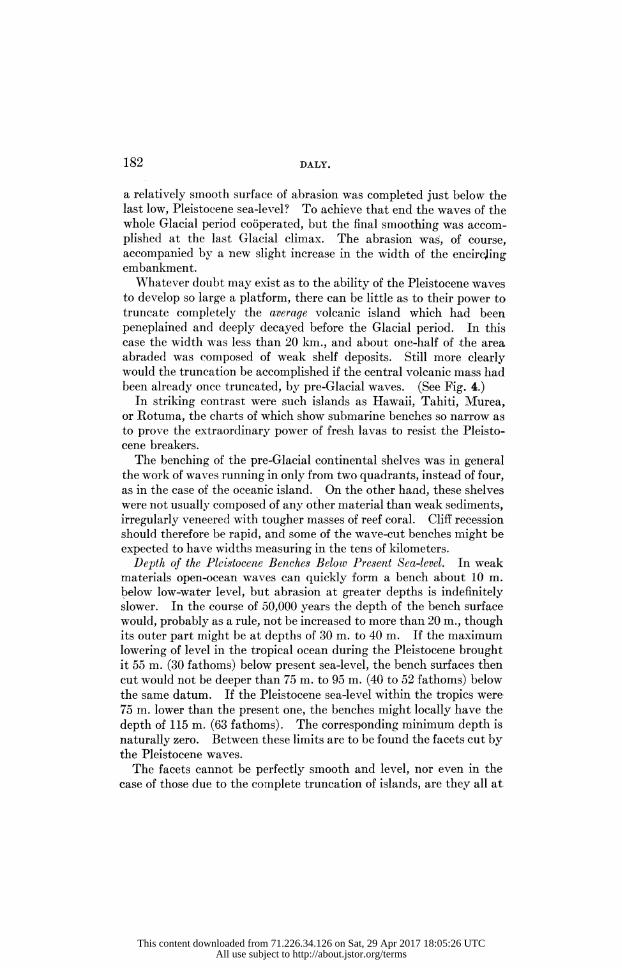
Further, the Glacial-control theory fully recognizes that there has been Recent crustal warping in certain oceanic areas affected by coral reefs.3 Such local subsidence or elevation has influenced the growth
Sections illustrating the development of barrier reefs and atolls. Figure 1. A normal volcanic island. Figure 2. The same island largely peneplained, with the necessary forma
tion of an encircling embankment of detritus (stippled). It is here arbi trarily assumed that there has been no marine abrasion.
Figure 3. The same island, extensively benched by the waves, involving some increase of the embankment. Such benching is expected in very old islands which have been exposed to active abrasion, either because of the Pleistocene chilling of the ocean or because of temporary failure of reef pro tection in pre-Glacial time. Figure 4. Complete truncation of the same island by continued marine
abrasion, with a slight broadening of the embankment. This is a stage that, in many instances, was possibly attained in pre-Glacial periods, as well as during the Pleistocene.
In Figures 2, 3, and 4 the size of the embankment, as drawn, corresponds merely to the bulk of purely inorganic detritus. If intermixed reef and other organic material were allowed for, the embankment must be represented as broader. After the abrasion, fringing, barrier, and atoll reefs would be favor ably located at X, Y, Z, respectively. Shifts of sea-level are not shown.
The sections are drawn to scale and are also intended to show the great areal extent of the weak embankment materials, laid down around old oceanic volcanoes in pre-Glacial time. About one-half of the platform represented in Figure 4 is underlain by these materials, which must have offered little re sistance to the benching surf of the Pleistocene period.
3 In this paper, "Recent" means "post-Glacial" and "recent" means "in late geological time."
This content downloaded from 71.226.34.126 on Sat, 29 Apr 2017 18:05:26 UTCAll use subject to http://about.jstor.org/terms

E
161
This content downloaded from 71.226.34.126 on Sat, 29 Apr 2017 18:05:26 UTCAll use subject to http://about.jstor.org/terms

162 DALY.
of some of the existing reefs. Nevertheless, the bathometric relation of platform to reef is normally so constant in all three oceans that a general explanation of reefs in terms of crustal movements seems im possible. In other words, the coral-reef problem is really the problem of the platform represented in each of the many submarine shelves and lagoon floors of the coral seas. Most of the reef platforms, like many banks situated outside the coral seas, have such forms, dimensions, and relations to the sea-level that they appear to have originated during a long period of nearly perfect stability for the general ocean floor. That is a conclusion forced on the writer by a close study of the marine charts. Its validity is a matter quite independent of the Glacial-control theory. Local uplifts and sinkings of the sea-bottom have certainly taken place, at intervals during past geological time, but submarine topography seems impossible of explanation without assuming crustal quiet beneath most of the deep sea during at least the later-Tertiary and Quaternary periods. The new theory, there fore, is based on the necessity of assuming general crustal stability in the coral-sea areas during the formation of the existing reefs and platform surfaces. Crustal uplift or subsidence must also be assumed as affecting local areas, like the southwest Pacific, within the same time interval, but these phenomena should not be allowed to obscure the main truth which is legible in the bathometry of the tropical seas. Finally, one cannot doubt that general sea-level has been affected
by crustal movements during post-Pliocene time. Recent uplifts have been demonstrated along great stretches of the continental shores. So far as these have not been matched by crustal downwarps beneath the ocean, such uplifts have tended to raise the surface of the ocean everywhere. Hence, post-Glacial time may have witnessed a positive shift of sea-level through a cause that has nothing directly to do with the mere addition of w^ater to the ocean by the melting of ice-caps. A Recent rise of sea-level to the extent of a few meters, owing to post Glacial wTarping of the earth's crust, is quite credible. Some of the submergence so conspicuous in the coral archipelagoes may therefore be due to two distinct causes, both rendering unsafe the drowned valley criterion used by Dana in his advocacy of the subsidence theory.
Earlier Statements of Elements of the Theory.
Many authors, including Adh?mar, Croll, Sir William Thomson (Lord Kelvin), Pratt, Heath, Upham, Penck, Hergesell, and Wood ward, have shown the considerable deformation which must be pro
This content downloaded from 71.226.34.126 on Sat, 29 Apr 2017 18:05:26 UTCAll use subject to http://about.jstor.org/terms

GLACIAL-CONTROL THEORY OF CORAL REEFS. 163
duced in the sea surface by the gravitative attraction of an ice-cap like that covering the northern part of North America in Pleistocene time.4
The lowering of general sea-level by the abstraction of water from the sea, to form one or more ice-caps, and the corresponding rise due to melting of the ice have been discussed by some of the authors men tioned. In 1882, Penck estimated that the Pleistocene glaciation in the northern hemisphere alone sunk the general sea surface 66.5 m. below its present level, assuming that the Antarctic ice-cap was then as large as it is now. If that cap wrere then non-existent, the Pleisto cene sea-level would have been about 50 m. below its present position.5 Von Drygalski calculated that the rise of general sea-level due to melting of the Pleistocene ice-caps has been 150 m., a value later adopted by Penck.6
After the publication of the writer's first paper (1910), Professor D. W. Johnson kindly drew his attention to Belt's statement of the relation between such shifts of sea-level and the origin of coral reefs. As this appears to be the earliest published remark on the subject, it is worthy of quotation: "Another class of phenomena, usually as cribed to a gradual sinking of the earth's crust, but which might also be produced by the return of the sea to the level it stood at before the Glacial period, is that connected with the growth of coral islands. Darwin's celebrated essay on their formation first proved that they were due to the gradual deepening of the water. Dana, closely following Darwin in his theory, estimates that this deepening of the ocean bed from which the coral islands rise has been at least 3,000 feet, and that the subsidence to which he ascribes it extends round one fourth of the earth's circumference in the Pacific, being indicated by atolls in that ocean for 6,000 miles in length and 2,000 in width." 7
Four years later Upham briefly referred to the same theme. After showing that the ocean was diminished as a whole by the growth of
4 J. Adh?mar, R?volutions de la mer, Paris, p. 28 (1840); J. Croll, Climate and Time, London, p. 368 (1875); W. Thomson, Phil. Mag., 31, 305 (1866); J. H. Pratt, ibid., 31,172 (1866) ; D. D. Heath, ibid., 32,34 (1866) ; W. Upham, Geology of New Hampshire, Concord, 3, Part 3, pp. 18 and 329 (1878); A. Penck, Jahresbericht, Geog. Ges. M?nchen, 6, 76 (1881), and Jahrbuch, Geog. Ges. M?nchen, 7 (reprint), p. 31 (1882); H. Hergesell, Gerland's Beitraege zur Geophysik, 1, 59 (1887); E. vor* Drygalski, Zeit. Ges. Erdkunde, Berlin, 22, 274 (1887); R. S. Woodward, Bull. 48, U. S. Geol. Survey (1888).
5 A Penck, Jahrbuch, Geog. Ges. M?nchen, 7 (reprint), p. 29 (1882). 6 E. von Drygalski, Zeit. Ges. Erdkunde, Berlin, 22, 274 (1887); A. Penck,
Morphologie der Erdoberfl?che, Stuttgart, 2, 660 (1894). A. R. Wallace, in Island Life, London, p. 157 (1880), briefly refers to the principle.
7 T. Belt, Quart. Jour. Science, 11, 450 (1874).
This content downloaded from 71.226.34.126 on Sat, 29 Apr 2017 18:05:26 UTCAll use subject to http://about.jstor.org/terms

164 DALY.
the Pleistocene ice-caps, and that the ice attracted the remaining sea water, he wrote : " Such a rise of the sea, increasing in amount at high latitudes, is attested by the modified drift of both America and Europe; and coral islands afford proof of the corresponding depression of the ocean, succeeded by a gradual elevation to its present height, over large areas within the tropics. The coral islands of the tropics are witnesses of a depression of the sea, amounting to 3,000 feet or perhaps much more at the equator, while different proof shows that at the mouths of the Mississippi, Ganges, and Po rivers it was at least 400 feet. If we reflect upon the widespread changes of sea-level that marked the glacial period, occurring only where they would be produced by taking water from the sea to form the ice-sheets, and by gravitation through their influence, and if we compare these recent simultaneous changes with the general stability of the continents, it seems reasonable to attribute them to movements of the sea rather than of the land." 8
Apparently without knowledge of the writings of Belt and Upham, Penck threw out his suggestion in the following form (translated): " The causes of the general rise of sea-level in the latest geological time might perhaps be connected with these climatic changes which the earth underwent in the Glacial period. If, during that time, northern Europe, northern North America, and the Antarctic regions were simultaneously glaciated, a considerable mass of water must have been removed from the ocean, and, if the thickness of the ice be assumed as 1,000 meters, the sea-level must have been 150 meters below its present position. However, it is conceivable that, in conse quence of the considerable cooling, the sea bottom sank during the Glacial period, and since rose again, so that the size of the ocean basins as a whole was not lessened. Whatever explanation is shown in the future to be correct, it cannot be doubted that with a lowering of the sea-level the zone of reef-building must also sink; hence that banks, on which the corals formerly could not live, then became accessible to those animals and could be built up into atolls. Further, with a general lowering of the sea, many banks must become subject to wave abrasion, which truncated them unless they were protected by growing reefs. Thus the lowering of sea-level in the coral-reef region led to the transformation of banks into islands and elsewhere to a further cutting away of the banks. In this way the fact is explained that the great majority of the oceanic islands are found in the coral-reef region, while
8 W. Upham, Geologv of New Hampshire, Concord, 3, Part 3, p. 18 and 329 (1878).
This content downloaded from 71.226.34.126 on Sat, 29 Apr 2017 18:05:26 UTCAll use subject to http://about.jstor.org/terms

GLACIAL-CONTROL THEORY OF CORAL REEFS. 165
outside that zone, submarine platforms (Pfeiler), on which atolls could originate, are rather rare." 9
It was impossible that the ideas of Belt and Upham could be liter ally accepted, because each implied that the late-Glacial swelling of the tropical seas is to be measured in thousands of feet vertically, to match the Darwin-Dana estimates of shifts of level in the coral seas. Geologists might well be sceptical that the formation of the Pleisto cene ice-caps could produce an equatorial drop in sea-level of 3,000 feet, or more. At the present time even the von Drygalski-Penck estimate of 150 meters seems excessive. It will be noted that Penck offered his suggestion with reserve and he apparently rejected it finally himself, as shown by his later, complete acceptance of Darwin's theory, in a Vienna lecture which reviewed the various coral-reef theories but quite failed to mention Glacial controls.10
So far, the writer has found no earlier statement of the second, fundamental control of the Glacial climate, namely, that on the distribution of the corals which throve during the Pleistocene. The killing or great impoverishment of the reef-coral fauna, except in small sea areas protected from the comparatively cold water of the open ocean, is believed to be as essential a feature of the Glacial control theory as the shift of sea-level.
The writer's 1910 paper was a preliminary note; partly on account of its brevity, the first announcement of the theory has been mis understood in some particulars. Additional, prolonged study of ocean charts has led to the appreciation of many facts, especially quantitative data, which were unknown to the writer when the Hawaiian reef problem was undertaken. These facts seem powerfully to support the new theory and, at the same time, to represent strong objections to the subsidence theory of Darwin and Dana. Both theories postulate a recent rise of sea-level within the tropics, but they are utterly contrasted in their meaning for dynamical geology in general. This paper therefore offers a needed fuller statement of the Glacial controls, as well as an analysis of quantitative elements im plied in the older theory of submergence.
9 A. Penck, Morphologie der Erdoberfl?che, Stuttgart, 2, 660 (1894). 10 A. Penck, Vortr?ge d. Verein zur Verbreitung naturwiss. Kenntnisse in
Wien, 36 Jahrgang, Heft 13, (1896).
This content downloaded from 71.226.34.126 on Sat, 29 Apr 2017 18:05:26 UTCAll use subject to http://about.jstor.org/terms

166 DALY.
Pleistocene Temperatures of the Tropical Ocean.
In spite of conflict of views as to the cause of Pleistocene glaciation, it is clear that it was accompanied by some fall of average air tempera ture and of average ocean temperature, in the northern hemisphere at least. In that hemisphere the great ice-caps, then larger than the present ice-caps by nearly 16,000,000 square kilometers in total area, were not merely the result of an atmospheric condition very different from that of the present time. The ice-caps in their turn must have seriously affected the wind system and therefore the system of surface currents in the sea. The annual shifts of the currents and changes in the paths of great storms, characterized by extremes of air temperature, must have often lowered the sea temperature below 20? C, even in parts of the ocean where the mean annual temperature may have been above 20? C. Though occurring but once a year, a few days' exposure to a temperature below that point would seriously endanger the life of the reef-building corals.
The growing belief among glacialists, that the southern hemisphere was locally glaciated at the same time as the northern hemisphere, is a second principal reason for postulating a great restriction of coral reefs in the Pleistocene. The glaciers of the Andes, from the equator to Cape Horn, were much larger than now, at a time which is most probably placed in this geological period. Of similar date are the formerly expanded glaciers of Central Africa and Newr Zealand, and the Antarctic ice-cap seems to have been much thicker and more extensive during the Pleistocene. The notable glaciation of southern regions now bearing no perennial ice, as New South Wales (35? S. Lat.), Western Tasmania (42? S. Lat.), Campbell Island (52.5? S. Lat.), the Auckland islands (51? S. Lat.), Macquarie island (55? S. Lat.), the Falkland islands (51? S. Lat.), and the eastern highlands of South Africa (28? S. Lat.), has been recently referred to the same period.11
For the northern hemisphere special importance must be attached
il C. A. S?ssmilch, An Introduction to the Geology of New South Wales, Sydney, p. 152 (1911); W. H. Twelvetrees, Proc. Roy. Soc. Tasmania, p. 72, (1900); J. W. Gregory, Quart. Jour. Geol. Soc, 60, 37 (1906); E. J. Dunn, Proc. Roy. Soc. Victoria, 6, 133 (1894); P. Marshall, The Subantarctic Islands of New Zealand, Wellington, p. 689 (1909); R. Speight, ibid., p. 705; D. Maw son, The Home of the Blizzard, Philadelphia and London, 2, 292 (1914), and personal communication; A. Supan, Grundz?ge der physischen Erdkunde, 3rd ed., Leipzig, Plate XIII (1903). Compare T. W. E. David, Comptes, rendus, Cong. g?ol. internat., Mexico (reprint, 1907), pp. 31-38 (1906).
This content downloaded from 71.226.34.126 on Sat, 29 Apr 2017 18:05:26 UTCAll use subject to http://about.jstor.org/terms

GLACIAL-CONTROL THEORY OF CORAL REEFS. 167
to the proofs that glaciers, doubtless Pleistocene in date, existed in, or close to, the coral-reef areas of the ocean. Among the more telling instances are those in Hawaii, Japan, Mexico, and East Africa.
Locating all these lands on a world map, the reader will note how inevitable is the conclusion that the tropical seas were considerably cooler during the Pleistocene. Philippi finds further evidence of that fact in the character of the deep-sea ooze collected in the Indian ocean (between 0? and 55? S. Lat.) by the "Gauss" expedition. He shows that the content of calcium carbonate in this deposit decreases with increasing depth and he attributes this decrease to special chemical conditions due to Pleistocene chilling.12 Much more difficult is the question as to the actual amount of
Pleistocene chilling of the tropical seas. The lowering of snow-line at that time was at least 900-1,000 meters in Hawaii and Japan,13 about 1,500 m. in equatorial America, and at least 2,000 m. in equatorial East Africa. With those estimates the Pleistocene lowering of snow line 1,000 to 1,500 m. for Central Europe, about 2,000 m. for southern British Columbia, and nearly 2,000 meters for the northeastern United States, may be compared.
In the lowlands of Java the Selenka expedition found the remains of Pleistocene species of plants which now grow in that island at levels from 600 to 1200 m. higher.14
The average decrease of air temperature with increase of altitude in mountainous districts, for the first 5,000 m. above sea, is about 0.56? C. per 100 m. The average decrease determined only from summit stations is nearly 0.65? per 100 m., which is close to the gradient for free air. These mean values for the decrease practically apply both to the temperate and tropical zones.15
Since the relative precipitation, the relative effect of insolation, and other factors of Pleistocene climates are not determined, the behavior of the Pleistocene snow-line cannot, in general, give a direct value for the average lowering of air temperature within the tropics at that time. The best estimates are doubtless those to be derived from lands
exposed, then as now, to an oceanic climate; for example, Auckland island, New Zealand, Hawaii, Vancouver island, the Coast Range of
12 E. Philippi, Zeit. deut. geol. Ges., 60, 354 (1908). 13 H. Simotomai, Zeit. Ges. Erdkunde, Berlin, No. 1, p. 56 (1914). 14 A. Tornquist, Grundz?ge der Formations- und Gebirgskunde, Berlin, p.
279 (1913). 15 J. Hann, Handbook of Climatology, trans, by R. DeC. Ward, New York,
Parti, p. 244 (1903).
This content downloaded from 71.226.34.126 on Sat, 29 Apr 2017 18:05:26 UTCAll use subject to http://about.jstor.org/terms

168 DALY.
British Columbia, and the Cascade Range of Washington and Oregon. For such regions the free air of Glacial times seems to have been from 6? to 10? C. colder than now. Hann computed the minimum lowering for Spain to be 4.5? C.16 David estimated a similar lowering for New South Wales at not less than 5? C.17
The mean annual temperature, and the mean monthly temperatures of the surface water of the open ocean are almost identical with those respectively belonging to the overlying air. Hence the tropical seas, at the time of maximum Pleistocene glaciation, probably had an aver age temperature of at least 5? C, and possibly as much as 10? C, below their present mean annual temperature.
This result may now be confronted with the data of the following table, compiled from the atlases of the Deutsche Seewarte (Atlantischer Ozean, 1902; Indischer Ozean, 1891; Stiller Ozean, 1893). It gives the present mean monthly temperatures of principal parts of the coral seas.
Temperatures in the Coral Seas, in degrees Centigrade.
Region. February. May. August. November. West Indies 23-26+ 27-28+ 28-29 25-28 Brazilian coast 27-28 27-27+ 25-26 26-27 Gulf of Guinea 27-28 26-28+ 23-25 26-28 Laccadive Islands 27+ 29 26-27 27 Maldive Islands 27-28 28-29 26-27 27-28 Chagos Islands 27-28 27-28 26-27 28 Western part of Indian Ocean 27-28 26-28 24-26 25-27 Andaman-Nicobar Islands 26-27 29 27-28 27 Gulf of Aden 24-26 28-29 26-28 26-27+ China Sea 24-27 28-30 28-29 26-28 SundaSea 27 29 27-28 28 Celebes Sea 27-28 28-29 28+ 27 + ' Bismarck Archipelago 28-29 28-29 28-29 28-29+ Caroline Islands 27-28 28 28-29+ 28 Marshall Islands 26-27 27-28 28-29 27-28 Hawaiian Islands 23-24 24 25 25 Marquesas Island 26 27 28 26 Paumotu (Tuamotu) Islands 25-26+ 24-27 22-26 24-27 Austral Islands 25 24 21 23 Tonga Islands 26 25 23-24 25 New Caledonia 26-27 24-26 22-23 24-25 Great Barrier, Australia 25-28 23-27 20-25 23-27
16 Op. cit., p. 376. 17 Comptes rendus, Cong. g?ol. internat., Mexico (reprint, 1907), p. 34
(1906).
This content downloaded from 71.226.34.126 on Sat, 29 Apr 2017 18:05:26 UTCAll use subject to http://about.jstor.org/terms

GLACIAL-CONTROL THEORY OF CORAL REEFS. 169^
The numbers in bold type show the minimum mean monthly temperatures; slightly lower are, of course, the respective absolute minima.
Remembering the 20? lower limit for reef corals, the reader observes that a mere general fall of only 6? C. in the minima must cause a very extensive destruction of the living animals.18 Further the favorable temperature conditions of the western tropical Pacific and western tropical Atlantic are partly due to the westward driving of abundant warm water by the trade wTinds. In the Glacial period the trade-wind belt must have been much narrower than now, and the effect of these winds correspondingly less. At the same time the general storminess, correlated with rapid shifts of cold currents, was greater than at present. Finally, the Pleistocene extension of the Antarctic ice-cap must have caused some narrowing of the sea south of Cape Horn, with the probable result of increasing the volume of the cold Humboldt current, which now distinctly lowers the temperature of the central Pacific.
For various reasons, therefore, the temperature conditions for lusty coral growth during the Glacial period are not fully suggested even by the statement that the mean annual temperature was then lower than at present by a half-dozen or more degrees. That lowering was but one of several associated causes for the inhibition of coral-reef growth. The writer believes it is not an extreme view to hold that practically the entire area now occupied by the oceanic archipelagoes and by the great barrier reefs of Australia and New Caledonia was, during the maximum Pleistocene glaciation, bereft of reefs growing rapidly enough to resist destruction by the waves. Though meager, slow growth of corals may have been possible in the open ocean, they could only thrive in sheltered bays or seas, especially those along the eastern continental borders within the tropics. In these localities the corals perpetuated their kind, rendering possible a future, more favorable existence in the open ocean. The resulting Pleistocene reefs are, of course, now completely submerged. A likely place for their development was in the southern part of the Red sea, which, in the Glacial period as now, was doubtless particularly warm. The vast, rough plateaus at 60 m. to 120 m. below the surface of that sea, may represent places where reef corals then flourished.
The tropical Atlantic water is to-day cooler than that of the tropical
18 J. D. Dana (Corals and Coral Islands, New York, 3rd ed., p. 108 (1890) states "that the temperature of 68? F. (20?C.) is a temporary extreme ? not that under which the polyps will flourish."
This content downloaded from 71.226.34.126 on Sat, 29 Apr 2017 18:05:26 UTCAll use subject to http://about.jstor.org/terms

170 DALY.
western Pacific or that of the Indian ocean, and, from the proximity of the huge ice-caps of Europe and North America, must have been more chilled during the Glacial period than were the other oceans. This conclusion affords a possible explanation of the thorough con trasts between the reef-coral fauna of the Atlantic and that of the Indo-Pacific province. Hartmeyer says that the species are "niemals identisch/ ' the West Indian species showing a strong excess of Gor gonidae or horn corals.19 The Atlantic and Pacific were connected, across Central America, in the late Tertiary, when, therefore, the reef faunas should have been similar. The closing of this direct passage, during the Miocene or Pliocene, tended to separate the Atlantic reef coral fauna from that of the greater ocean; but even then, because of the failure of a marine-temperature barrier south of Africa, the separa tion may not have been complete. However, since the last Pleisto cene chilling, the low sea temperature has tended to isolate the relict coral fauna of the Atlantic, whereby it remains quite different from the fauna of the Pacific-Indian basin. Reef-coral larvae cannot nowr round Cape Horn. Except for a few weeks in the southern summer, the surface temperatures at the Cape of Good Hope are well below 20?C. Though it is theoretically possible for coral larvae to drift from parent reefs within the Indian ocean into the Atlantic basin, the chance that they could there settle, mature, and propagate is extremely small; for the shortest path of the drifting larvae would be from Madagascar to the Gulf of Guinea, a distance of about 7,000 km. The actual path must necessarily be much longer. One may well doubt that the few larvae which can round the Cape during the southern mid-summer would survive so long a journey. In any case, the thermal barriers between the Atlantic and Indo-Pacific areas of coral reefs have been nearly perfect for much of post-Glacial time. Special destruction of corals in the Atlantic during the Glacial period, together with the influence of thermal barriers, may, then, explain this faunal contrast.
On the other hand, the general absence of identical species in the two oceans might be explained by a rapid evolution of types in this admittedly protean group of animals, since the late-Tertiary closing of the Panaman passage.
The problem of the relation between Pleistocene chilling of the
19 A. Heilprin, The Geographical and Geological Distribution of Animals. New York, p. 248 (1887);?. Hartmeyer, Mitt. Geog. Ges. M?nchen, 3, 129 (1908).
This content downloaded from 71.226.34.126 on Sat, 29 Apr 2017 18:05:26 UTCAll use subject to http://about.jstor.org/terms

GLACIAL-CONTROL THEORY OF CORAL REEFS. 171
Atlantic and the character of the West Indian coral fauna is not solved, but it should be attacked, not only for its zoological significance but also as a future, more complete test of the Glacial-control theory of atolls and barrier reefs in general.
Lowering of Sea-level by Pleistocene Glaciation.
Diminished Volume of Ocean Water. The second main postulate of the Glacial-control theory is likewise difficult to state quantitatively other than in terms of an order of magnitude. The important Pleisto cene ice-caps were five in number. Each of them meant a diminu tion of the volume of the ocean water and also a gravitative lowering of sea-level in the tropical seas. If all the ice-caps reached maximum size simultaneously, and if the area, location, and average thickness of each were known, it would be a rather simple matter to compute the position of Pleistocene sea-level in relation to present sea-level. A similar degree of certainty as to relation of the former level to Plio cene sea-level would still not be attainable, since the question as to the size, and even the existence, of an Antarctic ice-cap during Pliocene time has not yet been answered.
The depth of water off the edge of the Antarctic ice-cap is so great that one cannot assume a Pleistocene area for that sheet much larger than its present area (about 13,000,000 square km. or 5,000,000 square statute miles).20 The probable maximum is about 16,000,000 square km. The present average thickness of the ice is, of course, unknown; the minimum possible estimate is doubtless 300 m. In a personal letter, Professor T. W. E. David states that the Great Ice Barrier has recently decreased much more than 600 feet (183 m.), probably 1,000 feet (305 m.), while the Beardmore glacier, a distributary of the ice cap, has clearly shrunk 2,000 feet (610 m.) vertically. The least assignable average thickness for the whole ice-cap at its greatest strength is probably 600 m., and it may have been three times as great. The present area of the Greenland ice-cap is about 1,900,000 square
km. It may not have been much bigger in the Glacial period; the greatest area of its non-floating portion was probably less than 3,000,000 square km. The present average thickness and the average thickness at maximum strength are alike unknown, but respectively
20 Any submerged portion of the ice-cap is negligible in connection with the main problem.
This content downloaded from 71.226.34.126 on Sat, 29 Apr 2017 18:05:26 UTCAll use subject to http://about.jstor.org/terms

172 DALY.
appear to be of the order of magnitude noted for these averages in the case of the Antarctic ice-cap. The dimensions of the vanished Pleistocene ice-caps are discussed
in the writer's 1910 paper.21 Therein an average thickness of 3,600 feet (1,100 m.) and a total area of 6,000,000 square statute miles (15,500,000 square km.) were assumed, and these values still seem to the writer to be of the right order. The uncertainties as to extension and thicknesses of the great ice
caps, both Pleistocene and modern, make it unnecessary to consider at all the many smaller areas of glaciation, which are thus of no sig nificance in the present problem. Similarly, the displacement of sea-water by those parts of the ice-caps which grew into shallow, epicontinental seas is relatively small and may here be neglected.
For convenience the various rough estimates are indicated in the following table.
Estimated areas, in square kilometers. Estimated average thickness, in meters. Present. Pleistocene. Present. Pleistocene,
Minimum. Maximum. Minimum. Maximum?
Antarctic 13,000,000 16,000,000 300 1,000 (?) 600 1,800 (?) ice-cap
Greenland 1,900,000 2,500,000 (?) 300 1,000 (?) 400 (?) 1,500 (?) ice-cap
Vanished - 15,500,000 - - 1,000 1,500 (?) Pleisto cene ice caps
14,900,000 34,000,000
According to the estimates, the existing ice-caps represent approxi mately 4,500,000 to 15,000,000 cubic km. of ice, corresponding to about 4,000,000 to 13,500,000 cubic km. of water. The area of the whole ocean is nearly 361,000,000 square km. Hence, to form the existing ice-caps, its average level has been lowered below that of an ice-free earth by an amount lying between 11m. and 37 m.
Assuming simultaneous maxima for the major European, Labrador Keewatin, Cordilleran, Greenland, and Antarctic sheets during the Pleistocene, the total ice formed was 26,000,000 to 56,000,000 cubic km., corresponding to about 23,500,000 to 51,000,000 cubic km. of water. The general sea-level would thereby be sunk below that of an
21 Amer. Jour. Science, 30, 300 (1910).
This content downloaded from 71.226.34.126 on Sat, 29 Apr 2017 18:05:26 UTCAll use subject to http://about.jstor.org/terms

GLACIAL-CONTROL THEORY OF CORAL REEFS. 173
ice-free earth by an amount lying between 60 m. and 140 m. The larger limit is close to the estimate of von Drygalski and Penck, above
mentioned. The different estimates of the last two paragraphs imply that the
general sea-level has been raised by an amount ranging between 23 m. and 129 m., since the assumed synchronous, maximum development of the Pleistocene ice-caps. The extreme nature of that assumption makes it improbable that the Recent rise of sea-level has been as much as 129 m. On the other hand, the minimum estimate of the net volume of ice melted since the Glacial climax is likely to be too small. A revision of the evidence has led the writer to favor a rise of sea-level of the order of 50 m. to 60 m. (27 to 33 fathoms). If the climax occurred during the Kansan stage of the Glacial period, secondary maxima in ice-formation and corresponding shifts of level occurred during Wisconsin and other stages. In the 1910 paper an average lowering of 25 fathoms (46 m.) was assumed for all the stages of heavy glaciation.
Gravitative Influence of Ice-caps. Woodward's well known memoir " On the Form and Position of the Sea Level " contains the formulas necessary to compute the deformation of the sea surface due to attrac tion by an ice-sheet. Specially simple and convenient are the equa tions (67) on page 41 of his paper. The table and figure on page 70 are further aids to a quick understanding of the problem and its solution.22 The figure clearly shows the strong uplift of the sea water in the vicinity of the ice-cap and a maximum depression of the water surface at the point antipodal to the center of the mass of ice. The change from positive to negative values, for the case considered, occurs in a zone situated more than 100 degrees of arc from the antipodal point; and, for about 45 degrees from that point, the values for the negative deformation are not far from the maximum.
From Woodward's equation on page 41 it is easy to calculate ap proximately the antipodal sinking of level produced by an ice-cap such as covered northern North America in the Glacial period, pro vided its thickness is known. If the average thickness was 1,000 m., and if the sheet held that thickness nearly to its edge, the antipodal sinking of level caused merely by attraction of the ice would be about 5 m., a value which is directly proportional to the thickness of the ice. The antipodal point for this greatest of the vanished Pleistocene ice caps is in the Indian ocean, southwest of west Australia. That part
22 R. S. Woodward, Bull. 48, U. S. Geol. Survey (1888).
This content downloaded from 71.226.34.126 on Sat, 29 Apr 2017 18:05:26 UTCAll use subject to http://about.jstor.org/terms

174 DALY.
of the ocean would be specially affected by the gravitative depression of water level. Elsewhere the tropical seas would in less degree feel the same effect, to which must be added the lowering effect of contem poraneous glaciers in Europe and other regions of the globe. The total gravitative effect of all excess Pleistocene ice was probably nowhere within the tropics sufficient of itself to lower sea-level as much as 15 m.; an average for the coral-sea zone of 10 m., or about 5 fathoms, may be assumed without involving serious error in the following discussion.
Conclusion. Combining results, it is seen that, at the time of maxi mum glaciation, the tropical seas probably had an average level which was 60 m. to 70 m. (33 to 38 fathoms) lower than at the present time.
Islands and Continental Shores During the Glacial Period.
The full consequences of Pleistocene chilling and lowering of the tropical-sea level represent a problem having to do with the nature of the Pleistocene land masses and shoals, and with the amount of abrasion by Pleistocene waves.
Character of the Shore Rocks. The extent of wave-benching at the low sea-levels of Pleistocene time must have been highly variable, owing to the enormous differences in the resistance of the materials composing the shore belts of islands and continents alike. At the first low-water stage those materials would include the following:
1. Massive, strong lavas, among which were the flows erupted during the shift of level;
2. Weak pyroclastic deposits associated with those lavas; 3. Strong volcanic or other formations exposed to wave action
through faulting or other types of crustal movement; 4. Very weak mud and sand deposits which had been formed
under the'sea by destruction of pre-Glacial lands and coral reefs; 5. Similar deposits locally somewhat strengthened by interbedded
coral reefs or by calcareous cementation; 6. Mixtures of weak sediments or pyroclastic deposits with occa
sional stronger lava flows; 7. Coral reefs of pre-Glacial age; 8. Weak deposits of shells etc., formed in offshore banks before the
shift of level; 9. Comparatively weak material residual after the secular weather
ing of the pre-Glacial lands.
This content downloaded from 71.226.34.126 on Sat, 29 Apr 2017 18:05:26 UTCAll use subject to http://about.jstor.org/terms

GLACIAL-CONTROL THEORY OF CORAL REEFS. 175
Regarding some of these shore-line materials special consideration is necessary. Numbers 4, 5, and 6 refer to continental shelves and to submarine embankments encircling islands, and were of breadth depending on the antiquity of the land masses concerned. The breadth of the continental shelf, such as that off eastern Australia, measured scores of kilometers; the embankments surrounding large, very old islands w^ere generally narrower but doubtless often measured many kilometers in width. Initially, the plains underlain by the marine sediments, laid bare during the first Glacial maximum, would vary in elevation, the highest parts being above the new sea-level by just the amount of the negative shift from the pre-Glacial sea-level. The coral reefs of pre-Glacial age formed steep initial bluffs over
looking the new sea-level. The average massive coral is more re sistant to wave abrasion than the loose deposits just mentioned but is much less resistant than an un weathered lava flow. Observation shows an ordinary reef to be greatly weakened by lenses of sand and poorly cemented coral breccia. If the sea-level fell as much as 60 m., the massive coral, only 35 to 50 m. thick and resting on talus sand and blocks, would be liable to undermining, and therefore quick destruc tion, by the waves. The friable nature of the talus and other material underlying the existing reefs is suggested by the logs of borings in Florida, Funafuti, Bermuda, Sumatra, and the Hawaiian islands.23
How wide the pre-Glacial reefs were, it is impossible to say. Among other things, their width depended on the antiquity of the present coral-reef fauna as a whole. There is no evidence that it dates back of the Jurassic period, nor, indeed, is it proved that the present coopera tive habit of these species was well established before the Miocene.
Hence one cannot assume the pre-Glacial islands or continents to have been fringed with indefinitely wide reefs.
Paleozoic and younger organic growths of all kinds were liable to wave-benching until protected, apparently in late geological time, by the "invention" of strong coral reefs. Even now, many reefs are just able to hold their own against the breakers; others have been completely truncated during recent years; and still others, the so called "drowned atolls," have long failed to reach the surface at all.
23 E. O. Hovey, Bull. Mus. Comp. Zool., 28, No. 3 (1896); The Atoll of Funafuti, published by the Royal Society of London, 1904; L. V. Pirsson, Amer. Jour. Science, 38, 191 (1914); C. P. Sluiter, Petermann's Geog. Mitt., 1891, Lit. Ber., p. 46; A. Agassiz, Bull. Mus. Comp. Zool., 17,121 (1889).
The figures stating the range of thickness for the exposed reefs are deduced from the well-known depth limits of vigorous growth of reef corals.
This content downloaded from 71.226.34.126 on Sat, 29 Apr 2017 18:05:26 UTCAll use subject to http://about.jstor.org/terms

176 DALY.
Moreover, it is not certain that, after the cooperative reef-building habit was well established, the tropical-sea temperature was not for a time too high for vigorous growth of reef corals. Mayer's experiments have led him to conclude that these would be killed if the ocean tem perature were as high as 98? F. (36.7? C). According to some of the experiments certain species ceased to take food at temperatures below 98? F.24 This temperature is only 12? F. (6.7? C.) higher than that of the warmest surface water of the present ocean. The question arises as to the tropical-sea temperatures during that part of Tertiary time when Grinnell Land, at 81? 44' N. Lat., had a mean July tempera ture about 27? F. higher than it enjoys now, while the mean January temperature was then at least 50? F. higher than now.25 Of course one cannot assume that the tropical sea was then correspondingly warmer than at present, but the possibility of a temporary lowering of vitality in the reef corals through excessive heat cannot be easily dismissed. More certain is the fact that, though Tertiary coralliferous lime
stones of great extent and thickness appear in Fijian and other up lifted islands, no very wide, typical coral reefs appear yet to have been found among them.26 Thus, the idea is to be entertained that massive coral structures of
Tertiary or earlier age did not greatly retard wave abrasion during the Glacial period.
The degree to which the rocks of the oceanic islands were weakened by deep weathering during pre-Glacial time varied with the antiquity of those islands. They certainly had very different dates of origin. Like all the continents, the area of the tropical seas was probably affected by strong volcanic action in the early pre-Cambrian, as well as occasionally through all subsequent time. Presumably the major ity of the Pacific-floor volcanoes are pre-Pliocene, if not pre-Tertiary in age. If this be true, the oldest volcanic islands, long before the
24 A. G. Mayer, Pop. Sei. Monthly, Sept., p. 219 (1914). 25 According to J. Hann, Handbook of Climatology, trans, by R. DeC. Ward,
New York, 1,375(1903). 26 H. B. Guppy (Observations of a Naturalist in the Pacific between the
years 1896 and 1899, London, 1, 7 (1903)) concluded that coral reefs do not appear to have existed in Vanua Levu (Fiji) when that island began its.2,000 foot uplift. He also notes that " coral reefs never have been very extensive at the sea-border during the last stages of emergence" of that island. The dating of the Vanua Levu uplift is evidently a matter of great importance, on which, however, information is scant. It doubtless began long before the Glacial period.
This content downloaded from 71.226.34.126 on Sat, 29 Apr 2017 18:05:26 UTCAll use subject to http://about.jstor.org/terms

GLACIAL-CONTROL THEORY OF CORAL REEFS. 177
Glacial period, must have suffered peneplanation or great reduction and then decomposition by down-seeping soil waters. The great depth ? 100 m. or more ? for the shell of decayed rock is well illus trated in the southern Atlantic states of the North American Union, in Brazil, and in many other tropical lands of the present day. Heights of the Pleistocene Islands. The rate of wave-benching was
necessarily controlled in part by the volume of rock to be removed by the waves; hence the range of heights for the different kinds of islands and coastal plains is an important element in the problem. For convenience, the symbol d may be used to represent the vertical (downward) shift of sea-level at a time of maximum glaciation. Simi larly, h may represent the height of the land before glaciation set in; and II, the height of the land above sea after the shift of sea-level.
In the case of the young volcanic islands, h had values up to a limit of about 4,000 m. At the other extreme were the very old, stable islands, for which h approached zero in value; for them H and d were nearly equal. Other ancient islands, which had been affected by crustal uplift, may have passed through more than one erosion cycle, with final peneplanation. Still others, once peneplained or greatly reduced in volume, may have sunk well below sea, and then, in pre Glacial time, received a veneer of organic d?bris, whereby the surface of each of these "banks" was brought close to the Pleistocene ocean level. For such islands also, H and d were of the same order of
magnitude. The parts of the benches cut by pre-Glacial waves and not veneered with coral or other growths, would furnish islands with H less than d. For the continental shelves and purely fragmental embankments about islands, H varied in value from zero to that of d. For coasts surrounded by pre-Glacial fringing reefs, the average value of H was nearly equal to d. For offshore banks of mud, shells, or ooze within the tropics, H was generally less than d, by at least 35 to 45 m., since, by hypothesis, they were covered in pre-Glacial time by water too deep for vigorous coral growth.
Conclusions. Reviewing the facts and reasonable inferences, it therefore appears that most oceanic islands, at the time of maximum glaciation, were (a) low, with II ranging between zero and a value little greater than d; and (b) composed of generally weak material ? detrital embankments surrounding or covering an eroded central mass of decayed volcanic rock, which itself was likely to be weak also because of the presence of ash-beds. The encircling talus embank ment carried veneers of coral-reef material of varying strength.
The new coastal plains along the edges of continents and greater
This content downloaded from 71.226.34.126 on Sat, 29 Apr 2017 18:05:26 UTCAll use subject to http://about.jstor.org/terms

178 DALY.
islands were all low and mostly composed of very weak materials. It is probable that these gigantic embankments were only partly veneered with massive reef material; such comparatively strong rock was in danger of undermining and rapid destruction as soon as the sea-level fell 45 m. or more, because of glaciation in higher latitudes. On the other hand, the high volcanic islands were young. Their
rocks were still not essentially weakened by decay, and, as to-day, largely consisted of strong, massive lava flows. Wave-benching in such material would be incomparably slower than in that of the older islands or of the continental shelves.
Origin of the Coral-Reef Platforms.
Size of the Actual Platforms. The lengths and breadths of the larger reef platforms are typified in the following list:
Ontong Java atoll (Solomon islands) Macclesfield bank (China Sea) Australian Great Barrier Chagos Bank (Indian ocean) Suvadiva atoll (Maldives) Miladummadulu-Tiladummati atoll
(Maldives)
Length Km. 80 150
2,000+ 150 80
145
Extreme breadth Km. 30 55
50-185 110 65
3.0
The large majority of the platforms have lengths less than 30 km. and widths less than 20 km. In a consideration of their possible smoothing by surf action, width is much more important than length. (See also Table I at page 187.) Pre-Glacial History of Volcanic Islands. Both a priori reasoning
and direct deduction from the known submarine contours about islands like Hawaii and Tahiti, warrant the conclusion that the largest and middle-sized platforms could not be caused by the abrasion of young volcanic masses during the Pleistocene. To review the situa tion for the volcanic islands of great age, an ideal case may be considered. Assume that a conical island of normal volcanic com position (mixed lava flows and ash beds) was formed so long ago as to have been thoroughly planed down by erosion. The encircling embankment of d?bris would contain the insoluble material washed out of the island, and in this would be incorporated shells and skele
This content downloaded from 71.226.34.126 on Sat, 29 Apr 2017 18:05:26 UTCAll use subject to http://about.jstor.org/terms

GLACIAL-CONTROL THEORY OF CORAL REEFS. 179
tons of pelagic and shallow-water organisms. On account of the length of time involved in the erosion (peneplanation aided by wave scour), the organic increment to the terrace would be very great, perhaps rivalling the inorganic material in bulk. If the island were circular, with an original slope of 1: 6 (nearly the average slope of young vol canic islands) above and below sea-level, the embankment would probably have an average width at least one-third as great as the initial radius of the island. The total area within the 50-meter isobath, including the central outcrop of undisturbed rock, would be nearly double the original area of the island.
The result of the calculation suggests that a large percentage of the area occupied by each of many Pleistocene islands would offer rela tively small resistance to the waves of that period.
For the area of the initial island more than one possibility must be weighed. If sea-level had remained constant throughout the preced ing erosion cycle, and if the island had escaped marine planation, the volcanic rocks must have been more or less deeply weathered and weakened. After the Pleistocene shift of sea-level, their surface would be nearly at the height d above the new level. On the other hand, if the island had been truncated by waves, because of a temporary failure of reef protection during pre-Glacial times, the height of its central lavas above the new Pleistocene sea-level would be less than d by some tens of meters.
Duration of Pleistocene Abrasion. As the facts concerning Pleisto cene glaciation become better known, geologists are becoming steadily more convinced of the notable length of the Glacial period as a whole. Because of their wide experience and deep study, the estimate of Chamber lin and Salisbury is worthy of special emphasis. They regard the time elapsing between the climax of the Kansan stage and the climax of the Wisconsin stage as probably between 280,000 and 960,000 years. For the entire period other milleniums must be added, to represent the time during which the Kansan ice grew to its full thick ness, and for the Sub-Aftonian stage, if the latter really was a time of widespread glaciation.27 When Bain showed how thoroughly the Kansan drift has been dissected by post-Kansan streams, he laid the foundation for general belief that intense Pleistocene glaciation began at least 300,000 years, if not at least 500,000 years, before the ice-caps of the Wisconsin stage began to wane.
Reliable estimates of the total duration of a greatly lowered sea
27 T. C. Chamberlin and R. D. Salisbury, Geology, New York, 3, 420 (1906).
This content downloaded from 71.226.34.126 on Sat, 29 Apr 2017 18:05:26 UTCAll use subject to http://about.jstor.org/terms

180 DALY.
level within the tropics are harder to make. They must depend on an assumption as to the life of each full-bodied mass of ice after it has been once formed. That the later ice-sheets long persisted with considerable thickness is shown by the depths of fiord and other basins which have been glacially excavated. The imposing depth and breadth of the Grand Coulee in Washington State, cut by the Columbia river during merely a sub-stage in the last Glacial maximum of the Cordillera, is another qualitative proof. If the rate of ice movement at the climax of the Wisconsin stage were known, it might be possible to give a minimum estimate for the duration of that climax; the data would be found in the distribution of special types of erratics, especially either those derived from high nunataks, or those carried over high masses like the Adirondacks or White Mountains.
Though the whole subject is very obscure, the general probabilities, viewed in relation to the estimates by Chamberlin and Salisbury, suggest a period of from 50,000 to 200,000 years for the time during which the Pleistocene ice-caps were nearly or quite at their greatest volume. During that total period the tropical ocean had a level lower than now by an amount ranging from 30 m. to 75 m. Then occurred the deeper benching and smoothing of platforms by waves and cur rents.
Nevertheless, the sea was actively attacking the islands and conti nental coasts throughout nearly the whole Glacial period. The reef building corals were largely killed off long before the ice-caps of the first Glacial stage reached their full size. The succeeding Inter glacial stage may have witnessed a partial re-establishment of reefs in the open ocean, but, if so, such reefs must have been relatively feeble and short-lived defenders of the islands. Similar reasoning applies to the other recognized stages of the Glacial period. Hence, though sea-level swung down and up several times, lively wave abra sion must have been almost continuous.
Rate of Pleistocene Wave-benching. Unfortunately little is accurately known concerning the speed with which ocean waves can drive in shore cliffs on the deep-sea islands. Most of the measurements so far
made refer to coastal points affected only by the less powerful waves of the North Sea, the Mediterranean, or the inner edge of the conti nental shelf of Europe. The clayey cliffs of Yorkshire, England, retreat at the rate of 2 m. to 4.5 m. per annum. Matthews states that the shore-lines of Suffolk and Norfolk (also on the east coast) are being driven in at rates of from 3.5 m. to 14 m. per annum, while the rate for the Welsh coast, between Llanelly and Kidwelly (Bristol Channel)
This content downloaded from 71.226.34.126 on Sat, 29 Apr 2017 18:05:26 UTCAll use subject to http://about.jstor.org/terms

GLACIAL-CONTROL THEORY OF CORAL REEFS. 181
is nearly 2 m. per annum.28 The average rates of annual recession for the chalk cliffs of Normandy and for those of Dover are said to be, respectively, 0.3 m. and 1 m. Fischer found the rate for the hard rocks of Algiers to be 10 m. in 1,200 years.29
The average rock-strength of most of the Pleistocene islands and coastal plains was doubtless no greater, and probably less, than that of the Dover cliffs, which also have height of the same order as the quantity d. On the other hand, the energy of the waves annually breaking on the English cliffs is less than that of the waves annually breaking on an equal length of coast-line in the oceanic islands.30
If, as is probable, the tropical ocean was more stormy in the Glacial period than it is now, the rate of cliff recession was correspondingly higher.
The peneplanation of an oceanic island, initially as large and lofty as Hawaii, would produce a composite of volcanic and shelf material about as extensive as the Macclesfield bank, one of the very larg est coral platforms known (a "submerged atoll"). Such a mass would be attacked on all sides by the strong Pleistocene waves. The pre-Glacial embankment of sand, mud, and organic d?bris would yield at least as fast as the clayey cliffs of Yorkshire are receding before the relatively small waves of the North Sea. Probably 2 m. per annum would be the minimum rate of recession for cliffs developed in these shelf deposits. If the lava flows of the central mass were deeply weathered, the rate of cliff recession there might average 0.5 m. or more per annum.
As already observed, the wave abrasion began before the climax of the Kansan stage and continued without serious interruption until the Wisconsin climax ? a period estimated as 280,000 to 900,000 years. Is it too extreme to hold that, during such a long period, the surf of the open ocean, sweeping in on all sides, would abrade every part of an island even so extensive? Is it too extreme to believe that
28 E. R. Matthews, Coast Erosion and Protection, London, pp. 11, 21, 22 (1913).
29 See E. Br?ckner, in Allgemeine Erdkunde (Hann, Hochstetter, and Pok orny), Prag and Wien, Abt. 2, p. 260 (1897).
30 This statement holds true in spite of the fact that wind waves are specially aided by the tides in their attack on the cliffs of England. C. Darwin (The Structure and Distribution of Coral Islands, London, 3rd ed., p. 86 (1889)) remarked that, if the corals of any one of the many low coral islands were killed, the whole island " would be washed away and destroyed in less than half a century." On page 129 of his book he notes that a single storm entirely truncated two of the Caroline islands and partly destroyed two others. Many similar cases are on record.
This content downloaded from 71.226.34.126 on Sat, 29 Apr 2017 18:05:26 UTCAll use subject to http://about.jstor.org/terms
182 DALY.
a relatively smooth surface of abrasion was completed just below the last low, Pleistocene sea-level? To achieve that end the waves of the whole Glacial period cooperated, but the final smoothing was accom plished at the last Glacial climax. The abrasion was, of course, accompanied by a new slight increase in the width of the encircling embankment. Whatever doubt may exist as to the ability of the Pleistocene waves
to develop so large a platform, there can be little as to their power to truncate completely the average volcanic island which had been peneplained and deeply decayed before the Glacial period. In this case the width was less than 20 km., and about one-half of the area abraded was composed of weak shelf deposits. Still more clearly would the truncation be accomplished if the central volcanic mass had been already once truncated, by pre-Glacial waves. (See Fig. 4.)
In striking contrast were such islands as Hawaii, Tahiti, Murea, or Rotuma, the charts of which show submarine benches so narrow as to prove the extraordinary power of fresh lavas to resist the Pleisto cene breakers.
The benching of the pre-Glacial continental shelves was in general the work of waves running in only from two quadrants, instead of four, as in the case of the oceanic island. On the other hand, these shelves were not usually composed of any other material than weak sediments, irregularly veneered with tougher masses of reef coral. Cliff recession should therefore be rapid, and some of the wave-cut benches might be expected to have widths measuring in the tens of kilometers. Depth of the Pleistocene Renches Reloiv Present Sea-level. In weak
materials open-ocean waves can quickly form a bench about 10 m. below low-water level, but abrasion at greater depths is indefinitely slower. In the course of 50,000 years the depth of the bench surface would, probably as a rule, not be increased to more than 20 m., though its outer part might be at depths of 30 m. to 40 m. If the maximum lowering of level in the tropical ocean during the Pleistocene brought it 55 m. (30 fathoms) below present sea-level, the bench surfaces then cut would not be deeper than 75 m. to 95 m. (40 to 52 fathoms) below the same datum. If the Pleistocene sea-level within the tropics were 75 m. lower than the present one, the benches might locally have the depth of 115 m. (63 fathoms). The corresponding minimum depth is naturally zero. Between these limits are to be found the facets cut by the Pleistocene waves. The facets cannot be perfectly smooth and level, nor even in the
case of those due to the complete truncation of islands, are they all at
This content downloaded from 71.226.34.126 on Sat, 29 Apr 2017 18:05:26 UTCAll use subject to http://about.jstor.org/terms

GLACIAL-CONTROL THEORY OF CORAL REEFS. 183
the same depth below present sea-level. That depth depends: (a) on the power of the waves, varying with storminess, length of fetch, etc.; (b) on the highly variable strength of the island formations; (c) on the original areas and heights of the islands; and (d) on the differ ent values for the lowering of tropical-sea level because of gravitative attraction by the ice. The control last mentioned is slight and for general purposes may be neglected, though it may partly explain the unusual depth of water now in the main Chagos lagoon of the Indian ocean. Each of the other controls was doubtless of nearly equal efficiency in the three oceans, so that in general the platforms should be at depths ranging between 60 m. and 100 m.
The zero depth for the facets is nearly illustrated in such a case as Manga Reva (Gambier Islands), where small masses of hard volcanic rock rise as islands in the midst of a barrier-reef platform, on which are all depths down to 73 m. (40 fathoms). These islands are clearly residuals of one or more larger volcanic masses. According to the Glacial-control theory they have been separated by long subaerial and marine erosion and not by crustal subsidence, as stated by Darwin. Yet the wave-cut, Pleistocene facet does not appear at the present shores of these and similar islands, partly because the latter were suba?rially eroded during the lower stand of sea-level in the Glacial period; some of the existing bays are drowned stream valleys.
Depths of Lagoons and of Coastal Shelves in Stable Areas. The attempt to state quantitatively the effect of Pleistocene wave abrasion is seen to be laden with difficulties. However, a fair judgment seems to indicate that composite benches, of area and depth corresponding to the platforms from which the present coral reefs rise, were then actually cut in islands and coastal plains. This conclusion is subject to two different tests.
Since their completion, the Pleistocene benches have been veneered with shells and skeletons of pelagic organisms, with d?bris of coral reefs, and with knolls and linear reefs of growing corals. Besides sporadic, steep-sided knolls of coral, the lagoons, covering 95 to 99 per cent of the larger atoll platforms, have a nearly continuous bottom layer of calcareous mud, sand, and organic remains. The smaller the platform, the higher was the proportion of reef d?bris in the veneer, and the more rapidly has the lagoon area been shallowed. (Figs. 5-11.) On the other hand, each large lagoon should be of nearly uni form depth over its central part. Wherever two or more large atolls were subject to similar conditions for reef growth and for pelagic life, the average depths of their lagoons should vary only within small limits.
This content downloaded from 71.226.34.126 on Sat, 29 Apr 2017 18:05:26 UTCAll use subject to http://about.jstor.org/terms

184 DALY.
The following table (I) shows the depths in representative lagoons and on large banks which lack rimming reefs. The mean width of the broader part (not the maximum width) is given in Col. 1. Column 2 gives the maximum depth of lagoon or bank. For lagoons, Col. 3 gives the mean depth for a considerable area where the water is deepest; for banks, it gives the mean depth on the larger part of the flat top of each bank. In this column the values given are merely estimates, but they assist in giving a mental picture of the submarine relief. Between the ordinary atoll and the reefless bank is a type sometimes called a "drowned atoll," whose rimming reef is submerged because of the periodic killing of its corals. (See page 214.) The depth data for " drowned atolls " are likewise entered in the table.
Sections of small and middle-sized atolls. Figure 5. Peros Banhos, Chagos group. Figure 6. Salomon Islands cluster, Chagos group. Figure 7. Six Islands cluster, Chagos group. Figure 8. North Minerva, 23? 37' S. Lat. and 178? 56' W. Long. Compare
Figure 11. Figure 9. Wataru, Maldives. Figure 10. Section through one of the rare cays of Loai ta " drowned
atoll, " China Sea. Figures 5 to 9 illustrate the rule that the lagoons of small atolls are more
filled with detritus than those of larger atolls. Comparison of them with Figures 10, 15, 19, 20, 33, and 34 shows lagoons of "drowned atolls" to be deeper than the lagoons of atolls with reefs awash or reaching the sea surface, lagoons of nearly equal diameters being compared in each case. Uniform scales; vertical scale is 5 times the horizontal scale. Depths in,
fathoms. Water is shown in black; rocks, including the reefs, are lined.
This content downloaded from 71.226.34.126 on Sat, 29 Apr 2017 18:05:26 UTCAll use subject to http://about.jstor.org/terms

<n
m
m in
m
m
m
<n
co?
185
This content downloaded from 71.226.34.126 on Sat, 29 Apr 2017 18:05:26 UTCAll use subject to http://about.jstor.org/terms

186 DALY.
201
131
/SO es
55
200 es
Figure 11. Chart of North Minerva atoll, 23? 37' S. Lat. and 178? 56' W. Long. Compare Fig. 8. Scale, 1: 74,000. Depths in fathoms.
This content downloaded from 71.226.34.126 on Sat, 29 Apr 2017 18:05:26 UTCAll use subject to http://about.jstor.org/terms

GLACIAL-CONTROL THEORY OF CORAL REEFS. 187
TABLE I.
Depths in Lagoons and on Banks.
Width of Maximum Mean depth in platform depth deeper part
(Km.). (M.). (M.).
Barrier Lagoons. Pacific Ocean.
Great Barrier, Australia 10-12? S. Latitude 130 59 30 12-14 " 65 49 30 14-16 " 61 62 45 16-18 " 65 68 55 18-20 " 120 77 50 20-22 " 185 83 55
New Caledonia (north end) 46 40 33 Fiji Group Viti Levu (northwest side) 37 75 64 Viti Levu (northeast side) 17 64 37 Viti Levu (south side) 4 40 27 Vanua Levu (west side) 56 84 57 Vanua Levu (southeast side) 13 62 59 Wakaya (nearly an atoll) 7 64 49 Mbengha 13 59 29 Kandavu 4 38 22 North Astrolabe (nearly an atoll) 4 27 18 Great Astrolabe 6 41 30 Ngau 6 53 38 Nairai 4 38 26 Makongai 4 39 29 Moala 4 44 18 Budd-Iambu (nearly an atoll) 8 91 73 Oneata 6 37 31
Society Group Tahiti (northwest side) 4 49 20 Borabora 2 49 20 Raiatea 2 70 33
Caroline Group ? Truk (Ruk) 28 66 46 Manga Reva (Gambier Islands) 7 69 27
Indian Ocean.
Mayotta, Comoro Group 14 71 37
This content downloaded from 71.226.34.126 on Sat, 29 Apr 2017 18:05:26 UTCAll use subject to http://about.jstor.org/terms

188 DALY.
Width of platform (Km.).
Atolls.
Pacific Ocean. Off Great Australian Barrier
" Great Detached Reef " 7 Flinders 24 Saumarez 22 Bampton 24
Solomon Group Tasman or Niumano 14
North Minerva, 23? 37' S. Lat., 179? W. 5 Long.
South Minerva 3 Fiji Group
Thakau Matathuthu 4 Thakau Vuthovutho 6 Ngele Levu 9 Ringgold 7 Wailangilala 4 Duff 4 Reid 9 North Argo 7 South Argo 15 Thakau Tambu 4 Aiwa 4
Ellice Group Funafuti 13
Caroline Group Namonuito 30 Ulie 4 Lukunor 7
Marshall Group Arno 11 Wotje (Romanzoff) 17
Phoenix Group Canton 4 McKean (dry atoll) 1 Birnie (reef awash) 1
Paumotu (Tuamotu) Group Hao 15 Mururoa 9 China Sea.
Thi tu (west atoll) 4 Thi tu (east atoll) 3
Maximum depth (AT.).
60 60 69 65
37 31
29
35 29 29 94 42 42 37 38 66 20 42
55
48 46 53
60 51
20 0 0
59 28
35 27
Mean depth in deeper part
(M.).
36 53 46 55
31 22
18
27 27 22 60 33 18 33 27 53 15 33
46
40 33 38
38 45
15 0 0
45 22
27 11
This content downloaded from 71.226.34.126 on Sat, 29 Apr 2017 18:05:26 UTCAll use subject to http://about.jstor.org/terms

GLACIAL-CONTROL THEORY OF CORAL REEFS. 189
Width of Maximum Mean depth in platform depth deeper part (Km.). (M.). (M.).
Atolls. China Sea.
Crescent (Paracel Islands) 13 75 46 Vuladdore (awash or dry reef patch) 4 0 0 North Reef, near last, reef patch 4 0 0
Indian Ocean.
Keeling (Cocos) 11 24 9 Ile Desroches, 5? 40' S. Lat., 53? 40' E. 16 31 26
Long. Chagos Group
Diego Garcia 9 33 26 Peros Banhos 20 69 45 Salomon Islands 5 31 20 Egmont (Six Islands) 3 24 15 Blenheim 4 18 11
Maldive Group Fu? Mulaku 10 0 Addu 9 71 55 Suvadiva 56 88 69 Hadummati 31 77 64 Kolumadulu 37 87 70 Mulaku 23 73 60 South Nilandu 22 71 59 North Nilandu 22 69 57 Wataru 6 38 31 Felidu 18 75 55
Ari 28 79 55 South Male 15 68 49 Rasdu 7 42 27 North Male 28 71 55
Gaha 7 40 33 Horsburgh 7 42 37 Fadiffolu 18 59 46 South Malosmadulu 26 69 46 Middle Malosmadulu 9 49 37 North Malosmadulu 22 57 42 Miladummadulu 28 60 42 Makunudu (Malcolm) 4 31 18 Tiladummati 20 57 38 Ihavandiffulu 11 62 46 Minikoi 5 15 9
This content downloaded from 71.226.34.126 on Sat, 29 Apr 2017 18:05:26 UTCAll use subject to http://about.jstor.org/terms

190 DALY.
Indian Ocean.
Laccadive Group Suheli Par Agatti Peremul Par Bitra Byramgore Cherbaniani
Width of platform (Km.).
Atolls.
Maximum depth (M.).
11 4 13
11 6
Mean depth in deeper part
(M.).
7 2 5 4 4 4
Pacific Ocean. North of Fiji Group
Alexa Penguin Turpie Waterwitch
China Sea. Macclesfield Tizard Rifleman Loai ta North Danger Seahorse (Routh)
Indian Ocean. Chagos Group
Great Chagos Pitt Speakers Victory
" Drowned Atolls."
15 12 18 7
55 15 20 13 7 7
100 25 22 4
46 48 55 53
110 87 82 62 49 57
90 55 45 6
42 44 46 48
77 73 60 55 38 40
75 35 38 2
Rimless Banks.
Pacific Ocean. Thikombia (Fiji Group) 7 Cortez (off California) 15 Tanner " " 7
China Sea. Prince Consort 13
Indian Ocean. Saya de Malha, south bank (rimmed on 110
north; greatest depth on south) Saya de Malha, north bank 46
91 95 97
81
128
73
60 75 80
73
55
This content downloaded from 71.226.34.126 on Sat, 29 Apr 2017 18:05:26 UTCAll use subject to http://about.jstor.org/terms

GLACIAL-CONTROL THEORY OF CORAL REEFS. 191
Width of platform (Km.).
Rimless Banks. Indian Ocean.
Nazareth Seychelles Amirante (partly rimmed) Bassas de Pedro (Padua) Cora Divh Sesostris Rodriguez island (shelf on west side) Wadge, (off west coast of India) Ceylon, shelf of east coast Ceylon, shelf of west coast (rim at 46
55 m.) Atlantic Ocean.
Hotspur, 18? S. Lat., 36? W. Long. Rodgers, 17? S. Lat., 37? W. Long. Victoria, 20? 30' S. Lat., 38? W. Long. Dacia, 31? N. Lat., 14? W. Long. Challenger, southwest of Bermuda Argus, near last
130 150 35 22 11 13 20 7
22 24
22 13 22 7 7' 10
Maximum depth (M.).
82 73 64 69 70 77 75 63 91 77
82 91 73 107 73 73
Mean depth in deeper part
(M.).
46 58 55 51 53 45 60 55 55 60
64 62 60 100 60 59
Though the conditions affecting these oceanic areas are, and long have been, highly variable, it is instructive to note the relation of the maximum depth to width of the platform. Average values for the two elements have been computed and the results given in Table II. Similar averages for general depths on banks and in the deeper parts of lagoons are also there entered.
TABLE II.
Depths of Lagoons and Banks in Relation to Widths of Platforms.
Atoll Lagoons Width of platform.
1-5 km. inclusive 6-10 " 11-20 " 21-30 " 31-60 "
Number averaged.
23 19 15 12 3
Average of maxi mum depths
(meters).
21 38 57 66 84
Average of mean depths in
deeper parts (meters).
16 28 41 51 68
Barrier Lagoons 2-10 (excluding Great 11-20 Australian Bar- 21-60 rier)
15 4 4
50 64 66
27 41 50
This content downloaded from 71.226.34.126 on Sat, 29 Apr 2017 18:05:26 UTCAll use subject to http://about.jstor.org/terms

192 DALY.
Number Width of platform. averaged
"Drowned" Atolls 1- 10km. inclusive 4 11- 30 " " 8 31-100 " " 2
Average of maxi mum depths
(meters).
41 60 100
Average of mean depths in
deeper parts (meters).
32 49 76
Rimless Banks All widths
Fiji atolls only 1-5 km. inclusive 6-20 "
22
5 6
82
36 59
62
25 44
Maldive atolls only 1-10 11-20 21-60
9 5
11
37 64 73
27 48 56
Tables I and II illustrate the following rules. (a) Both maximum and general lagoon depths increase with the
width of the platform, until that width reaches a value of about 20 km. These rules apply not only for world averages but also for averages calculated respectively for the Fiji and Maldive groups. It appears, therefore, that, where the conditions are not far from uniform, the filling of the lagoon is in direct proportion to the width of the platform; yet more clearly than when many archipelagoes are considered. Where the platform is extremely narrow, the lagoon is almost, or quite, filled to sea-level. (Compare Figs. 5-20, 38-43.)
(b) Atoll and barrier lagoons of similar widths usually have maximum and general depths of the same order of magnitude.
(c) The lagoons of "drowned atolls" are deeper than those of normal atolls having respectively the same widths of platform. This fact is expected, since the periodic destruction of reef corals must mean slower filling of a lagoon with coral detritus. (See page 214.)
(d) The new theory demands that lagoon depths shall be generally less than those on reefless banks; Table II shows the corresponding fact.
(e) The maximum depth of ordinary atoll lagoons is almost never more than 91 m. (50 fathoms). In only one case is the lagoon depth of a "drowned atoll" more than 100 m.; the Macclesfield bank, which is not completely rimmed with a reef, bears water 110 m. deep.
Since probably not more than 5 m. to 25 m. can be allowed for the thickness of the Post-Glacial calcareous veneer in the wider lagoons, the accordance of platform depths for the wider lagoons and reefless banks seems clear. Their range of 60-90 m. represents magnitudes
This content downloaded from 71.226.34.126 on Sat, 29 Apr 2017 18:05:26 UTCAll use subject to http://about.jstor.org/terms

ou gpZ
CM
<T>
E
?i
0->
s:
to CO
oJ
?3 o a o
T3 t? 03
O O
t? O
03
- O 32 O O 03
?M rt?
t? CD
- CU <v 5 ?8 Jh 00
^ O . b? o3
?h H .^T 03 ?j 03
S-3 ' ?= ?.3T3 ? 02 ?
j3 72 S 5 ci CO ^ X?
CU1"1 1~~l " -' T-1
o^ ? ? ? S '5 fe P P P P ? ^ o o o o
b?
O .?S
P <D t?
193
This content downloaded from 71.226.34.126 on Sat, 29 Apr 2017 18:05:26 UTCAll use subject to http://about.jstor.org/terms

194 DALY.
of the same order as the depths computed for the Pleistocene, wave formed benches.31 The agreement is visible in spite of possible, though necessarily slight, uplift or subsidence in the areas listed. The tables indicate that the new theory withstands a statistical test,
which is as plainly damaging to the subsidence theory. Neither maximum nor general depths in atoll and barrier-reef lagoons of larger size should so nearly agree if subsidence has been the essential control in forming coral reefs. (See page 235 if.) Concerning this subject a few statements from those who have had special experience with reefs are of moment. Darwin himself wrote: "The greater part of the bottom in most
lagoons, is formed of sediment; large spaces have exactly the same depth, or the depth varies so insensibly, that it is evident that no other means except aqueous deposition, could have levelled the sur face so equally."32 Dana remarked: "The bottom of these large lagoons is very nearly uniform, varying but little except from the occasional abrupt shallowing produced by growling patches of reef." 33
After making many soundings in five different atolls of the Maldive group, Gardiner reported that the bottom of each lagoon "was found to be of an almost uniform dead-level between the reefs and
Sections showing general flatness of lagoon floors, and their topographic unconformity with the reefs; also profiles of a bank and a "drowned atoll."
Figure 16. Suvadiva atoll, Maldive group. Figure 17. Kolumadulu atoll, Maldive group. Figure 18. Western end of Seychelles bank, Indian ocean. Figure 19. Macclesfield bank, China Sea, where rimless. Figure 20. Macclesfield bank, showing the main reef and coral knolls of
this "drowned atoll/' Uniform scales; vertical scale 7 times the horizontal. Depths in fathoms.
Water is shown in black; rocks, including reefs and coral knolls, are lined.
31 A rough idea of the average thickness of the clastic-organic-chemical veneer may be obtained by first calculating the maximum amount of calcium carbonate which has been formed in the ocean during post-Glacial time, estimated as from 20,000 to 50,000 years. This maximum would include calcium oxide imported by the rivers, as well as any initial excess of that oxide above the total now in the ocean. That excess can only be found in the cal cium sulphate content, since the ocean is now nearly saturated with the car bonate. Considering the needs of organisms outside of the reef areas, and also the small proportion of reef material that can enter a lagoon, the calcu lation shows that the calcareous veneer in each of the larger lagoons can average only a few meters in thickness. A similar result is obtained by com puting the maximum annual increment of calcium carbonate on a platform, assuming an extreme speed of growth for the whole living part of its reef, e. g., 3 cm. per annum.
32 C. Darwin, Coral Reefs, London, 3rd ed., p. 36 (1889). 33 J. D. Dana, Corals and Coral Islands., New York, 3rd. ed., p. 183 (1890).
This content downloaded from 71.226.34.126 on Sat, 29 Apr 2017 18:05:26 UTCAll use subject to http://about.jstor.org/terms

ui ni
' ZZZZZ^: ' ? *? . CO:
195
This content downloaded from 71.226.34.126 on Sat, 29 Apr 2017 18:05:26 UTCAll use subject to http://about.jstor.org/terms

196 DALY.
shoals, which, arising precipitously, uniformly reach to within a few feet of the surface. It was to me most remarkable that we did not
meet with a single knoll of any sort jutting up to indeterminate depths."34 Gardiner also speaks of the Seychelles bank as "extraor dinarily level," with depths of from 55 m. to 65 m.; and of "the wonderfully constant depth" of about 60 m. on the great Nazareth bank (Indian ocean).35 (See Fig. 18.)
Among the conclusions reached by Bassett-Smith after his long study of the Macclesfield bank, one reads: "The evenness of depth is the most striking feature of the chart." 36 (See Figs. 19-20.) Wharton, one of the leading experts on oceanic bathometry, writes
concerning large banks southwest and south of the Ellice islands: "The remarkable thing about these banks is the absolute uniformity of the depth of water over their areas, inside the low rim of growing coral which encircles their edges in various degree. This depth is 24 to 26 fathoms." (See Figs. 34A and 34B.) In the same article he adds: " I have no hesitation in saying that a flat floor is an invariable char acteristic of a large atoll and I cannot find his [Darwin's] 'deeply concave surface' in any large atoll. On the contrary, a flat surface is found in all these, wdiether the rim be above, or below the surface." 37
Wharton explained the flatness by wave-cutting, with the sea surface at its present level, though he did not show why such abrasion was once possible, while the defending reefs now make it largely impossible. Notwithstanding the incompleteness of his theory of coral reefs, Wharton's choice of the agency which produced the flatness of lagoon floors and of banks seems irresistible. He rightly regarded this flat ness as no less than fatal to the Darwin-Dana theory. (See page 240.)
Cross sections of the Australian shelf, illustrating the superimposition of the existing coral reefs on a broad platform, which was developed before, and independently of, the growth of those reefs. Figure 21. At 13? 10' S. Lat., through the Great Barrier Reef. Figure 22. At 16? 35' S. Lat., through the Great Barrier Reef. Figure 23. At 24? 30' S. Lat., outside the coral sea. Figure 24. At 25? 45' S. Lat., outside the coral sea. The shallowness of the shelf at 24? 30' S. Lat. is explained by Recent, rapid
aggradation due to the local configuration of the coast, and by a corresponding, special abundance of sand. Depths in fathoms. Uniform scales; vertical scale 12 times the horizontal. Water shown in black; rocks, including reefs, are lined.
34 J. S. Gardiner, The Fauna and Geography of the Maldive and Laccadive Archipelagoes, Cambridge, England, 1, 9 (1903).
35 J. S. Gardiner, Geog. Jour., 28, 330 (1906); Nature, Nov. 9, p. 44 (1905). 36 P. W. Bassett-Smith in Report on Dredgings obtained on Macclesfield
Bank, etc., Hydrographie Office, Admiraitv, London, 1894. 37 W. J. L. Wharton, Nature, 55, 390 (1897).
This content downloaded from 71.226.34.126 on Sat, 29 Apr 2017 18:05:26 UTCAll use subject to http://about.jstor.org/terms

"Ql 1H9IN
E
(D ^CM
ce O tfK
197
This content downloaded from 71.226.34.126 on Sat, 29 Apr 2017 18:05:26 UTCAll use subject to http://about.jstor.org/terms

198 DALY.
If the reef platforms have been finally prepared by wave and current action, it follows that similar benches at appropriate depths should be found in oceanic areas outside of the coral seas. That this is true is speedily evident to any one who examines the large-scale charts. A single example will here suffice. (See also page 240.)
Continuous with the wide continental shelf now bearing the Aus tralian Great Barrier Reef, is the coral-free part of the Queensland New South Wales shelf. The vast lagoon inside the Great Barrier has depths of 25 to 75 m. Large areas are comparatively shallow because of a specially rapid rate of organic deposition in Recent time, while the barrier has largely protected them against erosion by ocean currents. The Great Barrier ends at about the 24th parallel of South Latitude, but the shelf continues far beyond, to the southward. On this reefless part the general depths vary from 35 to 110 m. Near the 37th parallel, the shelf is 15 to 25 km. in width and is covered with water from 70 to 110 m. in depth. The smaller depths on the reefless* part of the shelf are largely explained by local abundance of sand (as north and south of Sandy Cape ? Fig. 23), permitting rapid, Recent aggradation. Elsewhere the depths of this part are typical of those found on most large continental shelves. As will soon appear, there is no necessity of believing that the entire shelf, now covered with 70 m. of water or less, was formed by Pleistocene wave-benching. But the facts fully suggest that the East Australia shelf is a unit, occupied in the north by vigorously growing coral reefs. (See Figs. 21-24.) This continuity is another principal fact, extremely hard to reconcile with the subsidence theory. A related fact is the close similarity of the depths over isolated
banks outside the coral seas to the depths found over the Macclesfield,. Tizard, Prince Consort, Padua, Seychelles, or Amirante banks. Though located in the coral seas, these banks bear few coral growths or none at all. (See page 190 and Figs. 15, 18-20, and 37.) The depths are there generally very like those in the wider atoll lagoons, though averaging a little more, as expected on the hypothesis of Glacial control.
It should be noted that by no means all of the existing submarine shelves bearing 20 to 40 fathoms (35 to 75 m.) of water, represent areas of benching by Pleistocene waves. Very extensive shelves of this type are found in the Java Sea; in the sea between Borneo and the Malayan peninsula; to the west of Alaska; and at other localities. The flats mentioned are doubtless best explained as essentially due to long continued aggradation of the sea floor, while sea-level was at or near
This content downloaded from 71.226.34.126 on Sat, 29 Apr 2017 18:05:26 UTCAll use subject to http://about.jstor.org/terms

GLACIAL-CONTROL THEORY OF CORAL REEFS. 199
its present position. The East Indian shelves are so wide and so protected from the waves of the open ocean, that they cannot have been completely truncated by Pleistocene waves. The same is true of the Alaskan shelf, which, however, was probably covered by a frozen and largely waveless sea during the climaxes of glaciation.
On the other hand, the more powerful sea waves can stir mud and sand at depths of 35 to 50, perhaps 100, m.38 From the known speeds and depths of the currents in these seas, it is clear that mud and fine sand can be transported in water as deep as 75 m.; in water still deeper the average offshore current aggrades the sea floor only very slowly. With a constant sea-level, therefore, the depth of water on the broad, outer part of a continental shelf should be between 20 and 40 fathoms (35 and 75 m.). Usually the edge of the continental shelf is stated to be at the 100-fathom or 200-meter isobath. This is an error, for the charts of the world show the break of slope on the shelves to be near the 40-fathom line. The study of the spectacular Gulf Stream has doubtless helped to foster a wrong notion regarding the power of more normal currents to stir and distribute bottom muds and oozes. If mud once settles to the bottom, it takes a much stronger current to stir it up again than to transport it in the suspended state. In general, waves and currents together are competent to advance the outer edge of a continental embankment with noteworthy speed, only if the depth of water is there no more than 75 m. Bottom transporta tion in greater depths proceeds with exceeding slowness.
The foregoing brief analysis indicates that large areas of the conti nental shelves, though not benched by the Pleistocene waves, should now be covered with water of depth closely similar to the average depth of the wave-cut Pleistocene benches on the oceanic volcanoes. The discussion further indicates the very small elevation (a few meters) which must have characterized broad stretches of the coastal plains exposed by the Glacial diminution of sea water. The benching of such areas, in case they faced the open ocean, would be rapid.
Testimony of Islands Uplifted in Post-Pliocene Time.
A second searching test of the Glacial-control theoiy may now be reviewed. If it be correct, wide or narrow benches, at the depth of 75 m. or less, should be found along coasts which have suffered no
38 0. Kr?mmel, Handbuch der Ozeanographie, Stuttgart, Bd. 1, p. 112 (1911).
This content downloaded from 71.226.34.126 on Sat, 29 Apr 2017 18:05:26 UTCAll use subject to http://about.jstor.org/terms

200 DALY.
uplift or subsidence since the Glacial period. (See Figs. 14, 21-24, and 32.) Coasts which have been uplifted in the Recent period ought to have submarine terraces at less depth, or else wave-cut benches above sea, according to the amount of elevation. If the post-Glacial uplift has been more than 80 m. or thereabouts, no submarine bench or shelf should normally be found. (See Figs. 25-27 and 31.)
A serious difficulty in fully applying this test is found in the common lack of facts sufficient to date uplifts with accuracy. Coralliferous or
Sections of uplifted islands, showing no submarine shelves. Figure 25. Elevated atoll of Kambara island, Fiji group. Figure 26. Elevated island of Nauru, near the main Gilbert group. Figure 27. Ocean (Paanopa) island, near the main Gilbert group, lately elevated. Water shown in black; rocks, including the elevated limestones, are lined. Uniform scales; vertical scale 3 times the horizontal.
other limestones appear in the Solomon, New Hebrides, Fiji, and Tonga islands, at respective heights of 335, 450, 300, and 90 m. According to the various observers in these groups, the uplifts were chiefly accomplished in Tertiary time, before the Glacial period. Yet, even for the groups mentioned, as well as at many other localities, some uplift during or after the Glacial period can hardly be doubted. The fossil contents of raised reefs and the freshness of strand-line marks seem incapable of explanation on any other assumption. The following Table (III) summarizes typical cases.
This content downloaded from 71.226.34.126 on Sat, 29 Apr 2017 18:05:26 UTCAll use subject to http://about.jstor.org/terms

GLACIAL-CONTROL THEORY OF CORAL REEFS. 201
TABLE III.
Pacific Ocean. Austral Group
1. Rurutu Bismarck Group 2. Djaule (Sandwich) 3. Keru? 4. Macada 5. Massait
6. Neu-Lauenburg
Caroline Group 10. Feis (Trommelin) 11. McAskill's Fiji Group 12. Fulanga
Reported uplift, in meters.
Uplifted Islands. Authority.
?
100 181
7. Neu-Mecklenburg 100 8. St. Matthias ?
Bonin Group 9. Peel 15
27 18
13. Kambara 91-106
14. Lakemba 76
15. Mango
16. Mothe-Karoni cluster
17. Naiau
Remarks. (Throughout the table " shelf "
means a submarine bench or ter race).
61 Guppy.
Sapper, Parkinson. Parkinson. Parkinson. Sapper.
Dahl, Sapper, Parkinson.
Sapper. Parkinson.
Dana.
Dana, Elschner. Dana.
79 Gardiner.
Agassiz, E. C. Andrews. Agassiz, E. C. Andrews.
75+ E. C. Andrews.
37 Agassiz.
177 Agassiz, E. C. Andrews.
Uplift began "near close of Pliocene "; plateau at 181 m. above sea. No shelf on east; shallow shelf on west. Dahl says island more uplifted on east than on west.
35 to 53 m. of water in broad
bay on west side.
Elevated atoll with lagoon 18 m. deep. No shelf. Fring ing reef. 3 strand-lines. No shelf. Fringing reef. (Fig. 25.) 2 strand-lines. No shelf on west, where a fringing reef; on east, a shelf with 11-25 m. of depth and a barrier reef. 2 strand-lines. Central hol low in limestone ring. No shelf. Fringing reef. Long shelf with 2-15 m. of water. 2 strand-lines. No shelf. Fringing reef.
This content downloaded from 71.226.34.126 on Sat, 29 Apr 2017 18:05:26 UTCAll use subject to http://about.jstor.org/terms

202 DALY.
Reported uplift, in meters.
Authority.
Pacific Ocean. 18. Naitamba
19. Ovalau
20. Thithia
21. Tuvuth?
22. Vanua Vatu
23. Vatu Leile
24. Vatu Vara
25. Wangava
26. Yathata
Hawaiian Group 27. Kauai 28. Lay san 29. Lisiansky 30. Marcus 31. Midway
32. Oahu Hervey Group 33. Mangaia
34. Mauiki Louisiade Group 35. Gawa
Loyalty Group 36. Lafu (Lifu)
37. Mar?
38. Uvea
30 Agassiz, E. C. Andrews,
"a few E. C. Andrews, feet"
122 E. C. Andrews.
244 Agassiz, Gardiner.
94 Agassiz.
30 Agassiz, E. C. Andrews.
312 Agassiz, E. C. Andrews.
90 Agassiz, E. C. Andrews.
255 Agassiz, E. C. Andrews.
91 Guppy. 16 Elschner. 6 Guppy.
23 Bryan. 6 Guppy.
Remarks. (Throughout the table "shelf"
means a submarine bench or ter race) .
Shelf 2 km. wide. Barrier with lagoon 13 m. deep. 1 low strand-line. Shelf with 42 to 46 m. of water. 3 strand-lines. No shelf. Central hollow. 4 strand-lines. Elevated atoll. No shelf. Fringing reef. No marked shelf. Barrier reef close to shore. Central hollow. 5 strand-lines. On east a 3-km. shelf with 7 m. of water. 4 strand-lines. No shelf. Fringing reef. 2 strand-lines. Central hollow. 7 strand-lines.
Fringing reef.
No shelf.
No shelf.
8-18 Dana, Guppy.
91 Guppy, Marshall.
? Guppy.
120 Brigham.
75 Clarke.
100+ Reclus.
18 Reclus, Davis.
No marked shelf. Shelf at 18-38 m. Shelf at 27-46 m. Elevated atoll. 16 m. of water in lagoon; 55
m. on platform outside reef. Narrow shelf at 18-55 m.
Fringing reef, with outer edge dropping suddenly into deep water. "A makatea."
" Coral wall 120 m. high, with plateau 30 m. lower."
Strand-line at 21-24 m. above sea. No shelf. 5 strand-lines, bearing fresh colored shells. No shelf. Differentially uplifted atoll (Fig. 30).
This content downloaded from 71.226.34.126 on Sat, 29 Apr 2017 18:05:26 UTCAll use subject to http://about.jstor.org/terms

GLACIAL-CONTROL THEORY OF CORAL REEFS. 203
Reported uplift, in meters.
183 100+
Pacific Ocean. Mariana Group 39. Guam 40. Rota
New Hebrides 41. Efate 42. Futuna
43. Mota ? Paumotu (Tuamotu) Group 44. Elizabeth 9 45. Makatea 70
Pelew Group 46. Angaur
47. Pililu (Pililju) Samoan Group 48. Beveridge Solomon Group 49. Buka
50. Nissan 51. Santa Anna
52. Shortland Islands
Tonga Group 53 A'a or Kotu
54. Eua 55. Fotuha 56. Mango
57. Nomuka cluster
70
30
89
60
91 60 45
Authority.
Dana, Agassiz. Dana, Fritz, Agassiz.
Remarks. (Throughout the table " shelf "
means a submarine bench or ter race) .
5 strand-lines. 5 strand-lines.
Mawson. Wide flat at 90 m. No shelf. Mawson, Codring- No shelf. Elevation very re ton, cent. Codrington.
Guppy, Elschner. Agassiz.
40 Semper, Elschner.
Elschner.
Guppy.
Frederici, Sapper, Codrington. Schmiele. Guppy.
? Guppy.
? Lister, Agassiz.
Guppy. Lister. Lister.
5 strand-lines. Fringing reef, low.
No shelf. Central hol
18+ Lister, Agassiz.
Chart notes shoal water for 4 km. off south point; else where no shelf.
No shelf. Fringing reef.
Uplift differential, higher on the north.
Elevated atoll; interior, a lake with bottom 30 m. below sea-level. 35-70 m. shelf on north and east; apparently none on south.
Elevated atoll, with lagoon 15-18 m. below limestone rim which is 35 m. above sea. No shelf. No shelf. Said to bear no raised reef of
recent date; elevation proba bly pre-Glacial. Shelf at about 55 m. 3 strand-lines. Elevated atoll.
Wide shelf at 35 m. and less.
This content downloaded from 71.226.34.126 on Sat, 29 Apr 2017 18:05:26 UTCAll use subject to http://about.jstor.org/terms

204 DALY.
Reported uplift, in meters.
Authority.
Pacific Ocean. 58. Tongatabu
59. Vavau
18 Guppy.
30-150 Dana, Lister, Agassiz.
Isolated Islands 60. Flint, 11? 25' S.
Lat., 151? 48' W. Long.
61. Johnston, 16? 45' N. Lat., 169? 32' W. Long.
62. Maiden, 4? 3' S. Lat.,155?l'W. Long.
63. Nauru, near Gil bert group.
64. New Guinea, atolls off
65. Niue, 19? S. Lat., 170? W. Long.
66. Ocean, 0? 62' S. Lat., 169? 35'S. E. Long. Indian Ocean
67. Aldabra
68. Christmas
69. Mauritius
15 Elschner.
12 Elschner.
10 Elschner.
65 Agassiz, Elschner, Hambruch.
90-120 Dana.
30+
80
Guppy, Brigham, Agassiz. Elschner, Reed.
Remarks. (Throughout the table "shelf"
means a submarine bench or ter race).
3 strand-lines. Agassiz says tilted to north. No shelf on south; shelf at 30 m. or less on north. 4 strand-lines. These show differential uplift: up on north; down on south. On south wide shelf at 130 m. or
more. (Fig. 29.)
10-km. shelf on the south, bearing 7-20 m. of water.
No shelf. Fringing reef. Central hollow at sea-level. (Fig. 26.)
Elevated atolls, with central lagoons 30 m. below rims. 4 strand-lines. No shelf.
No shelf. (Fig. 27.)
Fringing reef.
70. Pemba 71. Rotti 72. Timor
17 Fryer, Voeltzkow.
150+ C.W.Andrews.
30+ Gardiner.
? Crossland. 214 Brouwer.
Molengraaff.
No marked shelf. Elevated atoll with nearly dry lagoon, in which a channel 1-18 m. deep. Strand-lines. No shelf. (Fig. 31.) Shelf at 35-55 m. and 1-4 km., rarely 7 km., wide, on north; no marked shelf elsewhere.
No shelf except at north end. No shelf. No marked shelf.
This content downloaded from 71.226.34.126 on Sat, 29 Apr 2017 18:05:26 UTCAll use subject to http://about.jstor.org/terms

GLACIAL-CONTROL THEORY OF CORAL REEFS. 205
Indian Ocean. 73. Zanzibar
Atlantic Ocean. 74. Barbados
75. Cuba
76. Jamaica
Reported uplift, in meters.
Authority. Remarks. (Throughout the table " shelf "
means a submarine bench or ter race) .
40+ Baumann, Cross- Very narrow shelf on east; land. broader shelf with 7-35 m.
of water on west.
330 Jukes-Brown, Hill, Gregory.
15 Hill.
20 Hill.
No marked shelf.
No general shelf; broad local shelves bearing 18 m. of water or less. No shelf on north side; broad shelf on south side, bearing less than 35 m. of water.
Leading References for Table III.
A. Agassiz, The Islands and Coral Reefs of Fiji, Bull. Mus. Comp. Zool., Vol.33,1899;
The Coral Reefs of the Tropical Pacific, Mem. Mus. Comp. Zool., Vol. 28, 1903.
C. W. Andrews, A Monograph of Christmas Island, London, 1900. E. C. Andrews, Bull. Mus. Comp. Zool., Vol. 38, 1900. O. Baumann, Wiss. Ver?ffent. Ver. Erdkunde, Leipzig, Band 3, Heft 2,1897. W. T. Brigham, Index to the Islands of the Pacific, Mem. B. P. Bishop Mu
seum, Honolulu, Vol. 1, No. 2, 1900. H. A. Brouwer, Tijdschr. van het Kon. Nederlandsch Aardrijkskundig Genoot
schap, Vol. 31, 1914. W. A. Bryan, Occasional Papers, B. P. Bishop Museum, Honolulu, Vol. 2,
1903, p. 83. W. B. Clarke, Quart. Jour. Geol. Soc, Vol. 3,1847, p. 61. R. H. Codrington, Scot. Geog. Mag., Vol. 5, 1889, p. 113. C. Crossland, Proc. Cambridge Phil. Soc, Vol. 12, 1902, p. 35. F. Dahl, Zool. Jahrb?cher, Abt. f?r Systematik, Vol. 11, 1898, p. 141. J. D. Dana, Corals and Coral Islands, New York, 3rd ed., 1890, p. 382; Man
ual of Geology, New York, 4th ed., 1895, p. 350. W. M. Davis, Science, Vol. 41, 1915, p. 457. C. Elschner, Corallogene Phosphat-Inseln Austral-Oceaniens, L?beck, 1913. G. Frederici and K. Sapper, Mitt. a. d. deut. Sch?tzgebieten (folio), Vol. 23,
1910, p. 193. ? Fritz, Mitt. a. d. deut. Sch?tzgebieten, 1901, p. 194. J. C. F. Fryer, Geog. Jour., Vol. 36, 1910, p. 249. J. S. Gardiner, Proc. Cambridge Phil. Soc, Vol. 9,1898, p. 417; Nature, Nov.
9,1905, p. 43. J. W. Gregory, Quart. Jour. Geol. Soc, Vol. 51,1895, p. 297. H. B. Guppy, Scot. Geog. Mag., Vol. 4, 1888, p. 121; The Solomon Islands,
London, 1887; Observations of a Naturalist in the Pacific between 1896 and 1899, London, 1903; Trans. Roy. Soc. Edin burgh, Vol. 32, 1885, p. 545; Proc Linn. Soc. New South Wales, Vol. 9,1884, p. 949.
This content downloaded from 71.226.34.126 on Sat, 29 Apr 2017 18:05:26 UTCAll use subject to http://about.jstor.org/terms
206 DALY.
P. Hambruch, "Nauru" in Ergebnisse der S?dsee-Expedition 1908-1910 Hamburg, 1914, p. 23.
R. T. Hill, Bull. Mus. Comp. Zool., Vol. 34, 1899, p. 100 and p. 188; ibid., Vol. 16, 1895, p. 243.
A. J. Jukes-Brown, Quart. Jour. Geol. Soc, Vol. 47,1891, p. 197. J. J. Lister, Quart. Jour. Geol. Soc, Vol. 47,1891, p. 590. P. Marshall, Trans. New Zealand Institute, Vol. 42, 1909, p. 333; Proc
Australian Assoc Adv. Science, Vol. 12, 1909, p. 432. D. Mawson, Proc Linn. Soc. New South Wales, 1905, p. 400. G. A. F. Molengraaff, Proc. Kon. Akad. van Weten., Amsterdam, 1912, p. 224. R. Parkinson, Dreissig Jahre in der S?dsee, Stuttgart, 1907. E. Reclus, Nouvelle G?ographie Universelle, Paris, Vol. 14, 1889. F. R. C. Reed, Geol. Mag., Vol. 10,1903, p. 298. K. Sapper, Mitt. a. d. deut. Sch?tzgebieten, Erg. Heft 3,1910, p. 54; Verhand.
XVII Geographentages zu L?beck, 1909, Berlin, 1910, p. 153. G. Schmiele, Mitt. a. d. deut. Sch?tzgebieten, Vol. 4, 1891, p. 100. C. Semper, Zeit, f?r Wiss. Zoologie, Vol. 13, 1863, p. 558. A. Voeltzkow, Wissen. Ergebnisse der Reisen in Madagascar und Ostafrika
in den Jahren 1889-95, Frankfurt a. M., Vol. 2, 1901, p. 510.
The table is far from being complete but the writer believes it to illustrate the general situation. Where comparatively recent uplift has occurred, the island either has no encircling submarine shelf (Nos. 12,13,15, 17, 20-22, 24-26, 36, 37, 42, 45, 47, 54, 55, 63, 65-68, 71, 72, and 74. See Figs. 25-27 and 31) ; or has a shelf at a depth less than that of a shelf encircling an undisturbed island, by an amount roughly equal to the local uplift (Nos. 14, 16, 18, 19, 23, 28, 29, 31, 32, 38, 58, 59, 61, 73, 75, and 76). For apparently all but one of the cases so far reported, the depths of the central hollows in recently uplifted atolls are less than 40 m.; the single exception is Santa Anna island in the Solomon group, where the depth may be as much as 90 m.
Specially instructive are the regions where the sea bottom has been differentially upwarped. From the work of E. C. Andrews, A. Agassiz,
Sections illustrating a fringing reef, uplifted islands, and a barrier reef. Figure 28. Rodriguez island, Indian ocean, with a typical fringing reef
(FR) and a broad, reefless platform offshore. This island appears not to have been affected by crustal movement in the Recent period.
Figure 29. Vavau cluster, Tonga group, an uplifted (probably tilted) limestone plateau, which has been greatly eroded. Note depth of platform on the southwest.
Figure 30. Uvea, a tilted atoll of the Loyalty group. The varying depth of the lagoon is a function of the differential uplift.
Figure 31. Christmas island, Indian ocean, a strongly uplifted composite of Tertiary limestone and volcanic rocks. Note the absence of a submarine bench.
Figure 32. Mbengha island, Fiji group, a typical barrier reef, little or not at all disturbed by Recent crustal movement.
Uniform scales; vertical scale 7 times the horizontal. Depth in fathoms. Water shown in black; rocks are lined.
This content downloaded from 71.226.34.126 on Sat, 29 Apr 2017 18:05:26 UTCAll use subject to http://about.jstor.org/terms

Id
er*
mi 1CVI1
a
E
CJ-I
V
?
?Vil
<H
207
This content downloaded from 71.226.34.126 on Sat, 29 Apr 2017 18:05:26 UTCAll use subject to http://about.jstor.org/terms
208 DALY.
and others, the Recent elevation of many of the Lau islands in the Fiji group has been established. The main Fiji islands and some of their neighbors are not reported to show evidence of general uplift as late as post-Pliocene. Such islands, nearly or quite stable in recent time, are Viti Levu (north and east sides), Vanua Levu, Mbengha (Fig. 32), Ngau, Wakaya, Makongai, Thikombia, Taviuni, Iambu,
Namuku, Vanua Mblavau, and the Argo cluster. All of these have well defined, coral-crowned shelves at depths averaging about 30 fathoms or 55 m. below sea-level. The contrast with the many recently uplifted islands of the same archipelago, named in Table III, is striking. Differential movements are recorded at Neu-Lauenburg (Dahl),
Buka (Frederici and Sapper), Uvea of the Loyalty group (Davis. See Fig. 30), Vavau (Lister. See Fig. 29), Timor (Molengraaff), and the islands off California (Lawson and W. S. T. Smith). Many other cases must be represented in the table but have not been definitely described. In the Vavau group Lister states that the recent movement has been upward on the north and downward on the south. The present submarine topography is therefore significant. A wide shelf, locally covered with 70 fathoms (128 m.), or more, of water has been found to the south of the group; while a marked bench is absent on the north (Fig. 29). Off the California coast, San Clemente island, raised in Post
Pliocene time, has a magnificent series of elevated benches but lacks an encircling submarine shelf. The neighboring island of Santa Catalina, contemporaneously sunken, has a marked shelf, from 1.5 to 6.5 km. wide and covered with water reaching 65 fathoms (119 m.) in depth.39
Inspection of the charts shows oceanic islands outside of the coral seas to have submarine shelves at depths of from 45 m. to 80 m., if those islands have not undergone Recent crustal movement. The presence or absence of such a shelf may, indeed, afford a criterion of Recent uplift. The fact that the Falkland islands have a broad shelf at 55-90 m. suggests that Halle is right in discrediting post-Glacial elevation for that region.40
Incomplete as it is, the evidence so far published seems to warrant the following statements, (a) The undisturbed tropical islands have
39 A. C. Lawson, Bull. Dep. Geol., Univ. California, 1, 128 (1893); W. S. T. Smith, ibid., 2, 179 (1900), and 18th Ann. Rep., U. S. Geol. Survey, Part 2. p. 465 (1898).
40 T. G. Halle, Bull. Geol. Inst.. Univ. Uppsala, 11, 222 (1912).
This content downloaded from 71.226.34.126 on Sat, 29 Apr 2017 18:05:26 UTCAll use subject to http://about.jstor.org/terms

GLACIAL-CONTROL THEORY OF CORAL REEFS. 209
submarine shelves with depths of the order expected if the shelves represent Pleistocene, wave-formed benches, veneered with post Glacial sediments, (b) If the islands have been uplifted in the post Glacial period, they either lack marked submarine shelves entirely, or have shelves at depths differing from the inferred depth of a Glacial wave-formed bench, by the amount of the uplift, plus the thickness of Recent sediment deposited on the platforms, (c) Where there has been post-Glacial subsidence, the existing shelf is at a depth corre spondingly deeper than the depth computed for the Pleistocene,, wave-formed bench, (d) The depths of the lagoons of Recently uplifted atolls are never greater than those expected if the lagoon floors are situated on platforms cut by the waves of the Glacial period.
Conclusions. Before passing on to a discussion of the existing reefs themselves, a few words summarizing the problem as to the origin of the underlying platforms may not be amiss. According to several distinct lines of evidence, the present reefs are shallow veneers on benches formed by Pleistocene waves at levels averaging about 70 m. below present sea-level. The platforms on which the coral crowns rest are, in general, not too large to be so explained, except for a few areas of the continental shelf. The widths of most platforms are closely related to the strength of the materials composing the Pleisto cene islands. Allowing for post-Glacial sedimentation and organic growths, the depths of the shelves along stable coasts, whether within the coral seas or outside of them, correspond well with the inferred depth of the typical Pleistocene, wave-cut bench below the existing sea-level. The Glacial-control theory withstands a further, and specially severe, test, as the suba?rial and submarine topography of Recently elevated or sunken islands is compared with the topography of stable islands and continental shores.
Origin of the Existing Reefs.
Colonization of the Platforms. According to paleontological evi dence the last Glacial climax was speedily followed by a period of average air temperature at least as high as the present average.
Warming of the surface water in tropical seas must have occurred, even before the Pleistocene ice-caps were essentially diminished; large areas were thus soon restored to the temperature where reef corals could thrive. Since their larvae can survive drifting for several weeks, if not months, there can be little doubt that widespread and rapid colonization of the wave-formed plateaus would take place.
This content downloaded from 71.226.34.126 on Sat, 29 Apr 2017 18:05:26 UTCAll use subject to http://about.jstor.org/terms

210 DALY.
Upward Growth of the Reefs. As compared with other constructive processes in the ocean, coral growth is very rapid. Gardiner con cluded that, under normal conditions, reefs can grow upwards at the rate of from 27 m. to 45 m. in 1,000 years.41 According to Sluiter, a young reef at the Black Cliff of Krakatoa grew to a thickness of 0.2 m. in a period of not more than 5 years ? a rate of 40 m. per thousand years.42 Wood-Jones found certain branching corals to grow at an average rate of 9.4 cm. per year, while massive coral increased its circumference at the rate of 9.2 cm. per year.43
Growth rates of such magnitude amply suffice to account for the continued success of most of the early coral plantations, in spite of the gradual rise of sea-level due to melting of the ice-caps. The glaciers were not likely to have lost more than 1 m. in average thick ness by a year's melting. Melting even at that high rate would cause the general sea-level to rise only 4 cm. per year or 40 m. in 1,000 years, at the end of which time the ice-caps would have approximated their present size. More probably the North American sheet, at least, melted away in a period of more than 2,000 years.44 The drowning may have been temporarily too rapid for the vigorous growth of some coral colonies, which, however, have finally succeeded in forming surface reefs during the many thousands of years represented in post Glacial time. Other platforms were so situated that early coloniza tion was forbidden and to-day they carry no reefs, probably because of post-Glacial drowning. Isolated corals do grow at depths equal to those of the original platforms below present sea-level, but, because of their sparseness, they have been able to shoal those plateaus only with extreme slowness.45 (See Fig. 37.)
41 J. S. Gardiner, The Fauna and Geography of the Maldive and Laccadive Archipelagoes, Cambridge, England, p. 333 (1903); Amer. Jour. Science, 16, 209 (1903).
42 C. P. Sluiter, Natuurkundig Tijdschr. v. Nederl. Indi?, 49, 375 (1889). 43 F. Wood-Jones, Coral and Atolls, London, p. 71 (1910). 44 See W. Upham, Geol. Mag., 1, 344 (1894). De Geer has lately shown the
duration of melting for the Scandinavian sheet to be much more than 2,000 years.
45 J. S. Gardiner [Proc. Cambridge Phil. Soc, 9, 482 (1898); Proc. 4th Inter nat. Cong. Zoology, 120 (1898); The Fauna and Geography of the Maldive and Laccadive Archipelagoes, Cambridge, 1, Part 1, p. 177 (1903)] has made the valuable suggestion that reef corals are restricted to depths generally less than 55 m., not because of a direct need of the corals themselves for light, but because their chief food consists of chlorophyll-bearing algae. Light at depths greater than 55 m. is too feeble for the thriving of green algae; hence it becomes an indirect control over coral growth. The objection to Gardiner's view by F. Wood-Jones (Coral and Atolls, London, p. 241 (1910)), is not convincing, and his own suggestion, that the depth limit is rather due to mud-control, is not sufficiently general in its application.
This content downloaded from 71.226.34.126 on Sat, 29 Apr 2017 18:05:26 UTCAll use subject to http://about.jstor.org/terms

GLACIAL-CONTROL THEORY OF CORAL REEFS. 211
Special Development of Reefs at the Edges of Platforms. The location of most barrier and atoll reefs on the peripheries of their platforms has been explained by the greater abundance of food and oxygen in the zone of breakers. This view still needs close scrutiny, not withstanding the high authority of the investigators who have adopted it. Many reef-building species luxuriate also in lagoon areas, which are removed from the influence of heavy surf and from the direct impact of main ocean currents. Apparently, therefore, one or more other factors must be considered. In the writer's opinion, a leading one is the deleterious effect of bottom muds and sands on coral growth ? a principle well recognized by several authors but not sufficiently emphasized in connection with the present problem.
During the late Pleistocene, as sea-level was slowly rising, the mud, sand, and organic ooze on the platforms were kept stirred by storm waves. All coral colonies on open-sea platforms were liable to be partially or totally killed off by the clouds of sediment so raised and carried by currents. Colonies situated well inside a platform edge must have suffered from sediment drifted, in turn, from all points of the compass. Only a few of these plantations could continue to live and thus follow up the rising sea-level. Those successful in growing well above the general flat surface of the platform would henceforth be less damaged by sediment, which, of course, most affected the wholesomeness of the water immediately overlying the deeper, flatter parts of the platform surface. Hence the occasional knolls of thriving coral in lagoons are explicable, though the average condition of the central platform areas was unfavorable to the continued upgrowth of reefs.
On the other hand, a coral colony settled on the edge of a platform > was subject to invasion by clouds of sediment, almost wholly from the side of the platform itself. On the open-sea side, most of the finer reef d?bris and plankton d?bris was persistently dragged out by the undertow and bottom currents into deeper water, where it was hence forth harmless. Throughout all post-Glacial time the water on the platform edge was comparatively clean, except when the waves and currents came from the side of the platform. Hence the coral planta tions on the edge had a decided advantage in their struggle for life. As soon as they formed a surface reef (quickly accomplished), the danger of fatal influxes of mud would be further greatly lessened for those corals that grew on the outer face of the reef; since the reef itself largely protected these corals from the platform sediments.
" To him that hath shall be given." Once well established on the
This content downloaded from 71.226.34.126 on Sat, 29 Apr 2017 18:05:26 UTCAll use subject to http://about.jstor.org/terms

212 DALY.
platform edges, the reefs would there be specially strengthened also because of the extra supply of coral larvae emanating from the suc cessful colonies. The young corals, as well as the adults, would feel the benefit of a location on the platform edges. The resulting reef must be more or less unsymmetrical. While
corals could live on the lagoon side, they would tend to suffer from occasional clouds of sediment washed up from the lagoon floor by major storms. To mud-control one may again appeal as a partial explanation of the more advanced development of atoll reefs on the side of the prevailing wind.
"Drowned" Atolls and Other Banks. Mud-control may have an important bearing on the abnormal condition of the Great Chagos, Pitt, Macclesfield, Tizard, and some other banks. These are all large, flat platforms, rimmed with dead or living reefs which are covered with 5 to 30 m. of water. Principal data concerning these banks are entered in the following table (IV).
TABLE IV.
"Drowned" Atolls.
Length. Km.
Indian Ocean Great Chagos Pitt Speakers Saya de Malha
(north bank) China Sea
Macclesfield (Figs. 19,20)
Tizard (Fig. 15) Rifleman Loai ta (Fig. 10) North Danger
(Fig. 33) Pacific North of Fiji
Turpie (rim incom plete, Fig. 34A)
Alexa (Fig. 34B) Penguin (Fig. 34B) Waterwitch
150 50 30 120
150
50 50 30 15
40
32 15 16
Extreme breadth. Km.
55
20 25 13
20
19 11
Maximum depth of central
depression. M.
110 90 30 55 18 45 50 73 +
110
84 81 80 48
55
46 48 53
Average depth of central
depression. M.
70-75 35
30-35 55
75-80
70-75 64-70 55-60
36
46
42 44 48
Average depth on
rim. M.
7-20 7-20 7-15 9-22
12-25
7-20 7-15 7-16 7-13
27-36
24-31 27-31 27-36
This content downloaded from 71.226.34.126 on Sat, 29 Apr 2017 18:05:26 UTCAll use subject to http://about.jstor.org/terms
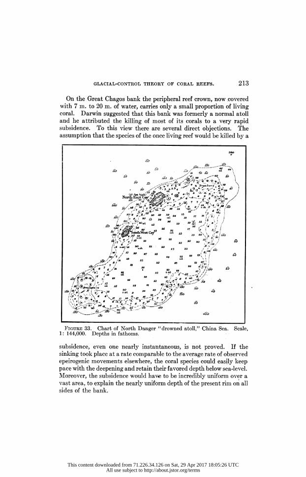
GLACIAL-CONTROL THEORY OF CORAL REEFS. 213
On the Great Chagos bank the peripheral reef crown, now covered with 7 m. to 20 m. of water, carries only a small proportion of living coral. Darwin suggested that this bank was formerly a normal atoll and he attributed the killing of most of its corals to a very rapid subsidence. To this view there are several direct objections. The assumption that the species of the once living reef would be killed by a
Figure 33. Chart of North Danger "drowned atoll," China Sea. Scale, 1: 144,000. Depths in fathoms.
subsidence, even one nearly instantaneous, is not proved. If the sinking took place at a rate comparable to the average rate of observed epeirogenic movements elsewhere, the coral species could easily keep pace with the deepening and retain their favored depth below sea-level.
Moreover, the subsidence would have to be incredibly uniform over a vast area, to explain the nearly uniform depth of the present rim on all sides of the bank.
This content downloaded from 71.226.34.126 on Sat, 29 Apr 2017 18:05:26 UTCAll use subject to http://about.jstor.org/terms

214 DALY.
An easier explanation is found in the special weather conditions of this oceanic area. The hurricanes of the South Indian ocean often arise far to the east of the Chagos bank and sweep westward, creating tremendous seas, which attack the bank and stir its muddy surface. The region is also visited annually by more ordinary storms, in number unusual for most tropical seas. Danckelman states that this part of the Indian ocean has an average of 119 days of heavy weather ("Ge wittertage ") every year, while the sea 35-40? farther south has a corresponding average of only 15 days.46 If the occasional hurricane stirs the mud so thoroughly as to kill off most of the corals, the surf must succeed in cutting down the top of the atoll reef, no longer de
\"ri /? 22 ?? 24 24 ** \^ >x,? /? to! * .a *4 w \? i&y?z ,M? jjrr ,r I7\248
a.vTi 24 *? ?a >'o >s /' * /fl * d ' \ .
<J ? _- 24 ?^ -. 25 29 ** ,0 23 23 \ x 25 26 ? 24 24 25 23 \*<> " 23 \20 f*
*?40 2, 25 ?- ? 24 24 ..- ^ J9?'" 26 ~ 24 24 ? 2z t/^\v 25 24 2S 27 24 " *' \(? >^
237 "?- " SCT,2S24 25 -T" ? " ? ? 2>s* /*> 3/ ? 25 22 2? 2? 25 26 Z7 i""- ? ? ?/? ? ? ? " ? ? ? 'T^
s.?rt **.V 22 ?-o- wsn._'P
Figure 34A. Turpie bank, north of the Fiji group. This bank is only partly rimmed, yet shows nearly the same depth of water as that in the lagoons of Penguin or Alexa bank (Fig. 34B). Such close agreement, like the flatness of each platform, is difficult to explain on the subsidence theory. Scale, 1: 307,000. Depths in fathoms.
46 See 0. Kr?mmel, Handbuch der Ozeanographie, Stuttgart, 1, 321 (1907). According to C. Darwin (Coral Reefs, London, 3rd ed., p. 40 (1889)), the sea is sometimes discolored with sediment washed out of the entrances to the Chagos atolls. On pages 87 and 113 of the same book will be found his classic statements as to the fatal effect of sediment on growing corals.
This content downloaded from 71.226.34.126 on Sat, 29 Apr 2017 18:05:26 UTCAll use subject to http://about.jstor.org/terms

GLACIAL-CONTROL THEORY OF CORAL REEFS. 215
fended by a living bulwark. The surviving corals would reoccupy the abraded surface as fast as possible, making new increments, which in their turn wrould be subject to later successful attacks by the waves. This hypothesis is supported by the character and relative uni
formity of the depths on the rim. Depths of from 7 m. to 20 m. are exactly of the order expected under the conditions. Much of the sand and mud formed in the partial destruction of the reef must be thrown into the lagoon, and the broad terrace, adjoining the inside of the reef-rim and covered with about 30 m. of water, appears to have been thus formed.
The Pitt, Speakers, and Saya de Malha banks are under nearly the same climatic conditions as the Great Chagos. The China Sea and the open ocean washing the banks north of Fiji (named in the foregoing table), are famous for destructive typhoons. It seems reasonable to explain the submerged rims of all these crowned banks in the same way. (Figs. 34A and 34B.)
However, the correctness of the hypothesis now offered is not fully established until the normal, surface reefs of the Chagos archipelago (e. g., Diego Garcia) and of the Fiji group can be explained. The prob lem does not now seem to be capable of full solution. Factors other than those just enumerated are important and cannot yet be valued properly. Among them are : the prevailing, as contrasted with the oc casional, weather conditions; the kinds and numbers of reef corals at work in the respective seas; the protection exerted by central islands in the case of the Pacific barrier reefs ; the fetch of the hurricane waves ;
and the size of the platforms involved. The last-mentioned feature is doubtless quite important, since the density of the muddy clouds stirred up by waves is directly proportioned to the width of the plat form, as measured along the line in which the waves are running.
The Maldives are occasionally visited by hurricanes, coming from the Bay of Bengal. However, such storms are already much weakened by their passage across India or Ceylon, and the heavy swell generated in the bay itself can have little effect on the Maldive islands. Hence there is good reason for the abundance of flourishing surface reefs in this archipelago, though it lies so near the Chagos group.47
47 C. Darwin (Coral Reefs, London, 3rd ed., p. 50 (1889)) quoted Captain Moresby's observation that the southern atolls of the Maldives are more constantly exposed to a heavy surf than are the northern atolls. The most southerly of all, Addu, though only 14 km. long, has a maximum lagoon depth of about 70 m., and is thus much deeper than the other small Maldive atolls. Darwin remarks: "I can assign no adequate cause for this difference of depth" (page 47 of his book). Is it in part due to a more frequent killing of the Addu
morals, in post-Glacial time, by the stirring of lagoon sediments?
This content downloaded from 71.226.34.126 on Sat, 29 Apr 2017 18:05:26 UTCAll use subject to http://about.jstor.org/terms

2 ?' i? S/ ?^
? 'fu *! N -j^-.
. K K $ ,|g
;S *i *
fc>;?5
s ,4 *! '3?
* 5^ w
?^s 8 a?8
. ST..
5 i ft /"N ? (O 'S'-.OT
at J
- & '
?. i '' ** m /? ?g.' ;
!5 "?i i aL
%?1 a -.Vf
^ 6 ". 5V' ,1 <6 <D
-?>Y3 Si? 5/|K 'Ac? 5 * J.*
\5
..* ?
216
This content downloaded from 71.226.34.126 on Sat, 29 Apr 2017 18:05:26 UTCAll use subject to http://about.jstor.org/terms

GLACIAL-CONTROL THEORY OF CORAL REEFS. 217
A number of large banks in the coral seas have either no projecting reef rims at all or else have merely local raised patches of coral on their edges. Examples are here listed (Table V).
TABLE V.
Rimless Banks in the Coral Seas.
Extreme Maximum Average Length breadth depth Km. Km. M.
depth
Indian Ocean Seychelles (Fig. 18) 300 175 120 55-65 Amirante 170 55 60 45-50 Bassas de Pedro or 110 24 77 45-55
Padua (Fig. 37) China Sea
Prince Consort 25 13 81 64-72
These cases are more difficult of explanation. The Seychelles bank, for example, does not now lie in the path of frequent hurricanes, and, so far as the writer can find records, the Seychelles area has moderate weather the year around.48 Similarly, part of the Laccadive plat forms are provided with atoll reefs reaching the surface, while others are still flat banks lacking peripheral reef crowns. It is possible that the rimless banks not now lying in hurricane paths have been affected by hurricanes during some earlier fraction of post-Glacial time, as the climatic zones of the Pleistocene slowly shifted to their present posi tion.
The unrimmed banks above listed, as well as others within the tropics, have average depths of just the same order as those found on
many banks outside of the coral seas, e. g., the Tanner, Cortes, and Osborn banks off California. As already noted, such accordance finds no systematic place among the consequences of the subsidence theory, but is expressly demanded by the Glacial-control theory, if these intertropical banks have been little modified by post-Glacial growth of coral, and if sea-level has undergone little change since the
48 A. Voeltzkow (Geog. Anzeiger, Jahrg., Heft 1, p. 5 (1907)) states that, so far as he saw during his extensive travels, the whole western part of the Indian ocean is remarkably devoid of strong reefs composed chiefly of living corals, though limestones enclosing isolated corals do form banks. He speaks of the local patches of growing corals ("Koralleng?rten") as secondary forma tions, having no close relation (" ohne jede n?here Beziehung") to the platforms on which they rest.
This content downloaded from 71.226.34.126 on Sat, 29 Apr 2017 18:05:26 UTCAll use subject to http://about.jstor.org/terms

218 DALY.
late Pleistocene. That the depths are relatively great as compared with most lagoon depths, is at once largely explained by the failure of continuous reef growth, on which the post-Glacial aggradation of the platforms has so much depended.
Among the Solomon islands, Guppy found that the reefs either reached the surface or had 7 m. to 18 m. of water upon them. Reefs of intermediate depth were not found.49 His generalization suggests the necessity of a rather definite critical strength which must be sur passed if a reef is to keep its summit at sea-level. If its power of resistance to the waves falls below that critical point, the top of the reef is kept down to levels (?7 to?25 m.), wdiere the abrading surf can no longer conquer in the struggle with living coral and its allies. The exact causes for varying success in the ceaseless combat are here again not determined, and evidently mud-control is only one of many factors, which are quantitatively varying from place to place in the oceanic area.
Nevertheless, the clear possibility that mud-control really explains the Great Chagos and similar "drowned" atolls, seriously affects what Dana described as " one of the best demonstrations of the sub sidence theory/ '
Volumes of the Existing Reefs. According to the new theory, the living coral reefs rest on platforms prepared in the Glacial period, and thus, in general, rest on pre-Glacial sediments or volcanic rocks. The greatest thickness possible for these reefs is about 110 m., assuming an extreme amount, 75 m., for the rise of post-Glacial sea-level within the tropics. Usually the thickness would be less. Once more the theory can be tested quantitatively. The boring
at Funafuti showed massive coral to persist to a depth of about 46 m. Below that depth the log of the boring suggests that it passed through talus material all the way to the bottom, at a depth of 340 m. This conclusion was reached by the writer after a careful study of the Funafuti report, issued by the Royal Society of London; a subsequent inspection of a duplicate set of the core material has tended to confirm the opinion. Unfortunately, the hole bored in the lagoon at Funafuti was not deep enough to decide the nature of the rock beneath the lagoon detritus. As shown in a later section (page 247), the main bore at Funafuti, useful as it has been in clearing up many important points, was badly located for its primary purpose of testing the Darwin-Dana theory. A truly valuable test can be made by boring on a coral islet,
49 H. B. Guppy, Proc. Roy. Soc. Edinburgh, 13, 867 (1886).
This content downloaded from 71.226.34.126 on Sat, 29 Apr 2017 18:05:26 UTCAll use subject to http://about.jstor.org/terms

GLACIAL-CONTROL THEORY OF CORAL REEFS. 219
situated within the lagoon of a typical atoll, about midway between the main reef and the lagoon center. Among the more favorable locations is that at Breakfast (Fr?hst?ck) Island in the Jaluit atoll.
A second test is to be found in the thicknesses of open-ocean reefs which have been uplifted in the post-Glacial period. By the new theory they should never surpass 75 m. to 110 m. If the uplift has been great enough, the unconformity of reef and basement should be visible. After a fairly complete review of coral-reef literature, the writer is convinced that these theoretical consequences accord well with the facts so far published. That the existing reefs are mere veneers is the accordant testimony of Agassiz, Wharton, Semper, Gardiner, Guppy, and others of those who have studied recently elevated islands. Speaking of the Solomon group, Guppy wrote: " Amongst the numerous islands that I examined, I never found one that exhibited a greater thickness of coral limestone [i. e., true coral reef material in situ] than 150 feet [46 m.], or at the very outside 200 feet [61 m.j." 50 His statement in principle serves to express the view held by each of these experienced observers.
Again, the Glacial-control theory implies that the areal extent of the existing reefs must be small. Post-Glacial time is now proved to be quite moderate, of the order of 20,000 to 50,000 years. Yet, if a period of 100,000 years measures more closely the life of many existing reefs, these still cannot cover more than very small portions of their respective platforms. As a matter of fact the dry land of the average great atoll totals less than one per cent of the platform area. The whole reef crown of such a typical atoll as Suvadiva totals only about 10 per cent of the platform area. Such proportions illustrate the youth of the existing reefs.
The lateral spreading of each reef is chiefly effected by growth of the corals at depths of 9 m. to 35 m., the increase being, however, much the more rapid on the open-sea side. If Gardiner's estimates of the rate of coral growth apply to the whole Recent period, the observed widths of the reefs would appear to demand from 20,000 to 50,000 years for their development. In other words, the widths as well as heights of the existing barrier and atoll reefs are of the proper size, if these cal careous rims originated on the platforms in post-Glacial time. (See Figs. 5-22, 38-43.)
Originating in very shallow water, reefs of the fringing class must have smaller average thicknesses than either barrier or atoll reefs.
50 H. B. Guppy, The Solomon Islands, London, p. 71 (1887).
This content downloaded from 71.226.34.126 on Sat, 29 Apr 2017 18:05:26 UTCAll use subject to http://about.jstor.org/terms

220 DALY.
A favorably placed fringing reef may have a width greater than that of a typical annular reef, but that cannot be true of shore reefs which are much troubled by invasions of mud. The observed widths of fringing reefs, including their maximum values, also agree with the implications of the Glacial-control theory. Therein the writer's initial problem ? an explanation of the youth of the Hawaiian reefs ? finds a solution. It is worthy of note that Darwin's recognition of the youthful appearance of atolls and other reefs, in both the Pacific and Indian oceans, was a leading reason for his invention of the subsidence hypothesis.51
Objections to the Glacial-control Theory.
The preferred explanation of coral reefs contains many elements involving definite quantities. These include : the actual temperature of the Pleistocene ocean; the volumes of water abstracted from the sea during the various maxima of glaciation; the effect of glacial attraction on tropical sea-level; the length of the whole Glacial period; the total duration of the greater ice-sheets; the power of Pleistocene waves; the rock-strengths and heights of the Pleistocene islands; the length of time since the late-Glacial warming of the sea; the loca tion and amounts of post-Glacial (Recent) deformation of the earth's crust underlying the coral seas; the growth rates of corals and of their reef-building allies; and the maximum and mean depths of reef lagoons, island shelves, and continental shelves. In a recent paper Davis has expressed doubts as to the validity of the new theory, on various grounds. Some of his reasons have to do with the quantita tive elements just noted, and may be first noted, along with related objections implied in other writings.52 Some repetition of statement is advisable, in the interests of clearness.
Glacial Lowering of Sea-level within the Tropics. "The maximum number of feet by which the sea-level was lowered may have been less than the amount above quoted (200 feet), because the depression of certain glaciated lands, like Labrador and Scandinavia, while ice sheets lay on them, was presumably compensated by an uplift of the neighboring sea floor, and that would have tended to raise the sea level." (Davis, p. 729.) The depression of these lands, if no greater than their post-Glacial uplift, would not affect the order of magnitude
51 C. Darwin, Coral Reefs, London, 3rd ed., pp. 43 and 69 (1889). 52 W. M. Davis, Bull. Amer. Geog. Soc, 46, 728-734 (1914).
This content downloaded from 71.226.34.126 on Sat, 29 Apr 2017 18:05:26 UTCAll use subject to http://about.jstor.org/terms

GLACIAL-CONTROL THEORY OF CORAL REEFS. 221
assumed by the present writer for the lowering of tropical sea-level. There is no evidence of a much greater depression of Labrador or Scandinavia during the Pleistocene. It is, further, improbable that the depression was compensated only by uplift of the sea bottom.
If the repeated assertion that an ice-cap cannot be more than 1,600 feet (488 m.) thick were true, the foregoing statement of the Glacial control theory would need essential changes. The reasoning on which the assertion is based, is theoretically faulty, and its conclusion impossi ble for any one who has seriously reflected on the plain facts of glacia tion either in the Canadian Cordillera or in the Laurentian-New England region of the east. Martin's recent proofs that in 1892 the Muir glacier had a local thickness of 750 m. and that in 1894 the Grand Pacific glacier was locally more than 900 m. thick, are good grounds for admitting the possibility of ice-caps which are 1,000 m. or more in thickness.
Restriction of Reef Corals by Pleistocene Cold. It has been doubted that the reduction of ocean temperature was sufficient to kill or greatly weaken the corals on most of the reefs. Until the last year or two, practically all supporters of the Darwin-Dana theory neglected to discuss this point, and assumed a tropical-sea temperature con tinuously favorable for coral growth. Dana held that the coral-reef period "probably covered the whole of the Quaternary." 53 The assumption is clearly unwarranted by the facts now known concerning Pleistocene climate, north and south of the equator. The burden of proof is really on those who hold that the winter sea temperature of the coral-reef areas was not 5? to 10? C. lower during the Glacial period than it is now.
General Crustal Stability in the Coral-sea Areas. Upholders of the subsidence theory will naturally question that the ocean floor has been undisturbed for a time long enough for the preparation of the reef platforms by erosion and deposition. According to the new theory, most of this work was done in pre-Glacial time. The work demands much of the later Tertiary, as well as the Pleistocene period, and thus, during several million years, the relation of sea bottom and sea surface was not significantly changed. However, such crustal stability is necessarily postulated only for the parts of the coral-sea areas where broad platforms, about 75 m. below sea-level, are now found. For those areas the assumption of prolonged crustal stability, except for minute oscillations, seems absolutely unescapable. All theories of
53 J. D. Dana, Amer. Jour. Science, 30,169 (1885).
This content downloaded from 71.226.34.126 on Sat, 29 Apr 2017 18:05:26 UTCAll use subject to http://about.jstor.org/terms

222 DALY.
coral reefs must recognize it. As already noted, the presence of a wide shelf or bench, a few tens of meters below sea-level, really represents a criterion for crustal stability during the later geological periods, generally including at least the time since the mid-Pliocene. The existence of the broad plateaus, their accordant relation at present sea-level, and the impossibility of explaining them by any cause other than prolonged marine action, are the supreme facts emphasized in this paper. The weakest element in the subsidence theory is its failure to take proper account of them.
Perfect crustal stability in the intertropical zone during the Pleisto cene and Recent periods is obviously not implied in the Glacial control theory. Ample illustration of local uplift and subsidence in the coral seas has been given. Yet a comparison of Table III with the charts of reef areas in general shows the exceptions to prove the rule of an essential lack of important crustal deformation in those parts of the ocean, since the beginning of the Pleistocene. The fact that the Pliocene beds of California and other regions are strongly folded, or the fact that certain continental areas have undergone considerable warping since the mid-Pliocene, may incline some geologists to doubt the postulate of crustal stability for the sea floor during the same in terval of time. However, a serious appeal to the diastrophic record of the continents can have no other effect than to showr their general freedom from strong warping since the mid-Pliocene. So far as a parallel between continental and oceanic areas may be drawn, it merely corroborates the idea of widespread crustal quiet in the sub marine crust. As a result of studying Californian or other mountains, one cannot forecast crustal behavior in the middle of the Pacific, nor, from Pliocene upwarps in the Alps, can one deduce recent subsidence in the Maldive-Chagos region of the Indian ocean. Dana's own theory of great antiquity for the ocean basins tends to forbid such a priori reasoning. While the Glacial-control theory fully recognized local diastrophism,
as well as general crustal quiet, in the coral-sea areas during late geo logical time, the Darwin-Dana theory seems to allow no place in them for a stable sea-floor during the same period. If that floor, anywhere in the reef regions, was not moved since the early Tertiary, the surface reefs should there be much wider than in the areas supposed to be sinking. No such unusual reefs are to be found in the charts. That there has been no stable place in the coral seas is surely harder to believe than the view that a general still-stand of the sea bottom in 1 ate geological time cannot be assumed, simply because there has been recent diastrophism in the continents.
This content downloaded from 71.226.34.126 on Sat, 29 Apr 2017 18:05:26 UTCAll use subject to http://about.jstor.org/terms

GLACIAL-CONTROL THEORY OF CORAL REEFS. 223
Sea-cut Platforms and Drowned Valleys Outside the Coral Seas. The Glacial-control theory implies a lowered wave-base and a lowered base-level for rivers during much of the Pleistocene period. The objection has been offered that the expected topographic effects are not visible in extra-tropical regions. A reply to the objection is to be found in the world's maps and charts. More than twenty years agor Penck recognized the abundance of drowned stream valleys along coasts which have not been glaciated or uplifted in Recent time. He referred this widespread phenomenon to a general rise of sea-level and found the cause of the rise in the melting of Pleistocene ice, as several other authors had stated before him. To the same cause he attributed the development of the "Flachsee," which rims the conti nents and larger islands.54 The general failure of geologists to follow Penck's lead seems to be due to over-emphasis on crustal subsidence as a cause of positive movements of sea-level along shore lines. In many modern works no other condition for positive movements is even mentioned. Examples are plentiful in the state survey and other papers dealing with the Pleistocene and Recent geology of the Atlantic States south of New York.
The many buried rock-channels of the Thames, Cam, Tawe, Neathe, Wye, Severn, Avon, Dart, Towy, and other rivers in England and Wales, like those found beneath the estuary muds at Milford Haven, Plymouth, and Falmouth, have depths of the order required, if these channels were cut during the Pleistocene time of lowered sea-level.55 The Recent submergence of the Dogger bank in the North Sea has been correlated with the drowning of the British valleys.56 Other cases of Recent drowning to the same moderate degree are abun dantly described in the literature concerning the Atlantic coast from Maryland southward.57 Erosion while the level of the Gulf of Mexico was Glacially lowered, may well account even for the buried channel of the lower Mississippi.58 To turn to the other side of the world, Andrews and others state that the New South Wales coast
54 A. Penck, Morphologie der Erdoberfl?che, Stuttgart, 2, 580, 658-660 (1894).
55 W. Whitaker, Quart. Jour. Geol. Soc, 46, 333 (1890); T. Codrington, ibid., 54, 251 (1898), and 58, 35 (1902).
56 A. S. Kennard, in discussion of J. W. Stather's paper, Quart, Jour. Geol. Soc, 68, 327(1912).
57 See particularly G. B. Shattuck's volume on the Pleistocene and Pliocene deposits of Maryland, published by the Maryland Geological Survey (1906).
58 See J. Leconte, Elements of Geology, New York, p. 558 (1892).
This content downloaded from 71.226.34.126 on Sat, 29 Apr 2017 18:05:26 UTCAll use subject to http://about.jstor.org/terms

224 DALY.
shows a positive shift of level to the extent of about 60 m., since the Tertiary.59
In fact, the more carefully existing coast lines are studied, the more apparent is the correctness of Penck's generalization and the more unavoidable is the hypothesis that most of the world's drowned valleys were submerged because of a Recent, general rising of the ocean's surface.
Drowned Valleys of the Coral Islands. Many volcanic islands sur rounded by barrier reefs have partially drowned erosion valleys. Dana regarded such valleys as proofs of crustal subsidence and Davis has adopted the same view. Some of the island embayments may be correctly explained in this way. For example, New Caledonia and the Fiji archipelago are generally regarded as located in a region of continental fragmentation. During the Tertiary period the eastern part of the Australasian continent was much faulted and otherwise deformed; the already dissected region sank below the sea and many valley bottoms became covered with water, scores or hundreds of meters in depth. Such submerged portions of the valleys were par tially filled with detritus and shelly material. In some instances, abundance of mud doubtless prevented the sealing of the bays by coral growths. The outer stretches of these bays were thus subject to aggradation by waves coming in directly from deep water. The aggraded parts of the bays would have depths of from 20 m. to 50 m. below the sea-level of that time. Very slight additional erosion during the Glacial period, when sea-level was lowered, would be necessary to account for present depths below sea-level. Farther up the bays, the weak materials of the Tertiary deltas were attacked by the Pleis tocene waves and the sediment thus stirred was dragged out into deep water by currents, both tidal and wind-driven.
Many of the Fijian and other islands have been uplifted since the time of continental fragmentation; their Tertiary drowned valleys were similarly subject to cleaning-out by marine action during the Glacial period.
Drowning of the resurrected valleys is a final, expected result of the late-Glacial rise of sea-level. (See also page 227.) However, a similar explanation cannot be admitted for most of
the coral archipelagoes. These lie outside of the Fiji-New Caledonia
59 E. C. Andrews, Proc. Linn. Soc. New South Wales, Part 3, p. 786 (1903); C. A. S?ssmilch, An Introduction to the Geology of New South Wales, Sydney, p. 153 (1911).
This content downloaded from 71.226.34.126 on Sat, 29 Apr 2017 18:05:26 UTCAll use subject to http://about.jstor.org/terms

GLACIAL-CONTROL THEORY OF CORAL REEFS. 225
area, where evidences of crustal uneasiness during the later stages of the Cenozoic are independent of the drowned-valley criterion.
As shown by the charts, island embayments of the class here con sidered have everywhere depths no greater than those anticipated if the bays are due to suba?rial erosion during the Pleistocene time of lowered sea-level. In spite of aggradation by waves and currents, it seems inevitable that a few of the larger valleys should have greater depths, if their drowning were caused by crustal sinking in the Recent period. The failure of these greater depths tends from the first to weaken Dana's criterion.
According to the subsidence theory, the still unsubmerged portions of the valleys should be of the one-cycle type, unless post-Glacial sinking were too slow for the complete submergence of the sides of the inner valleys which were excavated below the Tertiary floors because of the lowering of base-level in the Glacial period. According to the Glacial-control theory, the drowned valleys in general should be of the two-cycle type, or should have been of that type at some stage since the first climax of glaciation.
In attempting to test the two theories by the use of this principle, it must be remembered that in volcanic islands a broad erosion valley is not necessarily as old as an equally broad valley cut in non-volcanic rocks. Observers in the Hawaiian islands, for example, cannot fail to be impressed with the breadth, as well as depth, of obviously youth ful valleys cut in the volcanic formations. An abundant development of amphitheatres and broad troughs is an early result of suba?rial attack on the typical volcanic island. The causes for such abnormal physiographic development are not wholly understood. One of them may well be a special tendency to caving or landsliding along the walls of young valleys cut in volcanic masses. The latter are characteristi cally interrupted by zones of weak ash-beds or weak scoriaceous phases of the lava flows ? layers liable to water-soaking, with consequent danger of landslides. A second cause for rapid slumping is found in the unusual prevalence of vertical joints in massive lavas. Widen ing of the Pleistocene gorges cut in the central islands may therefore be more pronounced than in the case of gorges simultaneously cut in continental rocks. Whatever be the reasons, valley-making in vol canic islands gives results somewhat different from those usual in typical areas of the continents. The physiographic processes operat ing on the oceanic volcanoes certainly need thorough study. At least until that is accomplished, it is not advisable to apply the continental chronometer to the islands. There, many broad valleys seem to be
This content downloaded from 71.226.34.126 on Sat, 29 Apr 2017 18:05:26 UTCAll use subject to http://about.jstor.org/terms

226 DALY.
young valleys ; a relatively broad bay may not be a drowned " mature " valley, if by that term is meant a valley of great absolute age. The point specially worthy of note is that one can not, in these cases, safely locate the original bottom of each drowned valley at the inter section of the visible valley slopes, simply prolonged without essential change of angle to the horizontal plane. When the sea-level of the coral seas fell, during the first Glacial
climax, the floors of the broader stream valleys were trenched by the now revived streams. An " edge," " shoulder," or break of slope was then formed where the Tertiary floor met the top of the incised Pleistocene trench. Assuming no crustal movement, this "edge" was a few meters higher than the present sea-level, and at first sight it seems necessary to expect the break of slope to be visible to-day. The failure to find such valley-in-valley remnants in the present topog raphy of certain Pacific islands has led Davis to doubt the Glacial control theory. Yet, if the inner valley were essentially completed during the early,
Kansan stage of glaciation (probably the time of maximum ice in North America at least), it is unlikely that the "edge" would still be generally, if at all, preserved. Post-Kansan time has been long enough for the mature dissection of the Kansan drift. The rock-material forming the "edges" of inner valleys must have been somewhat weak ened by weathering; otherwise no "edge" would have been devel oped, since the widening of such valleys depends on the preliminary weathering of the rocks in the valley sides. Post-Kansan time, fav ored by the rapid rock-decay and heavy rains characteristic of the tropics, seems long enough to have largely or quite obliterated such minute features as these valley-in-valley " edges."
Upstream, each revived river or creek must have speedily cut a distinct, narrow gorge in the floor of the Tertiary valley, just as the rivers of England and many other countries have cut young gorges during the Pleistocene. Those gorges should still exist, but, in general, they must be largely filled with post-Glacial alluvium and be thus invisible at the present surface. That the Glacial period was long enough for the excavation of inner
valleys 50 or 60 m. deep, is not an extravagant assumption. If the Antarctic ice-cap, the last surviving one of great size, was also the first to form, the axial parts of the valley floors of the islands, except the lower stretches now submerged, have suffered suba?rial erosion during a period longer than all Kansan and later time.
Reviewing the criterion, it appears, first, that some bays of central
This content downloaded from 71.226.34.126 on Sat, 29 Apr 2017 18:05:26 UTCAll use subject to http://about.jstor.org/terms

GLACIAL-CONTROL THEORY OF CORAL REEFS. 227
islands in the western Pacific are explained by the sinking of those islands. However, the dating of that subsidence is not yet established, and the actual bays may be due to the Pleistocene cleaning-out of unconsolidated sediments which had been deposited in valleys, drowned during the Tertiary fragmentation of the Australasiatic continent. Secondly, the Glacial period was long enough for some further deepening of the Tertiary valleys by suba?rial erosion. Well marked "edges" of the resulting valley-in-valley topography should not appear generally in the central islands of the present day, if the " edges " were formed early in the Glacial period. Thirdly, the narrow rock gorges cut at the heads of the bays should be more or less com pletely covered by post-Glacial alluvium.
The drowning of stream valleys is not the only cause for embay ments. In each case it must be determined whether the bay is due to irregular accumulation of volcanic products, to faulting, to volcanic explosion, or to erosion. In many instances the bays are clearly en axe with valleys cut by streams and are so located because of pre liminary suba?rial erosion. However, such bays may not all represent river valleys submerged by change of sea-level. Ocean waves usually tend to smooth continental coast-lines, faced by broad submarine shelves. The shelves have a double office. They furnish shallow platforms on which coastal detritus may be quickly aggraded to sea level; and they lower the erosive energy of the surf by partly wearing out waves from the open ocean. Smoothing of a coast-line is a direct function of offshore aggradation. As the latter is delayed because of great depth of water, the waves have a longer time to search out the weak places in the land mass attacked. The more steep-to the coast, the more powerful are the attacking waves. In both respects undefended volcanic islands, with very deep water close to their shores, are subject to specially rapid searching by the waves. Now the very existence of a main valley in a Pleistocene island implies that its flooring rocks were already somewhat weakened by weather ing. The volume of rock above sea-level, per unit length of shore line, was smallest at the intersection of the shore line with the valley floor. For two reasons, therefore, the surging breakers must have tended to cut bays in the Pleistocene islands, just as they are now cutting bays in the Algerian coast, in some parts of the North Atlantic coast, in Christmas island (Indian ocean), and elsewhere.60
60 See T. Fischer, Petermann's Geog. Mitt., p. 1 (1887); C. W. Andrews, Geog. Jour., 13 (1899) (map of Christmas island).
This content downloaded from 71.226.34.126 on Sat, 29 Apr 2017 18:05:26 UTCAll use subject to http://about.jstor.org/terms

228 DALY.
Central-island bays of this origin are probably shorter and less con spicuous than those due to the drowning of stream-erosion valleys, but are none the less worthy of attention by the student of shore topography.
Again, as noted on page 162, a complete analysis of the bay problem must take account of the possibility of a Recent shift of sea-level, owTing to causes other than the melting of glaciers. Post-Glacial uplift of the sea floor, over extensive areas, has been proved. If it has not been wholly compensated by sinking of the ocean bottom elsewhere, a general rise of sea-level occurred in post-Glacial time. Such a positive movement would tend to drown the valley-in-valley u edges," the Pleistocene shore cliffs, and allied topographic features. A post-Glacial rise of a few meters is quite possible as the result of diastrophic processes.
On the other hand, the level of the ocean to-day cannot be many meters from its position in the Pliocene period. (See page 198.) That conclusion follows from the facts expressed in the charts of the continental shelves. Whatever may be the shapes of the rocky terranes beneath the shelves, the surface of each shelf has surely been smoothed and greatly widened by waves and currents. Each repre sents an embankment growing, like a delta, into deep water. Normal storm waves and ocean currents effectively transport bottom mud if the depth of water is 75 m. to 40 m. or less. Depths of 75 m. to 40 m. prevail in the outer half of each of the wider shelves throughout the ocean. The building out of the great embankments to their actual widths demands all the time from at least the mid-Pliocene to the present day. The continental shelves seem, therefore, to indicate nearly the same position for sea-level during the later Tertiary as for post-Glacial time. The Pleistocene shifts of level represent a com paratively brief interlude, and there is no evidence that the major shifts of that period were essentially caused by any other process than glaciation and d?glaciation. ^Finally, the absolute proof of bay-making by Recent subsidence would not establish general subsidence for all areas characterized by barrier reefs or atolls, nor would it invalidate the Glacial-control theory. Recent warping or faulting of the earth's crust, in moderate amount, is an obvious fact in the Fijis, in the Tonga archipelago, in New Caledonia, in Oahu of the Hawaiian group, and in some other oceanic localities. The elevated strand-lines of the uplifted parts have correlatives in the drowned valleys of the sunken parts. As above noted, the Pleistocene platforms have been simultaneously
This content downloaded from 71.226.34.126 on Sat, 29 Apr 2017 18:05:26 UTCAll use subject to http://about.jstor.org/terms

GLACIAL-CONTROL THEORY OF CORAL REEFS. 229
warped up or dowm, and the suba?rial and submarine topography of the islands in warped areas have been accordingly explained. More over, it will be noted that a moderate sinking of the surface of a central island does not necessarily imply subsidence of the earth's crust beneath. (See page 233.)
Hence, several lines of reasoning show the grave danger of error in regarding drowned valleys as proofs of the general crustal subsidence postulated by Darwin and Dana for all barrier reefs and atolls. Ex cept in regions showing deformation in Tertiary time, the present depths of the corresponding bays are no greater than those expected as the result of erosion in the Pleistocene time of lowered sea-level. Therewith a measure of positive support is given to the Glacial-control theory. Vastly more compelling is the assemblage of facts regarding the bathometry of barrier lagoons and of atolls. The whole physiog raphy of reef-covered areas, both below and above sea, must be con sidered in attaining a just estimate of the problem. Ninety-nine per cent of that physiography is submarine and it does not accord with the Darwin-Dana theory. In the writer's opinion, a few scores of drowned valleys in an admittedly unstable part of the western Pacific are far less worthy of emphasis; they can hardly be held to prove general crustal subsidence in the coral seas.
Pleistocene Cliffing of Oceanic Islands. Objection has been raised to the new theory, on the ground that it does not agree with the observed topography of the shores between the bays of central islands. If platforms as extensive as the Maldive or Macclesfield banks were planed off by Pleistocene waves and currents, it is held that central islands generally should show strong cliffs at the shore ends of the erosion spurs. As a matter of fact, many of these islands are more or less cliffed. Sometimes the cliffs reach scores of meters in height, though usually the cliffs at the ends of spurs are only a few meters high.61 That they are not often much higher would be a strong argument against one phase of the Glacial-control theory, if the Pleistocene islands were all of the same height and rock-strength. Their great variability in each of these respects has been described. The Pleistocene waves must have cut wide benches in the pre-Glacial mud banks, shell banks, and banks of loose volcanic d?bris. Just as clearly they have made little impression on the lavas of Hawaii or Tahiti.
61 For many examples see the splendid series of photogravures illustrating Agassiz's various expeditions to the Pacific archipelagoes.
This content downloaded from 71.226.34.126 on Sat, 29 Apr 2017 18:05:26 UTCAll use subject to http://about.jstor.org/terms

230 DALY.
Consider the case of a late-Tertiary volcanic island, of normal type, composed of massive flows, with some interbedded layers of ash. Before the shore became well protected by growing corals, it was subject to some cliffing, a narrow bench being cut in the lavas. Out side the rock bench was a narrow shelf constituted of the detritus washed from the land by streams and waves. On this composite terrace the corals settled, and, with the development of a fringing reef,, the waves were no longer able to attack the island successfully.. The killing of the corals in the Glacial period caused a resumption of wave benching. The sea-level being then 50 m. to 75 m. or more lower than before the ice-caps were formed, the waves quickly benched the outer part of the terrace but soon discovered the hard lava underlying the terrace detritus. Thenceforth cliff recession must have been not only slow but increasingly slower, since the cliff grew higher as the line of surf advanced into the gently sloping volcanic foundation. Assuming the sea-level to have been then constantly 55 m. below its present position, the height of the sea-cliff would have to be more than 55 m., if any of that cliff should be now visible. The recession of the cliff to the point where it was 55 m. high might well occupy most or all of the time during which the sea-level had nearly its maximum depression. If the volcanic spur w^as cliffed to a greater height, post Glacial weathering and washing might have much softened its crest, a few meters above present sea-level. Of course, the greater part of each Pleistocene sea-cliff, now below
sea-level, is buried by post-Glacial detritus and reef material. Such a buried cliff, more than 20 m. high, has been demonstrated by borings through the coral reef and underlying mud at Brandy Bay,. Sumatra. The cliff rock there is andesitic.62
The Tertiary sea-cliffs of the imagined island were subject to wast ing through all the time following the original development of coral reefs on the island; that is, from the late Tertiary, or earlier, to the present day. Those cliffs would be expected to have been much softened in contour, if not wholly extinguished as distinct facets, before the present epoch.
In general, the volcanic islands exist because they are composed of rocks that are relatively resistant to the weather and to wave abrasion. Their existence, as well as the usual absence of very high spur-cliffs, merely shows that the Glacial period was of limited duration. On the other hand, atolls give no direct evidence as to its duration. If
62 C. P. Sluiter, Petermann's Geog. Mitt., 1891, Lit. Ber., p. 46.
This content downloaded from 71.226.34.126 on Sat, 29 Apr 2017 18:05:26 UTCAll use subject to http://about.jstor.org/terms

GLACIAL-CONTROL THEORY OF CORAL REEFS. 231
the new theory is correct, the atoll platforms were probably not the loci of pre-Glacial atolls. There is, in fact, no apparent reason for holding that great atolls or barrier reefs ever existed in pre-Pleistocene time. The extent of the massive coral reefs in the Pleistocene islands cannot be definitely stated, though in no case may it have been many times greater than, for example, that of the fringing reef at Rodriguez island in the Indian ocean. (See Fig. 28.) In any case it is unwise to assume that massive reef-rock or any other strong rock capped the whole of any Pleistocene island, which was truncated to form the wide flats bearing the present atoll reefs.
In conclusion, the quantity of wave-benching implied by the Glacial-control theory does not appear to represent a fatal objection to that theory, if the varying nature of the Pleistocene islands and shoals is well appreciated. Biology of Oceanic Islands. Another published objection is that
the existing faunas and floras of the oceanic islands do not accord with a theory involving general crustal stability for the ocean floors during the later geological periods. However, the literature of biogeography shows such a diversity of opinions on this subject that the criterion cannot be fairly described as now having any decisive value. Darwin, Hooker, Salvin, Griesbach, Engler, M. Wagner, Wallace, Peschel, Wolf, A. Agassiz, Steams, Heller, Dall, and F. X. Williams have con cluded that the organisms of the Galapagos islands are not such as to necessitate belief in a former connection of this purely volcanic archi pelago with any continent. Baur, H. Milne-Edwards, Von Ihering, and Van Denburgh, after their biological studies, thought best to assume a former connection with South America. Inasmuch as sharp divergence of views affects one of the best known island groups, any definite opinion regarding the origin of island species throughout the wide coral seas can still have but little value. Consensus among the expert investigators is reserved for the distant future. The lit tle that is known about the matter does not appear to weaken the Glacial-control theory, nor to support the subsidence theory, as ap plied to coral reefs in general.
Difficulties of the Subsidence Theory.
A discussion of all published hypotheses concerning the reefs will not here be undertaken. Murray's solution theory, formerly re garded with favor by leading investigators, is now seen to be weak on the quantitative side and is discounted by recent discoveries in typical
This content downloaded from 71.226.34.126 on Sat, 29 Apr 2017 18:05:26 UTCAll use subject to http://about.jstor.org/terms
232 DALY.
lagoons. However, certain features of the popular subsidence theory may be reviewed, in order to show more clearly the special advantages of the Glacial-control theory, the only other one involving Recent change of sea-level within the tropics. Here again discussion will be facilitated by a certain amount of repetition in presenting salient facts.
Its Alternative Statements. It is important to observe that the Darwin-Dana theory is not the only explanation through subsidence. The view of those famous authors is illustrated in the following passage, taken from the last (1895) edition of Dana's "Manual of Geology," page 350. Taking the Pacific area of reefs as a type, he wrote : " If, then, the atolls are registers of subsidence, a vast area has partaken in it ? measuring 6,000 miles in length (a fourth of the earth's cir cumference), and 1,000 to 2,000 in breadth. Just south of the line there are extensive coral reefs; north of it the atolls are large, but they diminish toward the equator, and mostly disappear north of it; and, as the smaller atolls indicate the greater amount of subsidence, and the absence of islands still more, the line AA [of his map of the ocean]
may be regarded as the axial line of this great Pacific subsidence. The amount of this subsidence may be inferred, from the soundings near some of the islands, to be at least 3,000 feet. But as 200 islands have disappeared, and it is probable that some among them were at least as high as the average of existing high islands, the subsidence in some parts cannot be less than 5,000 feet. This sinking probably began in the Tertiary era."
In postulating a general, prolonged sinking of parts of the sea bottom, each 10,000,000 to 25,000,000 square km. in area, Darwin and Dana agreed. As to one leading point the principles of their books do not agree. Darwin indicated the possibility of one or more con siderable pauses in the subsidence; Dana seems not to have considered that suggestion as worthy of emphasis. The necessity of assuming at least one very long pause, if the Darwin-Dana theory is to with stand even preliminary criticism, will be noted in succeeding pages.
But Gerland offered a very different version of the subsidence theory. According to him, the coral reefs do not show sinking of wide continuous areas of the ocean floor, but do show the independent sinking of each island mass ("Sockel"). In each case the subsidence is quite local, but has taken place at thousands of different points.63
This idea is worthy of attention. Nearly all of the oceanic islands and
63 G. Gerland, Beitraege zur Geophysik, 2, 56 (1895).
This content downloaded from 71.226.34.126 on Sat, 29 Apr 2017 18:05:26 UTCAll use subject to http://about.jstor.org/terms

GLACIAL-CONTROL THEORY OF CORAL REEFS. 233
shoals seem to be of volcanic origin. Rising from a sea bottom, 3,000 m. to 7,000 m. deep, each volcano is very high in absolute measure and is also of notable area. The local extravasation of so much lava may well entail local, moderate sinking of the earth's crust. It is, indeed, possible that such sinking is very often caused directly by volcanic action on a large scale.64 More certain is the fact that, after a great volcanic cone is formed, its upper and central part tends to subside. Probably owing to the slow compacting of its deeper tuffs and vesicular flows, as these are gradually heated and so softened by the magma of the central vent, the mass slowly settles. The loss of connate water in the deeper ash-beds, both because of the heating and because of mere dead-weight, is another cause for settling in a local area, below the highest part of the volcano. Actual subsidence of this kind is exemplified in the "volcanic sinks" located at many central vents of the first rank.65
Possibly, therefore, some of the drowned valleys and other physio graphic features showing submergence of volcanic islands are to be explained by local sinking to the extent of a few meters or a few scores, of meters. Clearly such subsidences would have very different geological dates, according to the respective times of preliminary volcanism. Erosion valleys so drowned in pre-Glacial periods would be filled, below sea-level, with sediment, which would be cleaned out again by the Pleistocene waves. Conceivably, some broad bays in the existing central islands may have thus originated. However, Gerland's version of the subsidence theory does not
account for the essential contemporaneity of the present atoll, barrier,, and fringing reefs. That they have been developed nearly or quite in the same interval of time is shown by their sectional areas and their volumes, as measured, in each case, above the break of slope at the platform on which the crowning reef stands. If the simultaneous submergence of coral islands in general were really due to crustal subsidence, the Darwin-Dana postulate seems to represent the only possibility. Their view is the one now to be briefly examined.
Uniformity of the Assumed Subsidence. As just hinted, the surface outcrops and volumes of the greater barrier and atoll reefs, measured from the levels of the lagoon floors, are respectively nearly equivalent in the Pacific and Indian oceans and in the neighboring seas. If these reefs were formed by subsidence, the earth's crust must have sunk at
64 R. A. Daly, Igneous Rocks and Their Origin, New .York, p. 185 (1914). 65 R. A. Daly, ibid., p. 150.
This content downloaded from 71.226.34.126 on Sat, 29 Apr 2017 18:05:26 UTCAll use subject to http://about.jstor.org/terms

234 DALY.
a nearly uniform rate, throughout the enormous area described. Since all large-scale crustal movement, which has become well under stood, is differential ? one part of a crust block moving faster than other parts, the Darwin-Dana theory faces another strong antecedent objection. Their postulate also fails to account for the approximate equality of volumes characterizing the typical atoll crown and the typical fringing reef, each volume being measured above the break of slope at the platform. One can hardly assume that all coasts fringed with reefs have sunk in recent geological time at the rate supposed to explain the atolls; nor that most fringing reefs are located in rising areas. Somewhere or other, an area of essential stability must exist in the coral-sea region; and there, according to Darwin himself, the breadth of the fringing reef should be much greater than that of a normal atoll or barrier reef.66 This consequence is not matched with fact.
Alleged Proofs of Current Subsidence. So far as the writer has been able to cover the literature, no case is recorded where a region bearing an atoll or barrier reef has been shown, beyond question, to be now visibly sinking. At least some of the instances cited by Darwin and others have not survived destructive criticism. This fact does not disprove his theory, but it annuls one of the positive arguments put forward in support of the theory. Even if local current subsidence were demonstrated, the Darwin-Dana theory would not be specially favored, for local sinking, like local uplift, is to be expected on any theory.
Darwin's related argument, derived from the " drowned " condition of the Great Chagos and other atolls, has already been discussed (page 213). It falls to the ground if the phenomenon is due to hurri cane action and mud-control.
Permanence of the Pacific Basin. Dana was a leading advocate of the antiquity of most of the depressions occupied by the present ocean.
Many specialists in geological dynamics favor that view, at least as far as the Pacific basin is concerned. Assuming great antiquity for the Pacific basin, the Darwin-Dana explanation of its reefs implies a unique, or almost unique, behaviour of the intertropical part of the basin in recent geological time. The narrowness of the atoll reefs is interpreted as meaning relatively rapid sinking. According to each of the two authors, the floor of the reef-covered Pacific has sunk thousands of feet within a period which is probably not equal to 5
66 C. Darwin, Coral Reefs, London, 3rd ed., p. 43 (1889).
This content downloaded from 71.226.34.126 on Sat, 29 Apr 2017 18:05:26 UTCAll use subject to http://about.jstor.org/terms

GLACIAL-CONTROL THEORY OF CORAL REEFS. 235
per cent, of recorded geological time. Clearly, similar sinking could not have occurred often in the same area, during the remaining 95 per cent of that record. No reason for specially great and rapid subsidence since the beginning of the "coral-reef period" (early
Miocene?) has yet been given. If this late sinking were actually preceded by many similar ones in the same area, during pre-Cambrian and later periods, one must assume intervening epochs when the sea bottom was upheaved; so that the final depth of the ocean should be no greater than it actually is. Rhythmic diastrophism of the kind and scale demanded is improbable. It should have left traces in the bottom topography of the Pacific, which, however, seems to be lacking in such evidences. The antiquity of a deep Pacific basin may be false doctrine, but,
so long as many facts continue to require its assumption, the subsi dence theory has to bear the heavy burden of explaining the recent character of the postulated sinking of the Pacific bottom. In less measure the difficulty also applies to the Indian ocean area of reefs.
High antiquity for the basin does not exclude its progressive deep ening, but the relative stability of most of its floor in the later Tertiary seems proved by the size of the larger reef platforms and other banks. In whatever way these plateaus have been formed, the process must have taken very much time, even measured by the geological scale. The Glacial-control theory holds that only the final touches in fashioning the platforms were applied during the Pleistocene. Banks of sand and mud and low islands of similar material or of weak
rocks were then truncated by the waves. During the relatively brief Glacial period, the sea bottom was so nearly stable as to permit of the wide benching of such banks and islands. The whole period was but a minute fraction of recorded geological time, and therefore is likely to have been one of general sea-floor stability, if the ocean basin dates from an early stage in the earth's history.
The problem is baffling because of insufficient data, but the conclu sion remains that the subsidence theory is at a disadvantage because of the difficulty of reconciling it with facts, independent of coral reefs and suggesting an immense age for most of the ocean basin.
Small Maximum Depth of Lagoons. Dana remarks that his theory " explains all the varying depths of lagoons, from the condition of near obliteration to that of a basin one to three hundred feet deep." 67 A few paragraphs beyond, he adds: "The coral-growing areas over the
67 J. D. Dana, Corals and Coral Islands, New York, 3rd ed., p. 272 (1890).
This content downloaded from 71.226.34.126 on Sat, 29 Apr 2017 18:05:26 UTCAll use subject to http://about.jstor.org/terms

236 DALY.
great lagoons of atolls and the barrier-bounded channels of the Feejees and other archipelagoes and those of the outer waters about islands or their barriers, show no tendency to grow with large depressed centres, but rather with flat tops, as vegetation might grow, or else with elevated centres.... It is only through continued subsidence under such conditions that the margins can be made to grow so much faster than the interior as to produce thereby a basin-like interior 50 to 300 feet deep."
It is strange that his recognition of only 300 feet (91 m.) as approxi mately the maximum depth of lagoons inside both atoll and barrier reefs did not lead Dana to question the subsidence theory more seri ously. Darwin did anticipate this objection and tried to meet it, as shown in the following passages: "Another and less obvious objection to the theory may perhaps be advanced, namely, that, although atolls and barrier-reefs are supposed to have gone on subsiding for a long period, yet that their lagoons and lagoon-channels have only rarely come to exceed 40 and never 60 fathoms in depth. But if our theory is worth consideration, we already admit that the rate of subsidence has not ordinarily exceeded that of the upward growth of the massive corals which live on the margins of the reefs, so that we have only further to suppose that the rate has never exceeded that at which lagoons and lagoon-channels are filled up by the growth of the delicate corals which live there, and by the accumulation of sediment. As the filling-up process, in the case of barrier-reefs lying far from the land, and of the larger atolls, must be an extremely slow one, wTe are led to conclude that the subsiding movement has always been equally slow. And this conclusion accords well with what is known of the rate of recent movements of elevation.
" And with respect to the whole amount of subsidence necessary to have produced the many atolls widely scattered over immense spaces, the movement, as already shown, must either have been uniform and exceedingly slow, or effected by small steps separated from each other by long intervals of time, so as to have allowed the reef-constructing polypifers to bring up their solid framework to the surface; and this is one of the most interesting conclusions to which we are led by the study of coral-formations." 68 Statements of similar import have not been discovered in Dana's book.
The multitude of new charts published since Darwin and Dana wrote their books, have essentially confirmed their generalization as
68 C. Darwin, Coral Reefs, London, 3rd ed., pp. 153-4 and 192-3 (1889).
This content downloaded from 71.226.34.126 on Sat, 29 Apr 2017 18:05:26 UTCAll use subject to http://about.jstor.org/terms
GLACIAL-CONTROL THEORY OF CORAL REEFS. 237
to maximum depths; it is not likely to be shaken by additional sound ing. Yet, if the great atolls are due to the sinking of correspondingly extensive islands, it is truly incredible that the lagoon depth should nowhere greatly exceed 300 feet (91 m.).
The subsidence in such a case has been estimated in terms of thou sands of feet. As the initial fringing reef was converted into a barrier and that finally into an atoll, the broadening lagoon waters must cover a kind of encircling moat between the central island or shoal and the upgrowing exterior reef. The reef speedily reaching the sea surface through most of its length, the wraves and currents of the open ocean can do very little toward aggrading the lagoon floor, which is little or not at all disturbed by any waves or currents generated in the
' lagoon itself. Some of the fragmental material flooring each lagoon is derived from the rimming reef. From the outer edge of that reef the heavy surf is constantly forming mud, sand, and loose blocks. Some of the detritus is thrown forward by the breakers, to compose reef islets or reef awash. A much greater proportion is dragged out into deep water.69 One often meets the statement that much material is washed over the reef into the lagoon, but obviously the amount so transported can be only a small part of the whole detritus. That fraction, together with material locally brought in through reef channels, must be deposited near the reef, for waves and currents inside the lagoon are usually powerless to move sand in water 40 m. or more in depth. Abrasion by the lagoon waves is very low. The resulting d?bris, of grain coarser than that of fine mud, is likewise deposited close to the reef. As stated in the Royal Society report on Funafuti (page 375) Sol?as observed that coral d?bris forms "but an insignificant part" of the "sand" (loose material) flooring that atoll lagoon, the chief constituents being foraminiferal shells and calcareous algae. In the extensive interior of the lagoon, any clastic material derived from the main reef is mud, with a little sand distributed by occasional great storms. The filling and smoothing-out of the hypo thetical "moat" about a subsiding island is evidently little*aided by this mud. The coarser detritus should form a well-defined terrace slowly growing inward from the reef. Such terraces would also be expected as a consequence of the Glacial-control theory; they are, in fact, conspicuous, though narrow, in Curtis's wonderful model of Funafuti at the Harvard University Museum. Their volumes are exactly of the order demanded if the reefs are of modern origin.
69 Cf. V. Cornish, Geog. Jour., 11, 530 (1898).
This content downloaded from 71.226.34.126 on Sat, 29 Apr 2017 18:05:26 UTCAll use subject to http://about.jstor.org/terms

238 DALY.
As the island, of normal profile, sinks, the land detritus rapidly diminishes in volume. The heads of the island deltas retreat farther from the " moat," so that its filling cannot be essentially attributed to outwashing from the central island.
The slowness of the filling-in process is further shown by the very common steepness of the inner reef slope (Fig. 35). Darwin speaks of such reefs as "like a wall." 70 Describing the Funafuti atoll, Gardiner writes: "The bottom of the lagoon, if the shoals were re moved, and the whole elevated, would be a great plain surrounded by a ridge sloping steeply up to a line of perpendicular cliffs broken only at the few ship's channels; on this plain the greatest heights would be from 20-30 feet." 71 In his great monograph on the Maldives, Gardiner describes the lagoon slopes of the reefs as "practically per-' pendicular" and elsewhere states that this fact "is not consistent with
0 50 100 200 400 T ' '_'
Figure 35. Section illustrating the common steepness of reef edges on the two sides.
the possibility of the lagoon's having been filled in by detritus washed over their encircling reefs." 72 Like many coral knolls dotting the lagoon floors, the inner edge of the main reef often shows soundings of 20 to 40 m., at very short distances from the reef edge visible at low tide. In such cases the rate of upgrowth for the living reef must have been greater than the rate of upgrowth for the sand terrace alongside. If the aggrading process is so inadequate at the source of supply, how much more inadequate is it to smooth the vast interior of the lagoon in any reasonable time! (See Fig. 36.)
As shown by the normal deepening toward the lagoon centers and by the sparseness of the coral knolls, pelagic shells, coral-knoll detritus, and bottom growths would be still less effective in filling the "moat"
70 C. Darwin, Coral Reefs, London, 3rd ed., p. 67 (1889) 71 J. S. Gardiner, Proc. Cambridge Phil. Soc, 9, 434 (1898) 72 J. S. Gardiner, Amer. Jour. Science, 16, 211 (1903).
This content downloaded from 71.226.34.126 on Sat, 29 Apr 2017 18:05:26 UTCAll use subject to http://about.jstor.org/terms

GLACIAL-CONTROL THEORY OF CORAL REEFS. 239
and smoothing the indefinitely varied floor of a lagoon surrounding a sinking island.
One must conclude that the filling of the " moats," so that nowhere they shall be covered with water more than about 90 m. deep, means an exceedingly slow rate of subsidence; one may doubt that the amount of aggradation, matching the known flatness of the lagoon floors, is a physical possibility even if that process occupied all Miocene and later time. But, on account of the narrowness of reefs, Darwin himself inferred a geologically rapid rate of sinking for them.73 The subsi dence theory therefore faces a serious dilemma, and none of its up holders has yet offered a reasonable explanation of the "extremely slow" (Darwin) filling-up process accompanying a rapid subsidence. Apparently the only conceivable way out of the dilemma is to assume
5 5 s D BANK
0 50 100 . 300 _ 600 ^
Figure 36. Section through a typical coral knoll in the "drowned atoll" Tizard bank, China Sea (after W. U. Moore and P. W. Bassett-Smith), show ing steepness of the knoll slopes and the distribution of corals. L, live coral; D, dead coral; S, sand.
that the filling of the "moat" occurred during a long pause in the sinking, while the narrow reef rim is due to a recent renewal of sub sidence. Since the atolls and barrier reefs of all the world have virtually the same features, it would follow that, throughout the greater part of the tropical Pacific, the Indian ocean, and the East Indian archipelago, there was a simultaneous, long-continued pause in subsidence; and that the pause was followed by a recent, rapid sinking to about the same amount, everywhere in the same world belt. The manifest improbability of the assumption shows the necessity of adding some other one, as yet unimagined, if the older theory is to account for the maximum depth of lagoons.74
73 C. Darwin, Coral Reefs, London, 3rd ed., p. 43 (1889). 74 Darwin did not believe that crustal movement could be uniform even
over the comparatively small area represented by the West Indian sea (C. Darwin, Coral Reefs, London, 3rd ed., p. 269 (1889)). How much more improbable is the view that the vastly larger Indian and Pacific areas occupied by atolls and barrier reefs, have been uniformly depressed in recent time, i. e., after the "long pause " !
This content downloaded from 71.226.34.126 on Sat, 29 Apr 2017 18:05:26 UTCAll use subject to http://about.jstor.org/terms

240 DALY.
Flatness of Lagoon Floors; Comparison of Depths in Lagoons and on Banks. The comparative flatness of lagoon floors has been empha sized as a general fact of the first importance. It is a feature expected on the Glacial-control theory and quite unexpected on the older theory, unless the auxiliary hypothesis of a very long pause in subsidence be accepted. With the last suggestion goes the correlative hypothesis that the reef rims now visible at the water surface, above the great platforms, are very modern affairs, relatively high and narrow be cause formed by a recent renewal of sinking. Before its last assumed sinking, the plateau, now crowned with an atoll, was flatter than at present because then it lacked the existing main reef as well as the coral knolls, also recently upgrown, in the lagoon. Therefore, at the close of the long pause in subsidence, the plateau was nearly or quite as even-topped as if it had been truncated by wave erosion.
In this connection a passage in Darwin's book is significant: "Di rectly north of the Laccadives, and almost forming part of the same group, there is a long, narrow, slightly-curved bank, rising out of the depths of the ocean, composed of sand, shells and decayed coral, with from 23 to 30 fathoms (42 to 55 m.) on it. I have no doubt that it has had the same origin with the other atoll-like banks; but as it does not deepen towards the centre, I have not coloured it. " 75 This is one of the reefless banks (Fig. 37) referred to in an earlier section (page 198). For some reason corals have been unable to raise an atoll crown on this bank and its form could not have been changed essentially since the end of the assumed long pause in subsidence. If all the banks of the coral seas had a similar history, their topography would not sug gest recent submergence to an amount greater than 55 to 90 m., or possibly 100 m. The principal ground on which the theory of deep subsidence has been founded would be entirely cut away. Yet Dar win held that this Indian ocean bank did have the same origin as the banks crowned with atoll reefs.
The subsidence theory was invented chiefly to explain the ground plans, maps, of the surface reefs ; that is, one topographic element was emphasized, and the evidence of submergence is certainly good. But the same principle of questioning the existing topography ? por trayed in charts, full of soundings ? suggests as clearly that submerg ence has been strictly limited. A section across the southern part of Suvadiva atoll (Fig. 16)
illustrates the common, pronounced break of slope between the reef
75 G. Darwin, Coral Reefs, London, 3rd ed., p. 247 (1889).
This content downloaded from 71.226.34.126 on Sat, 29 Apr 2017 18:05:26 UTCAll use subject to http://about.jstor.org/terms

GLACIAL-CONTROL THEORY OF CORAL REEFS. 241
its** M " 205 ;28 25 \
, C25 23H& COR^L DIVH ,*f8?a6 \^
Sand, decayed Coral, broken Shells \21 fa 29 ;250
220
195
2&)
lib 250 200
233
?-J33, 2?>''"63|2~ /2I ?30
29/ , ?/,'*,
,'30 26
793 ,' 25 /28 24 '"'135
26 ? 30 zy
230/ 27 ?"' . '?8 ,-168 HO 155
230
N100 .00 , ~ 2?\l?0
357
240
itV
308/'*25 .? 24 23// 308 306 308 300
I68/ 30 23 /c x ,'25 cra.S22,' '39''' 5627 ?{''
/* 232;ZZ 28/210 330
loo 250 ^40 23 26
23
18 \, 37 20 I \
37\235 I8\ . '^45 21s^ SESOS THIS ,'42 ^ c
,'45 24 24 26 2?/ /27 24 ?fec.^o Ai ! ? ~, 27 !
587 \28 26 og 1. "\74 30
26 ,'107
"260
120
220
27, 193
224 230 ?31 25 30 / BASSAS DE PEDRO
200 275 OM ' 314 12
8#! if ?f/220 2?0
2?0
319 190 230
\ 29 27 i (TAD UA BAlpC OR MUNYAL PAR)
Jko ?_? 0,144_
\<ferCo.M 2S 27
200
100
155 170 100
120
220
462\ 29
I00\S 30
* ' 30 140'. _
'v37 30 I0S\
afecCo 29
II 24
24\I6S
4\IO) 32 24\K
3?\ot= 136 \ 25 29 CoSh 34 29 29 ^2?5
l?\ 24353' /he.^.S "-"""1x27 38 r- dec.CaSh\ 100 I?0X * ~ 26 33 27? ^
30 ?230 210 \35 IOf?-3*
33 34 28; lps\" 34 34/205 2t^N 29X^2/260
200
Figure 37. Chart of banks north of the Laccadive islands, Indian ocean. Scale, 1:1,200,000. Depths in fathoms.
This content downloaded from 71.226.34.126 on Sat, 29 Apr 2017 18:05:26 UTCAll use subject to http://about.jstor.org/terms

242 DALY.
rim and the general floor of the lagoon. The total length of the sec tion, between the outer edges of the main reefs is 55 km. At each end, the width of reef surface within a few meters of sea-level is about 1 km., and the reef surface on the lagoon side plunges rapidly to depths of 50 m. or more. The middle part of the section, 50 km. long, has a nearly constant depth of about 75 m., with local soundings of 80-82 m. (the deepest) and 64-66 m. (the shallowest). See also page 194 and Figures 5, 10, 17, 19-22, and 38-43.
Further, the charts of the Maldives show depths in the main lagoons that are practically identical with those on parts of the same banks or on adjacent banks, where there are no rimming reefs at all (Figs. 16-20, 37-43). Examples may be seen in the large-scale charts of the
Miladummadulu and Ari atolls, across which many sections may be run, giving no water deeper than 35 to 55 m., the range of depths being precisely like those between the reef rims where they do exist on the same banks, and like those on the neighboring Malosmadulu and Male atolls. Both the banks rimmed with surface reefs and the banks devoid of such crowns bear occasional "faros" (small atolls) or coral knolls, which have evidently grown up from platforms now 55-80 m. below sea-level. No other banks better show the independent origin of reef and platform. The topographic unconformity "leaps to the eye." To explain it by the subsidence theory, a long pause in sinking is an apparently necessary assumption. Again the submarine physiog raphy spells crustal stability rather than unrest.
A related difficulty with the older theory, of no small import, is the absence of main rimming reefs on parts of the banks, which, by hypo thesis, were formed by long-continued growth of rimming reefs. Two questions arise. Why was the main reef killed? Why were the corals
Sections illustrating the flatness and shallowness of lagoon floors, their accordance in depth with rimless platforms, the steepness of the slopes flanking both main reefs and knolls, and topographic unconformity between reefs and platforms.
Figure 38. Tiladummati atoll, through Nekurandu island (Maldive group).
Figure 39. Miladummadulu atoll, through Dureadu island (Maldive group).
Figure 40. Miladummadulu atoll, through Maswataru island (Maldive group).
Figure 41. Ari atoll, sectioned south of Weli island (Maldive group). Figure 42. Longitudinal section, following the main reef of North Malos
madulu atoll, between Duwafuri and Wadu (Maldive group). Figure 43. South Male atoll, sectioned north of Mafuri. Uniform scales; vertical scale 4 times the horizontal. Water shown in
black; rocks, including reefs, are lined.
This content downloaded from 71.226.34.126 on Sat, 29 Apr 2017 18:05:26 UTCAll use subject to http://about.jstor.org/terms

0) o
o m 01 m
E *: On
eu
<u CO
*flH I 243
This content downloaded from 71.226.34.126 on Sat, 29 Apr 2017 18:05:26 UTCAll use subject to http://about.jstor.org/terms

244 DALY.
of central faros not killed during the lately renewed submergence? The first question is directly answered by the Glacial-control theory; the second presents a residual problem which is not vital to the newer theory.
Finally, it may be recalled that many wide banks far outside the coral seas have roughly accordant and nearly uniform depths of 45 to 90 m.? of the same order of magnitude as the depths in the wider lagoons and on unrimmed banks within the coral seas. Evidently the "long pause" in subsidence must be considered in the case of the extra-tropical banks also. However, these were not formed by coral growth and it is generally agreed that they are due to abrasion and concomitant shelf-building by waves and currents. Two totally different causes thus produce, in each of the broad oceans, banks that accord in depth. If the unrimmed Padua bank (Fig. 37) has similar depth because it has shared in the sinking of neighboring atolls (Darwin's view), it is as logical to assume that all the great banks
Figure 44. Composite copy of Darwin's sections illustrating his subsidence theory. Successive sea-levels at L, U, and L"; fringing reefs at F; barriers at B; atoll reefs at A.
showing similar depths have likewise subsided, and to practically the same amount. The incredible nature of that conclusion needs no emphasis.
The subsidence theory is not simple, as so often claimed. Because of the improvement in ocean charts since Darwin's day, the necessity of postulating an extremely long pause in subsidence is now clearer than ever, if this theory is to be saved at all. In other words, the accessory assumption of very prolonged crustal stability really ex plains much more of the intertropical topography than does the chief postulate of crustal instability. Related assumptions are: that the renewal of sinking was essentially synchronous throughout the reef areas; and that this sinking, in the same vast regions, was very nearly uniform in amount. Compared to an explanation so complicated, the
This content downloaded from 71.226.34.126 on Sat, 29 Apr 2017 18:05:26 UTCAll use subject to http://about.jstor.org/terms

GLACIAL-CONTROL THEORY OF CORAL REEFS. 245
?Glacial-control theory imposes little strain on the logical faculty. The series of topographic forms, from fringing reefs through barrier reefs to atoll reefs, look as simple as a natural sequence can well be, but it may be wholly deceptive.
Psychological Influence of Classic Diagrams. The text diagrams ordinarily used to illustrate the Darwin-Dana theory are subject to serious criticism. In Darwin's book the sinking island is represented as a single, somewhat eroded, volcanic cone, the slopes above sea-level (at the beginning of the subsidence) having angles of 16? to 70? (Fig. 44). The legends imply that no exaggeration of slope is intended in this part of each section. The initial submarine slope is shown for a short distance, with a rapid flattening to less than 5?, in the direction of the open sea. The initial breadth of the island is only four times its height. In Dana's diagrams, published in "Corals and Coral Islands," the original island is likewise represented as a single volcanic cone, its suba?rial slopes ranging from 16? to 45?; no submarine slopes are indicated, nor does legend or text suggest any exaggeration of the natural slopes. The initial breadth of the island is less than six times its height. In the last edition of his "Manual of Geology," Dana gives sections essentially like those of Darwin. Nearly all the sections published by other writers to illustrate the theory are, in principle, similar.
Original islands of such proportions could, by subsidence, produce only very small atolls. To explain any of the greater atolls in the same way, the original island must be assumed to have had very different proportions, even if it culminated in a point 4,000 m. above sea. Its average slope must be much less than that shown in the diagrams mentioned. With gentler initial slopes, the increase in the lagoon area during sinking must be more rapid than in the case of a steep-sided island. The more rapidly the lagoon area expands, the slower must be the aggradation of its floor by detritus from the outer reef or from the central island. As already observed, sections drawn to scale for such a large island would indicate the difficulty of explain ing why many of the world's lagoons are not more than about 90 m. in depth. Undoubtedly the subsidence theory has too long enjoyed the fictitious aid of imperfect diagrams, which have been studied in, or copied from, the classic works.
Assuming for the original island a more probable average value for the suba?rial slope, one not exceeding 10?, and assuming the sub marine slope as not more than about 10?, Dietrich's mean value for volcanic islands to a depth of 2,000 m., the sections illustrating the
This content downloaded from 71.226.34.126 on Sat, 29 Apr 2017 18:05:26 UTCAll use subject to http://about.jstor.org/terms

246 DALY.
Figure 45. Von Lendenfeld's section of a fringing reef, showing successive increments and outgrowth over reef talus. The reef basement shown by stipple.
Figure 46. Von Lendenfeld's section showing seaward displacement of a barrier reef outcrop, as sinking progresses. Initial fringing reef at F; initial sea-level at zero. The reef basement shown by stipple.
Figure 47. Von Lendenfeld's section showing centrifugal displacement of outcrop of an atoll reef as sinking progresses. Initial island at V (stippled); reef at A; initial sea-level at zero.
This content downloaded from 71.226.34.126 on Sat, 29 Apr 2017 18:05:26 UTCAll use subject to http://about.jstor.org/terms

GLACIAL-CONTROL THEORY OF CORAL REEFS.
subsidence theory would be very different from those of Darwin and Dana.76 When one remembers that most of the detritus abraded from the main reef goes to form talus on the outer submarine slope; and, secondly, that the growth of new coral is much faster on that side, he cannot fail to expect a centrifugal tendency for the encircling reef, as the island sinks (Fig. 48). Von Lendenfeld seems to have been the only author who has hitherto recognized this tendency and published diagrams to accord with it (Figs. 45-47).77 On the other hand, the sections of both Darwin and Dana indicate a centripetal tendency for the reef as sinking progresses, so that the area enclosed by the reef continually diminishes.
The Test by Boring Through Reefs. If von Lendenfeld's view is
Migration of Reef
Figure 48. Diagrammatic section showing the great amount of a reef's -centrifugal displacement which is necessary if the reef continued growth during the subsidence of a normal volcanic island (vertically lined), and if the "moat" were always filled with detritus, so as to show depths no greater than those of actual lagoons. The line 1-2-3 is arbitrarily drawn straight. If the rate of subsidence were uniform, this line should be concave upwards. At 1, 2, and S are the respective sea-levels at fringing, barrier, and atoll stages (Fr, Ba, and At) of the reef.
correct, the massive reef of a large atoll must lie unconformably upon talus of indefinite depth. Hence the Funafuti borings could not, in any case, have penetrated massive reef material in situ to a depth greater than about 45 m. That the actual site of the borings was unwisely chosen is apparent. The theory of subsidence itself, fairly developed, should have indicated as much. It needs testing by bore holes sunk well inside the reefs of atolls and barrier-encircled islands. The Bermuda boring gives the nearest approach to a vital test. Its result does not favor the subsidence theory but its value must remain
76 F. Dietrich, Untersuchungen ?ber die B?schungsverh?ltnisse der Sockel ozeanischer Inseln, Greifswald, 1892; also A. Supan, Grundz?ge der physischen Erdkunde, Leipzig, 3te Aufl., p. 690 (1903).
77 R. von Lendenfeld, Gaea, Jahrg. 26,196 (1890); Westermann's Monats hefte, Jan., 1896, p. 505.
This content downloaded from 71.226.34.126 on Sat, 29 Apr 2017 18:05:26 UTCAll use subject to http://about.jstor.org/terms

248 DALY.
subordinate until other borings are made at properly selected points on other platforms, preferably those in the Pacific and Indian oceans. (See page 218.)
General Conclusion.
Older than either the subsidence theory or the Glacial-control theory is the view that atoll and barrier reefs stand on sea-cut plat forms, the date and conditions of the abrasion being left undecided. The latest theory by no means excludes belief in the importance of pre-Glacial marine erosion in preparing the reef platforms. The Mesozoic and older oceanic islands and continental shores were pre sumably not always protected by reefs from the fury of the sea. If not protected for one or more long periods, during which sea-level was unchanged, broad wave-cut benches were inevitable. The existing reef-coral species appear to have been evolved during the Tertiary period. Their full cooperative power of resisting abrasion could not have been reached until a time much later than that when the most ancient of the species were evolved. Massive coral reefs of the clearly protective type are rare in the uplifted Tertiary forma tions, and it is not certain that a single one exists in the pre-Tertiary limestones. Even under existing conditions, many coral structures, apparently in positions favorable to vigorous reef growth, are com pletely truncated by the waves. Other reefs are just able to hold their own because of the geologically recent development of coopera tion among the coral species. It is reasonable to suppose that the pre-Tertiary coasts, and perhaps the early Tertiary coasts, were less well protected by reefs. On the other hand, one cannot assume temperature and other conditions to have been continuously favorable to vigorous coral growth, since the epoch when the required coopera tion among the coral species became a habit. More generally stated, the problem illustrates once again the danger of applying the strictly uniformitarian principle.
The Glacial-control theory has been formulated in the first system ative attempt to show where and when this principle, as applied to the life conditions of reef-building species, breaks down. The new theory really supports the conclusions of Tyerman and Bennet (1832) t
Wharton, Agassiz, and others, who have seen, in whole archipelagoes, the independence of reef and reef platform. A weakness in their arguments has been the failure to show a good reason why protecting reefs were absent from most inter-tropical shores for a total time long
This content downloaded from 71.226.34.126 on Sat, 29 Apr 2017 18:05:26 UTCAll use subject to http://about.jstor.org/terms

GLACIAL-CONTROL THEORY OF CORAL REEFS. 249
enough for the marine abrasion assumed. A second important ground for scepticism regarding their views is the depth of water on the plat forms, measuring so commonly 50 m. to 90 m. or more. The time necessary for the sea to cut benches so far below its surface must be so greatly extended that one's faith in the thesis is handicapped. The difficulty is the more portentous because the older statement of the abrasion hypothesis expressly or tacitly assumed the abrasion to have occurred when the sea had its present level, and also that the earth's crust, throughout nearly all of each coral-reef region, remained essen tially stable during the immense time implied in the cutting of very wide benches at depths of from 50 to 90 m. Neither of these difficul ties exists for the Glacial-control theory. The subsidence theory attained its popularity because it explained
the surface topography of the reef-bearing archipelagoes so perfectly. Just as truly does it fail to explain the submarine topography, as Wharton and others have recognized. That theory has never been presented in a thorough, quantitative way, account being taken of the whole topography of each coral-crowned plateau.
Perhaps no single fact more signally favors the Glacial-control theory or more discredits the subsidence theory, than the observed break of slope between reef and lagoon floor, which so commonly lies 50 to 90 m. below present sea-level. Compared to that elementary physiographic fact, the criterion of the drowned valleys found in some central islands must be considered as not so powerful in testing theories.
Only less significant is the general accordance in depth of the sub marine shelves outside the coral seas with the broader lagoon floors and with the rimless banks in the coral seas themselves. Conviction that most of these flats were developed by common agencies, in a recent geological period, is hard to resist. No published statement of the subsidence theory accounts for the accordance and no reasonable appendix to that theory, sufficient in explanation, is in sight.
Of special importance, too, is the topography of coral islands which have been uplifted in post-Pliocene time. In apparently every case the amount of uplift is directly proportional to a shallowing of the reef lagoons. If the uplift has been as much as 60 m., the lagoon floor has generally become dry land or a true lake. Within, or outside of, the coral seas, coasts recently uplifted 60 m. or more, lack well-defined shelves at the standard depth of from 35 to 90 m. The writer has been able to find no exceptions to the rules just stated, but this excel lent test, so far affirmative of the Glacial-control theory, needs further investigation.
This content downloaded from 71.226.34.126 on Sat, 29 Apr 2017 18:05:26 UTCAll use subject to http://about.jstor.org/terms

250 DALY.
Again, the structure of recently elevated coral islands, as described by many expert observers, favors the new theory, while it casts serious doubt on the theory of Darwin and Dana. Though the comparatively recent elevation has amounted to 100 m. or more in the Solomon islands, Fiji islands, the Tonga archipelago, etc., no case of a massive reef more than 60 m. thick seems to have been demonstrated in the island slopes so exposed. The raised reefs are described as having thicknesses less than 60 m., and they commonly, if not always, lie unconformably on rocks of other character. The structural uncon formity thus matches the topographic unconformity of non-elevated reefs with their respective platforms. In both structural relation and thickness the uplifted reefs show features demanded by the Glacial control theory. According to the older submergence theory, these reefs should have no definite limit of thickness or show systematic unconformity with their basements.
In a similar way the many elements of the new theory have been discussed. The survey of the field is not exhaustive and the problem needs attack from those more competent than the writer to value these different elements. Since a series of quantities, either fixed or lying within narrow, definite limits, are absolutely essential to the theory, its final testing is comparatively an easy matter. It may be observed that it is favored by Mayer, one of the investigators now most actively engaged in the field study of coral reefs.78 His working colleague, Vaughan, has also concluded that a recent rise of sea-level, due to d?glaciation, must be regarded as a leading fact in the explanation of existing reefs. He also writes, concerning the West Indian reefs: "In every instance the coral reefs or reef corals have developed on platform basements which owe their origin to geologic agencies other than those dependent on the presence of corals." 79
The writer offers no apology for entering the coral-reef controversy. The facts show that the problem cannot be solved merely and only from the data secured by intensive study of the reefs themselves. The dominant submarine feature of the coral seas is not the reef but the plateau. The abundant, reliable observations on the reefs, al ready published by zoological and other experts, carry most of the relevant facts, but the chief topographic data are to be found in the Admiralty charts of the governments. A life-time spent in a personal study of the reefs would add little to the easily accessible bathometric
78 A. G. Mayer, Pop. Sei. Monthly, Sept., p. 215 (1914). 79 T. W. Vaughan, Science, 41, 508 (1915).
This content downloaded from 71.226.34.126 on Sat, 29 Apr 2017 18:05:26 UTCAll use subject to http://about.jstor.org/terms

GLACIAL-CONTROL THEORY OF CORAL REEFS. 251
facts. One leading reason for the present publication is the writer's wish to emphasize the all too common failure of writers on this prob lem to value properly the facts obtained by a host of nameless investi gators, whose results appear on hundreds of hydrographie charts. Nor will years of field experience in the coral archipelagoes alone give the observer the facts which more and more clearly show that the history of reefs is bound up with the question of the world climate during post-Tertiary time.
The Glacial-control theory has been re-stated at length, partly because it is fundamentally opposed to the older submergence theory in many features of principal importance to general geology. Whether these two theories should be combined is a question perhaps appealing to some. In the writer's opinion there is no necessity for their combina tion in the form of a general explanation of coral reefs, and doubt remains that whole archipelagoes of atolls or barrier reefs ever existed before the Glacial period, though rare barriers or atolls may have been developed where subsidence locally affected the floor of the Tertiary ocean.
University Museum, Harvard University, Cambridge, Massachusetts.
This content downloaded from 71.226.34.126 on Sat, 29 Apr 2017 18:05:26 UTCAll use subject to http://about.jstor.org/terms