the gaelic clans of galloway
TRANSCRIPT

8/6/2019 The Gaelic Clans of Galloway
http://slidepdf.com/reader/full/the-gaelic-clans-of-galloway 1/16
1
The Gaelic Clans of Galloway- work in progress.
The following is a short and a long version of research into the Gaelic clans (kindreds) of Galloway/south-
west Scotland. It is based on a critique of Daphne Brooke’s theory -advanced in the 1991 Proceedings of
the Society of Antiquaries of Scotland and her 1994 book Wild Men and Holy Places - that the medievalkingdom of Galloway had its origins in the era (seventh to ninth century) of Northumbrian dominance.
The first part is a 2000 word summary of the findings of the more detailed (4500 word ) part two.
Insula Arsa, Arsbutil and Gaelic Galloway
At Buittle Castle on Thursday 29 November 1352, Edward Balliol made a grant to Sir
Willam de Aldeburgh of
The barony of Kells in the Glenken and the granter’s castle of Insula Arsa and the
reversion of his barony of Crossmichael and Kisdale in Galloway for the yearlyreddendo of a rose in the seasons of roses if asked for. Witnesses: MatthewMclellan; Patrick McCulloch; Roger de Mowbray, knights; Dougal McDowell,
John son of Matthew Mclellan, John de Rereyck.1
In 1332, Edward Balliol had claimed the Scottish throne as successor to his father King
John. By 1352, Edward’s kingdom had been reduced to Galloway whose Gaelic kindreds
still recognised him as their ’special lord’. Galloway’s loyalty to Edward Balliol,reflected in the witness list, was based on his descent from Fergus of Galloway via his
son Uhtred.
King David II, Edward Balliol’s victorious rival, was also descended from Fergus of Galloway via Fergus’ son Gillebrigte.
After Fergus’ death at Holyrood abbey in 1161, Gillebrigte and Uhtred became joint
rulers of Galloway, which was now a province of Scotland. In 1174 this unstablerelationship broke down and Gillebrigte’s forces captured Uhtred on an island in the river
Dee. Uhtred was blinded, had his tongue cut out and was castrated, dying of his injuries
soon afterwards. Defying both King William I of Scotland and King Henry II of England,Gillebrigte then ruled Galloway alone until his death in 1185.Uhtred’s son Lachlann (or
Roland) then gained control of Galloway while Gillebrigte’s son Donnchadh became the
first earl of Carrick which had originally been part of Galloway.
The Galloway Dee has several large islands along its lower course. Richard Oram has
suggested that the island where Uhtred was captured in 1174 was Threave island.2 This
suggests that there was some type of fortification on Threave island in 1174. Moving
forward to 1308 and the Bruce/ Balliol conflict, Threave island is also likely to have beenthe island that was burnt by Edward Bruce.
The same year[1308], at the Feast of Saint Peter and Saint Paul, Donald of the
Isles gathered together an imposing host of foot, and marched up to the river
1 Amanda Beam ,The Balliol Dynasty 1210-1364 (Edinburgh, 2008), 342
2 Richard Oram, The Lordship of Galloway (Edinburgh, 2000), 95

8/6/2019 The Gaelic Clans of Galloway
http://slidepdf.com/reader/full/the-gaelic-clans-of-galloway 2/16
2
Dee. He was met by Edward of Bruce, who overcame the said Donald and all
the Gallwegians. In this struggle, Edward slew a certain knight named Roland,
with many of the nobles of Galloway; and arrested their leader, the said Donald,who had taken to flight. After this, he burnt up the island.3
A generation later, the struggle between the Bruces and Balliols was renewed and Edward
Balliol appears to have re-occupied the island which had been burnt in 1308..
Bot in Karryk John Kennedy
Warrayid Gallway sturdaly
He and Alan Stewart tha twaOft did Gallways mekill wa
Yhit the Ballol al that quhill
In Gallowa wes at the Brynt-yle.4
If the Insula Arsa of Edward Balliol’s charter to Sir William de Aldeburgh is the Latin
transcription of Wyntoun’s Brynt-yle, then it is most likely to refer to Threave island.However, in 1984, Daphne Brooke proposed an alternative. This was Burned Island on
Loch Ken.5 Brooke had noticed that amongst the land forfeited to the Scottish crown by
the Douglas lords of Galloway in 1455 was the £6 land of Arsbutil . Aware of Edward
Balliol’s charter to Sir William de Aldeburgh and its reference to the barony of Kells,Brooke appears to have concluded that Balliol’s Insula Arsa was in Kells parish and,
finding that Burned Island on Loch Ken was in Kells, assumed that this island was both
Balliol’s Insula Arsa and the Arsbutil forfeited in 1455. Assuming that the butil of Arsbutil was the Old English botl , Brooke then used the place name to argue that
Northumbrian settlement in Galloway had extended into the Glenkens.
Brooke had discovered Arsbutil amongst the lands forfeited to the Scottish Crown by
James Douglas, the 9th earl of Douglas, in 1455. The Douglas lands in Galloway were
listed in the Exchequer Rolls in 1456 and had been acquired by Archibald ‘the Grim’Douglas between 1369 and 1371 and who then revived the title ‘Lord of Galloway‘.
Building on her belief that Burned Island on Loch Ken was Edward Balliol’s Insula Arsa
and also the Northumbrian Arsbutil , Brooke developed a theory that land holding patterns
established by the Northumbrians in the eighth and ninth centuries were preserved by theGaelic lords of Galloway and survived, via the Douglas lordship, into the fifteenth
century.6
However, Arsbutil cannot have been Edward Balliol’s Insula Arsa and cannot be Burned
3 William Skene ed. John of Fordum’s Chronicle of the Scottish Nation (Edinburgh, 1872) Vol.
II, 477
4 Andrew Wyntoun Orygynale Cronykil of Scotland D.Laing ed. (Edinburgh 1872-9) Vol. III.
5 Daphne Brooke ‘The Glenkens 1275-1456’Transactions of the Dumfriesshire and Galloway Natural History and Antiquarian Society 3rd Series Vol. LIX (1984), 43
6 Daphne Brooke ‘Northumbrian Settlements in Galloway and Carrick’ Proceedings of the Society of
Antiquaries of Scotland Vol. 121 (1991), 302 and 313

8/6/2019 The Gaelic Clans of Galloway
http://slidepdf.com/reader/full/the-gaelic-clans-of-galloway 3/16
3
Island on Loch Ken. The location variously named in the Exchequer Rolls as Irisbutil, Erysbutil, Arsbutil, Erthbutil and Arthbutil was a £6 land granted to John Cairns by James
II in 1456.7 After 1477, there is no mention of Arsbutil in the Exchequer Rolls until 1566when Yrisubutil is given as ‘alias Orchartoun’, repeated again in 1592.8 Orchartoun is
Orchardton in Buittle parish. The distinctive round tower-house at Orchardton was built
sometime after 1456 by John Cairns.9
This evidence shows that the £6 land of Arsbutil granted to John Cairns by James II in 1456 was not Burned Island in the Glenkens, but
Orchardton in Buittle parish. Since Orchardton in Buittle is not an island, it cannot have
been Edward Balliol’s insula Arsa either.
If Daphne Brooke’s identification of Burned Island as a Northumbrian settlement later
occupied by the lords of Galloway was incorrect, then this brings into question her claim
that elements (estates) of a Northumbrian ‘shire’ in the Stewartry survived until thefifteenth century. However, when the extent of the Norman settlements identified by
Christopher Tabraham10 is taken into account, a different possibility emerges.
Like Brooke’s Northumbrian settlements, Tabraham’s Norman settlements are distributedacross the lowland parishes of the Stewartry, in areas of good quality arable (now dairy)
farm land. Although charter evidence equivalent to David I’s grant of lands in Annandaleto the Bruces is lacking, records of gifts and donations to the Church allowed Tabraham
to connect surviving Norman mottes with 14 Anglo- Norman (mainly Cumbrian)
landholders between 1150 and 1296. Significantly, these are the same sources which
Brooke relied on to provide the earliest forms of the place names used in her study. Giventhis overlap between potential Northumbrian and actual Norman settlements, it is
therefore possible that some of the place names Brooke took to be Old English may have
been the product of Middle English / Older Scots speakers in the twelfth and thirteenthcenturies. Alternatively, given the bias towards gifts to the Church in the sources,
Brooke’s Old English place names may indicate the isolated survival of Northumbrian
chapels and religious establishments rather than that of larger scale secular estates.
Unfortunately, Brooke’s belief that medieval Galloway was built on Northumbrian and
British foundations led her to dismiss Galloway’s Gaelic place-names as ’coined by the peasantry, mainly rather late’11 and to minimise the importance of Galloway’s Gaelic
kindreds. Richard Oram has offered an alternative perspective-
If doubts remain about the essentially Celtic nature of the families holdingsignificant estates in Galloway in the Middle Ages, the steadily increasing volume
of documentation from the second half of the fourteenth century onwards dispels
any lingering question. Such families surface as the long-established leaders of society, not as a resurgent Celtic underclass. What is displayed…is the continuing
7 Exchequer Rolls, Vol. VI, 262
8 Exchequer Rolls, Vol. XIX, 551 and Vol. XXII, 469.
9 http://canmore.rcahms.gov.uk/en/site/64887/details/orchardton+tower/ accessed 2 June 2011
10 Christopher Tabraham, ‘Norman Settlement in Galloway: Recent Fieldwork in the Stewartry’, in David
Breeze, editor, Studies in Scottish Antiquity (Edinburgh, 1984)
11 Daphne Brooke ‘Northumbrian Settlements in Galloway and Carrick’ Proceedings of the Society of
Antiquaries of Scotland Vol. 121 (1991), 312

8/6/2019 The Gaelic Clans of Galloway
http://slidepdf.com/reader/full/the-gaelic-clans-of-galloway 4/16
4
identification of leading native families with the dynasty founded by Fergus, and
especially Dervorgilla's line which was dominant in Galloway from the mid-
1260s… Dervorgilla offered continuity with the great days of the lordship andinherited the loyalty of her ancestors' native supporters… Despite all the
'Normanised' aspects of their characters, the lords of Galloway were Celtic lords,
and it was on their Celtic aristocracy and people that Dervorgilla, like her father,grandfather and great-grandfather before her, depended for their power and
position.12
As discussed above, ultimately Devorgilla’s grandson Edward Balliol also had to depend
upon Galloway’s ‘Celtic aristocracy and people’ for his support in Scotland. Between
1369 and 1455, the Douglas lords of Galloway did introduce some Scots speaking
tenants-in-chief. As a consequence, the Gaelic kindreds became less powerful during the period of Douglas rule in Galloway, but they were not extinguished. Over 100 years after
Patrick McCulloch, Matthew McLellan and Dougal McDowall witnessed Edward
Balliol’s insula Arsa charter in 1342, their descendants were still important land owners
in Galloway. The McCulloch, McDowall and McLellan families survived through theyears of Douglas rule and were to remain influential in Galloway throughout the
sixteenth and seventeenth centuries. In the first volume of his History of the Lands and
their Owners in Galloway, Peter McKerlie noted that the McDowalls of Logan in
Wigtownshire claimed John Balliol had granted them (in a charter later lost) the lands in
1295. McKerlie found surviving evidence that family were already in possession of
Logan in 1455 and had continued as owners until the time of writing - 1870. 13
More usually, connecting specific kindreds with individual estates is not possible.
However, through a process of elimination, it is likely that the lands of Patrick McGilbothyn mentioned in a 1324 charter for Buittle14 were those of Orchardton
( Arsbutil ). The post-1455 Exchequer Rolls evidence also shows a few clusters of farms
with Gaelic names in Kells, Penningham and Kirkcowan parishes which survived assmall estates into the seventeenth and early eighteenth centuries. Further study may
reveal more such clusters. However, the post-1455 Exchequer Rolls only lists 150 farms
across Galloway while, in the Stewartry alone, 650 farms with Gaelic names survived to be recorded by the Ordnance Survey in the 1840s.Therefore a study focussed on the
Exchequer Rolls evidence would necessarily exclude the majority of Gaelic farms and so
under-estimate their distribution and significance.
To summarise, in 1991 Daphne Brooke produced seemingly strong evidence for more
extensive Northumbrian settlement in Galloway and Carrick than had previously been
suspected. But, as the case of Arsbutil indicates, her evidence cannot always be relied on.Furthermore, for the Stewartry at least, the overlap between Brooke’s Northumbrian
settlements and Chris Tabraham’s Norman settlements adds an element of ambiguity to
Brooke’s place name evidence. Some may have been coined by Middle English/ Older Scots speakers rather than Old English speakers.
12 Richard Oram. ‘A Family Business? Colonisation and Settlement in twelfth- and thirteenth-
century Galloway’ The Scottish Historical Review, Volume LXXII, 2: No. 194: October 1993, 145
13 Peter McKerlie History of the Lands and their Owners in Galloway (Edinburgh, 1970) Vol 1, 41
14 William Fraser, The Douglas Book (Edinburgh 1885) Vol. III, Charter No. 15, 12-13

8/6/2019 The Gaelic Clans of Galloway
http://slidepdf.com/reader/full/the-gaelic-clans-of-galloway 5/16
5
The Arsbutil problem also brings into question Brooke’s proposal that core land holdings
of the kingdom and later lordship of Galloway were Northumbrian in origin and survivedas distinct estates into the fifteenth century. If Brooke was mistaken, then the apparent
fragmentation of land ownership in Galloway in the sixteenth and seventeenth centuries
may have much older origins. In may represent land ownership patterns established byGalloway’s Gaelic kindreds in the eleventh century. From Fergus of Galloway down to
Edward Balliol, Galloway’s rulers depended upon these Gaelic kindred’s for their ‘power
and position’. Several of these families retained their regional importance into themodern era.
Although the Gaelic language probably died out in the sixteenth century, the survival of
these families represents a significant aspect of continuity with medieval GaelicGalloway. Richard Oram has noted a further continuity, describing medieval farming in
Galloway as forming
a complex pattern, where systems of transhumance that supported a pastoral economy geared in some areas principally towards dairying were
juxtaposed with zones of intensive arable cultivation. This was a patternthat survived down to the early nineteenth century, but has since been lost
in the successive programmes of progressive enclosure of the Galloway
landscape and commercial re-afforestation of the uplands.15
To conclude, although the history of Galloway has been shaped by many influences over
the centuries, it seems likely that the most enduring impression was made by the Gaelic
kindreds of medieval Galloway. They created most of the region’s farms and named mostof its landscape features. They also provided the soldiers who made their rulers such
formidable figures in Scottish and British history, supporting Fergus’ resistance to David
I in the twelfth century and Edward Balliol’s opposition to David II in the fourteenth.However, as customary and traditional land holders rather than feudal land holders, they
left little direct trace in historical documents. This, along with the later language shift to
Scots, has tended to obscure their importance. And yet, although further research isrequired, it seems likely that there were continuities between Gaelic and post-Gaelic
Galloway which remained significant until the end of the eighteenth century.
Part Two
An English shire in Scotland?
In the 1984 volume of the Transactions of the Dumfriesshire and Galloway NaturalHistory and Antiquarian Society, Daphne Brooke made a double identification of BurnedIsland on Loch Ken (Kells parish). Firstly she identified it as the insula arsa of a 1352
charter issued by Edward Balliol. Secondly she identified Burned Island as the place
variously described in the Exchequer Rolls [VI and VII] as Irisbutil, Erysbutil, Arsbutil,
Erthbutil and Arthbutil. Taking the -butil element as the Old English botl , Brooke
suggested that Burned Island had been a Northumbrian settlement later taken over by the
15 Richard Oram The Lordship of Galloway (Edinburgh, 2000), 250

8/6/2019 The Gaelic Clans of Galloway
http://slidepdf.com/reader/full/the-gaelic-clans-of-galloway 6/16
6
Gaelic lordship of Galloway which was eventually inherited by Edward Balliol.
Then, in ‘Northumbrian Settlements in Galloway and Carrick’ [ PSAS 1991], Brookeused the Old English / Burned Island evidence as support for her claim that Northumbrian
settlement in the Stewartry of Kirkcudbright was more extensive and intensive than
previously realised. Brooke suggested that there had been a series of Northumbrian shiresin the central Stewartry. These territorial units mainly occupied the fertile lower reaches
of the rivers Urr, Dee and Fleet, but extended north to Burned Island on Loch Ken in the
Glenkens. In addition to the Stewartry shires, Brooke also proposed the existence of similar shires in Carrick and in Wigtownshire.
Using evidence from the Exchequer Rolls [mainly VI] which revealed the extent of thelandholdings of the Douglas lordship of Galloway as they were in 1455, Brooke found an
overlap between the Stewartry and Wigtownshire shires and these landholdings. Brooke’s
next step was to bridge the historical gap (600 years) between the Northumbrian shires
and the Douglas landholdings. This was done by proposing that the Douglas lordship of Galloway had taken over the landholdings of the original lordship of Galloway which had
its basis in the core territories of Fergus of Galloway’s ‘failed kingdom’ (as RichardOram has described it).
This proposal allowed the origins of the pattern of Douglas landholdings to be pushed
back to the early twelfth century, reducing the historical gap by some 300 years. To fill inthe gap for Wigtownshire, Brooke used the archaeological record of Cruggleton castle.
This shows continuity of occupation of the site from the mid-eighth century to the late-
twelfth century and then onward to the construction of a stone castle in the late-thirteenthcentury. In the Stewartry, Burned Island provided Brooke’s strongest evidence for
continuity. Here, it seemed, was a Northumbrian settlement containing the place name
element botl which had passed to Edward Balliol as inheritor of the lordship established by Fergus. It had then been acquired by the Douglases before being forfeited to the
Scottish crown in 1455.
The problem is that location variously called Irisbutil, Erysbutil, Arsbutil, Erthbutil and
Arthbutil in the Exchequer Rolls was not in the Glenkens. It was an estate in Buittle
parish (later called Orchardton) which was gifted to John Cairns by James II in 1456.
[ER VI 210 and XIX 551, XXII 469 for identification with Orchardton.] Without thesupport of the Burned Island evidence, the continuity of Northumbrian shires to Douglas’
estates becomes much more doubtful. Indeed, for the Stewartry of Kirkcudbright, where
no equivalent to the Northumbrian religious centres of Whithorn and Hoddom have beenfound, it is possible that there was very little Northumbrian settlement. If so, then it is
unlikely that there were any shires substantial enough to survive to be taken over by
Fergus of Galloway. It is even more unlikely that the estates of the Douglas lordship of Galloway forfeited in 1455 were of Northumbrian origin.
Tabraham’s Norman settlements in Galloway.
8/6/2019 The Gaelic Clans of Galloway
http://slidepdf.com/reader/full/the-gaelic-clans-of-galloway 7/16
7
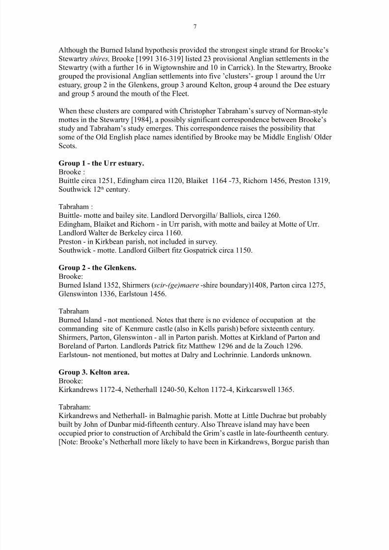
Although the Burned Island hypothesis provided the strongest single strand for Brooke’s
Stewartry shires, Brooke [1991 316-319] listed 23 provisional Anglian settlements in the
Stewartry (with a further 16 in Wigtownshire and 10 in Carrick). In the Stewartry, Brookegrouped the provisional Anglian settlements into five ’clusters’- group 1 around the Urr
estuary, group 2 in the Glenkens, group 3 around Kelton, group 4 around the Dee estuary
and group 5 around the mouth of the Fleet.
When these clusters are compared with Christopher Tabraham’s survey of Norman-style
mottes in the Stewartry [1984], a possibly significant correspondence between Brooke’sstudy and Tabraham’s study emerges. This correspondence raises the possibility that
some of the Old English place names identified by Brooke may be Middle English/ Older
Scots.
Group 1 - the Urr estuary.
Brooke :
Buittle circa 1251, Edingham circa 1120, Blaiket 1164 -73, Richorn 1456, Preston 1319,
Southwick 12th
century.
Tabraham :Buittle- motte and bailey site. Landlord Dervorgilla/ Balliols, circa 1260.
Edingham, Blaiket and Richorn - in Urr parish, with motte and bailey at Motte of Urr.
Landlord Walter de Berkeley circa 1160.
Preston - in Kirkbean parish, not included in survey.Southwick - motte. Landlord Gilbert fitz Gospatrick circa 1150.
Group 2 - the Glenkens.
Brooke:
Burned Island 1352, Shirmers ( scir-(ge)maere -shire boundary)1408, Parton circa 1275,
Glenswinton 1336, Earlstoun 1456.
Tabraham
Burned Island - not mentioned. Notes that there is no evidence of occupation at thecommanding site of Kenmure castle (also in Kells parish) before sixteenth century.
Shirmers, Parton, Glenswinton - all in Parton parish. Mottes at Kirkland of Parton and
Boreland of Parton. Landlords Patrick fitz Matthew 1296 and de la Zouch 1296.
Earlstoun- not mentioned, but mottes at Dalry and Lochrinnie. Landords unknown.
Group 3. Kelton area.
Brooke:Kirkandrews 1172-4, Netherhall 1240-50, Kelton 1172-4, Kirkcarswell 1365.
Tabraham:Kirkandrews and Netherhall- in Balmaghie parish. Motte at Little Duchrae but probably
built by John of Dunbar mid-fifteenth century. Also Threave island may have been
occupied prior to construction of Archibald the Grim’s castle in late-fourtheenth century.
[Note: Brooke’s Netherhall more likely to have been in Kirkandrews, Borgue parish than

8/6/2019 The Gaelic Clans of Galloway
http://slidepdf.com/reader/full/the-gaelic-clans-of-galloway 8/16
8
in Balmaghie.]
Kelton - pre- seventeenth century three parishes, Kelton, Gelston and Kirkcormack. No
mottes in earlier Kelton, but motte at Gelston (Ingleston), landlord John of Gelston 1282and at Kirkcormack, landlord lords of Galloway circa 1170.
Kircarswell - in Rerrick parish, with motte and bailey. Landlord and date unknown, but
probably held separately from lands of Dundrennan Abbey so may have already existedin 1142.
Group 4. Dee estuary.
Brooke :
Kirkcudbright 1165-71, Tywnholm 1154-65, Miefield 1456, Senwick circa 1275.
Tabraham:Kirkcudbright - mottes at Bombie Castle, Castle Fergus and Culdoach. Bombie Castle
may be a ringwork belonging to John of ‘Bundeby’ 1296, Castle Fergus (Lochfergus)
originally two islands, but after loch drained site badly damaged by agriculture. Landlord
Lords of Galloway circa 1150.Twynholm and Miefield - motte at Twynholm. Landlord Walter de Twynham 1282. Also
an Ingleston farm 1 km from motte. Miefield is 2.5 km north of Trostrie motte whichTabraham compares with Boreland of Parton as possibly pre-Norman. Alternatively, the
Meythfelde [ Exchequer Rolls 1456] identified by Brooke as Miefield in Twynholm parish
may be Mayfield in Kelton parish which is 500m from Kirkcormack motte.
Senwick - no motte, but landlord Lady Elena de la Zouch 1286.
Group 5 -mouth of Fleet.
Brooke:Ardwall Island, Kirkandrews circa 1275, Plunton 1458, Girthon 1296, River Fleet 1300,
Skyreburn ( scir-burna shire (boundary) stream)1494.
Tabraham:
Ardwall Island - not mentioned. Irish style sixth century chapel site on island. Anglian
link is Old English personal name Cuthgar found on memorial slab at chapel site.Kirkandrews - motte at Roberton. Landlord Bernard de Ripley circa 1230. There is an
Ingleston 500m from Roberton motte. Also motte at Barmagachan and motte and bailey
at Boreland of Borgue. Landlords de Moreville circa 1162 x 1170 and de Campania circa
1170. [Note -if the Netherhall of Brooke’s Group 3 is Netherhall in Balmaghie, thenBernard de Ripley was landlord of Kirakndrews (St. Andrew’s) Balmaghie not
Kirkandrews Borgue.]
Plunton - Lennox Plunton, Plunton Mains and Mill of Plunton lie between theKirkandrews, Barmagachan and Borgue mottes and Girthon (Cally) motte.
Girthon -motte at Cally. Lady Elena de la Zouche owned third part of vill of Girtun 1296.
River Fleet - lies between Cally motte in Girthon and Boreland of Anwoth motte and bailey, landlord David fitz Teri circa 1170. Additional motte and bailey in Anwoth at
Kirkclaugh.
Skyreburn - not mentioned by Tabraham.

8/6/2019 The Gaelic Clans of Galloway
http://slidepdf.com/reader/full/the-gaelic-clans-of-galloway 9/16
9
Tabraham listed his Norman settlements by parish. Listed by parish, Brooke found
Anglian settlements in Anwoth, Balmaghie, Borgue (includes Kirkandrews and Senwick),
Buittle, Colvend and Southwick, Girthon, Kells, Kelton (includes Gelston andKirkcormack), Kirkbean, Kirkcudbright (includes Dunrod and Galtway), Parton, Rerrick,
Twynholm (includes Kirkchrist) and Urr. Excluding Kirkbean which was not surveyed by
Tabraham; out of the remaining 13 parishes Tabraham found Norman mottes in 11 of them.
The two exceptions are Balmaghie and Kells. For Balmaghie, Brooke’s argument is thatthe ‘ Nederhall in cella de Kirkandres’ [St Bees Register 78] is Netherhall in Balmaghie
(St. Andrew’s) parish. However, Oram [2000 229] suggests that the Bernard of Ripley
who made the donation the St Bees text refers to probably gained Kirkandrews in Borgue
through marriage to a daughter of either Robert or William de Campania. If so then thenow lost Nederhall would have been part of the de Campanias’ lands of Castleton in
Borgue mentioned in a Lindores Abbey charter of 1260 [ Lindores Chartulary, no. CXIII].
Netherhall in Balmaghie is 1 km down stream from Threave castle and is likely to have
been a sub-division of Threave Mains (Threave Grange in 1456) and so a product of settlement by Scots speakers in the fourteenth century rather than Old English speakers in
the eighth century. Since Brooke’s evidence of Northumbrian settlement in Kells parishwas her mis-identification of Burned Island as the location variously called Irisbutil,
Erysbutil, Arsbutil, Erthbutil and Arthbutil in the Exchequer Rolls, Kells can be excluded.
Northumbrians or Normans?
From the perspective of a local historian familiar with the Stewartry of Kirkcudbright,
Daphne Brooke’s Northumbrian shires originally appeared convincing. The areas sheidentified as having been settled by Northumbrians are today occupied by the vivid green
fields of intensively managed dairy farms. These extend from the Fleet in the west across
the lower Dee valley, north towards Loch Ken and east to across the Urr valley. In thisfertile lowland zone the Anglians practised arable farming in their shires..Today, beyond
boundaries of these prosperous shires lie the rough grazing and forestry of the Stewartry
uplands and the mountainous area around lochs Trool, Dee and Doon. Here, as Brookedescribed [1991 316] the Britons (also described as the Cymry) mined for lead and gold
which they may have offered as tribute to the Anglians. The Britons also practised
pastoral agriculture, tending herds of cattle and flocks of sheep which ranged across the
uplands.
The difficulty with Brooke’s Northumbrians is that the Old English they spoke evolved
into a northern form of Middle English which can also be called Older Scots. In the northof England and the south-east of Scotland, this language evolution was continuous. In
south west Scotland, particularly in Galloway, the process was interrupted by the advent
of Gaelic which became the main language of Galloway from the tenth to the fifteenthcentury. If Brooke’s Northumbrians had settled in the Stewartry as thoroughly as she
believed, then their Old English place names may have survived the language shift to
Gaelic.

8/6/2019 The Gaelic Clans of Galloway
http://slidepdf.com/reader/full/the-gaelic-clans-of-galloway 10/16
10
However, when the extent of the Norman settlements identified by Chris Tabraham is
taken into account, a different possibility emerges. Like Brooke’s Northumbrian
settlements, Tabraham’s Norman settlements are distributed across the lowland parishesof the Stewartry, in areas of better quality/ arable land. Although charter evidence
equivalent to David I’s grant of lands in Annandale to the Bruces is lacking, records of
gifts and donations to the Church allowed Tabraham to connect surviving Normanmottes with 14 Anglo- Norman (mainly Cumbrian) landholders between 1150 and 1296.
These are the same sources which Brooke relied on to provide the earliest forms of the
place names used in her study. Given this overlap between Northumbrian and Normansettlements, it is therefore possible that some of the place names Brooke took to be Old
English may have been the product of Middle English / Older Scots speakers in the
twelfth and thirteenth centuries.
If this interpretation of the evidence shifts the focus from Brooke’s Northumbrians to
Tabraham’s Normans, what are the implications? An immediate consequence is that
rather than the broad sweep of Brooke’s narrative which divides the Stewartry into an
upland/ pastoral/ British zone and a lowland / arable/ Anglian zone, Tabraham’s evidence points to a scatter of 14 small blocks of Anglo-Norman settlement centred on their
mottes. These Norman enclaves would have been surrounded by Gaelic speakers. Thisleads on to an interesting question.
If, as Richard Oram [1993] has suggested, Fergus of Galloway and his descendants
depended for their power and position on Galloway’s Gaelic ‘aristocracy and people’,why did Uhtred, Roland (Lachlann) and Alan introduce Anglo-Norman settlers? One
possibility is that they did so to add Norman knights to their military strength. However,
when King John of England wanted Alan of Galloway’s help for a campaign in Wales in1212, he asked Alan to send 1000 of his best and most active Galwegians to Chester
rather than 14 of his English knights [Oram 2000 118, CDS Vol. I no. 529].
An alternative hypothesis is that the Norman settlements were planned as part of a policy
of agricultural improvement. What the lords of Galloway wanted were better, iron-tipped,
ploughs. Access to this ‘new’ technology would boost cereal production which in turnwould increase the wealth of their lands and support a larger population, so providing
more fighting men. Although this is speculative, there is some supporting evidence which
connects lands held by Anglo-Normans with arable farming and oxen for ploughing.
Before the use of iron in ploughs, plough pebbles were used. Plough pebbles were found
at Whithorn [Hill, P.H.- and Kucharski, K, ‘Early Mediaeval Ploughing at Whithorn and
Chronology of Plough Pebbles’, Transactions DG NHAS Series III, Vol 65, 73] and their use dated to between late fifth and early ninth centuries. After mentioning the use of
plough pebbles, Archibald Duncan [Scotland The Making of a Kingdom Edinburgh 1978
310] draws attention to a
remarkable document of 1162 X 1189 [which] provides that the brethren of the
hospital of Lauder might send their ploughs to the lord’s smith who ‘shall make
all the irons of their ploughs and those things of iron which pertain to their

8/6/2019 The Gaelic Clans of Galloway
http://slidepdf.com/reader/full/the-gaelic-clans-of-galloway 11/16
11
ploughs’
The ‘remarkable document’ is a charter of donation and the lord referred to was Richardde Morville [ Liber St. Marie de Dryburgh 267-269] whose daughter Elena (or Helen)
married Roland (Lachlann) of Galloway.
The de Morville connection provided Roland with a new circle of dependants on
whom he could draw. Through it he strengthen his existing kinship bond with the
family of Cospatric of Workington, whose elder son, Thomas, was a tenant of William de Lancaster, lord of Kendal, brother-in-law of Richard de Morville.
Thomas’ younger brother, Gilbert, was to become one of Roland’s intimates.
Through the de Morvilles, Roland also forged ties with the de Vieuxpoint family,
who were to become his tenants for Sorbie in the Machars after 1185.[Wherethere was a probably related Ingleston farm] A final link with the de Morvilles is
represented by Roger Masculus, member of a family who were tenants in the
lordship of Lauderdale, who received a moiety of the lands of Colvend from
Roland. [Oram 2000 99]
The Hugh de Morville for whom the Boreland of Borgue motte and bailey wereconstructed is likely to have been Richard de Morville’s elder brother rather than his
father Hugh de Morville, Constable of Scotland. [Oram 2000 195].
The following are taken from the Paradox of Medieval Scotland database and showconnections between the lands of Anglo-Normans and arable farming (ploughgates),
including some mentions of oxen and mills. However they provide no direct evidence for
the use of iron in the ploughs used in Galloway.
Borgue - Bernard of Ripley and his wife Margaret gifted St Bees Priory half a mark from
their mill of Kirkandres (Borgue). Existence of mill implies arable land.http://www.poms.ac.uk/db/record/source/5471/#
Colvend - Roger Maule has given and granted and established by this his charter to StBees Priory … pasture for four oxen and four cows and one horse.
http://www.poms.ac.uk/db/record/source/5685/#
Colvend - Thomas, son of Cospatric, with the counsel and consent of Patrick his son, hasgiven, granted and by this present charter established, to St Bees Priory…pasture for four
draught animals and one horse.
http://www.poms.ac.uk/db/record/source/4820/#
Kirkbean - Alan son of Roland, constable of Scotland, has given, granted, and established
by his charter to Adam son of Gilbert the dispenser, for his homage and service, Airdrie(KCB), by the boundaries by which Gilbert his father held it from Alan’s father Roland,
in feu and heritage, for the service of the tenth part of one knight. Airdrie is to be free
from multure, and Adam can grind his grain at Alan’s mill at Preston (Prestonmill, KCB)
immediately after the grain already in the hopper, unless that be Alan’s own grain or that

8/6/2019 The Gaelic Clans of Galloway
http://slidepdf.com/reader/full/the-gaelic-clans-of-galloway 12/16
12
of the church
http://www.poms.ac.uk/db/record/source/2651/#
Kirkgunzeon - Roland son of Uhtred included ‘pasture for four oxen’ in his confirmation
of the lands Uhtred had granted to Holm Cultram Abbey
http://www.poms.ac.uk/db/record/source/2713/#
Troqueer -Uhtred son of Fergus, to his lord and father, Christian, bishop of Galloway
(i.e., Whithorn), noting that he and his heir (unnamed) have granted and given to StLeonard and to St Peter’s Hospital, York, one ploughgate of land and a toft in Troqueer.
http://www.poms.ac.uk/db/record/source/2753/#
[Tabraham did not include Troqueer in his study, but there is a twelfth century motte near
the Nith in Troqueer parish.http://canmore.rcahms.gov.uk/en/site/65677/details/mote+of+troqueer/ ]
Twynholm - William son of Gamelin of Twynholm ‘with the consent of his lord Alan son
of Roland’ granted Holyrood abbey ‘four acres of land in the territory of the same villa, by the bounds by which he perambulated it, one house in the same villa, in which he has
saised the said canons. He gives and grants common pasture for up to 16 draught animalsand one horse, and with all other common easements of the same villa.’
http://www.poms.ac.uk/db/record/source/5335/#
Urr - Uhtred’s donation of churches of Colmanale and St. Brigid of Blaiket to Holyroodabbey (confirmed by his grandson Alan) included a ploughgate of land with each.
http://www.poms.ac.uk/db/record/source/2632/#
In the original Latin text of the charter of Airdrie in Kirkbean, the farm is called Ardarie
[Stringer 1998 103], containing the Gaelic place name element airigh. The present farm
of Airdrie lies at 100m and there is an Airdrie Hill at 357m above the farm with the land beyond rising up towards Criffel at 569 m. Prestonmill lies 50 m below Airdrie.
Presumably, the lower lying parts of Ardarie had originally provided winter grazing for
livestock pastured on the higher ground during the summer. The lower lying land wasthen converted to arable by Gilbert the dispenser after he received Ardarie from Roland.
In this instance then, there seems to be evidence for a change in land use brought about
when a Gaelic tenant was replaced by an Anglo- Norman.. Was this pattern repeatedacross the Stewartry? If it was, would there not have been a danger of alienating the
Gaelic kindreds? This is a possibility, however it seems likely that the lands between the
Urr and the Nith (including Kirkbean) were not part of Fergus’ original territory, but had been acquired by Uhtred in 1164 having previously belonged to Radulf of Nithsdale.
Called Desnes Ioan, the territory was ‘parcelled out with great rapidity in a programme
of intensive settlement‘ by Uhtred [Oram 2000 88-9]. In contrast, the settlement of ‘aristocratic colonists’ (as Oram describes them) in the western Stewartry and
Wigtownshire was more limited. This could mean that Uhtred, Roland and Alan needed
to avoid conflict with the Gaelic kindreds in these areas, but were not so constrained in
Desnes Ioan.

8/6/2019 The Gaelic Clans of Galloway
http://slidepdf.com/reader/full/the-gaelic-clans-of-galloway 13/16
13
In Wigtownshire the only known Anglo-Norman settlers were the de Vieuxponts in
Sorbie. Their settlement followed Roland’s acquisition of his uncle Gille Brigte’s landsafter Gille Brigte’s death in 1185. The main Anglo-Norman settlements outside Desnes
Ioan were therefore in the western Stewartry. Did these settlements displace any Gaelic
landholders? This is a difficult question to answer. Apart from Borgue, where there arethree mottes and Anwoth, where there are two (if Polcree is excluded as a later
construction), the mottes are scattered rather than concentrated. If the mottes can be
associated with the use of a new type of plough rather than an attempt at colonisation,they may have been fitted into an existing pattern of land use in areas which were under-
utilised. If the new ploughs were used to create broad rigs, then this would have extended
the area of cultivatable land. In areas like Borgue, where the soil is thin and dries out
quickly, the broad rigs would have helped conserve moisture. In other areas, where therewas the opposite problem of water-logging, the raised rigs could help keep the soil drier.
This is, however, a rather speculative hypothesis.
Gaelic settlement patterns
If Anglian/ Northumbrians settlement in the Stewartry was less extensive than suggested
by Brooke, any settlements which did exist would have been absorbed into Gaelic
settlements in the tenth century. If Northumbrian settlement was less extensive, then it is
unlikely that Brooke’s Northumbrian shires existed and so could not have provided thecore lowland territories of Fergus’ kingdom in the twelfth century. A further consequence
is that neither the pattern of Norman mottes and associated landholdings nor the pattern
of Douglas landholdings as recorded in 1456 can be assumed to reflect settlement patterns as they existed at the beginning of the twelfth prior to Fergus’ rise to power.
A clearer picture of Gaelic settlement in the lowlands of the Stewartry is thereforerequired if the origin and development of the lordship of Galloway is to be understood.
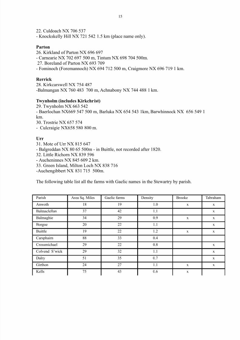
The following list shows the nearest (surviving) Gaelic named farms to Tabraham’s
Norman mottes in the Stewartry parishes where Brooke proposed Anglian settlements.The farm names used are those identified as Gaelic by Herbert Maxwell in The Place
Names of Galloway. The numbering of the mottes is from Tabraham.
Anwoth.
1. Boreland of Anwoth NX 584 550
- Jennoch (Gennoch) NX 578 560 1 km, Drummuckloch NX 570 545 1.5 km,
Lagganmullan NX 565 554 2 km, Killiegowan NX 585 570 2 km.[+ Ardwall if Gaelic]2. Kirkclaugh NX 534 521
- Low Auchenlarie NX 536 524 300 m, High Auchenlarie NX 536 533 1 km, Laggan NX
546 531 1.5 km., Bardriston NX 530 528 700 m.3. Pulcree NX 593 583 . Probably later medieval, not Norman. Pulcree part of Douglas
lordship of Galloway 1455.
- Pulcree NX 588 581 500m, Killern NX 582 583 1.5 km.

8/6/2019 The Gaelic Clans of Galloway
http://slidepdf.com/reader/full/the-gaelic-clans-of-galloway 14/16
14
Balmaghie- no Norman mottes or recorded Anglo-Norman landholdings.
Borgue (includes Kirkandrews and Senwick)7. Boreland of Borgue NX 646 517.
- Glentruil NX 647 512 500 m, Auchenhay NX 636 516 1 km.
8. Roberton NX 603 485-Barlocco NX 783 472 1.5 km.
9.Barmagachan NX 613 394
- Barmagachan farm adjacent, Kildarroch NX 611 504 (in ruins, 1850) 1 km.
Buittle.
10 Buittle castle NX 819 616
-Auchengate NX 819 621 500m, Craignair NX 818 609 500 m.
Colvend and Southwick
11. Southwick NX 936 570
- Kells (?) NX 941 572 500 m.12. Boreland of Colvend NX 869 541
- Glenstoking NX 863 527 500 m, Barcloy NX 856 531 1 km. Note: parish has highest number, six, of Auchen- farms in the Stewartry. Auchenhay,
Auchenhill, Auchenjury, Auchenlosh, Auchensheen and Auchenskeoch.
Girthon
16. Cally NX 606 556
- Drumwall NX 615 559 1 km. ? Maxwell gives as druim ghall .
Kells- no Norman mottes or recorded Anglo-Norman landholdings.
Kelton (includes Gelston and Kirkcormack)
18. Ingleston NX 774 579
- Airieland NX 757 572 1.5 km, Craigley NX 762 581 (formerly part of Ingleston lands)
Glenyerrock NX 798 567 2 km.19. Kirkcormack NX 716 574
- Barfraggan NX 733 564 2 km.
20. Netherthird NX 710 554 (possibly later medieval)
- Knockskelly Hill NX 721 542 1.5 km. (place name only).
Kirkbean- no Norman mottes.
- Airdie NX 966 587 recorded as Ardarie in charter circa 1200.http://www.poms.ac.uk/db/record/source/2651/#
Kirkcudbright (includes Dunrod and Galtway)
21. Bombie Castle NX 715 505 [ring-fort]
- Balgreddan NX 726 517 1.5 km.
22. Castle Fergus NX 698 507
-Canee NX 687 500 1.5 km, Auchenflower NX 688 490 2km.
8/6/2019 The Gaelic Clans of Galloway
http://slidepdf.com/reader/full/the-gaelic-clans-of-galloway 15/16
15
22. Culdoach NX 706 537
- Knockskelly Hill NX 721 542 1.5 km (place name only).
Parton
26. Kirkland of Parton NX 696 697
- Carnearie NX 702 697 500 m, Tintum NX 698 704 500m.27. Boreland of Parton NX 693 709
- Fominoch (Foremannoch) NX 694 712 500 m, Craigmore NX 696 719 1 km.
Rerrick
28. Kirkcarswell NX 754 487
-Balmangan NX 760 483 700 m, Achnabony NX 744 488 1 km.
Twynholm (includes Kirkchrist)
29. Twynholm NX 663 542
- Baerlochan NX669 547 500 m, Barluka NX 654 543 1km, Barwhinnock NX 656 549 1
km.30. Trostrie NX 657 574
- Culcraigie NX658 580 800 m.
Urr
31. Mote of Urr NX 815 647
- Balgreddan NX 80 65 500m - in Buittle, not recorded after 1820.32. Little Richorn NX 839 596
- Aucheninnes NX 845 609 2 km.
33. Green Island, Milton Loch NX 838 716-Auchengibbert NX 831 715 500m.
The following table list all the farms with Gaelic names in the Stewartry by parish.
Parish Area Sq. Miles Gaelic farms Density Brooke Tabraham
Anwoth 18 19 1.0 x x
Balmaclellan 37 42 1.1 x
Balmaghie 34 29 0.9 x x
Borgue 20 22 1.1 x
Buittle 19 22 1.2 x x
Carsphairn 88 33 0.4
Crossmichael 29 22 0.8 x
Colvend S’wick 29 32 1.1 x
Dalry 51 35 0.7 x
Girthon 24 27 1.1 x x
Kells 75 43 0.6 x

8/6/2019 The Gaelic Clans of Galloway
http://slidepdf.com/reader/full/the-gaelic-clans-of-galloway 16/16
16
Kelton 18 10 0.6 x x
Kirkbean 15 5 0.3
Kirkcudbright 18 12 0.6 x x
Kirkgunzeon 18 17 0.9
Kirkmabreck 34 25 0.7Kirkpat. Durham 30 26 0.9
Kirkpat. Irongray 23 17 0.7
Lochrutton 13 10 0.8 x
Minnigaff 137 83 0.6
New Abbey 20 17 0.9
Parton 28 23 0.8 x x
Rerrick 33 28 0.8 x x
Terregles 7 4 0.6
Tongland 13 11 0.9Troqueer 21 13 0.6
Twynholm 17 10 0.6 x x
Urr 24 14 0.6 x x
Totals 852 651 0.8