the forks of rancocas creek: a history
TRANSCRIPT

© 2013 Paul W. Schopp • Post Office Box 648, Palmyra, New Jersey i
The Forks of
Rancocas Creek:
A History
Rancocas State Park
Township of Hainesport, New Jersey
Prepared For:
Burlington County Board of Chosen Freeholders,
Burlington County Division of Parks
6 Park Avenue
Eastampton, New Jersey 08060
Prepared By:
Paul W. Schopp, Historian
Post Office Box 648
Palmyra, New Jersey 08065-0648
May 2013
© 2013 Paul W. Schopp • Post Office Box 648, Palmyra, New Jersey i
Table of Contents Introduction .................................................................................................................................................. ii
Historical Significance of The Forks ............................................................................................................ iii
The Forks of Rancocas Creek: A History ...................................................................................................... 1
Contact Period ................................................................................................................................. 1
Initial English Settlement Period ...................................................................................................... 7
Colonial Period and Charles Read’s Tenure ..................................................................................... 8
Subsequent Ownership in The Forks ............................................................................................. 10
Riverdale ........................................................................................................................................ 13
Sand-Mining Operations ................................................................................................................ 15
FIGURES (Maps):
Figure 1: Herrman, 1673 ............................................................................................................................... 1
Figure 2: Herrman, 1673 ............................................................................................................................... 2
Figure 3: Vermeule, c.1878 ........................................................................................................................... 3
Figure 4: Seller, 1678 .................................................................................................................................... 4
Figure 5: Visscher, c.1651 ............................................................................................................................. 5
Figure 6: Vinckeboons, c.1639 ...................................................................................................................... 6
Figure 7: Woodward, 1941 ........................................................................................................................... 9
Figure 8: Otley and Whiteford, 1849 .......................................................................................................... 11
Figure 9: Parry, Sykes and Earl, 1859 .......................................................................................................... 12
Figure 10: Scott, 1876 ................................................................................................................................. 13
Figure 11: Stokes 1887 ................................................................................................................................ 14
Figure 12: Stokes 1887 ................................................................................................................................ 14
Figure 13: Stokes, 1887 ............................................................................................................................... 15
Figure 14: New Jersey Geological Survey, 1931 .......................................................................................... 17
Figure 15: Anderson, 1932 .......................................................................................................................... 19
Figure 16: Township of Hainesport, Revised to 1988 ................................................................................. 20

© 2013 Paul W. Schopp • Post Office Box 648, Palmyra, New Jersey ii
Introduction
In January 2013, Burlington County Historian Joseph Laufer received a request from the
Burlington County Division of Parks for information on the history of the portion of the
Rancocas State Park located in Hainsport Township in the area traditionally known as the “Forks
of the Rancocas” (or simply the “Forks”) which is formed by the confluence of the North and
South Branches of the Rancocas Creek. Mr. Laufer enlisted the assistance of Paul W. Schopp to
research the topic for the county. This report is the result of Mr. Schopp’s inquiry into the history
of the Forks.
This is not an overall history of the Rancocas and its two branches, nor does it provide
information on sail and steam navigation and landings along the creek. The documentation that
follows focuses on the peninsula between the North and South Branch and its land use over time
from the period of first contact between Native Americans and European traders in the 1600s
forward. Mr. Schopp relied on contemporaneous historic maps, other primary documents, and
some secondary source material. He conducted only a limited title search of the various tracts of
land comprising the peninsula. The report specifically discusses the native village of King
Remkokes and then the Breezy Ridge farm of Charles Read, constructed during the colonial
period. Scant mention is made of other owners or parcels of land as most of these other parcels
served as banked meadows or livestock corrals with virtually no buildings present. The report
ends with discussing sand-mining operations that erased the evidence of previous cultures and
their occupation of the Forks. Mr. Schopp provides this report as a service to the Burlington
County Board of Chosen Freeholders and the Division of Parks, which should use the historical
narrative contained herein for preparing interpretative materials and to educate the county’s Park
Rangers.

© 2013 Paul W. Schopp • Post Office Box 648, Palmyra, New Jersey iii
Historical Significance of The Forks
The location of the Forks provided numerous advantages that have served diverse peoples over
many centuries. Located at the point where the two main branches of the Rancocas meet and
well within the navigable tidal waters of the Delaware River system, the Forks enjoyed easy
access both downriver to the Delaware River as well as up river into the interior of what
constitutes most of northern Burlington County. Navigation flourished on the Rancocas since the
Lenape and their predecessors first occupied the shores of the creek. The land at the Forks
historically was a high plateau of inner coastal plain soils, which offered those residing there dry
ground with commanding views of the waterways.
Three periods or phases in the history of The Forks stand out and illustrate the broad course of
American history in this part of the county. First it served as an important Native American
settlement site offering strategic and advantages within the region. While documentation of this
period is limited and the site itself was later disturbed during mining operations, evidence from
maps and early accounts indicates there was, at times, a major Indian settlement at this location
in the 1600s and probably long before. The earliest Europeans named the creek for Remkokes,
the native king who occupied the surrounding lands. Whether this was the traditional name given
to the stream by the indigenous people is unknown. Some scholars view seventeenth-century
cartography as more art than science, yet the evidence on maps that are included as figures in this
report appear to have a high degree of accuracy in correctly placing the location of native
villages and settlements. While a c.1639 map of the area depicts Remkoke’s village in the area of
Lumberton or Vincentown, the village had relocated to the Forks of the Rancocas by the 1650s
according to maps of that period. This Lenape village remained a viable community at the Forks
into the 1680s. The West New Jersey Proprietors acquired land that included the Forks of the
Rancocas from the Lenape in the fall of 1677 (Nelson 1899:395). European occupation of the
Forks, however, began in the early 1690s with Daniel Wills Jr.
The second significant period in the history of the Forks illustrates the development of European-
American agricultural practices. During the 1750s, 492 acres, comprising the majority of today’s
park land in the Forks, came into the possession of Charles Read, one of the most notable
citizens of West New Jersey in his time. Born in 1715 to a Philadelphia merchant, Charles spent
his formative years traveling abroad before settling in Burlington in 1739. He was admitted to
the bar and served in many capacities in the judicial and legislative branches of colonial
government. Instrumental in establishing the Brotherton Indian Reservation, Read also
constructed four of Burlington County’s most famous prerevolutionary ironworks: Ætna,
Taunton, Atsion, and Batsto. He was a man of means and influence throughout Burlington
County and many other locations in America during his lifetime in the Colonial Period. Voted
into membership of the American Philosophical Society in Philadelphia during 1768, Read
corresponded regularly with Benjamin Franklin on a wide variety of subject matters. Most
relevant to his land holdings in the Forks, Read conducted and recorded many agricultural
experiments at his farms there and in Springfield. He also constructed a residence which stood on

© 2013 Paul W. Schopp • Post Office Box 648, Palmyra, New Jersey iv
high ground above the South Branch. This dwelling remained in situ until flames destroyed the
structure during the 1920s (Woodward 1941).
The third important period in the Forks history comes in the first decade of the twentieth century
and reflects the advances of industrial development in the nation at the time. Philadelphia’s
unprecedented campaign of erecting buildings and improving infrastructure dramatically
increased the demand for construction sand. The land within the Forks contained deposits of
sand ideal for construction, making it a valuable mineral resource. Mining operations began in
1905 and continued for six to eight years, eventually resulting in the removal of sand deposits
over much of the area, thereby eradicating the earlier native and colonial settlement sites. The
peninsula became a veritable wasteland with areas gouged and scarred by excavating machines
and mounds containing turf and overburden.
In the years since excavation has ceased, the area has witnessed a remarkable recovery through
the process of natural forest succession, returning most of the area to woodland and marsh. This
makes the Forks a valuable location for studying and interpreting ecological processes. While the
loss of early native and colonial landscape, occupation sites, and architecture due to the sand-
mining operations is regrettable, the historical narrative that comes out of this transformation is a
powerful one that can be used to educate park visitors about the dynamic changes that have
occurred over the past four centuries.
© 2013 Paul W. Schopp • Post Office Box 648, Palmyra, New Jersey P a g e | 1
The Forks of Rancocas Creek: A History
Contact Period
During the early seventeenth century, Southern New Jersey hosted settlements by the Dutch and
a disparate group of people associated with New Sweden, but the indigenous natives comprised
the bulk of humanity living on the landscape. In 1664, Englishman Richard Nicolls sailed a small
flotilla of warships into New York Harbor and received the surrender of New Amsterdam from
the Dutch without firing a shot (Weslager 1961:237). The Dutch struck back at the English
interlopers in New Netherland during 1673 and temporarily won their colony back. However, the
recovery was short-lived and Holland forever surrendered any claim it had to New Netherland to
the English in the 1674 Treaty of Westminster. Dutch forces withdrew from the Hudson River
and the English resumed its rule and ownership (Weslager 1961:252). Four years prior to the
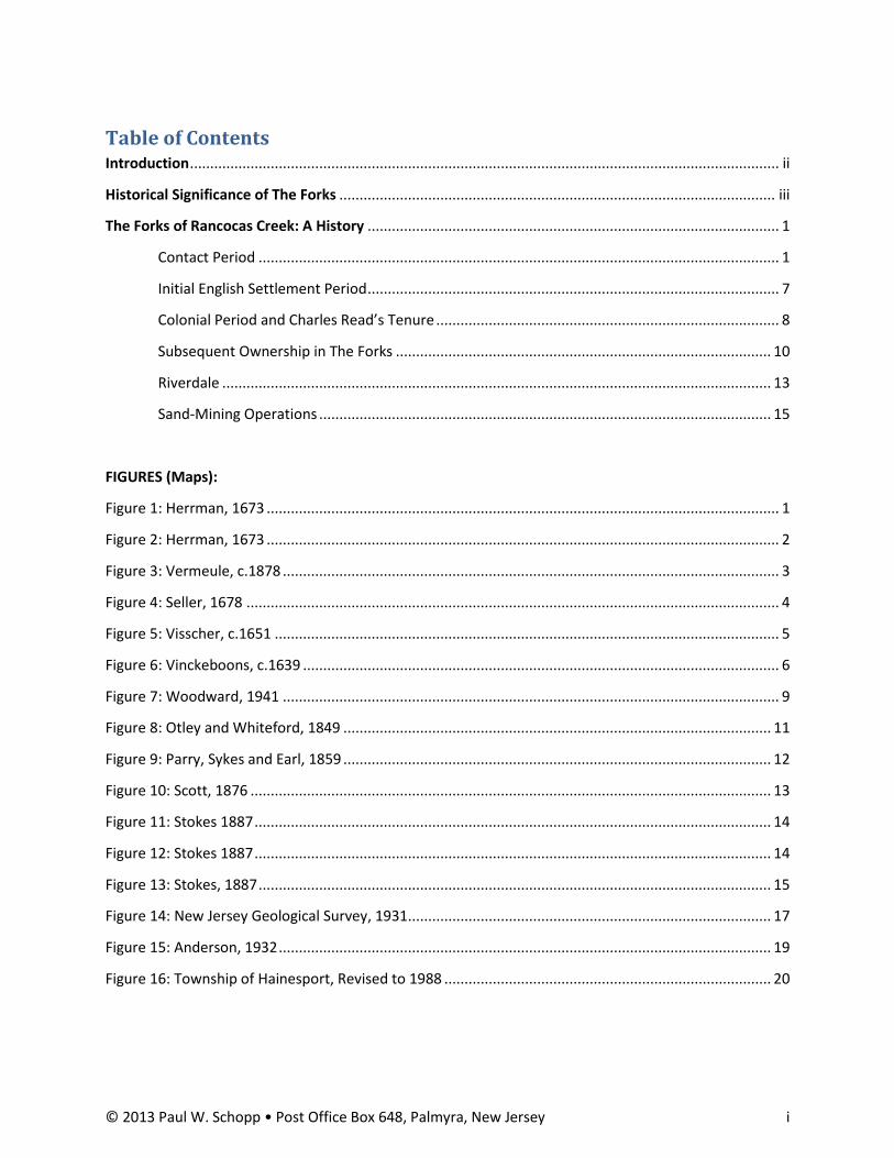
Treaty of Westminster, Augustine Herrman, a Maryland resident originally from Bohemia,
traveled the region and drafted a map as a result of his trip. Titled Virginia and Maryland as it is
Planted and Inhabited this Present Year 1670 and published in 1673, the map not only depicts
the two English colonies of Maryland and Virginia, but also much of West New Jersey:
Figure 1: Herrman, 1673

© 2013 Paul W. Schopp • Post Office Box 648, Palmyra, New Jersey P a g e | 2
The map delineates most of the streams and rivers in New Jersey from Monmouth County south.
In the Forks of the Rancocas, Herrman depicts a substantial Indian village, which he likely
viewed firsthand:
Figure 2: Herrman, 1673
The map also carries text concerning the inhabitants in this portion of New Jersey: “at present,
Inhabited Only or most By Indians,” confirming that the indigenous people comprised virtually
the entire population at that time, other than the small settlements of Swedes and Finns living
along or proximate to the Delaware River (Herrman 1673).
Alumhatta
© 2013 Paul W. Schopp • Post Office Box 648, Palmyra, New Jersey P a g e | 3
Following the Treaty of Westminster, William Penn involved himself in planning a Quaker
colony in West New Jersey. The London and Yorkshire Friends finally arrived here in 1677 and,
after reaching a compromise on redrawing the boundaries for the proprietary tenths, joined
together to create Burlington (Schopp 2010). As the Burlington London (Second) Tenth
inhabitants began to explore their new realm in the late 1670s, a number of them likely sailed
and/or canoed up the Rancocas Creek from its confluence with the Delaware River. On these
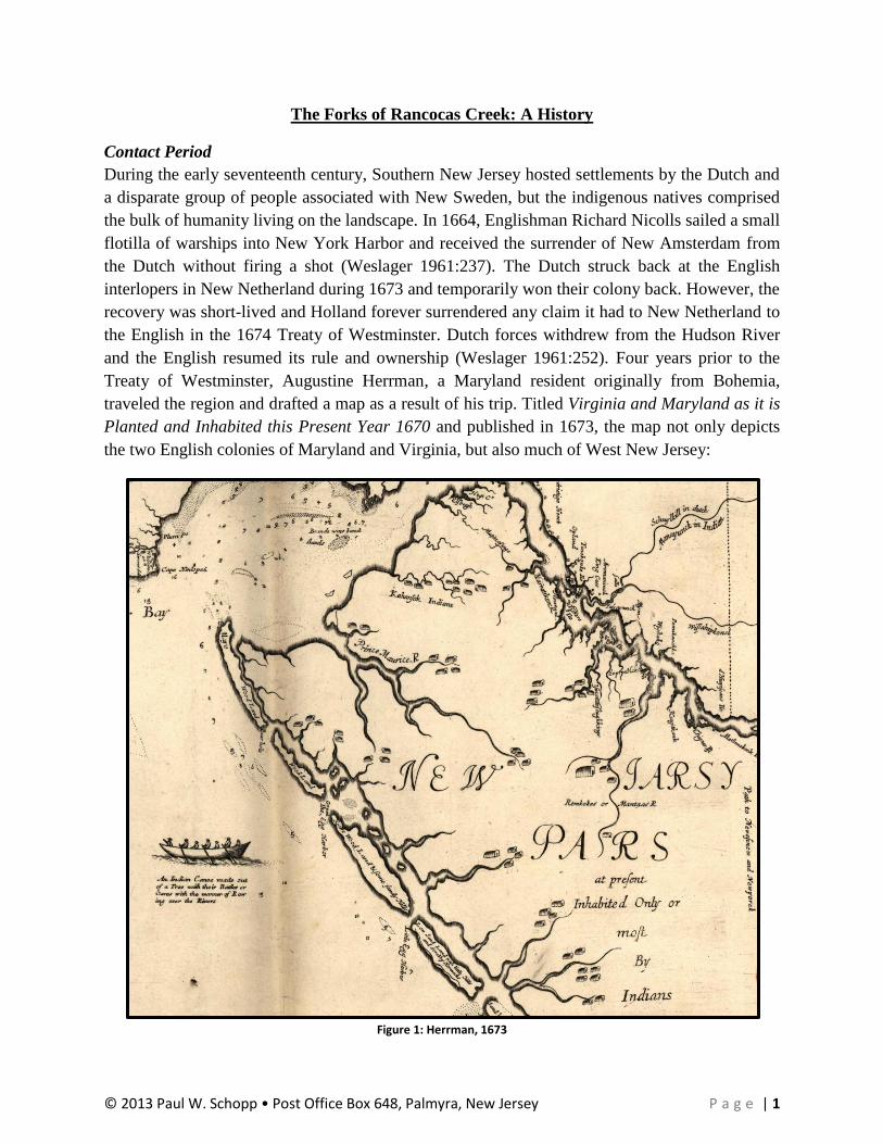
exploratory trips, the intrepid pioneers likely passed up the North Branch and then the South
Branch to observe locations for settlement. At the Forks between the two branches, a high sandy
plateau projected upwards some 30 feet above the wetlands and creek that surrounded this
peninsula, as depicted on this circa 1878 New Jersey Geological Survey topographical map:
Figure 3: Vermeule, c. 1878
Despite its seemingly strategic location, no proprietor initially laid claim to this land, perhaps in
deference to the Indian village there.1 John Seller’s Mapp of New Jersey, published in at least
two states or editions between 1675 and 1678, depicts the village. The 1675 edition does not
label the village with a name, but the 1678 edition labels this village as “Mispennunck,” as
shown below:
1 In his 1969 pamphlet, Hainesport: Biography of a Small Town, author Richard Pedlow states that the native village
carried the name “Sandhickney” (Pedlow 1969:6). An exhaustive check of seventeenth-century texts and maps, however, failed to identify a single use of this indigenous toponym, which is actually a derivative of a native name generally associated with the area of New Jersey from Trenton northward. So, Pedlow’s original source of this toponym has not yet been identified.

© 2013 Paul W. Schopp • Post Office Box 648, Palmyra, New Jersey P a g e | 4
Figure 4: Seller, 1678
Typical for map production during this period of time, cartographers and map publishers would
assemble as many maps as possible published by others showing the same area for which a new
map would be produced (Brown 1949:169-170). No doubt that Seller copied the same number of
Lenape longhouses from Herrman’s map, published in 1673. Likewise, it appears Seller also had
access to an unknown edition of Nicolæs Visscher’s map, Novi Belgii Novæque Angliæ Novæ et
Partis Virginæ [and other variant titles], published in different versions, with changes and
updates, between circa 1651 and 1685. The earliest version of this map, shown below, depicts
the village within the Forks as the second-largest native settlement on this portion of present-day
New Jersey. The largest village appears to be situated at the forks of Pennsauken Creek, it
containing one additional structure as shown on Visscher’s map below:

© 2013 Paul W. Schopp • Post Office Box 648, Palmyra, New Jersey P a g e | 5
Figure 5: Visscher, c.1651
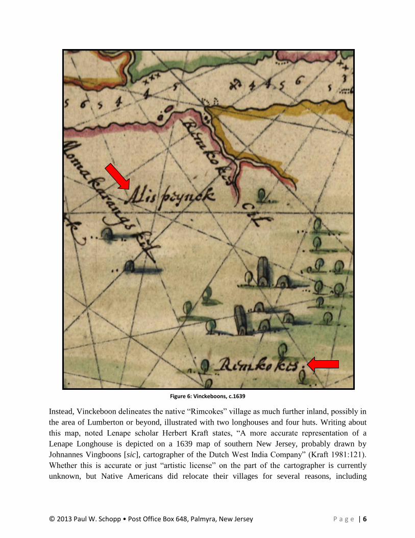
In turn, Dutch cartographer Visscher likely had full access to Hollander Joan Vinckeboon’s circa
1639 manuscript map, Cært vande Svydt Rivier in Niew Nederland. It appears, however, that
Visscher misinterpreted the label Vinckeboon applied to the area near the Forks. Vinckeboon
wrote the toponym “Alispeynck” between the Rancocas Creek and what appears to be the
Pennsauken Creek, but he fails to show a village located within the Forks of the Rancocas:
© 2013 Paul W. Schopp • Post Office Box 648, Palmyra, New Jersey P a g e | 6
Figure 6: Vinckeboons, c.1639
Instead, Vinckeboon delineates the native “Rimcokes” village as much further inland, possibly in
the area of Lumberton or beyond, illustrated with two longhouses and four huts. Writing about
this map, noted Lenape scholar Herbert Kraft states, “A more accurate representation of a
Lenape Longhouse is depicted on a 1639 map of southern New Jersey, probably drawn by
Johnannes Vingboons [sic], cartographer of the Dutch West India Company” (Kraft 1981:121).
Whether this is accurate or just “artistic license” on the part of the cartographer is currently
unknown, but Native Americans did relocate their villages for several reasons, including

© 2013 Paul W. Schopp • Post Office Box 648, Palmyra, New Jersey P a g e | 7
sanitation and defense. In 1634, English sea captain Thomas Yong, set sailed from Virginia in
and navigated up the coast. Arriving in what would become known as Delaware Bay, Yong
sought to interact with the indigenous people there. On July 27, he finally succeeded in bringing
a native onboard his ship, where he questioned the man through an interpreter. In part, Yong
states that the native reported the following:
He told me further that the people of that River were at warre with a certaine
Nation called the Minquaos [a.k.a. the Susquehannocks], who had killed many of
them, destroyed their corne, and burned their houses; insomuch as that the
Inhabitants had wholy left that side of the River, which was next to their enimies,
and had retired themselves on the other side farre up into the woods, the better to
secure themselves from their enimies. (Myers 1912:38, [original spelling retained
throughout])
The Susquehannocks sought to gain complete control of trade with the Dutch, and, after 1638,
with the Swedes, by shutting out the Lenape through warfare and intimidation. So the threat of
an imminent attack from the Susquehannocks might have driven King Ramcockes to move
farther inland from the Forks. By 1650, the Suquehannocks and the Lenape had made peace and
formed a mutual alliance of protection against the Iroquoian peoples comprising the Five Nations
Alliance (Van Zandt 2008:167). So the establishment or reestablishment of a village in the Forks
between 1639 and Nicholæs Visscher’s 1651 map or Augustine Herrman’s visit in 1670 is a
distinct possibility due to the cessation of hostilities between the Lenape and the
Susquehannocks. During the eighteenth and nineteenth centuries, local residents reported finding
many native artifacts on the land comprising the Forks, which reports are highly suggestive that a
contact period village occupied this bluff.
Initial English Settlement Period
English settlers soon arrived along the banks of the creek to establish plantations. The Rancocas,
known in the early days as Northampton River for the surrounding township, served as a
convenient thoroughfare of commerce for these tidewater farmers. Dr. Daniel Wills had
emigrated to the New World at Burlington on the good ship Kent in 1677 and remained a
resident there for approximately four years. In the fall of 1681, Dr. Wills requested the West
New Jersey Board of Proprietors to locate 500 acres of his proprietary share along the north
shore of Rancocas Creek before the Forks, situated on a tract of land between John Borton, John
Paine and a small creek. The Proprietors issued a warrant for the Surveyor General to locate the
land and return a written survey of the land, which he accomplished in 1681 (DeCou 1949:8-9,
237-239). Daniel Wills then relocated to this property from Burlington to establish his farm. The
Wills Plantation included the land that, today, comprises Henry Rowan’s former “Stone Bridge”
property, located off the east side of Bridge Street just north of the Centreton Bridge. Wills
resided on this farm until his death in 1698 (Newkirk 2001:97).
In May 1691, he gave to his son, Daniel Wills Jr., by deed of gift, 520 acres of unlocated land
from his proprietorship. In September of the same year, Daniel Jr. submitted a request to the

© 2013 Paul W. Schopp • Post Office Box 648, Palmyra, New Jersey P a g e | 8
Board of Proprietors, who issued a warrant to the Surveyor General for locating 480 acres of the
unsurveyed land. Deputy Surveyor Symon Charles surveyed the land at “…the Forks of
Ancokus.” Daniel Jr. became the first Englishman to hold title to the peninsula, or a portion of it,
between the North and South Branch of Rancocas Creek (Newkirk 2001:109).
Daniel Wills Jr. added to his land holdings in November 1697 when he purchased an additional
100 acres from Henry Mosley, the landowner to the east of Will’s Forks land. Daniel remained
tenured in the full 580 acres until February 1715, when he gave his son, James Wills, 200 of the
original 480 acres on the peninsula by deed of gift (Newkirk 2001:109). It is unclear whether
Daniel Jr. ever constructed a house at the Forks or whether he just employed the wetlands for
grazing cattle and sheep. At the age of 69, Daniel prepared his will, dated 25 January 1728. The
document lists him as a “husbandman of Northampton Township,” suggesting that he raised
livestock as part of his agricultural pursuits (Newkirk 2001:109-110). Daniel’s Will is somewhat
vague on the disposition of his land in the Forks and without a thorough title search, the history
of the land between 1728 and 1758, a span of thirty years, is unknown.
Colonial Period and Charles Read’s Tenure
Notable Burlington County resident Charles Read began acquiring land along the north side of
the South Branch in the area of the Forks as early as 1747, purchasing 40 acres there. He added
greatly to his holdings between 1754 and 1758, purchasing two large tracts in 1758 comprising:
…256 acres of loamy upland and black meadow from Andrew Conarro for £163;
and 234 adjacent acres from John Erwin for £400. Together these two places
comprised the plantation he called Breezy Ridge. From the limited evidence at
hand it appears that Breezy Ridge was a pretentious establishment. The
substantial hip-roofed house looking southward across the stream stood on an
eminence exposed to the breezes that swept up the Rancocas Valley. Nearby
stood a boathouse marked with the initials C.R. There is mention of “Read’s
Dam,” also, on the South Branch of the Rancocas which may have been nearby.
Five islands in the Rancocas, totaling 6½ acres in area, also were acquired in
1756—one by purchase, the others by survey under one of Read’s proprietary
grants.
Although the precise place of Read’s residence through these years is not
certain, there is evidence that for a time he lived at Breezy Ridge—he is referred
to in deeds given in 1760 as “Charles Read of Breezy Ridge.” Perhaps he
maintained his Burlington home and Breezy Ridge simultaneously, using the
latter as a summer retreat.
The entries in Read’s notes indicate unusual agricultural activity from 1756 to
1758. Presumably Breezy Ridge was the locale. Experiments as diverse as the
seeding of millet, the grafting of fruit and the feeding of cattle were recorded
during these years. That stumpy grafts were superior to slender ones he found to
be “strickly [sic] by Experim[en]t.”
On selling 20 cattle he had fattened on grass, he made a profit of £57. On
harvesting his hay crop in 1756, he noted the capacity of his barracks, and also
computed the weight of hay per cubical unit. When he butchered his hogs in 1757,

© 2013 Paul W. Schopp • Post Office Box 648, Palmyra, New Jersey P a g e | 9
he noted carefully the lost in weight of the dressed carcasses. No step in the day’s
work on the farm was too small to escape his attention.
Again at Breezy Ridge, Read experienced the common vexation of runaway
servants. In the Pennsylvania Journal for August 17, 1758, appeared an
advertisement offering 20s. reward for an Englishman named Joseph Dealy—who
ran away June 7 “from the plantation of Charles Read, Esq., at Breezy ridge in
Burlington County.” The advertisement was signed by Hugh Dunn, who may
have been Read’s tenant, or the superintendent of the plantation.
…Much of the soil on Breezy Ridge was light and sandy, not so suitable for
the growing of grain and grass crops as for sweet potatoes and other vegetables.
Coveting for the cultivation of crops the rich but undrained marshlands that
bordered the plantation, Read engaged on Thomas Rakestraw to ditch and bank
the meadows on the north side of this branch of the Rancocas. The terms of the
agreement reveal a creditable knowledge of agricultural engineering, which is
evidenced also by the description of the water engine in Read’s notes. The bank
was the kind “Commonly Called twelve by Four” (presumably 12 feet wide at the
base and 4 feet high), “the ditch to be Out side and a five-feet Drain behind the
Bank with the necessary Sluices, and always hereafter shall be repaired made and
amended and Skoured & Other necessary work Done for keeping the Same Dry.”
In 1761 Read sold Breezy Ridge to Thomas Bispham of the town of Gloucester.
(Woodward 1941:76-79)
The following map depicts Woodward’s interpretation of Breezy Ridge farm during Charles
Read’s tenure:
Figure 7: Woodward, 1941:77

© 2013 Paul W. Schopp • Post Office Box 648, Palmyra, New Jersey P a g e | 10
Subsequent Ownership in The Forks
Thomas Bispham remained tenured in the Breezy Ridge property until his death in 1776. In
September of that year, Bispham’s executors sold the plantation to John Woolman’s younger
brother, Uriah, for £1450—a substantial sum of money at that time (DeCou 1949:175l;
Burlington County Deed Book F:401).
Born near Rancocas in 1728, Uriah Woolman was a successful Philadelphia iron and steel
merchant for many years until he decided to retire to Breezy Ridge in West New Jersey (Swank
1892:178). Uriah retained title to his farm until his death in May 1804. In his Last Will and
Testament, Uriah, who had no children, devised Breezy Ridge to twelve nephews: William
Woolman, Samuel Woolman, Joseph Woolman, Charles Woolman and Burr Woolman (sons of
brother, Jonah, dec’d); Granville Woolman, Samuel F. Woolman, and Asher Woolman (sons of
brother Asher, dec’d); and Eber Woolman, David Woolman, John Woolman and Rubin
Woolman (sons of brother, Abraham, dec’d) (Hutchinson, ed. 1946:518).
Based on a brief review of deeds, it appears the twelve cousins sold off portions of the tract to
various individuals. Other property owners in the Forks at this time included Dr. Granville
Haines, Hugh Costill, Revel Elton, and the Engle family (Burlington County Deed Book X:301).
Many of these parcels owned by these men served as banked meadows2 with no standing
structures. Sometime subsequent to the heirs of Uriah Woolman selling their deceased uncle’s
property, John Bishop acquired approximately 174 acres of the Breezy Ridge plantation,
including the dwelling house facing up the South Branch that Charles Read constructed. It
appears he acquired the property sometime between 1804 and 1820. In 1813, John also
purchased the Ogston farm, located in Mansfield Township near Columbus (Haines 2962:94-95).
Upon removing to this farm, he allowed his son, Joseph Ridgway Bishop, to occupy Breezy
Ridge (Burlington County Will Book K:286).
In 1849, Philadelphia map publisher Smith & Wistar produced its Map of Burlington County,
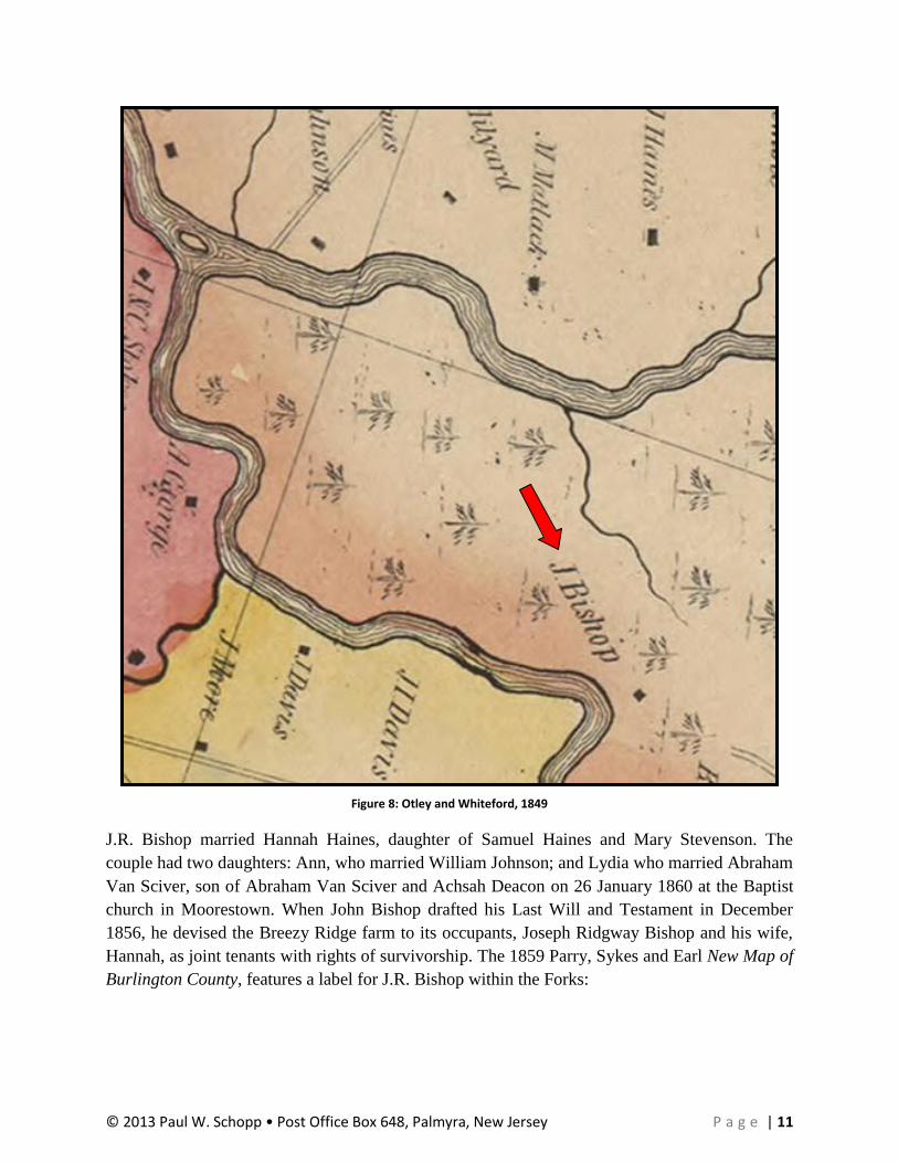
surveyed and drawn by cartographers J.W. Otley and R. Whiteford. This map shows only one
dwelling in the forks, labeled as “J. Bishop,” which could be either for Joseph Ridgway Bishop
or his father, John Bishop, the latter being the bona fide property owner. A detail of this map is
shown below, which also provides some indication that the bluff in the Forks featured tree cover:
2 Banked meadows entailed surrounding a marsh or meadow with earthen dikes or banks along a tidal stream.
Sluice boxes placed in the bottom of the earthen bank would allow collected water to run out into the stream at low tide, but block the introduction of any new water as the tidal flow returned through the use of a automatic gate device that closed via water coming up the sluice. The alluvial soil within the meadow provided a rich medium in which to grow crops and grazing grasses.
© 2013 Paul W. Schopp • Post Office Box 648, Palmyra, New Jersey P a g e | 11
Figure 8: Otley and Whiteford, 1849
J.R. Bishop married Hannah Haines, daughter of Samuel Haines and Mary Stevenson. The
couple had two daughters: Ann, who married William Johnson; and Lydia who married Abraham
Van Sciver, son of Abraham Van Sciver and Achsah Deacon on 26 January 1860 at the Baptist
church in Moorestown. When John Bishop drafted his Last Will and Testament in December
1856, he devised the Breezy Ridge farm to its occupants, Joseph Ridgway Bishop and his wife,
Hannah, as joint tenants with rights of survivorship. The 1859 Parry, Sykes and Earl New Map of
Burlington County, features a label for J.R. Bishop within the Forks:

© 2013 Paul W. Schopp • Post Office Box 648, Palmyra, New Jersey P a g e | 12
Figure 9: Parry, Sykes and Earl, 1859
Joseph R. Bishop died on 21 March 1861, but his father, John, made no changes to his own Will.
On 2 December 1863, John Bishop died and Hannah Haines Bishop, Joseph’s widow, gained full
ownership of Breezy Ridge farm, devised to her by her father-in-law (Haines 1961:94, 269).
Less than three months later, in February 1864, Hannah conveyed the farm to her daughter,
Lydia:
For and in consideration of the sum of one dollar and the natural love and
affection she hath for her daughter,” Hannah Bishop deeded to her daughter “The
farm, plantation or tract of land called and known by the name of Breezy Ridge
situated in the Twp. of Lumberton Burl. Co., Containing 165 79/100 acres more
or less. Also another tract of land containing 8 acres more or less. Subject never
the less, the 8 acres to the following conditions, that is that Hannah Bishop in
during her natural life to have and occupy and enjoy the 8 acres of land as may
seem to her best without any hindrance or molestation from her, Lydia Van
Sciver, or any other person acting under the authority and not suffer for the use of

© 2013 Paul W. Schopp • Post Office Box 648, Palmyra, New Jersey P a g e | 13
any firewood or any other thing while living or to any incumbrance to her other
daughter Ann Johnson, wife of William Johnson by reason where of that Anna
Johnson is to suffer any loss or expense incurred for Hannah Bishop’s good and
comfortable maintenance. (Miloszar 1976:98)
This transaction provided Abraham and Lydia Bishop Van Sciver with a place to live and raise
their family. The marriage produced five children: Joseph Bishop Van Sciver; George Dobbins
Van Sciver; Abraham D. Van Sciver; Annie Van Sciver; and Mary Carlisle Van Sciver (Miloszar
1976:98-99). Abraham contracted pneumonia and died in January 1871 (Miloszar 1976:97).
Subsequent to Abraham’s death, Lydia remarried to William Amos. The couple had two children
together: William and John Amos. The J.D. Scott 1876 Combination Atlas Map of Burlington
County depicts not only Lydia with her new married name, but also the presence of a second
dwelling in the Forks: the home of William A. Johnson and his wife Ann, Lydia’s sister (Haines
1961:270).
Figure 10: Scott, 1876
Riverdale
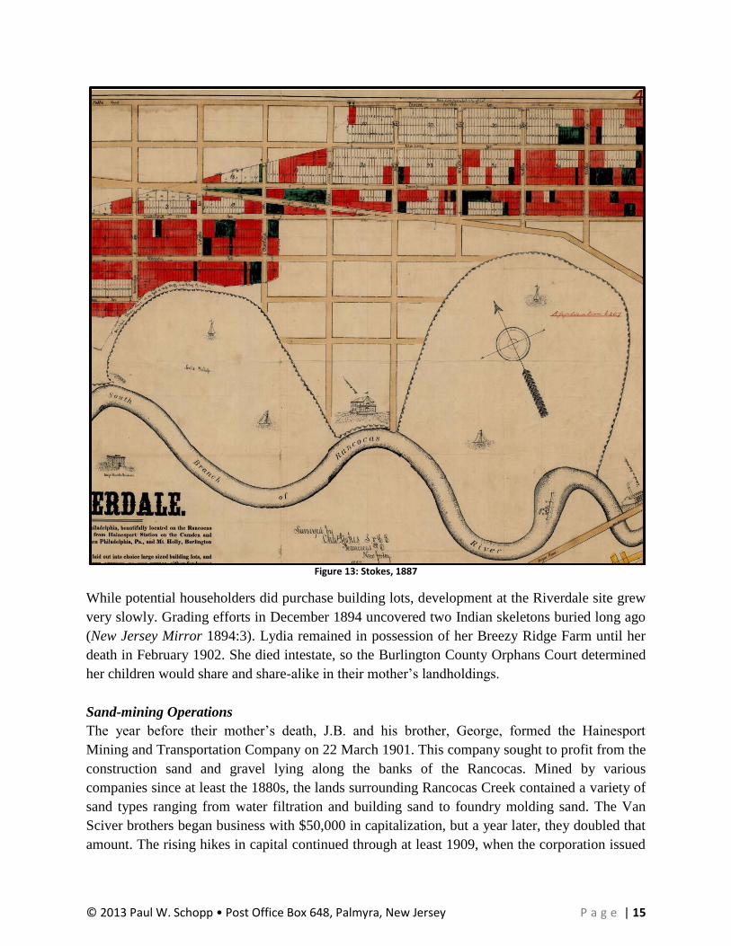
During the second half of the 1880s, a group of investors purchased the central eastern portion of
the peninsula formed within the Forks and platted a new subdivision named “Riverdale.” The
company prepared a map of their holdings, which delineates streets and building lots and labels
Lydia’s house as the “Amos Residence,” as shown in the detail below from the development
map:
© 2013 Paul W. Schopp • Post Office Box 648, Palmyra, New Jersey P a g e | 14
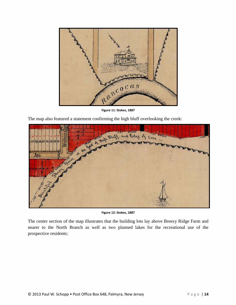
Figure 11: Stokes, 1887
The map also featured a statement confirming the high bluff overlooking the creek:
Figure 12: Stokes, 1887
The center section of the map illustrates that the building lots lay above Breezy Ridge Farm and
nearer to the North Branch as well as two planned lakes for the recreational use of the
prospective residents:
© 2013 Paul W. Schopp • Post Office Box 648, Palmyra, New Jersey P a g e | 15
Figure 13: Stokes, 1887
While potential householders did purchase building lots, development at the Riverdale site grew
very slowly. Grading efforts in December 1894 uncovered two Indian skeletons buried long ago
(New Jersey Mirror 1894:3). Lydia remained in possession of her Breezy Ridge Farm until her
death in February 1902. She died intestate, so the Burlington County Orphans Court determined
her children would share and share-alike in their mother’s landholdings.
Sand-mining Operations
The year before their mother’s death, J.B. and his brother, George, formed the Hainesport
Mining and Transportation Company on 22 March 1901. This company sought to profit from the
construction sand and gravel lying along the banks of the Rancocas. Mined by various
companies since at least the 1880s, the lands surrounding Rancocas Creek contained a variety of
sand types ranging from water filtration and building sand to foundry molding sand. The Van
Sciver brothers began business with $50,000 in capitalization, but a year later, they doubled that
amount. The rising hikes in capital continued through at least 1909, when the corporation issued
© 2013 Paul W. Schopp • Post Office Box 648, Palmyra, New Jersey P a g e | 16
stock valued at $600,000 (New Jersey Secretary of State 1914:281). Among other sand-bearing
lands, the Hainesport Mining and Transportation Company acquired all of the land at the Forks.
J.B. Van Sciver served as his administrator for his late mother’s intestacy and in August 1905,
J.B. and all of the other heirs of Lydia Amos’s estate sold multiple parcels of land in the Forks,
including building lots in Riverdale, to the Hainesport Mining and Transportation Company for
the nominal price of $1.00 (Burlington County Deed Book 399:444, 454). The company then
began sand-mining operations and, in the space of six to eight years, destroyed the lofty 30-foot-
high Breezy Ridge plateau, creating a virtual moonscape across the area. Many Indian artifacts
from the village that once occupied the bluff in the Forks disappeared into the sand scows
belonging to the company, never to be seen again.
In a 1910 report to Congress concerning conditions and the need to expend improvement funds
on the Rancocas Creek, the United States Army Corps of Engineers states the following:
The banks of the Rancocas and of both of its branches contain immense deposits
of building, filter, and molding sand. The deposits along the main stream and the
Lumberton branch have been largely developed, while those up the Mount Holly
branch have been hardly touched, owing to lack of navigation. The sand for some
of the filtration works of Philadelphia, to the amount of 268,000 tons, was secured
from beds located much more conveniently for shipment by water via the Mount
Holly branch than by rail, but followed the latter route as scows and tugs of
sufficient size could not go above the forks. It is estimated that the amount of sand
transported from the Lumberton branch and from below the forks amounts
annually to over 600,000 tons, of an average value of $1. (Rand 1910:5)
The same report contained letters of testimony from various businesses that would benefit from
improving navigation on the Rancocas, including one from George D. Van Sciver of the
Hainesport Mining and Transportation Company:
…Letter of the Hainesport Mining and Transportation Company
Hainesport, N.J., April 5, 1909
We believe that the river should be deepened at various places and straightened
at some points above what is known as the forks or the junction of the south and
north branches of the river. We find it very difficult to get our lighters and tugs to
our sand banks at Hainesport, N.J., on an average run of tide, and on a very low
run of tide impossible at times for a period of one to three days to move them at
all. This condition makes the cost of getting material to Philadelphia and other
points greater on account of increased freight charges.
Below you will find the quantity of gravel we carried out of the river, and its
cost, during 1908: 867 boat loads carrying an average of 300 cubic yards each at
40 cents per cubic yard, which includes the cost of material, making $104,040.
Carried to Hainesport from Philadelphia, 4,000 tons of pig iron at 43 cents per
ton, $1,892.
© 2013 Paul W. Schopp • Post Office Box 648, Palmyra, New Jersey P a g e | 17
Our business as well as others should be largely increased should we have a
deeper waterway and a straighter channel. We believe that if this were to be
accomplished manufacturing plans would be erected on the banks of the river as
they would be able to avail themselves of the low rate which could be provided.
Hainesport Mining and Transportation Company,
Geo. D. Van Sciver, President. (Rand 1910:10-11)
It appears sand-mining operations in the Forks ended between 1911 and 1913. Van Sciver’s
company had already acquired sand-bearing lands elsewhere along the creek, principally in
Chester and Willingboro townships (Burlington County Deed Book 482:341; 495:65, 140; 506:1;
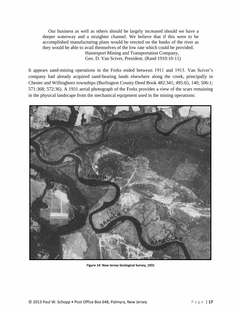
571:368; 572:36). A 1931 aerial photograph of the Forks provides a view of the scars remaining
in the physical landscape from the mechanical equipment used in the mining operations:
Figure 14: New Jersey Geological Survey, 1931

© 2013 Paul W. Schopp • Post Office Box 648, Palmyra, New Jersey P a g e | 18
In 1932, George D. Van Sciver contracted with Riverside surveyor Clement M. Anderson to
draft a map of the peninsula within the Forks, shown in its entirety on page 18. After mining the
sand from the land, Van Sciver took title to most of the tracts comprising the peninsula. The map
provides information about the excavation line, the placement of Riverdale, the wharves once
used for loading sand barges, and the location of marshlands along both branches of the
Rancocas Creek. The only standing structure indicated on the map is a bungalow, the old Read
dwelling having burned in the 1920s.
During the 1960s, the State of New Jersey acquired land in Westampton, Hainesport, and Mount
Laurel townships to create the Rancocas State Park, including the land in the Forks. The state
retains title to this land today as part of its statewide park system, although New Jersey has failed
to develop the land for recreational activities or as a Wildlife Management Area. Today, the land
within the Forks remains virtually as the Hainesport Mining and Transportation Company left it,
except for the vegetation that has grown during the intervening years. Mounds dot the landscape
in various locations around peninsula, formed when the sand-mining operations removed the
overburden and turf to expose the underlying sand. Plate 1 of the Township of Hainesport tax
parcel map set depicts the present layout of the peninsula in the Forks and can be viewed on page
20 of this report.

© 2013 Paul W. Schopp • Post Office Box 648, Palmyra, New Jersey P a g e | 19
Figure 15: Anderson, 1932

© 2013 Paul W. Schopp • Post Office Box 648, Palmyra, New Jersey P a g e | 20
Figure 16: Township of Hainesport, Revised to 1988

© 2013 Paul W. Schopp • Post Office Box 648, Palmyra, New Jersey P a g e | 21
Bibliography:
Anderson, Clement M.
1932 The Van Scivers Hainesport Property, Burlington Co., New Jersey. Manuscript map.
Burlington County Clerk’s Office Filed Plan no. 1554. Burlington County Clerk’s Office,
Mount Holly, New Jersey.
Brown, Lloyd A.
1949 The Story of Maps. Bonanza Books, New York City, New York.
Burlington County Deed Book
Burlington County deed books. Burlington County Clerk’s Office, Mount Holly, New
Jersey.
Burlington County Will Book
Burlington County will books. Burlington County Surrogate’s Office, Mount Holly, New
Jersey.
DeCou, George
1949 The Historic Rancocas. The News Chronicle, Moorestown, New Jersey.
Haines, John W.
1961 Richard Haines and His Descendants. Carr Publishing Company, Incorporated, Carr,
Virginia.
Herrman, Augustine
1673 Virginia and Maryland as it is planted and Inhabited this Present Year 1670. Augustine
Herrman and Thomas Withinbrook, London, England.
Hutchinson, Elmer T.
1946 Archives of the State of New Jersey: Documents Relating to the Colonial, Revolutionary
and Post-Revolutionary History of the State of New Jersey. First Series—Vol. XXXIX:
Calendar of New Jersey Wills, Administrations, Etc., Volume X—1801-1805. New Jersey
Historical Society, Newark, New Jersey.
Kraft, Herbert C.
1986 The Lenape: Archaeology, History, and Ethnology. New Jersey Historical Society,
Newark, New Jersey.
Miloszar, Charlotte Van Sciver
1976 Van Sciver Genealogy: Early Historical and Family Events. Reynolds Publishing, Cherry
Hill, New Jersey.
Myers, Albert Cook
1912 Narratives of Early Pennsylvania, West New Jersey, and Delaware. Charles Scribner’s
Sons, New York City, New York.
© 2013 Paul W. Schopp • Post Office Box 648, Palmyra, New Jersey P a g e | 22
Nelson, William
1899 Archives of the State of New Jersey: Documents Relating to the Colonial History of the
State of New Jersey. First Series—Vol. XXI: Calendar of Records in the Office of the
Secretary of State: 1664-1703. New Jersey Historical Society, Newark, New Jersey.
New Jersey Geological Survey
1931 Aerial photo quads of New Jersey. New Jersey Geological Survey, Trenton, New Jersey.
New Jersey Mirror
1894 “Little Things.” Published in the 26 December edition of the New Jersey Mirror.
Microform edition. New Jersey Mirror, Mount Holly, New Jersey.
New Jersey Secretary of State
1914 Corporations of New Jersey: List of Certificates to December 31, 1911. New Jersey
Secretary of State, Trenton, New Jersey.
Newkirk, Peggy Rose Wills
2001 Wills Ancestry in America. Buckeye Graphics, Worthington, Ohio.
Otley, J.W. and R. Whiteford
1849 Map of Burlington County. Smith & Wistar, Philadelphia, Pennsylvania.
Parry, William, George Sykes, and F.W. Earl
1859 New Map of Burlington County. R.K. Kuhn and J.D. Janney, Publishers, [Philadelphia,
Pennsylvania].
Pedrow, Richard
1969 Hainesport: Biography of a Small Town. Magee Publishing Company, Incorporated,
[Bordentown, New Jersey].
Rand, Captain L.H.
1910 Letter from the Secretary of War, Transmitting, with a Letter from the Chief of Engineers,
Reports on Examination and Survey of Rancocas River, New Jersey, from the Mouth to
Mount Holly. United States House of Representatives, 61st Congress, 2d Session,
Document No. 850. Government Printing Office, Washington, D.C.
Schopp, Paul W.
2010 “The Best Laid Schemes o’ Mice an’ Men, Gang aft Agley.” Original monograph e-
published here: http://jerseyman-historynowandthen.blogspot.com/2010/10/best-laid-
schemes-o-mice-men-gang-aft.html, accessed March 14, 2013.
Scott, J.D.
1876 Combination Atlas Map of Burlington County, New Jersey. J.D. Scott, Philadelphia,
Pennsylvania.

© 2013 Paul W. Schopp • Post Office Box 648, Palmyra, New Jersey P a g e | 23
Seller, John
1677 A Mapp of New Jersey in America. John Seller and William Fisher, London, England.
Stokes, Charles
1887 Riverdale. Published map of proposed development in Hainesport. n.p.
Swank, James Moore
1891 History of the Manufacture of Iron in All Ages: and Particularly in the United States
from Colonial Times to 1891. American Iron and Steel Association, Philadelphia,
Pennsylvania.
Township of Hainesport
1988 Tax Parcel Map, Plate 1. Township of Hainesport Tax Assessor, Hainesport, New Jersey.
Van Zandt, Cynthia J.
2008 Brothers Among Nations: The Pursuit of Intercultural Alliances in Early America, 1580-
1660. Oxford University Press, Incorporated, New York City, New York.
Vermeule, Cornelius C.
1878 Plate 64, original manuscript topographical maps of New Jersey. New Jersey Department
of Environmental Protection, Division of Water Supply and Geoscience, Trenton, New
Jersey.
Vinckeboons, Joan
c.1639 Cært vande Svydt Rivier in Niew Nederland. Manuscript map. Housed at the Library of
Congress, Washington, D.C.
Visscher, Nicolæs
c.1651 Novi Belgii Novæque Angliæ Novæ et Partis Virginæ. n.p.
Weslager, Cornelius
1961 Dutch Explorers, Traders and Settlers in the Delaware Valley, 1609-1664. University of
Pennsylvania Press, Philadelphia, Pennsylvania.
Woodward, Carl Raymond
1941 Ploughs and Politicks: Charles Read of New Jersey & His Notes on Agriculture, 1715-
1774. Rutgers University Press, New Brunswick, New Jersey.