the explorers game
TRANSCRIPT
THE EXPLORERS GAME
Scientific progress during the Renaissance made it ssible for Europeans to undertake voyages of exploration.
The following developments led to the discovery and colonization of the New World:
1. Travelers to China brought the compass back to Europe, enabling sea captains to sail beyond the sight of land.
2. A new type of rudder made it easier to steer ships on the ocean.
3. More accurate IDaP..S. were made based on the reports of early travelers and explorers.
4. Johannes Gutenberg of Germany invented movable type, which made it possible to arrange individual letters and print pages quickly and inexpensively. Earlier books were costly and limited in number because they had to be copied by hand. But now maps and travelers' tales._codd be circulated throughout Europe. Geographic knowledge and curiosity about distant lands increased.
5. During the 1200's, the Chinese invented ~powder. Visitors to China brought gunpowder back to Europe where it led to the development of cannons and muskets. These weapons helped the explorers conquer Indian tribes and establish empires in the New World.
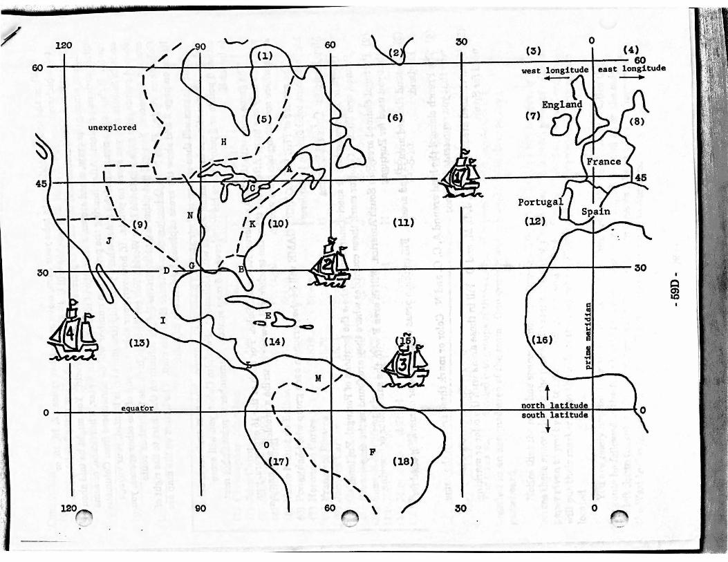
6. An instrument called the astrolabe helped explorei·s determine their latitude and longitude. The astrolabe measured the angles of stars above the horizon. It told sailors their exact position at sea.
Map Skills: Latitude and Lon~tude Latitude is the distance in degrees north or south of the equator. Latitude lines run across
on a map. Lonldtude is the distance in degrees east or west of the prime meridian. Longitude lines run up and down on a map. Latitude and longitude lines appear on the map on page 4. Use the map to answer the following questions.
(1) Ship 1 is located at Jf..5_ degret!s north latitude. (2) Ship 1 is located at __ degrees west longitude. (3) Ship 2 is located at __ degrees __ latitude.
(4) Ship 2 is located at __ degrees __ longitude.
(5) Ship_ is located at 15 degrees north latitude and 120 degrees west longitude.
Questions Use the information above and the facts on the chart on the next page to answer the
following questions.
True or False (1) __ _
(2) __ _ (3) __ _
( ) 4) __ _
(5) __ _
Explorers sailed to the New World during the Renaissance. The explorers were helped by inventions from outside of Europe. A compass is used to determine a ship's exact position at sea. Johannes Gutenberg's invention made it easier for the Europeans to conquer Indian tribes and establish empires. The French came to the New World before the English.
- 59A-
•;, .~

Completion (6) ______ _
,7) ______ _
(8) ______ _
-(9) -------
Did Spain claim most of its land in the New World during the 1400's, 1500's, or 1600's? What are the lines called that measure distance north or south of the equator? The name "America" comes from the first name of which Spanish explorer? The Vikings sailed along the coast of North America J:J.bout the year 1000. Was this before or .aft.el: the voyage of Columbus?
(10) -------- By the year 1550, which European country had established the largest empire in the New World?
Letter gfAr~a
Explorer ~ C2:unta Ex-glgr~d Rgute (1) Christopher Columbus 1492 Spain E 12-16-15-14 (2) John Cabot 1498 England K 7-3-2-6-10 <
·(3) Amerigo Vespucci 1499 Spain M 12-16-15-14 ( 4) Pedro Cabral 1500 Portugal F 12-16-18 (5) Vasco Nunez de Balboa 1513 Spain L 12-16-15-14 (6) Ponce de Leon 1513 Spain B 12-16-15-14-10 (7) Hernando Cortes 1519 Spain I 12-16-15-14-13 (8) Francisco Pizarro 1532 Spain 0 12-16-15-14-17 (9) Jacques Cartier 1534 France A 7-6-5 0) Cabeza de Vaca 1536 Spain D 12-16-15-14-13-9
(11) Francisco Coronado 1540 Spain J 12-16-15-14-13-9 (12) Samuel de Champlain 1608 France c 7-6-5 (13) Henry Hudson 1610 England H 7-6-1-5 (14) Marquette and Joliet 1673 France N 7-6-5-10 (15) Robert La Salle 1682 France G 7-6-5-10
( Total Poinis
Rules for THE EXPLORERS GAME
The class will be divided into groups of three or four students. These people will sit together in an assigned area of the room. One group member's map will be used as the game board.
£gint~
------------------------------
Notice that the map has spaces which are numbered from 1 to 18. You will be moving across these spaces during the game. To mark the space you are on, use a small piece of colored paper given to you by the teacher. Each player will have a different colored marker. Everyone will put their marker off to the side of the map where England, France, Spain, and Portugal are located.
You are ready now for the game to begin. Find Columbus on the chart above. Notice that ~e route he followed to the New World took him across spaces 12, 16, 15, and 14 on the map .
... e left Spain (in space 12), sailed across the Atlantic Ocean (spaces 16 and 15), and discovered the West Indies (in space 14). You will follow this same route to America.
- 59B-

/
I
When the teacher tells you to take your turn, move onto either space 12, 16, 15, or 14 -- whichever one you choose. The teacher will then describe one of the many hardships and lplgers faced by Columbus and the other explorers of the New World. You might be told about
..... .fckness among the crew, a bad storm, a shortage of food and fresh water, a hurricane, or some other serious problem. After hearing the problem, a number will be announced from Columbus' route. If this is the number of the space where your ship (the marker) is located, your voyage ends in failure and you score no points. If, however, your ship is in one of the other spaces, you score 4 points for a safe trip to the New World. You get 4 points because-Columbus' route crossed 4 spaces. You will put either a .0. or a {in the Points column on the chart to the right of Columbus' route. Then print Columbus next to letter E on the map. The letters on the map are listed on page 2 and show the areas explored by each sea captain. ·
All players will then return to their starting position in Europe. The next explorer is John Cabot. Play continues in the same way as with Columbus. For John Cabot, you will score either .0. points or 5. points since his route covers 5 map spaces. Remember to print Cabot next to letter K.
The game ends with the 15th explorer, Robert La Salle. For each of the-:15 explorers, you will take only one turn. After your tum, the teacher will always describe a problem and name a space where something has gone wrong.
The winner of THE EXPLORERS GAME will be the person in each group who has the highest point total for the 15 explorers.
Map Fxercise: Colonial EmPires
) Use four different colors or special markings to show the locations of Portugal, England, France, and Spain. Color or mark these countries where they are found on the map.
(2) Portugal claimed area F in South America. Fill in area F with the same color or marking th&t you used for Portugal.
(3) England claimed area H and area K. Fill in these areas with the color or marking used for J4~ngland.
(4) ·fhe French claimed the land around A, C, G, and N. Color or mark these areas in the same way that you represented France.
(5) Spain claimed areas B, D, E, I, J, L, M, and 0. Fill in these areas with the color or marking used for Spain.
- 59C-
~~···--
(4) 120 60 30 0 (3)
I r t I \. · ' I ' 1 I I 60 60 ;I" { "' - ._...... 1 ....... hut~ east longitude
unexplored
\ \ \
-·----,(9)
' J '
30 I \ ',.\:
(1.3)
120
' '
. ----.
England (6) (7) 0
(11) (12)
~\ ~~ 30
! "c:J .... I
0
~ ac