the explanation on cvimage and 3d map - iwane.com · the explanation on cv image and 3d map ... a...
TRANSCRIPT
The Explanation on
CV IMAGE and 3D MAPby all-surrounding-image
2009
Iwane Laboratories Ltd.
Contents
Forward
About CV (Camera Vector) Image
Shooting process
Complete all-surrounding-image
Various Application Technologies and Possibilities from CV Image
CV Application Technologies (Process and Practical Use)
Image linked with Map (Video GIS)
Stop Vibration Display (Control)
Evaluation of Comfort-Riding of Vehicle by Image Vibration Analysis
Analysis of Road Situation (Slope Data etc.) by Image Vibration Analysis
Display of Latitude Longitude and Altitude Data of Arbitrary Point
Three Dimensional Measurement in a Frame
Three Dimensional Measurement between Frames
Object Lock-on Display
Combination of Live Image and CG
Iconization and Attribute Registration of 3 Dimensional CG (CV Tag)
Iconization and Attribute Registration of Real Object Image
Flood Simulation
Simulation for Road Works Permission
Spectacle Examination
Automatic Generation of Ortho Image
Generation of CG from Object in CV Image, Manual Generation of 3D Map
New product ALV (Active Link Vision) as the total technology
of CV imaging technique
iiCosmo
Google Earth and ALV Link
Super Wide Angle Image
Applied Technique of CV (under developing)
RCG - Real Computer Graphics -
Background Deletion, Background Extraction
Automatic Generation of 3D CG from Video image.(Able to change View Direction of Image)
Moving Object Detection and Movement Analysis of Object
Real-time CG Composition
Vehicle Recognition
Object Recognition in 3D Space (Example:Automatic Recognition of Road Sign)
The Future of 3D Map using CV Image
The First Stage Processing of 3D Map with CV Image
The Second Stage Processing of 3D Map with CV Image
Latent Demand of Nationwide Road Database in 3D Map
Role of 3D Map and ALV in the Next Generation Car Electronics
1
2
4
5
6
6
6
6
7
8
9
9
10
10
11
11
12
12
13
13
14
14
15
17
18
19
20
20
21
22
23
24
25
26
27
27
28
28
29

Forward
Our company is aiming at the artificial intelligence achievement by eyes of the robot, that
is, sight information. A three-dimensional space analysis and a three-dimensional image
recognition from the image are being researched and developed as a present problem.
Here, we think about the application to the car electronics as the first application of the
artificial intelligence. The automatic guide device that leads to an automatic driving of the
vehicle in the future is thought as an immediate objective.
The accuracy of the position of vehicle running in three-dimensional space is required in
few centimeters level, in order to obtain an effective automatic guide to the vehicle and an
automatic driving.
Moreover, a three-dimensional map of equal accuracy is needed to compare with. In order
to achieve vehicle positional detection of this accuracy, our company developed the
technology that needs the camera position in high accuracy using all surrounding video
image.
The camera that our company used takes the mechanism that all-surrounding video image
is produced with the synthesis of the images acquired with each of the six CCD to acquire
high accuracy all-surrounding video image.
Our company originally develops the image data processing, the dynamic scene making, and
a series of technology until making of a surrounding all video image three dimensions from
the camera calibration, and advances the upgrade and the application and the technology
developments.
It is clear about the accuracy shortage in the real-time measurement of past GPS. And it is
used only for the outline position acquisition.
All-surrounding image generated by Mercator drawing method
1
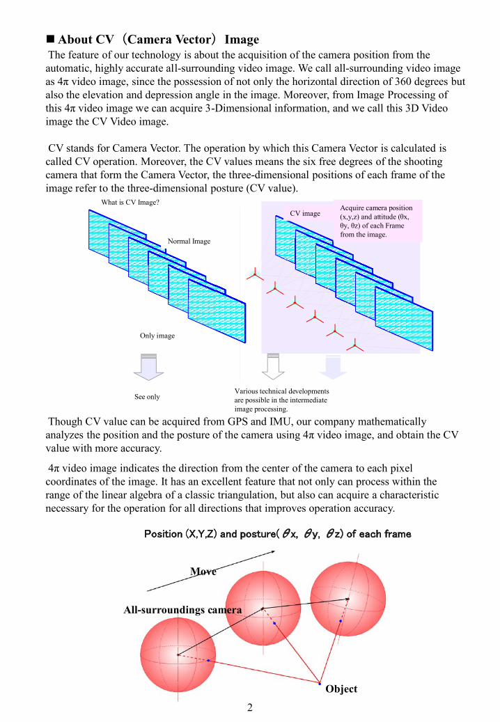
The feature of our technology is about the acquisition of the camera position from the automatic, highly accurate all-surrounding video image. We call all-surrounding video image as 4π video image, since the possession of not only the horizontal direction of 360 degrees but also the elevation and depression angle in the image. Moreover, from Image Processing of this 4π video image we can acquire 3-Dimensional information, and we call this 3D Video image the CV Video image.
CV stands for Camera Vector. The operation by which this Camera Vector is calculated is called CV operation. Moreover, the CV values means the six free degrees of the shooting camera that form the Camera Vector, the three-dimensional positions of each frame of the image refer to the three-dimensional posture (CV value).
All-surroundings camera
Object
Position (X,Y,Z) and posture(θx, θy, θz) of each frame
Though CV value can be acquired from GPS and IMU, our company mathematically analyzes the position and the posture of the camera using 4π video image, and obtain the CV value with more accuracy.
4π video image indicates the direction from the center of the camera to each pixel coordinates of the image. It has an excellent feature that not only can process within the range of the linear algebra of a classic triangulation, but also can acquire a characteristic necessary for the operation for all directions that improves operation accuracy.
C V 映 像
通 常 映 像
各フレームに対応する
カメラ位置( X ,Y ,Z)と
姿勢(θ x,θ y ,θ z)を
画像から取得
CV映像とは
映 像 の み
見 る だ け中間処理映像として様々な技術展開が可能
2
About CV(Camera Vector)Image
Move
What is CV Image?
Normal Image
Only image
See only
CV imageAcquire camera position (x,y,z) and attitude (θx, θy, θz) of each Frame from the image.
Various technical developments are possible in the intermediate image processing.

In addition, it is unnecessary to use many cameras, only a single camera is enough to obtain CV Image. The CV operation has an excellent feature that the device is extremely simplified so that it is possible to process fundamentally with a single camera.
Three-dimensional data of camera position (X,Y,Z) and posture (θx, θy, θz) corresponding to each frame of the image are requested by this method through out all frames of the image. It is added to the image data. And the new concept of CV image, that is all-surrounding image with CV value is acquired.
When each frame of the image had the CV value, the image can become three dimensional at any time. Therefore the CV image can be referred to as 2.5 dimension image.
Since the camera position and the posture in all frames become already-known, it is possible to read three-dimensional coordinates and three-dimensional shape of the object which is caught from a wide-ranging viewpoint by the camera. Moreover, the image can be treated just like CG. So various processes of image become possible which is an excellent feature.
Camera Vector (CV Value) and Image Feature Points extracted from CV Value and Image
3

The unique feature of our company is that it is possible to take video using only one camera and one PC. The expensive devices like GPS or IMU is not required to use ourthree dimensional technology.
This all-surrounding-camera hassix CCD lens.
After setting the camera up on the car,Shooting is started.
PC’s setting up is very easy. Shooting scene
While confirming the screen image,the setting is adjusted in real time.
The shooting staff is taking video alongwith confirming all situations such as theWeathers, road slope, etc.
4
Shooting process
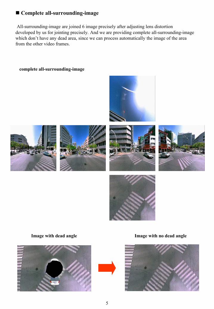
Complete all-surrounding-image
All-surrounding-image are joined 6 image precisely after adjusting lens distortiondeveloped by us for jointing precisely. And we are providing complete all-surrounding-image which don’t have any dead area, since we can process automatically the image of the area from the other video frames.
complete all-surrounding-image
Image with dead angle Image with no dead angle
5

Various applied technologies and possibilities from CV imageThe technology related to the CV image that our company has developed up to now to achieve the Artificial Intelligence level has the potential of solving technical problems and too much manufacturing cost of the Artificial Intelligence achievement that has been assumed to be difficult up to now. Our company is producing many application technologies concerning CV Image as follow.
CV Application Technologies (Process and Practical use)
Image linked with Map (Video GIS)Our company has delivered results of about 8,000 km of 4π image and CV image to the National Road Office of the Ministry of Land and Transport. This is the system that the GIS map can link with the image. It is used for the road maintenance management and the traffic safety measurement etc.
Stop Vibration Display (Control)The vibration in three dimensions of the camera when shooting the video can be detected in high accuracy by the CV operation. The application to detect the vibration information from the image that doesn't use the sensor can be expected. Moreover, it is also possible for the display to stop the vibration of the image base on the vibration data and to control the vehicle where the camera is fixed according to the vibration data in real time acquired, and lead to the possibility to stop the vibration of the vehicle in the future.
揺れ検出量
-0.8
-0.6
-0.4
-0.2
0
0.2
0.4
0.6
0.8
1
0 98 196
294
392
490
588
686
784
882
98010
7811
7612
7413
7214
7015
6816
6617
6418
6219
6020
5821
5622
5423
5224
5025
4826
4627
4428
4229
4030
3831
3632
3433
3234
3035
2836
2637
2438
2239
2040
18
frame
回転
量差
分(deg
/frame)
x
y
z
揺れ止め制御
-0.8
-0.6
-0.4
-0.2
0
0.2
0.4
0.6
0.8
1
0 98 196
294
392
490
588
686
784
882
98010
7811
7612
7413
7214
7015
6816
6617
6418
6219
6020
5821
5622
5423
5224
5025
4826
4627
4428
4229
4030
3831
3632
3433
3234
3035
2836
2637
2438
2239
2040
18
frame
回転
量差
分(deg
/frame)
x
y
z
6
Amount of vibration detection
Stop vibration control
Rotation am
ount different (degree/frame)
Rotation am
ount different (degree/frame)

Evaluation of Comfort-Riding of Vehicle by Image Vibration analysisWe can use the feature so that the vibration of the vehicle can be evaluated as three dimensional vibration of the camera can be detected. And it is possible to apply to evaluation of the roughness of the road side and the evaluation of the riding comfort of the vehicle. Furthermore, a driving simulator that reproduces even the vibration can be achieved.
Example of the combination of CG and real video image, and achievement to reproduce the vibration situation of vehicle by the vibration of CG
7

Analysis of road situation (Slope data etc.) by Image Vibration AnalysisIt is possible to investigate on the road side like the examination of the road inclination etc. by using the ability to detect the three dimensional vibration of the camera on the vehicle.
Plotting inclination data in Ortho image made from the CV image. (unit %)
8
Average road inclination for every 20m
Distant from origin (m)
Average road inclination (%
)

Display of Latitude Longitude and Altitude Data of Arbitrary PointBecause the CV image has the camera coordinates, each pixel has the relation to the camera coordinates due to the right-angled coordinate system. Especially, if the CV image is calibrated using three or more reference points, it will be possible to display an arbitrary point in the CV image by public coordinates. Naturally, if we use GPS when the video is shoot, we can make CV image with public coordinates.
Three Dimensional Measurement in a FrameBecause each frame of the CV image has the camera position, the coordinates at an arbitrary point of any frame can be acquired, and measuring the distance between two arbitrary points become possible.
9

Object Lock-on DisplayBecause any object in the CV image has the three-dimensional coordinates, it is possible to observe it by fixing the object that move, as playing video, to an arbitrary position in the picture frame. For instance, it is possible to display a target object by always fixing it in the image to the center of the picture frame. Moreover, not just display and observe an object, it is also possible to measure and analyze at the fixed position in which it displays.
Three Dimensional Measurement between FramesBecause each frame of the CV image has the camera position, the distance between each frame becomes already-known. Moreover, each pixel in each frame becomes already-known, and the distance between two arbitrary points between arbitrary frames can be acquired by calculation. All frames of the image are related in three-dimensional space by the CV value.
Specify start point of measurement Specify end point of measurement
Play video until the point of measurement comes near then specify it.
10

Combination of Live Image and CGSince the camera position is acquired by the operation, we can put a CG into a position observed from the already known camera position. And the CG and the video can be combined without any contradiction.
Iconizing and Attribute Registration of 3 Dimensional CG (CV Tag)A three-dimensional icon can be put on a target object by a synthetic function of the image and CG. So the object can be used as an icon. By clicking CG icon in the image, it is possible to display resulting Webpage or add related arbitrary attribute data to the CG icon.
Example of the synthesis display of CV image and CG
A target object is shown with the arrow icon.
The name of the street is displayed on three-dimensional signboard.
The CG signboard of a target building is arranged in the space.
CG arrows in the image in the retrieval result.
Various guide use
11
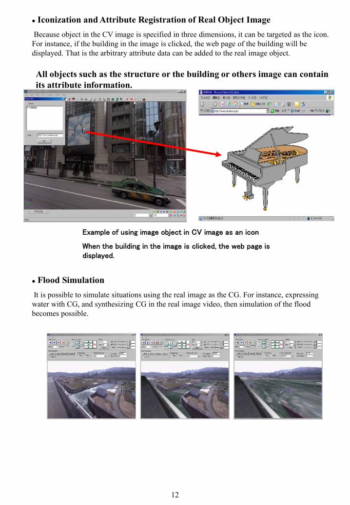
Flood SimulationIt is possible to simulate situations using the real image as the CG. For instance, expressing water with CG, and synthesizing CG in the real image video, then simulation of the flood becomes possible.
Iconization and Attribute Registration of Real Object ImageBecause object in the CV image is specified in three dimensions, it can be targeted as the icon. For instance, if the building in the image is clicked, the web page of the building will be displayed. That is the arbitrary attribute data can be added to the real image object.
All objects such as the structure or the building or others image can contain its attribute information.
Example of using image object in CV image as an icon
When the building in the image is clicked, the web page is displayed.
12
Spectacle Examination
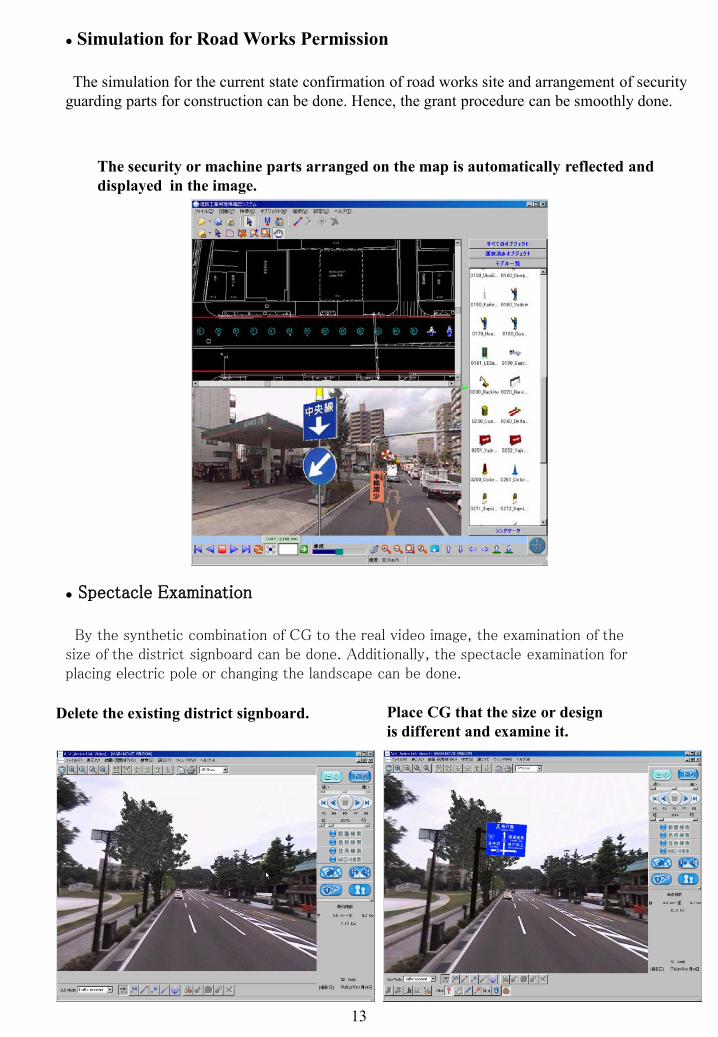
By the synthetic combination of CG to the real video image, the examination of the size of the district signboard can be done. Additionally, the spectacle examination for placing electric pole or changing the landscape can be done.
Simulation for Road Works Permission
The simulation for the current state confirmation of road works site and arrangement of security guarding parts for construction can be done. Hence, the grant procedure can be smoothly done.
The security or machine parts arranged on the map is automatically reflected and displayed in the image.
Delete the existing district signboard. Place CG that the size or design is different and examine it.
13
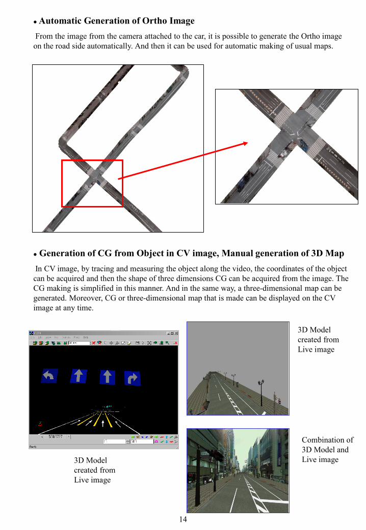
Automatic Generation of Ortho ImageFrom the image from the camera attached to the car, it is possible to generate the Ortho image on the road side automatically. And then it can be used for automatic making of usual maps.
Generation of CG from Object in CV image, Manual generation of 3D MapIn CV image, by tracing and measuring the object along the video, the coordinates of the object can be acquired and then the shape of three dimensions CG can be acquired from the image. The CG making is simplified in this manner. And in the same way, a three-dimensional map can be generated. Moreover, CG or three-dimensional map that is made can be displayed on the CV image at any time.
3D Model created from Live image
Combination of 3D Model and Live image3D Model
created from Live image
14

New product ALV (Active Link Vision) as the Total Technology of CV Imaging TechniqueALV (Active Link Vision) is the product that covers all CV image basic technologies. It is theproduct with the library of general-purpose that combines and make use of various above-mentioned technologies.
15
GPS Receiver
Display latitude longitude of GPS
Using ALV as a car navigation systemBesides the above-mentioned technology, the basic techniques that will be developed in the
future is designed to be assembled. For instance, ALV is managed by the absolute coordinate. Then if coordinates of the vehicle are input, it is possible to use it as a car navigation system.
Example of ALV display (Map、aerophotograph, and two or more CV images)
Example of ALV display (Map、CV Image)
ALV CG Combination ALV Measurement
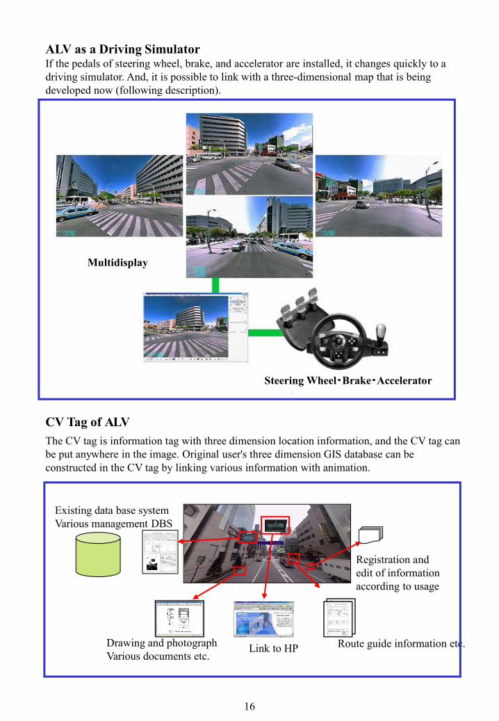
The CV tag is information tag with three dimension location information, and the CV tag can be put anywhere in the image. Original user's three dimension GIS database can be constructed in the CV tag by linking various information with animation.
Existing data base systemVarious management DBS
Route guide information etc.Drawing and photographVarious documents etc.
Registration and edit of information according to usage
Link to HP
16
ALV as a Driving SimulatorIf the pedals of steering wheel, brake, and accelerator are installed, it changes quickly to a driving simulator. And, it is possible to link with a three-dimensional map that is being developed now (following description).
Multidisplay
Steering Wheel・Brake・Accelerator
CV Tag of ALV
Multidisplay
Steering Wheel・Brake・Accelerator

◆ iiCosmo
It is being proposed to achieve the basic technique of the CV image on Web and to enhance the Two-Dimension self-proliferation type Database(Web2.0) achieving on the map Database, to the space of Three-Dimension.It is being opened as Alpha test version.
iiCosmo screen on Web All-surround 360°image can be operated
CV Tag diversity
In the image, various CV Tags(3DCG ) can be set up.
Searching CV Tag , jumping to CV Tag is also possible.
Registration of CV Tag information by user.It is possible to make communication on Web.
17
CV Tag is directly accessible from/to other Web sites.
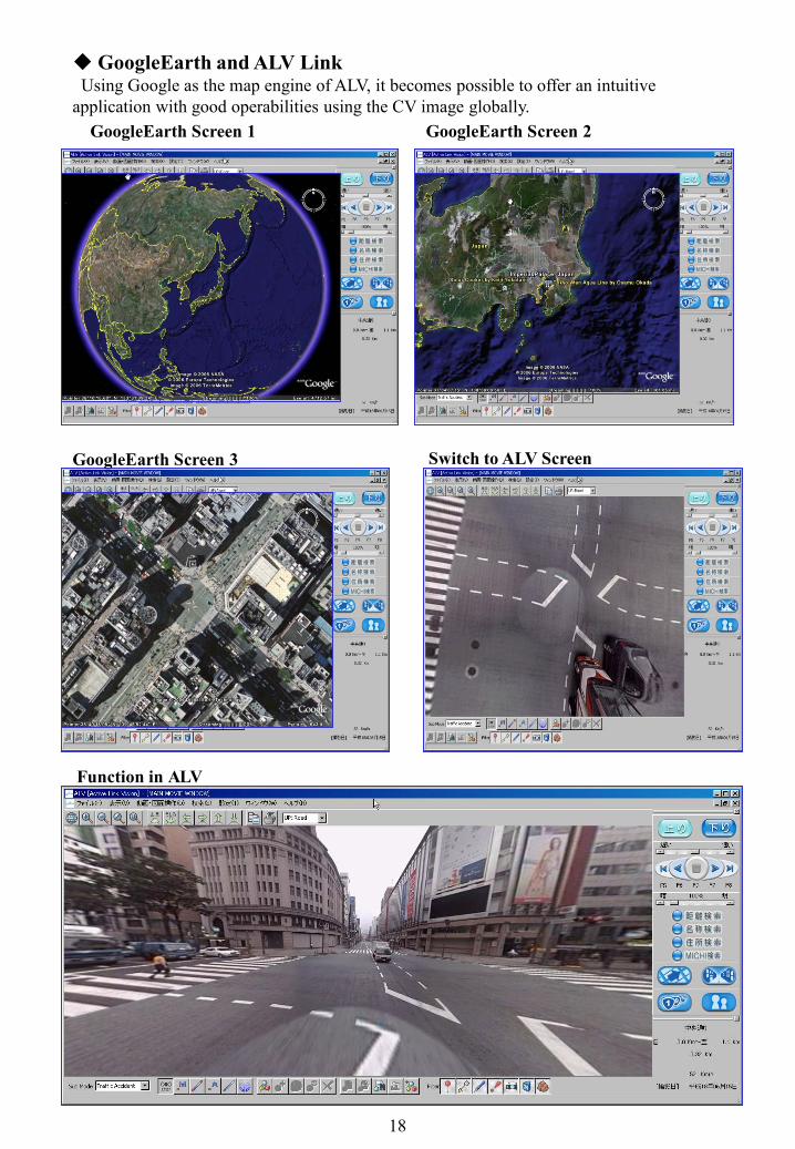
GoogleEarth and ALV LinkUsing Google as the map engine of ALV, it becomes possible to offer an intuitive
application with good operabilities using the CV image globally. GoogleEarth Screen 1 GoogleEarth Screen 2
GoogleEarth Screen 3 Switch to ALV Screen
Function in ALV
18
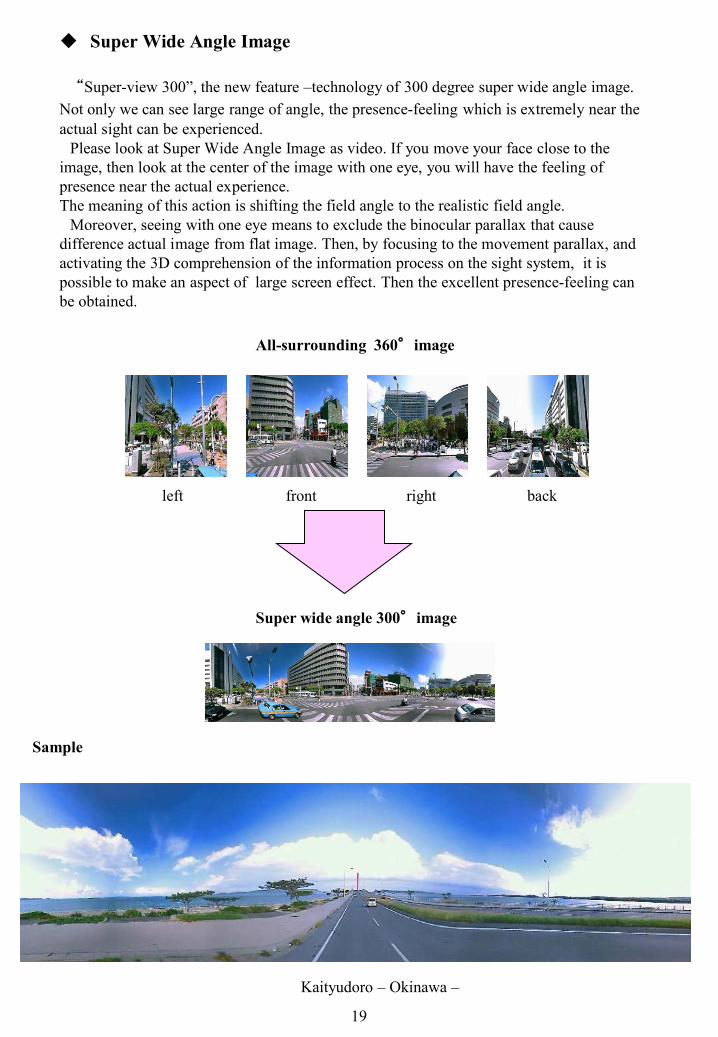
Super Wide Angle Image
“Super-view 300”, the new feature –technology of 300 degree super wide angle image.Not only we can see large range of angle, the presence-feeling which is extremely near theactual sight can be experienced.
Please look at Super Wide Angle Image as video. If you move your face close to the image, then look at the center of the image with one eye, you will have the feeling of presence near the actual experience.The meaning of this action is shifting the field angle to the realistic field angle.
Moreover, seeing with one eye means to exclude the binocular parallax that cause difference actual image from flat image. Then, by focusing to the movement parallax, and activating the 3D comprehension of the information process on the sight system, it is possible to make an aspect of large screen effect. Then the excellent presence-feeling can be obtained.
Kaityudoro – Okinawa –
Sample
All-surrounding 360°image
Super wide angle 300°image
front backleft right
19
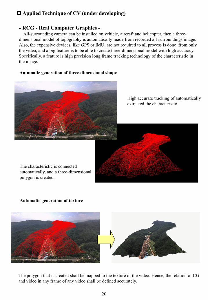
RCG - Real Computer Graphics -All-surrounding camera can be installed on vehicle, aircraft and helicopter, then a three-
dimensional model of topography is automatically made from recorded all-surroundings image. Also, the expensive devices, like GPS or IMU, are not required to all process is done from only the video, and a big feature is to be able to create three-dimensional model with high accuracy.Specifically, a feature is high precision long frame tracking technology of the characteristic in the image.
Applied Technique of CV (under developing)
20
High accurate tracking of automatically extracted the characteristic.
Automatic generation of three-dimensional shape
The characteristic is connected automatically, and a three-dimensional polygon is created.
Automatic generation of texture
The polygon that is created shall be mapped to the texture of the video. Hence, the relation of CGand video in any frame of any video shall be defined accurately.
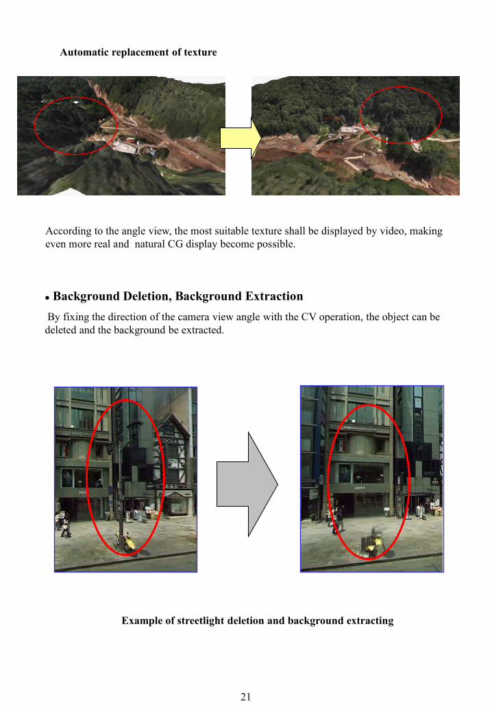
Background Deletion, Background ExtractionBy fixing the direction of the camera view angle with the CV operation, the object can be deleted and the background be extracted.
Example of streetlight deletion and background extracting
21
Automatic replacement of texture
According to the angle view, the most suitable texture shall be displayed by video, makingeven more real and natural CG display become possible.
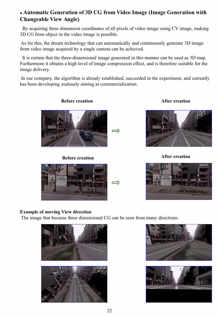
Automatic Generation of 3D CG from Video Image (Image Generation with Changeable View Angle)By acquiring three dimension coordinates of all pixels of video image using CV image, making
3D CG from object in the video image is possible.
As for this, the dream technology that can automatically and continuously generate 3D image from video image acquired by a single camera can be achieved.
It is certain that the three-dimensional image generated in this manner can be used as 3D map. Furthermore it obtains a high level of image compression effect, and is therefore suitable for the image delivery.
In our company, the algorithm is already established, succeeded in the experiment, and currently has been developing zealously aiming at commercialization.
Before creation
Before creation After creation
After creation
Example of moving View directionThe image that became three dimensional CG can be seen from many directions.
22
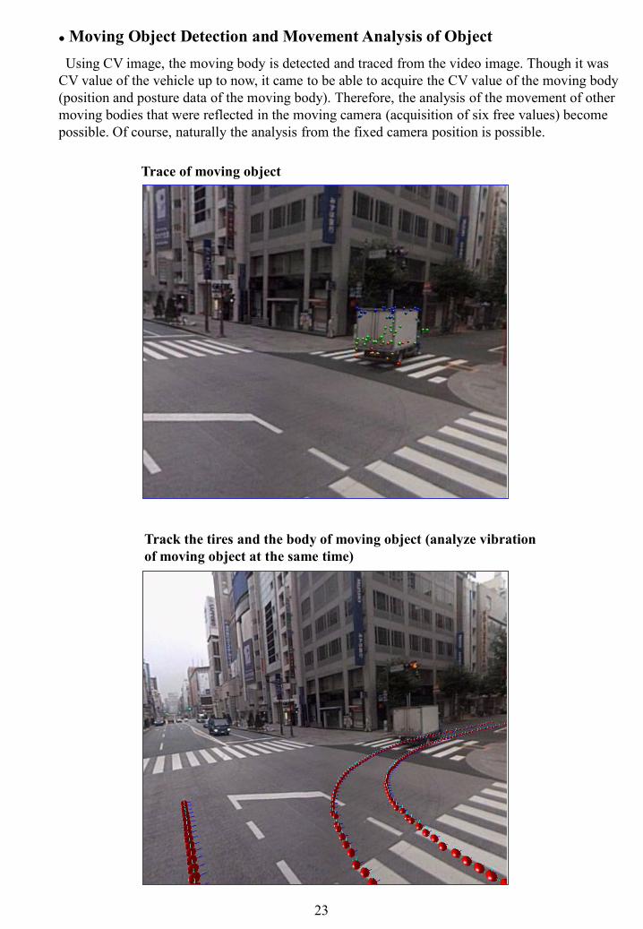
Moving Object Detection and Movement Analysis of ObjectUsing CV image, the moving body is detected and traced from the video image. Though it was
CV value of the vehicle up to now, it came to be able to acquire the CV value of the moving body (position and posture data of the moving body). Therefore, the analysis of the movement of other moving bodies that were reflected in the moving camera (acquisition of six free values) become possible. Of course, naturally the analysis from the fixed camera position is possible.
Trace of moving object
Track the tires and the body of moving object (analyze vibrationof moving object at the same time)
23
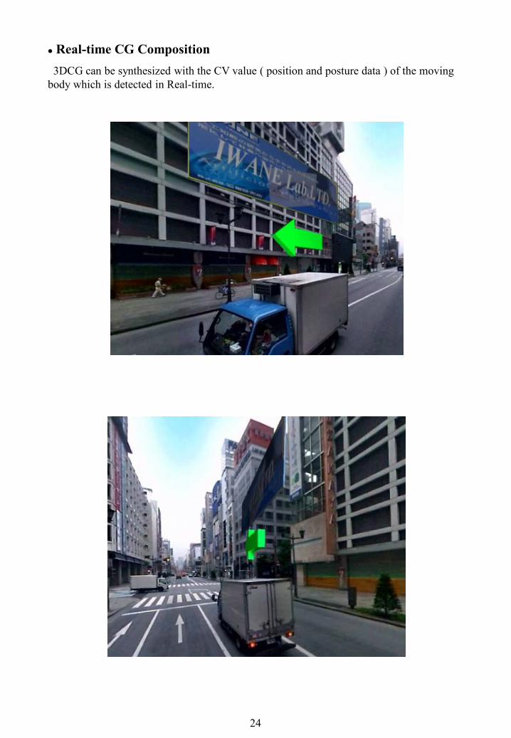
Real-time CG Composition3DCG can be synthesized with the CV value ( position and posture data ) of the moving
body which is detected in Real-time.
24
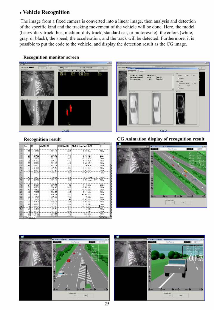
Vehicle RecognitionThe image from a fixed camera is converted into a linear image, then analysis and detection of the specific kind and the tracking movement of the vehicle will be done. Here, the model (heavy-duty truck, bus, medium-duty truck, standard car, or motorcycle), the colors (white, gray, or black), the speed, the acceleration, and the track will be detected. Furthermore, it is possible to put the code to the vehicle, and display the detection result as the CG image.
Recognition result CG Animation display of recognition result
Recognition monitor screen
25

Object Recognition in 3D Space (Example: Automatic Recognition of Road Sign) The object can be automatically recognized by using the CV image and analyzing the space in advance, specifying the recognition object and the retrieval range. The recognized object can have three-dimensional position information as public coordinates. And the automation of the image recognition and the three-dimensional map generation can become possible.
Display meaning of road signboard
The recognition result is translated to CG
26
The Future of 3D Map using CV ImageThough the image is used to see, it can be said that "CV image" is an image not only to see, but also to measure it.
Therefore, the CV image can be used as a three-dimensional map as it is, and can be assumed to be a three dimension map of multipurpose by further process according to the purpose. Especially, when examining it on the aspect to use the CV image as three dimension map, the following processing stages are to be considered.
The First Stage Processing of 3D Map with CV Image
by shooting video of real image, giving the CV processing, creating "CV image", andinstalling it in PC to carry it anywhere, various applications came to be considered as three-dimensional map .For example, by installing the construction site in PC as "CV image" to carries about, ones canspecify one arbitrary point in the image and make it displays the latitude longitude altitudevalue, measure in the three-dimensional space between two points not only in the same framebut also between many frames anytime and anywhere. Since it treats the image like CG,generating CG from the image and the combination of the image and CG becomes possible.And the simulation by changing the condition and setting various expectation landscape in thevideo in the design phase becomes possible.Moreover, because the object in "CV image" can specify coordinates as much as CG, the
attribute can be added to the object in the image. The attribute can be recorded, retrieved, anddisplayed by specifying the object in the image with a word.If "CV image" is delivered to the car navigation as an example, a three-dimensional of the
place measurement, the building in the image, and the attribute data of facilities can beinstantaneously acquired.In addition, because "CV image" has the function as a three-dimensional map, taking a real-
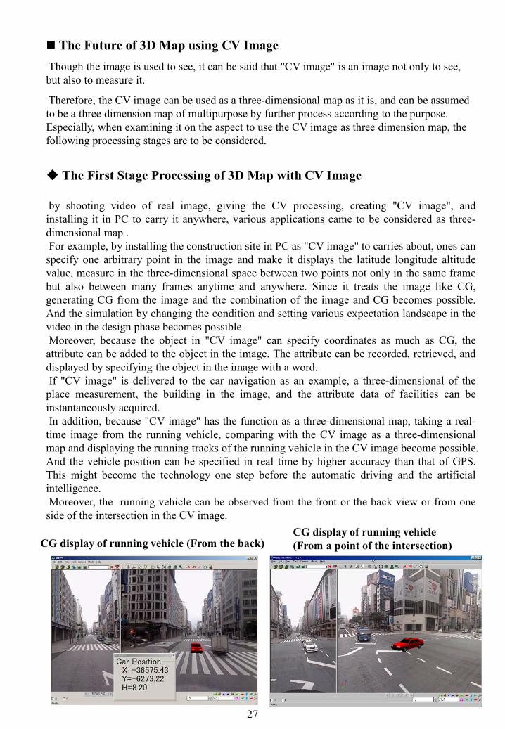
time image from the running vehicle, comparing with the CV image as a three-dimensionalmap and displaying the running tracks of the running vehicle in the CV image become possible.And the vehicle position can be specified in real time by higher accuracy than that of GPS.This might become the technology one step before the automatic driving and the artificialintelligence.Moreover, the running vehicle can be observed from the front or the back view or from one
side of the intersection in the CV image.
CG display of running vehicle (From the back)CG display of running vehicle (From a point of the intersection)
27

The Second Stage Processing of 3D Map with CV ImageIf the aim is to automatically compare the Camera Vector loaded on the vehicle with a three-dimensional map, and to obtain the accurate position of the vehicle, the majority of the images can be omitted from what man need not see. The Road Traffic Sign that relates to traffic in CV image, the Road Sign, and the destination guidance board etc. are recognized beforehand. And their three-dimensional coordinates and attribute and the CV image that records three-dimensional coordinates of the characteristic part that becomes the clue of coordinates in the CV image can be used as a three-dimensional map.
Since the considerable volume of data decrease from the CV image in the first stage, it becomes easier to treat. The image taken as real-time image by the computer on the vehicle is compared with this three-dimensional map. And the present position and posture can be obtained in high accuracy. Then it becomes possible to compare the information such as road signs with the information recorded to the three-dimensional map, then confirm and report to the vehicle controller. Moreover, the road inclination can be understood beforehand according to the CV value, and the load of the engine can be controlled.
A three-dimensional map can compare the road signs etc. in the image taken real-time, with not only the positions but also the attributes. Then automatic update of data becomes possible too.
The update of 3D Map in this second stage will be automated. Once the data are made they will be used and updated automatically after that.
3-Dimensional Map when considering practicality
To our company, it is considered that the highest practicality of the near future on the three-dimensional map is the synthetic combination of the above-mention first stage process and the above-mentioned second stage process. And the development is currently advancing.
It is 3D Map that is used by computers, automatic update is possible, and in the same time, is designed to be seen and understood by human.
Latent Demand of Nationwide Road Database in 3D MapWhen thinking about the near future, there is the necessity of the nationwide road
Database in three-dimensional map construction and design.
The Database in the three-dimensional map is there, and the above-mentioned automatic update technology is waited for. Then the world in the three-dimensional map is coming soon.
We thinks that 3D Map will be used as a platform of the industry in each field of the near future. Its value will be more than a present map and its existent will become necessary.
A three-dimensional map differs from the map in the past. It links with the real world as it is, and comes to be used seamlessly with the real world. A three-dimensional map is different from the concept of a current map because it completely corresponds to the real world. A new concept seems to arise there. The way of use will be not like before also. And it is clear that the first use will be related to the vehicle.
28
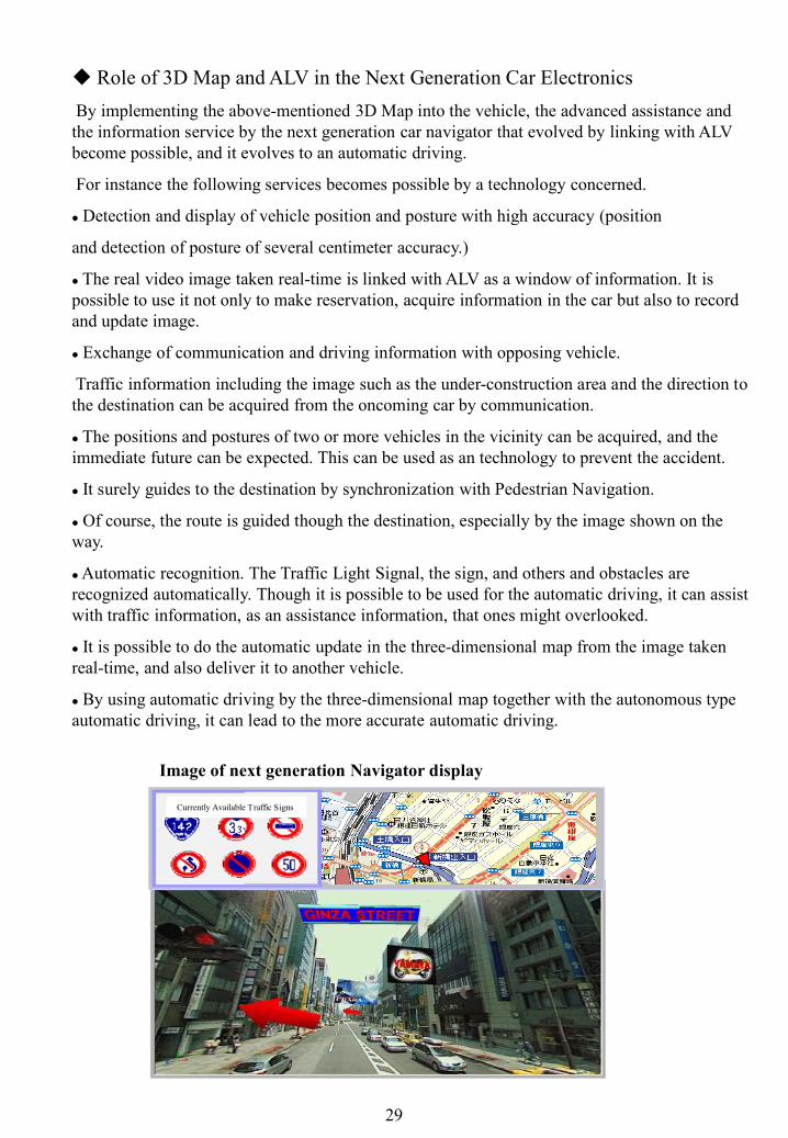
Role of 3D Map and ALV in the Next Generation Car ElectronicsBy implementing the above-mentioned 3D Map into the vehicle, the advanced assistance and the information service by the next generation car navigator that evolved by linking with ALV become possible, and it evolves to an automatic driving.
For instance the following services becomes possible by a technology concerned.
Detection and display of vehicle position and posture with high accuracy (position
and detection of posture of several centimeter accuracy.)
The real video image taken real-time is linked with ALV as a window of information. It is possible to use it not only to make reservation, acquire information in the car but also to record and update image.
Exchange of communication and driving information with opposing vehicle.
Traffic information including the image such as the under-construction area and the direction to the destination can be acquired from the oncoming car by communication.
The positions and postures of two or more vehicles in the vicinity can be acquired, and the immediate future can be expected. This can be used as an technology to prevent the accident.
It surely guides to the destination by synchronization with Pedestrian Navigation.
Of course, the route is guided though the destination, especially by the image shown on the way.
Automatic recognition. The Traffic Light Signal, the sign, and others and obstacles are recognized automatically. Though it is possible to be used for the automatic driving, it can assist with traffic information, as an assistance information, that ones might overlooked.
It is possible to do the automatic update in the three-dimensional map from the image taken real-time, and also deliver it to another vehicle.
By using automatic driving by the three-dimensional map together with the autonomous type automatic driving, it can lead to the more accurate automatic driving.
Image of next generation Navigator display
29
Currently Available Traffic Signs
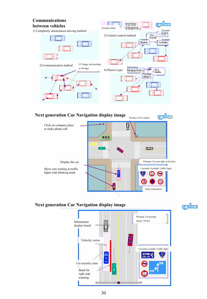
Communications between vehicles
Next generation Car Navigation display image
Next generation Car Navigation display image
30
Click on company place to make phone call
Display the car
Show cars waiting at traffic lights with blinking mark
Position of fix camera
Warning: Car turn right at the front
Currently Available Traffic Signs
Rules Information
Information display board
Velocity vector
Car security zone
Band for right side warning
Currently available Traffic Signs
Warning: Car passing
Speed: 140 km
1) Completely autonomous moving method
2) Communication method CV Image with attribute
or 3D Map
Normal vehicle
AutoDriving
CarNavigation
3) Central control methodTerminal Center
Terminal Center
Terminal Center
4) Passive typeInformation detection device
Terminal Center
Base Station
Terminal
Base Station