the enduring common operating picture - the … · web viewthe enduring common operating picture...
TRANSCRIPT

The Enduring Common Operating Picture
4/16/2013
Plans & Strategy Document

The Enduring Common Operating Picture
Table of ContentsDOCUMENT HISTORY..................................................................2HISTORICAL PERSPECTIVE..........................................................3BACKGROUND DOCUMENTS........................................................4INTRODUCTION..........................................................................5COMMON OPERATING PICTURE SUPPORT DECISIONS...................5Contracted Support...................................................................................5Organic Support........................................................................................5Recommendation......................................................................................6
COMMON OPERATING PICTURE...................................................6UL/UC2......................................................................................................7WebEOC – Mapper Professional 3.0..........................................................7Air Force Incident Manager (AFIM)............................................................8Installation Incident Manager (Proposed)..................................................9Recommendation....................................................................................10
OTHER CONSIDERATIONS.........................................................10External Data Access..............................................................................11Mobile Data Collection............................................................................11Data Standards.......................................................................................11Data Backups..........................................................................................12Redundancy............................................................................................12More Considerations...............................................................................12
DEPLOYMENT TIMELINE............................................................13INTERFACE EXAMPLES..............................................................13Security Forces Incident C2.....................................................................14Fire Department Incident C2...................................................................15
ADDITIONAL AREAS OF INTEREST..............................................16PROPOSED INFRASTRUCTURE LAYOUT......................................17VMWare...................................................................................................17SharePoint Dashboard............................................................................17Data Redundancy....................................................................................17SIPR Deployment....................................................................................18
CONCLUSION............................................................................18
Page 1

The Enduring Common Operating Picture
Page 2

The Enduring Common Operating Picture
DOCUMENT HISTORYVersio
n Date Description Author Approved By
1.0 April 16, 2013 Initial Concept & Plan
Pending Approval
Page 3

The Enduring Common Operating Picture
HISTORICAL PERSPECTIVEThe COP is the primary source of spatial information when responding to any incident for an installation. While the name has changed over the years, the commander’s goal for any COP has remained the same, to obtain the best picture possible.In September of 2009, most installations COPs were found to be deficient to meet the intent of the Emergency Communication Center Enabling Concept memo published by Col Curt A. Van De Walle then Chief of Readiness and Emergency Management Division DCS/Logistics Installations & Mission Support, and Col Tracey M. Heck then Deputy Chief of Force Protection and Operations Division DCS/Logistics Installations & Mission Support. This memo directed Civil Engineer (CE) Unit and Security Forces (SFS) commanders to establish virtual or co-located Joint Emergency Communication Centers (ECC) where Medical, Fire, and Security Forces personnel operated hand in hand. Many installations did not either have the space, funding, or both to meet the requirements outlined in Phase 2, within that fiscal year or for several to come, but Phase 1’s requirements were to leverage existing information systems technologies to establish a virtual ECC within 90 days of the memo being published. The attachment to the memo, ECC Enabling Concept white paper, directed the improvement of communication flow during an emergency situation by ensuring installation leadership was provided a single point of information, a dashboard that included a single COP shared among commanders.In the past, emergency command centers such as the Base Defense Operations Center (BDOC) would run several different applications to meet their requirements, none of which were compatible with one another nor met all the demands the using agency required. Several applications were studied during the 90 days countdown to meet initial operating capabilities (IOC) to include TBMCS, UL/UC2, WebEOC, SRC-Lite, and others. The largest drawback of any one system was predominately that it required new information systems to be installed, contracted support, did not meet the demands of all stake holders for emergencies and wartime footings simultaneously, and could not be accomplished within the 90 day period. A ray of hope resided within the ECC Enabling Concept white paper however, GeoBase was included in a listing of capabilities essential for successfully enabling the concept.Most commanders took this literally and directed their GeoBase support offices to begin preparation to provide the COP for the emerging ECCs. Installations within ACC were split between using software solutions such as ArcGIS which required a tremendous amount of training, but was immensely flexible to whatever situation presented itself. PACAF installations were split between using TBMCS, UL/UC2, ArcGIS, and a newly developed capability called the Air Force Incident Manager (AFIM) which road upon the existing GeoBase internet map services.
Page 4

The Enduring Common Operating Picture
In 2010, two articles discussing competing COP ideas were published by AFCE Magazine. In volume 18 issue number 3, articles published by HQ USAF/A7CXR and PACAF installations pointed out several common approaches and concepts. However, of the core issues that were being discussed in one of the articles, it failed to cover the basic problem for most installations which was having the capability to reconfigure the system on the fly by properly trained personnel to handle any situation be it a peacetime natural disaster that took an unexpected turn or a wartime scenario where asymmetric warfare was being taken to a whole new level never anticipated by the COP designers. This, in our opinion, should be the single most important point, aside from compatibility between other systems, used to decide system reigns superior and essential for a proper COP.The remainder of this document seeks to find a balance between a flexible system that meets todays emergency response and war fighting demands, while remaining cost effective for the foreseeable future.
BACKGROUND DOCUMENTSDocument Date Published Source File
ECC Enabling Memo w/ Attachments September 2009 HQ USAF/A7
AFCE Magazine Vol 18 Issue 3 2010 AFCESA
Regional Incident Management Status Report
March 2010 374 CES
Yokota C2 Application FY10 October 2010 374 CES
MacDill BDOC Training December 2009 6 SFS
AFGSC GeoBase Standup – IOC May 2010 AFGSC/A7RT
Page 5
ECC_Enabling_Concept_22%20Sep%2009%20(2).pdf
AFD-101230-015.pdf
RIM%20Status%20Report.pdf
Yokota%20C2%20Application%202010(small).pptx
BDOC_TRAINING_DRAFTv8.pptx
AFGSC%20GeoBase%20Standup%20-%20IOC.pptx

The Enduring Common Operating Picture
Page 6

The Enduring Common Operating Picture
INTRODUCTIONIn the following sections of this document, we will layout many of the discussions that should occur when choosing the future common operating picture for the installation. Each discussion will contain a bit of background, the options available and a recommendation. The aim of the writers will be provide a balanced approach that neither sacrifices on capabilities nor treasure especially in these fiscally austere times.
COMMON OPERATING PICTURE SUPPORT DECISIONSBefore choosing which type of common operating picture one should pick for the installation, it is important to decide what level of support you will need to ensure that you are can meet all the demands necessary for today and tomorrow. Organic support is often the most cost effective way of getting what you need, however with today’s demands in terms of information security, additional duties, and normal flows of operations, this may not be a feasible solution. Contracted support is also another option, however the drawback there is that it often comes with strings attached to include hidden agendas that can often cost the installation more than it bargained for.
Contracted SupportContracted support can come in one of two different flavors. Much like the GeoBase program, the installation could chose to have contracted support on type from the inception of the new COP program through its completion and beyond, or chose to only request contract support to further develop and maintain the system once it is in place. Each method will usually yield a great product, but with the ever declining funds in our budgets, the duration of this support will be limited to the interest level of the installation. As contractors are well aware of this, they have a tendency to either suggest installation of systems and or extra capabilities that make it difficult if not impossible to cancel the contract without having the system being mothballed as such as the case with TBMCS and UL/UC2, essentially the same software package just with a newer facade and some minor performance improvements. At present, while GeoBase does have contracted positions, they will more than likely not be authorized to work on forked systems such as the one this document is intended for.
Support Type Estimated Cost
Contract to develop/implement and sustain COP system.
-$180K initial / $120K annual thereafter.
Contracted to sustain implemented system. System developed/implemented by 379 ECES. -$140K annually
Page 7

The Enduring Common Operating Picture
Organic SupportOrganic support can manifest itself in many different ways. Military personnel are typically the best type of organic support as they are capable of picking up new roles and responsibilities easily, however in this case time and training is major consideration. As an expeditionary installation in transition to enduring, a GS-11 or GS-12 GeoBase specific position should be offered to ensure the continued continuity and allow for someone to be trained specifically to handle the care and upkeep of the proposed COP. This position would not only reduces the contractor support costs, but allow for someone who is trained in proper spatial database management to come in and consistently maintain the installation’s data as it needs to be rather than every 6 months a new military lead would come in and depending on experience level and/or interest may or may not be able to perform the same tasks. As a core aspect of this positions duty is to maintain the COP, it shall be made clear to whoever holds the positions that the system is to be modified and maintained as the military needs evolve. At present, much of the training necessary for military and GS position effective management in a meaningful way is available at low cost and thus would not require a large investment of capital. Training would also need to be performed on an infrequent basis to occur only when software upgrades become available, an expansion of capabilities is required and/or when personnel rotate out of positions. While this does look incredibly attractive in our fiscally constrained environment, it should be understood that these professionals may take longer to implement changes to the end product than a contracted support member, it will be entirely more sustainable even in these fiscally constrained times.Should this option be chosen, it is our recommendation to have 1 military member and 1 GS employee trained ideally. 1 military member would ensure that regardless of time of day there is one qualified person on base who could respond to the emergency operations center (EOC) whenever the need arises. The 1 GS employee should be charged with maintaining the system, monitoring the extra training for assigned military personnel and seeking sustainment funding.
Support Type Estimated Cost
Organic develop/implement and sustain system.
-$0 in additional salaried costs-$7K in training (annually)-$10K in TDY funding for conferences, etc.
Total $17K annually
Page 8

The Enduring Common Operating Picture
RecommendationIt is our recommendation to leverage our organic support and train them appropriately for the foreseeable future to develop, sustain and maintain the Common Operating Picture for this installation. While the startup of such a program may have more bumps in the road as the personnel will be learning as they go, the cost basis and quality of what the end product will be is dramatically superior to that of a contracted product as the personnel chosen will have a vested interest in ensuring its success for the installation that far exceeds the possible monetary value associated to a contract. It is important to remember however, that training will be required and military support will be essential for its future success. Without those two variables, we will be ensuring the need for more expensive means of maintenance and support.
Support Type Estimated Cost
Organic develop/implement and sustain system.
-$0 in additional salaried costs-$7K in training (annually)-$10K in TDY funding for conferences, etc.
Total $17K annually
COMMON OPERATING PICTUREAs the COP will be the first stop for all command centers on an installation as well as quite possibly anyone who could be responding to any situation, it is important to take into consideration many of the possibilities that are available from Commercial Off The Shelf (COTS) software or Government Off The Shelf (GOTS) software solutions. Whatever choice is made, the limitations associated to that choice must be fully comprehended and most importantly accepted at all levels.
UL/UC2While it has been recently rebranded as UL/UC2, this system is essentially the same core system once dubbed the Theater Battle Management Core Systems (TBMCS). The primary difference between the previous system and the newly named is a new map interface, the main component of interest for our discussion. The biggest drawback however, is that while the graphical user interface may be updated and more modern, the nuts and bolts of the application remain the same and thus susceptible to many of the same problems. Strides have been made though in areas centering around deployment on non-classified networks making it an attractive solution to installations who work with outside agencies on a regular basis.
Page 9

The Enduring Common Operating Picture
Despite this improvement, the Air Force has finally realized the main problem with UL/UC2, that being it is cost prohibitive. Each workstation where the software is installed must have a license, a license that is not owned by the Air Force. For each installation where UL/UC2 is deployed, support must be obtained to ensure all servers and work stations supporting the overall COP are operational at all times. Training is essential as the system is not designed to be as intuitive as could be. However, it should be noted that nearly all the of the legwork necessary for approval of the system from the A6 perspective has been accomplished and thus should be relatively easy to obtain approval, slashing our initial operating capability time line of 18 months to 3 to 6 months. The drawback to this, however, is that there is a certification for the system that already has predefined limitations in place in terms of security and capabilities.It should also be noted that while this system is quite robust in its C2 capabilities, it was developed from a Cold War era though process and remains heavily focused on symmetric warfare. Data sharing without UL/UC2 interfaces are not possible due to the Certificate To Operate (CtO).
Description Estimated Cost
Servers (NIPR & SIPR) $100KWork Station licenses x 100 & upgrade mx $10KSupport Staff of 2 techs and 1 trainer (Contracted) $210KTotal Initial $320KTotal Annual sustainment $230KTotal 5 year sustainment cost $1.2M*Special Note: Servers, PCs, and network equipment have a recommended replacement time frame of 5 years at most.
WebEOC – Mapper Professional 3.0WebEOC’s software uses ERSI’s ArcGIS Server to host and display data collected within its systems. WebEOC has been the choice of a great number of cities and states as well has been talked about quite extensively within the emergency management community within the Air Force as one of the possible systems we could turn to for the Common Operating Picture. The biggest drawback that we have seen in regards to the software is that it is primarily setup to support civilian agencies. In other words, there is no war time capabilities initially built into the system from the onset of deployment. This means that the software must either be modified by the installation or by purchasing support services from ESi Acquisitions each time the software is upgraded. This should also be taken in account for each time ESRI upgrades its software as well which is generally every one to two years based on past performance. If WebEOC does not maintain its support of newer versions, there are potential
Page 10

The Enduring Common Operating Picture
security liabilities that a future COP system deployed on our installation could assume due to running older software.WebEOC is a proven quantity for emergency management and has been successfully used in a wide variety of situations. It is one of the highest rated tools available on the local market and has a professional staff who understands the needs of its potential clients and can support their needs easily.At present, the backbone software required to run Mapper Professional 3.0, ArcGIS Server, is possibly free for our use in unlimited quantities according to a new end user license agreement between the Air Force and ESRI. However, should that change in the future the costs for deployment would be significant. I will include these costs below as a worst case scenario to ensure a full picture is available for the best possible decision.Data sharing with outside agencies is 100% possible as the infrastructure leverages standard sharing capabilities. In order to take advantage of sharing our data and accepting outside data sources, the requirement would have to be outlined within our Certification and Accreditation package and develop some sort of token based access methodology to ensure that only authorized consumers and data contributors were accessing our systems.
Description Estimated Cost
Servers NIPR $50KESRI ArcGIS Server Enterprise 4 cores w/ Additional 4 Cores $66KWebEOC (Licenses w/ Training) $100KMapper Professional 3.0 $80KContracted Support Modifications for wartime support $180KTotal Initial $476KTotal Annual sustainment $140KTotal 5 year sustainment cost $700K*Special Note: Servers, PCs, and network equipment have a recommended replacement time frame of 5 years at most.
Air Force Incident Manager (AFIM)This system is the present solution deployed at our installation. It is a software extension that rides upon the existing GeoBase internet mapping infrastructure custom built by PACAF/A7RT and modified for installation use. AFIM requires GeoCortex Internet Mapping Framework (discontinued software) and ESRI’s ArcIMS (discontinued software) or ArcGIS Server to operate. At present this software suite
Page 11

The Enduring Common Operating Picture
resides on several package servers hosted as business systems and is limited by what those systems were designed to handle.There is gaining momentum for a general GeoBase server consolidation effort to culminate in FY14 with the consolidation of all AF GeoBase assets being centrally stored and managed at DISA. The biggest disadvantage from our perspective would be that none of the servers would remain at our installation, the contract support associated to the maintenance of those servers would leave, and support for the product would end as it was a GOTS solution. At this time, there is no present guarantee that map services being rendered at our installation will be ported to the DISA implementation. Additionally, purely from a C2 standpoint, having information systems outside of our network are susceptible to outages should circumstances be correct as in earthquakes and volcanoes where land based cabling could be easily disabled and atmospheric interference from volcanic ash and/or sand could interfere with our satellite capabilities.The below cost estimates are in relation to keeping things at status quo, with the understanding that there will be a sunset to what we have and a solution must be found prior to that date.Data sharing with outside agencies is 100% possible as the infrastructure leverages standard sharing capabilities. In order to take advantage of sharing our data and accepting outside data sources, the requirement would have to be modified within AFCENTs Certification and Accreditation package and develop some sort of token based access methodology to ensure that only authorized consumers and data contributors were accessing our systems. This will be harder though as time progresses as HAF/A7 is presently consolidating all GeoBase C&A packages into one AF wide package and for any deviation, our request would need to be approved at HAF/A7 level.
Description Estimated Cost
Server NIPR $0K (AFCENT Funded)ESRI ArcGIS Server Enterprise w/ Additional Cores $0K (AFCENT Funded)Contract Support $0K (AFCENT Funded)Total Initial $0K (AFCENT Funded)Total Annual sustainment $0K (AFCENT Funded)Total 5 year sustainment cost $0K (AFCENT Funded)*Special Note: Servers, PCs, and network equipment have a recommended replacement time frame of 5 years at most.
Installation Incident Manager (Proposed)After the first emergency management exercise, operational readiness exercise, and response to a real world even, it was pretty clear what the installation needs to have
Page 12

The Enduring Common Operating Picture
installed in order to ensure its success for today’s events and beyond. The system in mind needs to be responsive to changing environments, quickly modified by EOC personnel to meet unanticipated events, intuitive, capable of consuming raw data from external agencies, capable of providing a Google Earth like experience w/ a Power Point edge but most importantly cost effective for the near and long term. The system would reside on a single server hosting 2 to 4 virtualized servers, depending on situation, providing a web based map service customized to the unit it supports with a single database server to hold installation data and events as they happen. Any C&A package submitted for such a system should take in account its need to consume and provide data outside of installation’s firewalls (VPN access probable), be able to easily integrate with existing and future mobile technologies such as Android (DoD’s future mobile operating system of choice), and should include considerations for users outside of our DoD support. While the installation should keep outside access closed at all times, exercises and actual emergencies should be considered within the C&A to ensure that access can be turned on at a moment’s notice without requiring additional review or security changes that half step potential liabilities. While contracted support would be ideal to develop, implement and maintain such a system, it is our recommendation that organic resources be fully utilized to limit our future financial liabilities and keep additional resources and funds available for the development of the system to help reach its full potential. At present, the backbone software required to the proposed solution, ArcGIS Server, is possibly free for our use in unlimited quantities according to a new end user license agreement between the Air Force and ESRI. However, should that change in the future the costs for deployment would be less than $80K, still a significant savings over other potential solutions.
Description Estimated Cost
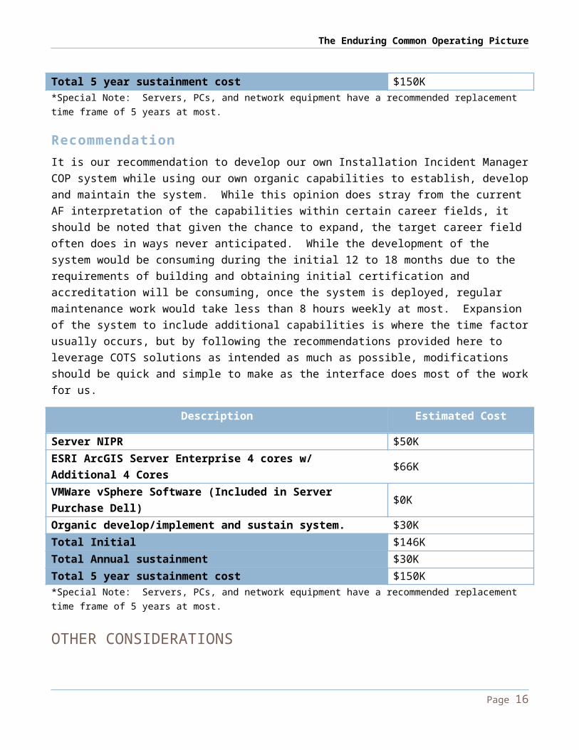
Server NIPR $50KESRI ArcGIS Server Enterprise 4 cores w/ Additional 4 Cores $66KVMWare vSphere Software (Included in Server Purchase Dell) $0KOrganic develop/implement and sustain system. $30KTotal Initial $146KTotal Annual sustainment $30KTotal 5 year sustainment cost $150K*Special Note: Servers, PCs, and network equipment have a recommended replacement time frame of 5 years at most.
Recommendation
Page 13

The Enduring Common Operating Picture
It is our recommendation to develop our own Installation Incident Manager COP system while using our own organic capabilities to establish, develop and maintain the system. While this opinion does stray from the current AF interpretation of the capabilities within certain career fields, it should be noted that given the chance to expand, the target career field often does in ways never anticipated. While the development of the system would be consuming during the initial 12 to 18 months due to the requirements of building and obtaining initial certification and accreditation will be consuming, once the system is deployed, regular maintenance work would take less than 8 hours weekly at most. Expansion of the system to include additional capabilities is where the time factor usually occurs, but by following the recommendations provided here to leverage COTS solutions as intended as much as possible, modifications should be quick and simple to make as the interface does most of the work for us.
Description Estimated Cost
Server NIPR $50KESRI ArcGIS Server Enterprise 4 cores w/ Additional 4 Cores $66KVMWare vSphere Software (Included in Server Purchase Dell) $0KOrganic develop/implement and sustain system. $30KTotal Initial $146KTotal Annual sustainment $30KTotal 5 year sustainment cost $150K*Special Note: Servers, PCs, and network equipment have a recommended replacement time frame of 5 years at most.
OTHER CONSIDERATIONSThe choice of COP is but one of many choices and considerations that need to be made during the C&A submittal process. The choice of Mission Assurance Categories is paramount as it helps ensure rapid response from the appropriate Com agencies to solve a potential outage that extends beyond our own expertise. Their expertise doesn’t include our software suites of choice, but they can help trouble shoot issues associated to authentication to the system, group policies, and network infrastructure related issues.
MAC 1 Systems handling information that is determined to be vital to the operational readiness ormission effectiveness of deployed and contingency forces in terms of both content and timeliness.The consequences of loss of integrity or availability of a MAC I system are unacceptable andcould include the immediate and sustained loss of mission effectiveness. Mission
Page 14

The Enduring Common Operating Picture
AssuranceCategory I systems require the most stringent protection measures.
MAC II
Systems handling information that is important to the support of deployed and contingency forces.The consequences of loss of integrity are unacceptable. Loss of availability is difficult to deal withand can only be tolerated for a short time. The consequences could include delay or degradationin providing important support services or commodities that may seriously impact missioneffectiveness or operational readiness. Mission Assurance Category II systems require additionalsafeguards beyond best practices to ensure assurance.
MAC III
Systems handling information that is necessary for the conduct of day-to-day business, but doesnot materially affect support to deployed or contingency forces in the short-term. Theconsequences of loss of integrity or availability can be tolerated or overcome without significantimpacts on mission effectiveness or operational readiness. The consequences could include thedelay or degradation of services or commodities enabling routine activities. Mission AssuranceCategory III systems require protective measures, techniques, or procedures generallycommensurate with commercial best practices.
Additional areas of concern would be: external data access, mobile capabilities, data standards, data and software backups, redundancy, and more.
External Data AccessAs part of our C&A submittal, we should include our intentions to open ports within the firewall to allow for our server to consume external spatial data provided by outside agencies as well as provide specific pieces of information we wish to share with them from our own systems. Typically the best method to do this would be through VPN access, however, as that is typically a token based authentication method ie. CAC card, this may prove problematic as we would want this external tap to be as automated as possible. Our server should be capable of support an additional virtualized server that can be made accessible when needed to hold only the data we would want. This server would only house the necessary data needing to be shared and would not have any other data stored within it at any point. As this server would be fully virtualized it could be moved to other servers easily or isolated from the network if compromised without damaging our ability to operate the COP at any given point.
Mobile Data Collection
Page 15
The Enduring Common Operating Picture
As we have chosen to operate a stock version of ESRI’s ArcGIS Server, there are free mobile applications written by ESRI for the iOS and Android devices that can be harnessed by our personnel and their dependents after an emergency. These mobile sensors could provide us detailed information about what is happening in a matter of minutes vs. the hours it would take for us to discover all the potential issues around base. If direct access to our servers is unwise, we can leverage free services from Google that would allow similar capabilities while we would consume the data directly from Google’s Servers. The Kansas City Fire Department experimented with a similar system to great success.
Data StandardsWhile data standards play somewhat fast and loose in the civilian community, we should maintain the same standards at all times as HQ AF/A7. This will ensure that we can continue to consistently consume data from our GeoBase personnel while at the same time, providing a template that has been accepted for use by most Federal Agencies. While it will not fix incompatibilities between us and our State counterparts, it will go a long way to ensuring a consistent standard is followed and maintained.
Data BackupsIt is not known at this time how Com currently backs up its servers within its Network Operations Center, but we need to ensure that we are backing up our data daily if not every 8 to 12 hours. In addition to backing up our data, the choice of a virtualized server enables us to take snapshots of that server and its data throughout the day. We should balance those snapshots with our performance needs vs. our level of tolerance for performance degradation during a crisis. This ensures our systems are continually backed up at a rate that is acceptable to our potential loss.Spatial data could be further backed up by our EOC and UCC representatives through desktop clients. While it is a bit cumbersome, it is something that can be made as part of their operating instructions.
RedundancyWhile the quotes above only take into consideration the purchase of a single server to handle the needs of the installation, it would be prudent to purchase 2 servers to ensure adequate redundancy exists and can continue to support the installation throughout any event. The databases between the two servers could be constantly updating ensuring that no data would be lost save for a few minutes of activities that occurred between snapshots.There are network related complications that would need to be supported by Com to ensure that when a failover event does occur, that the DNS entries to the installation shift appropriately ensuring that a mapping interface remains available at all times.
Page 16

The Enduring Common Operating Picture
The end user would only notice a momentary lack of refresh on their screen or the need to reopen their mapping interface to see the latest and greatest COP. The cost of a second server would double the projected costs on the previous page, but it provides the greatest level of security possible during an emergency.
More ConsiderationsThe formation of a working group to pull in all the requirements from CE and all other base agencies would be critical to ensuring the successful deployment of any COP solution. These agencies may have other capabilities that can be contributed to the COP such as weather data, inventories of facilities, and more that could be crucial to making fast and correct decisions by commanders using the COP. Additionally, there are more tools provided by the software manufacturer that could support the installation in terms of performing spatial analysis and/or replaying events through temporal tool sets. These tools could help predict looming disasters before they occur during an incident.
Page 17

The Enduring Common Operating Picture
DEPLOYMENT TIMELINEThe following grid is the anticipated timeline associated to deploying Installation’s Incident Manager COP. Other solutions, if chosen, would take a similar development track. Deviation occurs after fielding where customization may take longer via contracted support.
Phase Activity Start / End Time
1Development of requirements package. This includes discussion of capabilities needed to be fielded to meet installation needs.
Month 0 – Month 1.5
1 Begin development of certification & accreditation packages
Month 1 – Month 1.5
2Develop System Identification Profile to include security and controls package for Implementation Plan
Month 1.5 – Month 4
2Submit Form 9’s for servers, software, and contracted support (if required). Request 6 months to award allowing for verification in triplicate as C&A package develops.
Month 1 – Month 1
7.5 Months Elapsed3 Purchased equipment arrives Month 93 DIACAP Implementation Plan Completed Month 83 iCTO Received…begin installation Month 10 (at earliest)4 Begin DIACAP Validation Month 11 (at earliest)4 Approval to Operate Decision Month 13 (at earliest)5 COP development Month 13 – Month 18
18 Months Elapsed
If all goes according to plan, the Installation’s COP will be online NLT the middle of FY14 if we started today.
INTERFACE EXAMPLESWhile there are many different types of systems available, we have chosen to provide interface examples from a locally developed system within the Air Force that has been in operational since 2009. The system itself rides upon a COTS solution, but has been extensively expanded to be able to provide point and click functionality to its users. The system was first brought online to meet the demands of the virtual ECC environment and thus was originally designed to handle more Air Force Incident
Page 18

The Enduring Common Operating Picture
Management focused items, but quickly evolved to allow for wartime and even Public Works related capabilities to be available at a moment’s notice.The lion share of development was not done via contractor, but by a military member who learned how to manipulate the interface by reading the manuals and using the support message boards for the software developer. Once the system was brought online it required little to no weekly support unless there was a problem between Com and the server itself.Most installations who have deployed similar systems continue to use it to this day, to include Korea and Japan. While Korea continues to use UL/UC2 as its primary C2 system, it also leverages AFIM as a backup and more flexible solution when it needs to respond to incidents such as Typhoons.
Security Forces Incident C2The following screenshot is from a solution deployed at Yokota Air Base, Japan.
At present, the above interface is depicting fire at a facility. FD was able to plot a cordon around the facility which automatically generated suggested optimal traffic
Page 19

The Enduring Common Operating Picture
control points. SFS was able to establish its ECP, plot locations of its responders and view anything FD was plotting to include where its trucks would be stationed in response.
Page 20

The Enduring Common Operating Picture
Fire Department Incident C2
You are seeing a combined data view containing data from SFS and FD shared between each other. The FD is viewing the status of one of its hydrants for potential use, while simultaneously being capable of seeing where traffic control points have been established in order to relay that information to the on scene incident commander. Additionally, should the incident evolve, FD could potential review the HAZMAT contents of each facility in order to provide optimal protection to all emergency responders.
Page 21

The Enduring Common Operating Picture
ADDITIONAL AREAS OF INTERESTWhile the deployed C2 solution the installation has been UL/UC2 for quite some time, the same problems of its predecessor remain. The system does not conform to the conventions of Spatial Data Standard for Facilities Infrastructure and Environment (SDSFIE) which consistently makes UL/UC2 a laborious process to update, even more so as changes to expands to new versions. Additionally, unlike a GeoBase type system, UL/UC2 cannot consume ACES tabular data and on an autonomous basis updates its own database.
The above is a proposed method by which GeoBase autonomously update its tabular real property data during periods of lower activity. This ensures GeoBase hosted data or in this case, the COP tabular data is accurate to Real Property records every 24 hours.
Page 22

The Enduring Common Operating Picture
PROPOSED INFRASTRUCTURE LAYOUT
VMWareUsing VMWare vSphere allows us to operate multiple servers within a single box, thus reducing our infrastructure costs. Traditionally, especially with high bandwidth applications such as SharePoint and COPs, we would find them residing on separate systems in two different boxes. When one system crashes, the other would remain unaffected, however, the entire system would remain down until it could be restored. Within a VMWare environment, each server is a virtualized component and thus when it crashes; the last known good configuration could be immediately brought online with minimal disruption in services. This approach not only allows us to provide redundancy on many levels, it allows to move servers and capabilities wherever they are needed so long as you have a bootable PC.
SharePoint DashboardWith the introduction of SharePoint as the missing component of the UL/UC2 like interface, the base can host its own dashboard providing the same capabilities in an more flexible environment that can change as the situation needs. The current UL/UC2 system is inflexible as relies heavily on a custom made application code base and thus when changes are needed, the company must be contracted to do so. In our scenario, we can change the system to meet our needs any time without permission or additional contracted costs.
Page 23

The Enduring Common Operating Picture
Data RedundancyWhile the use of a SAN would be preferable in most situations to allow for optimal data redundancy, the costs of deploying a SAN are prohibitive at best. Our proposal leverages the VMWare solution to take snapshots in time of the servers when they are performing optimally. Should a crash occur, it could be easily restored as previously stated. However, we go a step further to ensure maximum redundancy. Leveraging a capability built into Oracle, our database solution of choice for storing Spatial Databases such as those needed for a COP, we choose to employ a method called Synchronous Change Data Capture which essentially means, as information changes in one database, it gets update in another. The drawback associated to this method typically is higher overhead for the server processing transactions such as adding incidents to map. However, with properly specifying the frequency that this occurs in, for example every five minutes or so, resources can be saved ensuring that optimal database efficiency is available at the right times.The deployment of two server solutions meets the MAC I systems environment, however deploying under a MAC II environment would not require the added hot standby server, but would cut our capability to provide data redundancy entirely.
SIPR DeploymentThe same system architecture described above can be deployed within the SIPR environment easily.
CONCLUSIONThe biggest issue we will run into while attempting to standup a COP for the installation will be the constantly shifting rules that govern Com. They present unexpected delays and those making decisions are not at our installation and thus cannot be counted on to make hasty decisions that may or may not work in our favor. Much of each submittal is sent back for clarification especially with GeoBase systems are they are not as straight forward the typical systems that are deployed in the Com community. However, with patience and openness to the process, it can be achieved. Thank you for your consideration of this proposal and should you have any questions, please contact us at your earliest convenience.
Page 24