the effect of acid mine water on ground water hydro … · tanah bumbu district of south kalimantan...
TRANSCRIPT

International Journal of Applied Chemistry.
ISSN 0973-1792 Volume 12, Number 3 (2016) pp. 293-308
© Research India Publications
http://www.ripublication.com
The Effect Of Acid Mine Water On Ground Water
Hydro-Chemical, In Mantewe, Tanah Bumbu
Regency, South Kalimantan, Indonesia
Hanif Faisol Nurofiq, Mohammad Bisri, Soemarno, Athaillah Mursyid, Prast
Rubiantoro, and M. Haris Miftakhul Fajar
University of Brawijaya, Malang, Indonesia.
Corresponding Author: [email protected]
Abstract
Openly coal mining can damage the layer structure so that the groundwater
aquifers that are in the aquifer layer filling out the coal mining pond. Free
oxygen available at the mine accelerate the process of formation of acid mine
water as the negative impact of mining coal. When the rainy season rain fell
increase the amount of water that is mixed with coal at the mine pond, so the
acid mine drainage can melimpas form the surface flow. The research location
is in the district. Mantewe Kab. Land of Spices. At this location there are
several coal mining sites openly. The purpose of this study was to determine
the impact of acid mine drainage on water quality in the vicinity of the study.
Test parameters on this research activity is determined only a few chemical
elements that exist in South Kalimantan Governor Decree No. 05 of 2007 on
the standard allotment and river water quality standard. Parameters-The
parameters are: DHL, TDS, pH, Fe and Mn. From the data analysis lab, coal
mining in the District Mantewe a negative impact in the form of acid mine
drainage. Acid mine water accumulating in an ex-mine coal with a
concentration parameters-the selected parameters exceed the quality standard
limits allowed. Acid mine water flowing on the surface does not pollute the
river that flows near the site of research and acid mine water that infiltrated
into the soil into groundwater will not pollute wells-wells closest to the sites.
Keywords: Coal, Acid Mine Water, DHL, TDS, pH
1. INTRODUCTION
According Murtianto [9] South Kalimantan coal is a contributor to the national second
largest after East Kalimantan. Activity coal mine in South Kalimantan, one of which
294 Hanif Faisol Nurofiq et al
is in the district. Mantewe Kabupetan Land of Spices. The high activity coal mines in
the region, causing a risk of water pollution both surface water and ground water is
getting higher. Acid mine drainage is one of the products of coal mines often become
pollutants of surface water and groundwater [2], [4]. Openly coal mining can damage
the layer structure so that the groundwater aquifers that are in the aquifer layer filling
out the coal mining pond. Free oxygen available at the mine accelerate the process of
formation of acid mine water as the negative impact of mining coal. When the rainy
season rain fell increase the amount of water that is mixed with coal at the mine pond,
so the acid mine drainage can melimpas form the surface flow.
For the prevention of adverse effects of acid mine water as a result of coal mining on
water quality, the South Kalimantan Governor issued regulations. Based on South
Kalimantan Governor Regulation No. 05 Year 2007 concerning the standard
designation and river water quality standard. Stipulate that the maximum limit values
for multiple parameters: iron (Fe) total ≤0,3 mg / L; Manganese (Mn) total ≤0,1 mg /
L; Cadmium (Cd) total ≤0,1mg / L; TDS ≤ 1000 mg / L and a pH of 6-9. Therefore,
do need to investigate groundwater contamination as a result of coal mining activities
in the district Mantewe and to determine the distribution patterns by analyzing the
chemical elements selected.
2. RESEARCH METHODS
The research location is in the Village and Village Mantewe Sukadamai Mantewe
Tanah Bumbu District of South Kalimantan (Figure 1). The point-the point of
sampling include: community wells, coal mining pits, swamps-swamps, and rivers.
Test parameters on this research activity is determined only a few chemical elements
that exist in South Kalimantan Governor Decree No. 05 of 2007 on the standard
allotment and river water quality standard. Parameters-The parameters include: DHL,
TDS, pH, Fe and Mn
Parameter-test parameters mentioned above have the ability unchanged to air and
different light-different parameters TDS, DHL and pH measurements were taken on
the spot by using a portable water quality cheking. Parameter Fe, Mn and Cd have to
do the analysis in the chemical laboratory. Direct measurement of the parameters
mentioned above using a Water Quality Multi Probe brand HORIBA, this tool has the
ability to measure or read several parameters simultaneously, while the measurement
procedure in the field using this tool as follows: (1) Calibration of Water Quality
Multi Probe with standard solution which has been prepared. (2) Wash sensor-the
sensor with distilled water until clean. (3) Dip the tool directly to the point of
measurement (water bodies) for some time before the measurement. (4) Record the
readings as a means of measuring results.
Retrieval and measurement or analysis of samples is conducted in UPT
Environmental Laboratory Regional Environmental Agency Government of Tanah
Bumbu which has been accredited by the National Accreditation Committee. The
results of the analysis in the laboratory is used as the measurement data. Based on the
results of chemical analysis, can be used to know the impact of open-pit mining on
groundwater quality in the vicinity of the study. The results of the chemical analysis,

The Effect Of Acid Mine Water On Ground Water Hydro-Chemical 295
then correlated with the analysis of geology [3], hydrogeology [5, 6, 7], surface flow
analysis and analysis of land cover. From a combination of analalisa is expected to
answer the processes occurring in acid mine water in the vicinity of the study [1, 8].
Figure 1. Map of sampling locations
3. RESULT AND DISCUSSION
3.1. Chemical Analytic
Collecting data on water chemistry research site is divided into four categories. This
division is based on the type and location of the water analyzed. The categories in the
form of water chemistry data on ex-mining ponds (void); Chemical data of water in
the marshes surrounding the mine; Chemical data of water in wells near the mine, and
chemical data of water in the river which is in the vicinity of the mine [9, 10, 11].
Sampling was first performed on the water contained in the former mine pond.
Chemical analysis of water in the former mine pond was used to determine whether
the water in the former mine pond is transformed into acid mine water or not. Data
from laboratory analysis of water in the former mine pond shown in Table 1.
296 Hanif Faisol Nurofiq et al
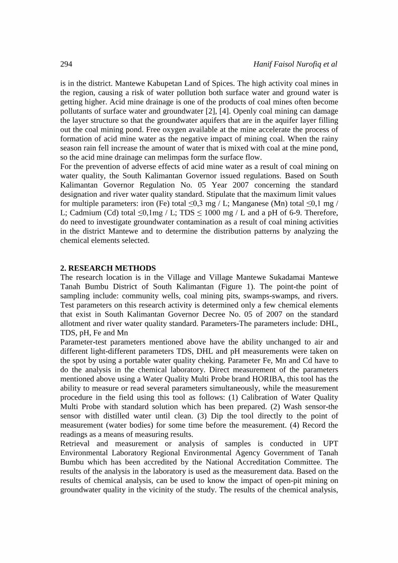
Table 1: Data quality of the water in the former coal mine
Samples Temperature (oC) pH Conductivity TDS Fe Mn
1 32.75 2.80 1243.33 795.78 3.13 6.40
2 33.50 2.94 1430.00 843.40 50.18 13.47
3 33.87 3.36 1798.75 1150.00 2.87 2.92
4 33.27 3.01 881.00 563.89 3.76 13.89
5 32.23 3.18 532.75 340.75 6.42 13.63
3.1.1. Accidity (pH)
PH or acidity indicates the concentration of hydrogen ions. If the water hydrogen ions
(H +) as positive ions only increases then the solution is acidic (water with a pH lower
7), whereas if the hydroxyl ions (OH-) as a negative ion only increases the solution is
alkaline (water larger pH 7). In general, the river water and ground water has a pH
ranging from 6 to 8.5, while the water contaminated by mining waste can cause the
water becomes acidic with a pH of less than 5. Similarly to the water that is not
contaminated, but has a low pH of less than 4 can occur because of the influence
natural environment, among others, from the oxidation of sulphide minerals (eg
pyrite, chalcopyrite), volcanic gases containing hydrogen sulfide, carbon dioxide, and
ammonia. The value of water quality standards are allowed 6-9.
Based on water quality data for the parameters pH in 5 ex-mining ponds worth 2.8 to
3.36. pH in the pond former coal mines included in the category of very sour even far
from water quality standard threshold allowed. The low pH value is a result of the
high activity of free hydrogen ions in the water pool. Hydrogen ions derived from
oxidation of pyrite (FeS2) which are contained in the coal. The opening of coal seams
by mining activities cause contact with air or oxygen and the accumulation of
rainwater and groundwater at the mine sites can accelerate the process of oxidation of
pyrite. Pyrite oxidation process as follows:
2FeS2 + 7O2 + 2H2O--> 2Fe2+ + 4SO42-+ 4H+ (1)
The first reaction of pyrite weathering merupakah reaction with the oxidation process.
Compounds of pyrite oxidized form of ferrous iron ions, sulfate ions and hydrogen
ions. 1 mole of oxidized pyrite produces 2 moles of acidity. In addition to the direct
oxidation of pyrite compounds can also be oxidized by water conditions that contain a
lot of iron (Aqueous Ferric Ion). The process of oxidation as follows:
FeS2 + 14Fe3+ + 8H2O--> 15Fe2+ + 2SO42-+ 16 H+ (2)
Oksidai pyrite by ferric iron ions ferrous iron, sulfate ions and hydrogen ions. In this
process produces more acidity. 1 and 2 of the reaction conditions of acidity increases
so that the pH of pool water more acidic former mine reaches the value <4. In this
condition, the former mining pool water is called acid mine drainage.
3.1.2. Electrical Conductivity (DHL)
The ability to conduct electricity in one cubic centimeter of water at temperatures of
25oC. Parameter DHL provides the big picture content of cations and anions in the
water. The bigger DHL, the greater the number of ions present in water and vice
The Effect Of Acid Mine Water On Ground Water Hydro-Chemical 297
versa. Mine area which contains sulfuric oxides DHLnya value reached more than
100 micromhos / cm. Based on water quality data for the parameters of electrical
conductivity shows ex-mining ponds worth 532.75 to 1798.75 micromhos / cm and
included in the high category. The high electrical conductivity values indicate the
presence of chemical processes that occur in the water ex-mining ponds and generate
a lot of free ions therein. Ions causes acidity and mineral ions coal constituent rocks
dominate as a contributor to the high value of electrical conductivity. These ions
including iron ions, the hydrogen ions and sulfate ions.
3.1.3. Total Disolved Solid (TDS)
Levels of mineral elements dissolved in water that indicate the presence of dissolved
mineral elements. Elements of dissolved minerals generally consists of carbonate,
bicarbonate, chloride, sulfate, phosphate, nitrate, magnesium, sodium, calcium,
potassium, and some other elements. Normal surface water and ground water are
generally less than 500 mg / L. The value of water quality standards are allowed ≤
1000 mg / L. Based on water quality data for total dissolved solids parameters
indicate that the former mining pool water is worth 340.75 to 1150 mg / L and in the
high category. This indicates the occurrence of contamination on the former mining
pool water, pollution is a result of the formation of acid mine water. Mineral elements
formed by the process of acid mine drainage results in a high value of total dissolved
solids. The elements which greatly contributed to the value of total dissolved solids
diataranya is the element hydrogen, sulfate and mineral elements other metals.
3.1.4. Iron (Fe)
The element iron are in most rocks on earth. In igneous rocks of elemental iron in the
form of mineral amphibol, pyroxene, magnetite, pyrite, biotite, and garnet, whereas in
sedimentary rocks in the form of iron oxides, carbonates and sulfides of clay minerals.
Iron in groundwater is generally present in the form of ferrous (Fe +) of the ferrous Fe
bicarbonate (HCO 3) 2, at the moment of contact with free oxygen from the air to
form the ferry (Fe 3+) from the ferry hydroxide. In bodies of water such as marshes
and lakes with calm water and does not flow, the iron-containing fine sediment
deposition perfect experience, resulting in iron oxidation with oxygen from the air.
The oxidation process to form hydroxide and hydrogen-free ferries that meet the
water so that the water will be acidic. The value of water quality standards are
allowed to ≤ 0.3 mg / L. Based on water quality data for iron parameters indicate that
the ex-mining ponds water worth 2.87 to 50.18 mg / L, the ex-mining ponds water
contains a lot of iron ions in it and its value exceeds water quality standards are
allowed. In the process of oxidation of pyrite (FeS2) by oxygen in the water of ex-
mining ponds produce elemental iron is very abundant, so the data analysis results in
the laboratory showed levels of iron in each pool the former colliery value is very
high and exceeds the standards of water quality standards are allowed. Chemical
processes that show the abundance of elemental iron in the water ex-mining ponds as
follows:
2FeS2 + 7O2 + 2H2O-> 2Fe2+ + 4SO42-+ 4H+ (3)
FeS2 + 14Fe3+ + 8H2O-> 15Fe2+ + 2SO42-+ 16 H+
(4)
298 Hanif Faisol Nurofiq et al
4Fe2+ + O2 + 4H+-> 4Fe3+ + 2H2O (5)
Fe2+ + 1/4O2 + 5/2H2->4Fe(OH)3 + 2H+ (6)
FeS2 + 15/4O2 + 7/2H2O->Fe(OH)3+ 2SO42-+ 4H+ (7)
3.1.5. Mangan (Mn)
The element manganese is naturally derived from weathered sedimentary or
metamorphic rocks of the mineral mica, biotite, amphibole and hornblende. In nature
the element manganese is a minor element by having a small amount, generally not
more than 0.02 mg / L. If the manganese content in water is greater than 1 mg / L, the
water has suffered material contamination by acid mine or others. The value of water
quality standards are allowed to ≤ 0.1 mg / L. Based on the results of data analysis in
the laboratory for water quality parameters show that manganese in ex-mining ponds
worth 2.92 to 13.89 mg / L. The content of manganese in the water ex-mining ponds
in the high category or exceeded water quality standard limits the exposure so that the
former mine pond water is polluted acid mine drainage material. Metal manganese
dissolved in water with a weakly acidic conditions to form manganese ion (II) and
hydrogen.
Mn + 2H+ Mn2+ + H2 (8)
In addition to manganese (II) there are several complexes containing manganese in
the +3 oxidation state, Vogel (1985). In acidic conditions which contains sulfate will
form manganese (II) sulfate and oxygen compounds are released into the air.
2Mn2O3 + 4H2SO4 4Mn2+ + O2 + 4SO42-+ 4H2O (9)
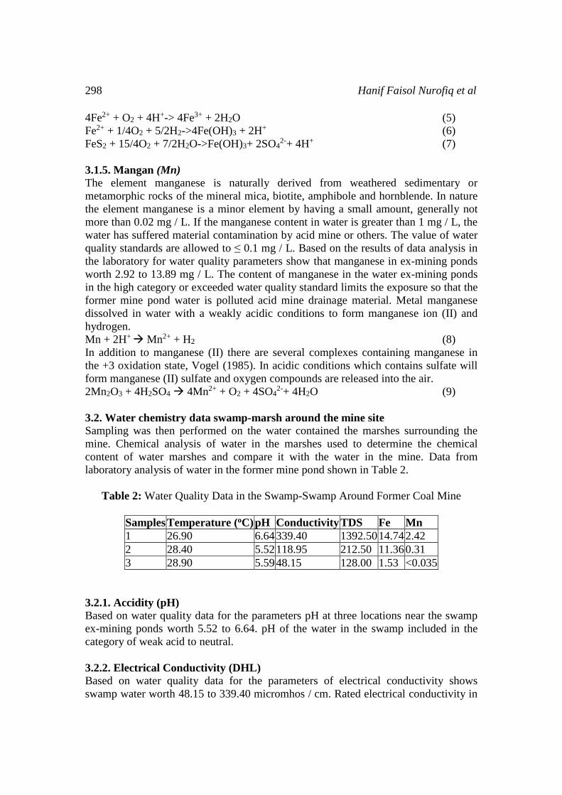
3.2. Water chemistry data swamp-marsh around the mine site
Sampling was then performed on the water contained the marshes surrounding the
mine. Chemical analysis of water in the marshes used to determine the chemical
content of water marshes and compare it with the water in the mine. Data from
laboratory analysis of water in the former mine pond shown in Table 2.
Table 2: Water Quality Data in the Swamp-Swamp Around Former Coal Mine
Samples Temperature (oC) pH Conductivity TDS Fe Mn
1 26.90 6.64 339.40 1392.50 14.74 2.42
2 28.40 5.52 118.95 212.50 11.36 0.31
3 28.90 5.59 48.15 128.00 1.53 <0.035
3.2.1. Accidity (pH)
Based on water quality data for the parameters pH at three locations near the swamp
ex-mining ponds worth 5.52 to 6.64. pH of the water in the swamp included in the
category of weak acid to neutral.
3.2.2. Electrical Conductivity (DHL)
Based on water quality data for the parameters of electrical conductivity shows
swamp water worth 48.15 to 339.40 micromhos / cm. Rated electrical conductivity in

The Effect Of Acid Mine Water On Ground Water Hydro-Chemical 299
swamp water tends to be lower than the electrical conductivity of the water ex-mining
ponds, this shows that the ion content-free ions in a water marsh greatly reduced
significantly. Free cations and anions sulphate-free hydrogen is abundant in water ex-
mining ponds, chemically bonded to the compound calcium carbonate becomes
calcium bisulfate compounds and carbonic acid compounds.
3.2.3. Total Disolved Solid (TDS)
Based on water quality data for total dissolved solids parameters indicate that the
swamp water is worth 128 to 1392.50 mg / L and in the high category, especially in
the areas of swamp 1. This shows the number of solids in the form of salt-salt
dissolved in water marsh. In addition to salt solids-salts of iron oxide from acid mine
runoff ex-mining ponds as well as salts-salt reaction process limestone with acid mine
drainage material.
3.2.4. Iron (Fe)
Based on water quality data for iron parameters indicate that the swamp water worth
1.53 to 14.74 mg / L, the swamp water still contains a lot of iron ions in it and its
value exceeds water quality standards are allowed. But the value of iron in the water
marsh is much lower than the value of iron in the water marsh. Most irons have
undergo hydrolysis to form iron hydroxide precipitate on the basis of ex-mining
ponds, while the iron is not yet perfect hydrolyzed water-borne melimpas into the
swamp water.
3.2.5. Mangan (Mn)
Based on the results of data analysis in the laboratory for water quality parameters
show that manganese in the swamp worth <0.035 to 2.42 mg / L.
3.3. Data quality of well water in the residential area around the mine
Sampling was then performed on the well water contained residents in the vicinity of
the mine, precisely the eastern part of the mining area. Chemical analysis of water in
wells is used to determine the chemical content of water wells and determine whether
the water is contaminated. Data from laboratory analysis of water in the former mine
pond shown in Table 3.
Table 3: Well Water Quality Data in Residents in Nearby Ex-Mine
Samples Temperature (oC) pH Conductivity TDS Fe Mn
1 26.42 5.33 29.00 19.00 <0.081 <0.031
2 27.88 6.74 254.40 165.40 <0.081 <0.031
3.3.1. Accidity (pH)
Based on water quality data for the parameters pH at two locations near the residents'
wells ex-mining ponds worth 5.33 to 6.74. pH of the water in the wells included in the
category of weak acid to neutral.
300 Hanif Faisol Nurofiq et al
3.3.2. Electrical Conductivity (DHL)
Based on water quality data for the parameters of electrical conductivity showed well
water is worth 29 to 254.40 micromhos / cm. The value of the electrical conductivity
of well water tends to be lower than the electrical conductivity of the water ex-mining
ponds. Ion-free ions contained in the well water is the result of condensation of
minerals-mineral rocks were passed. Ion-free ions in the wells is not associated with
the ion-ion-free acid mine of ex-mining ponds, because of differences in the
hydrogeological system and akuiklud bulkhead between the two systems.
3.3.3. Total Disolved Solid (TDS)
Based on water quality data for total dissolved solids parameters indicate that the well
water is worth 19 to 165.40 mg / L and included in the low category. It shows the
large number of solids in the form of salt-salt dissolved in water is very small wells.
Dissolved solids in the water wells are not associated with dissolved solids in the
water ex-mining ponds a much higher value.
3.3.4. Iron (Fe)
Based on water quality data for iron parameters indicate that the well water-value
<0.081 mg / L, the well water contains little iron ions inside and well below the water
quality standards are allowed. Rock minerals that are dissolved by groundwater
flowing wells contain little iron element. This is quite different from the
characteristics of the former mining pool water that contains a lot of iron, especially
coming from pyrite (FeS2). The results of well water quality data also show that there
is no excessive iron metal pollution.
3.3.5. Mangan (Mn)
Based on the results of data analysis in the laboratory for water quality parameters
show that manganese in the wells worth <0.031 mg / L. The content of manganese in
the water wells below the water quality standard limits allowed. Rock minerals that
are dissolved by groundwater that flows in wells containing manganese bit. This is
quite different from the characteristics of the former mining pool water that contains
manganese metal, either manganese (II) mapun manganese (III). The results of well
water quality data also show that there is no excessive manganese metal pollution.
3.4. River water quality data in District Mantewe
Sampling was then performed on Sungi water around the mine. Chemical analysis of
water in the river was used to determine the chemical content of the water stream and
compare it with the water in the mine. Data from laboratory analysis of water in the
former mine pond shown in Table 4.
The Effect Of Acid Mine Water On Ground Water Hydro-Chemical 301
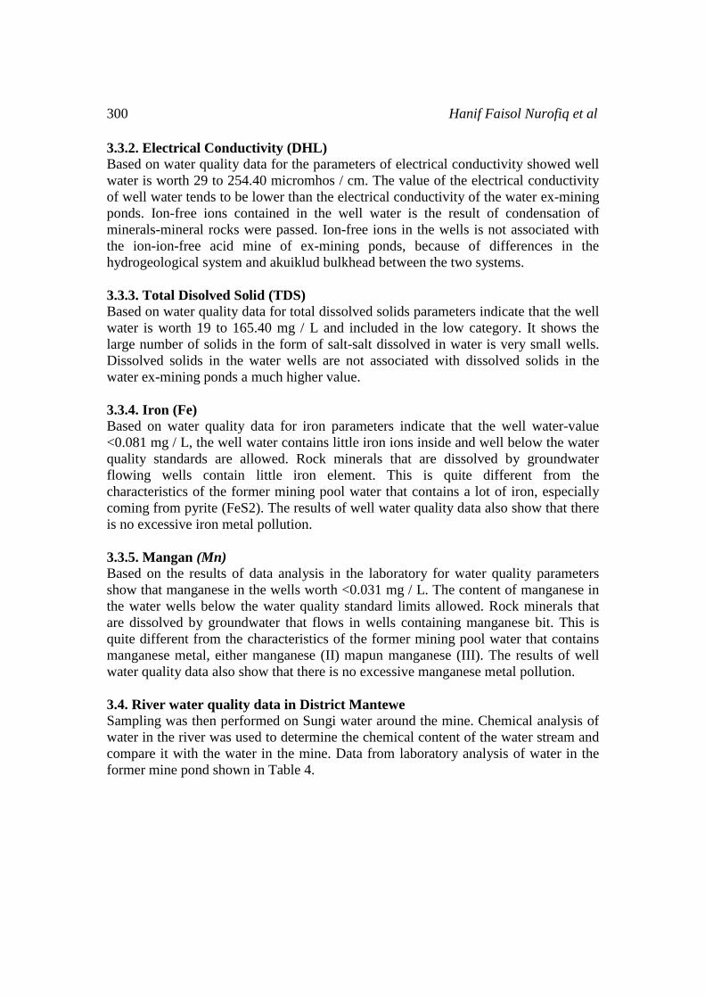
Table 4: Water Quality Data river Nearby Ex-Mine
Samples Temperature (oC) pH Conductivity TDS Fe Mn
1 30.00 6.75 242.50 162.00 0.37 0.08
2 29.00 7.19 246.60 177.00 0.64 0.09
3 30.00 7.10 246.70 178.00 0.60 0.09
4 28.00 7.21 232.90 154.00 0.49 0.09
3.4.1. Accidity (pH)
Based on water quality data for the parameters pH at 4 points of the river near the
mine site is worth 6.75 to 7.21. pH of water in the river is included in the neutral
category. Melimpas former quarry pond water to the swamp-marsh around the pond,
then if the water level in the swamp-marsh beyond surface topography melimpas no
water will pass through the channel leading to the larger stream. In the upper reaches
of the river water pH 6.75 and then the water flows toward the confluence with water
from the swamp-marsh around ex-mining ponds, water pH 7.19. An increase in the
pH value becomes more neutral, suggesting that the flow of water from the swamp-
marsh able to raise the pH of the river.
3.4.2. Electrical Conductivity (DHL)
Based on water quality data for the parameters of electrical conductivity showed the
river water is worth 232.9 to 246.70 micromhos / cm. The value of the electrical
conductivity of river water tend to be lower than the electrical conductivity of the
water ex-mining ponds, this shows that the ion content-free ions in river water is
greatly reduced significantly. In the upper reaches of the river water electrical
conductivity micromhos 242.5 / cm and then flows toward the confluence with
swamp water electrical conductivity value of the water of the river rose to 246.60
micromhos / cm. it demonstrates the ion-ion-free water of the marsh through the
channel into the river still contains ion-free ions are relatively higher than the ion-ion-
free in the river. Then the river flows to the confluence with the river passing through
neighborhoods affixes, electrical conductivity increased though not significantly be
246.70 micromhos / cm. this indicates that the river water additive containing more
ions-ions free from the river water. From the point of confluence with the river flows
into the river water recharge downstream, at this point the electrical conductivity
decreased significantly to 232.9 micromhos / cm. journey toward the downstream
river water did not experience affixes again so that the river can lower ion-ion-free
with the ability of the river to purify oneself (self purification).
3.4.3. Total Disolved Solid (TDS)
Based on water quality data for the parameters total dissolved solids showed the river
water is worth 154-178 mg / L. The value of the electrical conductivity of river water
tend to be lower than the total dissolved solids water ex-mining ponds, this shows that
the salt content-salt dissolved in the water of the river is greatly reduced significantly.
In the upper reaches of the river water total dissolved solids 162 mg / L then flows
302 Hanif Faisol Nurofiq et al
toward the confluence with swamp water total dissolved solids river water increased
to 177 mg / L. it indicates salt-water soluble salts of the marsh through the channel
towards the river is relatively higher than the river water. Then the river flows to the
confluence with the river passing through neighborhoods affixes, total dissolved
solids increased though not significantly to 178 mg / L. this indicates that the river
water additive containing more salt-salt dissolved in the river water. From the point of
confluence with the river flows into the river water recharge downstream, at this point
of total dissolved solids significantly decreased to 154 mg / L. journey toward the
downstream river water did not experience affixes again so that the river can lower
the salt-salt dissolved in the river's ability to purify oneself (self purification).
3.4.4. Iron (Fe)
Based on water quality data for iron parameters showed the river water is worth 0.37
to 0.642 mg / L. Values of elemental iron in the water of the river tend to be lower
than the water content of elemental iron in ex-mining ponds, it indicates that the iron
content in the water of the river is greatly reduced significantly. On the upstream side
of the element iron content in the water of the 0.37 mg / L then flows toward the
confluence with the value of the element iron swamp water river water rose to 0.642
mg / L. it does show still abundant element iron contained by water from the swamp-
marsh near the mine. Then the river flows to the confluence with the river passing
through neighborhoods affixes, elemental iron decreased significantly despite not
become 0,6mg / L. this indicates that the iron element content of the river water
additive does not affect the iron content of the river water, river water even affix able
to dilute the river so that the iron content which initially concentrated becomes more
dilute. From the point of confluence with the river flows into the river water recharge
downstream, at this point the element iron has decreased significantly to 0.49 mg / L.
journey toward the downstream river water did not experience affixes again so that
the river can lower iron element with the ability of the river in purifying oneself (self
purification).
3.4.5. Mangan (Mn)
Based on water quality data for the parameters manganese showed the river water is
worth 0.08 to 0.09 mg / L. The value of the element manganese in the river water tend
to be lower than the content of manganese in the water ex-mining ponds, it indicates
that the manganese content in the water of the river is greatly reduced significantly.
On the upstream side of the element manganese content in the water of the 0.08 mg /
L then flows toward the confluence with swamp water river water manganese values
increased to 0.09 mg / L. it does show is still an abundance of manganese contained in
the water of the swamp-marsh near the mine. Then the river flows to the confluence
with the river passing through neighborhoods affixes, manganese does not change the
value. this indicates that the manganese element content of the water of the additive
does not affect the manganese content of the river water. From the point of confluence
with the river flows into the river water recharge downstream, at this point the
element manganese is also unchanged. The content of manganese in the river far
below the value of water quality standards are allowed at 0.3 mg / L.
The Effect Of Acid Mine Water On Ground Water Hydro-Chemical 303
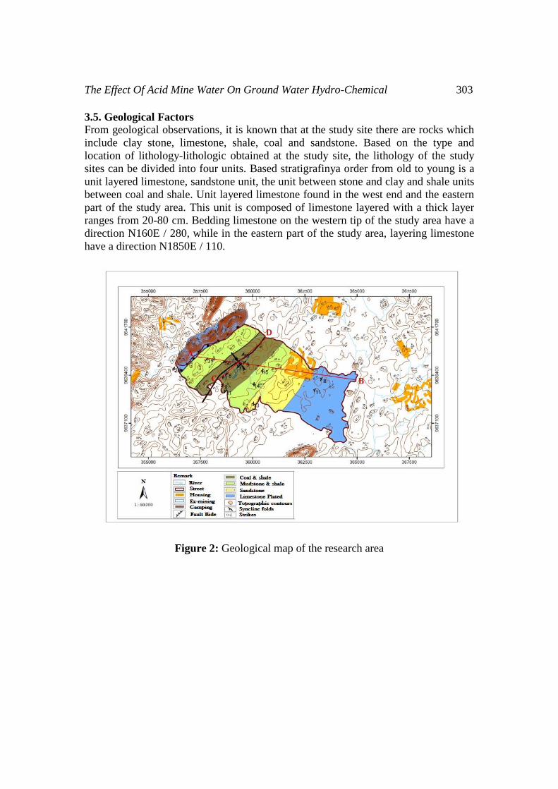
3.5. Geological Factors
From geological observations, it is known that at the study site there are rocks which
include clay stone, limestone, shale, coal and sandstone. Based on the type and
location of lithology-lithologic obtained at the study site, the lithology of the study
sites can be divided into four units. Based stratigrafinya order from old to young is a
unit layered limestone, sandstone unit, the unit between stone and clay and shale units
between coal and shale. Unit layered limestone found in the west end and the eastern
part of the study area. This unit is composed of limestone layered with a thick layer
ranges from 20-80 cm. Bedding limestone on the western tip of the study area have a
direction N160E / 280, while in the eastern part of the study area, layering limestone
have a direction N1850E / 110.
Figure 2: Geological map of the research area

304 Hanif Faisol Nurofiq et al
Figure 3: Profiles A-B and C-D of geological map of the research location
Based on the geological map (Figure 2) shows that the spreading of limestone is
located in the western and eastern parts of the study area. This spreading of limestone
in the western part of the study area to form a hill. Based on field observations of
limestone in the study site has undergone dissolution by surface water or rain water so
as to form a cavity or limestone experiencing karstification process. Dissolution that
occurs in limestone can enter to form ground water and surface water streams.
Air dissolution of limestone by rainwater run follows the contours of the surface
topography with directions to the location of a coal mine (west to east). Surface water
collected in the swamp-marsh near the mine site, containing the swamp water
dissolving limestone (CaCO3) has a relatively higher pH than the pH of the ex-mining
ponds.
pH neutral water swamp exhibits on the swamp (1 surface water) and a weak acid in
the swamp (3 surface water and surface water 4). Swamp water conductivity indicates
the number of ions-ions contained in the water, to water dissolving limestone
(CaCO3) contain many cations Ca2 + (calcium) and anion CO32-(carbonate). Total
dissolved solids (TDS) indicates the number of compounds that are dissolved in
water, the water marsh predominant compounds are compounds limestone CaCO3
dissolution results.
Acid mine drainage which contains compounds-compounds cause the degree of
acidity (pH) is low, melimpas to swamp-marsh and having direct contact with water
containing a lot of swamp white precipitate CaCO3 form the compound calcium
sulfate (CaSO4). The results of these reactions tend to produce a weak acid pH or pH
values increased significantly from the pH of acid mine drainage.
The Effect Of Acid Mine Water On Ground Water Hydro-Chemical 305
2CaCO3 + SO42-+ 2H+ Ca2SO4 + 2HCO3 (10)
Swamp-marsh located around the ex-mining ponds capable of lowering compounds-
compounds cause the degree of acidity (pH) is low so that the degree of acidity (pH)
is neutral before flowing into water bodies or river.
Surface water entering the marsh comes from rain water which passes melimpas
limestone rock formations in the western part of the location of an ex-mine. Rainwater
through the limestone rock formations capable of dissolving limestone or referred to
karstification process. Swamp water containing many compounds CaCO3 results
karstification process and then mixed with water ex-mining ponds containing acid
mine material. In the swamp water chemical reaction between calcium carbonate
compounds and sulfur compounds in acidic conditions will produce a compound
bisulfate precipitated calcium and carbonic acid. This process causes the pH of the
water in the swamp becomes more leads to even weak acids tend to be neutral. The
chemical process of lime solution reaction with acidic compounds mine as follows:
2CaCO3 + SO42-+ 2H+ Ca2SO4 + 2HCO3 (11)
The pH of the river water also showed different values. Before flowing into the river
swamp water flowing through the channel with its constituent lithologies containing
limestone, the limestone dissolution occurs along the channel leading to the river.
From the point of meeting with swamp water, river water flows into the confluence
with the river that flows past the small affixes the residence. Mangalir water in the
river comes from rain water recharge and groundwater out of the surface and has a
weakly acidic pH tends. This confluence led to a decrease in pH were not significant
from 7.19 becomes 7.10. From the point of confluence with the river water recharge
rivers flow into downstream past the limestone formations, the pH of the river water
to rise back from 7.10 becomes 7.21 because of the abundance of calcium carbonate
compound that tends to be alkaline.
3.6. Hydrogeological Factors
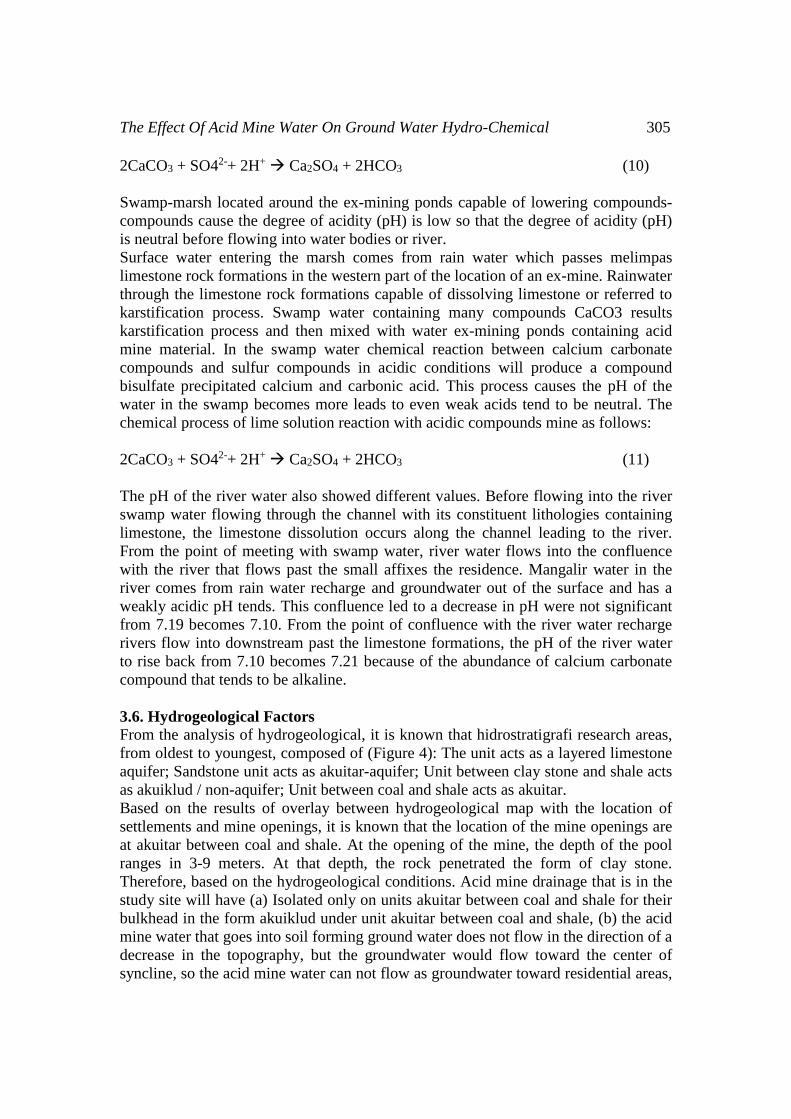
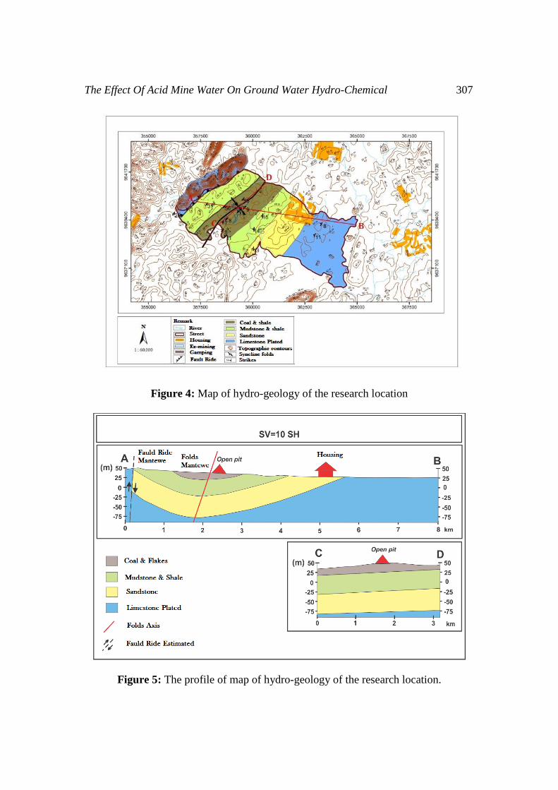
From the analysis of hydrogeological, it is known that hidrostratigrafi research areas,
from oldest to youngest, composed of (Figure 4): The unit acts as a layered limestone
aquifer; Sandstone unit acts as akuitar-aquifer; Unit between clay stone and shale acts
as akuiklud / non-aquifer; Unit between coal and shale acts as akuitar.
Based on the results of overlay between hydrogeological map with the location of
settlements and mine openings, it is known that the location of the mine openings are
at akuitar between coal and shale. At the opening of the mine, the depth of the pool
ranges in 3-9 meters. At that depth, the rock penetrated the form of clay stone.
Therefore, based on the hydrogeological conditions. Acid mine drainage that is in the
study site will have (a) Isolated only on units akuitar between coal and shale for their
bulkhead in the form akuiklud under unit akuitar between coal and shale, (b) the acid
mine water that goes into soil forming ground water does not flow in the direction of a
decrease in the topography, but the groundwater would flow toward the center of
syncline, so the acid mine water can not flow as groundwater toward residential areas,

306 Hanif Faisol Nurofiq et al
(c) Since the acid mine water that becomes ground water can not be family hot from
sayuan the then the acid mine drainage will have the potential to interact with
limestone inserts in the unit, so that the process of self-purification can take place.
Subsurface rock formations in the area of the settlement residents in the form of units
of sandstone formations that are part Warukin while the mining area in the form of
unit between coal and shale. Both of these units are separated by clay and shale rock
unit that is akuiklud. Bisri [2] akuiklud a rock layer that has a composition such that it
can accommodate the water but can not release water in an appreciable amount. This
occurs because the value of conductivity is very small, for example, a layer of silt and
mud (silt). Therefore, although it is in the region that memupunyai lower topography,
district residents' wells. Mantewe not polluted by acid mine drainage, for their
bulkhead isolating akuiklud the acidic water to remain in the unit between akuitar coal
and shale.
3.7. Land Cover Factor
At the study site plant vegetation grows in many regions around the swamp-marsh
and along the flow of surface water to the river naturally. Metal-metal that
accumulates in water and soil contaminated acid mine water into a source of nutrients
for the plants to survive. The process of phytoremediation of heavy metals by plants
takes the relatively long so that the impact of plant vegetation on the reduction of
metal on the location of the research need special assessment and its own.
The content of manganese in the water marsh in the low category to exceed the limit
of allowable water quality standard, particularly in areas of swamp 1 and 2.
Manganese reacts with warm water form a precipitate of manganese (II) hydroxide
and hydrogen
Mn + 2H2O Mn (OH)2 + H2 (12)
Deposition of manganese (II) hydroxide is rapidly oxidized when exposed to air
becomes hydrated manganese dioxide, MnO (OH) 2 precipitate brown.
Mn (OH)2 + O2 + H2O MnO(OH)2 + 2OH- (13)
The formation of sludge-sludge metal manganese in the bottom of the swamp led to a
significant reduction in the manganese content in the water marsh. In addition to the
process of phytoremediation plants manganese metal also helps in decreasing the
manganese content in the water marsh.
In addition to advanced hydrolysis process of iron in the swamp that can reduce the
amount of elemental iron in the water marsh, vegetation plants that grow around the
swamp-marsh also able to reduce the iron content in the water. the process of
absorption of heavy metals by plants in a process called phytoremediation. Firda
(2015) umbrella papyrus plants can reduce iron and manganese metal effectively with
the methods of phytoremediation in a certain time period. At the study site umbrella
papyrus plant (Cyperusalternifolius) found live and breed well.
The Effect Of Acid Mine Water On Ground Water Hydro-Chemical 307
Figure 4: Map of hydro-geology of the research location
Figure 5: The profile of map of hydro-geology of the research location.
308 Hanif Faisol Nurofiq et al
4. CONCLUSION
Based on the above, it can be concluded (1) The activity of the coal mine in the
village and the village Mantewe Sukadamai Mantewe Tanah Bumbu District of South
Kalimantan which produces the environmental impact of acid mine drainage; (2)
surface water and river water body has the ability to dilute and self purification of the
acid mine drainage so that the effects of pollution can be neutralized; (3) The ground
water or wells in the residential area not affected by acid mine water pollution due to
the influence of geological factors such as their Mantewe syncline structure and
hydrogeological factors such as their unit between akuiklud clay stone that isolating
acid mine drainage; (4) Ground water containing acid mine water in the study area to
the river (south of the former mine). Hydrogeological conditions of the study site
were able to prevent acid mine water pollution to ground water area neighborhoods;
(5) The marshes are located around the ex-mining ponds capable of lowering
compounds cause the degree of acidity (pH) is low so that the degree of acidity (pH)
is neutral before flowing into water bodies or river.
REFERENCES
[1] Asdak C., 2002, Hydrology and Watershed Management, Gadjah Mada
University Press, Yogyakarta, p 618.
[2] Bisri, M., 1991. Groundwater Flow. Malang: UPT. Penerbit Fakultas Teknik
Universitas Brawijaya.
[3] Departemen Energi & Sumber Daya Mineral, 2007, Technical Management of
Groundwater, Badan Geologi, Jakarta, p 390.
[4] Driscoll F.G., 1986, Groundwater and Wells ed. 2nd, Johnson Division, St.
Paul Minnesota, pp 10-89.
[5] Fetter C.W., 2001, Applied Hydrogeology ed. 4th, Prentice Hall, New Jersey,
p 598.
[6] Freeze R.A. & Cherry J.A., 1979, Groundwater, Prentice Hall, New Jersey, p
604.
[7] Mudiana W., 2003, Indonesian Hydro-geology Maps, Direktorat Tata
Lingkungan Geologi dan Kawasan Pertambangan, Bandung.
[8] Murtianto E., 2008, Maps of Water Basin, Pulau Kalimantan Lembar XIV,
Departemen Energi & Sumber Daya Mineral, Bandung.
[9] Suharyadi, 1984, Geohydrology, Universitas Gadjah Mada, unpublished, p
192.
[10] Todd D.K., 1980, Groundwater Hydrogeology ed. 2nd, John Willey and Sons,
New York, p 537.
[11] Danaryanto R.J., Kodoatie, Hadiparwo S. & Sangkawati S., 2008,
Management of Basin Groundwater Based Groundwater, Departemen Energi
& Sumber Daya Mineral, Jakarta, p 345.