the development of the geologic atlas of the united states
TRANSCRIPT
American Geographical Society
The Development of the Geologic Atlas of the United StatesAuthor(s): Bailey WillisSource: Journal of the American Geographical Society of New York, Vol. 27, No. 4 (1895), pp.337-351Published by: American Geographical SocietyStable URL: http://www.jstor.org/stable/197011 .
Accessed: 09/05/2014 14:05
Your use of the JSTOR archive indicates your acceptance of the Terms & Conditions of Use, available at .http://www.jstor.org/page/info/about/policies/terms.jsp
.JSTOR is a not-for-profit service that helps scholars, researchers, and students discover, use, and build upon a wide range ofcontent in a trusted digital archive. We use information technology and tools to increase productivity and facilitate new formsof scholarship. For more information about JSTOR, please contact [email protected].
.
American Geographical Society is collaborating with JSTOR to digitize, preserve and extend access to Journalof the American Geographical Society of New York.
http://www.jstor.org
This content downloaded from 194.29.185.215 on Fri, 9 May 2014 14:05:53 PMAll use subject to JSTOR Terms and Conditions

BULLETIN OF THE
AMERICAN GEOGRAPHICAL SOCIETY.
Vol. XXVII 1895. No. 4
THE DEVELOPMENT OF THE GEOLOGIC ATLAS OF THE UNITED STATES.
BY
BAILEY WILLIS.
Writing of the early work of the United States Geological Survey, the present Director recently stated: " Under the director- ship of Mr. Clarence King prominence was given to investigations of the mineral resources of the Rocky Mountain region in Colorado, Utah, and Nevada . . . . With the change of directorship in i88i and the granting of authority in I882 to complete a geological map of the United States, the policy of the Survey was modified, and its work was directed under a very comprehensive plan to the preparation of the required geological map."
At that time there was probably but one man who grasped the full meaning of the phrase " a geological map of the United States," and even under his direction it required years of experi- ment and study to establish the methods of topographic, geologic, and cartographic work which have produced the first folios of the Geologic Atlas of the United States. It is the purpose of this article briefly to trace the development of those methods, to state their present operation, and to describe the Atlas which has grown from the authority " to complete a geological map" as the oak grows from the acorn.
T17e topographic base.-European geologists have, as a rule, found military maps of large scale and detailed execution ready for their use. American geologists have, as a rule, been forced to prepare such base-maps as they could. Pennsylvania, for instance, has seen the completion of its Second Geological Survey, although there is even yet no topographic map of the State. But the policy of the United States Geological Survey since I88i has been to insist that the topographic is the indispensable base-map, and accordingly
337
This content downloaded from 194.29.185.215 on Fri, 9 May 2014 14:05:53 PMAll use subject to JSTOR Terms and Conditions

338 The Development of the Geologic Atlas of
topographic surveys have been pushed energetically for fourteen years.
On account of the immense area thus to be surveyed, requiring on the scale of 2 miles to i inch about 3,500 atlas sheets of the adopted size, the methods of survey at first selected and later elaborated aimed primarily at economy with accuracy. It has re- quired experience to prove the necessity of characteristic detail as well. The control of the topographic maps was from the beginning accurate, but the sketching which represents the environment of the mathematical points constituting the control was for a number of years broadly generalized. It has now come to be recognized that an adequate topographic map is something more than a map based on accurate control; it is one which faithfully describes the character of every feature delineated, be it stream, hill or road; it is one which is so characteristically true to the facts of drainage, relief and culture, that every cartographic detail can be identified with a natural feature, and every natural feature of sufficient mag- nitude to show on a map of that scale can be recognized. Such a map affords in every square inch numerous points for identification of positions. It is indispensable to the geologist, unless he himself shall turn topographer, but it demands for its execution the high- est skill of the topographic artist. It is small cause for wonder, then, that the efforts of the topographers were at first unequal to the task, but it is cause for congratulation that there is now a body of trained men capable of doing the highest class of topographic work.
The classification of rocks.-A geologic map is one which shows the distribution of rocks of different kinds. In the map of the United States many thousand bodies of rocks must be delineated, and a primary problem in planning the Atlas related to the classifi- cation of rocks in a manner so simple that it could be easily com- prehended and yet so elastic that it should include every possible vari ety.
Rocks are distinguished by genesis, by age, and by mineral or lithologic character. Accordingly, the classification adopted for the Atlas is primnarily genetic; it recognizes igneous rocks, sedi- mentary rocks, and surficial rocks, the last consisting of the un- consolidated materials widely distributed over the surface of the land by water, ice and wind. Metamorphic rocks are classed as altered igneous or altered sedimentary rocks if their origin be known; otherwise they are classed with the most ancient rocks as of unknown origin.
This content downloaded from 194.29.185.215 on Fri, 9 May 2014 14:05:53 PMAll use subject to JSTOR Terms and Conditions

The United States. 339
Within each genetic class rocks are grouped by age. Geologic time is somewhat arbitrarily divided into ten great periods, corre- sponding as nearly as may be to divisions generally recognized among geologists and palaeontologists. The rocks of each period may be arranged in one or more groups, according to palaeontologic distinctions.
Lastly, the units of the classification are as nearly as may be lithologically homogeneous masses, called formations. A formation is the result of essentially continuous physical conditions. Practi. cally it is the smallest homogeneous subdivision of a heterogeneous rock series which thx geologist finds it practicable to map. It is usually limited above and below by formations differing from itself according to the changes of conditions with which its development began and closed. It is recognized only so far from the type locality as it preserves its individual character, and is replaced in the cartographic scheme by another formation, or by several other formations, as the case may be, whenever the distinctive character- istics fail.
Thus a formation is defined by character, and not by the lapse of time. An example will make this clearer. The undertow retreat- ing from a wave-beaten coast sweeps back sand and silt. The sand is dropped near shore; the silt is swept further out to sea. These deposits of sand and of mud, formed simultaneously, are sand and shale when they become rock. If the land subsides the sea ad- vances, and in the course of ages the coarse deposits of sand are spread over a wide area. The corresponding fine deposits of mud are laid down over the sands, always a little behind the advancing sea-front; and when these are brought to view in land-uplifts we distinguish the sandstone and the shale as different formations. Each represents the duration of a physical condition (in this case proximity or remoteness of shore), but the epoch of sandstone making is not distinct from the epoch of shale-making. So great is the variety of littoral conditions that there may be areas where no sand was deposited, and then the shale alone is present; and others where no mud was spread, and then the rock is all sand. stone. Nevertheless, the lithologic character of either shale or sandstone being continuous, the formation remains as a unit (an elastic unit) of classification.
The limitation of a formation to the area within which it re- tains its physical characteristics is. a contradiction of the once pre- vailing assumption that the rocks of the earth's crust are disposed like the layers of an onion, and is a recognition of the fact that
This content downloaded from 194.29.185.215 on Fri, 9 May 2014 14:05:53 PMAll use subject to JSTOR Terms and Conditions

340 The Development of the Geologic Atlas of
formations are intimately imbricated. They lie one overlapping upon another, merging gradually into a third, or splitting into thin layers which are interbedded with parts of a fourth. Irregu- larity and change, not regularity and constancy, characterize for- mations.
The field work.-The threefold classification, by genesis, by age, and by lithologic character, was made the basis of an elaborate scheme for representing on maps the origins, the geologic dates, and the relations of rock formations. But before the color scheme and its application are described some reference should be made to the geologic field work.
When the topographic map of any region has been prepared with accuracy and with adequate detail, the first step toward geologic work has been taken. The geologist ceases to be an explorer; he floats down no unknown canyon toward possible cata- racts; but, equipped. with the map, he plans his campaign to the best advantage and accomplishes his work with economy of time, effort and expense.
He first seeks to classify the various rocks of the district. He would ascertain the origin of each variety. Is the rock igneous? If so, was it of volcanic eruption, or was it intruded at a depth beneath the surface? Of what period was the eruption or intru- sion? How is it related mineralogically to other igneous rocks? How is it related to the deposition of precious metals? Is the rock sedimentary? What, in that case, is its lithologic character? Was it deposited in lake, estuary, or sea? In what direction, and how far distant, was the land from which the sediments came? What was the physiographic aspect of the land, and what events of uplift or submergence introduced and limited the physical condi- tions determining the genesis of the bed, whether sandstone, shale or limestone? What life did the waters support, and to what period of the earth's history does the rock belong? What deposits of coal, iron, or other valuable minerals, are there in the rock, and how are they related to other rocks of the district? These and many other difficult questions tax the patience, observation, and trained imagination of the geologist as he traces the formations- many, it may be-occurring in a district.
The ease or difficulty of such an examination varies greatly with the nature of the country explored and the complexity of the geologic problems encountered. In the Appalachian ranges of Pennsylvania, Virginia, and Tennessee, the easily recognized sedi- mentary rocks occur in tilted layers which coincide with ridges
This content downloaded from 194.29.185.215 on Fri, 9 May 2014 14:05:53 PMAll use subject to JSTOR Terms and Conditions

The United States. 341
and valleys. The characters of the rocks and their relation to one another are evident to any close observer, but the problems of geographic changes in the remote past which they record are of profound interest and difficulty.
In the bare, precipitous peaks of Colorado and Utah each rock- mass stands out clearly as a part of the denuded skeleton of the earth. Geologic investigations received a great impetus from the ideas gathered by the early workers in this fruitful field. But the history there recorded covers so large a part of the earth's develop- ment, the mingling of water deposits with the results of volcanic activity is so general and so complex, the growth and wasting of mountain ranges has so repeatedly taken place in that western region, that many years of patient work lie before the geologists who labor there.
In the northern portion of our country and in Canada some of the oldest known rocks extend beneath the general covering of glacial deposits upon which grows the dense forest. The visible occurrences of the rocks are limited and scattered, while their nature is greatly modified by changes through which they have passed. Here, more than anywhere else, geology requires the services of the most patient, painstaking seeker after truth.
These instances may suffice to suggest the nature of the inves- tigations upon which the Geologic Atlas is based. It is founded on original work of the highest scientific accuracy.
The manuscript for the folios of the Geologic Atlas is begun in the camps which the Survey establishes each season in all parts of the country, the first draft of the map being generally prepared in the field; the final drafts for the engraver's use are made by the geologist after months of office study, or in case he has not the requisite skill, by an expert draughtsman and are submitted for editorial examination and criticism.
The color scheme; Areal Geology.-It is the function of the editor to find modes of expressing, according to a consistent scheme of representation, the diverse facts of many districts and the views of many geologists. He is governed by regulations which constitute the " color-scheme," but he has constantly to remember that clear- ness and precision of statement are more important than any rules. If in any given area which had been mapped there occurred a broad expanse of gravel, and adjacent to it a stretch of thinly bedded limestone, the representation of these areas by different colors or by different devices would constitute a geological map, printed accord- ing to its individual scheme. Assuming that for reasons of economy
This content downloaded from 194.29.185.215 on Fri, 9 May 2014 14:05:53 PMAll use subject to JSTOR Terms and Conditions

342 The Develolment of the Geologic Atlas of
but one color could be used, the suggestion lies close at hand, that the rounded gravel should be represented by dots and the bedded limestone by parallel lines, printed, let us say, in ashes-of-roses over the respective areas. Assuming that from some neighboring Vesuvius a lava-stream has flowed across the district; we may re- member that rocks which cool from a molten condition readily break into triangular or rhomboidal pieces. Accordingly, a pattern formed of two or three sets of lines crossing in such manner as to form triangles or rhombs will serve to delineate the extent of the lava. It may well happen that in the same region there is an ex- panse of ancient gneiss, a rock marked by strongly crystalline tex- ture. Seeking a means of expressing this character, we may find it in a uniform tint of color broken by short white dashes placed irreg- ularly to simulate crystals. Thus, then, we shall have distinguished the gravel, a surficial rock, the limestone, a sedimentary rock, the lava, an igneous rock, and the gneiss, a metamorphic rock, by pat- terns of dots, of parallel lines, of triangles, and of dashes, all in ashes-of-rose color. The use of these suggestive patterns to repre- sent respectively these four great classes of rocks is the funda- mental principle of the Survey's color-scheme.
But ashes-of-roses is a delicate tint, and the pattern distinctions in that color would be rather indistinct for a useful map. Color strength and color variety are needed.
The word "color " covers a multitude of effects. To avoid am- biguity I shall use hue for that quality of color by which, for in- stance, blue is distinguished from green; tint for the result of adding -white light, pink being a tint of crimson; and shade for the mixture of a hue or tint with,black. Hues, tints and shades, merging from tone to tone of the chromatic scale,-all are colors.
It has long been the practice of makers of geologic maps to use certain colors for certain classes of rocks. For example, igneous rocks are commonly mapped in tones of red, suggesting the ruddy glow which they may once have given forth; but reds also suggest iron ores. Some geologists see sandstone in every spot of yellow on the map; others assume that yellows are used only to represent the more recent formations. Blue is intimately connected with limestone, and gray with coal. But these associations are personal and often contradictory; and even were they generally observed their adoption in any systematic scheme would present almost in- superable difficulties. In the Survey scheme the four genetic rock- classes are distinguished by patterns, in the manner already ex- plained, and therefore the use of colors is freed from the limitations
This content downloaded from 194.29.185.215 on Fri, 9 May 2014 14:05:53 PMAll use subject to JSTOR Terms and Conditions
7The United States. 343
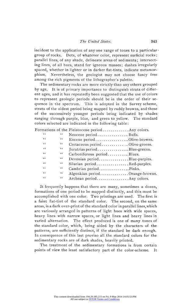
incident to the application of any one range of tones to a particular group of rocks. Dots, of whatever color, represent surficial rocks; parallel lines, of any shade, delineate areas of sediments; intersect- ing lines, of all hues, stand for igneous masses; dashes irregularly spaced, whether in lighter or in darker flat-tints, indicate metamor- phism. Nevertheless, the geologist may not choose fancy free among the rich pigments of the lithographer's palette.
The sedimentary rocks are more strictly than any others grouped by age. It is of primary importance to distinguish strata of differ- ent ages, and it has repeatedly been suggested that the use of colors to represent geologic periods should be in the order of their se- quence in the spectrum. This is adopted in the Survey scheme, strata of the oldest period being mapped by ruddy browns, and those of the successively younger periods being indicated by shades ranging through purple, blue, and green to yellow. The standard colors selected are indicated in the following table:
Formations of the Pleistocene period . .......... Any colors. Neocene period .Buffs. Eocene period .Olive-browns. Cretaceous period. Olive-greens. Juratrias period .Blue-greens. Carboniferous period .Blues. Devonian period .Blue-purples. Silurian period .Red-purples. Cambrian period .Pinks. Algonkian period .Orange-browns. Archean period .Any colors.
It frequently happens that there are many, sometimes a dozen, formations of one period to be mapped distinctly, and this must be accomplished with one color. Two printings are used. The first is a faint flat-tint of the standard color. The second, on the same areas, is a dark over-print of the standard color in parallel lines, which are variously arranged in patterns of light hues with wide spaces, heavy lines with narrow spaces, or light lines and heavy lines in varied alternation. The effect produced is one of many tones of the standard color, which, being aided by the characters of the patterns, are sufficiently distinct, if the standard be dark enough. In consequence of this last proviso all the standard colors for the sedimentary rocks are of dark shades, heavily printed.
The treatment of the sedimentary formations is from certain points of view the least satisfactory part of the color-scheme. It
This content downloaded from 194.29.185.215 on Fri, 9 May 2014 14:05:53 PMAll use subject to JSTOR Terms and Conditions

344 The Development of the Geologic Atlas of
limits the artistic possibilities and it makes difficulties in bringing out those formations which for various geologic reasons it is often desirable to emphasize. But the method possesses two very great advantages: By the use of one standard color for each period all the formations of any one period are grouped and the broad facts of distribution become strikingly conspicuous; and the employment of the same color in many maps to mean the same period of the earth's history, associates the color and the period so that the one Suggests the other, just as a Continental uniform recalls the Revolu- tionary war.
Of igneous rocks, only a few marked types are distinguishable by the naked eye, but the varieties recognized by the microscope are very numerous, and new ones are constantly appearing. With all colors available for their representation, there has as yet been no attempt at a systematic scheme, and the colorist is free to choose according to the conditions of color-association in any par- ticular map. The use of brilliant hues for igneous rocks is a natu- ral result of the employment of shades for sedimentary strata, and reds are generally preferred, but there are many exceptions.
In the northwestern region of the United States there are thou- sands of square miles of lava, called basalt, for which orange is a preferred hue. But one shrinks fronm causing the Geologic Atlas to burst into flame. A delicate shade of warm dove color serves better as a setting for smaller expanses of other colors, as may be seen in the Lassen Peak folio.
In maps of the Gold Belt of California a standard shade of blue indicates large areas of sedimentary rocks of Carboniferous age; it cries out against a bright red for the lava-flows which buried and preserved the stores of gold in the ancient gravels, and these igneous rocks are accordingly printed in a subdued shade of pink. For further contrast, other igneous rocks are represented in these sheets by tints of golden-brown.
In the Livingston (Montana) folio the shades of standard red, blue, and green required to delineate strata of certain periods pro- duced a map of sombre tone, which was lightened by introducing tints of violet and yellow for the igneous rocks. Examples might be multiplied to show the advantage of freedom in coloring the distribution of this great class of rocks, but the object is merely to indicate the principles which govern the application of the color- scheme.
The surficial deposits and the metamorphic rocks of unknown origin have not yet been mapped in sufficient variety to call for any
This content downloaded from 194.29.185.215 on Fri, 9 May 2014 14:05:53 PMAll use subject to JSTOR Terms and Conditions

The United States. 345
special consideration. For the former a color-scheme is demanded by the students of the Glacial epoch and its records. It will be long before our knowledge of the latter taxes the possibilities of the art of map-making.
I venture. to outline certain reasonings, in no wise new, which may appropriately govern color associations-at least in maps where distinctness is essential.
Of the three primary colors, red, yellow, and blue, each is the complement of the mixture of the other two, and the strongest possible color contrasts exist between the primaries and their complements. Thus:
Red contrasts with green. Yellow contrasts with purple. Blue contrasts with orange. In this statement it is assumed that the green is composed of
equivalent proportions of yellow and blue hues of equal intensity. It is obvious, then, that if the green should be more strongly tinged with blue its proper contrast would be the red correspond- ingly tinged with yellow; or if the green be of a yellowish hue, the red should have an equivalent admixture of blue. Therefore, as we pass from blue to green, the complementary hue tones from orange to red; grading from green to yellow, the opposite effects range from red to purple; whereas between yellow and orange the con- trasts vary from purple to blue. These contrasts of primary and secondary colors are extremely effective, and may be avoided or selected as the occasion demands.
The same idea may be carried a step farther with less gaudy effects if we assume a standard green, a purple, and an orange, and oppose each of them to a neutral mixture of the other two. Thus:
Green contrasts with russet or ruddy-brown. Purple contrasts with citrine or golden-brown. Orange contrasts with olive or greenish-brown. It is convenient to define russet a!s any combination of purple
and orange; citrine, as any mixture of orange and cream, and olive, as any mingling of green and purple. To obtain a standard series, scales of russets, citrines, and olives were prepared as fol- lows:
Standards of green, purple, and orange were obtained with ultra- marine blue, cadmium yellow, and madder lake, and these were mixed in pairs in carefully measured volumes. The mixtures varied: in russets, from 5 of orange and i of purple by additions of i vol- ume of purple to 5 of orange and 5 of purple, and then by subtrac-
This content downloaded from 194.29.185.215 on Fri, 9 May 2014 14:05:53 PMAll use subject to JSTOR Terms and Conditions

346 The Development of the Geologic Atlas of
tions of i volume of orange down to i of orange and 5 of purple; citrines and olives being similarly mixed, there resulted a range of hues which is definitely graded and affords the most pleasing color associations available for the maps.
Reference has been made only to the contrasts of brilliant hues, but luminosity is a quality of hues and tints in which they differ among themselves and which distinguishes them strikingly from shades, and these effects also enter into the consideration of color- schemes. In this paper, however, the subject of chiaroscuro must be dismissed without discussion.
Economic geology.-The areal geologic maps resulting from this color-scheme are of dark, strongly marked tones. rhey are open to the objection that geologic facts obscure those of topography, and to the more serious criticism that the mineral resources of any district are not particularly emphasized. The needs of the scien- tist and teacher are, however, served by such a map, which presents clearly the facts of geologic history, and any attempt to modify the representation in order to fit it to the wants of the mining engineer lessens its usefulness for this important purpose. But the processes of lithographic printing permit, without serious expense, the repro- duction of the patterns employed in the areal map, in weaker tints. Accordingly, for all districts where the mineral resources justify the duplication, the areal map is printed in fac-simile, but in faint tints, and upon this base are distributed stronger colors, which rep- resent the limited areas of productive formations. This may be better understood through an example.
In the Appalachian coal field the strata of the Carboniferous period are sandstones and shales, some of which contain valuable coal beds, while many others do not. These strata constitute for- mations, which are mapped on the areal geologic map in patterns of dark blue which distinguish the areas of each one from those adja- cent to it, but which do not especially mark those that bear coal from those that do not. In the faintly colored fac-simile of the areal map all these patterns are reproduced, their differences being ap- parent on close examination; but the extent of the valuable coal- bearing formations is strongly brought out by additional flat-tints of one or more obvious shades.
In publishing such an economic map there is risk that its mean- ing will be misunderstood. It is necessary to point out the dis- tinction between formations that contain useful minerals and those which, containing useful minerals, can be worked profitably. The former can be determined by observation, and the fact remains con-
This content downloaded from 194.29.185.215 on Fri, 9 May 2014 14:05:53 PMAll use subject to JSTOR Terms and Conditions

The United States. 347
stant; the latter can be ascertained only after consideration of com- mercial conditions, which fluctuate, and influence the conclusion accordingly. The maps issued by the Geological Survey indicate the constant facts of mineral occurrence only; the variable facts of value lie in the province of the mining engineer.
Structure sections.-A geologic structure section is a drawing which shows the profile of the surface cut by a vertical plane and the relations of rocks traversed by that plane below the surface.
In some areas the formations which are delineated upon the areal and economic geologic maps extend over the surface and are underlain flatly by other strata; elsewhere the formations dip beneath the surface. Stratified deposits in any one locality usually hold a somewhat constant relation, each one to its associated strata. Upon the basis of this relation, if the occurrence of any stratum at a definite point on the surface is known, the relative position of any other stratum beneath the surface may be inferred. This is true whether they lie in horizontal or tilted positions. The approximation of these inferences to facts varies greatly; in simple cases their exactitude has often been proved by the sinking of shafts; in more complex structure unexpected disturbances are often exposed by mining, and the inferences drawn from surface appearances are shown to be erroneous. In igneous and meta- morphic formations guesses at underground relations are purely hypothetical. Nevertheless, in the numerous cases where structure sections may be constructed with confidence, their value is mani- fold. In regions where strata carry coal, iron, oil, natural gas, or water under artesian conditions, a knowledge of the depth at which the valuable material may occur is of prime importance to development. And even elsewhere, in districts which yield no valuable mineral, inferences as to the structure of the earth's crust are of the highest scientific interest.
Accordingly, in the Geologic Atlas a sheet is arranged to delineate the distribution of formations underground as well as on the surface. It is called the structure sheet. Like the other geologic maps, it is based on the topographic map, but in the inter- est of clearness contours are omitted, and the representation of areal geology is generalized. Across this simplified geologic map one or more sections are printed, each one immediately next the line which indicates its geographic position. The space required for each section (a strip usually about an inch wide and a number of inches long) is obtained by omitting so much of the map. Thus in one view the structure sheet exhibits in horizontal plan or map
This content downloaded from 194.29.185.215 on Fri, 9 May 2014 14:05:53 PMAll use subject to JSTOR Terms and Conditions

348 The Development of the Geologic Atlas of
the surface distribution, and in vertical section the underground distribution, of formations.
Descriptzions.-The verbal descriptions in the Geologic Atlas are under three heads: there is a general explanation of the plan and subject matter of the Atlas; there is a geographic and geologic description of the region portrayed in the maps of each particular folio; and on the margin of each map is an explanatory legend, stating the meaning of the various conventions printed on the sheet.
The necessity for these elements of the Atlas arises on the one hand from the complexity of the subject treated, in a work at once so broad and so detailed, and on the other hand from the fact that few Americans are familiar with good maps. Railroad maps, State maps of small scale, county maps of large scale but no detail, and the maps of foreign atlases are the sources of geographic knowledge. A map which delineates not only every road and house, but also the form and elevation of the surface, is valued when understood, but is not understood until explained.
A feature of the exhibit made by the Survey at the Cotton States Exposition at Atlanta is a lithographic press, printing the Atlanta atlas sheet for free distribution; but the topographic map of this historic region where Sherman marched was but a maze of brown, blue, and black lines to the general public, who left it in constantly growing piles. In course of time an extended explana- tion of the work of the Survey and of the nature of the map was added on the back of these sheets, and finding in the verbal state- ment matters they could understand, the visitors carry away the maps by hundreds.
The general explanation of the scope and subject matter of the Atlas, that which is printed on the inside of the cover, was more critically prepared than any other part of the folios. At least twenty-five of the leading geologists in the United States coiitrib- uted to the discussion of the first draft, and their suggestions were embodied in a copy which was repeatedly revised by Major Powell personally, or under his direction. The resulting explanation ap- pears in the first twenty folios officially signed by him as Director.
The publication of this fundamental though elementary state- ment led to still further discussion, in consequence of which Mr. Walcott caused a rearrangement of the material and also a change in rock classification. In the former scheme, metamorphic rocks, even of known origin, were set apart as a separate class. In the now adopted classification sedimentary-metamorphic and igneous-
This content downloaded from 194.29.185.215 on Fri, 9 May 2014 14:05:53 PMAll use subject to JSTOR Terms and Conditions

The United States. 349
metamorphic rocks are placed under the heads of sedimentary and igneous, respectively. There will long remain, more particularly among the more ancient formations, metamorphic rocks whose origin is not determined; these are grouped as Archean and unclassified crystallines.
In the prolonged discussion and repeated modification of this statement of geologic A, B, C's the condition of the science is illustrated. Through independent investigations, through official surveys, and particularly through the training and labors of many students in the great universities, geology is growing so fast that the text-book is superseded before it is off the press, and the ex- plorers of to-day can only point the way for the advance to-morrow. Little geologic work is final yet. The Geologic Atlas is no excep- tion, but, if kept abreast of knowledge up to the time of publica- tion of each folio, it will contribute greatly to the progress of the science.
The special descriptions contained in any folio may relate to the province in which the district lies and to the particular district, or only to the latter. The manner of treatment has varied with authors and regions, there being no fixed rules to govern the analysis and arrangement of the geologic facts. In some cases the geologist in charge sums up the general history of the province and his assist- ants write separately of the details; in other cases the general history is incorporated in the account of local phenomena. But with this desirable freedom of treatment there is a rigid require- ment as to style: the descriptions shall be so written that any in- telligent person, though not conversant with geology, may follow their meaning. If in the interest of scientific precision technical terms become necessary, there shall in the interest of popular readers be an adequate explanation of them. The aim is to fit the folios for use as educational instruments, rather than primarily as scientific contributions. While no less truly scientific, they shall be practically useful. Huxley, who assumed as his life work the task of rendering science in popular terms, set a standard and left an ideal to be striven after.
The legend on the margin of a map is a classified list of the facts delineated therein and of their representative symbols.
It has been aptly said that a museum should be a collection of labels illustrated by specimens. This may be paralleled with much truth by saying that an atlas should be a series of legends illustrated by maps. According to the former statement, a curator knowing his particular subject should compile a consecutive series of labels
This content downloaded from 194.29.185.215 on Fri, 9 May 2014 14:05:53 PMAll use subject to JSTOR Terms and Conditions

350 The Development of the Geologic Atlas of
and then seek specimens to put with them; and according to the parallel, the geologist should first classify and summarize his facts in a legend before proceeding to express them on a map. Mentally this is the procedure, but the reduction of the mental legend to visible form is usually carelessly done. It is as though an author wrote in Russian, and handed a reader ignorant of that language a fragmentary dictionary. In the Geologic Atlas much attention is given to the preparation of the legends, with a view to classify cor- rectly and to summarize adequately the essential features of the topography and geology in each area.
The technicalprocesses. -The Geologic Atlas in its present form is the result of copper engraving and lithographic printing in a divis- ion of the Survey established for the purpose. The technical execution is the very best, and has been made possible only by complete control of the processes through a chief engraver, whose interest prompts his ingenuity, which has never yet failed in adapt- ing methods to the demands of geologic representation. Under the contract system elsewhere prevailing in Government work, the elaborate experiments, the frequent revision of proofs, and the uniformly high standard of published maps would be impossible, while the cost would exceed that at which the folios are now pro- duced.
The basis of the work is the topographic map, for which three copper plates are engraved. On one plate are cut all the data to be printed in black on the map; another receives all the lines to be indicated in blue; and a third, all the lines appearing in brown. To print the topographic maps an impression is transferred from each of these plates to a separate lithographic stone, which is placed in the press and inked with the appropriate color. Every sheet of paper is then run over the three stones, receiving three distinct impressions, which constitute it a map. In all such print- ing it is essential that each impression should fit exactly with all other impressions.
The geologic data are likewise engraved on copper and trans- ferred to lithographic stone; the elaborate patterns are transferred fromi copper plates or from stone to other stones, with great pre- cision, and the fourth or fifth proof sent to the editor is a map printed in all the selected colors from as many stones. There may be only a few colors; there may be twenty or thirty. Each one requires a separate printing, and each printing must exactly fit all the others. To pass a large sheet of paper twenty times through the press and each time to place it within a hundredth of an inch of its
This content downloaded from 194.29.185.215 on Fri, 9 May 2014 14:05:53 PMAll use subject to JSTOR Terms and Conditions

The United S/a/es. 351
previous position is difficult, and in handling 4,000 to 5,000 copies a day the most expert feeder occasionally fails. But in the matter of register (as this fitting is called), and in cleanness, sharpness, and precision of execution, the maps of the Geologic Atlas of the United States challenge comparison with any other work in this country or in Europe.
This content downloaded from 194.29.185.215 on Fri, 9 May 2014 14:05:53 PMAll use subject to JSTOR Terms and Conditions