the desert sagedesertpeaks.org/newsletterbackissues/2015/sage357.pdf · the desert sage 4 may-june...
TRANSCRIPT

The Desert Sage ISSUE NO. 357
OUR 74th SEASON
MAY-JUNE 2015
http://angeles.sierraclub.org/dps/

The Desert Sage 2 May-June 2015
Among recent finds
on what a friend, a
mountains runner
as I am, refers to as
“the interweb” is a
website for Desert
Magazine (www.swdeserts.com). Many may
remember Desert Magazine, started by Randall
Henderson and published from 1937 to 1985. I
read many issues of it and was always fascinated
by it, learning more as my brother introduced
me to the California desert by taking me out past
Baker looking for geodes - some of which I still
have. The website has an archive of all of the
magazines and advertises that they will send two
CDs with the complete set of magazines for
$10.00. Ask me next month if it works - I sent
for them the other day.
I rediscovered the magazine when I read
recently that Ulysses S. Grant IV (yes, that
Grant) had been chair of the UCLA Geology
Department and remained there as a professor
until he retired in 1959. I was surprised as I had
attended UCLA in the 1950s and had some
contact with the Geology department, so - of
course - Wikipedia provided more information.
Grant passed away in 1977, but among the
references in Wikipedia was an article he wrote,
published in Desert Magazine in March of 1962,
entitled “A Midsummer Motoring Trip”. The
trip was made with his brother in June 1913,
through Banning, Palm Springs and Coachella,
in an Overland coupe. It is a breezy but
interesting account including the (undoubtedly
overloaded) Overland having broken down west
of the Salton Sea, forcing the brothers to walk
quite a few miles for help. It is interesting to
read about this “overland” trip, as it were, on
dirt roads that now are highways.
Among other things in the news these days is
water, of course. I don't know how many saw
the front page article in the Los Angeles Times
on April 2, 2015 with a photograph of Governor
Brown and Frank Gehrke of the state
Department of Water Resources walking across
a meadow near Echo Summit, in the Sierra. The
meadow should have several feet of snow but
does not; it looks like a summer day there. The
snowpack is 5% of average according to the
article.
I love the desert, and it's a good thing, because
we live in one. We should begin behaving like
we live in a desert instead of lavishing water on
non-native plants - and on golf courses in the
Coachella Valley. Though California agriculture
accounts for about 75% of the state's water
usage, Governor Brown put it well when he said
in his statement: “We all have something to do,
and we all can do a little better”.
Chair’s
Corner
by
Paul Cooley
THE NEXT SAGE SUBMISSION DEADLINE
IS JUNE 14, 2015
The Desert Sage is published six times a year by the Desert Peaks Section of the Angeles Chapter of the Sierra Club. Subscription to The Desert Sage is ten (10) dollars a year. See back cover for ordering details. The Desert Peaks Section’s Sage is the property of the Desert Peaks Section of the Angeles Chapter of the Sierra Club. All rights reserved.
The Desert Peaks Section maintains a website at:http://angeles.sierraclub.org/dps/

The Desert Sage 3 May-June 2015
Chair Paul Cooley
4061 Van Buren Place Culver City, CA 90232
(310) 837-4022 [email protected]
Vice Chair / Outings / Safety
Brian Smith 2306 Walnut Avenue
Venice, CA 90291 (818) 898-2844
Secretary Jim Fleming
538 Yarrow Drive Simi Valley, CA 93065-7352
(805) 405-1726 [email protected]
Program / Banquet
Gloria Miladin 11946 Downey Avenue
Downey, CA 90242 (562) 879-5426
Treasurer Pat Arredondo
13409 Stanbridge Ave Bellflower, CA 90706-2341
(562) 867-6894 [email protected]
Archives Barbara Reber PO Box 1911
Newport Beach, CA 92659-0911 (949) 640-7821
Conservation Chair Dave Perkins
1664 Buttercup Road Encinitas, CA 92024-2451
(818) 366-7578 [email protected]
Guidebook Editor Jim Morehouse
3272 River Glorious Lane Las Vegas, NV 89135-2123
(702) 528-3712 [email protected]
Mailer Elaine Baldwin
3760 Ruthbar Drive Hawthorne, CA 90250-8473
(310) 675-4120 [email protected]
Membership Records Chair Ron Bartell
1556 21st Street Manhattan Beach, CA 90266
(310) 546-1977 [email protected]
Merchandising Gloria Miladin
11946 Downey Avenue Downey, CA 90242
(562) 879-5426 [email protected]
Mountain Records (Registers) Daryn Dodge 2618 Kline Ct
Davis, CA 95618-7668 (530) 753-1095
Mountaineering Committee Chair
Brian Smith 2306 Walnut Avenue
Venice, CA 90291 (818) 898-2844
Mountaineering Committee Ron Bartell
[email protected] Tina Bowman
Newsletter Editor (SAGE) Greg Gerlach
23933 Via Astuto Murrieta, CA 92562
(626) 484-2897 [email protected]
Webmaster Kathy Rich
2043 Berkshire Avenue South Pasadena, CA 91030 [email protected]
Elected Positions Appointed Positions
The Desert Peaks Section
explores the desert mountain ranges of California and the Southwest, stimulates the interest of Sierra Club membership in climbing these ranges and aids
in the conservation and preservation of desert wilderness areas.
Cover Photo Credit
Chester Versteeg and Niles Werner led a DPS climb of Waucoba Peak on June 6-7, 1942. Relaxing on the summit are, from left to right, Fred Johnson, Martin Britt, Harry Paley, Rhoda Goertz, Freda Walbrecht, Chester Versteeg, Jim Tow and Morris Vehon. The photographer was Niles Werner. This is the earliest known photograph of a DPS outing and was drawn from the Niles Werner Collection in the Angeles Chapter Archives.
Desert Peaks Section Leadership for the 2014 - 2015 Season

The Desert Sage 4 May-June 2015
MAY 17 SUN DPS Desert Peaks Section Annual Banquet
MAY 30-31 SAT-SUN DPS, HPS, WTC New York Butte, Pleasant Point, Cerro Gordo Peak
Trips & Events May 2015
MAY 17 SUN DPS
O: Desert Peaks Section Annual Banquet: Join your fellow desert explorers and friends for a wonderful
evening at the Luminarias Restaurant in Monterey Park. This year’s speaker will be Steve Smith, a retired
Bureau of Land Management Ranger, who will present “Preservation of the Desert Cabins”. The Social Hour
and No Host Bar starts at 5:30 p.m., followed by dinner at 7:00 p.m. and awards. For more information or to
sign up for the DPS Banquet, please see the Banquet Flyer on page 5 of this issue of the Sage.
MAY 30-31 SAT-SUN DPS, HPS, WTC
I: New York Butte (10,668’), Pleasant Point (9,690’), and Cerro Gordo Peak (9,188’): – Join us for a late
spring weekend in the southern Inyo Mountains as we scale a couple of classic DPS peaks as well as a bonus
trip up to the summit of one of the Great Basin Peaks Section peaks. Saturday we’ll start out from Long John
Canyon near Lone Pine, California to ascend the long and steep southwestern ridge of New York Butte to its
summit and return for a very strenuous day’s total of 8.3 round trip miles with 6,200’ of gain. Saturday night
we’ll camp at our cars in Long John Canyon and enjoy a traditional and festive DPS Potluck Happy
Hour. Sunday we’ll drive over to the eastern side of Owens Lake and head up into the Inyo Mountains. From
our trailhead in the Cerro Gordo Ghost Town, we’ll first head north up the southern ridge crest to Pleasant Point
and return for a total of 6.0 round trip miles and 1,850’ of gain. Then we’ll head south to hike up an old mining
road to the summit of Cerro Gordo Peak and return for a total of 2.8 round trip miles with 1,150’ of gain. This is
a DPS Outing co-sponsored by HPS and WTC. Email Mat Kelliher at [email protected] with contact
info, recent conditioning, and experience for trip status and details. Leaders: Mat Kelliher and Bill Simpson.
The summit of Boundary Peak (photo taken by Penelope Smrz on January 25, 2015)
In order to participate on one of the Sierra Club's outings, you will need to sign a liability waiver. If you
would like to read a copy of the waiver prior to the outing, please see http://sierraclub.org/outings/chapter/
forms or call 415-977-5528.
In the interest of facilitating the logistics of some outings, it is customary that participants make carpooling
arrangements. The Sierra Club does not have insurance for carpooling arrangements and assumes no liability
for them. Carpooling, ride sharing or anything similar is strictly a private arrangement among the
participants. Participants assume the risks associated with this travel. CST 2087766-40. Registration as a
seller of travel does not constitute approval by the State of California.
The Desert Sage 5 May-June 2015
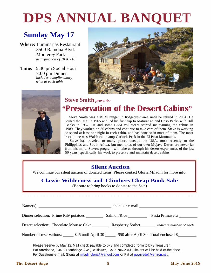
DPS ANNUAL BANQUET
Sunday May 17
Where: Luminarias Restaurant 3500 Ramona Blvd. Monterey Park near junction of 10 & 710
Time: 5:30 pm Social Hour 7:00 pm Dinner Includes complimentary wine at each table
Steve Smith presents:
“Preservation of the Desert Cabins”
Steve Smith was a BLM ranger in Ridgecrest area until he retired in 2004. He joined the DPS in 1965 and led his first trip to Maturango and Coso Peaks with Bill Banks in 1967. He and some BLM volunteers started maintaining the cabins in 1989. They worked on 36 cabins and continue to take care of them. Steve is working to spend at least one night in each cabin, and has done so in most of them. The most recent one was Walsh cabin atop Garlock Peak in the El Paso Mountains.
Steve has traveled to many places outside the USA, most recently to the Philippines and South Africa, but memories of our own Mojave Desert are never far from his mind. Steve's program will take us through his desert experiences of the last 50 years, specifically his work to preserve and maintain desert cabins.
Silent Auction We continue our silent auction of donated items. Please contact Gloria Miladin for more info.
Classic Wilderness and Climbers Cheap Book Sale (Be sure to bring books to donate to the Sale)
- - - - - - - - - - - - - - - - - - - - - - - - - - - - - - - - - - - - - - - - - - - - - - - - - - - - - - -
Name(s): phone or e-mail
Dinner selection: Prime Rib/ potatoes Salmon/Rice Pasta Primavera
Desert selection: Chocolate Mousse Cake Raspberry Sorbet Indicate number of each
Number of reservations: $45 until April 30 $50 after April 30 Total enclosed $
Please reserve by May 12. Mail check payable to DPS and completed form to DPS Treasurer:
Pat Arredondo, 13409 Stanbridge Ave., Bellflower, CA 90706-2341. Tickets will be held at the door.
For Questions e-mail: Gloria at [email protected] or Pat at [email protected].

The Desert Sage 6 May-June 2015
Type Regular Sustaining
Member 120 23
Household 28
Subscriber 25 2
Totals: 173 25
Activity Report
Achievements
Emblem
#589 Howard Steidtmann 11/22/1994
Signal Peak
#590 Tobi Tyler 6/3/2006
Montgomery Peak
New Subscriber
Jim Wick 2 years
Sustaining Renewals
David Comerzan 1 year
Burton A. Falk 1 year
Paul & Pat Nelson 1 year
Renewals
Mark Adrian 1 year
Misha Askren MD 1 year
Tina & Tom Bowman 3 years
John Bregar 1 year
Fred & Marianna Camphausen 1 year
Jim Fleming 2 years
Bill Hauser 1 year
Sue Holloway 1 year
Gene R. Mauk 1 year
Penelope Smrz 1 year
Don Sparks 1 year
Bruce Trotter 1 year
Joseph Wankum 2 years
DPS Membership Report by Ron Bartell
UPDATES ARE NEEDED TO THE CURRENT DPS ROAD AND PEAK GUIDE!!
Please send road and climbing route updates to the DPS Road and Peak Guide Editor, Jim More-
house, at [email protected]. Jim is working on a new Version 6 of the guide, so be sure
and send him a quick email after climbing a peak with suggested updates to the Guide while the in-
formation is still fresh in your mind. The DPS and Jim also welcomes volunteers to join the DPS
Road and Peak Guide Committee to assist with updating the current Guide. Please contact Jim via
email for further information.
Membership Summary

The Desert Sage 7 May-June 2015
Greetings out there!
I hope you all have
recovered from the
Chili Cook-Off. I hear
the margaritas were
good and a good time
was had by all. I was
camping in the Arctic
on Svalbard to witness
the eclipse on March
20th. What a sight!
And auroras to watch
that night also. I
learned that Svalbard is
an Arctic desert, so not
much precipitation, but
very cold. Sort of appropriate for a DPSer to visit
in a way.
Here are some notes I am passing on from Chapter
communications I have received:
The Safety Report for 2014 can be found here:
http://angeles2.sierraclub.org/sites/
angeles.sierraclub.org/files/docs/
get_outdoors/2014%20report.pdf
Accident forms and guidelines can be found at:
http://angeles2.sierraclub.org/
safety_incident_reporting
In addition, Leaders, please report any accidents or
incidents promptly to the above link.
There is a new website for Leaders (live since
December) that also incorporates the LTC, OMC
and Safety websites, which can be found at:
https://angeles2.sierraclub.org/
leadership_and_outings
For those that have not ventured out yet - do so.
There are flowers out in the desert in many
locations, including Anza-Borrego. I enjoyed them
in Jawbone Canyon last weekend. Daisies and
lupines in great profusion.
Finally, for those interested, I have an Explorer trip
Outings Chair
by Brian Smith
INCOME
Banquet Ticket Sales $560.00
Merchandise $107.00
Subscriptions $1,260.00
TOTAL INCOME $1,927.00
EXPENSES Postage for Merchandise Mailing $37.00
Sage Mailing $535.57
Sage Printing $297.98
Sales Tax $3.41
Web Page Expenses $129.73
TOTAL EXPENSES $1,003.69
CHECKING BALANCE $3,982.15
SAVINGS BALANCE $501.22
TOTAL BALANCE $4,483.37
Treasurer’s Report
by Pat Arredondo
DPS Account Summary from
January 1, 2015 to
April 6, 2015
write-up for Avawatz Mountain. The write-up is an
easy alternative to the long hike on the dirt road on the
standard route after it was closed by rock fall.
Although 18 miles, it goes easily as a day hike and has
an enjoyable "narrows" section.
I would also like to correct an error in the DPS guide
with regards to the south route to Whipple, which I did
on February 15, 2015. After leaving the trailhead, the
guide says bear left at the fork 0.8 miles in. If you bear
left, the wash gets shallow and narrow after a mile or
so to become a groove with low banks on both sides.
Climb out of the wash left onto flat desert and look for
a dirt road coming from the hillside to the right.
Follow the road less than a half mile to a wash with a
road fork. This is the fork at 1.9 miles referenced in
the guide. Stay on the road you are following and
continue to the leaching tank ruins. I could not verify
it, but the dirt road to the leaching tanks is probably
the right fork at 0.8 mile from the trailhead.
See you out there!

The Desert Sage 8 May-June 2015
Exploring the Dead Mountains Wilderness: Mount
Manchester (3,602’) and Homer Mountain (3,740’)
Leaders: Daryn Dodge and Kathy Rich
(Photos by Daryn Dodge)
February 14-15, 2015
This was our fourth scheduled Desert Wilderness
High Points trip – in part to celebrate the 50th
anniversary of the 1964 Wilderness Act. This time we
planned to climb the highpoint of the Dead Mountains
Wilderness - Mount Manchester, located in the Dead
Mountains north of Needles. These mountains got
their name because they were once a sacred burial site
for local Native Americans.
Most of our group of 9 drove in to the chosen
trailhead for this peak climb the night before, while
others chose to stay at a motel in Needles.
Participants included Bob Wyka, Scott Sullivan,
Elena Sherman, Ron Bartell, Christine Mitchell,
Keith Christensen and Wasim Khan. The trailhead we
used was 6.5 miles north of Arrowhead Junction on
Highway 95. There was plenty of parking space just
off the road here next to a sandy wash. A large sign
welcoming you to the Dead Mountains Wilderness
was posted across this wash in the direction of Mount
Manchester.
Starting at 8:00 a.m. on what proved to be a rather
warm day for February, we located an old dirt road
that runs east northeast into the Dead Mountains
Wilderness, but is now closed to motorized vehicles.
We followed the road towards the Dead Mountains
for about 1.5 miles, then split off heading more
directly for the peak. The travel across the desert was
easy and flat, with only a minor squiggle factor
around the numerous creosote bushes. As we neared
the peak, one large wash was crossed, soon followed
by another, which the group used to reach the start of
the northwest ridge of Mount Manchester. It was
here we finally started heading uphill in earnest,
although the terrain never exceeded more than Class
2. At the summit we were rewarded with a fine view
of the Colorado River and the DPS peak, Spirit
Mountain. Gordon MacLeod and Barbara Lilley had
told us that they had left a register on the summit in
1986, but sadly it was now gone. We left a
replacement register, and then returned to the cars
using the same route we
used to climb the peak.
On the way back we ran
across what appeared to be a
UXO (unexploded
ordinance). We took photos
of it; Bob recorded the
coordinates, and then we left
it as it was without touching
or disturbing it. I reported
the find to the Bureau of
Land Management when I
(Continued on page 9)
Dead Mountains Wilderness sign with Mount Manchester directly behind (photo by Daryn Dodge)
Trip Reports
Group photo on the summit of Mount Manchester,
from left to right, seated, Elena Sherman, Wasim
Khan, Kathy Rich, Christine Mitchell, and Ron
Bartell, standing, Scott Sullivan, Bob Wyka, Keith
Christensen, and Daryn Dodge.
Wasim Khan next to a
possible unexploded
ordinance found near
Mount Manchester

The Desert Sage 9 May-June 2015
got back. They were possibly going to go check it out.
Most participants thought this was a bit of a longish
trudge across the desert on a warm day. Round trip
distance was 10 miles with 1,800’ of total gain.
For camping and happy hour, we drove partway
towards our next destination, Homer Mountain.
Since Homer Mountain was just on the other side of
Highway 95, we simply drove 1 mile north from the
Mount Manchester trailhead to a pole line road and
turned west towards the peak. We followed the pole
line road for 0.8 mile, and then turned right onto a
signed Bureau of Land Management road. The group
chose a flat campsite location less than a half mile up
this road. There was a wonderful selection of food
and drink brought by everyone. Bob and Wasim had
brought firewood, so we had a nice campfire to round
out the evening.
The next morning, 7 participants remained to attempt
the summit of Homer Mountain. To get there we
continued west on the dirt road for roughly another
3.2 miles, then turned south towards the peak on
another dirt road for 1 mile until we reached an
abandoned mine. This got us just over a mile from the
summit. Overall the dirt roads to this spot were in
good shape, although 4 wheel drive is highly
recommended for going through a few short sandy
(and rocky) washes.
We walked up the road from here, although one could
have continued driving for another 0.2 mi. to where it
drops into a wash. But being only a mile or so from
the summit, I decided a short walk on the dirt road
would be a good warm-up before charging off over
moderately rocky desert terrain. We continued
southwest to the right of the wash gradually gaining
elevation. After about a half mile of walking we turn
more west heading up a ridge that brought us to the
steeper northwest ridge that leads to the summit. The
final summit ridge was rather rocky and the highpoint
was at the west end. This time a MacLeod and Lilley
register was still here at the summit, which they
climbed 2 days later after Mount Manchester back in
November, 1986. Our group was the first to sign in
since Don Palmer signed
it in 2007! Homer
Mountain does not
appear to be a major
destination for the desert
mountaineer, although
in many ways it was a
more enjoyable climb
than Mount Manchester
(i.e., more interesting
terrain, shorter hike, less
heat). While on the
summit, we thought of
many reasons to yell
“Doh!”, in honor of
Homer Simpson of the
long-running cartoon
series. Round trip
distance was 2.2 miles
with 1,300’ of total gain.
Thanks to all for an
enjoyable weekend of
desert climbing!
Conglomerate Mesa (7,724’)
By Jorge Estrada and Diana Neff-Estrada
February 21, 2015
This day, February 21, 2015, we chose to hike a
seldom climbed peak in the Southern Inyo Mountains.
Conglomerate Mesa lies just outside the west
boundary of Death Valley National Park, with terrain
mixed with Pinyon-Juniper Forest, Sagebrush and
Joshua Trees.
After a nice breakfast in Lone Pine, we headed east
on Highway 190 past the “T” Junction with Highway
136, to BLM Road S111, and headed north to another
junction, BLM Road S5 that would take us directly to
the Mesa in about 8 miles. This was a good/rough 4
wheel drive road, where at times you would be
driving in a wash.
We had explored this area a few years back after
climbing Nelson Mountain during a Thanksgiving
(Continued from page 8)
(Continued on page 10)
Trip Reports - continued...
The summit register on
Homer Mountain was
placed by Gordon
MacLeod and Barbara
Lilley on November 21,
1986
The Desert Sage 10 May-June 2015
weekend. At that time, we had approached the Mesa
from the White Mountain Talc Road to the northeast
side, and we were able to hike about half way up, but
we were turned back by snow and not being totally
sure on which chute to climb. This time, we were
more prepared and decided to try the southeast corner
of the Mesa for our ascent.
We were able to find a wide spot on the narrow road,
and parked directly across from the southeast corner
about 6,200 foot elevation. We started our hike
around 9:50 a.m. in a shallow ravine that would lead
us to the slope we wanted to climb.
From the 6,600’ level, it became very steep as we
made our way up and over very loose dirt and talus.
Without any major navigation difficulties we
zigzagged around huge boulders and reached the
mesa rim. The topo showed the high point in the back
of the mesa to the northwest. We climbed a low
summit to try to reach a vantage point to see where
we needed to go, and saw the higher ridgeline to the
northwest. The mesa was a Pinyon Pine wonderland!!
All the way up, we never saw a sign of a used trail
and headed thru easy terrain to the summit ridge and
found the highpoint. The summit register went back
to April 12, 1981
and was placed
by DPS Gordon
Macleod and
Harvey Hickman.
We were the 3rd
and 4th hikers to
sign this year!
But previously, it
had not been
signed since
February 2014.
On this perfect
cool day, we
enjoyed the views
of the White Mountains, Cerro Gordo Peak, Pleasants
Peak and Waucoba Mountain. Looking south, the
north side of Olancha Peak was snow covered. Just
below to the north/northwest was a vast flat area of
Sagebrush and Diana wanted to go and explore it. We
dropped from the summit rocks and climbed an
unnamed peak on the other side of the flats. It turned
out to be Peak 7,491’ and we were happy to get a
bonus peak.
We headed back towards the mesa via a different
route to a low point on the summit ridge. We reached
the first low summit and were back on track, spot on
where we came up.
This was Diana’s first major cross-country hike since
breaking her right foot/ankle coming down from
Mount Lamarck, courtesy of a tumbling 60 pound
boulder during Labor Day Weekend. There were a
couple of times she became anxious with all the loose
rocks while ascending and descending the southeast
slope. However, she was able to work through it, and
it was a moral victory for her.
We found our shallow gully that would take us
directly to our vehicle and were back by 3:30 p.m.
Today, we would not see anyone the entire day, and
we were truly lords of the mountain. Overall, we
logged in about 6.5 miles and 1,800’ of elevation
gain.
(Continued from page 9)
Trip Reports - continued...
Diana Neff-Estrada going up the southeast
slope of Conglomerate Mesa
The summit register on
Conglomerate Mesa was placed
on April 12, 1981 by Gordon
Macleod and Harvey Hickman.
The Desert Sage 11 May-June 2015
Palen Mountains High Point (3,848’)
By Jim Morehouse
January 2, 2015
DRIVE/ROUTE A/WESTERN APPROACH: From
Desert Center, California drive 17 miles north on State
Highway 177 to the Palen Pass dirt road, located about
10 yards north of highway milepost 17. (Or from
Twenty Nine Palms, drive approximately 40 miles east
on Highway 62 to Highway 177, turn right and
continue south to a turn off to the left, just yards from
milepost 17 and turn left, continuing on 1.8 miles of
sandy road and follow the directions below from there)
Turn right (E) and drive 1.8 miles of sandy road to a
junction. Turn right and drive 3.9 miles to a fork with a
fair dirt road coming in from the east. Park. The
boundary of the Palen-McCoy Wilderness Area is a
few feet east of this parking spot.
The above is from the DPS guide, and I came from the
north, i.e., Highway 62. The road in is definitely high
clearance and 4 wheel drive. Not because of how rough
it is, but because of how sandy it is. I engaged 4 wheel
drive on my Tacoma more for traction than anything
else.
When we arrived at the trailhead, there was a sign
saying that the road in was closed, as this was the
boundary of the Palen wilderness area. However, there
were tire tracks in that went quite a ways. Further up,
this good, but closed road, began to suffer from
numerous washouts that would have made driving it a
more serious challenge. In any case, we camped for the
night there, as it was very flat and nice. Although the
elevation is just above 500' here, the temperatures
dropped below freezing overnight.
We headed up the road about 7:00 a.m. and made good
time for the first 8.2 miles or so to get to the base of the
mountain. Lorraine and I stopped for lunch here, and
then she headed back to the truck, as her knee was
sore. From this point on the hike was over difficult,
rocky terrain. The DPS guide's directions are hard to
follow in that there are numerous forks and sub-forks
in the drainage, and at the point where I was to take the
right fork, I went left, miscounting the number of forks
that I was at!
No big deal, though, as I finally made the ridge
separating the two forks, and followed it up to the
summit ridge. The views were fantastic in all
directions.
On the way down, I went down the "correct" fork, and
made better time, as the terrain was a little better.
Several dry falls and boulder piles made the descent
interesting, although the vegetation of choice was cat's
claw. It may be possible to miss some of it, but not all
of it! Once back on the road, I flew down the road back
to camp. As it was already after dark by then, we
decided to spend another night there, and drove out the
next morning.
Trip Reports - continued...
My route is in red (the route on the left); the
better route is in blue.
This is what the route looked like at the base of the
mountain. Again, my route is in red (the route on
the left); the better route is in blue.

The Desert Sage 12 May-June 2015
Shoreline Butte (662’), Cinder Hill (-75’) and
Longridge Peak (3,110’)
Leaders: Ann and Dave Perkins
By Ann Perkins
February 21-22, 2015
The Barchells’ (Ron Bartell and Christine Mitchell)
finish of their list of 96 named Death Valley peaks
and benchmarks was a success – 25 attendees, easy
peaks, and good potluck food, as usual. Friday night
we camped about two miles in from the 127 along the
dirt but excellent Furnace Creek Wash road. We had
agreed on a leisurely start the next morning, so we
gathered at 9:00 a.m. for sign in and introductions,
and then consolidated into fewer cars to drive to the
trailhead for Shoreline Butte. Instead of driving back
to the 127 and through Shoshone, we continued on
the Furnace Creek Wash Road to its intersection with
the 178, saving about 9 miles. The road continued to
be excellent dirt. The starting point for Shoreline
Butte is at the parking lot for the Ashford Mill site,
and there was ample parking for our vehicles. Climb-
ing this peak were Ron and Christine of course; Vic
and Sue Henney, Mary Brooks and Sharon Marie
Wilcox from Reno; Anne Rolls and
Lisa Buckley from Crowley Lake;
Linda McDermott from Tehachapi;
Ann and Dave Perkins from Encini-
tas; Dave Boyle from Maine; and
Gary Craig, Michelle Gomes, Ellen
Grau, Gloria Miladin, Brian Smith,
Rich Henke, Doris Gilbert, Ron Eck-
elmann, Mirna and Greg Roach from
the Los Angeles area. We certainly
had a geographically diverse group.
Ron Grau is taking care of his knee
injury and decided not to climb, and
Julie Rush stayed behind with her
little dog.
We started at 10:10 a.m. across the
dry Amargosa River, up an alluvial
fan and a wash to the right, with sev-
eral possibilities at that point. We
probably didn’t choose the most di-
rect route, but there was plenty of
time. After about 30 minutes on the summit, we re-
turned by a better route to the cars, arriving at 1:15
p.m. It was rather hot by that time so we huddled in
the shade of vehicles and a large sign for a quick
lunch before continuing on to Cinder Hill.
Moving on to Cinder Hill, which we had seen as a
small red bump from the summit of Shoreline Butte,
we assessed the peak’s difficulty and then swarmed
up the hill by various routes. Julie
joined us for this peak. After a 100’
ascent, all attained the minus 75’ ele-
vation summit! There were congratu-
lations, photos, and champagne, and
then a general consensus that we
should go to Tecopa Hot Springs for
a soak. We drove back to the
campsite, and most of us grabbed
towels and continued to the hot
springs ($7.00 entrance fee) and re-
laxed in the warm waters. I can’t say
that we were relieving our aching
muscles since the climbs weren’t that
strenuous, but it felt good nonethe-
less. Back to the camp by about 5:00
p.m., just in time for happy hour with
wonderful dips and Christine’s great
deviled eggs, which merged into sal-
ads, stews, and desserts. Ron, Ellen
and Linda had brought wood, so
(Continued on page 13)
Trip Reports - continued...
The group on Cinder Hill; Smith Mountain
is in the background.
The two List Finishers on
Cinder Hill. Christine
thought that we should gear
up in case we ran into
anything unexpected on the
five minute stroll to the peak.

The Desert Sage 13 May-June 2015
Michelle organized a campfire, demonstrating her fire
-building skills, and we were soon gathered around
the fire while Ron B. regaled us with tales of how the
quest for this list came to be, and tales of other lists as
well.
The next morning the group went various ways. Bri-
an, Gloria, and Michelle climbed Stewart Peak from
the west, a different route from that in the guide (part
of Brian’s Explorer quest). They reported that they
made the peak after a long day and beat out the rain.
Ron and Christine, Ann and Dave, Mirna and Greg,
Anne, Lisa, and Dave Boyle climbed Longridge (948
meters, 2.5 miles ESE of Jubilee Mountain), follow-
ing Ron’s suggestion. We parked on Hwy 178 where
a dirt road goes north to Rhodes Spring, and headed
south to a saddle just east of Point 831 meters, fol-
lowing the ridge from there south to the peak. We
climbed over many ups and downs with some nice
ridge walking and some steep rock (about 2,000’ gain
and six miles), enjoying the good views from the top
– the only eventful moment was when Ann heard and
then spotted a rattlesnake rather close to the route on
the way up. She and Christine watched from a safe
distance as it rattled some more and then slid into a
hole in the rock. The register went back to a 1978
entry by Andy Smatko, referring to the peak
(unnamed on the topo) as “Longridge”. We got back
to the cars about 3:00 p.m., just before the rain started
in earnest. It was a fun weekend.
Death Valley Peaks Lists
By Ron Bartell
Christine Mitchell and I have always enjoyed climb-
ing and camping in Death Valley, starting with doing
DPS listed peaks. The first Death Valley non-DPS
peak we climbed was Striped Butte in 1989, when we
finished Manly Peak early but weren’t up to doing
Needle Peak in the afternoon, so why not something
shorter like Striped Butte, even though it isn’t on the
DPS list? In 1990 we did the last of the 19 DPS peaks
in what would become Death Valley National Park in
1994, but kept going to Death Valley and started
climbing unlisted peaks.
Before long, I decided to make a list of peaks within
the park so we’d have a definite goal to work toward.
I had most of the USGS 15’ topos covering the park,
so I decided to base the list on those maps. Any
named peak on a 15’ topo would be on the list, re-
gardless of whether it was much of a peak; so, for ex-
ample, Dantes View is on the list. And benchmarks
named on the topo would also be on the list, but some
of these weren’t even closed contours, just a point on
a ridge, so only the “worthy” benchmarks would
make the list. Peaks not named on the topos, even if
they were good peaks, would not be on the list; this
rule eliminated two excellent peaks: “Eureka
Peak” (6,604’, 8 mi SW of Eureka Dunes) and “North
Grapevine Peak” (8,460’, 3 miles NW of Grapevine
Peak). Using these rules, there was one peak, Cinder
Hill, with a summit below sea level, very appropriate
for a list of Death Valley peaks; this had to be saved
for our finish!
By around 2004 we were closing in on this list of 63
peaks, when we went on a DPS list finish trip to Sen-
tinel, where Gerry Roach was one of the finishers.
He mentioned that he had a list of Death Valley peaks
on his website. When I checked it out after the trip I
saw that his list had some peaks I’d never heard of –
they were peaks named on the new 7.5’ topos but not
on the 15’ topos. I’d completely overlooked this, but
decided I had to expand my list to include peaks and
benchmarks named on the 7.5’ maps. So after a trip to
the UCLA map library to study the 7.5’ topos, I added
33 peaks to the list; Christine was not pleased, think-
ing we’d almost been done with the list. But she’s
enjoyed the trips we’ve done to climb these added
peaks.
Several peaks are very near the park boundary, and
since many of the topos were printed before the mon-
ument expanded and became a park in 1994, it’s not
easy to tell if they’re in the park since the current park
boundary isn’t drawn on the topo. At the 2013 DPS
Banquet, the speaker was Charlie Callagan, a Death
Valley back-country ranger (who has his own Death
Valley list); I asked him about these boundary peaks,
and removed and added a couple of peaks from my
(Continued from page 12)
(Continued on page 14)
Trip Reports - continued...

The Desert Sage 14 May-June 2015
list.
Gerry Roach’s Death Valley list was the first such list
I’d heard of, but I soon learned of others. Bob
Sumner’s list turned out to have about a dozen more
peaks (unnamed on the topos) than mine, as did Rich-
ard Carey’s. Vic Henney denies having a Death Val-
ley list, but Sue Wyman says Vic just wants to climb
everything on all the Death Valley lists he can find.
Shane Smith, a few years ago, told
me he’s working on all the peaks
named on the AAA Death Valley
map, including the ones outside the
park. And then there’s Peakbag-
ger.com, which has hundreds of
peak lists, but no Death Valley list.
However, the site lets you define
your own lists; Paul Garry has de-
fined a personal Death Valley list of
63 peaks. Querying the Peakbagger
database for peaks in Death Valley
National Park comes up with 168
peaks, 6 of which have summits be-
low sea level; we’ve climbed 100 of
them, but are going to ignore the
rest for now.
Our list has three drive-ups
(Aguereberry Point, Dantes View,
and Zabriskie Point). Only two
peaks are more than class 2 (The
Grandstand, and Manly Peak’s sum-
mit block). We did four peaks as
one-night dry backpacks (Sugarloaf
Peak, Warm Benchmark, Leaning
Benchmark, Owlhead Benchmark);
we really enjoyed camping out in
the middle of nowhere on these
trips. The longest peak was Sugar-
loaf Peak, and is probably still the
longest even from the closer ap-
proach that Bob Sumner found. The
longest desert floor approach was
four miles across the valley for
Leaning Benchmark. Owl Bench-
mark and Owlhead Benchmark, on the far south
boundary, felt the most remote. The toughest drive
was getting into South Park, south of Porter Peak, to
do Park Benchmark. Our most frequent companion
was Dave Boyle, from Maine, who climbed 13 of the
non-DPS peaks on the list with us. If you’d like a
copy of our list, I’ll be glad to send it to you – see the
last page of the Sage for my contact information.
(Continued from page 13)
Trip Reports - continued...
The peaks on our list; the map is from Peakbagger.com.

The Desert Sage 15 May-June 2015
Avawatz Mountain (6,154’) – the long way
By Brian Smith
February 28, 2015
I had heard last year that rock fall had closed the dirt
road that leads to the standard trailhead on Avawatz
Mountain. I do not know how long the walk is now to
the peak from the closure, but I thought some of you
might like to hear about the other Avawatz route from
the north, which is in the DPS Guide, but not done very
often. It is, after all 18 miles round trip, though the
Guide suggests only 10 hours. Gloria Miladin and I
decided to give it a try.
The route is easy to find. Drive north of Baker on
Highway 127 to the Harry Wade Road plaque, turn left
and drive an excellent quality dirt road 1.8 miles where
you turn left on a dirt road that steadily deteriorates
into soft sand through washes and then becomes peri-
odically covered in lots of rocks. After 3.7 miles of
this, fork left near an area of ground painted white onto
a poor condition dirt road. This road steadily worsens
and drops into a wide, rough wash, whose exit requires
crossing several moraine-like, low mounds. All wheel
drive came in handy here. After 0.7 miles of this, the
road terminates at a concrete platform that used to be
the California Studies cabin. References in the guide to
a 4 wheel drive road that goes another 0.7 miles be-
yond the cabin are false. The spring with running water
and a water tank are directly adjacent to the cabin plat-
form and the road ends there. There’s also an outhouse
there.
The route from the spring involves following a wash
for over 7 miles as it slowly climbs towards Avawatz.
The first part of the wash is impassable due to thick
willows, but a use trail guides you up a foothill to the
left, above all the vegetation, then back down to the
wash once it is clear again. The wash is long and has
Joshua Trees growing in it
There is one section that is particularly interesting. A
narrows involving some 3rd class waterfalls and a
thicket with fresh, running water where we found an
almost complete bighorn ram skeleton including a skull
with big round horns attached.
After almost 7 miles, the wash climbs more steeply,
narrows and winds around more. It becomes obvious
you are nearing the end and 2 routes present them-
selves: continue in the main wash and climb the head-
wall as described in the guide, or take a side wash to
the right.
The side wash soon gets steep with loose soil, but the
climb to the ridge is only about 300’ and no rock
climbing is required. On arrival at the ridge, turn left to
a “summit” register at the end of a dirt road coming
from the nearby military reservation at Fort Irwin. This
is a goal for army patrols to navigate to, I think. Con-
tinuing on the ridge, you eventually enter a valley that
slopes up towards Avawatz.
Unfortunately, we did not realize we were looking di-
rectly at Avawatz and so hiked the left side of the val-
ley, needlessly crossing several ridges that came down
from hills to the left of us. We were aiming for a saddle
on the horizon, thinking it would lead us to our peak.
Having got there, we realized we had walked past
Avawatz and its subsidiary summit and now had to
climb its north ridge from the saddle in the teeth of a
howling gale in which it was hard to stand up and pro-
gress. Things would have been easier had we followed
the right side of the valley and climbed directly up the
subsidiary peak, which is, of course, the way we re-
turned. We reached the summit after just over 6 hours,
after 1:00 p.m. The wind was too severe to sit and eat,
so we headed back down into the valley and had lunch
at the beginning of the ridge back to the aforemen-
tioned “summit” register. We hiked back to the car un-
eventfully, arriving around 6:30 p.m. for a total elapsed
time of just over 11 hours.
Before dark we drove down the rough dirt road and
camped in a flat spot about a mile from the Harry
Wade Road. Next day, we took the DPS Guide’s ad-
vice and drove out to Saratoga Springs, noticing on the
way there that the Amargoza River was flowing quite
freely across the desert – not a common sight, I think.
The Saratoga Springs are several pools surrounded by
long reeds and bulrushes. They are quite the oasis and
we saw waterfowl, mainly coots, happily swimming in
those pools. We spent a very pleasant morning explor-
ing the area, before heading back to Los Angeles.
Trip Reports - continued...

The Desert Sage 16 May-June 2015
CHESTER VERSTEEG AND THE BIRTH
AND EARLY YEARS OF THE DESERT
PEAKS SECTION, PART 2
Presented at the Desert Peaks Section’s
Annual Banquet on May 15, 2011
By John W. Robinson
However, before gas rationing began in June
1942, two more memorable desert peak outings
were scheduled. A triple-peak trip to Cerro Gordo
Peak, Coso Peak and Maturango Peak was led by
Chester and assisted by Elsie Strand over April
11-12, 1942. With Chester again leading and
Niles as assistant, Waucoba Mountain was as-
cended in a two-day backpack over the weekend
of June 6-7, l942. Ten climbers reached the sum-
mit, again attracted by Chester’s enthusiastic
prose: “The highest peak in all the Inyo Range!
You will get a real kick out of this climb because
several of your friends - maybe you, too - will, on
the summit of old Waucoba, qualify for member-
ship in the new Desert Peaks Section.” Besides
Chester and Niles, the summiteers were Parker
Severson, Freda Walbrecht, Martin Britt, Harry
Paley, Jim Tow, Rhoda Goertz, Pat Carmical, and
Fred Johnson. Niles Werner qualified as the sec-
ond climber to ascend all seven peaks and be-
come a member of the Desert Peaks Section.
Chester gave a short speech welcoming Niles into
the section and placed a makeshift crown on his
head.
With gas rationing taking effect in June 1942,
desert peak outings were severely curtailed.
Chapter Schedule number 111 (November l942-
February 1943) proclaimed that “Scheduled ac-
tivities are temporarily suspended until the trans-
portation situation is improved.” Parker Severson
wrote that “We did manage to get some of desert
peaks that were not too far away during the war
years when gas rationing was on. Getting enough
gas was a problem. We doubled up in cars, and
got gas by scrounging gas coupons in all sorts of
devious ways, short of nocturnal raids on car
tanks.”
According to Fred Johnson, who as a teenager
climbed with the new section, there were two sig-
nificant unscheduled desert climbs during the gas
rationing period from June 1942 until September
1945. First was a climb of White Mountain on
October 12, 1942, on which Freda Walbrecht and
Harry Paley finished the seven summits and be-
came DPS member’s numbers 3 and 4. Also on
this trip was Georgie White, who later pioneered
commercial river rafting on the Colorado River.
The following year, Harry Paley, Freda Wal-
brecht, Martin Britt, Charles Hitch, and Fred
Johnson ventured into southern Nevada to climb
Charleston Peak over the weekend of September
17-19, 1943. Thanks to Harry, who had a “C” gas
coupon book, they were barely able to scrape
enough gas to make the trip.
With war’s end, all the pent-up energies of
Chester and his small band of desert enthusiasts
burst out in renewed activity. The first post-war
scheduled outing was a climb of Waucoba on No-
vember 10-12, l945, led by Niles Werner and
James Tow, announced in the chapter schedule
with the comment that “The Desert Peaks Section
comes to life again.”
Late in l945 the DPS was reorganized as a for-
mal section of the Southern California Chapter,
with dues, officers, and business meetings insti-
tuted. Chester was offered but declined the chair-
manship, so James O. Tow was elected first
chairperson. Other first officers of the DPS were
Freda Walbrecht, vice chairman; and members at
large Harry Paley, Niles Werner, and Chester
(Continued on page 17)
Chester Versteeg and the Early History of the Desert Peaks Section

The Desert Sage 17 May-June 2015
Versteeg. Membership zoomed to new heights
(23), and the beginning of l946 saw the section as
a well-established fixture of the Chapter. The
flame was now bright; no longer was it a tiny
flicker kept going solely by the eloquence of its
founder.
The year 1946 witnessed a full DPS schedule.
Peaks scheduled and successfully led were Coso
Peak and Maturango Peak, leader Parker Sev-
erson; New York Butte, Niles Werner; Telescope
Peak, Henry Greenhood; Waucoba Mountain,
Parker again; White Mountain, Harry Paley; and
Kofa Mountain, leader Parker Severson. The lat-
ter, done over the Thanksgiving weekend
(November 28-30), was the first outing away
from the trans-Sierra desert ranges. The DPS was
discovering that there were excellent peaks all
over the Southern California deserts.
Freda Walbrecht, a Los Angeles attorney of
some renown, was elected DPS chairperson in
1947. There were ten scheduled outings that year,
including the first ascent of Boundary peak and
Montgomery Peak, led by Niles Werner over the
Memorial weekend, May 30-June 1, and Charles-
ton Peak, also led by Niles, September 13-14. Al-
so in 1947 Parker Severson designed the DPS
emblem; “It occurred to me that the most fitting
symbol to use would be our noble desert animal,
the Bighorn.” The emblem was earned by climb-
ing all seven original qualifying peaks.
A word about Freda Walbrecht: She was born
in York, Nebraska, in l903. She studied law and
practiced in Oregon for eight years. She came to
California in 1934, set up a law practice in Los
Angeles, and joined the Sierra Club. Freda was a
determined woman and a competent climber in
the 1930s and into the early ‘50s. One of her ma-
jor goals was to climb all the 14,000ers in Cali-
fornia. She joined the Werners, who had the same
goal, on many of their ascents. To finish the list
she hired Norman Clyde, the Sierra’s foremost
mountaineer, as guide and load carrier. She com-
pleted all the 14,000ers, becoming the first wom-
an to do so, when Clyde led her to the airy sum-
mit of North Palisade. She was probably the only
DPSer, in those times, to be accepted for mem-
bership in the prestigious American Alpine Club.
In her later years Freda slowed considerably, but
continued to climb mountains at her own pace.
In 1948 Parker Severson was elected DPS
chairman. The year saw nine scheduled trips. The
first scheduled climb of Rabbit Peak was led by
Bill Henderson, January 31-February 1. The was
one of the last DPS outings attended by Chester
Versteeg. On the summit he pulled out pen and
paper and, inspired by the grandest and most
touching literary artistry, Wrote the epic poem
“Wild Rabbit.”
You sneak up on him, mile by mile, Foot by
foot, bit by bit. Four jaws are grim, there’s no
smile; Then a final lunge and you’ve cap-
tured it - THE RABBIT!
For seasoning use sage or wild pea, And, if
you want to pep it up a bit, Dip the meat yon-
der in the Salton Sea. Yum yum, boys and
girls, this is it - THE WILD RABBIT!
Telescope, White Mountain, Boundary or
New York Butte, You bet, we like ’em all a
bit. But today - no steak tough as a climber’s
boot; Today, tender and sweat, this is it -
WILD RABBIT
Parker Severson later added a final stanza:
Alas, what prompts we mortals so vain, To
(Continued from page 16)
(Continued on page 18)
Chester Versteeg and the Early History of the DPS - continued...
The Desert Sage 18 May-June 2015
pursue this mighty sore-muscle game; Plod-
ding with sweat and tears through storm and
rain, To crown these noble summits with our
name? - WILD RABBIT
In subsequent years, numerous other climbers
added their own stanzas to the epic poem.
The DPS bylaws authorized the section to
schedule two Sierra Nevada outings each year.
The first and only one in 1948 was a climb of
Olancha Peak, June 19-20, led by Niles Werner.
The first DPS Triennial Banquet was held at the
Hollywood Athletic Club , May 4, 1948. “It was
a tremendous clambake,” wrote Parker Severson,
“The only important person who wasn’t there was
the Governor.” The speaker was Dr. James Bon-
ner of Caltech.
In 1949 Henry Greenhood became DPS chair
person. There were 11 scheduled trips that year,
including the first scheduled climb of Glass
Mountain, May 28-30, led by Bill and Margie
Henderson; Lone Pine Peak in the Sierra, August
13-14, under Parker Severson; and Henry Green-
hood and Antonio Gamero’s Idyllwild to Palm
Springs traverse, October 1-2.
Changes came to the DPS list of qualifying
peaks during the l947-1949 period. The Section
played “tag” with the U.S. Navy. Coso Peak and
Maturango Peak, both within the boundaries of
the China Lake Naval bombing range, were delet-
ed, added, deleted, added again and deleted a
third time during the late ‘40s and early 50s. 1947
to 1949 witnessed the expansion of the list of
qualifying peaks from seven to l6, with the addi-
tion of Boundary Peak, Montgomery Peak,
Grapevine Peak, Castle Dome Peak, [Little] Pica-
cho Peak, Martinez Mountain, Rabbit Peak, Glass
Mountain, Dry Mountain, and Sentinel Peak. The
new emblem requirement remained at seven
peaks, but required the climbing of four newly
designated emblem peaks: New York Butte,
Montgomery Peak, Telescope Peak, and Rabbit
Peak, the latter the first emblem peak away from
the trans-Sierra ranges.
During the late l940s and early ‘50s, a number
of noteworthy individuals joined the Desert Peaks
Section and contributed much to the organization.
Their names deserve to be remembered. Other
than those already mentioned, this “honor list” of
those who should not be forgotten are Lloyd and
Rosemarie Balsam, Eric and Elsie Kent, Willard
and Marion Dean, Bill and Betty Crookston, Bob
and Emily Bear, John Del Monte, Luella Todd,
Virgil Sisson, Irene Charnock, Walter and Ber-
nice Heninger, Sam Fink, Alda Van Pappelen-
dam, Antonio Gamero, Tom and Trudie Hunt,
and Georgie White who, as previously men-
tioned, became the “first lady” of Grand Canyon
rafting. One early DPSer still active today is our
own Barbara Lilley, who was climbing with the
section as early as 1950.
1950 saw the birth of the DPS Newsletter, ed-
ited by section chairman Bill Henderson and ably
assisted by his wife Margie. Bill believed that
communications between the Management Com-
mittee and the section’s membership would be
improved if he wrote a letter to the membership
to keep them abreast with activities and issues
pertaining to the section. He did just that. The
nine newsletters issued during Bill’s term of of-
fice were addressed to “Dear Member”, written in
the first person and signed by Bill. So began, 61
years ago, the long saga of today’s Desert Sage.
Chester Versteeg retired from DPS activities
in 1950, well satisfied with the progress and pop-
ularity of the section. Always restless by nature,
(Continued from page 17)
(Continued on page 19)
Chester Versteeg and the Early History of the DPS - continued...

The Desert Sage 19 May-June 2015
THE DESERT PEAKS SECTION NEEDS MEMBERS TO RUN FOR THE
DPS MANAGEMENT COMMITTEE.
Please contact any Management Committee member if you’re interested in serving on the
Management Committee.
Chester pursued other projects.
As an alumnus of the University of Southern
California, he noticed that there were Sierra
peaks honoring Stanford University and the Uni-
versity of California (University Peak), but noth-
ing to honor his institution. To remedy this, Ches-
ter organized and led an ascent of a then-
unnamed 13,968-foot summit about five airline
miles north of Mount Whitney and proposed the
name “ Trojan Peak.” The U.S. Board on Geo-
graphic Names, at the request of Chester and uni-
versity president Dr. Fred Fagg, accepted the
name Trojan Peak and the pool of water below it
as Lake Helen of Troy. In 1951, shortly after the
names were accepted by the USBGN, Chester
founded the Trojan Peak Club, open to interested
U.S.C. students and alumni.
In his later years, Chester worked on a history
of the Sierra Nevada, interviewing over 400 pio-
neers and other persons with knowledge of the
Range of Light. But he was beaten to the punch
by Francis Farquhar’s superb history of the range
published by the University of California Press in
1964.
Chester Versteeg, 76 years old, passed away
on November 2, 1963. Perhaps his greatest lega-
cies were the 250-odd Sierra peaks, passes, lakes,
and meadows he named, and as “founding father”
of our Desert Peaks Section.
One more Sierra place name needs to be men-
tioned. At the urging of Chester’s many friends,
The United States Board on Geographic Names
accepted the name “Mount Versteeg” for a
13,470-foot summit on the Sierra crest immedi-
ately north of Trojan Peak. Over the Labor Day
weekend of 1965, I led a dedication climb of
Mount Versteeg, sponsored jointly by the SPS
and the DPS, unfurled the Versteeg family flag,
and placed a register on the summit containing a
synopsis of Chester’s life and accomplishments.
SOURCES: Los Angeles Times, Sierra Club Bul-
letin, Pacific Pathways, various issues. Interview
with Mrs. Lillian Versteeg, Chester’s widow, in
Laguna Niguel. Selected Chester Versteeg papers
and correspondence donated by Mrs. Lillian Ver-
steeg. Interviews with Louise Werner, in Alham-
bra and later at the Artesia Christian Home. Cor-
respondence with Parker Severson, Freda Wal-
brecht, Fred Johnson, Bill T. Russell, Charles
Knapke, Dennis Kruska, John Ripley, and Robert
Cates, the latter Chair of the Angeles Chapter’s
History Committee.
Note: Part 1 of this article was published in
the March-April issue of the Desert Sage
(Continued from page 18)
Chester Versteeg and the Early History of the DPS - continued...

The Desert Sage 20 May-June 2015
Great Basin Peaks Section News
The Great Basin Peak List
By Sharon Marie Wilcox
As spring approaches, more peaks are snow free, which
increases opportunities to work on the Great Basin
Peaks list. Who will be out hiking in the Great Basin
this season? The following members have provided their
peak numbers to show their current progress:
Robert Stolting: 9
Mitch and Janice Brown-Silveira: 21
Laura Newman: 22
Kathy Rich: 23
Marge Sill: 24
Daniel Baxter: 24
James Barlow: 29
Bob Morrill: 35
James Morehouse: 36
Tobi Tyler: 46
Howard Steidtmann: 49
Dave Porter: 54
Randy McNatt: 59
Charlie Winger: 64
Mary Brooks: 66
Daryn Dodge: 67
Ken Jones: 75
Sharon Marie: Wilcox 80
Larry Dwyer: 92
John Ide: 114
Looks like a new list finish is on the horizon!
We’ll check back as autumn ends to see everyone’s pro-
gress, plus add others that decide to share their peaks.
Our Toiyabe Chapter webmaster, Dennis Ghiglieri, has
our new website format done. Check it out on the link
below. Thanks Dennis!
We now have a page on Facebook. Please add pictures
or reports from your trips to share with other hikers.
Join the GBPS! For details on membership, recognition
categories, peak list, and trip reports check out Great
Basin Peaks Section at: http://www.sierraclub.org/
toiyabe/great-basin-peak-outings
Exploring Our Public Lands on Great Basin Peaks
By Sharon Marie Wilcox
In March, Larry Dwyer led a group up Pah-Rum Peak
(7,608’) as a joint Sierra Club/Friends of Nevada Wil-
derness outing. Pah-Rum is located in the Fox Range
Wilderness Study Area and is the range highpoint. Our
route headed up Rattlesnake Canyon for a pleasant,
steep hike to the summit for about 2,600’ gain and 6
miles round trip. For those interested in peak lists, Pah-
Rum is also a Nevada prominence peak. Great Basin
Peaks promise spectacular summit views. During lunch,
we viewed Pyramid Lake to the south, the Smoke Creek
Desert, San Emidio Desert, plus many notable surround-
ing peaks still visible on this cloudy day.
Larry also planned a hike to Rawe Peak (8,343’) at the
north end of the Pine Nut Range. The Old Como Road
out of Dayton leads to the hike’s starting point. The
rough, rocky road passes the old mill ruins and town site
of Como adding a possible exploration of the historical
1860’s mining town. This hike has some minor rock
scrambling and brushy areas varying in distance de-
pending on your starting point. Our parking spot gave us
about 1,500’ gain and 6 miles round trip. Our bonus was
a nice black bear track in the mud.
Thanks Larry for planning these two enjoyable outings
and sharing information on the difference between wil-
derness areas, wilderness study areas, and areas with
wilderness characteristics. These hikes are possible to
enjoy because of public lands. Public lands enable us to
access the many peaks and outdoor areas we all enjoy.
To help preserve and protect our public lands please,
email the members of the Nevada Senate and ask them
to vote No on Senate Joint Resolution 1. This resolution
would transfer a majority of public lands into state and
private control, preventing us from enjoying their end-
less opportunities. Public lands are currently managed
by the BLM and U.S. Forest Service, and contain many
recreation areas and critical wildlife habitat. Lets work
to keep them public.
The Desert Sage 21 May-June 2015
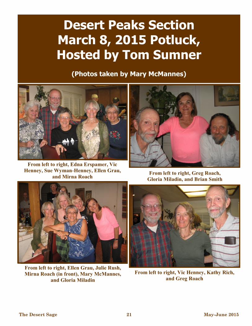
Desert Peaks Section March 8, 2015 Potluck, Hosted by Tom Sumner
(Photos taken by Mary McMannes)
From left to right, Vic Henney, Kathy Rich,
and Greg Roach
From left to right, Edna Erspamer, Vic
Henney, Sue Wyman-Henney, Ellen Grau,
and Mirna Roach From left to right, Greg Roach,
Gloria Miladin, and Brian Smith
From left to right, Ellen Grau, Julie Rush,
Mirna Roach (in front), Mary McMannes,
and Gloria Miladin

The Desert Sage 22 May-June 2015
Desert Peaks Section Chili Cook-off March 21-22, 2015
Hosted by Julie Rush, Laura Webb and Jan Brahms
(Photos taken by Mike Sandford)
The 21st Annual DPS Chili Cook-Off
March 21-22, 2015
Co-Hosts: Julie Rush, Jan Brahms & Laura Webb
By: Julie Rush
After a gallant effort to plan a fall event near Death
Valley, finding a more suitable venue for a gathering
of the chiliphiles was a bit of a challenge. Anza
Borrego Desert State Park came to mind, and with the
assistance of desert denizen Laura Webb, we scoured
the park for four days in early January, 4-wheeling
thru the outback of the
park in all directions
looking for a “home”,
as it were. Culp Valley
Primitive Campground
proved to be a lovely
space for all 41 partici-
pants! After all, it was
to be the first day of
Spring, and the desert
bloom did not disappoint us. Spring wildflowers were
impressively gorgeous.
As co-host and chief parking attendant for the event, I
was able to crea-
tively make room
to have all nine
cooks encircled
around a pictur-
esque landscape of
granite boulders
and silver cholla.
Early arrivers en-
joyed day hiking
to Maidenhair
Falls and Pena
Springs and later,
an intimate camp-
fire and camaraderie with a starry, windless Friday
evening. Although many busy hikers arrived through-
out all of Saturday, a space for car and tent camping
was able to be procured for all! By noon all cooks
were present, and commenced to sauté, scorch, sear,
grill, poach, reduce, steep, stew, simmer (and even
freeze) their secret
recipes, all the
while scheming,
concocting and con-
triving ways to get a
vote. Elena Sher-
man modeled her
enviable “Breaking
Bad:” yellow apron
as on-lookers re-
laxed, hiked, flow-
ered, birded or so-
cialized.
Fresh-lime margari-
tas, from mixicologist Bob Wyka, and also provided
in-absentia by Brian Smith-on-a-stick who was in
Norway to observe the solar eclipse, commenced to
flow some time (hard to remember) before the 4:30
p.m. gathering for happy hour and Cooks’ Introduc-
tion. The chili contestants were expressive if not in-
ventive. Their limitless promises of delectable, culi-
nary experiences sounded more like bribery for votes
to me. Why, even Gloria Miladin used child labor, her
adorable grandchildren, Hannah and Lucas, to pluck
the voters’ heartstrings!
The ballot package (creatively made by Dave Bald-
win!) was passed out to all the qualifying tasters who,
after passing strict voting regulations requiring 2 pic-
ture IDs and proof that they could still read and write,
grabbed their spoons to begin their quest for the “Best
(Continued on page 23)
Opuntia Cactus
Julie Rush, parking attendant
extraordinaire!
How many DPSers does it
take?

The Desert Sage 23 May-June 2015
Desert Peaks Section Chili Cook-off -continued...
Chili” stopping now and again to refresh their marga-
ritas. A cake was offered by Karen to celebrate Ron
Hudson’ s birthday, and the usual happy hour fare was
enjoyed by all. And as the ballots began to be tallied,
the campfire soon became the gathering place for the
well-watered and chili-contented.
The award presentation began a little later and was
lively and thoroughly entertaining. Thanks to our
“calligrapher-of-the-desert”, Elaine Baldwin, for hand
-lettering the winners’ names for each certificate—by
camp light no less!
Here are the ballot results for the 21st Annual DPS
Chili Cook-Off:
Best Overall: Peter Christian “Anza-Pedro”
Best Traditional: Kelley Laxamana “G.O.T.
Chili ?” (Good Ole Traditional Chili)
Best Texas Style: Laura Webb“Tex (New) Mex”
Best Vegetarian: Linda McDermott “Dirty Dog”
Spiciest Chili: Peter Christian “Anza Pedro”
Most Original Recipe: Gloria Miladin with Hannah
and Lucas Heintz “Chilly-Chili Ice Cream”
Best Presentation: Mirna Roach “Tango Turkey”
Honorable Mention: Ann Perkins’s “Chili Buck”, Ja-
net Damen’s “Carne Comfort” and Karen Andersen’s
“Veggie-Delish”
A special recognition gift was also given to Dave and
Elaine Baldwin for their tireless efforts as Cook-Off
hosts over the last five years.
(Oh, if anyone did not get the microwave potato bag
instructions, contact me for them and enjoy.)
Early Sunday morning, a hike to Wilson Benchmark
and Pinyon Ridge enticed 12 participants, and other
folk slowly broke camp and headed for various needed
peaks, high points or hot springs on their way home.
Some of us sauntered up the newly built Culp Valley
Lookout Trail to admire the prolific flower bloom and
view the Borrego Valley and beyond. Great to see all
those daunting peaks like Villager and Rabbit in the
distance, which most of us have hiked at least once.
The 21st DPS Chili Cook-Off was a wonderful gather-
ing of old and new friends, with great food, good
drink and bad jokes. I could not have even begun such
a feat without Laura Webb and Jan Brahms. Jan was
not able to attend the weekend, but her organizational
and graphic design work were top notch. I’d like to
add one more thing. With the generous approval of all
the cooks, proceeds of $100 has been donated to the
Anza Borrego Foundation, the organizational arm that
works to protect, preserve and expand our Anza
Borrego Desert State Park.
So, here’s to the 22nd DPS Chili Cook-Off to come.
Hosts will be Gloria Miladin, Julie Rush and Linda
McDermott. We are crazy gals to volunteer for this,
but we like to have fun in the desert.
See more pictures in a quick slideshow that can be
viewed at this link:
https://21stdpschilicookoff.shutterfly.com/
(Continued from page 22)
The cooks, from right to left, Peter Christian,
Karen Andersen with Ron Hudson, Linda
McDermott, Mirna Roach, Ann Perkins, Laura
Webb, Gloria Miladin with Hannah and Lucas
Heintz, Kelley Laxamana, and Janet Damen.

The Desert Sage 24 May-June 2015
EAST ORD MOUNTAIN
A few pieces ago, I “dissed” East Ord as the
“Rodney Dangerfield” list peak that “don’t get no
respect”. On reflection, I decided I should try to dig
up something interesting about it and give it its
chance at a place in the (desert) sun. And, while it
is probably on no one’s list of the ten “favorite” or
“most beautiful” List peaks, its outwardly drab
rocks, when examined, actually tell the whole story
of the plate collision that has shaped the West…
from B.C. (before collision) to its aftermath! (No
glacial geology this time).
Although part of the highest range in this part of
the Mojave, topping out at 6,309’ on (Middle) Ord
Mountain, East Ord starts with a big disadvantage;
no pretty rocks. No shining granite palisades like
Big Picacho; no picturesque giant boulders like
Coxcomb; no massive limestone cliffs like Charles-
ton; no rainbow sandstone like Guardian Angels or
Bridge. Just kind of a dense dull gray-blackish
stone, weathering brownish, good for cobblestones
maybe but nothing to write home, or articles, about.
This is mostly because, this far west, we’re largely
in the roof of the engine room of the Nevadan orog-
eny. “Pretty” sedimentary rocks tend to form in qui-
eter, lower-energy environments. Pretty granite
forms deep in the engine room; Sierran-age granite
does crop out in the Ords and likely underlies them
at depth, but here we’re just mostly in the cooked
peripheral zone. And yet…careful geologic study of
these drab rocks reveals the entire history of the
Nevadan orogeny and subsequent events. (Most of
this piece is adapted from “Geology and Mineral
Deposits of the Ord Mountain District, San Bernar-
dino County, California” by F. Harold Weber, Jr.
[California Division of Mines & Geology Special
Report 77, 1963])
On the west side of East Ord is exposed a total
of 2,000 feet of quartzite (metamorphosed sand-
stone) and marble (cooked limestone) intruded by
Nevadan (Mesozoic) granite. Any fossil infor-
mation in these rocks was destroyed long ago, but
from regional relations this has to be a remnant of
the great sedimentary sequence laid down over
more than a quarter billion years on the quiet conti-
nental margin we’ve discussed before which lasted
from the Precambrian to the end of the Paleozic (ca.
250 MYA). As we go west in the Mojave, these
remnants become increasingly scattered, mangled
and cooked.
Although nowhere visibly in contact with the
ancient sediments, the next oldest rock is an enor-
mous thickness of mostly andesitic volcanics, with
interbedded rhyolites, basalts, and tuff (lithified
ash) at least 16,500’ thick. This is the hard, fine-
grained, dense, drab rock that makes up most of the
route on East Ord. This sequence itself has been
metamorphosed by even higher heat and pressure
after it formed, and thereby hangs a tale. We date
these rocks as Triassic (251-199 MYA) -- the be-
(Continued on page 25)
The Rocks We Climb by Bob Michael
East Ord Mountain from the south

The Desert Sage 25 May-June 2015
ginning of the Great Tectonic Plate War of the Ne-
vadan orogeny – as they are intruded at the base by
typical younger Jurassic-Cretaceous Nevadan gran-
ites. (Remember, this happened at great depth.) An-
other clue connecting these rocks with the Triassic
start of continental-margin subduction volcanism is
the fact that they’re mostly andesite – yes, from
“Andes” – the signature rock of this process. (In my
Atacama article a few years back, I mentioned that
mile after endless mile of andesite became almost
monotonous.) So we have the whole story of conti-
nental-margin subduction tectonics – first, massive
surface eruption of and esites, later buried and in-
truded at depth by granites generated later and
deeper in the process – in these at-first-glance bor-
ing rocks. (Some of the airborne ash from these left
-coast volcanoes drifted east over the quiet Triassic
backwater of the Colorado Plateau and fell out, cre-
ating what Ed Abbey wonderfully called the
“poisonous Chinle badlands”).
As is the story with other Basin and Range-type
mountains, after the Nevadan orogeny spent itself
there was great regional uplift and erosion, exhum-
ing rocks that had formed at great depths. The Mio-
cene (23 to 5 MYA) was, here as elsewhere, a time
of great crustal extensional stress, forming both
strike-slip (lateral) and normal dip-slip, or uplift,
faults in this area. The lateral faults in the south-
western Mojave have a northwest-southeast-
trending grain, which suggests that they were
shaped by the regional crustal stress field caused by
the opening of the lateral northwest-southeast San
Andreas system to the southwest. From cross-
cutting relationships, it appears that this cracking
opened up pathways for hot, chemically-rich fluids
to rise from somewhere in the depths and precipi-
tate out as ore-bearing veins in the cooler, lower-
pressure near-surface regions. This gave us the me-
tallic deposits of the historic Ord Mountain Mining
District, predominantly copper but including values
in gold and silver, even tungsten and molybdenum!
Precise figures are not known but from old mine
records a total of about 2,000 tons of ore were
shipped between 1898 and 1953.
As a final touch – even in the Ords we find an
odd summit plateau of subdued relief with steep
sides all around, something I’ve written about in
my past two pieces on the Whites and Toquimas.
The 6,309’ summit of (Middle) Ord Mountain, an
off-list bag (accessed by a rough 4 wheel drive
road; I had to start from the bottom) is one of these!
Another ancient uplifted erosion surface? Even one
of our (at first glance) least interesting peaks has
many stories to tell!
(Continued from page 24)
SAGE PHOTOS AND REPORTS NEEDED !!!
The SAGE needs articles and photographs, including cover photos, that pertain to outdoor activities of interest to Desert Peak Sections members and subscribers. Please note that trip reports should include trip dates and identify trip participants and photos should indicate when and where the photo was taken, what it is of, who is in it, and who took it. Please email SAGE submissions to [email protected] no later than the second Sunday of even numbered months.
The Rocks We Climb - continued…
The Desert Sage 26 May-June 2015
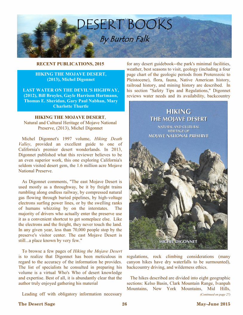
RECENT PUBLICATIONS, 2015
HIKING THE MOJAVE DESERT,
Natural and Cultural Heritage of Mojave National
Preserve, (2013), Michel Digonnet
Michel Digonnet's 1997 volume, Hiking Death
Valley, provided an excellent guide to one of
California's premier desert wonderlands. In 2013,
Digonnet published what this reviewer believes to be
an even superior work, this one exploring California's
seldom visited desert gem, the 1.6 million acre Mojave
National Preserve.
As Digonnet comments, "The east Mojave Desert is
used mostly as a throughway, be it by freight trains
rumbling along endless railway, by compressed natural
gas flowing through buried pipelines, by high-voltage
electrons surfing power lines, or by the swelling ranks
of humans whizzing by on the interstates. The
majority of drivers who actually enter the preserve use
it as a convenient shortcut to get someplace else. Like
the electrons and the freight, they never touch the land.
In any given year, less than 70,000 people stop by the
preserve's visitor center. The east Mojave Desert is
still...a place known by very few."
To browse a few pages of Hiking the Mojave Desert
is to realize that Digonnet has been meticulous in
regard to the accuracy of the information he provides.
The list of specialists he consulted in preparing his
volume is a virtual Who's Who of desert knowledge
and expertise. Best of all, it is abundantly clear that the
author truly enjoyed gathering his material
Leading off with obligatory information necessary
for any desert guidebook--the park's minimal facilities,
weather, best seasons to visit, geology (including a four
page chart of the geologic periods from Proterozoic to
Pleistocene), flora, fauna, Native American history,
railroad history, and mining history are described. In
his section "Safety Tips and Regulations," Digonnet
reviews water needs and its availability, backcountry
regulations, rock climbing considerations (many
canyon hikes have dry waterfalls to be surmounted),
backcountry driving, and wilderness ethics.
The hikes described are divided into eight geographic
sections: Kelso Basin, Clark Mountain Range, Ivanpah
Mountains, New York Mountains, Mid Hills,
(Continued on page 27)
DESERT BOOKS By Burton Falk
HIKING THE MOJAVE DESERT,
(2013), Michel Digonnet
LAST WATER ON THE DEVIL'S HIGHWAY,
(2012), Bill Broyles, Gayle Harrison Hartmann,
Thomas E. Sheridan, Gary Paul Nabhan, Mary
Charlotte Thurtle
The Desert Sage 27 May-June 2015
Providence Mountains, Granite Mountains, and Lanfair
Valley, all of which are accompanied by excellent maps
“hand drawn on a computer by the author from USGS
topographic maps.” The book’s photos and sketches,
also top drawer were shot or drawn by Digonnet.
Of special interest to DPS members are Digonnet's
guides to climbing three list peaks, Clark Mountain,
New York Mountain, and Granite Mountain (north),
in which some of his information came as a surprise to
me.
For example, I didn't realize that the upper drainage of
the Cottonwood Wash, including all of the Cottonwood
Basin--the route by which I climbed Granite Mountain
many years ago--is now a part of the Sweeney Granite
Mountains Desert Research Preserve, and that public
access is strictly prohibited. Digonnet climbed Granite
from the north side, via Bull Canyon, a more difficult
route which took him 11 hours to complete.
Furthermore, I was not aware that access to Edgar
Peak (and Fountain Peak, Mitchell Caverns and the
Providence Mountains Campground) was no longer
possible. Due to the 2011 cutbacks in the California
State budget the entire Providence Mountains State
Recreational Area, which is enclosed by but not a part
of the Mojave Desert National Preserve, is closed until
further notice.
To give you a sample of Digonnet's excellent
descriptions, consider the following samples:
Kelso Dunes: "Rising 500 feet above their
surrounding, the spectacular Kelso Dunes are the
second tallest in the California Desert, exceeded only
by the Eureka Valley's mighty dunes. Climbing their
highest summit is understandably the preserve's most
popular hiking destination. Yet the Kelso Dunes are so
vast that they offer endless possibilities for enjoying the
magic world of sand in seclusion--the immense barren
playas, the rippled slopes, the sensual hollows and
finely sculpted crests."
Soda Lake: Hiking across Soda Lake "is a muddy,
slushy, tedious business. It is so messy you may not
even make it through. But this hike throws you
instantly into a different world. The landscape vibrates
with the surreal light reflected by the salt pan...This is
tantalizing scenery, alien and raw yet strangely
attractive."
Cima Dome: "About 10 miles across but only 1,200
feet tall, Cima Dome is more like a swelling than a true
mountain. Yet it is a special place: it is host to the
world's largest Joshua Tree forest, and it holds the
record for the most symmetrical dome in the United
States " Not the "world's prestigious mountain...but it is
a geological oddity, and climbing it is so easy it's hard
to pass up."
In addition, Digonnet's historic notes are well-
researched and interesting.
"The combined output of all the historic mines in the
New York Mountains probably did not exceed a few
hundred thousand dollars." However, "by establishing
early on the presence of mineral assets in the east
Mojave Desert, it sparked further prospecting and
additional strikes....(I)n 1881 a reduction plant was
installed in Needles, even before the town was
founded...A railway...was constructed across Lanfair
Valley to connect the mines to the mill," which,
although short-lived, helped open the area "to
homesteaders and supported...other mines as far north
as Death Valley. Ironically, this beneficial
infrastructure stemmed from a mistake--a gross
overestimation of the New York Mountains' mineral
worth."
Hiking the Mojave Desert is a gem, 452 pages in
length, including descriptions of approximately 150
hikes, and, best of all, the author's personal comments
on each.
Digonnet is also the author of Hiking Western Death
Valley National Park (2013), and is currently preparing
another volume Hiking Joshua Tree National Park. I
can't think of a better speaker for a future Desert Peaks
Section function.
LAST WATER ON THE DEVIL'S HIGHWAY,
A Cultural and Natural History of Tinajas Altas,
(2012), Bill Broyles, Gayle Harrison Hartmann,
Thomas E. Sheridan, Gary Paul Nabhan, Mary
Charlotte Thurtle
Since Desert Books began reviewing desert-themed
(Continued from page 26)
(Continued on page 28)
Desert Books - continued...

The Desert Sage 28 May-June 2015
volumes sixteen years ago, El Camino del Diablo (The
Devil's Highway), the historic route across
southwestern Arizona, and Tinajas Altas, a series of
natural tanks close by the Camino, have been
considered on many occasions.
Indeed, arranged alphabetically by author, this
column has reviewed the following volumes referring to
that vast, arid expanse located between the Rio Sonoyta
and the Colorado River: Dead in Their Tracks, John
Annerino; Outpost of Empire: A Biography of Eusibio
Francisco Kino, Anza’s California Expeditions, Herbert
Bolton; Blue Desert, Charles Bowden; Sunshot, Bill
Broyles; Desert Gold, Zane Grey; Desert Heart:
Chronicles of the Sonoran Desert, William K.
Hartmann; The Sierra Pinacate, Julian D. Hayden;
Camp-Fires on Desert and Lava, William T. Hornaday;
Last Stand at Papago Wells, Louis L'Amour; New
Trails in Mexico, Carl Lumholtz; The Desert Smells
Like Rain, Gary Nabhan; The Devil's Highway, Luis
Urrea; and Lady Bought With Rifles, Jeanne Williams.
Until 2012, however, when Last Water on the Devil's
Highway finally arrived in bookstores, there had been
no one-volume devoted wholly to the cultural and
natural history of Tinajas Altas and El Camino del
Diablo
The genesis for Last Water on the Devil's Highway
dates back to the late 1990s, when the U.S. Air Force,
then the overall manager of the Barry M. Goldwater
Range, proposed to fund a project that would research
the history and significance of the area.
And although many authors contributed to the original
two-volume work, The Only Water for 100 miles,
published in 2000, only five co-authors, Broyles,
Hartmann, Sheridan, Nabhan, and Thurtle, followed
through on the notion that the scientific report should be
amended into "a more accessible book that would
explain why Tinajas Altas is a magical place worthy of
respect and preservation."
Last Water on the Devil's Highway, the resulting user-
friendly version, published in 2012, leads off with an
introductory chapter, "Desert Water," explaining the
area and why it remains of such great intrinsic value.
Specifically, Tinajas Altas and the Devil's Highway
are located in the region known as the Western
Papagueria. a swath of northwestern Sonora and
southwestern Arizona bounded by the Sonoyta River on
the east, the Colorado River on the west, the Gila River
on the north, and the freshwater seeps along the coast of
the Gulf of California on the south.
The word tinaja is Spanish for an earthenware jar,
while Tinajas Altas (generally translated as 'High
Tanks') "is a name which also applies to the mountain
range containing (the) string of pools, a nearby pass,
and an adjacent archaeological site used extensively in
both prehistoric and historic times."
Located in a steep 400' defile in the east face of the
Tinajas Altas Mountains, the fifteen natural water
catchments, "varying in size from a wash bucket to a
backyard pool," have been estimated to hold at least
20,000 gallons of water when full.
The source of water in that otherwise waterless area
has been important to humans for millennia. For Native
Americans--most recently the Hia C'ed O'odham, a
western branch of the O'odham; for untold numbers of
Spanish and Mexican-era explorers; and, in the 1850s,
(Continued from page 27)
(Continued on page 29)
Desert Books - continued...

The Desert Sage 29 May-June 2015
for the travelers on their way to and from the gold fields
of California, to find water there was often a matter of
life and death.
But is the water of Tinajas Altas actually potable?
Indeed, water that stands in natural tanks year round can
contain an "odd mix of bacteria, viruses, toxins, dead
animals, salts, and unusual chemical and mineral
concentrations." Raphael Pumpelly, traveling along the
Camino with his family in 1915, wrote this of the water
they found in nearby Tule Tank: "Its water was both
brackish and offensive, but facing thirst on the desert
one can't be squeamish. Several months later a friend
who had been over that route on a survey asked: 'How
did you like the Tule water?' 'Not much,' I answered.
'Naturally,' he said, 'for we found and left a man in it
two years ago.'"
The chapter, "First Europeans to Forty-Niners,"
explains the problem in determining who the first
European was to stop at Tinajas Altas. In the fall of
1540, following his conquest of Cibola in western New
Mexico, Francisco de Coronado dispatched Captain
Melchior Diaz to travel west to the Colorado River to
rendezvous with Hernando de Alarcon, who, sailing up
the Gulf of California and ascending the Colorado
River, was meant to deliver much-needed supplies for
Coronado's expedition. Although the mission failed (in
fact, Diaz himself died during the endeavor), his men
may have visited the tanks both going from and
returning to New Mexico.
The historian, Herbert Bolton (1870-1953), believed
that the Jesuit Father, Eusebio Kino, stopped at Tinajas
Altas in February, 1699, during his first expedition from
north-central Sonora to the Colorado River. Later
historians disagree, however, claiming that what Bolton
thought to be Tinajas Altas was instead the Cabeza
Prieta Tanks, some 15 miles to the east. Because the
problem of accurate distance measurements--in Kino's
time distance was calculated in leagues, a league being
the distance that could be traveled in an hour--and
because Kino's notes are often contradictory, whether or
not the Padre was the first to visit Tinajas Altas may
never be resolved.
Another Jesuit Father, Jacob Sedelmayr, probably
stopped at the tanks while returning from his missionary
trip to the Colorado River in 1750, while Captain Juan
Bautista de Anza apparently just missed the Tinajas
Altas on his brilliantly-led Mexico to California and
return expeditions of 1774 and 1776.
In 1770, in order for the Spanish to secure their
overland route to California, two missions and a village
of Hispanic settlers were established near the junction
of the Gila and Colorado rivers. In July 1771, after
continued mistreatment by the Spanish, the Quechan
(Yuman) Indians rebelled and slaughtered more than
100 soldiers, priests (including Father Francisco
Garcés, the first European to cross the Mojave Desert,),
and settlers. It wasn't until the California Gold Rush
some seventy years later that the trail was reopened.
It is estimated that at least 20,000 gold seekers
followed the Southern Route, via portions of El Camino
del Diablo and the Yuma Crossing, in their haste to
reach the gold fields. "Hundreds died along the way,
some of them buried at Tinajas Altas. This is when the
trail acquired its hellish name."
Last Water on the Devil's Highway describes the 1854
Gadsden Purchase, in which the U.S. purchased from
Mexico much of southern Arizona, including the
Tinajas Altas area and most of the Camino del Diablo.
Accounts of the subsequent border surveys--the 1854
Emory Survey, and the 1891-1896 U .S. Army Corps of
Engineers survey, both of which provided the first
accurate maps of the area--are also explored.
Use of the Camino dwindled rapidly after 1880, when
the Southern Pacific Railroad completed its line
between Los Angeles and Tucson, and except for a few
hardy campers the Tinajas Altas area remained
relatively untouched until 1941, at which time the
military acquired virtually all the land south of what is
now Interstate 8, between Yuma and Ajo, for the Luke
Air Force Gunnery Range.
Last Water on the Devil's Highway is replete with
excellent photos and maps--both historic and recent; a
brief natural history, including appendices on the
region's mammals, birds, amphibians, reptiles and
vascular plants; and a brain-numbing list of references.
Published by the University of Arizona Press, this 274
page, quarto-size volume is an excellent read; a definite
must for any serious desert library.
(Continued from page 28)
Desert Books - continued...

The Desert Sage 30 May-June 2015
DPS Subscriptions/Memberships:
Type Per Year Totals # of Years
Regular $10
Sustaining $20
Donation
W0451 Total:
Name:
Address:
City: State: Zip:
Hm Phone: Wk Phone:
Fax: eMail:
SC #: Leader Status(Circle as appropriate): O I M E
New Subscriber New Member (provide Sierra Club #)
Name Change New Address New Home Phone
New Work Phone New Fax New Email
Make Check Payable to Desert Peaks Section Send to:
Ron Bartell, DPS Membership Chair 1556 21st Street Manhattan Beach, CA, 90266
(310) 546-1977 (h) [email protected]
It costs ten dollars a year to subscribe to the SAGE. Anyone can subscribe to the SAGE, even if not a member of the DPS or the Sierra Club. To become a member of the DPS, you must (1) belong to the Sierra Club, (2) have climbed 6 of the 96 peaks on the DPS peaks list, and (3) subscribe to the SAGE. Non-members who subscribe to the SAGE are not allowed to vote in our elections. The subscription/membership year is for 6 issues, regardless of when payment is received. Only 1 subscription is required per household. When renewing your membership, please list all other DPS members who reside at your address to update their status. Subscriptions and donations are not tax deductible.
045
If you haven’t already done so, please consider renewing your Sage subscription. Dues are $10 per year
and multiple year subscriptions are encouraged. If you feel even more compelled, the DPS offers a
“sustaining” dues option ($20). Send your check made payable to “Desert Peaks Section” to :
Ron Bartell, 1556 21st Street, Manhattan Beach, CA, 90266
Include accurate address information. For your convenience, you may use the order form at the bottom of this page.
SUBSCRIPTION REMINDER

The Desert Sage 31 May-June 2015
ORDERED
BY:
SHIP TO:
(IF DIFFERENT)
STREET: STREET:
CITY/ZIP: CITY/ZIP:
STATE: STATE:
PHONE: PHONE:
QUANTITY ITEM PRICE TOTAL
DPS Peaks List $1.00
Road and Peaks Guide (5th Edition) CD ROM
version (price includes shipping)
$15.00
1 Year electronic Desert Sage subscription $10.00 regular / $20.00 sustaining
DPS Complete History and Lore CD ROM
(price includes shipping)
$15.00
DPS Patch $3.00
Emblem Pin $12.00
List Finisher Pin $20.00
Desert Explorer Award Pin $12.00
DPS T-shirt (see below for shipping and han-
dling), tan with black and gray print (S, M, L,
XL)
$12.00
For T-shirt orders, add $3.50 for 1 shirt and $4.00 for 2 or more
shirts per order for shipping and handling
$3.50 / $4.00
Mail order form and payment to:
Make check payable to the Desert Peaks Section
Questions: (562) 879-5426 (C) or [email protected]
Gloria Miladin, DPS Merchandiser
11946 Downey Ave
Downey, CA, 90242
Grand Total:
_____________
W0451 Desert Peaks Section
Merchandise

The Desert Sage 32 May-June 2015
DESERT PEAKS SECTION
DPS NEWSLETTER - The Desert Sage is published six times a year by the Desert Peaks Section of the Angeles Chapter of the Sierra Club. Please note that the submission deadline for the next SAGE is June 14, 2015.
SUBSCRIPTION/MEMBERSHIP: It costs ten dollars a year to subscribe to the SAGE. Anyone can subscribe to the SAGE, even if not a member of the DPS or the Sierra Club, by sending $10 to Membership Records Chair. Please note that a Sustaining membership/subscriptions is also available for $20. To become a member of the DPS, you must (1) belong to the Sierra Club, (2) have climbed 6 of the 96 peaks on the DPS peaks list, and (3) send $10 to Membership Records Chair for a SAGE subscription ($20 for Sustaining). Non-members who subscribe to the SAGE are not allowed to vote in the DPS elections. Renewals, subscriptions, and address changes should be sent to Membership Records Chair Ron Bartell, 1556 21st Street, Manhattan Beach, CA 90266, or [email protected]. The subscription/membership year is for six issues, regardless of when payment is received.
EMBLEM STATUS AND GUIDES: To receive DPS emblem status you must climb 15 peaks on the list, five of which must be from the list of seven emblem peaks, and have belonged to the Section for one year. To work on the list you will probably want to buy from the Merchandiser (Gloria Miladin, 11946 Downey Ave, Downey, CA, 90242) the Desert Peaks Road and Peak Guide 5th Edition CDROM - $15. If you like to explore without much direction just purchase the DPS PEAKS LIST - $1 (enclose a self-addressed stamped envelope). Send completed peak and emblem lists to Membership Records Chair Ron Bartell, 1556 21st Street, Manhattan Beach, CA 90266, or [email protected].
SAGE SUBMISSIONS: We welcome all articles, photographs and letters pertaining to outdoor activities of interest to Desert Peak Sections members. If you are a participant and know that the leaders are not going to submit a trip report, then feel free to submit one. Some submittals may be too long and space limitations and other considerations are factors in the decision to publish a submission. The editor may modify submittals in an attempt to increase clarity, decrease length, or correct typos but will hopefully not modify your meaning. Please note that digital documents and photographs are required for submissions to the Sage. Trip reports should include trip dates and identify trip participants and photos should indicate when and where the photo was taken, what it is of, who is in it, and who took it. Please email SAGE submissions to the editor no later than the second Sunday of even numbered months.
ADVERTISEMENTS: You can advertise private trips that are of interest to DPS members in the SAGE for free. Also, you can advertise in the SAGE to sell items; the cost is $3.00 per line.
EDITOR: Greg Gerlach, 23933 Via Astuto, Murrieta, CA 92562 Email: [email protected]
THE DESERT SAGE SIERRA CLUB, ANGELES CHAPTER 3435 WILSHIRE BLVD, SUITE 320 LOS ANGELES, CA 90010-1904 ADDRESS SERVICE REQUESTED
NON-PROFIT ORG
U.S. POSTAGE PAID
PERMIT NO. 36438
LOS ANGELES, CA