the corps, the environment, and the upper mississippi
TRANSCRIPT

The Corps, the Environment, and the
Upper Mississippi River Basin
Raymond H. Merritt

On The Cover
A tow of barges Is pushed along the river through part of the Upper Mississippi River Wildlife and Fish Refuge.
St. Paul District

The Falls of St. Anthony, c. 1900. Rapid Industrialization and urbanization In the late 1800s took their toll on both the falls and the Mississippi River.
Minnesota Historical Society

The Corps, the Environment, and the
Upper Mississippi River Basin
by
Raymond H. Merritt
Historical Division Office of Administrative Services Office of the Chief of Engineers
For sale by the Superinten<IPnt of Documents, U.S. Gon•rnment Printing Office Washington, D.C. 20402

Foreword
Few areas of the country have experienced such a variety of environmental challenges as the upper Mississippi River basin. Beginning with the development of towns such as St. Paul and Minneapolis in the middle of the 19th century, people of the region coped with reconciling industrial and commercial development with environmental protection. By the end of the century, with the establishment of numerous paper and sawmills, the problems had become more acute. The desire for hydropower added to the growing demands on the upper Mississippi.
The construction of a number of locks to improve navigation to the Twin Cities during the 1930s once more focused attention on the upper Mississippi. The project aroused concern among environmentalists over its effect on fish and wildlife and on municipal sewage and drainage facilities. In the post-World War II period, efforts have been made to develop a consensus among various public and private agencies over how best to develop the upper Mississippi while still maintaining recreation areas and fish and wildlife refuges. The Corps of Engineers has been actively involved in these efforts.
Dr. Raymond Merritt presents in this book, the third volume in the Corps' Environmental History Series, an analysis of those historical developments and concerns that have affected life in the upper Mississippi River basin. His story is of an agency responding to changing social and political concerns. I recommend this work to all who are interested in gaining a perspective on current challenges facing both the Corps and the environmental community.
~~~.l~ Paul W. Taylor ~ ._ Colonel, Corps of Engineers Chief of Staff
iii

The Author
Dr. Raymond H. Merritt is presently Chairman of the Liberal Arts Division at the Minneapolis College of Art and Design. He is the author of numerous works on the history of technology, including Engineering in American Society, 1850-1875. He also wrote Creativity, Conflict and Controversy: A History of the St. Paul District U.S. Army Corps of Engineers.
iv

Table of Contents Page
Preface vii
PART ONE: THE AGE OF ENTERPRISE, 1866-1900 I
Chapter I. HEADWATERS: SCALPING THE INDIANS 3
Chapter II. URBAN WATERS: FIGHTING REFUSE 13
Chapter III. LOGGING WATERS: PROMOTING MONOPOLY 21
Chapter IV. POLLUTED WATERS: ASSISTING COMMERCE 31
PART TWO: CREATING PUBLIC WORKS, 1900-1970 41
Chapter V. RECREATIONAL WATERS: THE POLLUTED 43 CHANNEL
Chapter VI. COMMERCIAL WATERS: THE NINE-FOOT 53 CHANNEL
Chapter VII. DEEPER WATERS: THE TWELVE-FOOT CHANNEL 65
Chapter VIII. RUNAWAY WATERS: THE FLOODED CHANNEL 73
Chapter IX. WILD AND SCENIC WATERS: THE FREE-FLOWING 83 CHANNEL
v

PART THREE: A NEW BEGINNING, 1970-1980 91
Chapter X. INTERGOVERNMENTAL WATERS: THE GREAT 93 RIVER IDEA
Chapter Notes 99
Note on Sources 111
Index 155
VI

Preface
Since 1823, when Major Stephen H. Long was sent to explore the Mississippi headwaters, the U.S. Army Corps of Engineers has been the steward of the upper Mississippi and, consequently, at the center of a complex history of water management. The policies of the Corps have usually been influenced by economic interests, urban coalitions, and sportsmen's groups-all of which have attempted to use and sometimes abuse the Mississippi over the past 110 years. What follows attempts to trace the major environmental events in Corps management policies since the Civil War.
This account of Corps activity on the upper Mississippi River is divided chronologically into three sections. Part One is entitled ''The Age of Enterprise'' because Corps policy often favored economic and political factions at the expense of the general public. The ''gilded age'' of late 19th-century American life was a period of exploitation, conspicuous consumption, and few government regulations. Corps initiatives reflected a national concern with commercial growth and development rather than support for the preservation and protection of the environment. Progress signified the taming of the natural environment. Progress meant that Indians, homesteaders, and small businessmen must recognize the laws of free enterprise and unregulated competition. Control over water resources belonged to the individuals and corporations with the best "connections" and the "biggest stick."
Part Two concerns the changes in the upper Mississippi region in the 20th century. From the start of the six-foot channel project at the turn of the century, to the debates over the twelve-foot channel in the 1960s, civil works projects dominated the period. The role of the Corps changed from that of an adjunct of private enterprise to custodian of locks, dams, reservoirs, floodways, and other construction projects. During this era, environmental organizations emerged as special interest groups. They first voiced their concerns when in 1930s Congress asked the Corps to build and operate one of the largest public works projects in the history of our country: 26locks and dams to make the upper Mississippi River into a controlled canal. Although this early attempt at comprehensive water resource planning produced a successful commercial system, the very success of the project caused as many problems as it solved. The Mississippi River cannot be modified without considering its vast watershed. This fact became evident after World War II, when numerous floods caused problems for many urban communities. For another quarter century the Corps' solution to this problem was to build more public works to control
vii

flooding and to assist in waste water disposal and fresh water supply. During the 1960s many interest groups evaluated the larger issue of the role of technology in national and.intemational affairs. The ''public works'' tradition of the Corps was also challenged. The environmentalists' position was heard. These factors brought about a change in Corps policy, which is reflected in Part Three, "A New Beginning."
Many individuals assisted in this study. John T. Greenwood, Leland R. Johnson, and Martin Reuss of the Historical Division of the Office of the Chief of Engineers initiated the project, made helpful suggestions during the research, and reviewed the final copy. Polly Athan research much of the material and wrote the first draft. Discussions with Patrick Brunet provided many insights into the environmental issues of the 1930s. Organizing, researching, and writing this historical sketch have been a pleasure. The Chief Historian's position in the Office of the Chief of Engineers provides the scholar with complete freedom to choose topics, arrange the materials, and interpret the data. The office is more interested in historical integrity than in favorable public relations. The environmental issues of the past two decades have underscored the need for professional objectivity in evaluating the work of the Corps on the nation's watersheds.
viii
Ray Merritt River Falls, Wisconsin August 1981

PART ONE: THE AGE OF ENTERPRISE, 1866-1900
The post-Civil War period was a time of vast urban growth along the upper Mississippi River. Between 1870 and 1900 the twin cities of Minneapolis and St. Paul expanded from villages with a combined population of 33,096 to the eighth largest metropolitan center in the United States, containing 365,783 people. The greatest growth occurred between 1880 and 1910 when Minneapolis grew from 46,887 to 301,408 and St. Paul from 41,473 to 214,744.1 St. Paul was a political and comrilercial city with transportation terminals and government offices. Minneapolis became an important manufacturing center. The stationary steam engine, the railroad, wheat, and lumbering were all key elements in this rapid urbanization process, along with the enterpreneurial spirit of people like Franklin Steele, Cadwallader and William Washburn, Charles A. Pillsbury, William W. Eastman, John L. Merriman, and James J. Hill.
The Corps of Engineers established an office in St. Paul in 1866. This federal agency energetically supported the transportation and manufacturing interests of this lumbering and milling center. In fact, it was national policy to provide technological assistance for urban growth. The "Northwest" was just one of many frontiers to be tamed by mechanically cultivating the soil, building transportation and communications systems, and exploiting natural resources.
Logging off the finest stand of white pine iil the world took only 40 years. Billions of board feet were rafted out of the Rum, the St. Croix, the Black, the Chippewa, the Wisconsin, and many other tributaries into the Mississippi. Logging not only jammed these rivers, making packet and excursion transportation difficult, but the refuse dumped into the streams affected both water quality and water flow. The logging industry's greatest need was for ample water. Here the Corps of Engineers provided their expertise. A series of reservoirs created by the Corps in the Mississippi headwaters aided all three phases of the lumber industry. Release of water allowed logs to float out of the north woods, provided power for mills at Minneapolis, and assisted in floating cut lumber to market downriver. 2 The following four chapters describe the role of the Corps in fostering the rapid exploitation of the great pine forests of Minnesota and Wisconsin.
1

HEADWATERS: SCALPING THE INDIANS
Charles Ellet in 1852 first suggested that the federal government create reservoirs at the headwaters of the Mississippi. St. Paul District Engineer Gouverneur K. Warren recommended in 1868 that the headwaters be examined to determine the possibility of retaining floodwaters there to aid Mississippi navigation during low-river stages. He was interested primarily in preserving the Falls of St. Anthony, which had been damaged by recent floods.l
In 1874 Congress appropriated funds for such a survey. Major Francis U. Farquhar was then in charge of all work in the region, and he supervised the first plans. Farquhar located seven dam sites that he thought capable of retaining about 95 billion cubic feet of water. Much of this property had been given in 1855 to the Chippewa (Anishinabe) Indians. After a four-year delay, Congress appropriated funds for a more detailed survey, to be directed by the new St. Paul Engineer, Major Charles Allen. After much lobbying by William Washburn, a Minneapolis miller, Congress included in the 1880 Rivers and Harbors Act $75,000 for the construction of an experimental dam at Lake Winnibigoshish. The authorization stipulated that all injuries caused by the overflow would be determined by agreement or in accordance with Minnesota laws and would not exceed $5,000 in the aggregrate. 2
The land that would be overflowed by the construction and operation of the Lake Winnibigoshish dam, as well as by another dam at Leech Lake, belonged to the Chippewa Indians. In the 1850s the Chippewa ceded to the United States an immense tract of land in Minnesota, and they received several relatively small reservations in return. The approximately 1,300 Chippewa who lived on Leech Lake and Lake Winnibigoshish were known as Pillagers. They depended for their living on the wild rice that grew in abundance in swamps and around the lakes. The rice crops required stable water levels to grow and thrive. The Indians on these reservations also fished, made maple sugar, gathered berries, and hunted the dwindling game. In addition, they gathered hay near Leech Lake for their ponies and for a few cattle. 3
The fact was clear that operating the dams at Leech and Winnibigoshish lakes would damage, and maybe destroy, the Indians' rice fields. Although
3

Major Francis U. Farquhar. St. Paul Engineer, 1873-1878.
Rock Island District
Secretary of War Alexander Ramsey pointed out that the government bad no authority to overflow any part of the reservation or to take timber from the reservations to construct the darns, work began on the Lake Winnibigoshish darn in 1881. The Rivers and Harbors Act of 1881 appropriated $150,000 for additional reservoirs at the headwaters of the Misstssippi and its tributaries. The Secretary of the Interior was authorized to ascertain injuries caused_to ''friendly Indians'· by constructing the dams or by removing trees or other materials from the reservations, and to determine the amount that the government should pay the Indians for these damages. The act also provided that "such damages shall not exceed ten per centum of the sums hereby and heretofore appropriated for the construction of said dams." The amount, then, was not to exceed $22,500.4
4

Major Charles J. Allen. St. Paul Engineer, 1878-1889. St. Paul District
The Department of the Interior and the Commissioner of Indian Affairs appointed three Minnesota citizens to ascertain what injuries would be done to the Indians by the construction and operation of the dams and reservoirs at the headwaters, and to determine what should be paid to them. The commission assessed damages of $8,393 at Lake Winnibigoshish and $7,073 at Leech Lake. The Department of the Interior approved these figures, and funds were appropriated. However, the appropriation was refused by the Chippewa as being far too inadequate.5 The "friendly" Indians prepared to defend their rights.
Bishop Henry B. Whipple, a long-time defender of Indian rights, notified the Office of Indian Affairs of the mounting fear that some of the ''foolish young men'' at Leech Lake would molest the workers at the Lake Winnibigoshish dam. He explained that the Indians depended on their rice crops for food to survive the rugged northern winters, and diplomatically stated that "highly as I do esteem some of the gentlemen who were connected with the commission last fall, I believe they failed to place before you the Indian side of the question. and the Indians did not accept their offer." One Chippewa, White Cloud, told Straight Tongue, the Indian name for Bishop Whipple, of the Indians' fears of future damage to
5

''that in which they derive support,'' and reminded him that the dams had been built without the consent of the lndians.6
Major Charles Allen did not agree that work on the dams should be stopped until the controversy was settled. In 1880, before work had begun, Assistant Engineer Charles Wanzer reported that a trader at Leech Lake bad assured him that the proposed dam would result in little damage to the lndians.7 Allen reported that he was against any delay in construction caused by the dissatisfaction of the Indians: the supplies at the sites were perishable and a delay would mean a loss to the government. He pointed out the cost savings in allowing the Corps to continue the project.
Indian Affairs Commissioner Hiram Price suggested that the Pillagers be compensated as soon as possible to avoid the chance of uprising. Some settlers in northern Minnesota were already becoming alarmed. Price agreed that the Indians were not exaggerating their complaints, as the rice crops on the lands to be overflowed were the major means of the Indians' support. In addition, the shoals where the Indians fished might be inundated. Price proposed appointing a new commission to re-examine the amount of damages the construction and operation of government dams and reservoirs would cause. 8
Although a new commission was appointed in December 1882 to re-examine the extent of overflow damages, the illness and replacement of one of the com-
Bishop Henry B. Whipple. Minnesota Historical Society
6

missioners caused a long delay. Price, Whipple, and the Pillager Indians asked that work on the dams be suspended until the new commission's report was submitted and approved by all. Major Allen refused. He emphasized that work on the Leech Lake dam had been started only after assurances from the proper government deparnnents that the way was clear for the engineers. Waiting for the new commission to assess damages might cause the Corps months of delay. At any rate, Allen noted, water would not be raised in the reservoir until the sluice gates were built and operating.
Hl-gan·l·bl·nesa, "Fiatmouth," chief of the Pillager tribe. Minnesota Historical Society.
Meantime, smallpox broke out among the Leech Lake Indians. Hi-gan-ibi-ness, chief of the Pillager tribe, attributed the disease to the construction crew working on the dam. Major Allen thought this claim ''laughable" and reported that his engineers had saved one-half of the tribe by providing help during the smallpox outbreak. 9
After obtaining Allen's report, which was approved by Chief of Engineers H.G. Wright, Secretary of War Robert Lincoln decided to continue work at the Leech Lake dam. Meanwhile, matters worsened on the Leech and Winnibigoshish
7

reservations. It appeared that the reservoirs would overflow some of the Indians' paths and roads in addition to their croplands, forcing some residents to relocate. Bishop Whipple notified Commissioner Price in August 1883, "I am heartsick over this whole matter. It is one of the many instances where we have clearly violated principles of justice.'' Most of the soil on the Leech Lake Reservation was too poor for the Indians to turn to farming, a fact that agent C. P. Luse of the White Earth Agency (which included Leech Lake) emphasized in a report to Commissioner Price.lO
In November 1883, the new commission held a council at the Leech Lake Reservation, which was attended by Assistant Engineer Rufus Davenport and several chiefs and warriors of the Leech Lake and Winnibigoshish reservations. The Pillagers requested an appropriation of $250,000 to be paid twice each year to compensate for the losses they would suffer as a result of the government dams. Chief Hi-gan-i-bi-ness, called Flatmouth in English, stated that ''it is very singular that the Great Father is taking such steps as he is doing; he is making a laughingstock of himself by taking away what the Indians are living on.'' Hi-gan-i-biness also claimed that the government was unfair in damming the river in spite of the Indians' opposition. Finally, "although we are friendly to the white people, it seems to me we are being placed down very low by the white people.'' 11
Mau-way-wen-ne, or Sturgeon Man, reported the deaths of many of his people at Lake Winnibigoshish during the previous winter because of the new dam there. '.'If this work is carried on and we are not given what we wish, we will all scatter and will die.'' Muck-a-day-we-ki-ney-ay, an Indian priest, perhaps best expressed the feelings of the Indians when he remarked that ''the Great Father has acted like a dog in this matter, snatching at something that does not belong to him, and such actions are not very commendable.'' He emphasized that there should have been a mutual understanding before work on the dams started; the fact was ''very evident that the white man, although he appears to be great he is foolish.'' 12
Captain Blakely, one of the three commissioners, told the group that the government seldom paid white men their full claims for damages. Stressing that the commission wanted to help the Indians, Blakely told them that the ''Great Father" would never agree to pay $500,000 each year. The commission instead tried to ascertain how much hay, rice, fish, and other damages could be assessed from the construction of the government dams and reservoirs. Blakely told the tribal leaders they would have to be satisfied with a lump-sum payment. 13
When Blakely failed to obtain a lump-sum figure from the Indians: the commission sought information from a government interpreter, an overseer, and other local residents. The commission learned that the approximately 500 families living around Leech, Winnibigoshish, and nearby Cass lakes each gathered about 300 pounds of rice per year, and that about 150 tons of hay were cut around Leech Lake. The commission was assured that the rice, hay, and fishing areas would be destroyed or damaged, that sugar-making would be reduced, and that many tamarack and cedar trees on the flooded lands would be killed.14
8

The commission submitted their repon at the end of November 1883. They related that the Indians at Leech Lake and Lake Winnibtgoshish " are very much in earnest in their inquiry [as] to what is to become of them when the dams are constructed.·' The report emphasized that the Indians would be ··very materially and permanently damaged in their usual industries and will, in our opinion, require that some special provision shall be made for them of a permanent character. " The commission noted that 23 ,240 acres of Indian land would be flooded at Lake Winnibigoshish and another 23,680 acres at Leech Lake. IS
Soon after the repon was turned over, the actual damage caused by two dams, which were completed in 1884, was tabulated. Chief Hi-gan-i-bi-ness wrote to Governor Lucius F. Hubbard that many fish were dying in the shallow water on the far side of the Leech Lake dam. Indian agent T.J. Sheehan of the White Earth Agency requested prompt action as • 'the damage arising to the rice fields, fisheries, bay-meadows, and cranberry marshes leave[s) these Indians in a pitiable condition, and with small means at their command whereby the necessities of life can be obtained. • •16
Timber dam at leech Lake, 1884. Minnesota Historical Society
In 1884 Congress appropriated the sum recommended by the commission to pay damages to the Pillagers. The commission had determined that property damages equaled $10,038, and that the Indians should receive annual damages of $26,800 for each year after 1883. By 1886 the award had not been paid, even though the government hoped to begin negotiating with the Chippewa for their removal onto two reservations. In additJon to damaged rice and hay crops. the commission found that some of the burial grounds at Lake Winnibigoshish were so inundated by the overflow that the remains of the dead were uneanhed and scattered. The commission recommended that the Indians be given $150,000 with 5 percent interest per year to date, as well as $1.25 per acre for all overflowed lands. 17
On 19 August 1890, an appropriation of $l50,000 was made to pay the Chippewa in full for all damages caused by construction of the federal dams and reservoirs. Some of the acres subjected to overflow were ceded to the U.S. govern-
9

ment. All of the lands likely to be damaged by overflow would remain subject to the right of the Corps to construct and operate dams and reservoirs on themand no further claims could be made. By this time, dams had also been constructed at Pine River and Pokegama Falls, although the new dams did not directly involve Indian property. The Pillagers continued to gather rice and hay and to fish in the lands subject to overflow; some years were good and others disastrous, depending on the weather and Corps operation of the dams. St. Paul Assistant Engineer Rufus Davenport reported that the effects of the reservoirs were "encouraging, if not phenomenal' • in deepening the Mississippi during low-water stages. 18
The Pillagers had been "paid off' in an amount far less than what they asked, and were left to hope for favorable rainfall and Corps actions. In 1905 Leech Lake Agent G.L. Scott reported that the unusually large amount of rainfall that year had made the reservoirs very full, thus submerging the lowlands adjacent to the lakes and rivers and destroying the wild rice crops. The hay meadows were also flooded, many trees died, and the graves of Indians buried near the lake were washed away. Worst of all, the Indians
seem to have no legal claim for damages, as they received a cash mdemnity from the government covering all damages which might accrue from high water on account of the government dams. This does not ameliorate their condition in tbe least, as all the money was spent as soon as received by them, and it is difficult to convince them that the destruction of their food supply. property, and graves of their ancestors was paid for many years ago. Unless some great public good is subserved by holding back this water. m justice to the lndtans, it should be discontinued.19
The dams and reservoirs were still maintained and operated; they were too beneficial to the urban interests along the Mississippi to be discontinued. Army
Troops from Fort Snelling preparing to embark for the "BaHie of Sugar Point" on Leech Lake In 1889.
Minnesota Historical Society
10

Engineers reported that without the reservoirs at the headwaters of the Mississippi, steamboat transportation would hardly be possible between Brainerd and Grand .!>.apids during low water, and freight would have to be transported by wagon at high cost. Lumbering activities on the Indian lands were a particular problem. In 1898 approximately 25 logging camps operated in the Leech Lake area. In that same year troops from Fort Snelling were brought up to Leech Lake. The ensuing "Battle of Sugar Point" was the last fight between federal troops and the Indians in the 19th century. 20
The reservoirs also greatly improved navigation at and below St. Paul. They eased floods and regulated the flow of water for power. Because the reservoirs affected many different and conflicting interests, St. Paul District Engineer Edward H. Schulz reported in 1907 that managing the reservoirs so that all would be happy was impossible. He stated that the reservoirs were being managed to benefit all interests except for the riparian owners on the reservoirs, ''who have been, or are being, compensated in cash. "21
The Pillagers continued to depend on rice, fish, and berries because the land was too poor to farm successfully. One agent claimed that "even a Finn or German would shrink from the task of making the land tillable.'' Although to do so seemed futile, a Leech Lake agent reported in 1916 that "the persistent operation of the upper Mississippi reservoirs at a high level by the War Department is ruining many hay meadows and wild rice fields.'' The situation was so bad in the mid-1920s that the Commissioner of Indian Affairs requested a per capita payment to the Chippewa Indians because of their extreme poverty and the loss of their rice and berry crops.22
The situation did not change until the 1930s, when many urban residents who built summer cottages around Lake Winnibigoshish complained about the fluctuating levels of the lake. Complaints were sent to Congressman William Pittinger describing the thousands of pike that were trapped in low water when the dam's gates were left wide open. Pittinger encouraged developing recreation, fishing, and other uses of the lake.23 After the 26locks and dams were built on the Mississippi below the Twin Cities, the need for release of water for navigation was no longer necessary, and District Engineer Wildurr Willing suggested that interests other than logging, water power, and navigation could govern the Corps' policies in maintaining water levels on the reservoir system.24 Since that time, the reservoir system has actually helped the economic life of the Indians around Leech Lake. Due to stable water levels, they have been able to raise an excess of wild rice, and it has become a nationally marketed product of the headwaters region.
This episode in the history of the headwaters reservoirs provides a sharp contrast between the environmental time frames of two cultural traditions. The Native Americans looked upon the trees, meadows, water, deer, wild rice, and fish as a means of providing basic necessities of life for many generations. Lumbermen, engineers, millers, manufacturers, politicians, rivermen, and other newcomers to the north woods saw the short-term economic potential of this area.
11

Leech Lake and dam, 1970. St. Paul District
An urban disposition dominated an agrarian way of life. The technological power of the industrialist extracted the rich natural resources and then retreated to new frontiers. The government engineers who assisted in the process were left to manage this technology for a new generation of urban residents interested in recreation. No one asked about the long-term effects of the reservoir system. The time frame for planning, execution, and desertion was less than one generation.
One factor, however, in this phase of environmental history stands out: All concerned knew of the short -term damages that would result among the Pillager Indians. Bishop Whipple's "straight tongue" was one that asked about human rights and justice. Indian leaders warned of the shortsightedness of the white man. Justice for the urban mindset centered on financial gain. Environmental damages and the disruption of established cultural traditions were compensated by mammon.
12

II
URBAN WATERS: FIGHTING REFUSE
Urbanization in the last half of the 19th century created a great demand for lumber. Every day thousands of houses and business establishments were being built. White pine, a light and strong wood, was ideal for building and was easily transported by water. Forests of white pine stretched across northern Wisconsin and Minnesota. The Black, Chippewa, Wisconsin, and St. Croix rivers tapped vast pine forests and emptied into the Mississippi, where lumber could be transported south to markets bordering the treeless prairies. Large-scale lumbering began in the upper Mississippi River valley during the 1850s. Loggers floated individual timbers to holding areas, where logs were joined together into rafts and shipped to sawmills.
After the Civil War the introduction of more efficient saws and methods of using water and steam power improved sawmill technology. In 1880, from St. Louis to the mouth of the Chippewa River, 75 sawmills manufactured lumber, shingles, and lathing. Together they had an annual day-sawing capacity of approximately 650 million board feed of wood. On the upper stretch of the Mississippi River and on the St. Croix, Black, Wisconsin, and Chippewa rivers approximately 200 additional sawmills operated. Lumbering had become the most important business on the upper Mississippi. The estimated total of white pine floated into the Mississippi River in 1880 was two billion feet.l
The Corps of Engineers' work on the upper Mississippi River aided the lumber industry from the 1870s until the early 1900s. Not only did lumber interests require river channels that would accommodate wide rafts and vast numbers of logs, but sawmills along the river dumped great amounts of sawdust and other mill refuse into the Mississippi. By the late 1870s, the amount of mill refuse dumped into the river, especially around Minneapolis where several large sawmills operated, had grown to such an extent that steamboat pilots, engineers responsible for improving river navigation, and boom companies found that the dumping was causing obstructions. In 1880 mill city sawmills produced an estimated 1. 5 million board feet of sawdust. 2
St. Paul, downriver from the sawmills in Minneapolis, was particularly troubled. The city's Chamber of Commerce contacted the U.S. Secretary of War
13

The Knapp, Stout & Company sawmill at Reads Landing, Wisconsin, In 1870. By the 1880s refuse dumped Into the river from the many sawmills along the upper Mississippi had created a navigation hazard.
Minnesota Historical Society
in 1879 about the depositing of sawdust into the Mississippi River. Major Alexander Mackenzie, the Rock Island Engineer, was instructed to prepare a report for Congress. Although money was unavailable for a special survey, Mackenzie was able to use information gathered for Corps river improvement activities to report that many of the obstructions above Lake Pepin and as far south as Winona, Minnesota, were composed largely of sawdust. He wrote
that the promiscuous depositing of sawdust in the river is a public evil, and liable to injure navigation, has been acknowledged by all, who, from their connection with the river improvements, have had occasion to practically investigate the subject; and congressional and state legislation prohibiting deposit of sawdust or other refuse in the Mississippi River would seem very necessary . 3
On 15 January 1880, Representative Mark Dunnell introduced a bill in Congress (H .R. 3535) "to protect and promote the navigability of the navigable rivers of the United States, and to prevent the deposit of sawdust or other material in said rivers to the injury of navigation, and to punish persons guilty of depositing such material therein. " The Minnesota congressman's bill was referred to the committee on Commerce. 4 Here it was opposed by another Minnesota congressman, William Washburn, a leading Minneapolis manufacturer of lumber and flour, who was looking after his own interests.
14

Brigadier General Alexander Mackenzie. Rock Island Engineer, 1879-1895. Chief of Engineers, 1904-1908.
Rock Island District
In addition to attempts at legislation prohibiting the dumping of mill refuse into the Mississippi River, the Corps of Engineers, the Minnesota legislature, the Minnesota River Improvement Convention, the Mississippi River Commission, and hundreds of steamboat pilots endorsed a refuse act. St. Paul's Chamber of Commerce formed committees to investigate the sawdust problem, and looked to the Corps of Engineers for support. Major Allen, in charge of improvements on the upper Mississippi River, reported that the riverbed several miles south of Minneapolis was "paved with water-logged slabs and edgings, refuse from the mills at Minneapolis." Steamboat pilots had a difficult time detecting bars composed of sawdust and often found themselves stuck in the miller's muck. In addition, Allen explained that water permeated with sawdust reta.ined resinous materials that caused foaming in steamboat boilers and chests. Major Farquhar, formerly at St. Paul, asked the Michigan legislature to address the problem there. Farquhar also encouraged the passage of a sirnllar law in Minnesota. 5
15

William D. Washburn. U.S. House of Representatives, 1879-1885. U.S. Senate, 1889-1895.
Minnesota Historical Society
Newspaper editors in St. Paul and Minneapolis held conflicting viewpoints. One editor claimed that an anti-obstruction bill proposed to Congress by the Corps of Engineers must not pass as "the rivers are and must forever be the conunon sewer and dumping ground for everybody. "6 Sawmen and lumber companies felt that they were guilty of no offense. They claimed that the amount of sawdust, edgings, slabs, and other mill refuse dumped annually into the river was nowhere near the 300,000 cords reponed by the press. They stated that the mill refuse that was dumped into the Mississippi had no negative effect on navigation. In fact, after examining the bed and channel of the river from St. Anthony Falls above Minneapolis to Lake Pepin, some 70 miles south, they claimed that sawdust settled on the sides and banks of the river where it benefited navigation and formed no obstruction. 7
With powerful lumber interests opposing the Corps of Engineers and others concerned about the sawdust problem, the controversy continued. Major Mackenzie, sensitive to the difficulties in dealing with various opposing interests,
16

explained in a letter to 1. W. McClung of St. Paul, "Unintentionally and unknowingly persons will be influenced by self-interest, and it can not be expected that a perfect agreement on the question of sawdust can be reached.'' Because of these vested interests, he saw the necessity for a government department authorized to prevent obstructions or at least to remove those obstructions harmful to navigation. 8
Sawmill refuse Interfered Increasingly with steamboat traffic on the upper Mlsslsslppt River. The damage done to boats by sawdust and debris prompted hundreds of steamboat pilots to support a law prohibiting such dumping.
Minnesota Historical Society
The Corps of Engineers was the appropriate federal agency for regulating this environmental abuse. O.C. Merriman, one of the most vocal members of the Minneapolis • 'sawdust lobby,'' attempted to enlist Corps support for his case. Merriman, who owned a large lumber mill, told the press that George L. Gillespie, an Engineer officer. later to become Chief of Engineers, thought that sawdust aided navigation. Gillespie said he was misquoted and joined a steamboat inspection tour of the Mississippi organized by the St. Paul Chamber of Commerce. The tour group found wood slabs, edgmgs, and sawdust bars, as well as a solid mass of mill refuse at the St. Paul booms. The most significant event of the trip occurred when a slab of wood lodged itself in the wheel of the steamer, causing $75 damage.9
Gillespte's 1883 annual report again stressed the need for laws prohibiting the dumping of mill refuse into any navigable water because vast amounts of bark, edgings, and sawdust were still deposited in the Mississippi, "as a glance at the river during the sawing season will sufficiently prove." To document his position Gillespie described the Niringer Bar, which had formed in the steamboat channel, forcing the channel to the other side of the river and necessitating expensive Corps work to remove it. The bar was found to be composed of at least
17

50 percent mill refuse. Gillespie also emphasized in his report that sawmills were not the only offenders. In fact, the city of St. Paul, which had done so much complaining, for years had been dumping trash onto the ice along the river front, and the harbor was steadily filling up with it. 10
Minneapolis, Minnesota, c. 1907. Minnesota Historical Society
By the late 1880s Minneapolis was dumping approximately 500 tons of garbage into the Mississippi River below St. Anthony Falls each day, while St. Paul added an even greater amount. After the closing of the St. Paul garbage "crematorium,'' the city had contracted with a local finn, The Sanitation Company, to remove all trash, garbage, street sweepings. and other refuse from the city limits. The Sanitation Company dumped this material off their barges mto the Mississippi River. The practice continued until the river's odor became so offensive that citizens of South St. Paul brought suit against the company. They obtained an injunction halting the dumping of garbage into the river or along its banks in the South St. Paul area. The Sanitation Company then announced that it would deposit all of St. Paul's refuse at the lower end of Pig's Eye Slough, just south of the city. In reality, however. the company often wruted until dark and unloaded much of the material directly into the Mississippi River. Charles W. Durham, Assistant Engineer at Rock Island, reported to Major Mackenzie in 1888 that the city's refuse had settled on the river bottom, obstructing navigation. II
The following year, Durham reported an mcrease in the quantity of city refuse dumped into the Mississippi. In a sweeping statement Durham claimed
18

St. Paul, Minnesota, c. 1907. Mfnnesota Hfstorfcaf Society
that the refuse was not only a nuisance to navigation and to Corps work at the Twin Cities and several miles south, but that it was a menace to the health of area citizens and steamboatmen. He added, • 'it is not to be expected that the river can be permanently improved for navigation between Minneapolis and St. Paul as long as these deposits continue." 12
In part due to the continual prodding of Corps engineers working on the upper Mississippi, the Rivers and Harbors Act of 1890 included a refuse act that, if strictly followed, could have ended the sawdust and garbage problem. The act forbade dumping that would impede or obstruct navigation. But it was interpreted by the Attorney General, who called the act "infelicitously, if not clumsily, drawn," to mean that government must prove that an obstruction resulted from each offense. Most navigable waters were large enough so that many dumpings were necessary before obstructing navigation. The act, therefore, was not enforced. 13
Still troubled by the dumping of refuse into navigable rivers, the Corps began looking for a new law. The Rivers and Harbors Act of 1894 included some improvements, but loopholes prevented the act from being effective. Finally, Corps of Engineers Attorney George W. Koonce and his immediate superior Colonel Alexander Mackenzie, then assistant to the Chief of Engineers, prepared a bill for the Rivers and Harbors Commission that included the major anti-obstruction clauses desired by the Corps. Their bill, incorporated into the Rivers and Harbors Act of 1899, was the most broad and effective water pollution legislation in existence. Loopholes in the previous act were eliminated, and section 13, the Refuse Act, outlawed the casting of "any refuse matter of any kind or description" into navigable waters (except with the special permission of the Secretary of War).
19

The act also stipulated that refuse could not be dumped on the banks of tributaries of navigable waters if it was liable to be washed into the navigable water. Customs officials and Corps personnel were empowered to arrest violators.14
Despite Corps efforts to use the Refuse Act to eliminate waterway obstructions, the law had only a minor effect for many years. Little evidence exists that either the Corps of Engineers or the U.S. Customs Service sued offenders. 15 By the end of the 19th century the sawmills began to run out of material, and the refuse problem switched from sawdust to solid wastes. The Corps of Engineers decided to take a different approach to the problem.
In the Rivers and Harbors Act of 1890, Congress declared that the Secretary of War could establish harbor lines when the lines were deemed essential to the preservation and protection of harbors. These lines prevented the extending of piers, wharves, bulkheads, or other structures into the harbor and prohibited the depositing of material into the harbor. In 1901 St. Paul Mayor Robert A. Smith wrote to Secretary of War Elihu Root and requested the establishment of a fixed harbor line for the city. The St. Paul Corps of Engineers completed a survey of the proposed area and held a public hearing. The Rock Island District established harbor lines at St. Paul in 1902 along both sides of the Mississippi River and at Harriet and Raspberry islands.16
During the ''sawdust controversy,'' the Corps of Engineers had a special interest of its own. They were charged by Congress to provide a clear channel for navigation, but refuse in the waters of the Mississippi obstructed their work. The city of St. Paul was also inyolved, because it was the terminal point of navigation on the upper Mississippi. Downriver from Minneapolis, St. Paul did not appreciate receiving the tons of bark, wood, sawdust, and other refuse dumped into the river. Little was said during the controversy about the overall environmental damage to water quality caused by the great urban growth of the Twin Cities. Although establishing harbor lines provided a limited solution, this action protected water depth only at the river terminals. The larger problem of river pollution was never faced. By 1905 the lumbering era came to an end, but the problem of solid urban wastes continued to plague the river throughout the 20th century despite adequate legislation in the Refuse Act of 1899.
20

Ill
LOGGING WATERS: PROMOTING MONOPOLY
Aside from problems with headwater reservoirs and sawdust in urban waters, Corps and industry attention focused on the tributaries. Of all the towns supplying great amounts of pine to the dozens of sawmills along the Mississippi, the Chippewa River valley was the heaviest contributor. Frederick Weyerhaeuser, a sawmill operator in Rock Island, lllinois, began purchasing timber lands in the Chippewa valley in the 1860s to supply his mill with lumber and to increase his profits. However, the Chippewa River area lacked an adequate site where logs could be sorted and joined into rafts for delivery to Weyerhaeuser and other mill owners on the Mississippi. Hence, Weyerhaeuser diverted logs to the Beef Slough, a second channel of the Chippewa and a natural harbor for storing and sorting logs. Chippewa valley lumbermen and mill owners opposed exporting logs from Wisconsin to ''foreign points'' on the Mississippi, however, and the sorting and rafting operation at the Beef Slough was abandoned. 1
The background for this decision involved numerous legal and not so legal agreements. The complex story of the Beef Slough has been told many times. In 1870 Weyerhaeuser and two Mississippi River lumbermen leased the bankrupt Beef Slough Company and obtained an Iowa charter for their new Mississippi River Logging Company. The company continued to face the wrath of local mill owners and lumbermen until1880, when a number of compromises and consolidations were achieved. Weyerhaeuser, the power behind the new organization, became its president in 1872 and held that position for the lifetime of the company. The Mississippi River Logging Company soon represented three-fourths of the sawmill industries between Winona and St. Louis. It purchased more and more pine lands, conducted logging operations for its members, and stored and distributed logs from the Beef Slough sorting and rafting works. With his partner F.C.A. Denckmann, Weyerhaeuser continued to operate a Rock Island mill, which in 1886 employed 400 men and had a daily sawing capacity of 250,000 feet. 2
While the company continued to prosper and grow, by 1889 an accumulation of sand at the head of the Beef Slough, as well as unusually low water in the Chippewa and Mississippi rivers, blocked the company's sorting operations. When efforts to improve the area (including assistance from the Corps of
21

Frederick Weyerhaeuser. Weyerhaeuser Co. Archive
Engineers) failed, the company moved the entire sorting and rafting operation to West Newton Slough. The tract was a large backwater area on the west bank of the Mississippi about eight miles south of Beef Slough. Members of the Mississippi River Logging Company incorporated the Minnesota Boom Company under Minnesota law in 1889 to own and operate the works. The company began sending all of its logs from the Chippewa River across the Mississippi to West Newton Slough.3
This action revived the old protests of Wisconsin residents against the exporting of natural wealth. In addition, navigational interests voiced their opposition to the move, as vast numbers of logs now floated freely across the Mississippi
22

main channel. Previously, loose logs coming from the Chippewa River had been relatively small in number. Prior to 1889 a few logs escaped from the Chippewa, and they sometimes obstructed navigation. After 1889, however, the company drove between 350 million and 500 million feet of logs eight miles down the Mississippi River. 4
The Rock Island Corps of Engineers informed the logging company that it could not block the main channel. The company explained to District Engineer Mackenzie that the West Newton Slough was essential to its business. Without it the company would have to suspend all operations, putting 10,000 men out of work in the various mills along the Mississippi. Mackenzie notified the Chief of Engineers that running loose logs on the Mississippi River below the Chippewa ''has caused much inconvenience, damage, danger, and delay to steamboat navigation. "5 He also noted the company's opposite view that navigation was not a serious consideration. However, steamboats reported long delays not only during log runs, but between them as well when a sufficient number of logs flowed in the river to make navigation hazardous. 6
Yet the company ignored all complaints and continued to run vast numbers of loose logs down the Mississippi to West Newton, claiming that they had the right to do so based on the provisions of an act passed on 6 June 1880. This act authorized the Mississippi River Logging Company to construct and operate booms on the Mississippi at or above the head of Rollingstone Slough and below the mouth of the Chippewa, but only after the Secretary of War certified that the booms would not impede navigation. The law was intended to give the company a way to gather loose logs that escaped from the Beef Slough into the Mississippi. But Mackenzie informed the Chief of Engineers that the company's booms did obstruct navigation and therefore did not have the Secretary of War's approval. The booms sometimes closed the entire channel and always used a part of it, and loose logs "seriously interfere with the safe and easy navigation which the government is extending large sums of money to establish. " 7 The logging company, with $5 million in annual business, was ready to assume the monetary consequences of any damages it might cause. It had become the most important financial power on the upper Mississippi. 8
The controversy was further complicated when, in August of 1889, Major Mackenzie reported to the Chief of Engineers that certain government dams had been damaged. He recommended that the Department of Justice investigate the violations under section 3 of the Rivers and Harbors Act of 1876. This law provided that ''Any person who shall willfully and unlawfully injure any pier, breakwater, or other work of the United States for the improvement of rivers or harbors or navigation in the United States shall, on conviction thereof, be punished by a fine not exceeding one thousand dollars." 9
Attorney General W.H.H. Miller asked A.R. Bushnell, U.S. Attorney for the Western District of Wisconsin, to conduct the investigation and prosecute any offenders. Bushnell brought witnesses, whose names had been supplied to him by Major Mackenzie and his superintendent, William Thompson, before a
23

' \ \,,,, '
I
.\•
l{~f f!~·
:)fiSSISSII'l'l HIV.; It
I;•
·\ ·
¥lJ p., I /•/; II /i/; .. "'/4tOI.t.-f'll,;lf. f :.._t/tJI• ll.·t~/,-,
f,l,,r,,. ,, .. ,F' '· "'"·I ....
r-11. '~~'/.',/hN/.r
)--
.. , _ _,,._, {• ~~ ;;, · /_,~~'f.'''Nff'•· -'11/u . ~/,/l'tU'fl .,,,~; ,, .. -,,,, .,, c,
1 ••~tl\
~•""•·" u•ue!•"'j' •••: i.~tJ:•t ·-J .. lo~tM<t tJ I ool
t t ;:i;.,
. ; ....._ .. ' ,.('.
/(
I
· I·
0
;,.
'I
This map shows the steamboat channel, dams, and levees established by the government and the pllllngs and booms operated by the Mls$1aalppl River logging Company. At top center Is Beef Slough and at bottom right Is the West Newton Chute.
U.S. Congress. House Exec. Doc. 183, 52d Cong., 1st sess., 1891.
~
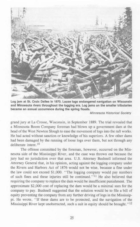
Log jam at St. Croix Dalles in 1870. Loose logs endangered navigation on Wisconsin and Minnesota rivers throughout the logging era. Log jams on the smaller tributaries became an annual occurrence during the spring floods.
Minnesota Historical Society
grand jury at La Crosse, Wisconsin, in September 1889. The trial revealed that a Minnesota Boom Company foreman had blown up a government dam at the head of the West Newton Slough to ease the movement of logs into the raft works. He had acted without sanction or knowledge of his superiors. A few other dams had been damaged by the running of loose logs over them, but not through any deliberate intent. 10
The offense committed by the foreman, however, occurred on the Minnesota side of the Mississippi River, and the case was thrown out because the jury had no jurisdiction over that area. U.S. Attorney Bushnell informed the Attorney General that, in his opinion, acting against the logging company under the Rivers and Harbors Act of 1876 would not be wise, because a fine under the law could not exceed $1,000. ''The logging company would pay numbers of such fines and these in juries still be continued.'' 11 He also believed that requiring the company to replace the dam would be insufficient punishment. The approximate $2,000 cost of replacing the dam would be a minimal sum for the company to pay . Bushnell suggested that the solution would be to file a bill of equity preventing the company from any further driving of logs in the Mississippi. He wrote, "If these dams are to be protected, and the navigation of the Mississippi River kept unobstructed, such a suit in equity should be brought. ••12
25

For Bushnell the real issue was the company's unlawful use of booms and loose logs in the Mississippi.
Upon receiving Bushnell's report, Attorney General Miller notified Secretary of War Redfield Proctor that the only course open was the filing of a bill of equity to stop the company's unlawful use of the river. Proctor requested a report from the District Engineer, and stated that if the report confirmed Bushnell's opinions, "I should then deem it advisable to take proper legal steps looking to the correction of the whole abuse." 13
At this point, a court injunction possibly would have improved river navigation below the Chippewa and above West Newton Slough by curtailing the Mississippi River Logging Company's driving of loose logs in that area. Major Mackenzie's opinion, however, changed all that. Mackenzie, whose office was in the same town as Weyerhaeuser's headquarters, blocked an injunction against the company. Despite the obstructions that the logs caused to navigation and to government projects, Mackenzie reported to the Attorney General and to the Secretary of War that he had no intention of combining the case of the blown-out dam with the rights of various classes of commerce on the upper Mississippi. He said that although the logging company's practices "caused delay and annoyance to other classes of navigation,'' conflicting navigational interests should settle their own problems without government involvement.14
Mackenzie felt that the company's destruction of the government dam should be punished under the Rivers and Harbors Act of 1876, but that the West Newton Slough case was not a sufficient cause to keep the Mississippi River Logging Company from moving loose logs in the upper Mississippi River. Mackenzie believed the company had already been chastised by having to appear in court, and that it would not want to antagonize the government further by repeating the offense. Furthermore, he had received a letter from Weyerhaeuser and his secretary, Thomas Irvine, in which they agreed to repair the dam if called on to do so, and they promised that no further damage would be permitted. Mackenzie did not want the Corps to become a ~egulatory agency. He felt that conflicts between businessmen over the use of the Mississippi should be settled privately or through litigation between the involved parties. In spite of Mackenzie's policy, the new Rivers and Harbors Act of 1890 gave the War Department the power to investigate and punish the Mississippi River Logging Company if its works harmed navigation. 15
During this period of litigation Weyerhaeuser sought congressional sanction of his company's log drives. In 1891 Representative Washburn of Minnesota introduced a bill in Congress that would have allowed the transport of loose logs on the Mississippi and the right to operate booms and other structures in the West Newton Slough and elsewhere. The bill passed the Senate, but a similar House bill was stopped, largely due to opposition from the Wisconsin legislature. 16
Undaunted, Weyerhaeuser's company continued to drive logs across the Mississippi under the provisions of the 1880 law. Although the company blatantly violated even that law, by 1892 no further federal action had been taken against the
26

Logs were collected at boom sites to be arranged Into huge rafts for further transport. This Is the St. Croix boom In 1886.
Minnesota Historical Society
Mississippi River Logging Company. In March of that year U.S. Attorney Bushnell introduced a resolution to Congress (in accordance with one adopted by the Wisconsin legislature) requesting information from the Attorney General and the Secretary of War concerning the destruction of government darns and obstructions to navigation between the mouth of the Chippewa and the West Newton Slough. The resolution called for proper action to stop these obstructions to navigation. The resolution passed, and the Chief of Engineer!> referred it to Major Mackenzie for investigation. 17
Mackenzie's report supported his previous policy. He noted that obstruction to navigation "will continue so long as the habit of running loose logs lD
the river is followed." He reported that the clogged river conditions bad brought different classes of commerce on the Mississippi into conflict. His major concern, however, was that sawmills depended on the Mississippi River Logging Company for their log supplies, and any interference with the company's operations would destroy a large part of Mississippi River commerce. Mackenzie repeated his belief that the question of the rights of different classes of commerce .should be settled in the courts by the parties whose interests were affected, rather than by the government. 18
The Rock Island Engineer was unwilling to recommend action that would prejudice the rights of any class of commerce. He advised that the case not be dropped entirely but held in abeyance in case the company violated its promises to leave government darns alone.l9
27
The Attorney General and the Secretary of War accepted Mackenzie's report and decided not to bring the issue to the attention of another grand jury. When the Corps' reluctance to regulate Logging practices became obvious, steamboat pilots and others filed suits against the Mississippi River Logging Company for damages caused by their loose logs and booms, and payments were made where damage was demonstrated. Yet many were angered by the accommodating attitude of the government and its lack of tough-minded action against the company's unlawful use of logs and booms on the Mississippi.20
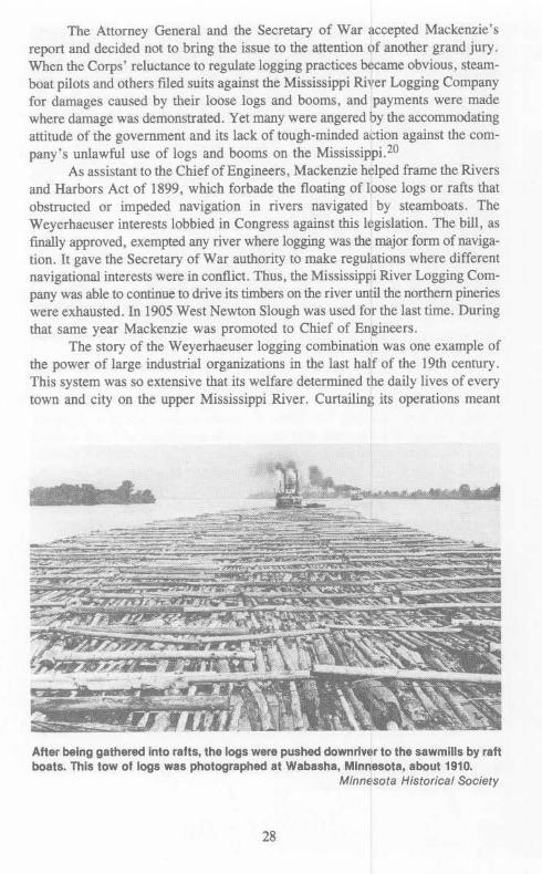
As assistant to the Chief of Engineers, Mackenzie helped frame the Rivers and Harbors Act of 1899, which forbade the floating of loose logs or rafts that obstructed or impeded navigation in rivers navigated by steamboats. The Weyerhaeuser interests lobbied in Congress against this legislation. The bill, as finally approved, exempted any river where logging was the major form of navigation. It gave the Secretary of War authority to make regulations where different navigational interests were in conflict. Thus, the Mississippi River Logging Company was able to continue to drive its timbers on the river until the northern pineries were exhausted. In 1905 West Newton Slough was used for the last time. During that same year Mackenzie was promoted to Chief of Engineers.
The story of the Weyerhaeuser logging combination was one example of the power of large industrial organizations in the last half of the 19th century. This system was so extensive that its welfare determined the daily lives of every town and city on the upper Mississippi River. Curtailing its operations meant
After being gathered Into rafts, the logs were pushed downriver to the sawmills by raft boats. This tow of logs was photographed at Wabasha, Minnesota, about 1910.
Minnesota Historical Society
28

that financial growth would be affected in all parts of the upper Midwest. Although a great portion of Wisconsin was concerned about the long-range effect of this syndicate on the environment of the Chippewa, Black, and St. Croix watersheds, the District Engineer's policy at Rock Island was to support the lumber monopoly in spite of loose logs in the main channel, illegal booms, and the tampering with government dams. Damages were to be paid to those abused. Mammon ruled on the tributaries, just as it had in the headwaters region.
29

IV
POLLUTED WATERS: ASSISTING COMMERCE
In the spring of 1882, Mark Twain began his famous trip up the Mississippi River. During his journey from St. Louis to Minneapolis he was amazed at the ''bristling great towns,'' the largest of which were Quincy, Keokuk, Muscatine, Winona, Moline, Rock Island, La Crosse, Burlington, Dubuque, and Davenportall of which had manufacturing foundations in the lumbering business. Twain described these cities as ''all comely, all well built, clean, orderly, pleasant to the eye and cheering to the spirit.'' 1 Never, even with his critical eye, did he say a discouraging word about the smelly, dingy, heavily polluted backwaters that plagued these communities ten years later.
Because of the vast urban growth of the two prior decades, practically all of the upper Mississippi River towns faced an unhealthful waterfront by the 1890s. Quincy, lllinois, was one of the cities Twain praised in i882 as "wholesome" with "broad, clean streets, trim, neat dwellings and lawns, fine mansions, stately blocks of commercial buildings ... ample fairgrounds, a well-kept park, and many attractive drives; library, reading rooms, a couple of colleges, some handsome and costly churches, and a grand courthouse, with grounds which occupy a square.' •2 When Tw~n visited the city of 30,000, it was because of a manufacturing center. The growth of sawmills, ice houses, railroad yards, and numerous factories helped to make this an important harbor on the Mississippi. After the Civil War, when Quincy was prospering, a fine current flowed through Quincy Bay during low-water stages. By 1890 the current ceased to flow when the water in the bay dropped to less than a five-foot depth. The problem was caused by physical "improvements." Cutoffs enabled Willow Slough to fill with sand, and the levees constructed by the Corps of Engineers reduced the current in the harbor. As a result the waterfront became stagnant and unnavigable during low water.3
The city of Quincy wanted the government to reopen Willow Slough or some other channel between the Mississippi and Quincy so that sewage and other deposits could be carried off in the continuous current that would be produced. In 1888 Quincy petitioned Congress for funds to improve and maintain Quincy Bay. City Engineer E.R. Chatten wrote to the mayor and city council of Quincy
31

~'L~_,··'"
rt/ ~-~~-..:;~~PS~:~L~~=Rot:~r::AYS•~:~:~·~:.~·:p~u:~~~A~u•cf~e
:J::;:, -:,;~~~7.;-: .. -:~:~~:;.~·:;;.~ ~·~v; ~~J!~i:,·;;~~\:: hisf!~r.
-a•P'•"idfti!Or6y.,r/.,.,~ncllulrll•"~'"or.MMrch 3.1.,!1.----M4! JQO~rr,;,-~ .... u,-~ c .• .Hc:D.::r"4_ .... _.,,4qe>.J
aiU'l ·~-'""~"",.,..,.,_.!!AU ~7"/'nr' .HprtL +. 1&99.
Quincy Bay and harbor, Quincy, Illinois. The harbor, once cleansed by currents from small tributaries, became stagnant after the cutoff of Willow Slough and the construction of levees.
National Archives
N ~

suggesting that a careful examination of the bay be undertaken. He proposed use of the harbor as a sewage outlet rather than looking for other methods of disposal. The Rivers and Harbors Act of 1890 authorized an examination of Quincy Bay and of the proposal to open a channel between the Mississippi and Quincy. 4
Many citizens of Quincy wanted the government to reopen one of these channels, but Major E.H. Ruffner's study concluded that this would not be wise. The expense of creating a channel that would permit navigation and allow the passage of enough water in the bay to move the accumulating deposits could not be justified by the ''interests of commerce.'' In addition, Ruffner reported that reopening Willow Slough or any other minor slough or channel would be against the river improvement practice of closing small channels to concentrate the passage of the river in the main low-water river channel. Instead, Ruffner recommended the continued dredging in the bay. 5
Two months later at a public meeting in Quincy, residents complained about the effects of the closed channels and levees. Most discussion centered on the need to bring more commerce to Quincy. The question of the city's health was largely ignored. One resident remarked, ''the sanitary condition of the water is of minor importance to a growing city. '' Some, however, noted that stagnant water in the harbor was endangering the lives of river and ice men who worked there. Thirty-nine Quincy residents petitioned the Board of Engineers for a channel sufficiently deep and wide to admit steamboats at all river stages and capable of supplying a current to carry accumulations out into the bay. 6
The Corps refused to reopen the Willow Slough channel. The Rivers and Harbors acts of 1890, 1894, and 1896 appropriated $65,000 for dredging and improving Quincy Bay for navigational purposes. The city of Quincy also asked for and received a harbor line at Quincy Bay in 1890 to halt factories in the bay from dumping refuse. The bay was diminishing in depth and area, and Board of Engineers officers hoped to reduce the accumulation of deposits from local sources by establishing protected harbor boundaries. 7
Clearly, 30 years of intense Corps activity in building closing dams, wing dams, and other structures necessary to provide a clear channel for commerce had a dilatory effect on the health of upper Mississippi River towns. Even a small village such as De Soto, Wisconsin, was plagued with a polluted river front. Because of its location on a backwater channel of the Mississippi about 30 miles south of La Crosse, the commerc~al interests of this harbor were deemed unworthy of the expense of dredging the large bar that reached from the shoreline to the river channel. Corps construction in the area slowed the current during low-water levels. Further difficulties arose when a new Corps dam prevented the river current from carrying away stagnant water even during normal river stages. Ten years later, and after many petitions for help from town officials, the new dam was demolished. 8
Corps policy regarding harbor pollution varied according to the size and importance of the locality affected. By 1880, the most important distribution port on the upper Mississippi between St. Louis and St. Paul was La Crosse, Wiscon-
33

tf
~~j:
'~~~\<<,·, . ,. ~~~~Zl;~ ,,
Willow Slough Is clearly visible on this 1890 map of the Mississippi River at Quincy made to accompany the government. report evaluating the reopening of the channel.
National Archives
;;t;

w VI
A y f'
0 N "$
F
g ~ "
~¥ c·t•>:a :mt'itJitJ~n·rx nrnm g.,.,, ST.P.4f:L to PFUJ'f KJ7.: L'fLA..">f)
"'"""'"''"P""'' ff•<j•'" "/·*<<j;>/;f#A-<.ONI>-."L '•·~•'>'/-?"""-""
dw '"'/"""' '"'0>( •o' f);• ,.,..,,.,. ,,.. Q,, ,.,,_rye
/'.'X'rb•.in: $-.. .. t .. ·~,..;;:.
..,_,,,,,.-...,,!> .-.--~ ¥'• &. ··~~.~ }t<!<o -;-,,,.,.. t '"'"~,.,..,. ;;:,. _,- "'f"'d :t.>JI"mH"""'
(,...;•< We"»»• •>f<" '>,ftP,.,..
-- •'t ~~fJ>..<:>kt-h"""'""__,
~P>:tJ,..¥"*~ #·-
li!'it ··~'""''"""'"'-"_" __ ,._, ... ,.. .• ~-""···"··
A4>""~<'l .... }N,I)',_.,;_., ---
!"'"';"'~'<~4·--~
"'~··•~·;y••~«w _.,__,--"~~·•·•
/,~AA~ ..,.,do#~¥" '''''"'"''""-"- ~· .--.<
·~-- ''M"' ;t>...x«l··-••»"
ah<et 1a. '
.• , ·"'· · r I !' •. ., • .,d,.~ lf...·~A "'.~ ~'-u 1
"i. }· '···f':~"
t:.:::w«i-"' !- 'k t '"~
This map of the Mississippi River from St. Paul to Pig's Eye Island illustrates the kinds of work the Corps did to maintain a com· mercial channel. Such Improvements, however, caused the water along the shore to become stagnant and polluted.
National Archives

sin. In 1890, La Crosse was the second largest city in Wisconsin and one of the nation's largest lumber centers. In that year, the city's sawmills manufactured 239 million feet of lumber, 54 million laths, and 121 million shingles.9 By 1896, more steamboats were owned and controlled by La Crosse businessmen than at any other port on the Mississippi. It was an important enough harbor for the Corps of Engineers to maintain a full-time office there. William A. Thompson became the Corps engineer at La Crosse.
La Crosse was strategically located at the mouth of the Black and La Crosse rivers on the eastern banks of the Mississippi. During the Civil War the La Crosse and Milwaukee Railroad was the primary carrier of grain from the Mississippi to eastern ports. After the war, the Chicago, Milwaukee, and St. Paul Railroad passed over the Mississippi at La Crosse, carrying supplies to settlers in Minnesota, Iowa, and other trans-Mississippi points and bringing back quantities of grain to be milled or distributed in La Crosse, Milwaukee, and other grain centers. 10 The harbor grew to accommodate this booming river traffic and by the 1880s possessed an extensive boatyard. It thus became a railroad as well as a steamboat terminal. Hemlock supplies in the Black River valley gave rise to an important tanning industry in La Crosse, and foundries and machine shops were established to provide steamboat repairs and sawmill machinery. The city also developed breweries, cigar factories, and related industries. 11
Until the 1880s, the heavily used harbor had extended 2,400 feet along the city's river front, and the eastern side of the Black River provided additional landing space. However, due to Corps improvements in the Mississippi channel, the harbor was gradually diminishing in length and becoming more difficult to navigate. Instead of joining the Black River and forming a current swift enough to carry away debris entering from the La Crosse River, the Mississippi channel now struck the eastern shore to the south of the Black and La Crosse rivers. The current of the Black River was insufficient to carry away the sand and mud deposits from the La Crosse River. By the early 1890s, a mud- and sandbar had grown so large that during low-water stages boats were unable to land in the Black River or in much of the La Crosse harbor. In addition, sewage dumped in the river at La Crosse was gradually accumulating in the harbor because of the changing river channel, creating offensive odors and unslightly and unhealthy conditions on the waterfront.12
The Corps had changed the channel of the La Crosse River in 1884. This alteration accelerated the buildup of deposits in the harbor. In addition, a bridge built across the Mississippi at Mt. Vernon Street had shortened the wharf. An eddy near the bridge made the departure of boats dangerous. Railroad tracks along the levee decreased the space available for handling freight. Docking of steamboats below the Mt. Vernon Street bridge became impossible because sawmills and other manufacturers occupied so much of the shoreline.I3
The La Crosse harbor clearly needed improvement; the encroaching mud, sand, and sewer deposits had become obstructive and at times even dangerous to navigation. The Rivers and Harbors Act of 1894 authorized the Corps of
36

w -.1
' i . '
--~-~,!. ;;,. ~
~~~ ~-""'7'-...\:.A C A 0 S S £ ·~N-:-.--.L_·"(~-:y~'"";.·_
~ ":':-~ ~- ., .. .._.. ,, ~
. ... - ¢,. It, • r •
,.iA.,. ..... c; ..,w filii .. •• •_.. . '1:.
"'"'~~-···~~..,.
A ..
~A • ¥Iii"''
fl;---·.<-t · W ; v f
o<', '•
40 _ .. :-. Q ~ I.$4,.._D
~ f A II#{O"'f/1.$4.44""0. I ,.Y •· ~ ..,.. .... ~ ~. '-."'
1,. ~ .-~....,....:~ ............... ..:....""',.,.. -~-..;.;.....(,.
. ·~ ....... ~~,~ ~-~ · ·.~/·-..-.:. .... '\W:..• y,.;r ~- ~ .---· •t~ . ~- ~-..- .. r"· ,...-~' ...
~- .. .,.4•~··· ·· ......
t" .......
i •' 'I
~ j"'J"~·.l ~ ; , ~t' · !~:::;:;-: · : l~~ ·,·l·~ lt
/ul/1~· t 'i' 111tl1 '•' I~. I I '.NI'J,\'.'11.: Ill"''
~n . . wu 1'I.T -~.:'
The channel Improvements on the Mississippi In the late 1870s also altered the condition of the harbor at La Crosse, Wisconsin. After the change In the channel, debris from the La Crosse River, shown at top center of the map, was no longer carried away by the current of the large riven; but settled In the stagnant harbor.
National Archives

Engineers to conduct a preliminary examination of the harbor. Major Mackenzie carried out this survey. Emphasizing the city's importance as a manufacturing and shipping center, he recommended that La Crosse receive government assistance. He also suggested a more extensive study of the harbor to determine all the factors involved in maintaining a navigable shipping terminal.I4
La Crosse's Board of Trade, whose objectives included the promotion of business and the encouragement of new manufacturing, was also concerned about the state of the city's harbor. The board's Committee on River Improvements supplied Wisconsin Representative Michael Griffm with "oratorical and documentary ammunition'' to gain funds for improving the La Crosse harbor. In January 1895 Griffin introduced a resolution to the House requesting an appropriation for improving the La Crosse harbor. Authorization came in the 1896 Rivers and Harbors Act for a government survey of the harbor. 15
The survey was conducted by Assistant Engineer Thompson of La Crosse, under the supervision of Lieutenant Colonel William R. King of Rock Island. The two proposed the construction of a brush and rock bulkhead, 1,575 feet long, stretching from the center of Main Street upriver to a point about 1,000 feet from the shore and nearly opposite the foot of Badger Street. A smaller cross dam, approximately 400 feet long, would be built shoreward from the upper end of the bulkhead to catch deposits from the La Crosse River. The Corps also agreed to dredge the bar to the west of the bulkhead and to deposit the material inside the bulkhead. They hoped the city would eventually fJ.ll in the rest of this space for use as a park.I6
The proposed harbor improvements would add approximately 800 feet of docking space to the 500 feet already available. However, King and Thompson recommended that no government expenditures be made until the city moved its sewers to a point outside ofthe government works to ensure that the river current would carry away sewage.
Delegates sent in January 1897 to the Washington River Improvement Convention made good use of their time calling on Wisconsin congressmen. They were assured that "a liberal appropriation to complete the work" would be passed. Congressman Michael Griffin was the most important advocate. The delegation met with Mackenzie, then in the Chief's office, who also endorsed their plan.l7 Chief of Engineers William Craighill and Secretary of War Daniels Lamont also approved the proposal. Congress appropriated $12,000 for improving the La Crosse harbor, providing that no federal funds be spent until La Crosse moved its sewer system outside of the proposed bulkhead. The Rivers and Harbors Act of 1896 had included an appropriation of $5,000 for the La Crosse harbor. Consequently, $17,000 was available to carry out the project. 18
A new policy was thus initiated. Local officials were responsible for local pollution. Such problems must be solved with local funds before federal improvements could be made. Nothing was said about pollution of the main channel or of downriver municipalities. La Crosse Mayor James McCord told Board of Trade members at an 1897 banquet that the city's sewer system was no longer
38

adequate. The anticipated extension would carry sewage from the business section to a point south of the intake pipe of the water works. Stating that ''care for the health of the city seems to make this a necessity,'' McCord noted that any government harbor work depended on the city's efforts to improve its sewage system. 19
River commerce and access were essential to La Crosse manufacturers, and the city agreed to make the required sewer changes. Because of a delay while the city sought the funds, no federal work was done in 1898 or 1899. La Crosse Mayor Wendell Anderson contacted the Rock Island Corps office on 15 November 1899, and requested that the Secretary of War be notified that ''conditions precedent to the expenditure of appropriations for completing the harbor work at La Crosse have been complied with." Harbor work began in 1900. The La Crosse Board of Trade expressed their appreciation to Assistant Engineer Thompson for conserving their river front, and lauded the members of the La Crosse Common Council as ''men of civic patriotism and progress'' for authorizing the necessary sewer changes. 20
Corps river policy in the 19th century concentrated on navigation and a clear channel for steamboats. Snagging trees, removing obstructions, closing secondary channels, and building hundreds of wing dams greatly aided commerce. The growth of commerce resulted in rapidly expanding urban communities. As these new cities developed manufacturing facilities, more refuse was dumped into municipal harbors. By the 1890s the growth of population and industry overburdened the capacity of the Mississippi to carry away urban wastes. Ironically, Corps improvements for commerce were partially responsible for the rapid growth of river towns. Lumbering and other industries, along with the rise in population, caused a health problem on the upper Mississippi River. If a locality had little commercial value, such as DeSoto, the Corps ignored the problem. In the case of Quincy, the Corps was willing to dredge the terminal and establish harbor lines to curb industrial pollution. An important city such as La Crosse, which could mount political pressure in Congress and in the Chief of Engineers' office, did obtain federal assistance. However, by the turn of the century, the federal government had begun to establish a policy that urban wastes were the responsibility of those municipalities that were dumping refuse into the Mississippi. The policy for sewage removal became: put it in the main channel. Mark Twain, who complained during his 1882 trip about "unholy" railroad trains "ripping the sacred solitude to rags and tatters'' and ruining the 800-mile shoreline along the placid river, would certainly have had a critical comment about the deposit of human and industrial wastes into water that he had compared to a woman with a clear and fine complexion.21 By the end of the 19th century the river was more important as a sewage conduit than it was as a navigational channel. The picturesque towns Twain observed had grown into industrial cities.
39
The upper and lower locks of the Falls of St. Anthony, 1976. St. Paul District
40

PART TWO: CREATING PUBLIC WORKS, 1900-1970
The steamboat dominated the upper Mississippi in the 19th century. First came the river packets and the glorious age of the stemwheelers. During the Civil War eastern railroad terminals along the river became centers for grain shipments. After the Civil War the north-south traffic on the river decreased, and the main channel was taken over by the lumber industry. By the end of the century, log transportation was recognized as a form of commercial navigation. During this period the Corps of Engineers concentrated on improving navigation and providing a clear channel for riverboats.
The 20th century witnessed a gradual change in this single-minded approach to river management. After the last log drives in 1905, the river ceased to be a major link in the nation's transportation system. Between 1905 and 1940 the Mississippi became a recreational resource. Excursion boats plied the water between scenic wonders, and hunting and fishing dominated the backwaters and sloughs of the upper Mississippi. As a result, a large section of the upper Mississippi was designated as a wildlife refuge.
During the 1930s a renewed interest in navigation spurred the building of a nine-foot channel and the construction of 26 locks and dams on the upper Mississippi River. Just as the Illinois and Mississippi Canal (Hennepin) that preceded it (1892-1911), the nine-foot channel was a public works solution to navigational needs. But, by the 1940s the Corps was involved in many waterrelated problems other than navigation. The Corps also focused on flood control, water supply, water quality, and recreational use of the Mississippi watershed. For the most part, the Corps dealt with these new concerns by constructing public works such as dams~ floodwalls, small boat harbors, diversion channels, public access roads, and recreational parks. Public works as the major design approach to water management began at the tum of the century and ended in the 1960s. The following five chapters describe some of the environmental changes that occurred during this phase of Corps history.
41

'V
RECREATIONAL WATERS: THE POLLUTED CHANNEL
During the past two decades the environmental movement won strong support in Wisconsin and Minnesota. The conservation of natural resources along the upper Mississippi, however, began in Iowa. The center of concern for the preservation of wildlife and scenic beauty along the river was the small town of McGregor, Iowa. McGregor, which is across the river from Prairie du Chien, Wisconsin, is located on a stretch of the Mississippi that has always been known for its outstanding scenic and recreational qualities. In the summer of 1919 McGregor became the home of the American School of Wild Life, out of which evolved the national support that eventually created the Upper Mississippi River Wildlife and Fish Refuge. This area, with approximately 300,000 acres set aside for recreational use, is one of the largest national tracts ofland providing a habitat for birds, animals, flowers, plants, and aquatic life. 1
A tradition of environmental conservation provided the background for this action. In 1876, under the direction ofFish Commissioner B. F. Shaw, Iowa began to rescue fish that had been trapped in the flooded backwaters of the Mississippi. The rescue mission was so successful that Missouri, lllinois, and Wisconsin soon established their own operations. By the 1920s about 150 million fish a year were being saved. One-half of this total was put back into the Mississippi and the rest was stocked in other lakes and streams.
Conservationists and sportsmen were not the only individuals interested in the backwater areas, however. Developers planned to reclaim the rich bottom lands to increase agricultural production. Senator William S. Kenyon and Representative Gilbert Haugen, both of Iowa, tried to stop floodplain development by planning a national park for the Iowa and Wisconsin sides of the river at McGregor. Congress voted against their proposal. National parks were carved from federal lands, not through the purchase of private property. The KenyonHaugen bill, which was introduced in 1916, 1917, 1921 , 1923, and 1924, never seriously challenged the established policy of national park development.
During this period, George Bennett of McGregor, a retired Episcopal minister, and Edgar R. Harlan, the Curator of the Iowa Department of History and Archives, formed the Wild Life School. They invited Iowa college professors
43

Part of the Upper Mississippi River Wildlife and Fish Refuge near Lansing, Iowa. St. Paul District
to lecture on botany, zoology, ornithology, entomology. geology, forestry. and other subjects related to the environmental development of the upper Mississippi watershed.2 Will H. Dilig, the president and co-founder of the Izaak Walton League, attended one of their conferences in 1923. Dilig formulated a plan to ask Congress for a wildlife refuge with the idea of later having the area declared a national park. He wished to block reclamation plans by creatmg a 250,000-federal-acre site that would prov1de a flyway for migrating waterfowl and ample water for the protection of the "native American" black bass.3 Dilig asked Congressman Harry B. Hawes of Missouri to introduce a refuge bill that would authorize $3 million for wetlands between Rock Island, lllinois, and Wabasha, Minnesota. The original draft forbade all public and private improvements in the area, including cultivation of crops. When the bill was referred to the Secretary of War for his opinion, he proposed that a new section be added with the following words:
44

Nothing in this act shall be construed as exempting any portion of the Mississippi River from the provisions of federal laws for the improvement, preservation, and protection of navigable waters, nor as authorizing any interference with the operations of the War Department in carrying out any project now or hereafter adopted for the improvement of said river.
The major interests of the Corps of Engineers were thus protected.4 Hearings on the refuge bill were conducted by Gilbert Haugen (R-Iowa),
who chaired the House Agriculture Committee. Many people interested in wildlife, conservation, fishing, hunting, and scenic beauty testified. Other towns along the river sent memorials to their congressmen. A resolution, for example, was sent from River Falls, Wisconsin, deploring the fact that Congress might adjourn before considering the refuge bill. On 7 June 1924, Congress authorized the Secretary of Agriculture to acquire land subject to overflow from Rock Island to Wabasha on either side of the Mississippi. Land could be purchased only with the approval of the appropriate state legislature. Congress set aside $1,500,000 for the purchase of the refuge lands, and placed a maximum price per acre at $5.5 Twice the Department of Agriculture asked Congress for additional funds and a higher price per acre to purchase the many different parcels of land. Each time the federal government was criticized for taking property to give rich sportsmen a paradise in which to hunt and fish. In spite of the wishes oflocallandowners and private sports clubs, Congress supplied the additional funds to develop anational wildlife refuge.
But the acquisition of land for wildlife was only part of the problem. The water that flowed through this property was the main sewer for most of the towns and villages along the upper Mississippi. Many citizens thought treating these wastes was unnecessary. Most theorized that the river would adequately purify any material dumped into it, a notion seriously challenged in the 1920s. Patrick Brunet's thesis discussed at least nine federal studies of pollution that were conducted between 1922 and 1934.6
The increasing amounts of industrial wastes were the most severe problem. Chief of Engineers Lansing Beach stated in 1924 that the ''theory of a stream purifying itself arose before the industrial development of the country had reached the point where it now stands, and when the material deposited in the streams was domestic waste." The dumping of oil into U.S. waterways particularly troubled many people, as oil was a potential fire hazard and destroyed fish and animallife.7 The legislation of 1899 failed to deal with the problem, because it was difficult to prove that oil would impede or obstruct navigation. The 1924 Oil Pollution Act prohibited the discharge of oil into coastal navigable waters. Yet the law prohibited dumping petroleum only from oil-burning or oil-carrying vessels; oil could still be emptied into the water from shorelines. Soon after the passage of the oil act, a bill was introduced in Congress to prevent oil pollution in nontidal navigable rivers and nonnavigable rivers, but it failed to pass. 8
The Oil Pollution Act of 1924 directed the Secretary of War to investigate all navigable waters and nonnavigable waters connected with navigable waters.
45

The Chief of Engineers asked each District Engineer to confer with local or state organizations and to compile a report concerning the pollution of the District's waterways. Major Charles F. Williams of the St. Paul District reported that river pollution in his District was insufficient to interfere with navigation, commerce, or fisheries. Williams' report was seriously challenged by sportsmen in Minnesota and Wisconsin, and local politicians asked Williams to clarify his position. Williams conceded that sewage dumped into the Mississippi River at Minneapolis and St. Paul was hazardous to fish life, but he believed that Lake Pepin, 30 miles downriver, was able to purify the sewage from the Twin Cities. 9
The outlet of the Starkey Street sewer Into the Mississippi River was one of many sources of pollution In the Twin Cities area In the 1930s.
Minnesota Historical Society
46

Major General Harry Taylor. Chief of Engineers, 1924-1926.
On 4 June 1926. Chief of Engineers Harry Taylor submitted the results of the Corps inveMigation to Secretary of War Dwight F. Dav1s. Taylor classified all polluting substances into two groups: domestic sewage and industrial wastes resulting from manufacturing processes. He stated that "except in the more sparsely settled regions, the navigable waterways of the United Stares and their principal unnavigable tributaries are polluted to a greater or less[er] degree by domestic sewage and/or industrial wastes. "tO However, he also believed that "except in isolated and unimportant instances the pollution of waters by domestic sewage and industrial wastes does not directly interfere with commerce or commercial navigation." II The Chief of Engineers reported that the pollution of the Mississippi was not serious enough to endanger or interfere with commerce. navigation, or fisheries, although Wisconsin and Minnesota were investigating the matter further.l2
Pleasure boating seemed to be the only form of navigation seriously affected by pollution. Boaters faced offensive odors in densely populated areas. Going
47

beyond navigational concerns, Taylor reported that in such areas or where industrial centers were located, water pollution was disastrous to fish life. He believed that the solution to the fish problem had to be determined by each community. Taylor's analysis relied on an economic value system: The income generated by the fish industry was usually small compared to the total value of products of all other industries using the waterways. Consequently, the damage to fish habitats was indicative of a technological society that placed greater values on jobs and products of industry. 13
Taylor believed that water pollution was not primarily a federal concern, and be advised the Secretary of War that state and local agencies were beginning to study water pollution and to take measures to control it. Some communities were experimenting with sewage treatment. Taylor recommended that the Oil Pollution Act be amended to prevent the discharge of oil from any source, instead of from vessels alone.l4
This photograph of Harriet Island In the Mississippi River at Minneapolis-St. Paul, c. 1911, shows the river at a very low stage.
Minnesota Historical Society
48

Reduced rainfall on the upper Mississippi River basin during the early 1920s depleted reservoir and groundwater storage. In the summer of 1925 the flow of the Mississippi through Minneapolis and St. Paul was insufficient to dilute suitably the sewage and industrial wastes. Many citizens complained to the Wisconsm and Minnesota state legislatures in 1925. Each legislature appointed an interim committee to study the river conditions in the Twin Cities area as well as on the St. Croix and Mississippi rivers along the Wisconsin-Minnesota boundary I me. A joint interim committee was later organized to make a separate study of the conditions of these waters. The group was funded by appropriations by the Wisconsin and Minnesota legislatures to the Minnesota Game and Fisb Commission and the Wisconsin Conservation Commission, and by additional funds appropnated by the city councils of St. Paul and Minneapolis. The U.S. Public Health Service furnished supplies, equipment, and supervisory aid.l5
The srudy concentrated on the effects of sewage and industrial wastes from Minneapolis and St. Paul. The investigation was conducted during 1926 and 1927. and covered approximately 137 miles of river from above Minneapolis to Winona. The study also investigated the possible effects of the dumping of sewage and
Harriet Island with the river at Its nonnal level, c. 1915. Minnesota Historical Society
49

industrial wastes from St. Paul and South St. Paul into a reservoir created by the building of a navigation dam near Hastings. Minnesota. As a result of a preliminary report submitted in January of 1927, the Minnesota legislature created the Metropolitan Drainage Commission of Minneapolis and St. Paul to investigate methods of treating Twin Cities sewage and to recommend ways of funding any necessary sewage construction. One year later, the committee submitted a second report to the state authorities. L6
This second report documented evidence of Twin Cities industrial wastes and sewage that could be found for 50 or more miles downriver; fish were totally absent in the river immediately below the Twin Cities. In addition, the Twin City Lock and Dam located 6 miles below St. Anthony Falls became a pool of foul water full of urban wastes for 5 miles upstream of the dam. This was a Corps dam built in 1917; it became a major source of power for a Ford Motor Company plant. All but one of the outlets of the Minneapolis sewer system and 11 of St. Paul's sewers discharged into the river above this dam. The problem was particularly acute during summer months when river discharge was low and water temperatures were high. Aquatic growth under these conditions captured most of the oxygen needed to purify the water _17
The Minnesota River joined the Mississippi a few miles below the darn, but it did little to relieve the polluted condition. Below this point additional sewage and industrial wastes from St. Paul, South St. Paul, and Newport were added
Twin City Lock and Dam No.1, also known as Lock and Dam No.1, the "high" dam, or the Ford dam, Is located six miles below the Falls of St. Anthony. In the late 1920s, sewage and Industrial wastes from both Minneapolis and St. Paul collected in the river above the dam.
Minnesota Historical Society
50

to the Mississippi. Thirty miles south of the Twin City Lock and Dam was Hastings, Minnesota, where the aforementioned lock and dam was under construction by the Corps of Engineers. The St. Paul District Corps office had investigated the possibility of increased stream pollution above this dam. District Engineer Williams reported that ''all of the cities and towns located on the Mississippi River from Minneapolis to Hastings now empty their untreated sewage into the Mississippi River." 18 Thus, the river already had a pollution problem that would increase with a new dam at Hastings. In spite of this obvious conclusion, Williams reported that the cities and commercial interests of the area believed that navigational improvements were of primary importance. He speculated that these towns and cities were prepared to take care of any problems that might arise due to the dam, including the building of public sewage treatment works.l9 Public works would solve both navigation and pollution problems.
The tone of the joint interim committee report was less optimistic. It stated that construction of a dam at Hastings would create a stagnant pool extending upstream all the way to the Twin City Lock and Dam. The report noted that although the relatively clear St. Croix River improved the condition of the Mississippi, pollution was still very evident in the next 30 miles downstream. At that point, the river entered Lake Pepin, which served as a settling basin. Much of the sewage that entered the lake settled on the bottom, and when the Mississippi left the lake, it was much cleaner. This was especially true when the water was high. During low water, the deposits in the bottom of Lake Pepin reduced the oxygen contents of the water, ''causing nuisances'' and serious fish losses. South of Lake Pepin the Mississippi again received large amounts of sewage, this time from Wabasha, Founta~n City, Winona, and La Crosse.20
In conclusion, the investigation revealed that from Minneapolis to the junction of the St. Croix River, the Mississippi was an unfit water supply source and was potentially dangerous to people and wildlife. ''Nuisances are frequent and fish life has been practically exterminated in this zone.'' While the Mississippi between the St. Croix and La Crosse was better, it was still unfit for use as a water supply source.21
The 1920s were a period when the recreational interests on the upper Mississippi began to form into political interest groups. These organizations of sportsmen and women pushed for the preservation of a fish and wildlife refuge on the most scenic portion of the upper Mississippi between La Crosse, Wisconsin, and Rock Island, Illinois. During this same period the increased transportation of petroleum aroused national concern over potentially damaging oil spills in navigable waters. The Corps was asked to complete a survey on oil pollution. When a part of this national study was completed on the upper Mississippi River, groups interested in fish and wildlife questioned the larger problem of pollution that came from municipal sewage deposits. Consequently, additional studies were made that showed the negative effects of domestic and industrial pollution on fish habitat. In 1928 the Corps began to build a dam at Hastings, Minnesota, the first in a series of dams that would enlarge the Mississippi River channel to
51

a nine-foot depth. The Hastings dam, which is downriver from Minneapolis and St. Paul, was studied for its effect on water quality. The study demonstrated once again that the environmental interests along the river were at odds with the commercial objectives of urban business groups, who wished to use the river to dump untreated sewage, as well as a route to increase the transport of goods. At the beginning of the decade, the American School of Wildlife at McGregor, Iowa, lobbied for preservation of river refuges; at the end of the decade, the same group formed a nucleus of opposition against the development of the nine-foot channel, which would be a focus of government action in the 1930s.
52

VI
COMMERCIAL WATERS: THE NINE-FOOT CHANNEL
In 1907, Congress authorized the Corps of Engineers to maintain a sixfoot channel on the Mississippi River from the Missouri River to St. Paul. By the 1920s, many people thought that the six-foot channel project was a mistake. Not only did the six-foot channel require constant dredging, but it could not accommodate the larger and heavier loaded boats. Barges that operated on the lower Mississippi had to be unloaded and reloaded at St. Louis or Cairo at a tremendous cost. As the volume of commercial traffic lessened on the upper Mississippi, there was a growing demand for a better navigation route that would allow the use of large tugs and tows to revive river transportation. One study showed that a nine-foot channel could carry 50 times as much tonnage as a six-foot one.l Actually, when the nine-foot channel was completed, the tonnage increased 120-fold between 1930 and 1974.
Supporters of a nine-foot upper Mississippi channel reasoned that therecent completion of the Panama Canal put the landlocked Midwest at a serious disadvantage compared to other sections of the country. The intercoastal rate through the Panama Canal was cheaper than the railroad rate from the Midwest to the coasts. As rail rates increased, strong support grew to restore pre-Panama Canal conditions by building a nine-foot channel. In 1925, the Interstate Commerce Commission increased rail rates from St. Paul to St. Louis from $. 63 to $1.25. Secretary of Commerce Herbert Hoover addressed this problem in a speech at Chicago in 1926. He calculated that since the Panama Canal had been built, New York was $2.24 closer to the Pacific coast while midwestern cities had moved $3.36 farther from western markets. 2
The 1927 Rivers and Harbors Act authorized a survey of the Mississippi between the Missouri River and Minneapolis, ''with a view of securing a channel depth of nine feet at low water with suitable widths." The project called for a number of locks and dams that would increase navigation on the upper river channel. 3 A similar project was already under construction on the Ohio River. The nine-foot channel project on the Ohio was authorized in 1910 and completed in October 1929. It was dedicated by President Herbert Hoover and viewed as a prototype project to test public investment in the growth and development of
53

commercial and industrial activity in the Ohio River valley. During the early 1930s the Ohio project failed to live up to expectations, but traffic gradually increased during the latter part of the decade.
Commercial interests along the Mississippi, including manufacturers, real estate developers, agricultural shippers, and others concerned with river transportation voiced regret over the lack of barge traffic. Some, however, thought that the great expense involved would be unjustified. Still others worried that the water in the reservoirs created by the locks and dams would become stagnant and polluted, harming fish and wildlife. The Upper Mississippi River Wildlife and Fish Refuge, authorized in 1924, owned most of the bottom lands between Lake Pepin and the Wisconsin River by 1930. In 1929 Henry B. Ward, president of the Izaak Walton League, expressed his concern to President Herbert Hoover and Major General Edgar Jadwin; Chief of Engineers, that the refuge would be destroyed by the nine-foot channel. 4
Major Charles L. Hall, District Engineer at Rock Island and a recognized opponent of the nine-foot channel, reported that the nine-foot channel was not economically feasible. In addition to documenting the lack of barge traffic on the upper Mississippi, Major Hall declared that the nine-foot channel project would greatly change the flora and fauna of the region, and the slackwater pools would create silting problems. Having addressed the Wild Life School at McGregor, Iowa, he was associated with that conservation group. Hall's concern with wildlife raised the ire of nine-foot channel promoters, some of whom felt that he was compromising his role as a government engineer. 5
The strongest supporters of the nine-foot channel came from the state of Minnesota. Wisconsin and Missouri congressmen were silent, but opposition came from Iowa, the home of the conservation movement on the upper Mississippi. Senator Henrik Shipstead of Minnesota carried the battle for the nine-foot channel through three administrations, ten sessions of Congress, and dozens of committee meetings. In March of 1929, Shipstead and Minnesota Senator Thomas 0. Schall presented Congress with a memorial from the Minnesota legislature. The document advocated the nine-foot channel project and asked for the dismissal of Major Hall, who ''has overridden the protests of the Mississippi Valley Shippers Association and of shippers generally throughout the Northwest, and has recommended to the Secretary of War in opposition to the establishment of a ninefoot channel on the upper Mississippi River.'' The memorial stressed the fact that increased railroad rates and the operation of the Panama Canal had in effect moved the Midwest farther from the seaboard. 6
In 1929 the preliminary report of the special Board of Engineers concerning the upper Mississippi was completed. The board reported that a nine-foot channel on the upper Mississippi River was feasible, and that ''reliable and economical navigation is not practicable on a depth of less than six feet but would be assured by a depth of nine feet.'' Additional support came from President Hoover, who reiterated his belief in water transportation. In a speech at Louisville
54

Major Charles L. Hall. Rock Island District Engineer, 1927-1930. Rock Island District
in 1929, he said that deeper shipping channels would put the nation's rivers back "as great arteries of commerce after half a century of paralysis.''7
Although the fmal survey report of the upper Mississippi was not sub mined to the Chief of Engineers until late in 1931, Senator Shipstead succeeded in putting an authorization for the nine-foot channel into the 1930 Rivers and Harbors Act. The bill, which passed on 3 July 1930, provided for an upper Mississippi channel depth of nine feet at low water, "with widths suitable for long-haul, commoncarrier service.'' Consequently, the upper Mississippi became a canalized river without the completed report on the project's economic and environmental ramifications.
The Corps of Engineers' fmal report noted many of the adverse effects of the nine-foot project. The most obvious environmental and economic changes involved the many municipal systems discharging sewage into the river. The Board of Engineers noted that the ''discharge of untreated sewage into the river now affects adversely the problem of general sanitation, and specifically, water supply,
55

the harvesting of ice, the use of the river for recreation and particularly for bathing and fish life at points where pollution is severe.' '8 Consequently, many remedial works would have to be built. Thte new reservoirs created by the 26 locks and dams threatened the water supply of many towns and cities along the main channel.
The Corps report incorporated the results of a Bureau of Fisheries survey of Lake Keokuk and other areas of the upper Mississippi. The Lake Keokuk survey determined changes in water quality and fish life after the nine-foot channel was completed. Major Hall provided a Corps of Engineers quarterboat for the Bureau of Fisheries during this investigation.
A large part of the survey centered on the physical, chemical, and biological conditions affecting fish in Lake Keokuk, where a dam built by the Hamilton Water Power Company was already in operation. The hydroelectric dam obstructed the movement of water, which resulted in a great deal of silting-in on the bottom of the lake and thus produced secondary changes. The team found a scarcity of plankton (the basic food for young fish) in Lake Keokuk, the result of closing sloughs and isolating the main channel. In many areas they found silt more than six feet deep on the lake bottom. The increased depth of the water and the silt bottom created a huge oxygen demand, especially as the silt contained sewage and other organic materials. Fauna found on the lake bottom was completely different from fauna found in nonsilted areas. It consisted of organisms tolerant of low-oxygen conditions, ''which have come to be regarded as indices of a polluted or biologically unfavorable body of water.' '9
The Bureau of Fisheries also inspected Lake Pepin and parts of the Upper Mississippi River Wildlife and Fish Refuge near Wabasha, where water levels would be raised by the nine-foot channel. There the erosion and silting-in problems were much the same as at Lake Keokuk. A sandbar impounding water in Lake Pepin produced water quality conditions similar to those in Lake Keokuk. However, both Lake Pepin and the Wabasha area included more backwaters and shallow shore water that produced plankton and supplied refuge for young fish.lO In conclusion, the Fisheries study stated that the construction of dams was not incompatible with fish interests so long as the fixed water-level type were used. The team recommended efforts to prevent the tremendous amount of silt and sewage from entering the river. An earlier study in 1922 by Professor Arthur Pearse, a University of Wisconsin biologist, reached the same conclusions. Pearse found that the decline in spoonbill and sturgeon in Lake Pepin could be attributed to "overfishing, the introduction of carp, the pollution of the river by industrial wastes, and the construction of t:llle dams. ••11
From the beginning of the work on the nine-foot channel, the Corps cooperated with other agencies and organizations to minimize the adverse effects of the dams. The project marked a turning point in Corps policy. At the request of ~oth the Bureau of Fisheries and the Bureau of Biological Survey, the Corps of Engineers modified the designs for the new dams to benefit fish and wildlife. For example, the pool above Lock and Dam No.6, a part of the Upper Mississippi Refuge, was planned to be maintained throughout the winter.
56

·.v..P DEPARTMENT ...
1- '•':~,:_,~ I
' ' ...
St. Jo~eph
N' I
~··~r::~'«> A Littlthlli
I
!ledahe •
GENERAL MAP UPPER MISSISSIPPI RIVER BASIN
SHO~ING
9-FOOT NAVIGATION PROJECT AND CONNECTING WATERWAYS
SC.,fr,L[ or MILtS u o n MJ ............
U.S.lt-IGIN[[PI Of'f'IC.[ U"Pll'l WISSIS$1PPI V.ti.LLtV DIVISION !loT. LOUIS, MIS!oOURt M.AIII(.H ?.0, lt)lli
i I c.,. (Jj7rdNU
.w+.----- ·-- --·C:7101erc~
COAPS OF [NGIN£fRS. U.S. ARM"f
I /
j ____ . . ~ ....
N 0.
...
This 1936 map of the nine-foot navigation project shows the location of the 26 locks and dams.
Actual construction on the new locks and dams began in 1930 and continued until 1935, using funds appropriated for the relief of the unemployed. Finally, the Rivers and Harbors Act of 1935 appropriated the entire sum required for the completion of the project, despite the opposition of individuals such as Representative Frederick Biermann of Iowa. He cited reports that a nine-foot channel was not economically feasible. Quoting from a Mississippi Valley Committee report of 1 October 1934, the congressman claimed that shippers would save
57

$7 million per year, while the project would cost the federal government $8 million per year. Biermann offered an amendment to the House to stop further expendirures on • 'the criminal folly called !he Upper Mississippi nine-foot channel.' ' 12
Every year from 1933 to 1936 Biermann introduced legislation to srop lhe ninefoot channel project.
Lock and Dam No. 3 at Red Wing, Minnesota, under construction. With a coffer dam protecting the site, workmen dig and set foundations lor the new structure.
Minnesota Historical Society
Part of the Corps plan was eliminated in the final construction. The original design called for a 140-mile extensiOn of the nine-foot channel to Brainerd, Minnesota. Congress approved this enlargement plan both in 1934 and 1937. however. in 1938 the War Department Civil Appropriations Act cut off all funds for extending the deeper channel into the northern hinterlands of Minneapolis and St. Paul. 13
The extension would have greatly changed the envirorunent of the upper Mississippi. The rich iron ore of northern Minnesota could have been barged into the Twin Cities, and a midwestern steel-producing center might have been established during World War ll.
By the mid-l930s the effec~ of the partiaUy completed project were evident, and most environmentalists were relieved. Fish were no longer stranded during times of rapid river fluctuation, and the deeper river depth attracted many forms of wildlife. Ira Gabrielson, then chairman of the Bureau of Biological Survey, observed !hat the federal darns near Winona stabilized water levels. upon which waterfowl depended. The dams. • 'which might easily have been designed to destroy most of the wildlife value of the area," acrually mcreased th1s value. Gabrielson felt that the waterfowl habitats created by the stabilized pools were a ·'concrete example of what advance consideration can do for wildlife in the planning of these major structures." Several years later Gabrielson wrote !hat the nine-foot channel project vastly improved !he wildlife refuge. although many
58

... Newly completed main lock at Lock and Dam No. 3.
Minnesota Historical Society
conservationists had assumed that the project would ruin the refuge. He praised the cooperation of the Corps, and declared that "it would have been impossible for any conservation organization, operating solely for the benefit of fish and wildlife, to stabilize water levels as effectively as had now been done." 14 Studies by Clarence F. Culler, H.R. Crohurst, and Max M. Ellis reinforced the opinions of Gabrielson. 15
Another major controversy centered on the actual operation of the loeb and dams. During the winter, after the navigation season ended, the Corps would drop the levels of the pools, sometimes as much as seven feet. This action allowed ice to pass through the locks and reduced damage to the gates. Conservationists and sportsmen opposed this drawdown policy, for it reduced wildlife habitats and increased the chances for winter fishkill. As a result, the Upper Mississippi River Conservation Committee was formed in 1943. The commission was made up of representatives from lllinois, Iowa, Missouri, Wisconsin, and Minnesota; and U.S. Fish and Wildlife officials.
The height of this controversy came during World Warn, when the Corps of Engineers argued that national defense and the need for shipping took precedence over all other concerns. After the war, the Corps halted the drawdown policy, but conservationists wished to establish a permanent policy of pool levels. The report of the Upper Mississippi River Conservation Committee cited the "deleterious effects" of the winter drawdown actions on fish and wildlife. The fight in Congress was led by August Andresen of Minnesota, who introduced a bill in 1946 to take pool level management out of Corps control. The bill was discussed by the House Merchant Marine and Fisheries Committee. a strong advocate of the Interior Department's concern with winter fishkill on the Mississippi River. Sportsmen also testified at the Senate Interstate and Foreign
59

Commerce hearings. In 1948 Congress passed the Andresen measure for a stable channel depth year-round between Rock Island and Minneapolis.16
During this period, the District office at St. Paul tried to accommodate the most vocal of the anti-drawdown advocates. In the spring of 1938, the Viroqua Rod and Gun Club sent a telegram to Lieutenant Colonel Phillip Fleming, St. Paul District Engineer, asking ''in interest of conservation of wildlife'' that the Lynxville dam be left open until 1 June. The club feared flooding would submerge and destroy hundreds of duck nests. After Fleming agreed to keep the gates open, the club promised to send him two "nice mallards" that fall. The next year the club notified Fleming that the Biological Survey had closed so much land to hunting that they had a hard time shooting ducks, and requested the maintenance of a ''decent'' level of water in the winter so the fish would not be stranded when the water was lowered. Fleming replied that although the canal was operated primarily in the interest of navigation, he was "extremely interested in other factors involved,'' and would try ''to operate the project for the benefit of them all, not inconsistent with the requirements of navigation.'' 17 Partially to accommodate these interests, the Corps gave 150,000 acres of overflow land to the Bureau of Biological Survey in 1939 for refuge use.
In 1939 Fleming lowered the shoreward tainter gate of Lock and Dam No. 9 in response to a request by W .E. Albert, Fisheries Supervisor of the Iowa State Conservation Commission. Albert had requested that the dam be lowered because concentrations of "bruised and injured fish" were stranded above the gate and unable to swim against the strong eddy. Earlier. in 1939, Fleming notified the Superintendent of Fisheries of the Wisconsin State Conservation Department that he regretted he was unable to lower pool No. 9 even one foot during February and March. Fleming explained that "variations in pool level are so strongly objected to by conservation interests that this office has decided to maintain the navigation pools in this District practically at normal operating levels throughout the entire year. "18
Abel Wolman, chairman of the U.S. Water Resources Committee, cited another political problem created by the 26 new pools of highly polluted water. In 1940 he wrote to Chief of Engineers Julian Schley about health-related matters on the new navigational channel. Wolman stated that malaria had been largely eliminated in the upper Mississippi valley during the past 50 years through drainage operations, but that the completion of the nine-foot channel might cause the return of that disease. Wolman also objected to the Corps policy of keeping water levels at depths to serve only navigational interests. He charged that this policy did not aid wildlife habitats.19
The Chief of Engineers asked his District Engineers to address Wolman's concerns. St. Louis District Engineer Colonel Roy Grower reported that the incidence of malaria had not been unusually high since the opening of Lock and Dam Nos. 24 through 26, except in one county bordering Lock and Dam No. 24. He doubted that the dam was responsible. Grower also reported that the pools in his District would not be drawn down during the nonnavigation season, and
60

(
Roller gates at Dam No. 15 are In place ae construction nears completion. Rock Island District
that "every effort will be made to cooperate fully with the fish and wildlife interests.'•20 District Engineer Colonel C.P. Gross of Rock Island reported that Wisconsin, Iowa, Minnesota, Missouri, and Illinois had initiated an "Interstate Malarial Survey" under the direction of the U.S. Public Health Service. He infonned Washington that the Keokuk pool had been operating for 27 years without any claim of malaria increase, and that the city and county health officer at Hannibal reported no material increase in malaria during the past few years. Gross also noted that wildlife interests might conflict with mosquito control. Using the mosquito-control techniques of the Tennessee Valley Authority meant the spread of paris green and copper arsenite as well as the lowering of the pool depth. This factor would certainly create a conflict, as "there may be 62 cases of malaria in Iowa from several causes, but there are at least 62,000 Izaak Walton Leaguers and their sympathizers who will yell about the dead fish and our stupid and hostile behavior if we raise and lower water levels, to say nothing of the cost to provide this extra foot for navigation in contrast with the cost of quinine." 21
In 1940, District Engineer John W. Moreland of the St. Paul office notified the Division Engineer of an investigation of mosquito-breeding conditions on the Mississippi between Wabasha and La Crosse by the State Boards of Health of Wisconsin and Minnesota. Moreland wrote that evidence indicated that most cases of malaria in Wisconsin and Minnesota were brought by outsiders, as this section of the country was at the extreme northern end of the malarial zone. He also reported that the operation of pools in his District had in general been satisfactory to fish and wildlife interests. 22
61

Chief of Engineers Schley informed Wolman of these findings and stressed that the Corps was cooperating with local representatives of the Fish and Wildlife Service. Wolman was still not satisfied. One month later he asked a St. Louis consultant, W. W. Horner, for his opinion. Horner replied that ''the Mississippi project was apparently working out far more importantly (sic) than even the wildlife services and enthusiasts had imagined.' •23
The conservationists were looking at long-range effects of the nine-foot channel project. The greatest short-range costs came from damages to sewer outlets and drainage and levee districts. For example, the filling of the pool above Lock and Dam No.5 flooded lowlands near the town of Cochrane, Wisconsin, resulting in many damp basements and an increase in sinusitis and rheumatism. Rock Island Engineer Colonel Earl Gesler recommended that the federal government rectify all damages caused by seepage and backwater from the Corps dams. Congressman Edward Eicher of Iowa sponsored the federal legislation. The Rivers and Harbors Act of 1937 provided for compensation to drainage and levee districts. As a result, remedial works were constructed at such river towns as Cochrane, Wisconsin. At times, the reservoirs were blamed for damages unrelated to their function. During 1938 dozens of property owners along the upper Mississippi complained of crop losses due to the slackwater pools of the newly completed dams. After an investigation, the Corps concluded that most of the flooding was caused by excessive rainfall. 24
Complaints were not the only response to the nine-foot channel, however. Shippers and barge lines were, of course, delighted. So were the large grain companies centered in the Twin Cities. Commendatory letters also came from sportsmen and conservation groups. D.H. Janzen of the Fish and Wildlife Service observed in 1941 that conditions for fur-bearing animals and waterfowl were unquestionably better since the completion of the nine-foot channel. Eldon Saeugling, superintendent of the Federal Fish Hatchery at Guttenberg, Iowa, claimed, that fishing was better since the construction of the canal, as did Ed Volkert, a commercial fisherman at Dubuque for more than 60 years. Perhaps the most significant comments were the remarks made at the 1941 annual Conference on State Parks by Ray Steele, superintendent of the Upper Mississippi River Wildlife and Fish Refuge:25
Many conservationists were alarmed and fearful of results when construction of the darns was proJJ>Osed; however, studies disclose material improvement of the water, and wildlife has responded to the new conditions quite satisfactorily. We are impressed with the fact that in this instance a navigation construction project has, in fact, been of tremendous benefit to wildlife.
The main objective of the nine-foot channel was to increase the naviga-tional use of the upper Mississippi River. No doubt this objective was achieved. During the 1920s the channel was used only to carry sand and gravel on short runs between sources of supply and local towns and cities. By the 1970s more than 60 million tons of bulk commodities were shipped on the upper Mississippi. This segment of the river was li11Ned with the rest of the nation's inland water
62

transportation network. The effect on the environment of the upper Mississippi was a mixed blessing. Cities and towns were forced to build treatment plants. thus improving the quality of the water. At the same time, silting behind the dams remained a problem. Constant dredging was needed. Fish and wildlife habitats were improved, especially after the Corps was forced to terminate its drawdown policy. Just as these problems were being addressed, renewed commercial activity put greater demands on river transportation. Tows and barges grew in size, terminals were enlarged, and the 26Iocks and darns became outmoded. Shipperl> began to push for a 12-foot channel to accommodate the increase in commercial development.
lock and Dam No. 21 at Quincy, Illinois, showing the locks, talnter and roller gates, spillway, and levee. A barge tow squeezes through the lock In the foreground.
Rock Island District
63

VII
DEEPER WATERS: THE TWELVE-FOOT CHANNEL
Since the completion of the 26 locks and dams on the upper Mississippi River, the Corps of Engineers has attempted to maintain a minimum channel depth of nine feet from Cairo to the Twin Cities. A congressional resolution adopted in 1945 authorized the Corps to undertake a study of the economic and environmental feasibility of deepening the lllinois Waterway and the Mississippi River from Cairo to Grafton to a minimum of 12 feet. A second resolution, adopted in 1945, authorized the Corps to investigate the stretch of the Mississippi from Grafton to Minneapolis. In 1949 the Corps completed the first twelve-foot channel survey. The Korean War delayed congressional action on this study. 1
Congress authorized the Corps to make a new study of the twelve-foot channel in 1968. The deepening of the lower Mississippi River to 12 feet was already under way. Barge lines asked for a uniform depth on the inland waterway system. The upper Mississippi water network was out of phase with other major segments of the Mississippi River and its tributaries. Minnesota businessmen began to worry about the economic consequences of a channel that would not accommodate new and larger tows. The Corps' North Central and Lower Mississippi Valley divisions, with the assistance of interested federal, state, and local groups and agencies, initiated a Phase I study in 1968. At meetings held the previous year in Minneapolis, St. Louis, and Dubuque, railroad interests objected to a deeper channel. Conservation and recreation interests also opposed any public works that would increase traffic on the river. 2 Engineers agreed that a twelve-foot depth could be achieved by either raising the height of the dams or by dredging the river bottom, or by a combination of these two methods. At a meeting held in Rock Island in 1968, Rock Island District Engineer Colonel Walter C. Gelini presented four alternatives for channel development: three feet of dredging; two feet of dredging and one foot of raise; two feet of raise and one of dredging; or three feet of raise over current water levels. A Missouri game official offered a fifth alternative: ''no twelve-foot channel.'' Colonel Gelini replied, ''the twelvefoot channel is here-today or tomorrow. ••3
The question of a twelve-foot channel, however, was not so simple. The depth soon became a major public issue. Fish, wildlife, and recreation interests;
65

railroads and truck lines spoke out against the idea. The widely publicized comment of one cttizen was that deepening the upper Mississippi would mean overflowing wetlands essential for the survival of waterfowl and flora and fauna, would necessitate constructing higher levees and dikes, and would possibly contribute to flooding. Calvin Fremling, a biology professor at Winona State College, claimed that although the filling in of the riverbed with sand was a natural process, the locks and dams constructed in the 1930s hastened the change. These dams caused sand to accumulate, making the riverbed rise and thereby raising the water level of the river. This. Fremling believed, me.ant more severe floods due to higher nver crests.4
Twelve-foot channel opponents also stated that dredging would harm the river bonom and would require additional material disposal sites to the jeopardy of fish and wildlife habitats and aesthetic values. A preliminary study of a 32-mile stretch of river in the pool above Cap au Gris, Missouri, revealed that the Corps had to dredge 740,000 cubic yards of sand and silt each year to maintain a ninefoot channel. For a rwelve-foot channel, the Corp:. estimated that 1,330,000 cubic yards would need to be dredged there. 5
The dredge Will1am A. Thompson, 1968. Boats such as this dig or pump out material from the river bottom to deepen the channel.
St. Paul District
Twelve-foot channel proponents maintained that a deeper channel would result in lower transportation costs and lower consumer costs for commodities. Spokesmen from grain, coal, and other industries claimed that the nine-foot channel was not competitive for upper Midwest farmers and manufacturers. Dean K. Johnson, Executive Secretary of the Upper Mississippi Waterway Association, said that each additional six inches of a barge's draft would permit a barge to ship an additional 110 tons of cargo at almost no extra cost. Because the lower Mississippi was 12 feet deep, shipments between the lower and upper river entailed the use of Jess efficient barges and the need to reload barges. The Upper
66

Mississippi Waterway Association strongly favored an expanded channel. They favored bigger tows and a reduction in locking time for their barges. 6
Mack Dixon, project mamager at the Corps' North Central Division, pointed out that a twelve-foot channel would not require deepening the entire river between Cairo and the Twin Cities. Some existing pools were already 12 feet deep. He estimated that approximately 20 to 25 percent of each pool's length needed attention. Opponents of the twelve-foot channel were not convinced. They stressed that the adverse effects of increased dredging or higher water levels would not be known until after the project was completed. Instead, they asked for further study of the present nine-foot channel.7
By 1972 the controversy was at its height. The Minnesota-Wisconsin Boundary Area Commission and Minnesota's representative on the Great Lakes Basin Committee asked for a federal study of alternatives to the proposed twelvefoot channel. Senator Gaylord Nelson of Wisconsin presented a public works bill amendment that limited further study on the twelve-foot channel to the investigation of environmental hazards and the completion of Phase I of the survey. The Izaak Walton League of Amerka and the Upper Mississippi Conservation Committee spoke out against the deeper channel. Barge line operators and commercial users of the upper Mississippi were just as vocal in stressing the benefits of the twelve-foot channel. Dean Johnson noted that even without a twelve-foot channel, the volume of goods shipped on the upper Mississippi would increase from the present 50 million tons a year to 225 million tons by the year 2020. A deeper channel would permit barges to increase each load from 1,300 to 1 ,600 tons. 8
The release of the broad-based Upper Mississippi River Comprehensive Basin Study in 1972 greatly alarmed twelve-foot channel opponents. The navigation appendix of the study, prepared by the North Central Division, argued that ''increases in lock size and increases in channel depths from nine to twelve feet on the Upper Mississippi River and the lllinois Waterways System is recognized as a distinct need.'' The report noted that commercial traffic between Cairo and Minneapolis had increased so rapidly over the previous 20 years that future traffic needs would ''require new, larger and more efficient locks and improved channels with navigation depths of twelve feet ... and possibly fifteen feet for the long-term 2020 needs." For many, this report confirmed suspicions that the Corps' current efforts to replace Lock and Dam No. 26 with a larger lock was the first step toward developing a twelve- or even a fifteen-foot channel. The orginiallocks on the upper Mississippi were 110 feet by 600 feet, and many were structurally sound. The navigation appendix of the Comprehensive Basin Study stated that eventually these smaller locks would be uneconomical and inadequate.
Reports in other appendices of the study revealed serious concerns about the twelve-foot channel. Most critical was the Fish and Wildlife Sevice's report that a twelve-foot channel wo111ld cause substantial changes in river ecology.9 The report pleased those opposed to the twelve-foot channel and disappointed
67

leased in fmal draft in September of 1972 (and in completed form in May of 1973). The study determined that nine-foot channel improvements and regulating procedures had resulted in a progressive loss of aquatic habitat for fish and waterfowl in some areas and an increase in the amount of "accreted" land. Even though the original locks and dams created a much larger wildlife habitat, dredging maintenance and natural sedimentation in the reservoir pools had led to degradation and deterioration of the habitat quality since the 1930s. The report expressed concern that if a twelve-foot channel were constructed such adverse conditions might develop at an accelerated rate. A twelve-foot channel would require increased dredging and additional locks.
The most important decision in the Phase I report was that a twelve-foot channel from Grafton to the Twin Cities would not be economically feasible. The Illinois Waterway from Cairo to Chicago was determined to be feasible, however. The report concluded by recommending that the twelve-foot channel study continue through Phase II, but that all studies of the area above Grafton should end. Further studies of a twelve-foot channel from Cairo to Grafton and on to Chicago have been deferred indefinitely due to the "unresolved conflicts" among environmental, navigational, and railroad interests.IO
The environmental effects of dredging and silt disposal figured in the rejection of the twelve-foot channel on the upper Mississippi. Dredging involves pumping or digging materials from the river bottom. Finding an adequate site within reach of the pipes is difficult. Dredging can damage organisms on the river bottom and disposal of dredged materials can cause many adverse environmental effects. Most of the dredged material from the upper Mississippi is a nontoxic sand, which has washed into the main channel from tributary sources. The material in some cases has been stockpiled by river municipalities for use in sanding icy streets, or has been placed on beaches in recreational areas to improve swimming and sun-bathing and to restore eroded shorelines. In the past, the Corps disposed of materials pumped from the upper Mississippi in the most economical method; in open water, on wetlands, or on shoreland near the dredge site. By the 1960s environmentalists claimed that the closing off of backwaters destroyed wetlands essential to many forms of fish and wildlife. If not properly managed, dredging could also spread contaminants, reduce biological productivity, bury shoreline vegetation, and increase turbidity. Disposal sites often destroyed scenic and recreational areas. In addition, dredged material frequently ended up back in the channel, especially after floods. II
Some nine million cubic yards of sand and silt were pumped annually from the upper Mississippi in the 1960s. The 1969 National Environmental Policy Act (NEP A) required all federal agencies to prepare an environmental impact statement (EIS) for any major federal action that would significantly affect the quality of the human environment. Whether the Corps' maintenance dredging operations were included was unclear. Late in 1969, members of conservation agencies in Iowa, illinois, Missouri, Wisconsin, and Minnesota; the Bureau of Sport Fisheries and Wildlife; and the Corps of Engineers undertook a survey of the Mississippi
68

Dredging operations In the Mississippi River. Mud and sand from the river bottom are being pumped to an area on shore. Barges await transport on opposite bank.
St. Paul District
from Cairo, Ulinois, to Hastings, Minnesota, to determine both the beneficial and adverse effects of the Corps' current dredging and disposal operations. They also investigated alternative uses of dredged material. The group's conclusion was that disposal practices were especially harmful whenever they led to the filling in of side channels, sloughs, and backwaters. These areas were extremely important to wildlife and their closure reduced suitable habitats. The team recommended a halt to disposal practices that contributed to this occurrence. 12
In 1972 Federal Water Pollution Control Act amendments required that the Environmental Protection Agency, along with the Secretary of the Army, establish guidelines and criteria for dredged material disposal. The amendments gave the EPA the power to decide where spoil could be placed. While these guidelines were being defined, the Corps was sued over the issue. In June 1973 the state of Wisconsin asked the U.S. District Court for an injunction to keep the Corps from disposing of spoil near La Crosse. At that point dredged material was washing into a slough and threatening a fish spawning area. The state said that the Corps had not filed an EIS as required by the NEPA, and was therefore violating federal law. 13
U.S. District Judge James Doyle issued a temporary injunction against the Corps. Soon after, he removed it stating that Wisconsin had not proved enough
69

damage. After gathering additional evidence, the state attorney general asked Judge Doyle for a second injunction forbidding the Corps to perform dredging operations in Wisconsin. The state cited the environmental damage in placing spoil where it could reenter the river or enter backwaters and destroy habitats. The Corps admitted that its choice of disposal sites along the upper Mississippi violated NEPA requirements. The EIS had not been filed because the Corps considered its dredging operations as regular maintenance work instead of as a new project. Furthermore, the Corps stated that if the court granted an injunction and stopped the dredging, commercial navigation on the upper Mississippi might be halted until the EIS was given final approval. Commercial users of the upper Mississippi rallied against Wisconsin's action. The Wisconsin Department of Natural Resources explained that the state was not trying to hamper navigation but was concerned with long-term effects of dredging operations.14
In March 1974, Judge Doyle granted an injunction, noting that spoil disposal in Wisconsin violated laws and caused significant environmental 'deterioration. The Corps was required to file an EIS on its upper Mississippi River maintenance proc~dures before it could deposit dredged materials in Wisconsin. The Corps filed the EIS and the injunction was lifted in April. Later, the Corps announced the policy that no new maintenance dredging would be done after 1975 until an EIS was submitted. 15 While the injunction was in effect, however, the Corps was required to inform the court of any emergency dredging necessary for navigation. Under these rules the normal dredging depth of 13 feet was lowered by 1 to 2 feet, and the Corps acknowledged that commercial navigation was not impaired.
The EIS revealed that dredging and disposal operations had caused significant damage to backwaters and marshland. The statement suggested several alternatives to the existing operation and maintenance program. As a result, the Corps began selective placement disposal.l6
Little time had passed befon:e the Corps was the object of another lawsuit. The state of Minnesota brought legal action against the Corps of Engineers in March of 1975, claiming that the Corps had violated state regulations. These regulations required the secondary treatment of spoil; forbade the discharge of spoil into navigable waters, and required dredgers to obtain a permit from the state. The Corps believed that it was exempt from Minnesota's water quality standards. The Minnesota position was that the Corps had to meet their regulations just like anyone else. Both the Corps and Minnesota claimed they were responsible for regulating dredged materials placement under different sections of the 1972 Federal Water Pollution Control Act amendments. Section 402 authorized states to establish permit programs to regulate the discharge of pollutants into navigable waters. Dredge spoil is defined as a pollutant under state and federal law. Section 404 gave the Corps the authority to issue permits for spoil disposal at specified sites. The District Court ruled in favor of Minnesota in October 1975 on the grounds that section 404 applied only if a state had no approved permit program or if its permit program did not regulate dredging. The court also ruled
70

Stockpiling dredged material In St. Paul, Minnesota, for future use as till for recrea· tiona I or Industrial land, for creation of marshes, or even for sanding Icy city streets.
St. Paul District
that requiring the Corps to follow state regulations would not impair its authority to maintain navigation. The Corps appealed this decision in June 1976, and four months later the U.S. Circuit Court of Appeals reversed the District Court decision. I? For some this case appeared to be more of a power struggle than an environmental issue. It did reverse a 100-year policy of close cooperation between the Corps office in St. Paul and Minnesota politicians.
As a result of the Wisconsin and Minnesota lawsuits, the Clean Water Act of 1977 included a condition (section 404t) requiring all federal agencies to comply with state or interstate regulations controlling the disposal of dredge or fill materials. Thus, state regulations control the final selection of sites and the type of placement, and states bear a major responsibility in the control of water pollution. 18
With the new legislation and court decisions, the Corps' cost for maintaining the nine-foot channel increased substantially. New methods of operation demanded larger crews and more equipment. In an attempt to adjust to these new conditions, the Corps sought help from the Waterways Experiment Station at Vicksburg, Mississippi. The Dredged Materials Research Program (DMRP), a $30-million, five-year comprehensive research project was developed to determine the characteristics of dredge spoil, alternative methods for its disposal, and potential uses for dredged materials. Possible uses included the creation of marshes and wildlife habitats, and the filling in of recreational or industrial lands. Experts
71

from science, government, industry, and academia recommended future dredging projects to the Corps in 1978.19
The Great River Environmental Action Team (GREAT), established in 1974 under the direction of the Upper Mississippi River Basin Commission, was an even more ambitious undertaking. This federal-state task force was organized to develop a long-range management strategy for the multi-purpose use of the upper Mississippi. Several federal and state agencies cooperated to develop the best possible river resource management. The entire stretch of the upper Mississippi from the Twin Cities to Cairo is under study. 20
Dredging and dredge disposal were considered tn both the GREAT and DMRP studies, and their findings changed Corps policy. One important result was that the Corps began reduced-depth dredging in 1975. Instead of dredging the upper Mississippi to 13 feet (to compensate for subsequent shoaling and channel filling), the Corps began to dredge to just 11 or 12 feet in some areas of the channel. Reduced-depth dredging cut dredging quanuties in the first four years of the experiment by approximately 35 percent. Because of restraints on funding and equipment. the Corps now chooses placement sites very carefully. evaluating each site prior to disposal. Except in an emergency, the Corps obtains permission from state agencies before placing dredged material, if required by state law. The Corps monitors water quality, and is searching for beneficial and economical alternative uses for dredged spoil, such as for sand beaches and wildlife habitats.21
The twelve-fOOt channel studies and the environmental movement of lhe 1960s modified significantly the public works policy of the Corps. By the end of the 1970s journalists were reporting that the Corps had "shifted gears'' and was one of the federal agencies taking seriously the need for public involvement in decision making.22 But the concern with navigation on the main channel of the Mississippi was not the only focus of Corps water resource management after World War IT. Flood control projects were the biggest addition to Corps responsibility.
~ ·--~ A recreational beach created with dredged material.
72

VIII
RUNAWAY WATERS: THE FLOODED CHANNEL
Since 1950, the St. Paul District Corps of Engineers has undertaken a large number of new flood control projects. The public has strongly supported some of these projects while others have resulted in controversial court fights. This chapter describes three major flood control projects: the industrial floodplain at St. Paul, the La Farge dam on tl!le Kickapoo River, and the relocation at Prairie du Chien.
The urban flood control project at St. Paul is among the most successful public works improvements on the upper Mississippi. One of the principal industrial areas of St. Paul is located on a floodplain just south of the business section. To protect this vulnerable area of the city from flooding by the Mississippi, the 1958 Flood Control Act authorized the construction of a flood control project along the west bank of the river. Levees, floodwalls, and interior-drainage facilities were designed for St. Paul. At South St. Paul the existing flood barrier was to be raised and extended, with additional facilities for interior-drainage provided. The worst flood on record in the area had occurred in 1952, and the improvements were to protect against a peak flood discharge of 168,000 cubic feet per second, well in excess of the 1952 reading. 1 The project was designed to do more than protect existing property. The city of St. Paul wanted to create a new industrial park on this flo~plain.
The St. Paul Port Authority purchased all of the property east of Robert Street to provide land for the 315~acre "Riverview" Industrial Park. The St. Paul Housing and Redevelopment Authority made similar improvements in the project area on the west side of Robert Street. Altogether, the flood barrier was built to extend approximately three miles. It was an earth levee with one-half mile of concrete floodwall. The flood barrier at South St. Paul added approximately 2.5 miles of flood barrier. The Corps completed the project in 1964.2
One year later a disastrous and record-setting flood hit St. Paul. The Mississippi crested at 171,000 cubic feet per second (cfs), 3,000 cfs over the project's design limits and 12 feet above flood stage. However, the levees, floodwalls, and a three-foot free board contained the flood, although extensive seepage occurred on the left bank of the river opposite the flood control project. The Corps'
73

Aoodlng of the St. Paul industrial floodplain In 1965. Levees are visible at the water's edge. Note supports for new bridge at far right center.
St. Paul District
The St. Paul Industrial floodplain In 1981. The "new" bridge is at far right. The levees and floodwalls are visible along the river.
St. Paul District
74

project was credited with preventing approximately $10 million in damages to the industrial area on the right bank of the river. The city's emergency levees built during the flood prevented another $7.8 million in destruction. After the 1965 flood, the Corps made new additions to the South St. Paul project, thus providing a barrier approximately two feet higher than the St. Paul project. Another massive flood, which reached 156,000 cfs, occurred in 1969. This time the flood control project prevented an estimated $15 million in damages. 3
The industrial and commercial development of the protected area accelerated after completion of the flood control project. By 1978 the project protected new investments of more than $41 million. The new industrial plants in the protected area employed more than 3,000 people and paid yearly taxes in excess of $1 million. Despite the acknowledged success of the flood barrier, as a result of the severe flooding in 1965 and 1969 and the rapid development of the protected area, the city asked the Corps to reevaluate the project. St. Paul wished to increase the flood walls to the same level as the Corps built in South St. Paul. 4
The St. Paul District's preliminary study in 1978 developed three alternatives for more investigation: (1) no action, (2) flood insurance and floodplain regulation, and (3) raising the flood barrier. The study recommended further research to determine the environmental effects of the alternatives. The involved area has more than a one percent chance of being flooded; consequently, concern remains about possible development of the remaining land in the former floodplain. The St. Paul District is authorized to review the project, and further studies are pending.5 The Corps project, however, has contributed to the industrial growth of St. Paul and South St. Paul.
A much more controversial flood control project was started by the Corps in the Kickapoo River valley. The Kickapoo is a tributary of the Wisconsin River in southwest Wisconsin. Nine communities with populations of 100 to 700 are located along the river. Portions of these villages have been inundated periodically by recurring floods, along with thousands of acres of croplands. The Corps first studied the valley's flood problems in the 1930s, but it was not until 1962 that the Corps submitted its final report. The document recommended the construction of a ''multiple purpose reservoir above La Farge for flood control, fish and wildlife conservation, general recreation, and a reduction in the deposition of sediment in the main channel and the floodplain downstream from the reservoir.'' Levees and channel improvements at two downriver communities were also included in the plan. Corps recommendations were approved by all federal, state, and local interests, and the 1962 Flood Control Act authorized the project. Funds for preliminary drawings were appropriated in 1964, and land acquisition began four years later. 6
The original plan provided for a dam 70 feet high, creating an 800-acre lake at a cost of about $12 million. However, in 1967 the Corps announced an expanded project that included a dam approximately 4,000 feet long and 100 feet high, providing a 33,000 acre-feet recreation lake with an additional flood control storage capacity of91,000 acre-feet. About 8,000 acres ofland were required
75

The La Farge lake and dam under construction In June 1973. The Corps stopped con· structlon In April1975 because of opposition from environmental groups and Wiscon· sin state officials.
St. Paul District
the reservoir would ''not deliver the recreational, economic, and flood control benefits I believed, and most citizens believed, existed in 1971. ''10
The Corps stopped all work on the project in April 1975. The dam and lake were approximately 36 percent complete at that time, and 90 percent of the land acquisitions had been made. Approximately $14.8 million had gone into the project. To most Kickapoo valley residents, the construction halt was tragic; they felt that they needed flood protection as early as possible and hoped that increased tourism would help boost the incomes of one of the most depressed areas in the state. Yet opponents of the dam felt that the Corps had overstated the recreational benefits of the project, had ignored the water quality problems, and had failed to prove that the tributaries below the La Farge dam would not continue to flood downstream communities.ll When the Corps proposed a four-month study of the dry dam proposal. the Sierra Club, Senator Nelson, and many others opposed the idea, asking instead for an in-depth study of all alternatives.12
Even though Wisconsin Senator William Proxmire bad supponed the La Farge dam project, in 1975 he also asked for a halt to construction because of its ever-increasing costs. This was a crucial point in the La Farge controversy, as Proxmire was a member of the Senate Public Works Appropriations Committee. Tbe residents of La Farge made an effigy of Proxm.ire and conducted a mock funeral service in response to Prox.mire's change of mind. Proxmire also opposed creating a national park out of the acquired project land, which was one of Senator
77

Nelson's suggestions. Proxmire joined some area residents who wished to put the land back on the tax rolls if it was not going to provide economic growth.13
Congress voted down construction funds for La Farge in 1976. In January 1976 a Wisconsin congressional delegation asked the Corps to review flood control alternatives for the Kickapoo. The Corps contracted with the URS Corporation of New York City to do the study. The URS report concluded that the dam would be marginally justified economically; it would create local economic growth but also an algae-choked lake. Their report concluded that a dry dam would provide minimal recreational benefits and major environmental problems. As a result of these findings, the Corps offered to modify its plans by creating a reservoir one-half the previously planned size. Governor Lucey responded to District Engineer Forrest T. Gay III that "an impoundment in the Kickapoo valley, whatever the elevation of the pool, presents a number of problems, including its highly eutrophic nature and the loss of important natural features.'' After a review of water resource projects in 1977, President Carter recommended to Congress that the La Farge dam be abandoned and that communities in the valley should receive assistance in developing nonstructural flood control measures.I4
Carter reiterated his opposition to the dam project in 1979 when the new Wisconsin governor, LeeS. Dreyfus, renewed efforts to build a dry dam. Dreyfus believed that without the dam, the Kickapoo valley would become a ''Wisconsin Appalachia.'' Several former landowners in the project area formed a group, called KLOUTS (Kickapoo Land Owners United Together), to work for the return of their land. They opposed creating a park and argued that the acquisition of their land had been for only a dam and lake. With the project abandoned by Congress, they wanted all land returned to private ownership and the tax rolls.15
A record flood in 1978 caused $10 million damage and underscored the need for flood control in the valley. At Nelson's request, another federal-state task force study was organized. The study recommended various nonstructural alternatives for flood control, and the Corps volunteered its planning assistance. The study also created a ''Council of Governments,'' organized by the Federal Emergency Management Agency in 1980 to help communities make their own plans concerning such issues as flood control and economic development. Yet many area villages have shown little interest in the Council of Govemments.16
Senator Nelson's defeat in November 1980 again raised hopes in the valley. Governor Dreyfus and the new senator, Robert W. Kasten, Jr., both supported the construction of a dry dam on the Kickapoo. (The Corps of Engineers had recommended the deauthorization of the original project.) The future of the Kickapoo is still undecided. The editor of Madison's Capital Times summarized the complex issue when he wrote, "all questions about pollution of the 1,800-acre Lake La Farge should have been answered long before the first piece of property was bought and the first shovelful of earth removed.'' 17
One of the communities, Soldiers Grove, Wisconsin, located downstream of the La Farge dam project, decided to solve its flooding problems by relocation. The village of 500 had more than 40 structures, including the whole business
78

section, located in the floodplain. The La Farge dam project called for construction of levees at Soldiers Grove, but termination of the project in 1975 left the village without a flood plan. A floodplain zoning ordinance had been passed by the village in 1971, which meant that future village growth was stymied. Soldiers Grove newspaper editor, Bill B¢cker, wrote that building a levee would ''turn a dying town prone to flooding into a dying town surrounded by dikes." 18
A study by the St. Paul District Corps of Engineers had dismissed the idea of relocation, but in 1975 the District reversed its position. A disastrous flood in 1978 put Soldiers Grove's main street under nearly six feet of water and convinced most residents that relocation was the only feasible solution. With Senator Proxmire's help, the community received a Department of Housing and Urban Development grant of $900,000 later that year to help move several structures. Additional federal funding followed in 1979 and 1980. Nearly all of the homes and businesses in the floodplain will be relocated approximately one-half mile to the east. Solar power will be used whenever possible to heat newly constructed buildings. Village residents hope that the reconstructed business district and a new park in the floodplain will reverse years of economic decline. 19
An equally innovative project was planned for Prairie du Chien, Wisconsin, on the main channel of the Mississippi. This community, one of the oldest towns in Wisconsin, has been under constant threat of flooding since its founding. A portion of the city is situated on St. Feriole (or Friol) Island in the Mississippi. This island and a narrow strip of low-lying land on the mainland comprise the floodplain. Severe flooding has been an annual occurrence, but the 1965 flood broke all records. High water rose several feet above the floodplain, causing one death and nearly $2.5 million in damages. The revenues in this section of the city decreased due to lower property values. Senator Proxmire observed that ''no city anywhere in the country has had such problems with floods.' •20
After the 1965 flood, Prairie du Chien city officials asked St. Paul District to conduct a feasibility study to d¢termine ways to reduce floods. The Corps studied several alternatives and sought the cooperation of other federal, state, and local agencies. In 1971 the Corps submitted to Congress a plan calling for a combination of several flood control measures, including the mandatory permanent evacuation from the floodplain of 128 residences and two businesses. The proposal cited the need for continued regulation of the floodplain, continued availability of floodplain insurance, and optional floodproofing for those structures located on the floodplain fringe. The estimated 1970 cost of the project was $2.3 million, of which Prairie du Chien was responsible for 20 percent.21
The Corps study indicated that this project would have no significant biological impacts, as there would be no filling in of waterways and no alteration of the Mississippi through damming or channelization. Care would be taken to avoid the destruction of important historic and archaeological sites. The plan was viewed as environmentally ben¢ficial. Several aging and deteriorating structures. in the floodplain would be removed, while existing historic structures would be floodproofed and allowed to remain. The Departments of Agriculture, Interior,
79
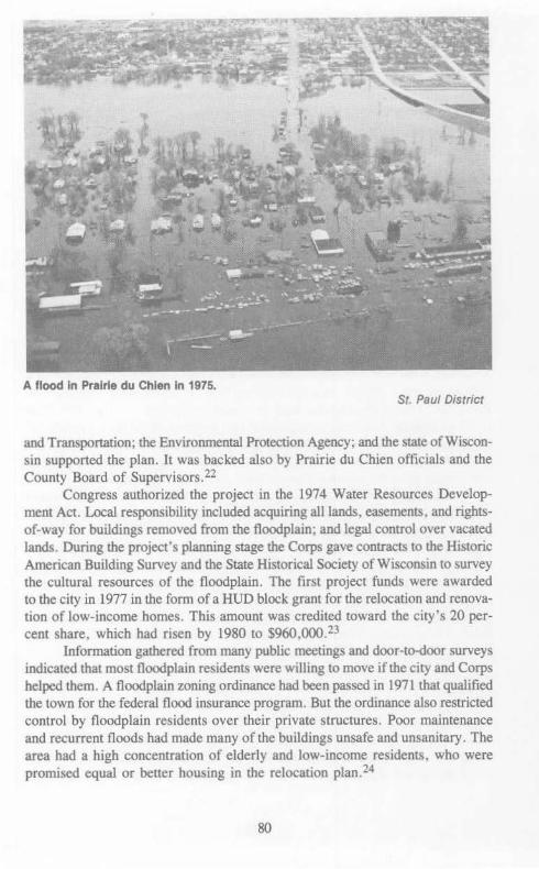
A flood In Prairie du Chien In 1975. St. Paul District
and Transportation; the Environmental Protection Agency; and the state of Wisconsin supported the plan. It was backed also by Prairie du Chien officials and the County Board of Supervisors.22
Congress authorized the project in the 1974 Water Resources Development Act. Local responsibility included acquiring all lands, easements. and rightsof-way for buildings removed from the floodplain; and legal control over vacated lands. During the project's planning stage the Corps gave contracts to the Historic American Building Survey and the State Historical Society of Wisconsin to survey the cultural resources of the floodplain. The first project funds were awarded to the city in 1977 in the form of a HUD block grant for the relocation and renovation of low-income homes. This amount was credited toward the city's 20 percent share, which had risen by 1980 to $960,()()().23
Information gathered from many public meetings and door-to-door surveys indicated that most floodplain residents were willing to move if the city and Corps helped them. A floodplain zoning ordinance had been passed in 1971 that qualified the town for the federal flood insurance program. But the ordinance also restricted control by floodplain residents over their private structures. Poor maintenance and recurrent floods had made many of the buildings unsafe and unsanitary. The area had a high concentration of elderly and low-income residents, who were promised equal or better housing in the relocation plan. 24
80

Some floodplain residents, however, had doubts about the relocation project, and a few even refused to consider moving. Both city and Corps officials recognized from the start that the project would be disruptive and traumatic to those uprooted from their familiar surroundings. Prairie du Chien Mayor John McPhee stated that some of the opposition to the project was due to typical reaction against ''any action that makes poor people better off.'' Nevertheless, some floodplain residents felt they would rather tolerate occasional flooding than move. Because the area required extensive flood control measures, and because most floodplain residents favored relocation, the eventual relocation of all 128 residences was deemed necessary. The benefits of advisory and financial assistance that residents received by moving from the floodplain convinced most floodplain residents to cooperate; more than one-half of the eligible island homeowners volunteered for the first year of relocation in 1978.25 The Corps drew up a detailed plan for relocation of the families.26 By early 1981 the acquisition of properties was nearly 50 percent complete and thus far, all relocated families have volunteered to move. The scheduled completion date was fiscal year 1983.27
The relocation of Prairie de Chien in 1978- a house-by·house solution to the flooding problem.
St. Paul District
The Wisconsin senators responded much differently to the Prairie du Chien project than they had to the Kickapoo dam proposal. In 1979 Senator Nelson stated that "the Prairie du Chien plan is a tangible example that alternatives to traditional solutions are cost-effective and environmentally compatible." The benefitcost ratio provided to Congress for the project was 1: 1. Proxmire summed up the feelings of many citizens concerning the planning process:
I am delighted that the Corps of Engineers and the City of Prairie du Chien have worked closely together to develop a nonstructural alternative to the impoundment of a free-flowing river to prevent future flood los.ses. Because of its innovative approach, this project is one of the relatively few Federal flood control programs that has drawn absolutely no opposition from environmental groups.
81
This short review of only 3 of more than 200 flood control projects studied by the Corps of Engineers since World War II on the upper Mississippi River watershed shows a modified Corps policy. Floodwalls, levees, and dams are not the only solutions to alleviating the problems of high water. Some bottomlands, like those adjacent to the business section of St. Paul, are much more valuable than others. Certain communities, like Prairie du Chien, have lived with floods for more than 200 years. Others, such as La Farge and Soldiers Grove, are located in economically depressed areas. The same solution cannot be applied to each situation. The construction of public works to save floodplains means that water will move more rapidly out of one section only to cause more damage downstream.
The La Farge dam "affair" is a prime example of a federal construction project caught up in a national debate over environmental policy. It began as a traditional "structural" approach to flood control. It was enlarged to a multipurpose flood control project in order to include recreational and regional economic development as part of its overall benefits. During the 1970s a strong national environmental movement led in part by Wisconsin media, political figures, and conservation groups focused on the problem of' 'structural'' alternatives to flood control. Eutrophication of reservoirs behind large dams became a major issue and the La Farge project was debated in the courts and in political campaigns. Unfortunately, the local citizens of the Kickapoo valley became the victims of this discussion, which was centered in Madison, the home of the capital, the state's major media, and the university community. Prior to the debate over environmental policy, land acquisition for the project had been completed. Thus, local tax rolls never materialized. Floods continued to devastate the Kickapoo communities. An economically depressed area became more depressed as a result of the stalemated project. By the time the Corps had developed ''nonstructural'' alternatives for the project, inflation and high interest rates made the project too expensive to justify costs. The half-finished dam stands as a testimonial to a mid-stream change of environmental consciousness on the part of federal and state leadership.
For many years engineers have asked for comprehensive watershed plans to control the damages caused by excessive snow melts and thunderstorms. The location of reservoirs on the main tributaries to a main river is one of the main building blocks in such schemes. During the 1960s the Corps of Engineers planned to control flooding on the Mississippi by constructing a large reservoir on the St. Croix River. This project's defeat was one more phase in the transition of the public works policies of the Corps of Engineers. The former policies were modified by a new concept: the wild and scenic river.
82

IX
WILD AND SCENIC WATERS: THE FREE-FLOWING CHANNEL
During the 1960s, the public became increasingly concerned about the environment. Commercial and industrial encroachment on the nation's rivers and streams and the loss of pure water for recreation alarmed many residents on the upper Mississippi watershed. Early in his term, President Lyndon Johnson committed his administration to fighting water pollution and to protecting the country's natural heritage. In 1965 the Interior Department's Outdoor Recreation Resources Review Commission urged expanding the nation's outdoor recreation facilities by recommending that "certain rivers of unusual scenic, esthetic, and recreational value should be allowed to remain in their free-flowing state and natural setting without manmade alterations." The Interior Department then drafted a ''wild rivers'' bill to preserve parts of the dwindling number of undeveloped rivers in their natural condition. The upper St. Croix, and its 90-mile tributary in Wisconsin, the Namekagon, was one of the longest free-flowing rivers of the 22 waterways recommended for inclusion in the system. 1
The St. Croix River travels 165 miles from its source, the St. Croix Lake in northwest Wisconsin, to its junction with the Mississippi River at Prescott, Wisconsin. Since 1948 the lowter 127 miles of the river have formed a border between Wisconsin and Minnesota. The Corps of Engineers became responsible for maintaining a three-foot navigation channel on the St. Croix from the mouth of the river to Taylors Falls, Minnesota (a distance of approximately 51 miles), in 1878. Later modifications resulted in the establishment of a six-foot channel from the mouth to Stillwater, Minnesota, a distance of about 24 miles. When the construction of Lock and Dam No. 3 on the Mississippi River created a new reservoir in 1938, a nine-foot channel was established on the lower end of the St. Croix. The Corps' authorization to improve the Stillwater harbor and the new nine-foot channel raised local expectations that a new industrial sector would evolve along the St. Croix valley. 2
However, it was the very lack of industrial development that made the region attractive and popular to others. The forests that had vanished during the logging era reappeared throughout the valley. The heavily reforested wilderness,
83

punctuated by occasional marshes and clearings, provided an ideal habitat for wildlife. The fast-flowing St. Croix provided excellent fishing and canoeing, especially in the shallower waters of the upper river. The region was unspoiled and in relatively close proximity to St. Paul and Minneapolis, affording Twin Cities vacationers a recreational paradise. 3
In January of 1965, Senators Walter Mondale of Minnesota and Gaylord Nelson of Wisconsin introduced a bill, designating the portion of the St. Croix between Taylors Falls and a dam near Gordon, Wisconsin, as a National Scenic Waterway. Nelson referred to the St. Croix as "the last large clean river near a major metropolitan area in all of the Midwest.'' Representative Joseph Karth of Minnesota submitted a similar bill in the House. The Department of the Army opposed section 8 of the St. Croix bill, which prohibited any structural changes to the river. They wished to retain their authority to "improve" certain segments of the river. 4
One of the major reasons for Secretary of Army Ailes' position on section 8 was the Corps of Engineers' concern with the periodic flooding of several communities located on the St. Croix. Engineers had considered building flood control structures on the St. Croix in 1930 and again in 1952, but the suggestions to construct a dam were rejected. Flood control studies were put aside until1965, when a spring flood caused extensive damage throughout the upper Mississippi River valley. Damages to the St. Croix River basin alone were an estimated $5.5 million, approximately one-half of which occurred at Stillwater, Minnesota, and Hudson, Wisconsin. In addition, waters from the St. Croix added to the destruction downstream on the Mississippi. About 20 percent of the floodwaters came from the St. Croix watershed during this major inundation. 5
The Corps argued that if water were impounded on the upper St. Croix, water levels could be reduced on both the lower St. Croix and the upper Mississippi. The Minnesota River b>asin and the Mississippi above Minneapolis were also primary sources of major Mississippi River floods. The Corps investigated all of these areas for potential reservoir storage sites in an effort to prevent the recurrence of disastrous flooding. Investigations showed, however, that storage sites on the Mississippi and its tributaries above Minneapolis were either too small or too far north to effectively reduce flood peaks below the Twin Cities. Consequently, the St. Paul District concentrated on determining the best available storage sites on the St. Croix and Minnesota rivers. 6
In January 1966, a public hearing was held at Stillwater on a proposal to construct a flood control dam on the St. Croix at or near the site of the old Nevers logging dam. The 1965 flood focused local interest in flood control. The St. Croix Standard Press noted that the need for flood control ''brought all factions represented at the meeting into a spirit of cooperation and common concern over a public tragedy which threatens again this year.'' In addition, participants learned that reservoir benefits included the creation of a large recreation lake, a deeper navigation channel upstream, better fishing, and an improved environment for wildlife.7
84

Early in 1967 more information was released. The Corps of Engineers' studies concluded that a site on the St. Croix would have a larger potential storage capacity than any tributary of the Mississippi in that area. A Corps dam and lake were the most economically feasible alternatives. This announcement touched off increasingly vehement and well-organized opposition to both the reservoir proposal and to the Corps as a dam-building organization. The Twin Cities press led the fight.
The Corps proposed a dam 1 to 8 miles upstream of Taylors Falls, Minnesota, which would tum a portion of the upper St. Croix into a 114-mile lake. This action, according to the St. Paul Pioneer Press, would inundate thousands of acres of wooded terrain during some seasons, and create "a muddy waste" during others. Although the dam's primary purpose was flood control, the Pioneer Press pointed out that possible hydroelectric installations at the dam site would result in increased industrial development. Although the Corps' reservoir studies were as yet tentative, the editor claimed that "studies always start under innocent 'tentative' labels, but there is an ominous history in many cases of unstoppable progression after preliminary headway is made.'' The Pioneer Press and others encouraged the passage of the St. Croix Scenic River bill, and suggested that the Corps of Engineers look into possible levees, dikes, and other flood control methods on the St. Croix, as well as floodplain zoning. 8
-
Colonel Richard J. Hesse, the District Engineer at St. Paul, responded to the press criticism. He admitted that ''one or more reservoirs could adversely affect certain natural resources'' but also pointed out that the reservoir would ''provide a partial solution of some of the critical water problems of the region.'' He stressed that the St. Croix study was only in the preliminary stages, and that it would consider values other than economic feasibility. The Corps had to adhere to federal planning and water resource development guidelines set forth in 1962. This legislation emphasized that the well being of people was to be the overriding determinant in considering water resource development. According to Colonel Hesse, information collected after the 1965 flood would provide data on how many people would benefit from the proposed project. Although admitting that alternative methods of flood control were possible, Hesse stated that the "reservoir storage is the only method that will prevent the damage and traffic interruptions on the highways and railroads in the floodplain and will reduce the flood damages in the extensive rural areas.' •9
In August, at the request of Chairman Wayne N. Aspinall of the House Committee on Interior and Insular Affairs, the Department of the Army defined its position on the wild rivers lt>ill. A Department letter explained that ''the nation can well afford to forego the development of streams of unusual natural beauty,'' but that Congress' decision to set aside such streams must be based on a full report and plan for each river. These reports would present ''wise decisions'' outlining both the advantages of preserving the rivers in their natural state and the economic values that would accrue from their development. In this way, ''before the Congress makes its final decision it will know what the nation would be giving up
85

in the form of material wealth in order to preserve the intangible benefits of an unspoiled natural area.'' Several months later, Wisconsin Governor Warren P. Knowles expressed apprehension over the Department's goal of informing Congress of both the economic values of river development and the "intangible" values of wild river status. Knowles believed it was "doubtful that such a comparison is possible because there is no way to properly assign comparative economic values to these intangibles of beauty, solitude, wilderness inspiration, and fish and other wildlife.'' 10
The Corps released their completed two-and-a-half-year preliminary study of the St. Croix early in 1968. The Corps indicated that it would be economically feasible to construct a 100- to 120-foot-high dam on the St. Croix about 10 miles north of Taylors Falls. The dam would eliminate the possibility of setting aside that portion as a wild river. Approximately 40 miles of the sparsely settled upper St. Croix would be turned into a reservoir, covering 75,000 acres of land, and extending the pool over 114 square miles. The small town of Sunrise, Minnesota, would be inundated. Besides flood control for the whole upper Mississippi, additional benefits included more facilities for fishing, boating, and other recreation; hydroelectric power; surplus water that could be diverted to the Twin Cities for future water needs; and supplementary water during times of low flow on the Mississippi and lower St. Croix.ll
The preliminary study soon exploded into a controversial regional and even national issue. The Northern States Power Company, which owned approximately 30,000 acres of land along the St. Croix, opposed the idea of a dam as incompatible with the preservation of the river's wild characteristics. The major supplier of electricity in the area consequently joined environmental groups and concerned citizens in the campaign against the Corps' proposal. The editors of a growing number of newspapers fought for the river's preservation. The Minneapolis Star felt that the dam "might be practical but in our opinion it is a mistake," and reported that local support for the proposed dam had dwindled. ''Major floods have not been frequent on the St. Croix and residents seem willing to risk an occasional wet basement for the privilege of enjoying the beauty of the valley.'' The Minneapolis Tribune encouraged floodplain zoning and management, and pointed out that the Corps itself admitted that the high water levels of the 1965 flood were likely to occur about once every 100 years. The Corps' response, that a reservoir capable of controlling a 1 00-year flood would provide complete control during all floods equal to or smaller than the 1965 flood, received little media support. 12
Meanwhile, Minnesota and Wisconsin congressmen were urging quick congressional action for preserving the St. Croix and Namekagon. The Senate passed legislation declaring the St. Croix a scenic waterway in the 89th and 90th Congresses, but the House held up its wild rivers bill. In addition, the House bill only included the lower St. Croix! Congressman Joseph Karth of Minnesota encouraged the inclusion of the upper St. Croix and N amekagon in the wild rivers bill. He noted that under the proposed bill, "one of the most beautiful spots in
86

The upper St. Croix - a "wild and scenic river." St. Paul District
this country will be at the bottom of a 40-rnile-long lake.'' Senator Nelson went before a congressional committee to oppose the Corps' darn proposal, stating that • 'the Corps of Engineers is like that marvelous little creature, the beaver, whose instinct tells him every fall to build a dam wherever he finds a trickle of water.'' 13
A St. Paul Pioneer Press editorial acknowledged Nelson's remark, and observed that "the beaver builds for a reason, but the Army Corps boys seem to build just for the sake of building." The Press then asked, "Is an expensive dam, a forever ruined wild river, and a permanent public displeasure worth it just to prevent raging waters once every 100 years?"l4
Harry Carlson of the St. Paul District Basin and Project Planning Section notified the Minnesota-Wisconsin Boundary Area Commission that "the area that would be inundated is sparsely populated and of relatively low financial value.'· Yet the Boundary Area Commission opposed the darn and testified before the House Committee on National Parks and Recreation for wild rivers status for the St. Croix and Namekagon. The commission declared a darn incompatible with the best and highest use of the land and water in the St. Croix valley. 15
Statements in favor of the proposed dam emerged occasionally, usually in regard to the importance of controlling flood damages. The Winona Daily News, for example, reported that in certain cases" 'Wild Rivers' become secondary. »16
But in spite of such statements, the Corps was clearly on the defensive. The St.
87

Croix dam issue portrayed the Corps as a destroyer of the environment. Such judgments lacked historical perspective. The St. Paul District had been responsible, for example, for acquiring many thousands of acres that had provided Wisconsin and Minnesota with wildlife management and recreation. Instead, the Corps was depicted as a governmental public works firm that needed new construction projects to stay in business. Few people wished to listen to an argument based on economic feasibility. Even the matters of water supply and recreation were ignored. The issue became preservation of the natural environment.
In an attempt to present the Corps' position, J. Robert Calton, St. Paul District Chief of Basin and Project Planning, discussed the benefits of the proposed dam in a speech before the St. Croix Valley Chamber of Commerce in March 1968. He emphasized that recreation facilities could be developed with much greater scope than if the St. Croix was designated a wild river. Calton cited estimates that annual revenues from reservoir visitors would exceed $3.5 million by the year 2020. The Corps engineer admitted that wildlife within the reservoir area would be adversely affected, but pointed out that the reservoir would benefit fish habitats above and below the reservoir. The key point, however, was that "substantial flood control reservoir storage on the St. Croix River is highly desirable.'' Acknowledging the widespread controversy over the Corps proposal, he observed that ''to plan for the future is a difficult and often thankless task.'' 17
During the month of April 1968 the Twin Cities newspapers kept the issue before the public. The Minneapolis Star softel)ed its approach somewhat by stating that the Corps ''for all its good work, is an empire-building agency which sometimes needs its public work ambitions curtailed.'' The Corps of Engineers also softened its position. General William Cassidy, Chief of Engineers, advised the North Central Division Engineer that the St. Croix situation could be "a unique opportunity to demonstrate" the Corps' "capability as a competent, objective, national planner in the public interest.'' 18 He asked for cooperation from all state, federal, and local government agencies to work out a comprehensive plan for the river. F.E. Anderson, Jr., assistant director of Civil Works for the North Central Division, proposed further studies, considering public and congressional interest in preserving the river. St. Paul District Engineer Hesse promised to develop flood-planning alternatives that would be ''in the broad public interest.'' 19
Congress, however, was not interested in more studies of the St. Croix. Senator Proxmire joined Senators Mondale and Nelson in opposing any additional funding for Corps review of the river. They insisted on immediate passage of the wild rivers bill. Wisconsin Governor Warren Knowles wrote to Colonel Hesse advocating wild river designation without delay. Representative Karth again suggested that the Corps look to floodplain management, and reported that a recent poll of his constituents had generated 14,000 responses of nine to one in favor of preserving the St. Croix. 20
The Northern States Power Company helped assure the inclusion of the St. Croix in the final Wild and Scenic Rivers bill. The company agreed to convey without cost approximately 70 miles along the river to the federal govern-
88

ment and to Wisconsin and Minnesota, if the area became part of the wild rivers project. The company also sponsored a 30-minute film, ''Waters of the St. Croix,'' which promoted the preservation of the river in its natural state. On 2 October 1968, Congress passed the Wild and Scenic Rivers Act, preserving eight waterways "in free-flowing condition." The St. Croix River above Taylors Falls along with the entire Namekagon tributary was included. The lower St. Croix was set aside for further study and possible later addition to the wild rivers system. 21
The Wild and Scenic Rivers Act prevented further consideration of the upper St. Croix for reservoir storage purposes. The controversy was over, leaving the Corps with a tarnished image that it was eager to forget. The public works tradition, which had been the pride of the Corps for 100 years, had been seriously challenged. Further efforts in the St. Paul District anticipated that the Corps would become a federal planning organization that respected the natural environment and worked to preserve precious natural resources. An institution that was once proud of "making the dirt fly" began a policy of hiring environmental specialists.
89

A tow of barges on the Mississippi River passes between the town of Lansing, Iowa, and the Upper Mississippi River Wildlife and Fish Refuge.
St. Paul District
90

PART THREE: A NEW BEGINNING, 1970-1980
The 1960s were a period of serious reflection on the rate and complexity of material development. The decade was not just a passing segment of protest marches, utopian experiments, amplified music, flower children dancing in the parks, and teenagers learning Barry Commoner's four laws of ecology. Academic scholars, newly endowed institutes, government agencies, social organizations, media representatives, and cultural groups began to assess the impact of technology on contemporary civilization. The first studies took a negative view toward the complex technological systems that have come to dominate human life. Chemicals were found in the life chain, emissions from automobiles and industry filled the air, and such beneficial products as soap were destroying the nation's groundwater supply. Reports documented the vast consumption of the earth's natural resources at an alarming rate. Many voices were raised about slowing down the ''megamachine'' of modern civilization.
A second phase of literature of the late 1960s and 1970s pointed to the fact that mankind has always depended on technology. A more mature assessment noted that the choice was not an attempt to return to simple tools and machines, but to explore ''alternative technologies. '' The idea of examining ''alternatives'' became the policy of most public improvements. In the meantime, the engineering profession had experienced a similar period of critical evaluation. The fact that many decisions had been made by isolated experts working in very specialized areas of knowledge became evident. A coordinated or comprehensive approach to problem solving was noted. Design teams, which were once made up of specialists from one field of study, were now interdisciplinary groups. In addition, many special interest factions were being consulted at the crucial steps in the planning, implementation, construction, and evaluation stages of any federal project. Public participation, interdisciplinary approaches, problem solving, and the generation of technological alternatives became an accepted approach for starting any important public work. Laws passed during the 1970s provided guidelines to this approach.
The Corps of Engineers, which is the nation's largest single engineering agency, began to adopt these methods of comprehensive design in the 1970s. Other agencies, such as the Upper Mississippi River Basin Commission, were established to address the complex issues of water resource and water quality management. One of the intergovernmental "new Imperatives" that was created to
91

"devise a rational management strategy" for the upper Mississipi River was the Great River Environmental Action Team (GREAT). The following chapter describes the evolution of this ex}Oeriment in interdisciplinary organization.
92

X
INTERGOVERNMENTAL WATERS: THE GREAT RIVER IDEA
The upper Mississippi River serves a multitude of interests that place diverse and often conflicting demands on the land and water resources of the watershed. Historically, there has been very little coordination or cooperation between the federal agencies and natural resource units of river-bordering states. Little effort has been made to develop a comprehensive plan of river management that would address social, environmental, and economic needs. In addition, separate congressional actions have dictated that the upper Mississippi be managed in the national interest to serve navigation, commerce, and fish and wildlife. Congress authorized the Corps of Engineers to operate and maintain a nine-foot navigation channel on the upper Mississippi from Cairo to Minneapolis. This channel runs through approximately 266,000 acres of federal fish and wildlife refuge and state game management areas.l
The 29 locks and dams between St. Louis and Minneapolis were constructed to aid navigation. The system provided many benefits to wildlife and public recreation in some parts of the river system, but it also caused serious environmental problems in other areas, primarily because of certain channel maintenance practices. The practice of disposing of dredged materials in marshes, backwater channels, and sloughs often destroyed natural habitats. Many felt that navigation and commercial demands on the upper Mississippi overshadowed the needs of other river uses. Concern ov~r the Corps' channel maintenance methods, and increasingly conflicting management practices among governmental units involved with river management, made clear the fact that the problems associated with the watershed needed identification, examination, and resolution. 2 The Upper Mississippi River Basin Commission (UMRBC) was established in 1972 by a Presidential executive order at the request of the governors of the states within the upper Mississippi River drainage basin. The purpose of the UMRBC was to develop a region-wide river management plan that would cover all aspects of the basin's water and land resources. The commission included members from the ten major federal agencies with related resource programs and the governors of each state· in the upper Mississippi River basin. 3
93

Litigation brought against the Corps' dredging operations by the state of Wisconsin in 1973 led the St. Paul and Rock Island Districts of the Corps to prepare environmental impact statements in accordance with the National Environmental Policy Act of 1969. The resulting documents described the serious damage to the environment caused by the channel maintenance program. They also disclosed that little scientific information was available on many aspects of the upper Mississippi. The lack of data concerning man's impact on the river's resources hindered planning for the future.4
Among those expressing concern over the results of the environmental impact statements was the Minnesota-Wisconsin Boundary Area Commission. This citizen commission, organized in 1965 by Wisconsin and Minnesota, was created to study and make recommendations concerning water resource issues related to the Mississippi and St. Croix rivers. The ten-member commission voted unanimously to send a delegation to Washington to inform Congress of the problems resulting from current channel maintenance practices on the navigation channel. Specifically, the commission requested an appropriation to fund interdisciplinary studies and field tests on the environmental effects of channel maintenance. The commission sought accurate data for future resource planning and decision making. Members of the commission recognized the need for both commercial and recreational uses of these waterways and believed that the upper Mississippi was capable of accommodating all users in an environmentally sound manner. But the commission emphasized that only coordinated interdisciplinary eff9rts would solve the complex problems of the upper Mississippi. They could not be addressed by a single state or federal agency. 5
Minnesota Congressman Albert Quie and Wisconsin Congressman Vernon Thompson supported the commission's testimony to Congress in 1974. The commission requested an additional appropriation to the Corps' budget of $1 million to undertake special studies and field tests in fiscal year 1975. Congress authorized $375,000 for these studies and tests on the stretch of the upper Mississippi between Minneapolis and the mouth of the Missouri River. 6
With the heightened awareness of Congress and the public about upper Mississippi River management problems, the Corps North Central Division Engineer and the U.S. Fish and Wildlife Service's North Central Regional Director formed a partnership in September of 1974. They requested that the Upper Mississippi River Basin Commission, of which both were members, organize a study to re-examine all important values and resources of the upper Mississippi rather than only channel maintenance problems. They asked that the UMRBC develop a management plan for the multi-purpose use of the river. Such a plan would include the effects of dredged material disposal, fish and wildlife habitats, water quality, recreational needs, floodplain management, and other vital river issues.
The Upper Mississippi River Basin Commission had established a cooperative ''Dredge Spoil Practices Committee'' consisting of representatives of the five principal river basin states and five river-oriented federal agencies.
94

The commission broadened the scope of this committee in October 1974 to form the ''Great River Environmental Action Team,'' or simply, GREAT. This team was to be a broad-based, federal-state task force organized to develop a coordinated and balanced plan for managing the resources of the upper Mississippi River valley.7 In October 1974 the commission gave GREAT the following set of objectives:
1. Develop ways to reduce significantly the volume of dredged material removed for the navigation project.
2. Open backwater areas that have been deprived of necessary freshwater flow as a result of navigation maintenance activity.
3. Ensure necessary capability to maintain the total river resources on the upper Mississippi River in an environmentally sound manner.
4. Contain or stabilize all floodplain dredged material placement sites to benefit the river resources.
5. Assure that all navigation project authorizations include fish, wildlife, and recreation as project purposes.
6. Develop physical and biological baseline data to identify factors controlling the river system.
7. Identify sites that can be developed to provide for fish and wildlife habitats irretrievably lost to water development projects.
8. Identify and develop ways to use dredged material as a valuable resource for productive uses.
9. Implement programs to provide for present and projected recreation demands on the river system.
10. Strive to comply with federal and state water quality standards. 11. Strive to comply with federal and state floodplain management standards. 12. De:yelop procedures for ensuring an appropriate level of public participation.
The original team studied that segment of the upper Mississippi from the head of navigation at Minneapolis to Lock and Dam No. 10 at Guttenberg, Iowa. In 1976 a second team, "GREAT II," was formed to study the Mississippi from Guttenberg to Saverton, Missouri. One year later "GREAT III" was established to study the river from Saverton to the mouth of the Ohio River at Cairo. Each of the three teams faced separa~e but similar issues. For example, all three examined fish and wildlife management, water quality, alternative dredge spoil uses, and recreation. Significant differences in topography, climate, and land and water conditions over 800 miles of the upper Mississippi meant that site-specific investigations were required. The conditions, for example, are much different in the stretch of river from Cairo to St. Louis, where slackwater pools do not exist and wing dams are used to maintain the river channel. In each team, representatives from appropriate states and federal agencies participated on an equal basis. GREAT I, for example, was composed of representatives from the states of Minnesota, Wisconsin, and Iowa; the Soil Conservation Service; the Environmental Protection Agency; the Fish and Wildlife Service; the Corps of Engineers; and the Coast Guard. The Upper Mississippi River Basin Commission and the
95

Minnesota-Wisconsin Boundary Area Commission also participated in a nonvoting capacity.8
During the first two years, GREAT expenses were paid by Corps of Engineers operation and maintenance funds. In 1976 the GREAT study was aut}lorized by Congress in section 117 of the 1976 Water Resources Act. The authorization asked the study group to develop a multi-purpose plan for the upper Mississippi. All three teams organized a series of work groups, each concerned with a certain river resource or issue. Every work group included a voting member from each participating state and agency, and was directed to carry out objectives related to the group's subject. This task required extensive data collection and detailed analysis. Each work group was led by the representative of the state or agency that had the most expertise in the area. For example, the Fish and Wildlife Management Work Group was chaired by the U.S. Fish and Wildlife Service in GREAT I. 9
The GREAT I team's policy was that "total resource management plans require interdisciplinary planning to address the broad range of complex issues involved including economic, environmental, and social consequences of plan implementation.'' This became an important guideline for all involved in the GREAT study .10
GREAT members urged the public to serve in the work groups and to become involved in meetings. Within each team a special public participation work group was established, which was responsible for gathering public feedback and for keeping the public aware of the progress of GREAT. Members held a series of public meetings in towns in Wisconsin, Iowa, and Minnesota in 1974 and 1975 at the very start of the GREAT study to gather citizen reaction. The comments collected were forwarded to the appropriate work groups of GREAT I for consideration. Similar public meetings were held at the beginnings of GREAT II and GREAT m.Il The participation of federal and state experts and concerned citizens ensured that problems relating to commercial navigation, fish and wildlife, public recreation, and cultural resources received a public forum.
Several pilot and demonstration programs were conducted by GREAT on selected areas of the river to test better methods of channel maintenance and environmental improvement. One experiment, the stockpiling of dredged materials in Minneapolis for use by the city as fill, to sand icy streets, or for other beneficial uses, proved successful. Demand for the material exceeded the supply. Both the Rock Island and St. Paul Districts experimented with side channel opening to improve and restore backwaters damaged by excessive sedimentation and dredge deposits. Reducing dredge depths to 11 and 12 feet in some areas of the St. Paul District segment of the upper Mississippi lowered dredging volumes during the study period with no serious adverse effects to navigation on the channel. There is some concern that the success of reduced-depth dredging might have been largely due to several low flow years on t!he upper Mississippi, but GREAT I concluded that reduced-depth dredging will continue to be possible in selected areas if certain guidelines are followed. 12
96

The GREAT teams have finished their studies, and all but GREAT I's report have been published. While GREAT I and GREAT II started out to develop a total river resource management plan, time and funding limitations narrowed the scope of their studies. Both teams made considerable contributions toward the original goal, but the primary focus of the team efforts became channel maintenance. The teams examined the impact of the nine-foot channel navigation project and developed recommendations and plans for future channel maintenance taking into account all river resources. The teams' channel maintenance recommendations include guidelines for detailed site-specific locations as well as for managing tlhe entire river system, although some recommendations violate current state and federal statutes. Channel maintenance recommendations are based on pilot studies, extensive site evaluations, water quality tests, dredge spoil investigations, and numerous other considerations. Already, St. Paul District is implementing, on various parts of the river, some of GREAT l's recommendations. If the District can acquire increased funding and authorization, it will be able to implement many others. 13 GREAT I and GREAT TI recommended further studies and suggested the organization of ongoing interdisciplinary and interagency teams to follow up on GREAT recommendations.14
The findings of GREAT I, II, and m as well as other relevant river studies will be incorporated into an ''Upper Mississippi River Basin Commission Comprehensive Master Plan." Authorized in 1978, the master plan was designed to identify the social, economic, recreational, and environmental objectives of the upper Mississippi River valley and to recommend legislation and guidelines to meet those objectives. GREAT will help the basin committee accomplish its plan. 15 Whether this plan becomes a working synthesis or simply another set of uncoordinated studies of special problems on the river remains to be seen.
As can be seen from this historical study, river management policies have changed to accommodate new technologies, evolving economic interests, and environmental advocates. Such bodies as the UMRBC and the GREAT study groups provide forums for gathering data and developing comprehensive plans that will be more responsive to the.,general welfare. The GREAT river study is a model of federal and state agencies working together in an effective, joint effort to achieve common goals. It is a significant first step to open lines of com:munication among the public, the states, and the federal agencies involved with environmental issues on the upper Mississippi River.
97

Notes
Part One 1. Blake McKelvey, American Urbanization: A Comparative History (Glen
view, Illinois: 1973), p. 73 2. Raymond H. Merritt, Creativity, Conflict and Controversy: A History of
the St. Paul District U.S. Army Corps of Engineers (Washington, D.C.: 1979), pp. 67-69.
Chapter I- Headwaters: Scalping the Indians 1. Annual Report of the Chief of Engineers 1892 (hereafter cited as Annual
Report), p. 1894. 2. Annual Report 1892, pp. 1824-28; U.S. Statutes at Large, vol. 21 , p. 193. 3. Robert A. Janke, "The Development and Persistence of U.S. Indian Land
Problems as Shown by a Detailed Study of the Chippewa Indian," (Ph.D. Dissertation, University of Minnesota, 1976), p. 284; Carollissa Levi, Chippewa Indians of Yesterday and ·Today (New York: 1956), p. 351.
4. 46th Cong., 3d sess., S. Ex. Doc. 48, p. 14; U.S. Statutes at Large, vol. 21, p. 481.
5. 48th Cong., 1st sess., H. Ex. Doc. 76, "Damages to Indians," p. 9. 6. Charles E. Flandrau, "The Work of Bishop Whipple in Missions for the
Indians," Minnesota Historical Society Collections, vol. 10, pt. 2 (Feb. 1903), pp. 691-720; 48th Cong., 1st sess., H. Ex. Doc. 76, pp. 6-8.
7. 46th Cong., 3d sess., S. Ex. Doc. 48, p. 59; 48th Cong., 1st sess., H. Ex. Doc. 76, pp. 6-8.
8. 48th Cong., 1st sess., H. Ex. Doc. 76, p. 10. 9. 48th Cong., 1st sess., H. Ex. Doc. 76, pp. 8-15. 10. 48th Cong., 1st sess., H. Ex. Doc. 76, p. 18; Annual Report of the Com-
missioner of Indian Affairs 1883, p. 154. 11. 48th Cong., 1st sess., H. Ex. Doc. 76, pp. 26, 32. 12. 48th Cong., 1st sess., H. Ex. Doc. 76, pp. 29-33. 13. 48th Cong., 1st sess., H. Ex. Doc. 76, pp. 26-33. 14. 48th Cong., 1st sess., H. Ex. Doc. 76, pp. 34-36. 15. 48th Cong., 1st sess., H. Ex. Doc. 76, p. 21. 16. 48th Cong., 1st sess., H. Ex. Doc. 180; Annual Report of the Commis
sioner of Indian Affairs 1885, p. 343. 17. U.S. Statutes at Large, vol. 23, p. 254; 49th Cong., 1st sess., S. Ex.
Doc. 117; U.S. Statutes at Large, vol. 25, p. 642; 51st Cong., 1st sess., H. Ex. Doc. 247, "Chippewa Indians in Minnesota," pp. 4-5.
18. 51st Cong., 1st sess., H. Ex. Doc. 247, pp. 20-21; 54th Cong., 2d sess., House Report No. 2984; Annual Report 1892, p. 1833.
99

19. Annual Report of the Commissioner of Indian Affairs I905, pp. 230-231. 20. Merritt, Creativity, Conflict and Controversy, pp. I 08-114. 21. Annual Report 1910, pp. 633-635; Annual Report 1907, p. 1584. 22. Annual Report of the Commissioner of Indian Affairs 1929, Record Group
75, National Archives and Records Service (NARS), Rol127; Annual Report of the Commissioner of Indian Affairs 1916, Record Group 75, NARS, Roll 78.
23. Congressional Record, 1Ist Cong., 3d sess., pp. 5573-74. 24. 73d Cong., 1st sess., H. Ex. Doc. 66, "Mississippi River Above Coon
Rapids Dam, Minnesota," pp. 71-72.
Chapter II - Urban Waters: Fighting Refuse 1. William G. Rector, Log Transportation in the Lake States Lumber Industry:
1840-1918 (Glendale, Calif.: 1953), p. 57; Annual Report 1881, p. 1676. 2. Merritt, Creativity, Conflict and Controversy, p. 138; Miscellaneous
newspaper clippings related to river improvement, 1877-1894, National Archives Record Group (NARG 77), series 1643.
3. Annual Report 1881, p. 1679. 4. 46th Cong., 2d sess., Congressional Record, p. 345. 5. Miscellaneous newspaper clippings related to river improvement,
1877-1894, NARG 77, series 1643; 46th Cong., 2d sess., S. Ex. Doc. 157, pp. 1-3.
6. Merritt, Creativity, Conflict and Controversy, p. 138; Miscellaneous newspaper clippings related to river improvement, 1877-1894, NARG 77, series 1643.
7. St. Paul Dispatch (3 Mar. 1880); Miscellaneous newspaper clippings related to river improvement, 1877-1894, NARG 77, series 1643.
8. Major Alexander Mackenzie to J.W. McClung (30 Jan. 1884) in letters and reports sent, 1879-1890, NARG 77, series 1654.
9. St. Paul Pioneer Press (11 Oct. 1882); Miscellaneous newspaper clippings, 1877-1894, NARG 77, series 1643.
10. Annual Report 1884, p. 1558. 11. Roald Tweet, A History of the Rock Island District Corps of Engineers
(Rock Island, Ill.: 1975), p. 53; Annual Report 1889, p. 1740. 12. Annual Report 1891, p. 2156. 13. Albert E. Cowdrey, "Pioneering Environmental Law: The Army Corps
of Engineers and the Refuse Act," Pacific Historical Review, XLVI (Aug. 1975), p. 338.
14. 54th Cong., 2d sess., H. Ex. Doc. 293, pp. 1-13; Cowdrey, "Pioneering Environmental Law," pp. 339-342; U.S. Statutes at Large, XXX, pp. 1151-53.
15. Cowdrey, "Pioneering Environmental Law," pp. 341-343. 16. Annual Report 1903, pp. 1513-18; 54th Cong., 2d sess., H. Ex. Doc.
293, pp. 1-13.
100

Chapter Ill - Logging Waters: Promoting Monopoly 1. Bernhardt J. Kleven, ''The Mississippi River Logging Company,'' Min
nesota History, vol. 27 (Sept. 1946), p. 191; Robert Fries, Empire in Pine: The Story of Lumbering in Wisconsin, 1830-1900 (Madison: 1951), p. 141.
2. Fries, Empire in Pine, p. 146; Commercial Statistics, 1885-1891, NARG 77, series 1642.
3. Kleven, ''The Mississippi River Logging Company,'' p. 201; Ralph Hidy, Allan Nevins, and Frank Hill, Timber and Men: The Weyerhaeuser Story (New York: 1963), p. 88.
4. 52d Cong., 1st sess., H. Ex. Doc. 178, "Government Dams on the Mississippi River," p. 2; 52d Cong., 1st sess., H. Ex. Doc. 183, p. 6.
5. Annual Report 1890, p. 2031. 6. 52d Cong., 1st sess., H. Ex. Doc. 183, p. 7. 7. 52d Cong., 1st sess., H. Ex. Doc. 183, p. 8. 8. U.S. Statutes at Large, vol. 21, p. 282; Hidy, Nevins, and Hill, Timber
and Men, p. 88; Fries, Empire in Pine, p. 154; 52d Cong., 1st sess., H. Ex. Doc. 183, pp. 7-13.
9. 52d Cong., 1st sess., H. Ex. Doc. 183, p. 8. 10. 52d Cong., 1st sess., H. Ex. Doc. 183, p. 2. 11. 52d Cong., 1st sess., H. Ex. Doc. 183, p. 3. 12. 52d Cong., 1st sess., H. Ex. Doc. 183, pp. 8-10. 13 .. 52d Cong., 1st sess., H. Ex. Doc. 183, p. 3. 14. Annual Report 1890, p. 2031; 52d Cong., 1st sess., H. Ex. Doc. 183,
pp. 8-11. 15. 52d Cong., 1st sess., H. Ex. Doc. 183, pp. 11-16. 16. 51st Cong., 2d sess., Congressional Record, p. 2427; Fries, Empire in
Pine, p. 157. 17. 52d Cong., 1st sess., Congressional Record, pp. 1703, 2192. 18. 52d Cong., 1st sess., H. Ex. Doc. 183, pp. 4, 15. 19. Kleven, "The Mississippi River Logging Company," p. 202; 52d Cong.,
1st sess., H. Ex. Doc. 183, p. 17. 20. Hidy, Nevins, and Hill, Timber and Men, p. 88; 52d Cong., 1st sess.,
H. Ex. Doc. 183, p. 6.
Chapter IV - Polluted Waters: Assisting Commerce 1. Mark Twain, Life on the Mississippi (New York: 1961), pp. 327-328. 2. Twain, Life on the Mississippi, pp. 321-322. 3. 53d Cong., 3d sess., H. Ex. Doc. 52, "Preliminary Examination of Quincy
Bay, lllinois"; Annual Report 1891, pp. 21-32. 4.Annual Report 1891, p. 2133; 50th Cong., 2d sess., Congressional Record,
p. 371. 5. Annual Report 1891, pp. 2125-31. 6. Annual Report 1891, pp. 2133-34.
101

7. 53d Cong., 3d sess., H. Ex. Doc. 52; Annual Report 1898, p. 1747. 8. Annual Report 1899, p. 2127; Merritt, Creativity, Conflict and Contro
versy, p. 178. 9. Robert C. Nesbit, Wisconsin: A History (Madison: 1973), p. 332; 53d
Cong., 3d sess., H. Ex. Doc. 78, pp. 1-2, "Preliminary Examination of La Crosse Harbor, Wisconsin"; H .J. Hirshheimer, "The Passing of the Sawmills and the Growth of Manufacturers in La Crosse, 1880-1905,'' La Crosse County Historical Sketches, series 3 (1937), p. 90.
10. Frederick Merk, Economic History of Wisconsin During the Civil War Decade (Madison: 1916), pp. 224-225, 309-310, 320, 354.
11. Albert Sanford and H.J. Hirshheimer, A History of La Crosse, Wisconsin, 1841-1900 (La Crosse: 1951), p. 178; Nesbit, Wisconsin, p. 332; Annual Report of the La Crosse Board of Trade 1901, p. 34.
12. Colonel William King to Chief of Engineers William Craighill (11 Jan. 1897), NARG 77, series 1659, Press copies of letters and reports relating to harbor improvements, levees, and surveys, 1896-1897.
13. Ibid. 14. 53d Cong., 3d sess., H. Ex. Doc. 78. 15. Annual Report of the La Crosse Board of Trade 1898, p. 29; 53d Cong.,
3d sess., p. 1007. 16. 54th Cong., 2d sess., H. Ex. Doc. 210, "Survey of La Crosse Harbor." 17. La Crosse Chronicle (6 Jan. 1897). 18. 54th Cong:, 2d sess., H. Ex. Doc. 210, pp. 1-4 (map); Annual Report
1900, p. 2714. 19. Annual Report of the La Crosse Board of Trade 1897, pp. 27, 34. 20. Mayor Wendell Anderson to the Rock Island Corps of Engineers Office,
Letters Received, N ARG 77, series 1661, vol. 4; Annual Report of the La Crosse Board of Trade 1901, p. 24, and 1898, p. 29; Annual Report 1899, p. 2171.
21.Twain, Life on the Mississippi, pp. 330-331.
Chapter V - Recreational Waters: The Polluted Channel 1. Patrick Brunet, "The Corps of Engineers and Navigation Improvement
on the Channel of the Upper Mississippi River to 1939," (M.A. thesis, University of Texas at Austin, 1977). This thesis has a fine descriptive section on the creation of the wildlife refuge, pp. 145-160.
2. Brunet, ''The Corps of Engineers and Navigation Improvement,'' pp. 146-147.
3. William T. Hornaday, Thirty Years War for Wild Life (Stamford, Conn.: 1931).
4. 68th Cong., 1st sess., Congressional Record, "Upper Mississippi River Wildlife and Fish Refuge," pp. 1415-16; 68th Cong., 1st sess., House Report 747, p. 5; 68th Cong., 1st sess., Congressional Record, p. 10977.
102

s. 68th Cong., 1st sess., Congressional Record, p. 10244; U.S. Statutes at Large, vol. 43, p. 650; Ira Gabrielson, Wildlife Refuges (New York: 1943), p. 14.
6. Brunet, "The Corps of Engineers and Navigation Improvement," pp. 160-163.
7. 69th Cong., 2d sess., H. Ex. Doc. 632, "Stream Pollution in the United States," p. 7; 76th Cong., 1st sess., H. Ex. Doc. 155, "Water Pollution in the United States,'' p. 84.
8. 68th Cong., 1st sess., Congressional Record, p. 5162; 67th Cong., 2d sess., Congressional Record, p. 10244; U.S. Statutes at Large, vol. 43, p. 605; 68th Cong., 2d sess., Congressional Record, p. 3884.
9. Circular No. 9, Rock Island Files, NARG 77, series 1671, Publication Files, 1913-1940; Merritt, Creativity, Conflict and Controversy, p. 180.
10. 69th Cong., 1st sess., H. Ex. Doc. 417, "Pollution Affecting Naviga-tion or Commerce on Navigable Waters," p. 18.
11. Ibid.' p. 9 12. Ibid.' p. 24. 13. Ibid.' pp. 9-10. 14. Ibid.' pp. 23-28. 15. H.R. Crohurst, ''A Study of the Pollution and Natural Purification of
the Upper Mississippi River," Public Health Service Bulletin, no. 203, p. xi. 16. Ibid., p. xii. 17. F.L. Woodward, "Pollution Studies on the Upper Mississippi River,"
Industrial and Engineering Chemistry, vol. 22 (Feb. 1930), p. 189; Crohurst, "A Study of Pollution and Natural Purification, p. 31.
18. 69th Cong., 2d sess., H. Ex. Doc. 583, p. 46. 19. Woodward, "Pollution Studies," p. 189; 69th Cong., 2d sess., H. Ex.
Doc. 583, p. 46. 20. Woodward, "Pollution Studies," pp. 189-192. 21. Ibid., p. 192.
Chapter VI - Commercial Waters: The Nine-Foot Channel 1. 75th Cong., 1st sess., Congressional Record, Appendix, p. 2155; 71st
Cong., 2d sess., Congressional Record, p. 7778. 2. Herbert Clark Hoover, ''The Waterways Outlet from the Middle West,''
(9 Mar. 1926), Herbert Hoover Papers, West Branch, Iowa. 3. 75th Cong., 1st sess., Congressional Record, Appendix, p. 2155; Annual
Report 1927, p. 1084. 4. 72d Cong., 1st sess., H. Doc. 137, "Survey of Mississippi River Between
Missouri River and Minneapolis,'' p. 20; Merritt, Creativity, Conflict and Controversy, p. 196.
s. Merritt, Creativity, Conflict and Controversy, pp. 195-197. 6. 75th Cong., 1st sess., Congressional·Record, Appendix, p. 2155; 70th
Cong. , 2d sess. , Congressional Record, p. 4817.
103

7. 71st Cong., 2d sess., H. Doc. 290, "Mississippi River Between Mouth of Missouri River and Minneapolis, Minn.," p. 3; 71st Cong., 2d sess., Congressional Record, p. 6529.
8. 72d Cong., 1st sess., H. Doc. 137, pp. 23, 102; Annual Report 1930, p. 1191.
9. 72d Cong., 1st sess., H. Doc. 137, pp. 55-63. 10. 72d Cong., 1st sess., H. Doc. 137, pp. 64-65; see also Robert E. Coker,
''Studies of Common Fishes of th~ Mississippi River at Keokuk,'' U.S. Bureau of Fisheries Bulletin 45 (31 Mar. 1930).
11. Arthur S. Pearse, "Fishing on the Mississippi," Scientific Monthly 14 (Feb. 1922), pp. 195, 200.
12. 72d Cong., 1st sess., H. Doc. 137, p. 104; Tweet, A History ofthe Rock Island District, p. 103; Nine-Foot Channel Project, Lock and Dam No. 4, NARG 77, series 395860; 74th Cong., 1st sess., Congressional Record, p. 5279.
13. Brunet, ''The Corps of Engineers and Navigation Improvement,'' pp. 125-126.
14. Ira Gabrielson, "Floods and Wildlife," Scientific American, vol. 156 (Feb. 1937), pp. 100-102; Gabri~lson, Wildlife Refuges, p. 193.
15. Brunet, ''The Corps of Engineers and Navigation Improvement,'' pp. 162-164.
16. See "Maintenance of Water Level in Upper Mississippi River for Wildlife Conservation Purposes,'' Hearings before the Senate Interstate and Foreign Commerce Committee in H.D. 2721 (27 Apr. 1948), 80th Cong., 2d sess., pp. 12-13; Kent D. Keenlyne, ed., Upper Mississippi River Conservation Committee Investigation Reports (Rock Island: Upper Mississippi River Conservation Committee, 1974); Remarks of Representative William H. Stevenson (18 Feb. 1946), Congressional Record, 79th Cong., 2d sess., ''Promoting Conservation of Fish and Wildlife Resources of the Upper Mississippi River," House Report #504, 80th Cong., 1st sess. (1947).
11. Tweet, A History of the Rock Island District, p. 110; Miscellaneous correspondence, Lock and Dam No. 9, NARG 77, series 395933.
18. Miscellaneous correspondence, Lock and Dam No.9, NARG 77, series 395933.
19. North Central Division, Engineering Studies of the Upper Mississippi Valley, 1930-1942, NARG 77, series 395545.
20. Ibid. 21. Ibid. 22. Ibid. 23. Ibid. 24. Annual Report 1937, p. 917; 76th Cong., 1st sess., H. Doc. 137, p. 12;
Claims and Damages, Lock and Dam No. 8, NARG 77, series 395847. 25. North Central Division Engineering Studies of the Upper Mississippi
Valley, 1930-1942, NARG 77, series 395545.
104

Chapter VII - Deeper Waters: The Twelve-Foot Channel 1. ''Stream Channelization-Part 1,'' Hearings before a Subcommittee of the
Committee on Government Public Works (1971), p. 94. 2. Minneapolis Tribune (22 May 1969); "Twelve-foot Channel Study, Phase
I Report," (May 1973), p. 26, in St. Paul District, Mississippi River Twelvefoot Channel Project Files.
3. ''Stream Channelization-Part 1 , '' p. 95. 4. National Observer (28 Dec. 1970). 5. Ibid. 6. Minneapolis Tribune (26 Feb. 1971). 7. "Stream Channelization-Part 1," p. 106; Minneapolis Tribune (26 Feb.
1971). 8. Minneapolis Star (11 Apr. 1972); Viroqua Broadcaster-Censor (28 Aug.
1972); "Stream Channelization-Part 1," p. 94; Winona Daily News (28 Sept. 1972).
9. Upper Mississippi River Basin Coordinating Committee, Upper Mississippi River Comprehensive Basin Study (1972), p. 27; app. J, pp. iv, 27, 96-99, 103.
10. "Twelve-foot Channel Study, Phase I Report," pp. 19, 36, 45; North Central Division, "Water Resources Development," Wisconsin volume (Jan. 1981), p. 60.
11. Corps of Engineers and Environmental Protection Agency, ''Dredging America's Waterways and Harbors," (June 1977), p. 5; Maj. Gen. J.W. Morris, "Our Troubled Waters," Water Spectrum, vol. 6, no. 4 (Winter 1974-1975), p. 3.
12. "Dredging America's Waterways," p. 10; Owatonna People's Press (16 Aug. 1973); Upper Mississippi River Conservation Commission, ''The 1969 Upper Mississippi River Dredge Spoil Survey," (1970), pp. 1-2.
13. "Dredging America's Waterways," pp. 11, 43. 14. Minneapolis Tribune (17 Nov. 1973); Winona Daily News (6 Feb. 1974);
"Dredging America's Waterways," p. 43. 15. "Dredging America's Waterways," p. 43. 16. American Society of Civil Engineers, ''Proceedings of the Special Con
ference of Dredging and its Environmental Effects,'' Mobile, Alabama (Jan. 1976), p. 358; "Dredging America's Waterways," pp. 43-44.
17. "Energy and Work Development Appropriations for 1980," Hearings before a Subcommittee on Appropriations (1979), p. 1856; "Dredging America's Waterways," p. 11.
18. Ibid. 19. Roger T. Saucier, "Dredged Material-Waste Product or Resource?"
Water Spectrum, vol. 10, no. 4 (Fa111978), p. 11; Minneapolis Tribune (14 Feb. 1974).
20. "Proceedings of the Specialty Conference," p. 358; "Dredging America's Waterways," p. 23.
21. Public Notice (1 Mar. 1980), Mississippi River Nine-Foot Channel Proj-
105

ect File, St. Paul District Files; Draft copy, Letter of Maj. Gen. Richard J. Harris to Anthony Earl (29 Aug. 1979), Mississippi River Dredging Project File, St. Paul District Files.
22. See, for example, Kathy Sawyer, "Army Engineers Shift Gears, Go With the Flow Instead of Damming It Up," Washington Post (31 July 1981), p. A3.
Chapter VIII - Runaway Waters: The Flooded Channel 1. Annual Repon 1963, p. 1151. 2. "St. Paul Flood Control Project-Reevaluation Study," (1977), St. Paul
District Flood Control Files; Draft Report, "Preliminary Feasibility Report, Mississippi River at St. Paul, Minnesota, Reevaluation of St. Paul Flood Control Project," (Sept. 1978), p. 23 in St. Paul District Flood Control Project Files.
3. Draft Report, "Preliminary Feasibility Report," p. 22. 4. Draft Report, "Preliminary Feasibility Report," p. 24; "St. Paul Flood
Control Project-Reevaluation Study," pp. i-2; North Central Division, "Water Resources Development," Minnesota volume (Jan. 1979), p. 47.
s. Draft Report, "Preliminary Feasibility Report, Mississippi River at St. Paul, Minnesota," (Aug. 1978), p. 46 in St. Paul District Flood Control Project Files; ''Biological Assessment, Reevaluation of St. Paul Flood Control Project,'' (no date), St. Paul District Flood Control Project Files.
6. J. Robert Calton, "Report on La Farge Lake Project, Kickapoo River, Wisconsin," St. Paul District Kickapoo River Project Files; "Kickapoo River, Wisconsin, Flood Control Project, Dam and Reservoir," (Nov. 1966), St. Paul District Flood Control Files.
7. Milwaukee Journal (27 Oct. 1974); Calton, "Report on La Farge Lake Project," p. I.
8. Gov. Patrick J. Lucey to Ernest Graves, Jr. (20 May 1971), La Farge Lake Project Files, St. Paul District; Wisconsin State Journal (27 Oct. 1974); Madison Capital Times (26 May 1971).
9. ''Environmental Analysis of the Kickapoo River Impoundment: A Report to the U.S. Army Corps of Engineers," University of Wisconsin, Institute of Environmental Studies (Nov. 1974) in La Farge Lake Project Files, St. Paul District.
10. Milwaukee Sentinel (29 July 1975); Milwaukee Journal (6 July 1975); La Farge Epitaph (7 May 1975).
11. Milwaukee Sentinel (29 July 1975). 12. Madison Capital Times (30 July 1975). 13. Milwaukee Journal (7 Sept. 1975); St. Paul Dispatch (9 Jan. 1976);
Madison Capital Times (9 Sept. 1975). 14. Madison Capital Times (22 Oct. 1976); La Crosse Tribune (19 Nov.
1976); Gov. Patrick J. Lucey to Col. Forrest T. Gay ill (28 Jan. 1977), La Farge Lake Project Files in St. Paul District; ''Task Force on Flood Damage in the Kickapoo River Valley, Wisconsin," (Oct. 1978, Memorandum), p. 3 in La Farge Lake Project Files.
106

15. La Farge Epitaph (29 May 1979); La Crosse Tribune (9 Feb. 1979). 16. La Farge Epitaph (25 June 1980); La Crosse Tribune (27 Mar. 1980 and
8 Oct. 1980). 17. Madison Capital Times (22 Oct. 1980 and 21 Dec. 1974); Interview with
Mr. James Braatz, St. Paul DiJstrict Chief of Public Affairs, 9 Jan. 1981. 18. Laufenberg Research and Development Institute, Inc., ''A Relocation of
Flood Plain Properties Implementation Program for the Village of Soldiers Grove, Wisconsin," (Nov. 1976), p. 12 in Soldiers Grove Project Files, St. Paul District.
19. La Crosse Tribune (17 Apr. 1977); Madison Capital Times (4 Feb. 1975); Chicago Sun Times (5 Oct. 1980); Janesville, Wise., Gazette (22 July 1980).
20. "Flood Damage Reduction, Mississippi River at Prairie du Chien, Wisconsin," Design Memorandum No. 1, p. 90, Prairie du Chien Project Files, St. Paul District; "Mississippi River at Prairie du Chien, Wisconsin," Design Memorandum No. 2, p. 7, Prairie du Chien Project Files, St. Paul District; Chicago Tribune (27 Apr. 1973).
21. Design Memorandum No. 1, p. 94; Design Memorandum No. 2, pp. 14-16; Public hearings before a Subcommittee of the House Appropriations Committee (1979), p. 1587, Prairie du Chien Project Files, St. Paul District.
22. Design Memorandum No. 2, p. 16; "Water Resources Development, 1973,'' Hearings before a Subcommittee on Water Resources of the Public Works Committee, p. 76, Prairie du Chien Project Files, St. Paul District.
23. Design Memorandum No. 2, pp. 1, 4; ''City of Prairie du Chien Narrative Statement, Multi-year Comprehensive Preliminary Application, Community Development Block Grant Program," Revised Report (Jan. 1980), Prairie du Chien Project Files, St. Paul District.
24. Wisconsin State Journal (18 Mar. 1980); "Flood Damage Reduction, Mississippi River at Prairie du Chien, Wisconsin," (Oct. 1979), Design Memorandum No. 3, p. 9, Prairie du Chien Project Files, St. Paul District.
25. Wisconsin State Journal (18 Mar. 1980); Prairie du Chien Courier-Press (11 Apr. 1977); Design Memorandum No. 2, pp. 7, 14.
26. Design Memorandum No. 2, p. 5; "U.S. Army Corps of Engineers Public Meeting Concerning Flood Control," (6 Dec. 1976), Prairie du Chien Project Files, St. Paul District.
27. Design Memorandum No. 3, p. 9; Senate Public Works hearings before a House Committee on Appropriations (1979), pp. 1414, 1420; Public hearings before a Subcommittee of the House Appropriations Committee (1979), in Prairie du Chien Project Files, St. Paul District.
Chapter IX - Wild and Scenic Waters: The Free-Flowing Channel 1. 89th Cong., 1st sess., Congressional Record, pp. 11329, 23044. 2. Annual Report 1967, p. 1079; North Central Division, Corps of Engineers,
·~ "Water Resources Development," Wisconsin (Jan. 1979), p. 46. ·
f
107

3. J.R. Calton, "Water Resources Development in the St. Croix River· Basin," (30 Mar. 1968), talk given to St. Croix Valley Chamber of Commerce, St. Croix River Project Files, St. Paul District.
4. 89th Cong. 1st sess., Congressional Record, pp. 1556, 1329; Senate Committee on Interior and Insular Affairs, ''Wild Rivers System-St. Croix Waterway," (1965), p. 219 in St. Croix River Project Files, St. Paul District.
5. St. Croix Standard Press (9 Feb. 1966); Calton, "Water Resources Development in the St. Croix River Basin.''
6. St. Paul District Corps of Engineers, "Water Resources Planning in the St. Croix River Basin," (16 Feb. 1967), St. Croix River Project Files, St. Paul District.
7. St. Croix Standard Press (9 Feb. 1966). 8. St. Paul Pioneer Press (12 Mar. 1967); Engineer Day Program informa
tion (16 June 1968), St. Croix River Project Files, St. Paul District. 9. St. Paul District Corps of Engineers, "Water Resources Planning in the
St. Croix River Basin.'' 10. Letter from Department of Army to Wayne Aspinall (11 Aug. 1967),
St. Croix River Project Files, St. Paul District; Letter from Warren P. Knowles to Richard Hesse (3 June 1968) in same file.
11. Minneapolis Tribune (1 Mar. 1968); St. Paul Pioneer Press (17 Mar. 1968); Red Wing Daily Republican (22 July 1967).
12. Minneapolis Star (4 Mar. 1968); Minneapolis TFibune (7 Mar. 1968); Engineer Program information.
13. St. Paul Pioneer Press (17 Mar. 1968); 91st Cong., 2d sess., Congressional Record, p. 7821.
14. St. Paul Pioneer Press (17 Mar. 1968). 15. St. Croix Standard Press (20 Mar. 1968); Minneapolis Tribune (17 Mar.
1968); St. Paul Pioneer Press (12 Mar. 1967). 16. Winona Daily News (12 Mar. 1968); Calton, "Water Resources Develop
ment in the St. Croix River Basin.'' 17. Calton, "Water Resources Development in the St. Croix River Basin." 18. Minneapolis Star (29 Apr. 1968); Letter of William Cassidy to North
Central Division Engineer (11 Apr. 1968), St. Croix River Project Files, St. Paul District.
19. St. Paul Dispatch (15 Apr. 1968); Letter of Richard Hesse to Clean Air-Clean Water Unlimited (3 July 1968), St. Croix River Project Files, St. Paul District; Letter of Fred E. Anderson, Jr., to Mr. Norman Smith (18 June 1968) in same file.
20. North Branch Review (24 Apr. 1968); Minneapolis Tribune (17 Apr. 1968); Letter of Warren P. Knowles to Richard J. Hesse (3 June 1968) in St. Croix River Project Files, St. Paul District; Winona Daily News (19 June 1968); 90th Cong., 2d sess., Congressional Record, pp. 21461, 26592.
21. Minneapolis Star (6 June 1968); Statutes at Large, vol. 82, pp. 906-911.
108

Chapter X - Intergovernmental Waters: The Great River Idea 1. George Griebenow, "A Team Called Great;" Water Spectrum, vol. 9,
no. 1 (Winter 1976-1977), pp. 19-21; Senate hearings before a Public Works Committee (1976), p. 7565 in GREAT Project Files, St. Paul District.
2. William R. Pearson and Dennis E. Cin, "The Great River Study-A New Perspective in River Management,'' in GREAT Project Files, St. Paul District.
3. Griebenow, "A Team Called Great," pp. 18-23; A Study of the Upper Mississippi River, GREAT I (1980), vol. 1, p. II-1.
4.A Study of the Upper Mississippi River, GREAT I (1980), vol. 1, p. II-1. s. Pearson and Cin, "The Great River Study," p. 2; Senate hearings before
a Public Works Committee (1976), p. 7567 in GREAT Project Files, St. Paul District.
6. Pearson and Cin, "The Great River Study," p. 3. 7.A Study of the Upper Mississippi River, GREAT I (1980), vol. 1, p. II-2;
Pearson and Cin, "The Great River Study," pp. 3-5. 8. A Study of the Upper Mississippi River, GREAT I (1980), volt., pp. II-1
to II-4. 9. Griebenow, "A Team Called Great," p. 20; A Study of the Upper
Mississippi River, GREAT I (1980), vol. 1, pp. 11-4, V-1. 10. A Study ofthe Upper Mississippi River, GREAT I (1980), vol. 1, p. II-6. n. Griebenow, "A Team Called Great," p. 23; A Study of the Upper
Mississippi River, GREAT I (1980), vol. 1, p. V-4. 12. Interview with Dick Fleischman, co-chairman of GREAT II (17 Feb.
1981); Griebenow, "A Team Called Great," p. 25; A Study of the Upper Mississippi River, GREAT I (1980), vol. 1, p. VI-3 and ex. 1, p. 13.
13. A Study of the Upper Mississippi River, GREAT I (1980), vol. 1, p. VI-1 and ex. 1, p. 9; Interview with Dick Fleischman, co-chairman of GREAT II ( 17 Feb. 1968); ''St. Paul District Determination and Findings Regarding Maintenance Dredging of Upper Mississippi River Nine-foot Channel, 1980 Navigation Season," (12 May 1980) in Mississippi River-Nine-Foot Channel Project Files, St. Paul District.
14. A Study of the Upper Mississippi River, GREAT I (1980), vol. 1, p. VIII-2; Interview with Dick Fleischman (17 Feb. 1981).
15. Hearings before a Subcommittee of the House Committee on Appropriations, "Supplemental Appropriations," (1979), p. 465 in GREAT Project Files, St. Paul District.
109

Note on Sources
The secondary sources for general background reading on the upper Mississippi River are not very extensive. Naturally, Mark Twain's description of a trip up the river in Life on the Mississippi (1883) is essential reading. John McDermott's Seth Eastman's Mississippi: A Lost Portfolio Recovered (1973) adds a visual dimension. Julius Chambers' The Mississippi River and Its Wonderful Valley (1910) provides a turn-of-the-century perspective, while Walter Havighurst's Upper Mississippi (1944) is one of the only 20th-century attempts to update an overall view of the river between St. Louis and St. Paul. Willard Price published an article on the "Upper Mississippi" in National Geographic magazine in November 1958.
No one has attempted to focus specifically on the effect of the upper Mississippi on Indian history and culture. Robert A. Janke's Ph.D. thesis (University of Minnesota, 1976), "The Development and Persistence of U.S. Indian Land Problems as Shown by a Detailed Study of the Chippewa Indian,'' touches on the subject, as does Bishop Whipple's Light and Shadows of a Long Episcopate (1899). The article on "The Work of Bishop Whipple in Missions for the Indians," (1903) by Charles E. Flandrau brings up interesting questions about water resource development and Indian survival. But like other articles by scholars in this field this one is mor_e concerned with the government's Indian policy than with the relationship of Indian life to the river environment.
For this study, the historical research published on the growth and development of the states of Minnesota and Wisconsin was very helpful. Theodore C. Blegen's Minnesota: A History of the State (1963, 1975) and Robert C. Nesbit's Wisconsin: A History (1973) provide the basic history of the region, but do not concentrate on the Mississippi River. The significance of the Mississippi is described in more restricted studies, such as Frederick Merk's Economic History of Wisconsin During the Civil War Decade (1916) and Mildred L. Hartsough's Development of the Twin Cities as a Metropolitan Market (1925). Albert Sanford's and H.J. Hirshheimer's A History of La Crosse, Wisconsin, 1841-1900 ( 1951), Agnes Larson's History of the White Pine Industry in Minnesota ( 1949), and Lucille Kane's The Waterfall That Built a City: The Falls of St. Anthony (1966) all have pertinent information on the history of the upper Mississippi River. For geological history, George M. Schwartz's and George A. Thiel's Minnesota's Rocks and Waters: A Geological Story (1954) is useful.
Most of the information for this study came from source material found in government archives. The regional federal depository at Chicago contains the records of both the St. Paul and the Rock Island Districts. The Annual Reports of the Corps of Engineers before 1915 are very helpful. After 1915 the format for all District reports was standardized and the individual perspective with its personal observations was lost. Senate and House Executive Documents are essen-
111
tial references, as are the Congressional Record and the U.S. Statutes at Large. The St. Paul District project files and clipping files provided more research material than could ever be used. The most important government publications include the Upper Mississippi River Basin Study (1972), volumes I-IX; the GREAT I Study of the Upper Mississippi River (1980), volumes 1-9; and the Mississippi River Commission's Mississippi River Navigation (1970).
The best attempt at an overall history of the role of the Corps of Engineers in public works is the unpublished manuscript by John R. Ferrell, "From Single to Multi-Purpose Planning: The Role of the Army Engineers in River Development, 1824-1930. '' A copy can be found in the Office of the Chief of Engineers, Historical Division. Three histories of the Corps of Engineers' activity on the upper Mississippi have been recently published: Fredrick J. Dobney' s River Engineers on the Middle Mississippi (1978); Roald Tweet's A History of the Rock Island District Corps of Engineers (1975), and Raymond H. Merritt's Creativity, Conflict and Controversy: A History of the St. Paul District U.S. Army Corps of Engineers. The earliest work on comprehensive river planning was Charles Ellet's classic study, The Mississippi and Ohio Rivers (1853). Corps policy on river hydraulics, however, evolved from A.A. Humphreys' and H.L. Abbot's Report on the Physics and Hydraulics of the Mississippi River (1861). E. F. Dawson commented on this approach in his Notes on the Mississippi River, including Brief Descriptions of the Methods Adopted by the Mississippi Engineers (1900). Many studies have been made of flood control. Arthur DeWitt Frank summarized an early phase of river history in his The Development of the Federal Program of Flood Control on the Mississippi River (1930). Corps studies, even those with an historical approach, are usually topical. Very few good biographies have been produced. Florence Dorsey's Master of the Mississippi, Henry Shreve and the Conquest of the Mississippi (1947) is an exception.
By far the greatest amount of publication has concentrated on navigation and the Mississippi River. Louis C. Hunter's Steamboats on Western Rivers (1949) provides a general background. The earliest histories were written by rivermen. Examples are S.W. McMaster's 60 Years on the Upper Mississippi: My Life and Experiences (1893), E. W. Gould's Fifty Years on the Mississippi or Gould's History of River Navigation (1889), and Herbert Quick's Mississippi Steamboatin ': A History of Steamboating on the Mississippi and Its Tributaries (1926). Two of the best studies are Mildred Hartsough's From Canoe to Steel Barge on the Upper Mississippi (1934) and William J. Peterson's Steamboating on the Upper Mississippi ( 1968). -
The movement of logs down the Mississippi dominated navigation during the period between the Civil War and World War I. Works covering this phase of river history include Robert Fries, Empire in Pine: The Story of Lumbering in Wisconsin, 1830-1900 (1951); Fred W. Kohlmeyer, Timber Roots: The Laird, Norton Story, 1855-1905 (1972); William G. Rector, Log Transportation in the Lake States Lumber Industry: 1840-1918 (1953); and Ralph Hidy, Allan Nevins, and Frank Hill, Timber and Men: 1he Weyerhaeuser Story (1963). Bernhardt J.
112

Kleven, ''The Mississippi River Logging Company,'' Minnesota History (September 1946), documents one of the numerous controversies between loggers and steamboat operators over use of the river.
Other sources of navigation history are the numerous Proceedings of the Upper Mississippi River Improvement Association that met in different communities to promote Mississippi navigation. Frank H. Dixon's A Traffic History of the Mississippi River System (1909) provided a summary of river traffic for the National Waterways Commission. Raymond H. Merritt's "The Development of the Lock and Dam System on the Upper Mississippi" (National Waterways Roundtable, Proceedings On the History and Evolution of U.S. Waterways and Ports, 1980) has a compilation of river traffic statistics gathered from Corps of Engineers' Annual Reports. Background for understanding government legislation on the Mississippi can be found in Edward L. Pross, ''A History of Rivers and Harbors Appropriation Bills, 1866-1933" (Ph.D. thesis, Ohio State University, 1938). Four other works describe government policy and the role of the federal sponsorship of shipping: Marshall E. Dimock, Developing America's Waterways: Administration of the Inland Waterways Corporation (1935); Harold Kelso, "Inland Waterways Policy in the United States," (Ph.D. thesis, University of Wisconsin, 1942); Edwin A. Leland, "An Administrative History of the Inland Waterways Corporation," (Ph.D. thesis, Tulane University, 1960); and Kenneth H. McCarthey, ''Government Enterprise: A Study of the Inland Waterways Corporation,'' (Ph.D. thesis, University of Minnesota, 1958). One of the most useful studies is a master's thesis completed by Patrick Brunet, ''The Corps of Engineers and Navigation Movement on the Channel of the Upper Mississippi Prior to 1939," (University of Texas 1977).
Actually, few secondary sources exist for the broader topic of the upper Mississippi and the environment. That is one reason why the Corps of Engineers contracted for this study. Albert: E. Cowdrey's article, ''Pioneering Environmental Law: The Army Corps of Engineers and the Refuse Act,'' Pacific Historical Review (August 1975), provides necessary background. These studies of fish life also add to the literature: ArthurS. Pearse, "Fishing on the Mississippi," Scientific Monthly (February 1922); and Robert E. Coker, "Studies of Common Fishes of the Mississippi River at Keokuk,'' U.S. Bureau of Fisheries Bulletin 45.
Many pollution studies are important. Two of the earliest were F.L. Woodward, "Pollution Studies of the Upper Mississippi River," Industrial and Engineering Chemistry (February 1930); and H.R. Crohurst, "A Study of the Pollution and Natural Purification of the Upper Mississippi River, Public Health Service Bulletin 203. Finally, appraisals of the effect of pollution on wildlife have been made by William T. Hornaday, Thirty Years War for Wild Life (1931); Ira Gabrielson, Wildlife Refuges (1943); and "Floods and Wildlife," Scientific American (February 1937).
113

Index Ailes, Secretary, 84 Albert, W .E., 60 Allen, Major Charles, 3, 5-7, 15 American School of Wildlife, 43, 52 Anderson, F.E., Jr., 88 Anderson, Wendell, 39 Andresen, August, 59, 60 Anishinabe Indians, see Chippewa
Indians Aspinall, Wayne N., 85
Badger Street (La Crosse), 38 Battle of Sugar Point, 10, 11 Beach, Lansing, 45 Becker, Bill, 79 Beef Slough (Wisconsin), 21, 22, 24 Beef Slough Company, 21 Bennett, George, 43 Biermann, Representative Frederick, 57,
58 Black River, 1, 13, 29, 36 Black River Valley, 36 Blakely, Captain, 8 Brainerd (Minnesota), 11, 58 Brunet, Patrick, 45 Bureau of Biological Survey, 56, 58, 60 Bureau of Fisheries, 56 Burlington (Iowa), 31 Bushnell, U.S. Attorney A.R., 23, 25-28
Cairo (Illinois), 53, 65, 67-69, 72, 93, 95 Calton, J. Robert, 88 Cap au Oris (Missouri), 66 Capital Times (Madison), 78 Carlson, Harry, 87 Carter, President Jimmy, 78 Cass Lake, 8 Cassidy, General William, 88 Chatten, E.R., 31, 33 Chicago, 53, 68 Chicago, Milwaukee, and St. Paul
Railroad, 36 Chippewa Indians, 3, 5, 9, 11 Chippewa River, 1, 13, 21-23, 26, 27, 29 Chippewa River Valley, 21 Civil Appropriations Act, 58 Clean Water Act-of 1977, 71 Cochrane (Wisconsin), 62 Commissioner of Indian Affairs, 5, 6, 11 Committee on River Improvements
(La Crosse), 38
Common Council (La Crosse), 39 Commoner, Barry, 91 Conference on State Parks, 62 Council of Governments, 78 Council on Environmental Quality, 76 Craighill, William, 38 Crohurst, H.R., 59 Culler, Clarence F., 59
Daily News (Winona), 87 Dam No. 15, 61 Davenport (Iowa), 31 Davenport, Rufus, 8, 10 Davis, Secretary of War Dwight F., 47,
48 Denckmann, F.C.A., 21 De Soto (Wisconsin), 33, 39 Dilig, Will H., 44 Dixon, Mack, 67 Doyle, Judge James, 69, 76 Dredged Materials Research Program
(DMRP), 71, 72 Dreyfus, Governor LeeS., 78 Dubuque (Iowa), 31, 62, 65 Dunnell, Representative Mark, 14 Durham, Charles W., 18
Eastman, William W., 1 Eicher, Representative Edward, 62 Ellet, Charles, 3 Ellis, Max, 59 Environmental Protection Agency, 69,
76, 80, 95
Falls of St. Anthony, xi, 16, 18, 41, 50 Farquhar, Major Francis U., 3, 4, 15 Federal Emergency Management Agency,
78 Federal Fish Hatchery, 62 Federal Water Pollution Control Act, 69,
70 Fish and Wildlife Management Work
Group, 96 Flatmouth, see Hi-gan-i-bi-ness Fleming, Phillip, 60 Flood Control Act of 1958, 73 Flood Control Act of 1962, 75 Ford Dam, see Twin Cities Lock and
Dam No.1 Ford Motor Company, 50 Fort Snelling, 10
115

Fountain City (Wisconsin), 51 Fremling, Calvin, 66
Gabrielson, Ira, 58, 59 Gay, Forrest T. III, 78 Gelini, Colonel Walter C., 65 General Accounting Office, 76 Gesler, Colonel Earl, 62 Gillespie, George L., 17, 18 Gordon (Wisconsin), 84 Grafton (Illinois), 65, 68 Grand Rapids (Minnesota), 11 Great Lakes Basin Committee, 67 Great River Environmental Action Team
(GREAT), 72, 92, 95-97 GREAT, see Great River Environmental
Action Team GREAT I, 72, 92, 95-97 GREAT II, 95-97 GREAT III, 95-97 Griffin, Representative Michael, 38 Gross, Colonel C.P., 61 Grower, Colonel Roy, 60 Guttenberg (Iowa), 62, 95
Hall, Major Charles L., 54-56 Hamilton Power Company, 56 Hannibal (Missouri), 61 Harlan, Edgar R., 43 Hariiet Island (Minnesota), 20, 48, 49 Hastings (Minnesota), 50, 51, 69 Hastings dam, 52 Haugen, Representative Gilbert, 43, 45 Hawes, Representative Harry B., 44 Hennepin Canal, see Illinois and
Mississippi Canal Hesse, Colonel Richard J., 85, 88 Hi-gan-i-bi-ness, 7, 9 "high" dam, see Twin Cities Lock and
Dam No.1 Hill, James J., 1 Historic American Building Survey, 80 Hoover, Herbert, 53, 54 Horner, W.W., 62 House Agriculture Committee, 45 House Committee on Interior and Insular
Affairs, 85 House Committee on National Parks and
Recreation, 87 House Merchant Marine and Fisheries
Committee, 59 Hubbard, Lucius F., 9
Hudson (Wisconsin), 84
Illinois, 43, 59, 61, 68 Illinois and Mississippi Canal, 41 Illinois Waterway System, 65, 67, 68 Institute of Environmental Studies, 76 Interstate Commerce Commission, 53 "Interstate Malarial Survey," 61 Iowa, 21, 36, 43, 54, 59, 61, 68, 95, 96 Iowa Department of History and
Archives, 43 Iowa State Conservation Commission, 60 Irvine, Thomas, 26 lzaak Walton League, 44, 54, 61, 67
Jadwin, Major General Edgar, 54 Janzen, D.H., 62 John Muir Chapter (Sierra Club), 76 Johnson, Dean K., 66, 67 Johnson, President Lyndon, 83
Karth, Representative Joseph, 84, 86, 88 Kasten, Senator Robert W., Jr., 78 Kenyon, Senator WilliamS., 43 Kenyon-Haugen bill, 43 Keokuk (Iowa), 31, 61 Keokuk pool, 61 Kickapoo dam, 81 Kickapoo Land Owners United Together
(KLOUTS), 78 Kickapoo River, 73, 76, 78 Kickapoo River valley, 75-78, 82 King, William R., 38 Knapp, Stout & Company, 14 Knowles, Governor Warren P., 86, 88 Koonce, George W., 19
La Crosse (Wisconsin), 25, 31, 33, 36-39, 51, 61, 69
La Crosse and Milwaukee Railroad, 36 La Crosse Board of Trade, 38, 39 La Crosse harbor, 36, 38 La Crosse River, 36-38 La Farge (Wisconsin), 75-78, 82 La Farge dam, 73, 77-79, 82 La Farge lake, 77, 78 Lake Keokuk, 56 Lake Pepin, 14, 16, 46, 51, 54, 56 Lake Winnibigoshish, 3-9, 11 Lake Winnibigoshish dam, 3-7 Lake Winnibigoshish Reservation, 8 Lamont, Daniels, 38, 39
116

Lansing (Iowa), 44, 90 Leech Lake, 3-11 Leech Lake dam, 3-7, 9 Leech Lake Reservation, 8 Lincoln, Robert, 7 Lock and Dam No. 1, see Twin Cities
Lock and Dam No. 1 Lock and Dam No.3, 58, 59, 83 Lock and Dam No. 5, 62 Lock and Dam No. 6, 56 Lock and Dam No. 9, 60 Lock and Dam No. 10, 95 Lock and Dam No. 21, 63 Lock and Dam No. 24, 60 Lock and Dam No. 25, 60 Lock and Dam No. 26, 60, 67 Long, Major Stephen H., vii Louisville, 55 Lower Mississippi Valley Divi.;ion, 65 Lucey, Governor Patrick J., 76 Luse, C.P., 8 Lynxville dam, 60
Mackenzie, Alexander, 14-16, 18, 19, 23, 26-28, 38
Madison (Wisconsin), 76, 82 Main Street (La Crosse), 38 Mau-way-wen-ne, 8 McClung, J.W., 17 McCord, James, 38, 39 McGregor (Iowa), 43, 52, 54 McPhee, John, 81 Merriman, John L., 1 Merriman, O.C., 17 Metropolitan Drainage Commission, 50 Michigan legislature, 15 Miller, Attorney General W.H.H., 23,
25-27 Milwaukee, 36 Minneapolis, iii, 1, 11, i3-20, 31, 46,
48-53, 58, 60, 62, 65, 67, 68, 72, 84-86, 88, 93-%
Minnesota, 1, 3, 5, 6, 11, 13-15, 18, 19, 22, 25, 26, 36, 43, 46, 47, 5~. 58, 59, 61, 65, 67-71, 83-89, 94-96
Minnesota Boom Company, 22, 25, 26 Minnesota Game and Fish Commission,
49 Minnesota legislature, 15, 49, 50, 54 Minnesota River, 50, 84 Minnesota River Improvement
Convention, 15 Minnesota State Board of Health, 61
Minnesota-Wisconsin Boundary Area Commission, 67, 87, 94, 96
Mississippi River Commission, 15 Mississippi River Logging Company,
21-24, 26-28 Mississippi Valley Committee, 57 Mississippi Valley Shippers Association,
54 Missouri, 43, 54, 59, 61, 65, 68 Missouri River, 53, 94 Moline (Illinois), 31 Mondale, Senator Walter, 84, 88 Moreland, John W., 61 Mt. Vernon Street bridge (La Crosse), 36 Muck -a-day-we-ki-ney-ay, 8 Muscatine (Iowa), 31
Namekagon River, 83, 86, 87, 89 National Environmental Policy Act of
1%9, 68-70, 94 Nelson, Senator Gaylord, 67, 76-78, 81,
84, 87, 88 Nevers logging dam, 84 Newport (Minnesota), 50 New York City, 53, 78 nine-foot channel, 41, 52-63, 66-68, 71,
93, 97 Niringer Bar, 17 North Central Division (Corps), 65, 67,
88, 94 Northern States Power Company, 86, 88
Office of Indian Affairs, 5 Ohio, 54 Ohio River, 53, 95 Ohio River valley, 54 Oil Pollution Act of 1924, 45, 48 Outdoor Recreation Resources Review
Commission, 83
Pacific coast, 53 Panama Canal, 53, 54 Pearse, Professor Arthur, 56 Pig's Eye Island, 35 Pig's Eye Slough, 18 Pillagers (Indians), 3, 6-12 Pillsbury, Charles A., 1 Pine River, 10 Pioneer Press (St. Paul), 85, 87 Pittinger, William, 11 Pokegama Falls, 10 Prairie du Chien (Wisconsin), 43, 73,
79-82
117

Prescott (Wisconsin), 83 Price, Hiram, 5-8 Proctor, Secretary of War Redfield,
26-28 Proxmire, Senator William, 77-79, 81, 88
Quie, Representative Albert, 94 Quincy (Illinois), 31-34, 39, 63 Quincy Bay, 31-33
Ramsey, Alexander, 4 Raspberry Island (Minnesota), 20 Reads Landing (Wisconsin), 14 Red Wing (Minnesota), 58 Refuse Act of 1899, 19, 20 River Falls (Wisconsin), 45 River Improvement Convention, 38 Rivers and Harbors Act of 1876, 23, 25,
26 Rivers and Harbors Act of 1880, 3, 26 Rivers and Harbors Act of 1881, 4 Rivers and Harbors Act of 1890, 19, 20,
26, 33 Rivers and Harbors Act of 1894, 19, 33,
36 Rivers and Harbors Act of 1896, 33, 38 Rivers and Harbors Act of 1899, 19, 28 Rivers and Harbors Act of 1927, 53 Rivers and Harbors Act of 1930, 55 Rivers and Harbors Act of 1935, 57 Rivers and Harbors Act of 1937, 62 Rivers and Harbors Commission, 19 Riverview Industrial Park, 73 Robert Street (St. Paul), 73 Rock Island (Illinois), 21, 31, 44, 45, 51,
60, 65 Rock Island District, 18, 20, 23, 29, 38,
39, 54, 55, 61, 62, 65, 94, 96 Rollingstone Slough (Minnesota), 23 Root, Secretary of War Elihu, 20 Ruffner, E.H., 33 Rum River, 1
Saeugling, Eldon, 62 St. Anthony Falls, see Falls of
St. Anthony St. Croix Dalles (Wisconsin), 25 St. Croix Lake, 83 St. Croix River, 1, 13, 27, 29, 49, 51,
82-89,94 St. Croix River valley, 83, 87 St. Croix Scenic River bill, 85
St. Croix Valley Chamber of Commerce 88 '
St. Feriole Island, 79 St. Friol Island, see St. Feriole Island St. Louis, 13, 21, 31, 33, 53, 65, 93, 95 St. Louis District, 60 St. Paul, iii, 1, 11, 15-20, 33, 35, 46,
48-50, 52, 53, 58, 60, 62, 67' 68, 71-75, 81, 84-88
St. Paul Chamber of Commerce, 13, 15, 17
St. Paul District, 46, 51, 60, 61, 73, 75, 79, 84, 85, 87-89, 94, 96, 97
St. Paul Housing and Redevelopment Authority, 73
St. Paul industrial floodplain, 73, 74 St. Paul Port Authority, 73 Saverton (Missouri), 95 Schall, Senator Thomas 0., 54 Schley, Major General Julian, 60, 62 Schulz, Edward H., 11 Scott, G.L., 10 Senate Interstate and Foreign Commerce
Committee, 59, 60 Senate Public Works Appropriations
Committee, 77 Shaw, B.F., 43 Sheehan, T.J., 9 Shipstead, Senator Henrik, 54, 55 Sierra Club, 76, 77 six-food channel, vii, 53 Smith, Robert A., 20 Soil Conservation Service, 95 Soldiers Grove (Wisconsin), 78, 79, 82 South St. Paul, 18, 50, 73, 75 Standard Press (St. Croix), 84 Star (Minneapolis), 86, 88 Starkey Street sewer, 46 State Historical Society of Wisconsin, 80 Steele, Franklin, 1 Steele, Ray, 62 Stillwater (Minnesota), 83, 84 Straight Tongue, see Bishop Henry B.
Whipple Sturgeon Man, see Mau-way-wen-ne Sunrise (Minnesota), 86
Taylor, Major General Harry, 47, 48 Taylors Falls (Minnesota), 83-86, 89 Tennessee Valley Authority, 61 The Sanitation Company (St. Paul), 18 Thompson, Representative Vernon, 94
118

Thompson, William A., 23, 36, 38, 39 Thompson, William A. (dredge), 66 Tribune (Minneapolis), 86 Twain, Mark, 31, 39 twelve-food channel, vii, 65-72 Twin Cities, see Minneapolis and St. Paul Twin Cities Lock and Dam No. 1, 50, 51
UMRBC, see Upper Mississippi River Basin Commission
United States Bureau of Sport Fisheries and Wildlife, 68
United States Coast Guard, 95 United States Congress, vii, 3, 9, 14, 16,
20, 26-28, 31, 38, 39, 43-45, 53, 54, 58-60, 65, 76, 78-81, 84-89, 94, 96
United States Customs Service, 20 United States Department of Agriculture,
79 United States Department of the Army,
84-86 United States Department of Housing
and Urban Development, 79, 80 United States Department of the Interior,
5, 59, 79, 83 United States Department of
Transportation, 80 United States Department of War, 11, 26 United States Fish and Wildlife Service,
59, 62, 67, 94-96 United States Public Health Service, 49,
61 United States Water Resources
Committee, 60 University of Wisconsin, 56, 76 Upper Mississippi Comprehensive Basin
Study, 67 Upper Mississippi Conservation
Committee, 59, 67 Upper Mississippi River Basin
Commission, 72, 92-95, 97 Upper Mississippi River Basin
Commission Comprehensive Master Plan, 97
Upper Mississippi River Wildlife and Fish Refuge, inside front cover, 43, 44, 54, 56, 62, 90
Upper Mississippi Waterway Association, 66,67
URS Corporation, 78
Vicksburg (Mississippi), 71 Viroqua Rod and Gun Club, 60 Volkert, Ed, 62
Wabasha (Minnesota), 28, 44, 45, 51, 56, 61
Wanzer, Charles, 6 Ward, Henry B., 54 Warren, Gouverneur K., 3 Washburn, Cadwallader, 1 Washburn, William, 1, 3, 14, 16, 26 Water Resources Development Act of
1974, 80 Water Resources Development Act of
1976, 95 "Waters of the St. Croix" (film), 89 Waterways Experiment Station, 71 West Newton (Wisconsin), 22-24 West Newton Chute, 24 West Newton Slough, 22-24, 26-28 Weyerhaeuser, Frederick, 21, 22, 26, 28 Whipple, Bishop Henry B., 5-8, 12 White Cloud, 5 White Earth Agency, 8, 9 Wild and Scenic Rivers Act of 1968, 89 Wild and Scenic Rivers bill, 88 Wild Life School, 43, 44, 54 Williams, Major Charles F., 46, 51 Willing, Wildurr, 11 Willow Slough (Illinois), 31-34 Winona (Minnesota), 14, 21, 49, 51, 58 Winona State College, 66 Wisconsin, 1, 13, 14, 21-27, 29, 36, 38,
43, 46, 47, 54, 59, 61, 68-71, 86-89, 94-96
Wisconsin Conservation Commission, 49 Wisconsin Department of Natural
Resources, 70 Wisconsin legislature, 26, 27, 49 Wisconsin River, 1, 13, 54, 75 Wisconsin State Board of Health, 61 Wisconsin State Conservation
Department, 60 Wolman, Abel, 60-62 Wright, Brigadier General H. G., 7
*U.S. GOVERNMENT PRINTING OFFICE: 1985-488-242
119

EP 870-1-19 August 1984