the concordiasi project - · the concordiasi project part of thorpex-ipy cluster wwrp, ... 6-8...
TRANSCRIPT

1
The Concordiasi Project
Part of THORPEX-IPY Cluster
WWRP, THORPEX, WCRP POLAR PREDICTION WORKSHOP
Oslo, 6-8 October 2010
by Florence Rabier, Concordiasi project leader
and Eric Brun
CNRM/GAME : Météo-France and CNRS

2
Concordiasi main objectives
� A better use of satellite data, including IASI on board MetOp for analyses, forecasts and reanalyses over polar regions
� Improving our understanding of the interactions between ozone depletion, stratospheric clouds and dynamics
� A contribution to the design of a cost-effective long-termmonitoring system of the Antarctic atmosphere

3
Concordiasi: the international team
Participating Institutes:� CNES, CNRS (LMD, LGGE, LA), Météo-France � NSF, Purdue University, NCAR, University of Colorado, University of
Wyoming� Alfred Wegener Institute, UK Met Office� Polar institutes: IPEV, PNRA, USAP, BAS� ECMWF, BSRN
Collaborating institutes: � NWP centres (Australia…), NASA/GMAO, UCLA, ….
� Overview of Concordiasi: “The Concordiasi project i n Antarctica”Rabier et al, Bulletin of the American Meteorologica l Society, January 2010.
� Website www.cnrm.meteo.fr/concordiasi/

4
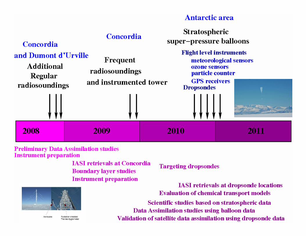
Experimental design
� Surface-based
o extra radiosoundings at Concordia (Dome C), Dumont d’Urville and Rothera
o 45-m instrumented tower, snowfall and accumulation observations, BSRN data and HAMSTRAD radiometer at Concordia
o Ozonesondes over some Antarctica polar stations
� Stratospheric superpressure balloons with meteorological sensors, ozone sensors, particle counters, GPS receivers, driftsondes carryingdropsondes
� Modelling: global and fine-scale models, chemical-transport models
� .... and satellites !
5
The Concordiasi Project
6
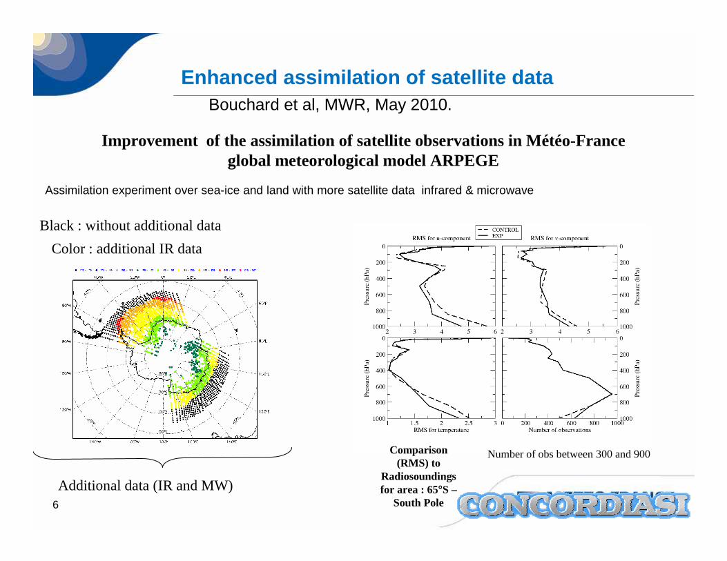
Improvement of the assimilation of satellite observations in Météo-France global meteorological model ARPEGE
Assimilation experiment over sea-ice and land with more satellite data infrared & microwave
Color : additional IR data
Additional data (IR and MW)
Number of obs between 300 and 900Comparison(RMS) to
Radiosoundings for area : 65°S –
South Pole
Enhanced assimilation of satellite dataBouchard et al, MWR, May 2010.
Black : without additional data

7
Assimilation experiment with more satellite data over sea-ice and Antarctica:
Obs – model for a period of 20 days duringaustral winter 2007
Obs : AIREP (airborne data) between 20°S and 50°S
Predictability studies, effects on lower latitudes
Improving assimilation over polar areas can also improve forecasts at lower latitudes
Bouchard et al, MWR, May 2010.

8
Data at Concordia
Time Period : from the 15 September 2008 to 30 November 2008 and 19 November 2009 to 13 December 2009
Observations: � 2008 : Radiosounding at DomeC (75°S ; 123°E) in order to have 2 observations
per day, at 0UTC and 12UTC. Complementary launch at the same time of IASI overpass.
� 2009 : As 2008 + Surface measurements (vertical profile of the snow temperature and BSRN data) at the time of the sounding.
Meteorological conditions : around 60% clear sky
� First outcome: models too warm at surface
An exceptional location to validate
satellite data assimilation

9
Model improvement
Statistics at Concordia and diagnostic of model performance: model too warm atSurface (C.Genthon, LGGE)
Lead to an improvement at ECMWF Change in albedo over permanent snow effective in 2008. Decreased warm bias(G. Balsamo, ECMWF)
before
after
difference

10
Work on snow modelling at Meteo-FranceImpact on IASI simulation over Antarctica
E. Brun, E. Bazile, V. Guidard
Histogram O-B for IASI surface channel 921 Cloudy channel diagnostic
In red, before snow modelling changes (albedo, roughness, thermal properties)
In blue and green, after changes: more data can be assimilated!

11
Current step: launching stratospheric balloons from Mc Murdo
Launch site:� Flattened area,� 2 Jamesways with
power, and some heating

12
Balloon system characteristics
18 superpressure balloons from CNES
All with meteorological sensorsat gondola level (temperature, pressure)
12 with driftsondes from NCAR (50 dropsondes in each)
6 with innovative instruments: ozone sensors, particle counters, GPS receivers
� Accurate wind speed forecast is a criticalissue for balloons launchings !

13
Launch preparation from McMurdo
CNES Courtesy

14
Lagrangian structures of the flow and data assimilation
Trajectories will be used to better understand the control exerted by the vortex on the motion of air parcels
(R. Mechoso, UCLA)
Use of the Concordiasi flight-level observations directly in the assimilation
(A. Tangborn, GMAO) Current past and forecasted trajectory of PSC16 balloon from September 11 to October 6

15
Dropsondes to calibrate the assimilation and for predictability studies
Localized singular vectors are computed at ECMWF(Alex Doerenbecher)Computed October the 3rd
for droppings the 4 th
Most of the sondes are dropped when coinciding MetOp overpasses
(calibration of IASI retrievals, validation of AVHRR winds..)
Part of the dropsondes are deployed in sensitive areas
�A unique test-bed for targeting in polar regions

16
Original targetting tools to optimize the launching of the dropsondes (A. Doerenbecher, Météo-France)
local time
Scheduled possible launches from 28 September 2010

17
Successful dropsondes on September the 28th.
O : dropsondes
O: radiosoundings

18
Real-time assimilation of balloonsobservations and dropsondes
(ECMWF)

19
Ozone depletion, polar stratospheric clouds and stratospheric dynamics
Interannual variability of ozone depletion depends on the activity of stratospheric waves and the presence of polar stratospheric clouds
Documentation of ozone loss along trajectories with meteorological
(P, T, Wind), chemical (Ozone) and microphysical observations.
(A. Hertzog, T. Desher, L. Avallone)
Validation of Chemical-Transport model
and Stratospheric ozone assimilation.
(L. El Amraoui)

20
Particle counter (T. Deshler, U. Wyoming)

21
Ozone depletion (L. Avallone, U. Colorado)Lagrangian real-time observations
���� Unique records of O3 loss rates

22
Ozone depletion (A. Hertzog, LMD)Lagrangian real-time observations
Colors: date since the launching of Balloon PSC16
� Concordiasi already got a unique lagrangian record of a total ozone depletion

23
GPS radio-occultation onboard one balloon(from J. Haase, Purdue University)
GPS radio occultation is used to obtain high-resolution atmospheric profiles of refractivity
Radio signals pass through the atmosphere from GPS satellite to GPS receiver
� As it travels, the signal encounters atmospheric layers of varying density
� The density changes cause the signal to refract and delay slightly
� A doppler shift is associated with the overall delay seen in the signal and can be converted into an atmospheric refractivity value at a geometrically determined tangent point to the Earth
r(tan)
TOA
GPSReceiver
GPSSatellite

24
Use of the detailed multi-layer snow model Crocusto study snow-atmosphere interactions over the Plateau
Radiative balance (short and long-wave)
turbulent fluxes (sensible and latent heat)
Snow /rain precipitation
Temperature
Density
Liquid Water content
Snow grains
Ground thermal fluxWater run-off
wind compaction

25
Dome C: a very convenient siteto study snow-atmosphere interactions
BSRN radiation station (ISAC-CNR)

26

27
Good performance of detailed snow models in off-line mode...
Input data from BSRN (ISAC-CNR) and LGGE
2010 January 20th. to 31st
Offline simulation with Crocus snow modelSurface Temperature : Observation from emitted LW

28
Reasonable simulation of snow surface temperature:fully coupled AROME/Crocus, 10-day simulation

29
... and realistic simulation of internal snow temperaturein coupled mode AROME/Crocus
-33 cm
-63 cm
-103 cm
Snow temperature observation by Laurent Arnaud (LGGE)
-23 cm

30
Outlook
Concordiasi 2008 and 2009 field campaigns: data hav e started to be used in studies over the Antarctic Plateau
���� improved assimilation of IASI and other sounders ov er snow and ice
���� improved snow scheme at ECMWF and Météo-France
Ongoing balloon campaign is already very successful :
In September-November:
- 600 dropsondes (already 87 )
- 18 balloons providing « AIREP-like » continuous data (already 11)
- already a unique record of lagrangian ozone deplet ion
- additional radiosoundings at Concordia, Dumont d’U rville and Rothera
� A unique data set :
- to calibrate/validate the assimilation of satellite data (sounders, polar winds…),
- to diagnose gravity-wave activity
- to better understand ozone depletion and quantify l oss rates
- to assess the potential of targeting in polar regio ns
- to study the extreme boundary-layer and snow-atmosp here interactions