the classical late weichselian climatic fluctuations … · li nche, 9 - cofre de perote, 10 - pico...
TRANSCRIPT

THE CLASSICAL LATE WEICHSELIAN CLIMATIC FLUCTUATIONS IN MEXICO
Klaus Heine
Regensburg University, FRG
INTRODUCTION
With respect to the c lass ica l Late Weichselian cl imatic f luctua-tions (Fig. 1) of the Netherlands and Western and Central Europe many sc ient ists t r ied to establish s imi lar chronostratigraphies of cl imatic variations for other parts of the world (e.g. Chi le, Western North America, New Zealand, South Antarctica). Recent investigations give more and more evidence that the c lass ica l West European chronostratigraphy of the Late Weichselian in many detai ls is a regional stratigraphy and cannot be transferred to other areas of the world.
Therefore i t is necessary to focus our attention on many different parts of the world, especially on the tropics and sub-tropics in order to establish a great number of seperate chronostratigraphies. I w i l l present here the results of investigations carried out during the last two decades in the central Mexican highland (Puebla/Tlaxcala area, Fig. 2) by many sc ient ists which were involved in the German-Mexican "Mexico Project" of the DEUTSCHE FORSCHUNGSGEMEINSCHAFT.
The conclusions concerning the Late Quaternary cl imatic history of the central Mexican highland are based on the results of research in geomorphology, tephrochronology, palaeopedology, and palaeoclimatology.
I. CHRONOLOGY OF GLACIAL DEPOSITS, EASTERN CORDILLERA NEOVOLVANICA, MEXICO
In many papers I have reported on the late Quaternary chrono-stratigraphic Situation of the central Mexican volcanoes
95
N.-A. MOmer and W. Karlen (eds.), Climatic Changes on a Yearly to Millennial Basis, 95-115. © 1984 by D. Reidel Publishing Company.

Z CS (0 C
o 2 s UJ a • § (0 u
ff £ UJ (— flä
• s w y I z *
3 8
2 UJ
O ü
u. "O
AL
:od: bo
• o IG
WARM PB
YD COLD YD
AL COOL
AL COOL
MD BO
MD
010 WARM
BO 010 COLD COLD
UD
HOLOCENE
NORTH BAY I.
VALDERS S.
TWOCREEK I.
VALDERS
T W O CREEK
Pt. HURON S.
MACKIN AW I. W 0 0 0 -FORD
Pt. BRUCE S.
EERIE I.
NISSOURI S.
Fig. 1: Chronostratigraphy of the Late Weichselian according to various sources. PB - Preboreal; YD - Younger Dryas; AL - Allerjzid; OD - Ol der Dryas; MD - Middle Dryas; BO - Böll ing; I. - Interstadia l ; ÄG - Ägard; LB - Low Ba l t i c ; Vi - Vintapper; OLD - Ol dest Dryas; UD - Upper Dryas; S. - Stadial
(Heine, 1975, 1978, 1980, 1983, in press). Volcanoes of the Cor-d i l l e r a Neovolcänica with late Quaternary g lac ia l deposits are shown in Fig. 2. Intensive investigations concerning the g lac ia l history of the volcanoes numbered 2 to 10 (Fig. 2) were carried out during 1971 - 1975. A summary of the palaeogeographic recon-struction of the eastern Cordi l lera Neovolcänica area for the time 40,000 yr BP to present is presented in Fig. 3.
The area of investigation comprises the eastern part of the volcanic belt (Cordi l lera Neovolcänica) that is composed of ero-ded Täte Tertiary and Quaternary volcanic and sedimentary rocks and extends for nearly 1000 kms along the 19th paral le l north. The huge volcanic massifs constitute barriers which separate the Valleys or basins from each other. Principal geographic features include f ive volcanic massifs (from west to east: Nevado de Toluca, Ajusco, Sierra Nevada with Popocatepetl, Iztaccihuat l , Tläloc and Telapön, Malinche, and Pico de Orizaba with Cofre de Perote) and four basins (basin of Toluca, basin of Mexico, basin of Puebla/Tlaxcala, and basin of El Seco/Oriental). The eleva-tions of the basins ränge from about 2200 to 2600 m, whereas the

Fig. 2 : Index map of the Cordi l lera Neovolcänica, Mexico. C i rc -les indicate the location of the volcanoes: 1 - Nevado de Colima, 2 - Nevado de Toluca, 3 - Ajusco, 4 - Tläloc, 5 - Telapön, 6 - Iztaccihuatl , 7 - Popocatepetl, 8 - Mal i nche, 9 - Cofre de Perote, 10 - Pico de Orizaba, 11 - Cerro Pefia Nevada, 12 - Durango mountaneous area, 13 - Tacanä, 14 - Tajumulco.
peaks of the volcanoes have heights between 3952 m (Ajusco) and 5700 m (Pico de Orizaba).
Different Täte Quaternary stratigraphic successions can be recognized within the area. The slopes of the volcanoes are d i s -sected by barrancas (erosion gu l l i e s ) , radiating from the upper parts of the forest belt and descending to the basins. Thus the stratigraphic successions can easi ly be traced from one barranca to the other by the different layers of g lac ia l and per ig lac ia l deposits, palaeosols, debris, f l u v i a l gravels and sands, and loess- l ike so-called "toba , l-sediments which are interbedded with tephra, lava flows, and ignimbrite deposits. The term "tephra" pertains to a l l pyroclastic fragments, such as f ine and coarse ash, l a p i l l i , volcanic bombs, and blocks.
Different tephra layers as well as some palaeosols are of great use as stratigraphic markers within the late Quaternary deposits of the volcanoes. In determining the stratigraphic succes-sion of tephra, both f i e l d characterist ics and laboratory exa-mination were carried out. Radiocarbon dating of tephra layers has been restr icted to charcoal logs and branches imbedded in the

Fig. 3: Scheme of three-dimensional development of the natural environment of the central Mexican highland during the Late Quaternary.

volcanic deposits. Many samples from charcoal were dated by M.A. Geyh. In addition to these data palaeosols, wood fragments from gravels, peat, and calcrete (caliche) deposits were dated by radiocarbon. Other age determinations of the late Quaternary deposits are being attempted through studies in archaeology and prehistory. Pollen studies in cores of Sediments in small volcanic craters,maars, and lakes (Ohngemach & Straka, 1983) cover the time span of approximately 35,000 to 0 yr BP. The results are compared with the chronology of the glacial. deposits. Furthermo-re, re lat ive age-dating methods have been used to demonstrate age differences in the t i l i sequence; such re lat ive dating methods include topographic posit ion, morphologic shape of the moraines, rock-weathering parameters, thickness of aeolian "toba"-sedi-ments, so i l properties, and Vegetation cover (including liehen data of Holocene g lac ia l and per ig lac ia l deposits).
A scheme of the three-dimensional development of the natural environment of the central Mexican highland during the late Quaternary is given in Fig. 3. Periods of normal and of catastro-phic processes, s t a b i l i t y , and erosion during the past 36,000 yr BP are immediately recognizable. The processes which are control-led by the biocl imatic milieu create d i s t inet ive so i l s and land-forms. Düring the past 36,000 yr BP three major periods with c l i -matically induced high erosion intens it ies and glacier advances can be distinguished: ( i ) 36,000 to >32,000 y r BP, ( i i ) around 12,000 yr BP, and ( i i i ) 10,000 to 8,500 yr BP. These periods with high erosion intens it ies and glacier advances coincide with c l i matic changes from relat ive a r id i ty to greater humidity. Figure 3 shows that there is no synchroneous development of the trend of the temperature on the one hand and of the trend of the humidity on the other hand. The temperature curve for the last 36,000 yr BP is marked in the tropics of the central Mexican highland by an increase between 36,000 and 32,000 yr BP, a decrease between ca. 26,000 and ca. 16,000 yr BP (with the last g lac ia l temperature minimum around 17,000 - 16,000 yr BP), and an increase of the temperature with minor fluetuations during the period 16,000 to 8,000 yr BP. The postglacial cl imatic Optimum is reached 8,000 to 5,000 yr BP. During the Holocene, only between ca. 2,000 and 3,000 yr BP the climate was s l i gh t l y cooler and wetter, producing a minor glacier advance.
Chronology of Late Weichselian Glacial Deposits
The chronology of the Late Weichselian g lac ia l deposits is best known at the Malinche volcano. There, most of the late g lacia l t i l l s are related to volcanic rocks and tephra as well as to or-ganic materials that can be dated by radiocarbon. By means of tephrochronologic methods val ley-to-val ley correlation of t i l l s is possible. The general d istr ibut ion and dimensions of the late Quaternary glaciers of the Malinche volcano and problems associa-ted with the ident i f i cat ion and d i f ferent iat ion of each glacier

advance and their age relationship were discussed by the author in previous papers (Heine, 1975, 1978, 1980, 1983 ). T i l l s with poorly preserved moraine forms are those of the M I-glacier advance between 36,000 and >32,000 yr BP and of t i l l s deposited during the M I I -g laciat ion about 12,000 yr BP. Lateral and end moraines deposited during the M I l l - g l ac i a t i oh between 10,000 and 8,500 yr BP show well preserved morainal forms, so do the Holocene neoglacial deposits which are d i v i s i b le into two advances (M IV: 2000 - 3000 yr BP; M V: L i t t l e Ice Age). A map of the sum-mit area of the Malinche volcano with the locations of the pr in-cipal g lac ia l and per ig lac ia l deposits is presented in Fig. 4. An outline of the local stratigraphy of the g lacia l deposits at the eastern slopes of the Malinche volcano (Fig. 5), based mainly on palaeosols ( fBol, fBo2, fBo3) and tephra layers (marker horizon
Fig. 4: Geomorphological map of the Malinche summit area. 1 - Talus debris, 2 - slope with volcanic s.ands, 3 - rock g lac ier, 4 - M IV-rock g lac ier, 5 - M III 3-moraine, 6 -M III 2- and M III 1-moraine, 7 - U-shaped Valley, 8 -rock, 9 - crest, 10 - crater (age in 14C years BP), 11 -gravel, 12 - s o l i f l u c t i on terracette, 13 - turf ex fo l i a -t ion, 14 - upper timber l ine (ca. 3900 - 4000 m), 15 -Valley, barranca, 16 - edge versus Valley.

CLASSICAL LATE WEICHSELIAN CLIMATIC FLUCTUATIONS IN MEXICO
4461m
5 (rock debris) Shoulders
u m . . • ^--volcanicsands M IV rock glacier—3^^—4150m
l280(W-1912f -3950m
fc--7450i250(W-1923r
7405 ±145 (Hv4757)-r:
76901100 (Hv4758)-^
7645 t 80(Hv4243). 77151 80(Hv4884)~i:
12060! 165 (Hv4244 £ 20735±460 (Hv4245" 81101300 W-1927
23940H000(W-19O3 25920110001W-1911 ; 17350t 550IW-1913 P-
3889511200 (Hv4241)
82401300(W-1909)#
M III 2 moraine 2970m M llllmoraine
1̂76501550(W-1925f
_2750m
Fig. 5: Scheme of the stratigraphy of the Late Quaternary depos i t s at the eastern slopes of the Malinche volcano. The
14C dates marked with stars refer to the western flank of the volcano.
rB), provide suf f ic ient Information of how different late Quaternary stratigraphic successions have been elaborated.
From the other volcanoes of the Cordi l lera Neovolcänica, deposits belonging to the major glaciations of the late Quaternary are described in detai l by Heine (1975). Figures 6 to 8 give ev i -dence of the location of the glacia l and per ig lac ia l deposits on Pico de Orizaba, the southern part of Iztaccihuatl, and the Nevado de Toluca volcano. Comparable to the late Quaternary s t r a t i graphic successions of the Malinche volcano are the glacia l deposits of these other volcanoes. Apart from the M I I -g laciat ion that did not exist at the Nevado de Toluca volcano (see Heine, 1983), f ive glacier advances of the late Quaternary can be t r a -ced on the slopes of Pico de Orizaba and Iztaccihuatl , whereas on the flanks of the less high volcanoes of Nevado de Toluca and Malinche the Holocene glacia l deposits of the M IV and M V phase do not occur. Instead of the g lac ia l deposits per ig lac ia l forms and deposits developed here (rock g lac iers, ice-cored moraines, rock debris).
In the correlation diagramm (Fig. 9) most geologic-climatic unit boundaries are based either on maximum or minimum radiocarbon dates or on re lat ive c r i t e r i a . In most cases radiometric con-tro l s are very re l iab le and the presented boundaries w i l l l i k e l y

not be shifted on the time bar.
The Period about 16,000 to 12,000 yr BP
During the period of 16,000 to 12,000 yr BP there were no major glacier advances on the central Mexican volcanoes. The so i l deve-
K HEINE 1975. ergänzt 1982

lopment of the palaeosol fBol terminated about 16,000 yr BP according to radiocarbon dates of charcial from pumice layers
Fig. 7: Geomorphological map of the southern part of the I z tacc i -huatl massif. 1 - g lac ier , 2 - M V-moraine, 3 - cirque, 4 - U-shaped Valley, 5 - str iated ground, 6 - röche mou-tonee, 7 - crest, 8 - upper timber l i n e , 9 - brook (periodic).
Fig. 6: Geomorphological map of the Pico de Orizaba. 1 - g lac ier , 2 - f o s s i l ice beneath debris, 3 - M V-moraine, 4 - M IV-moraine, 5 - M III 3-moraine, 6 - M III 2- and M III 1-moraine, 7 - cirque, 8 - U-shaped val ley, 9 - röche mou-tonee, 10 - ice-free crest during maximum g lac iat ion, 11 - rock glacier ( L i t t l e Ice Age), 12 - str iated blocks on moraine, 13 - t a l u s , 14-debris flows, 15-thufur, 16-crater, 17 - steep wal l s , 18 - lava flow, 19 - crest, 20 - val ley, barranca, 21 - edge versus va l ley, 22 - Upper timber l ine (ca. 4000 m), 23 - well with brook, 24 -path.

covering the Ah-horizon of the palaeosol fBo l . No traces of erosion on the slopes of the volcanoes are v i s i b l e . If the preser-vation of the topsoil of the palaeosol fBol during the period 16,000 to 12,000 yr BP is taken to be an evidence for re la t i ve ly weak erosion and denudation on the mountain f lanks, then the c l i -mate must have been re lat i ve ly dry and cool compared with today.

MV
MIV
1 fBo2 Mll
fBol
M
1 j Radiocarbon dates $ valsequillo area + RioFroPass x Malinche volcano O Iztacclhuatl, Popocatepetl • Nevado äe Toluca volcano A El Seco/Oriental area • Tlaxcala area
• Daring by archaeology, historical sources
L j Radiocarbon dates
$ valsequillo area + RioFroPass x Malinche volcano O Iztacclhuatl, Popocatepetl • Nevado äe Toluca volcano A El Seco/Oriental area • Tlaxcala area
• Daring by archaeology, historical sources
|
Radiocarbon dates $ valsequillo area + RioFroPass x Malinche volcano O Iztacclhuatl, Popocatepetl • Nevado äe Toluca volcano A El Seco/Oriental area • Tlaxcala area
• Daring by archaeology, historical sources
RH j
Radiocarbon dates $ valsequillo area + RioFroPass x Malinche volcano O Iztacclhuatl, Popocatepetl • Nevado äe Toluca volcano A El Seco/Oriental area • Tlaxcala area
• Daring by archaeology, historical sources
X • O XX 1
Radiocarbon dates $ valsequillo area + RioFroPass x Malinche volcano O Iztacclhuatl, Popocatepetl • Nevado äe Toluca volcano A El Seco/Oriental area • Tlaxcala area
• Daring by archaeology, historical sources
e x » !
Radiocarbon dates $ valsequillo area + RioFroPass x Malinche volcano O Iztacclhuatl, Popocatepetl • Nevado äe Toluca volcano A El Seco/Oriental area • Tlaxcala area
• Daring by archaeology, historical sources •
Radiocarbon dates $ valsequillo area + RioFroPass x Malinche volcano O Iztacclhuatl, Popocatepetl • Nevado äe Toluca volcano A El Seco/Oriental area • Tlaxcala area
• Daring by archaeology, historical sources
c
r i
i l V
u j A
X X
j X A
1 1 •1 1
1 2 3 ^ 5 6 7 8 1 9 1 D 11 12 13 % 1 5 2 D 25 3 0 3
Pinus/Mixed forest Abies Pinus/Mixed forest ö
x103yrBP
iiiniii cold irrm cool
more humid DXO more arid H-t-H alternating more humid - more arid
Fig. 9: Correlation diagram. Geologic-climatic unit boundaries are based on radiocarbon ages, tephrochronologic correla-t ions, so i l development, pollenanalyses, sedimentologic c r i t e r i a , and topographic posit ion. The pollen zones re-fer to Ohngemach & Straka (1983).
Fig. 8: Geomorphological map of the Nevado de Toluca volcano. 1 - ta lus, 2 - 'Glatthang' (straight smooth slope), 3 -rock glacier (phase I ) , 4 - rock glacier (phase I ) , 5 -rock glacier (phase I I ), 6 - rock glacier (phase I I I ) , 7 - Valleys in debris, 8 - debris flow, 9 - debris flow lobe, 10 - M III-moraine, 11 - M III-moraine, not c lear ly ident i f ied , 12 - U-shaped val ley, 13 - t i l i , 14 - röche moutonee, 15 - rock, 16 - volcanic plug, 17 - crest, 18 -val ley, barranca, 19 - upper timber l ine (ca. 4000 m), 20 - crater lake, 21 - dry lake, 22 - road, 23 - hut with a lt i tude in meter.

Relative dry conditions are indicated by the preservation of the palaeosol fBo l . Relative cool conditions are indicated by the termination of the development of the palaeosol fBo l , because the so i l formation and the so i l properties only depend on climate and alt i tude (Miehlich, 1974). It is s igni f icant that the period 16,000 to 12,000 yr BP is not represented by any radiocarbon date obtained from deposits of the slopes of the volcanoes (Fig. 9).
The M I I-Glacier Advance at about 12,100 yr BP
The M I I -g lacier advance occured around 12,100 yr BP, but only on the high volcanoes east of the basin of Mexico M II-moraines ex-tend down to lowest elevations of less than 2750 m in huge Valleys of the Malinche and Pico de Orizaba. Above 3000 to 3300 m they are covered by a mantle of volcanic tephra, debris, and younger g lac ia l and per ig lac ia l deposits, so that the erosion of the barrancas do not reach the M II-morainic material; therefore nothing is known about the upper l im i t of M I l - t i l l s on the moun-tain slopes. The M I I -g lac ia l episode is characterized by a short duration of presumably less than 200 years according to inves t i gations of the moraines and other g l a c i a l , pe r i g l ac i a l , and f l u -v ia l Sediments (Heine, 1983). The M I I -g lacier advance was caused by intense precipitat ion rather than by a temperature decrease. This increase in precipitat ion has been observed in various Sediments from sites of the Sierra Nevada, the Malinche, and the Pico de Orizaba. It is not represented by any deposits east of the basin of Mexico, e.g. at the Nevado de Toluca, which I believe marks the influence of the Gulf of Mexico in respect to the short but intense increase in precipitat ion around 12,100 yr BP.
The Period from 12,000 to 10,000 yr BP
The period between about 12,000 and 10,000 yr BP is characterized by so i l formation on the slopes of the high volcanoes. The palaeosol fBo2 was developed. According to the a l t i tud ina l belt of the formation of the palaeosol fBo2 the climate must have been re lat i ve ly cool compared with today.
The M I I I -Glacier Advances between 10,000 and 8,500 yr BP
During the period between 10,000 and about 8,500 yr BP the com-plex of the M III-moraines were formed. The f i r s t and second advances of the M I I I -g laciat ion led to the formation of huge lateral and end moraines (see Fig. 4 - 8 ) . These moraines extend from below the present tree l ine about 4000 m down to around 2900 m ( f i r s t advance: M III 1) and 3000 m (second advance: M III 2) re-spectively. Recessional moraines of the M I I I -g laciat ion (M III 3) are found at about 4000 m alt i tude at the Malinche, whereas moraines of this advance reach farther downvalley on the fTanks of the Sierra Nevada and the Pico de Orizaba, because of the
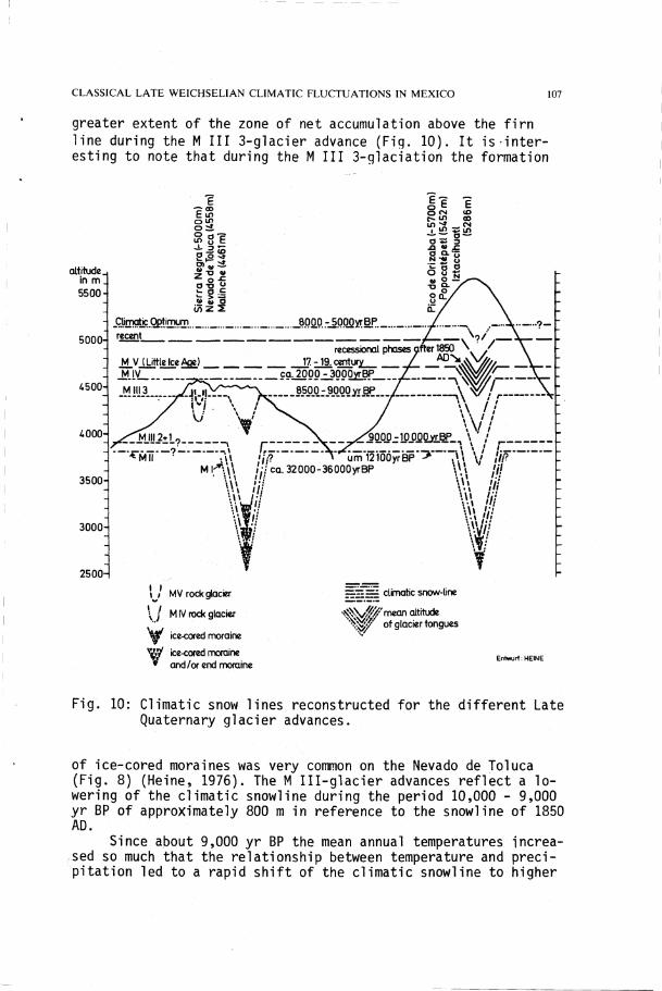
greater extent of the zone of net accumulation above the f i r n l ine during the M III 3-glacier advance (Fig. 10). It i s i n t e r -esting to note that during the M III 3-glaciation the formation
altrtude. in m 5500
5000-
4500-
4000-
3500«
3000-
2500-
6 -p CD E in o m o : £ 2 1 1
£ o <7) Z 2
Jri'niQl!c
„Qßt.'!IHr. recent
ÖOMr^POOyrBP. ._ ,
M V (LiffleIceAqe) recessional phases <
J7. -19. Century
_M IV ca .2000-300ÖyrBP f 8500-9000yrBP /
\ \ A x5QP0-10QfiQ>iBP_ \ •
\>.\
um 12100yrBP 36000yrBP Vi
\\\
f
iii
Ii Iii
\ ! MV rock glacier
\ / MIV rock glacier
^ ice-cored moraine
T ice-cored moraine and/or end moraine
climatic snow-line
•^Ns/^'mean altitude ^ 7 °* 9 , a c i e r tongues
Entwurf: HEINE
Fig. 10: Climatic snow lines reconstructed for the different Late Quaternary glacier advances.
of ice-cored moraines was very common on the Nevado de Toluca (Fig. 8) (Heine, 1976). The M I I I -g lacier advances re f lect a l o -wering of the cl imatic snowline during the period 10,000 - 9,000 yr BP of approximately 800 m in reference to the snowline of 1850 AD.
Sinee about 9,000 yr BP the mean annual temperatures increa-sed so much that the relationship between temperature and prec i pitat ion led to a rapid sh i f t of the cl imatic snowline to higher

elevations. Only a few recessional moraines give evidence of minor gläcier fluctuations during the period 9,000 to 8,500 yr BP.
The Period from 8,500 to 5,000 yr BP
The rapid deglaciation temrinated ca. 8,500 yr BP. According to the radiocarbon dates of the palaeosol fBo3 that developed either on the M- I I I - t i l l s and/or on volcanic tephra of post-Pleistocene age (Fig. 5) the period between 8,000 and 5,000 yr BP was s l i gh t -ly warmer than recent times; the development of andosols took place even in areas up to 4200 m alt i tude (today andosol development is restr icted by low temperatures over 4000 m a l t i tude) . The postglacial c l imatic Optimum is documented in the central Mexican highland by the palaeosol fBo3.
The Period from 5,000 yr BP to Recent Times
During the last 5,000 years, two periods with glacier advances occurred. The M IV-glaciation is dated to about 2,000 to 3,000 yr BP. A minor glaciation can be correlated with the L i t t l e Ice Age. Since about 1850 AD to 1972, the ice caps and glaciers of the Iztaccihuatl , Popocatepetl, and Pico de Orizaba were reduced to small remnants of ice (Heine, 1983b).
Palynologic Analyses
Palynologic, sedimentary, and radiocarbon analyses of gyt t ja , clay, sand, ash, lake marl, and other deposits, formed in small craters and maars, provide a palaeoenvironmental and palaeocl i -matic record of approximately 35,000 yr BP for the eastern Cor-d i l l e r a Neovolcänica (Ohngemach & Straka, 1983; Heine & Ohnge-mach, 1976). Of special interest is a pollen sequence of the T la-loqua crater which is situated at an a lt i tude of about 3100 m on the western slope of the Malinche volcano (Fig. 11).
During the M I I I -g laciat ion (lower part of the diagram, Fig. 11) the upper zone of the forest certainly consisted of pines just as today, for pine pollen mostly accounts for more than 80 % of the pollen during the time rieh in NAP. Ainus and Quercus play a comparatively minor part (Ohngemach 1977). Of part icular inter est is the occurrence of Picea, a genus encountered in Mexico today only at a few r e l i c t stations. The nearest s i te of Picea c h i -huahuana is situated 900 km north-west of the Malinche volcano, picea mexicana is found some 700 km to the north. The pollen of picea occurs below about 2 m in every sample, above the 2 m l e -ve l , Picea is no longer found. The extinetion of Picea coincides with the rapid decrease of the NAP curve (Ohngemach, 1977). According to Heine (1975, 1980, 1983a; see Fig. 3) the climate was cooler and more humid than today during the M I I I -g lac ia l advances. Such a climate may have been the precondition for the former presence of spruce at the Malinche volcano and the basin of El

Fig. 11: Pollen diagram of the Pleistocene/Holocene boundary at the Malinche volcano, Mexico (after Heine & Ohngemach, 1976 and Ohngemach & Straka, 1983).
Seco/Oriental (Ohngemach & Straka, 1983). When the climate became drier and warmer after the M I I I -g lac iat ion, Picea was not able to persist any longer and dies out (Ohngemach, 1977; Heine & Ohngemach, 1976). The level marked by the extinction of Picea is t a -ken as the boundary between Pleistocene and Holocene Vegetation. Provided that the diagram (Fig. 11) S t a r t s shortly after the be-ginning of M I I I -g laciat ion at 10,000 yr BP, one reaches an age of some 8,500 yr BP for this t rans i t ion, i f one takes further i n -to account a radiocarbon date (ca. 8,000 yr BP) for the Ainus ma-ximum at 1.7 m together with the supposition of a constant Sedimentation rate (Ohngemach 1977). This agrees well with the f i x a -tion of the Pleistocene/Holocene boundary based on geomorpholo-g ic, palaeopedologic, and palaeontologic evidence (Heine & Ohngemach, 1976).
The region around the Tlaloqua crater was only a t rans i t Station to higher elevations for the Pinus hartwegii forest that succeeded the late Weichselian alpine grassland after about 8,500 yr BP (see also Fig. 9). Ohngemach (1977) and Ohngemach & Straka (1983) infer the presence of Pinus hartwegii from the occurrence

O f the parasite Arceuthobium globosum S S p . graudicaule by which Pinus hartwegii is preferably infected.
According to the pollen diagrams of Ohngemach & Straka (1983) no not ic ib le deterioration in temperature occurred during the Late Weichselian and early Holocene trend of warming (16,000 to 8,000 yr BP). On the other hand, the M I-glaciat ion, the M I I I -g lacier advances, and the M IV-glaciation are well recorded in the pollen diagrams.
II. PALAEOCLIMATIC INTERPRETATION
In the central Mexican highland, the Late Weichselian (ca. 16,000 to 8,500 yr BP) is characterized by increasing temperatures with-out the well-known sudden deteriorations of temperature during the 01 der and Younger Dryas periods. Apart from the 12,000 yr BP event (Heine, 1983a) that seems to be triggered by an enormeous increase in precipitat ion rates mainly in the regions facing the Gulf of Mexico-coast, only the period 10,000 to 8,500 yr BP shows cl imatic conditions favorable for greater glaciations on the high mountains. This Late Weichselian cl imatic f luctuation is caused by higher precipitat ion during a period with increasing temperatures between the re lat i ve ly cold phase of oxygen isotope stage 2 and the warm postglacial c l imatic Optimum of oxygen isotope stage 1. The palynologic evidence indicates, too, that the M e i -stocene/Holocene boundary is dated to about 8,500 yr BP in the central Mexican Highland. Different pollen diagrams from the area prove that no abrupt cl imatic fluctuations in temperature com-parable to the Older and Younger Dryas periods occurred. Even the 12,000 yr BP event cannot be traced in the pollen diagrams, pre-sumably because of the Short duration of the 12,000 yr BP event of less than 200 years (Heine, 1983a).
The c lass ica l Late Weichselian c l imatic fluctuations of the central Mexican highland are ( i ) with respect to the temperature; increasing temperatures without any major variations and/or abrupt f luctuations, and ( i i ) with respect to the prec ip i tat ion: a short but great increase of precipitat ion about 12,000 yr BP and a period with higher precipitat ion between 10,000 and 8,500 yr BP. Yet, unt i l today we cannot estimate the absolute amount of precipitat ion during the various Late Weichselian glaciat ions. The pollen studies show that the Late Weichselian fluctuations in precipitat ion in the basins must have been of no s ign i f icant i n -fluence for the Vegetation. We might conclude, because of t h i s , and because of the shrinkage of the glaciers since the L i t t l e Ice Age maximum glacier extent in 1850 AD that took place without any s ign i f icant variations in temperature and/or prec io i tat ion, that the Late Weichselian glaciations were due to only s l i gh t l y a l t e red conditions in humidity.

III. CORRELATION WITH LATE QUATERNARY EVENTS IN OTHER REGIONS
The Täte Quaternary environmental history of Lake Valencia/Venezuela (Bradbury et a l . , 1981) obtained by chemical, palaeontolo-g i c a l , and mineralogical analyses of a 7.5 m core from the lake allows a tentative correlation with the Situation in central Mexico. The data show that dry climates existed in the Lake Valencia region from at least 13,000 yr BP (= the base of the core) unt i l about 10,000 yr BP. The Lake Valencia Basin was occupied by intermittent saline marshes at that time. Düring the period 13,000 to 10,000 yr BP only the pöllen record gives evidence for a minor increase in moisture by a small amount of arboreal pollen [spondias and Bursera) at a depth of 6.4 m (Bradbury et a l . , 1981). If one takes into account a constant Sedimentation rate of the 13,000 to 10,000 yr BP deposits, the increase in moisture in what otherwise was an arid c l imatic period can be compared to the M I I -g laciat ion of Mexico. About 10,000 yr BP, a permanent Lake Valencia of f luctuating s a l i n i t y formed and arboreal plant commu-nit ies replaced the ear l i e r dominant xeric herbaceous Vegetation and marsh plants. This zone 2 of the Lake Valencia core correla-tes with the M I I I -g laciat ion period of central Mexico. By 8,500 yr BP, Lake Valencia reached moderate to low s a l i n i t i e s and d is -charged water; the modern Vegetation became established at that time. After 8,500 yr BP, the lake twice ceased discharging as a result of reduced watershed moisture (Bradbury et a l . , 1981). The stratigraphic record from Lake Valencia is important because i t contains a continuous, well-dated, and wel1-documented palaeo-environmental history of a löw-latitude, low elevation s i te from the late Pleistocene to the present. Table 1 is a tentative correlat ion of palaeoenvironmental interpretations from the Lake Valencia record with the Mexican data.
The most important conclusions from Table 1 are the co inc i -dence of the central Mexican late Quaternary chronostratigraohy
Central Mexico tNspaper
Lake Valencia Bradbury etat. 1981
m'v
zone 3 SKTBiar TOTnaT
of today
MIV
zone 3 SKTBiar TOTnaT
of today
zone 3 SKTBiar TOTnaT
of today
Mllt zone 2 Humid
zone 1 Mae^than
Morearid than today
zone 1 ? ? ?
Mae^than
Morearid than today
Table 1: Tentative correlation of palaeoenvironmental interpretations from the Lake Valencia record with the Mexican data
with the Lake Valencia core and the evidence that the Younger Dryas period did not ex i s t , neither in Mexico nor in Venezuela.

The stratigraphic records from Mexico and Venezuela cannot be correlated with late Quaternary glaciations in Central and South America; the principal d i f f i c u l t y is the lack of adequate radiocarbon time control in most studies (Bradbury et a l . , 1981; Heine, 1975, 1983c). According to Mercer (1983), in the South American tropics, interpretations of past variations of glaciers in terms of climate is d i f f i c u l t ; owing to the intensity of solar radiation year-round, the glaciers are very sensitive to changes in cloudiness and albedo of the glacier surface. Mercer (1983) reports that in Peru by 12,200 yr BP the Quelccaya Icecap was not much 1 arger than i t is today and that a later readvance that was in progress soon after 11,500 yr BP culminated after 11,000 yr BP. The icecap then shrank rapidly and shortly after 10,000 yr BP was l i t t l e or no larger than i t is today. The dating of the readvance after 11,500 yr BP suggests that i t preceded the European Younger Dryas Stade by a few centuries, but i t does not pre-clude the pos s ib i l i t y that they were simultaneous (Mercer, 1983). In southern South America no g lac ia l geological evidence has been found anywhere for a readvance at the time of the Younger Dryas period (Mercer, 1983), although severe cooling and a r i se in prec ip i ta t ion have been inferred from the pollen record (Heusser et. a l . , 1981). The analyses of f o s s i l beetle assemblages through the Late Glacial of southern Chile implies a re lat ive stable climate, too, and does not support, l i ke the geomorphological evidence, the assumption of a major cl imatic deterioration about the same time as the Younger Dryas in Europe (Ashworth & Hoqan-son, 1983).
IV. C0NCLUSI0NS
The palaeonvironmental data from Mexico, Venezuela, and Chile support the hypothesis that Late Weichselian climates in the t ro pics of America were more arid than today. The c lass ica l Late Weichselian cl imatic fluctuations of the 01 der and Younger Dryas periods did not occur. There is evidence that these Late Weichsel ian c l imatic deteriorations are best documented in Scandinavia (Berglund et a l . , 1983; Berglund & Mörner, 1983) although even for middle Sweden Björck & Digerfeldt (1983) postulate that either many s ign i f icant events occurred during Younger Dryas or hardly nothing at a l l , perhaps not even the 'famous' drainage of the Ba l t i c Ice Lake at the northern point of Mt. B i l l ingen. If we move away from Scandinavia to the Alps then the 01 der Dryas near-ly disappers (de Beaulieu et a l . , 1983; Ammann et a l . , 1983) and the Younger Dryas cooling cannot have been very strong (Ammann et a l . , 1983). Observations from the Alps and Switzerland show that the Older Dryas Stade can only be traced by 'reworked mater ial ' and not by pollen evidence (de Beaulieu et a l . , 1983) or as a somewhat "drier phase1 (Ammann et a l . , 1983). In the Alps, the Younger Dryas was more pronounced by palaeoenvironmental changes

at greater heights, whereas on the Swiss Plateau the Younger Dryas cl imatic deterioration was less severe.
From the ' t rop ica! point of view' we should not only look for evidence for the Ol der and Younger Dryas Stades, but also for evidence for the non-existence of these cl imatic f luctua-tions. The low-latitude stratigraphies experience a Late Weichsel ian trans it ion from füll g lac ia l dry and cold/cool climate to postglacial conditions without s ign i f icant cold temperature anomal i es.
ACKNOWLEDGEMENTS
The author is grateful to M. A. Geyh for radiocarbon age determi-nations, H. Heide-Weise for mineralogical analyses, and the DEUTSCHE FORSCHUNGSGEMEINSCHAFT for f inancial support.
REFERENCES
Ammann, B., Chaix, L., Eicher, U., E l i a s , S., Ga i l l a rd , M.-J., Hofmann, W., Siegenthaler, U., Tobolski, K. & Wilkinson, B., 1983. Vegetation, insects, molluscs and oxygen isotopes in Late-Würm deposits at Lobsigensee (Swiss Plateau). Abstracts 2nd Nordic Symp., Stockholm May 16 - 20, 1983, Danish Meteor. Inst., Kopenhagn, pp. 2-3.
Ashworth, A. C. & Höganson, J . W., 1983. Was there a cl imatic change in southern Chile about the same time as the Younger Dryas in Europe? Abstracts Intern. Symp. on Late Cainozoic Palaeoclimates of the Southern Hemisphere, Swaziland 29 Aug. - 2 Sept. 1983, p. 31.
Beard, J . H., 1973. Pleistocene-Holocene Boundary and Wisconsinan Substages, Gulf of Mexico. Geol. Soc. amer. Memoir, 136, 277-316.
Berglund, B. E., Dearing, J . , Lemdahl, G., Liedberg-Jönsson, B. & Persson, T., 1983. The Kullen Peninsula in SW Sweden - a palaeoecological reference s i te for Late Weichselian. Abstracts 2nd Nordic Symp., Stockholm May 16 - 20, 1983, Danish Meteor. Inst., Kopenhagn, pp. 14-15.
Berglund, B. E. & Mörner, N.-A., 1983. Late Weichselian deglacia-tion and chronostratigraphy of Southern Scandinavia: Problems and present "state of a r t " . Abstracts 2nd Nordic Symp., Stockholm May 16 - 20, 1983, Danish Meteor. Inst., Kopenhagn, pp. 9-13.
Björck, S. & Digerfeldt, G., 1983. Shore displacement and de-glaciat ion chronology around the boundary Pleistocene-Holocene in the Middle Swedish endmoraine zone. Abstracts, 2nd Nordic Symp., Stockholm May 16 - 20, 1983, Danish Meteor. Inst., Kopenhagn, pp. 17-19.
Björklund, K. R. & Göll, R. M., 1979. Ice Age Climates of the

Norwegian-Greenland Sea. GeoJournal, 3.3, 273-286. Bowen, D. Q., 1978. Quaternary Geology. A Stratigraphic Framework
for Mult id isc ip l inary Work. Oxford, pp. 1-221, Pergamon. Bradbury, J . P., Leyden, B., Salgado-Labouriau, M., Lewis, W. M.,
Schubert, C , Binford, M. W., Frey, D. G., Whitehead, D. R. & Weibezahn, F. H., 1981. Late Quaternary Environmental History of Lake Valencia, Venezuela. Science, 214, 1299-1305.
de Beaulieu, J . - L . , Clerc, J . & Re i l l e , M., 1983. Late Weichsel ian fluctuations in the French Alps and Massif Central from pollenanalyses. Abstracts, 2nd Nordic Symp., Stockholm May 16.- 20, 1983, Danish Meteor. Inst., Kopenhagn, p. 8.
Dreimanis, A., 1977. Late Wisconsin Glacial Retreat in the Great Lakes Region, North America. Ann. New York Acad. Sciences, 288, 70-89.
Evenson, E. B., Farrand, W. R., Eschmann, D. F., Mickelson, D. M. & Mäher, L. J . , 1976. Greatlakean Substage: A Replacement for Valderan Substage in the Lake Michigan Basin. Quaternary Research, 6, 411-424.
Heine, K., 1975. Studien zur jungquartären Glazialmorphologie mexikanischer Vulkane - mit einem Ausblick auf die Klimaentwicklung. Das Mexiko-Projekt der DFG VII, Wiesbaden, pp. 1-178, Steiner.
Heine, K., 1976. Blockgletscher- und Blockzungen-Generationen am Nevado de Toluca, Mexiko. Die Erde, 107, 330-352.
Heine, K., 1978. Neue Beobachtungen zur Chronostratigraphie der mittelwisconsinzeitl ichen Vergletscherungen und Böden mexikanischer Vulkane. E i s ze i ta l te r u. Gegenwart, 28, 139-147.
Heine, K., 1980. Quartäre Pluvialzeiten und klimamorphologischer Formenwandel in den Randtropen (Mexiko, Kalahari). Arb. Geogr. Inst. Univ. Saarland (Festschr. C. Rathjens), 29, 135-157.
Heine, K., 1983a. Ein aussergewöhnlicher Gletschervorstoss in Mexiko vor 12,000 Jahren. Ein Beitrag zum Problem der spätglazialen Klimaschwankungen. Catena, 10, 1-25.
Heine, K., 1983b. Mesoformen der Per ig laz ia lstufe der semihumiden Randtropen, dargestellt an Beispielen der Cordi l lera Neovol-cänica, Mexiko.~Abh. Akad. Wiss. Göttingen, Math.-Phys. K l . (in press).
Heine, K., 1983c. Führt die Quartärforschung zu n i ch t -ak tua l i s t i -schen Modell Vorstellungen in der Geomorphologie? Colloquium Geographicum, 16, 93-121.
Heine, K., in press. Spät- und postglaziale Gletscherschwankungen in Mexiko: Befunde und paläoklimatisehe Deutung. In: Late-and postglacial osc i l la t ions of g laciers: Glacial and per i -g lac ia l forms (ed. H. Schroeder-Lanz), in press, Balkema.
Heine, K. & Ohngemach, D., 1976. Die Pleistozän/Holozän-Grenze in Mexiko. Münster. Forsch. Geol. Paläont., 38/39, 229-251.
Heusser, C. J . , Streeter, S. S. & Stuiver, M., 1981. Temperature and precipitat ion record in southern Chile extended to

-43,000. yr ago. Nature, 294, 65-67. Mercer, J . H., 1983. Late Cainozoic Glacier Variations in South
America South of the Equator. Abstracts Intern. Symp. on Late Cainozoic Palaeoclimates of the Southern Hemisphere, Swaziland 29 Aug. - 2 Sept. 1983, pp. 19-21.
Mörner, N.-A., 1976. Paleoclimatic records from South Scandinavia, global correlations, or ig in and c y c l i c i t y . Paleolimnology of Lake Biwa and the Japanese Pleistocene, 4, (ed. S. Horie), pp. 499-528.
Miehlich, G,, 1974. Klima- und altersabhängige Bodenentwicklung von Vulkanascheböden der Sierra Nevada de Mexico. Mitt . Deutsch. Bodenkundl. Gesellsch., 18, 360-369.
Ohngemach, D., 1977. Pollen Sequence of the Tlaloqua Crater (La Malinche Volcano, Tlaxcala, Mexico). Bol. Soc. botan. Mexico, 36, 33-40.
Ohngemach, D. & Straka, H., 1983. Beiträge zur Vegetations- und Klimageschichte im Gebiet von Puebla-Tlaxcala. Pollenanaly-sen im Mexiko-Projekt. Das Mexiko-Projekt der DFG XVIII, Wiesbaden, pp. 1-161 + Suppl., Steiner.
Woil lard, G., 1975. Recherches palynologiques sur le Pleistocene dans l ' E s t de la Belgique et dans les Vosges Lorraines. Acta Geographica Lovanensia, 14, 1-168.