the city of seattle landmarks preservation board
TRANSCRIPT

The City of Seattle
Landmarks Preservation Board Mailing Address: PO Box 94649 Seattle, WA 98124-4649
Street Address: 600 4th Avenue, 4th Floor, Seattle, WA 98104
Landmark Nomination Form Name: Avalon Substation Year Built: 1954 Street and Number: 3243 SW Genesee St. Assessor’s File No.: 929730-1810 and 929730-1805 Block: 12 Plat Name: Westholme Addition Lot: 12 and 13 Legal Description: Lots 12 and 13, Block 12, Westholme Addition, according to the plat thereof recorded in
Volume 22 of Plats, page 51, in King County, Washington Present Owner: Seattle City Light Present Use: Decommissioned, storage Address: 700 5th Avenue, Suite 3200 P. O. Box 34023 Seattle, WA 98124-4023 Original Owner: Seattle City Light Original Use: Substation - Rectifier Architect: H. G. Silliman, Chief of Design Section Builder: C and R Builders Inc. Engineer: H. V. Strandberg and John M. Nelson Submitted by: Date: 3/28/17 Prepared by: Rebecca R. Ossa, Historic Resource Specialist/Architectural Historian Address: Seattle City Light – Environment, Land, and Licensing Business Unit P. O. Box 34023, Seattle, WA 98124-4023. Phone: 206-386-4519 Reviewed: Date: City Historic Preservation Officer
Administered by The Historic Preservation Program, Seattle, Department of Neighborhoods

Page 2 of 68
TABLE OF CONTENTS I. Introduction/Background ............................................................................................................ 5
Research Methodology ............................................................................................................................................... 5
II. Description – Avalon Substation ................................................................................................. 5
Generation, Transmission, and Distribution – A Substation’s Role ............................................................. 6
Architectural Styles in the 1930s-1960s ................................................................................................................ 8
Rectifier Substations and Rectifier Equipment within City Light (1939-1963) ........................................ 9
Table 1 – City Light’s Rectifier Substations (1939-1963) and Current Status/Notes ......................... 11
III. Statement of Significance ..........................................................................................................13
Brief History of West Seattle ................................................................................................................................. 13
Puget Mill Company’s Westholme Additions .................................................................................................. 15
History of Seattle City Light .................................................................................................................................... 18
Avalon Substation Development .......................................................................................................................... 24
IV. Photographs ................................................................................................................................30
Photo 1 – Avalon Substation in 1955. ................................................................................................................. 30
Photo 2 – Avalon Substation Yard in 1954 ....................................................................................................... 31
Photo 3a – Avalon Substation, Neighborhood Context Photo. ................................................................ 32
Photo 3b – Avalon Substation, Neighborhood Context Photo. ................................................................ 32
Photo 4 – Avalon Substation, Northwest Elevation. ...................................................................................... 33
Photo 5 – Avalon Substation, North Elevation. ............................................................................................... 33
Photo 6 – Avalon Substation, East Elevation. ................................................................................................... 34
Photo 7 – Avalon Substation, South Elevation. ............................................................................................... 34
Photo 8 – Avalon Substation, South Yard Area. .............................................................................................. 35
Photo 9 – Avalon Substation, West Elevation. ................................................................................................. 35
Photo 10 – Avalon Substation, Entry Door Detail .......................................................................................... 36
Photo 11 – Avalon Substation, East Metal Rollup Door Detail .................................................................. 36
Photo 12 – Avalon Substation, Interior from the North (Front) Door. ................................................... 36
Photos 13, 14 and 15 – Avalon Substation, Interior Details. ...................................................................... 37
Photo 16 – Leary Substation, Southeast Elevation. ........................................................................................ 38
Photo 17 – Leary Substation, South (Main) Entry ........................................................................................... 38
Photo 18 – Leary Substation, Main Entry Detail .............................................................................................. 38

Page 3 of 68
Photo 19 – North Substation, East Elevation ................................................................................................... 39
Photo 20 – North Substation, East Entry Porch and Double Door Details............................................ 39
Photo 21 – Olympic Substation, Northeast Elevation. .................................................................................. 40
Photo 22 – Olympic Substation, Entry Door (West Elevation) Detail ...................................................... 40
Photo 23 – Olympic Substation, East Porch Detail ........................................................................................ 40
Photo 24 – Roxbury Substation, West Elevation. ............................................................................................ 41
Photo 25 – Roxbury Substation, Northwest Elevation. ................................................................................. 41
Photo 26 – Roxbury Substation in 2000............................................................................................................. 42
Photo 27 – Roxbury Substation in 1956............................................................................................................. 42
Photo 28 – South Rectifier, East Elevation......................................................................................................... 43
Photo 29 – South Rectifier, North Elevation in 2014. .................................................................................... 43
Photo 30 – South Rectifier, North Elevation in 2000. .................................................................................... 43
Photo 31 – University Rectifier, Northeast Elevation ..................................................................................... 44
Photo 32 – University Rectifier 1952 Entry Door Detail ............................................................................... 44
Photo 33 – University Rectifier 1952 Light Fixture ......................................................................................... 44
Photo 35 – University Rectifier 1952 Rollup Door .......................................................................................... 45
V. Figures – Documents and Maps ...........................................................................................46
Figure 1 – Location Map for Avalon Substation within the City of Seattle. .......................................... 46
Figure 2 – Parcel Map (dated 2015) ..................................................................................................................... 47
Figure 3 – Map of Avalon Substation within West Seattle .......................................................................... 47
Figure 4 – Avalon on Kroll map (estimated between 1955 and 1970) ................................................... 48
Figure 5a – Screen Shot of Edison Tech Center’s “Mercury Arc Rectifier–Siemens” Video ............ 49
Figure 5b – Glass Bulb Mercury-Arc Rectifier from the 1940s. .................................................................. 49
Figure 5c – One of Two City Light’s New Rectifiers at Broad Street Substation ................................. 50
Figure 5d – University Rectifier’s 1,000 kW Mercury-Arc Unit ................................................................... 50
Figure 6 – Plat Map of the Westholme Addition (1918) .............................................................................. 51
Figure 7 –Westholme Advertisement .................................................................................................................. 52
Figure 8 – Section Survey of T24N R3E Willamette Meridian .................................................................... 53
Figure 9 – Avalon on the 1929 Seattle Sanborn Map. .................................................................................. 54
Figure 10 –1936 Aerial View of Future Avalon Substation Site ................................................................. 54
Figure 11 – Proposed Economy Builders Inc. Development ...................................................................... 55
Figure 12 – Avalon Original Drawing – Plot/Site Plan .................................................................................. 56
Figure 13 – Avalon Original Drawing - Elevations .......................................................................................... 57

Page 4 of 68
Figure 14 – Avalon Original Drawing - Floor Plan .......................................................................................... 58
Figure 15 – Detail View of the Avalon Switch Rack ....................................................................................... 59
Figure 16 – Aerial View SW Spokane St. Interchange, April 18, 1962. .................................................... 60
VI. List of Figures ..............................................................................................................................61
VII. Bibliography ................................................................................................................................62

Page 5 of 68
I. INTRODUCTION/BACKGROUND Seattle City Light’s Avalon Substation, located at 3243 SW Genesee Street in West Seattle, was constructed in 1954 as a rectifier substation to supply the Seattle Transit System (METRO’s predecessor). The substation was built on two of three lots City Light had purchased in 1949. The building housed mercury-arc rectifier equipment which converted alternating current (AC) to direct current (DC) for use by the City’s electric trolley busses. Research Methodology At this time, City Light does not have a comprehensive survey of their substations nor a complete list of substations owned, operated, purchased or sold in the past. However, several documents have been utilized to piece together a history for Avalon; an overview of the functions, appearance, and uses of a substation within a public electric utility; and estimate the number of City Light rectifier substations that existed between the late 1930s and the early 1960s. To address the physical characteristics of a typical electrical utility system, substation functions and architectural/design features, the Avalon landmark nomination uses excerpts from a comprehensive and relevant study that was done for the Bonneville Power Administration (BPA) in 2009-2010 by George Kramer. Mr. Kramer’s reports titled “Corridors of Power – The Bonneville Power Administration Transmission Network Historic Context Statement” and “Bonneville Power Administration Pacific Northwest Transmission System - Multiple Property Documentation Form” were invaluable in describing the function, components and architectural design of an electrical utility system, albeit on a larger scale than City Light.1 Other equally useful sources included: City Light’s Real Estate property files, drawing vault, specifications, and multiple annual Power System Engineering and Annual Reports; the Seattle Municipal Archives for photographs, legislative and comptroller records; the Seattle Landmarks database and historic context for City owned properties; the Seattle Public Library databases (Sanborn Fire Insurance Maps and the Seattle Times); the King County Assessor and Recorder Offices; and various online sites (e.g., Google maps, historical societies, etc.)
II. DESCRIPTION – AVALON SUBSTATION The Avalon Substation (Avalon) is in West Seattle near the intersection of 35th Avenue SW and SW Genesee Street (see figures 1 and 2). It is surrounded on the north by SW Genesee Street; on the west by 35th Avenue SW, a restaurant and the on-ramp with landscaped median to the West Seattle Bridge; to the south by an alleyway; and to east by a private residence. Additional businesses and apartment complexes are south of the alleyway. The substation is a one-story, rectangular building located on the northern half of Lots 12 and 13 of the Westholme Addition (see figures 3, 4 and 6). The building measures 46 feet wide by 35 feet deep and its primary elevation faces north along SW Genesee Street. The roof, walls and foundation are made of reinforced concrete. There is a vehicle driveway (the depth of the building) from SW Genesee into the lot on the east side of the building for access to the large east roll up door. The driveway ends at a
1 City Light and BPA’s histories share a few common links: both public utilities were heavily influenced by James Delmage Ross, City Light’s longest serving Superintendent (1911-39) and BPA’s first administrator (1937-39); and Paul J. Raver, who was BPA’s second administrator (1939-54), and later City Light’s Superintendent (1954-63).

Page 6 of 68
chain link fence which has a pedestrian entry gate. The rear (southern half of the lots) was the electrical yard which contained electrical equipment (removed in 2007) on concrete pads/foundations (still extant). The building has a flat roof (with metal coping) and smooth concrete walls with four horizontal but evenly spaced, narrow scored lines which is repeated on all elevations. Visible also are the faint outlines of the wood forms that were used in its construction. The north elevation (as well as the south) is divided into three bays by two evenly spaced concrete pilasters. It also has the only entry pedestrian door in the western most bay. A window/vent (currently boarded up) is in the center bay. Moving clockwise from the north/primary elevation, the east elevation contains a larger opening currently sealed with a steel roll-up door. Like the front entry, there is a shallow roof porch with curved edges. This elevation (along with the west) do not have pilasters, only the continuation of the scored horizontal lines and faint wood form outlines. The east elevation also has a single aluminum framed obscured glass window (correlating with the interior bathroom) on the north end which is currently covered with a metal screen. The south (rear) elevation, along with the pilasters, has two vent openings in the lower sections of the outer bays (1 each) covered with plywood. Also visible are circular conduit openings high on the wall where conduit was threaded through to connect with the exterior electrical equipment. The west elevation has a formerly louvered opening on the upper wall of the northern bay but is now sealed with a plywood panel and a single metal vent hood. Most of this elevation is obscured by foliage. The building appears relatively unchanged since it was built in 1954 apart from the removal of the exterior electrical equipment in the yard (see photos 1-2, 4-15). The interior of the building (entered from the north) is a large open space formerly filled with mercury-arc rectifier equipment and now used as storage space. In the northeast corner is a smaller room approximately 5 feet x 10 feet constructed out of concrete block which has a water heater and toilet. It has a simple wood slab door. Generation, Transmission, and Distribution – A Substation’s Role Greatly simplified, an electric utility generates electricity to distribute to its customers via a regulated marketplace. There is a generation source (e.g., a power plant with electric generators which can be coal, natural gas, or hydro powered); a transmission line to transfer the electricity over a variety of distances; and a distribution network/system to dispense the electricity to the customer. A substation can serve a variety of functions: distribution, receiving, and/or rectifier throughout the electrical utility system. The excerpt below from Kramer’s MPDF provides additional insight: “Substations are built resource centers within the BPA Transmission system that typically serve as the start and end-point of named transmission lines. Functionally, the primary purpose of most substations is to modulate line voltage, stepping it up or down, depending upon the need, and, in some cases, feeding distribution lines that connect to consumers (in BPA’s case, other utilities or large industrial users). All substations include switching mechanisms or circuit breakers that allow line segments to be energized or switched off for maintenance or, automatically, as the result of a fault.” 2
2 (Kramer, Bonneville Power Administration Pacific Northwest Transmission System Multiple Property Documentation Form, 2015), 49.

Page 7 of 68
“Substations are typically arrayed around a switchyard, a steel superstructure and buss-construct framing a series of large metal box-like transformers at ground level. Each named line (or circuit) consists of multiple conductors that arrive at the site as one transmission line “terminates” and another begins. Bushings, capacitors, and other electrical equipment are installed within the switchyard to modulate or control power flow. ‘At first glance a substation is a bewildering array of hulking steel machines whose function is far from obvious…If you look closer you will find there is a logic to this mélange of equipment’ (Hayes, 2005:248).”3
Substation design varied depending on location, demand and era - reflecting the changing architectural styles of the time (1945-1960s). Several Kramer excerpts below note this shift:
“Substations, as a collective term, includes a wide variety of facilities that range from a simple switchyard with a small manufactured control house all the way to a large, multiple structure installations that serve multiple lines in association with maintenance and administration uses spread over dozens, if not hundreds, of acres.” 4
“In the decade immediately following the end of WWII (1945-1955) BPA’s Architectural Unit generally remained consistent with the Moderne-inspired designs that it had developed for building projects during the Master Grid program although, as might be expected, the rapid increase in construction led to a subtle simplification, as control houses become less detailed than they had been…” 5 “Technology as well played a role in changing BPA’s built environment, as transformer design reduced the need for specialized buildings such as untanking and oil houses. By the mid-1950s the Administration’s architecture began to move toward a more angular, almost “International” style approach…” 6 “Transmission systems themselves grew larger, as voltages increased, and the steel latticework transmission towers themselves became taller, within broader right-of-way’s that made for a more visually prominent impact on the region.” 7 “By the mid-1960s, with increased national awareness of aesthetics as the result of Lady Bird Johnson’s America the Beautiful campaign, BPA took the lead among utilities in seeking ways to make its facilities as attractive as possible, given their admittedly functional design.” 8 “America has become beauty conscious. No longer is the public satisfied with just good electric service at reasonable rates. Americans want their cities and their countryside to be attractive. They do not want their landscape cluttered with ugly or unnecessary structures. And so designers of electric
3 Ibid. 4 (Kramer, Bonneville Power Administration Pacific Northwest Transmission System Multiple Property Documentation Form, 2015), 50. 5 Ibid, 32. 6 Ibid. 7 Ibid. 8 Ibid.

Page 8 of 68
systems must add a new dimension to their designs; appearance or “beautility” (BPA Annual Report, 1965:V).” 9
“BPA’s structures under the “Beautility” process were designed to be modular and, like much commercial and industrial design during this period, shed most pretense toward ornamentation in favor of creative use of materials, with exposed aggregate panels, aluminum windows, and simple, boxy, forms.” 10
Architectural Styles in the 1930s-1960s Streamline Moderne (1930s-1950s) as noted in Kramer’s report was in response to the “rapid development in transportation, communication, and in the case of BPA, electrical generation during the first half of the 20th century (which) resulted in demand for structures to house entirely new and in some cases unprecedented uses ranging from the lowly gas station to radio stations and telephone buildings. During this period, sometimes called “the Machine Age,” for its unquestioning embrace of technological progress, architects consciously broke with the past and turned toward new, modernistic, forward-looking designs. This approach gained increased popular support during the Great Depression, as the country struggled to envision a new and brighter future. This “Machine Age” architecture relied upon an informal menu of stylistic elements that could be combined in varying ways in any particular structure. These elements included, most prominently, streamlining; the use of rounded, smooth, corners that evoked the movement and freedom of speed found in airplane and automobile designs. Other typical elements included a heavy reliance on “new” materials such as ribbed glass, insulating glass block grouted into banks as windows or transoms, exterior enameled metal panels, chrome, and aluminum. Machine technology was additionally reflected through the use of standardized, panelized, features and manufactured materials ranging from glass (Carrara, Vitriolite), plywood, Masonite, and interior insulating panels marketed under brand names such as Celotex and FirTex. Multi-paned steel windows, long common in warehouse and industrial settings, found new use in smaller commercial, utilitarian and even residential architecture, largely due to the narrow muntins and sash lines that metal allows...No matter the specific details of any particular design, the key unifying element in “Moderne” was a generally smooth appearing exterior, devoid of the expressed, applied, detail that was typical of earlier building forms.”11 Additionally, the style also emphasized flat roofs and horizontal lines. The International Style was “born in western Europe in the 1920s from the precedent breaking work of noted architects Le Corbusier in France, and Walter Gropius and Mies van der Rohe in Germany. Striving to create a new modern form and functional theory of architecture, these architects abandoned tradition to create a pared down, unornamented style that emphasized geometric shapes, viewing it as architecture for the modern age. Utilizing new construction techniques and materials, buildings of the International style were starkly different than those of previous eras in not just appearance. Flat roofed, asymmetrical and with bands of windows set into a rectangular form, International style buildings were a dramatic departure from past eras. Many European architects came to the United States in the period
9 (Kramer, Corridors of Power: The Bonneville Power Administration Transmission Network Historic Context Statement, 2010), 96. 10 (Kramer, Bonneville Power Administration Pacific Northwest Transmission System Multiple Property Documentation Form, 2015), 33. 11 Ibid, 12.

Page 9 of 68
preceding World War II, bringing their new ideas about modern design with them. In the 1930s American architects began experimenting with the International style, building upon the early 20th century American trends like the Commercial, Bungalow and Prairie styles, and the development of skyscrapers.”12 City Light appears to have experienced similar changes during this time frame (1930s-1960s). A pattern was emerging regarding City Light’s substations while conducting research for Avalon. Substations were grouping into those that were utilitarian/functional (large and small-transformer equipment on a concrete pad surrounded by a chain link fence); others had a few streamline modern or perhaps a hint of international style qualities (e.g., Avalon, Fremont, Olympic, Roxbury, University, Broad Street); others that were modified to blend in with residential neighborhoods (e.g., design, materials, landscaping, sound walls).13 Later and larger substations like East Pine (built 1967) and University (built 1968) were uniquely designed by local architectural firms to integrate into specific neighborhoods. A noticeable shift was occurring toward designing more visually pleasing substations, something the Seattle Times picked up on in an article titled “Ugly Utility Stations Fading.” It noted that the utility had “an ear to comments of the segment of the community interested in art and aesthetics…”.14 Rectifier Substations and Rectifier Equipment within City Light (1939-1963) Electric powered railways, streetcars, and trolley bus systems need to be able to convert electricity supplied from an electric utility to an appropriate voltage, current type and frequency for their use. A rectifier is “an electrical device that converts an alternating current (AC) (three phase) into a direct current (DC) by allowing a current to flow through in one direction only.”15 A rectifier substation houses the electrical equipment necessary to accomplish this conversion. 16 Mercury-arc rectifiers were invented in 1902 by Peter Cooper Hewitt, an American electrical engineer who also invented the first mercury-vapor lamp in 1901.17 Hewitt’s invention was “the first rectifier that could convert AC to DC without mechanical means… (and) was widely used in electric railways, industry, electroplating, and high-voltage DC power transmission. (They were) largely replaced by power semiconductor devices in the 1970s and 1980s…”18 The mercury-arc rectifier consisted of “a glass tube with three or more electrodes (see figure 5a and 5b). When a given amount of current would heat up and vaporize the mercury in the tube, the full power level could travel through the vapor to the other side. The effect on the AC power waveform is that it would chop off the beginning and end of the wave, and prevent current from traveling back through…. The control panel could adjust (and) cut off current levels, allowing more or less power through, depending on what (wa)s needed. (This type of) mercury-arc rectifier could handle high voltages. The age of the mercury-arc rectifier ended in the late 1960s with the development of solid state devices.”19 12 (Pennsylvania Historical and Museum Commission, 2017) 13 (The Seattle Times, 1958) 14 (The Seattle Times, 1968) 15 (Google, 2017) 16 (Wikipedia, 2015) 17 (Wikipedia, 2017) 18 Ibid. 19 (Edison Tech Center, 2017)

Page 10 of 68
The construction of a mercury arc rectifier takes one of two basic forms— the glass-bulb or the steel-tank types. The earliest type…consist(ed) of an evacuated glass bulb with a pool of liquid mercury sitting in the bottom as the cathode.20 Over it curves the glass bulb, which condenses the mercury that is evaporated as the device operates. The glass envelope has one or more arms with graphite rods as anodes. Their number depends on the application, with one anode usually provided per phase. The shape of the anode arms ensures that any mercury that condenses on the glass walls drains back into the main pool quickly to avoid providing a conductive path between the cathode and respective anode. The current-carrying capacity of a glass-bulb rectifier (wa)s limited partly by the fragility of the glass envelope (the size of which increases with rated power). The steel-tank valves were used for higher current ratings.21 Figures 5c and 5d show representative images of the types City Light used in the 1950s. Research regarding City Light’s rectifier substations initially focused on a time frame of 1945-1960 but was later shifted to cover the years 1939-1963, which matched the Seattle Transit System’s shift from streetcar to electric trolley “trackless” buses, and finally to diesel buses.22 Fifteen (15) substations were identified: ten (10) rectifier substations (built specifically to house rectifier equipment for STS use) and five (5) larger substations that had rectifier equipment added (see Table 1 for listing by year built). As of 2017, seven (7) of the ten (10) rectifier buildings remain in City Light ownership. One of the substations also remains in City Light ownership (Broad) but it no longer has rectifier equipment.
<<This space intentionally left blank>>
20 Note: A cathode is “the electrode from which a current leaves a polarized electrical device.” (Source: https://en.wikipedia.org/wiki/Cathode). An electrode is “an electrical conductor (which allows the flow of electricity in one of more directions like a metal wire) [that is] used to make contact with a nonmetallic (e.g., vacuum, or air) part of a circuit (path electricity flows along).” Sources: https://en.wikipedia.org/wiki/Electrode; and https://en.wikipedia.org/wiki/Electronic_circuit). 21 (Wikipedia, 2017) 22 (Seattle Department of Neighborhoods, 2000)

Page 11 of 68
Table 1 – City Light’s Rectifier Substations (1939-1963) and Current Status/Notes # Substation Name Built Address Property Owner Current Status/Notes 1 Roxbury (Rectifier) 1941 9370 52nd Avenue
S. City Light Gable roof added after
10/7/2000.23 Bid out/built with University.24
2 University (Rectifier) 1941; 1952
713 NE Northlake Place
City Light Smaller (east) building b. 1941; addition (b. 1952).
3 Madison (Rectifier) 1941 616 29th Avenue N. Sold 1984.08.30 Demolished. 4 Columbia
(Rectifier Equipment) 1942 5117 39th Avenue
S. Sold 1997.12.15 Currently offices. Designed
as a substation, rectifier equipment added in 1942.
5 Central Substation (Rectifier Equipment)
1946 1015 3rd Avenue Sold 1996.02.12 City Light’s headquarters, built 1935. Basement had a substation and rectifier (installed early 1946).
6 First Hill (Rectifier Equipment)
1949 717 11th Avenue Sold 1996.11.15 Demolished c. 2002; Seattle Univ. bldg. at site. Designed as a substation with rectifier equipment.25
7 Broad Street Substation (Rectifier Equipment)
1951 319 6th Avenue City Light Planned as a substation with rectifier equipment.26 Installed in Control Bldg. basement c. 1951 and removed in the 1970s.
8 South (Rectifier) 1952 3839 4th Avenue S. (NW corner)
City Light Used by City Light’s Apprentice Training Center. Bid out/built with University Rectifier.27
9 Ballard Substation (Rectifier Equipment)
1953 1415 NW 49th St. Sold 1957.11.25 Equip. installed late 1953.28 Building sold in 1957.
10 North (Rectifier) 1952 814 E. 75th St. City Light One of 3 buildings at site. 11 Avalon (Rectifier) 1954 3243 SW Genesee
St. City Light Bid out/built with Fremont,
Gatewood and Olympic.29 12 Fremont (Rectifier) 1954 3622 Albion Place
N. Sold 2004.05.12 Demolished. Bid out/built
with Avalon, Gatewood, and Olympic.30
23 (Seattle Department of Neighborhoods, 2000) 24 (Seattle City Light, 1940) 25 (Seattle City Light, 1947) 26 (Seattle City Light, 1949) 27 (Seattle City Light, 1951) 28 (Seattle City Light, 1951) 29 (Seattle City Light, 1953) 30 (Seattle City Light, 1953)

Page 12 of 68
# Substation Name Built Address Property Owner Current Status/Notes 13 Gatewood (Rectifier) 1954 7710 35th Avenue
SW Sold 2006.05.02 Demolished; Fire Station
#37 on site. Bid out/built with Avalon, Fremont and Olympic.31
14 Leary (Rectifier) 1954 1414 NW Leary Way City Light Leased to a business. 15 Olympic (Rectifier) 1954 8032 (8030) 15th
Avenue NW City Light Bid out/built with Avalon,
Fremont and Gatewood.32 Several of the rectifier buildings noted in the above table shared similar architectural style features (e.g., Art Moderne) but sorted into the following groups:
• 1) Roxbury, 2) University; and 3) Madison - Shared the same compact footprint. • 4) Columbia and Magnolia (not listed in the table) – Both larger buildings have a pronounced
Streamline Moderne appearance and curved corner. • 2) University (1952 addition), 8) South, 11) Avalon, 12) Fremont, 13) Gatewood, 14) Leary, and
15) Olympic - Identical and have a larger footprint than the 1941 buildings. The University 1952 addition to the 1941 building was done in such a way to make it look like the larger version.
• 10) North – While sharing similar design characteristics with the other rectifier buildings listed above, it is the only one of the group that has the tall double doors (on the east.) Possibly due to its location on the North Substation property/block, which had the North Substation (1921) to the south, North Substation Annex (1930) to the east (on the corner) when this was built. It was slotted into the remaining space between the Annex and the northern property boundary.
Of the currently owned rectifier substations (e.g., Avalon, Fremont, Gatewood, Leary, Olympic, Roxbury, University), all share a natural concrete exterior with minimal Art Moderne detailing (see photos 16-35). For many of them, the drawings for foundations, plumbing, lighting, grounding, ducts, transformer pads, etc. seemed/or were interchangeable. Some of the general drawings for substation related electrical equipment were done for yearly construction contracts tied to funding authorizations The Avalon design was done in house by several draftsmen identified only by their initials. A few legible and recognizable names who “submitted”, “recommended”, and “approved” the drawings stood out, among them: Eugene R. Hoffman, who approved the drawings and was appointed permanent Superintendent after J.D. Ross’s death in 1939; John M. Nelson, engineer who recommended and was Assistant Superintendent to Mr. Hoffman, and later became Superintendent from 1963-197233; and H. V. Strandberg (Chief Electrical Engineer) and H. G. Silliman (Chief of Design Section) who submitted the drawings and whose names have also appeared on other substation drawings and specifications of the era.34
31 (Seattle City Light, 1953) 32 (Seattle City Light, 1953) 33 (Seattle Municipal Archives, 2017). Note: Hoffman and Nelson have substations named after them: Viewland-Hoffman (1977) and Creston-Nelson (1981). 34 (Seattle City Light, 1953)

Page 13 of 68
III. STATEMENT OF SIGNIFICANCE Brief History of West Seattle 35 On November 13, 1851, “a group of 10 adults (including Arthur Denny and Charles Terry) and 12 children disembarked from the schooner Exact onto the West Seattle peninsula where it juts into Puget Sound. Their leader, Denny, later said it was "as wild a spot as any on earth." Waiting for them on the beach was one member of their advance party and a roofless cabin, the first structure in what the settlers hoped would become a great metropolis; and a group of Duwamish Indians. There were at least 17 Duwamish and Suquamish villages in the Puget Sound region when the Denny party arrived. The point where the party landed (now marked by an obelisk at 63rd Avenue SW and Alki Avenue SW) had long been used as a Duwamish burial site. Nonetheless, the settlers claimed ownership of all they could survey under the 1850 Donation Land Law (and) named their would-be town New York, after the hometown of one of the men in the party.”36 “In the spring, most of the settlers decamped to the eastern shore of Elliott Bay, where they found a better harbor and a more sheltered town site, leaving Terry as the sole owner of New York. Terry platted and renamed the town Alki on May 28, 1853. He finally gave up in 1856, trading his 320 acres at Alki to David S. "Doc" Maynard in exchange for Maynard’s 260 acres in what is now downtown Seattle.”37 “Buffeted by winds and tides that hampered shipping, Alki’s exposed location limited its commercial and industrial potential. Most subsequent industry in West Seattle developed on the calmer, east-facing shores of Elliott Bay and on the Duwamish River. Maynard soon discovered that the land around Alki wasn’t suitable for farming, either. He, too, finally sold out, in 1868.”38 “Meanwhile, several distinct communities emerged elsewhere on the peninsula. The strip of land along Harbor Avenue became an industrial center, with a sawmill, several shipbuilding yards, and a salmon cannery who were all in business by 1880. More industries were attracted to the area after 1895, when the Army Corps of Engineers began dredging the Duwamish River and filling in the tide flats at its mouth, creating the east and west waterways and the manmade Harbor Island in the middle. The business and commercial center shifted to the town of West Seattle, in today’s Admiral District, first platted in 1885 and taken over by a land development company in 1888. Residential neighborhoods developed in Fauntleroy, Gatewood, Highland Park, Arbor Heights, and elsewhere. Alki gradually became a resort area, with summer homes for the wealthier residents of rapidly urbanizing Seattle.”39 “Of these communities, only the town of West Seattle ever incorporated as a separate political entity (in 1902). Several attempts to annex Youngstown, Alki, and an area known as Spring Hill, to West Seattle did not succeed. However, they consistently found common cause on one issue: improved access to the mainland. Before 1888, public transportation between West Seattle and Seattle was limited to the irregular and infrequent service provided by the “Mosquito Fleet” steamships that docked at Alki. That year, the West Seattle Land and Improvement Company bought most of what is now the Admiral district,
35 (Tate, 2001). Excerpts used throughout this section on West Seattle History. 36 Ibid. 37 Ibid. 38 Ibid. 39 Ibid.

Page 14 of 68
re-platted it, and began investing in transportation and other amenities in order to attract potential home buyers.”40 “The company built a dock near today’s Seacrest Marina and began offering regular service to downtown Seattle on a steam-powered side-wheeler named the City of Seattle. The company also provided the first cable railway service to West Seattle, opening a two-mile line in September 1890, for the benefit of ferry commuters. The onset of a national economic crisis in 1893 left West Seattle, like the region as a whole, with a collapsing real estate market and a growing number of shuttered businesses. The cable line limped along until 1897, when the company closed it. Only the ferry, the railway trestle, and a winding wagon road were left to link West Seattle to the mainland.”41 “Over the next few years, the West Seattle Land and Improvement Company repeatedly promised to improve the transportation system, provide more reliable water supplies, and install electric lighting on the peninsula. By 1902, however, none of these plans had materialized. West Seattle residents decided to take matters into their own hands, and voted to incorporate as a city of the fourth class. The new town included most of the land between Duwamish Head and South Street (now Lander). It did not include Alki, which had become a full-fledged resort community with a fiercely independent contingent of year-round residents. The West Seattle City Council met for the first time on May 6, 1902. One year later, West Seattle still had no streetcars, no electricity for private homes, few telephones, and an unreliable water system.”42 “By the spring of 1903, some civic leaders were advocating annexation to Seattle as the only viable solution to the continuing problems with public services. However, there was also considerable opposition to annexation, by those who feared it would mean a loss of local control. The town decided it would build its own streetcar system, financed by municipal bonds. Before it could issue the bonds, however, it had to be upgraded, from fourth to third class status. On July 5, 1904, after proving that it had the required 1,500 residents, West Seattle reincorporated as a third-class city. That same day, the City Council issued 18 bonds of $1,000 each to build what would become the first municipally owned streetcar system in the country.”43 “The new streetcar line, which began operating in late December 1904, was only a mile long. As a municipally owned enterprise, it could not be extended beyond the town limits. In 1906, both Alki and Youngstown firmly rejected an offer from West Seattle to provide service to those communities in return for annexation. Putting its faith in private enterprise once again, the City Council subsequently sold the railway to the Seattle Electric Railway Company, which operated all the streetcar lines in Seattle. The company promised to provide a direct connection to Seattle via a new swing bridge at Spokane Street and to build a new line along California Avenue.”44
40 Ibid. 41 Ibid. 42 Ibid. 43 Ibid. 44 Ibid.

Page 15 of 68
“While the transportation network was improving, other public services continued to falter. Eager to tap into Seattle’s Cedar River water supply and municipal power system, the town of West Seattle initiated yet another annexation campaign in 1907. First, however, West Seattle had to annex Youngstown. After a hotly contested election on May 25, 1907, West Seattle annexed Youngstown, Alki, and the adjacent community of Spring Hill. City officials promptly petitioned for annexation to Seattle. The measure, submitted to the voters June 29, passed easily. West Seattle officially became part of Seattle one month later. Consisting of more than 16 square miles, it was by far the largest of the six towns annexed by Seattle in 1907. With streetcars, pedestrians, horse-drawn wagons, and a growing number of automobiles all sharing the Spokane Street swing bridge45 between Seattle and West Seattle, pressure increased for additional bridges to ease the congestion. A second, higher swing bridge was added in 1911. As a cost saving measure, the bridge carried West Seattle’s new Cedar River water mains. Each time it was opened, the mains had to be uncoupled, temporarily shutting off the town’s water supply. The need for a bridge that would let traffic cross without delay became a perennial political issue in West Seattle. The first organized campaign for a fixed span, high bridge at Spokane Street began in 1916. Instead of a high bridge; the city built another “temporary” swing bridge, opened in 1918. The elimination of direct ferry service between West Seattle and downtown Seattle in 1921 put the burden of carrying West Side commuters directly on the wooden frames of the Spokane Street swing bridges. Pressed to come up with a long-term solution, the Seattle City Council authorized the construction of a concrete and steel bascule (drawbridge) bridge. A second bascule bridge, identical to and immediately south of the first, was completed six years later. These two bridges served as the primary arteries to West Seattle for more than 50 years, despite ever-increasing congestion and complaints about their inadequacy.”46 “A renewed campaign for a high level Spokane Street Bridge began in the early 1970s. The Seattle City Council authorized construction of the bridge in 1972, but the project was delayed for years and came to an end…on the morning of June 11, 1978, when the freighter Antonio Chavez rammed one of the bascule bridges, damaging it beyond repair. Sen. Warren G. Magnuson (1905-1989) quickly rounded up $110 million in federal money to help build the long-awaited high bridge. Construction began in 1980 and the bridge opened four years later.47 Puget Mill Company’s Westholme Additions The Puget Mill Company (PMC) was primarily a lumber company that over the decades branched into other operations among them: shipping, trading, towage, operating sailing vessels and investments (property/real estate). Its main operation was the lumber sawmill at Port Gamble which remained in operation from 1853 until 1995. (The following are excerpts from multiple sources as cited.) Established in July 1853 by Captain William C. Talbot (1816-1881), the PMC was owned by a partnership of several individuals: Andrew J. Pope (1820-1878) who operated a business in San Francisco unloading
45 A swing bridge is hinged on a turntable in the middle of the river, allowing it to swing open for marine traffic. 46 Ibid. 47 Ibid.

Page 16 of 68
ships and importing/selling lumber; Josiah Keller (d. 1862) who joined in November 1851 to build and operate a "Steam Saw Mill for manufacturing lumber” when they learned of the vast timber resources of the Puget Sound. Returning home to Maine to obtain workers and supplies, they added Charles Foster to the enterprise. By September 1853, within a week of landing, Keller had the engine, boilers, and a Muley saw teamed up and cutting its first log. When Keller died in Victoria, B.C., the partnership dissolved and Pope and Talbot settled with Keller's heirs and bought out Foster's interest. Pope and Talbot then formed a partnership that included the PMC.48 Starting in the mid-nineteenth century, PMC began buying forestland in Washington to ensure that it had enough trees to keep its mill operating in Port Gamble. By 1909, it owned 175,000 acres in Washington and around that time, the company decided to log the 6,000 acres between Seattle and Everett in Snohomish County to reduce their tax liability (Snohomish at the time had a substantial tax on standing timber).49 It wasn’t until 1917 that the Company sought to turn the vast logging stump land there into marketable 5 and 10-acre “ranchettes.”50 Its land holdings/development arm helped the company survive later economic downturns.51 During the Panic of 1893, Port Gamble avoided closure by supplying the Hawaiian market. The Panic of 1907 compelled management to close the mill for six months. During the difficult years of 1910 to 1925, land sales and development provided an additional source of income which provided some relief52 as their aging mills which by the teens could no longer compete with more modern operations, as well as other liabilities. The PMC began developing several of its large land holdings (logged “stumped” land) starting with their largest project in what is today Lynnwood - Alderwood Manor and Demonstration Farm in 1917.53
<<This space intentionally left blank>>
48 (Wilma, HistoryLink.org - Captain William Talbot Establishes A Steam Sawmill at Port Gamble in July 1853, 2003) 49 (Dilbeck, 2009), 2. 50 (City of Lynnwood, 2014), 2. 51 (Wilma, HistoryLink.org - Captain William Talbot Establishes A Steam Sawmill at Port Gamble in July 1853, 2003) 52 (Corman, 1949), 242. 53 (City of Lynnwood, 2014), 2.

Page 17 of 68
The PMC also developed several areas within and adjacent to the City of Seattle, listed below in chronological order: Plat Name54 Location - Nearest Intersection/Landmark
1. Washington Park Addition (1900) Capitol Hill – E. Madison and 34th 2. Alderwood Manor & Demonstration Lynnwood, WA
Farm (1917) 3. Cottage Grove No. 1 (Jan. 7, 1918) West Seattle – Cottage Grove Park 4. Westholme No. 2 (Jan. 18, 1918) West Seattle – 35th Ave. SW & Avalon SW 5. Westholme No. 1 (March 1918) West Seattle – 35th Ave. SW & Avalon SW 6. Cottage Grove No. 2 (July 1918) West Seattle – Youngstown Cultural Center 7. Cottage Grove No. 3 (1920) West Seattle – Delridge Playfield 8. Cedar Park No. 1 (1923) NE Seattle – Cedar Park, NE 135th St. 9. Westholme No. 3 (1925) West Seattle – Fauntleroy & Yancy 10. Ridgemont Ridge (1925) NW Seattle – Greenwood & 125th 11. Cedar Park No. 2 (1926) NE Seattle – South of NE. 135th 12. Cedar Park No. 3 (1926) NE Seattle – South of NE. 135th 13. Cedar Park Lake Front (1926) NE Seattle –S of NE 135th adj. Lake Wash. 14. Lakewood Villa Tracts (1926) Lynnwood(?), WA 15. Sheridan Beach Addition (1927) Lake Forest Park, WA 16. Lakewood Garden Tracts (1928) Lynnwood (?), WA 17. Sheridan Beach (1929) Lake Forest Park, WA 18. Cedar Park No. 4 (1929) NE Seattle – South of NE. 140th 19. Sheridan Heights No. 1 (1930) Lake Forest Park, WA 20. Lake Forest Park Estates (1934) Lake Forest Park, WA 21. Cedar Park No. 5 (1935) NE Seattle – Toward Lake Washington 22. Sheridan Heights No. 2 (1947) Lake Forest Park, WA
The land for Westholme No. 1 appears to have been purchased by the PMC in 1872 from Jared S. Hurd. PMC didn’t develop it until 1918 when the Westholme No. 1 (see figure 6) and No. 2 plats were approved by King County followed by No. 3 in 1925. The PMC placed several advertisements in the local paper noting the “beautiful large lots, graded streets, with sidewalks, and water, gas and lights available when ready…” (see figure 7). Despite a determined sales effort and increased production in the early 1920s, the PMC still lost money. Eventually Pope and Talbot sold it in 1925 to Portland lumberman Charles R. McCormick. But the Great Depression and McCormick's ambitious plans for renovation and expansion left the company in desperate financial straits. By February 15, 1938, PMC foreclosed on the Charles R. McCormick Lumber Co. and Pope and Talbot took back control of Port Gamble. It remained in operation until 1995 when it permanently closed.55
54 King County Recorder’s Office, multiple plat maps. 55 (Wilma, HistoryLink.org - Port Gamble: Thumbnail History, 2003)

Page 18 of 68
History of Seattle City Light56 The origins of Seattle City Light date to the first City Charter of 1869, which included the authority for the city to do its own street lighting. However, a municipally owned power system was not established until 1902 when voters approved a $590,000 bond issue to develop a hydroelectric facility on the Cedar River. In the intervening years, private companies provided the electricity, which powered the city’s streetcar and lighting systems. Desperate for private capital to build essential urban infrastructure, Seattle, like many younger cities in the West, had granted lucrative franchises to private companies to build and operate utility and transportation systems. In 1886, representatives of Thomas Edison demonstrated the first electrical generator in Seattle. Located in Pioneer Square, the Seattle Electric Company’s steam-powered dynamo powered the first incandescent light bulb to shine west of the Rocky Mountains. The same year, the City of Seattle awarded the Seattle Electric Light Company a 25-year franchise to use city streets and alleys for their light poles. By 1889, the rapid growth of electrical usage, including the first electric streetcars, required new generating equipment and a larger plant. By 1900, Boston-based Stone & Webster, a national utility cartel, consolidated under unified operation the properties of virtually all of the private electric utilities and street railway businesses, which had previously operated within the city. Stone & Webster also controlled the hydroelectric plant at Snoqualmie Falls as well as a number of other streetcar and electric utilities in Washington State. Operating as the Seattle Electric Company, the company took over most of the remaining independent utility and street railway operations over the next decade. In 1902, the company, which later became known as the Puget Sound Power & Light Company, acquired a fifty-year franchise to operate a private electric utility system within the Seattle City limits. Monopoly ownership of the city’s primary electric utility and public transit system motivated local reformers to push for a publicly-owned alternative, which had been debated since the early 1890s. In July of 1889, the citizens of Seattle had voted to establish a municipal water system after a devastating fire destroyed much of the central business district. The first step in the creation of a municipal water system was the purchase of the two largest private water companies, the Spring Hill Water Company and the Union Water Company, which were established in the early 1880s. Initially, the Board of Public Works, a three-member commission chosen by the Mayor, appointed a Water Superintendent, who administered the system. Created by Charter Amendment in 1890, the Board of Public Works coordinated public works projects, awarded construction contracts on behalf of the City, and approved contractor’s bills. This Charter also empowered the City Council to establish a municipal electric system but made no other provisions for the creation or administration of a lighting department. The new Charter of 1896 reorganized the Board of Public Works, whose members subsequently included the three superintendents of the City departments directly involved in public works. A new Superintendent of Lighting and Water Works administered the water system and was also responsible for overseeing the purchase of the city’s power needs from the private utilities. This superintendent would also administer the municipally owned electric utility once it had been established. This Charter continued to empower the city to establish a municipal electric system but also called for a general election to solicit voter approval for the issuance of bonds upon the completion of the first phase of the Cedar River water system. This occurred on January 10, 1901 when water began flowing from the Cedar River into Seattle’s system carried by a newly completed 28.57-mile pipeline.
56 This section excerpted from (Wickwire, 2001) except for areas as noted.

Page 19 of 68
City Light’s Creation (1902-1910) Despite fierce opposition from private utilities, citizens of Seattle voted in March of 1902 to approve the bonds to fund construction of a generating station on the Cedar River. City Engineer R.H. Thomson selected Cedar Falls as the site for the first municipally owned hydroelectric plant in the country. The site for the small crib dam and power plant was located fourteen miles upstream from the water supply intake and 37 miles from Seattle. In 1905, the Yesler Substation began to receive power from the two 1,200-kilowatt generators at the recently completed Cedar Falls Plant. Street lighting circuits were immediately taken over from the private power company, and soon the first residential customer, the Reverend J.M. Wilson, was connected. Almost as soon as service began, it was necessary to increase the generating capacity at Cedar Falls with the addition of two 4,000-kilowatt generators. In response to the growth and expansion of the municipally owned power and water systems, a 1910 Charter amendment created a Department of Lighting separate from the Water Department. The new department eventually became known as Seattle City Light. The following year, James Delmage “J.D.” Ross became the department’s second superintendent after serving as the electrical engineer in charge of the design and construction of the plant from the beginning. Widely known as the “Father of City Light,” J.D. Ross, a self-taught engineer, guided the development of three dams and powerhouses (Gorge, Diablo and Ruby-later renamed Ross) as part of the Skagit River hydroelectric project and served as superintendent until his death in 1939. City Light’s Cedar Plant and Initial Growth (1910-1920) In the first decade of its existence as an independent department, City Light completed a number of smaller scale projects before turning to its largest endeavor, the Gorge Plant on the Skagit River. The generating capacity at the Cedar Falls Plant was increased with the completion of a new masonry dam in 1914 and a new power plant in 1921. Auxiliary sources of electric power were provided within the city limits with the construction of the Lake Union Hydroelectric Plant in 1912 (Hydro House) and the Lake Union Steam Plant between 1914 and 1921. The expansion of power plants, transmission lines and distribution facilities was necessary to keep ahead of the almost insatiable demand for more electricity by ever-increasing numbers of residential, commercial and industrial customers. However, in order to meet greater demands for power in the future, steps were taken in the later 1910s to acquire power sites in the upper Skagit River, which were held by Stone & Webster under a temporary permit. After an intense lobbying effort, the City received permission on December 25, 1917 to formally apply for a permit. In January 1918, the City received a letter from the Secretary of Agriculture authorizing the City to call for bids for the construction of a hydroelectric plant and grant(ed) a preliminary permit for the site.57 City Light’s Skagit Project (1920-1949) and Impacts Although preliminary survey work had begun in 1917, construction began on the Gorge diversion dam and powerhouse in 1919 as well as the 165,000-volt transmission line from Gorge to the soon to be built North Substation (1924). The Gorge Powerhouse was completed in August 192458 and on September 27, 1924, the North Substation, the second major receiving substation built in Seattle by City Light, began receiving power generated by the two 30,000-kilowatt generators of the Gorge Plant. Five years later, an additional 33,000-kilowatt generator was installed at the Gorge Plant.
57 (Johnson, 2010), 45. 58 (Johnson, 2010), 6.

Page 20 of 68
In 1925, a year after the Gorge Plant opened, J.D. Ross recommended the immediate building of the Diablo Dam and Powerhouse together with a second transmission line to Seattle. Located 7½ miles upstream from the Gorge Plant, the dam at Diablo Canyon was completed in 1930. However, construction of the Diablo Powerhouse was halted in 1930 even though its foundations, as well as the penstocks, surge tank, and power tunnel had already been built as part of the dam project, and generators and other equipment had been ordered. Due to the bond market drying up in the wake of the 1929 stock market crash, the City was unable to sell its bonds, although it tried in both 1932 and 1933. It was not until 1934 that the City could find purchasers for 4.9 million dollars in bonds to complete the powerhouse. The powerhouse, with a Moderne exterior, is representative of the type of architecture applied to industrial buildings of this period.59 Meanwhile at the Skagit, the Diablo Powerhouse was completed and officially dedicated on September 23, 1936. Two months later, City Light received a $3,000,000 Public Works Administration grant on November 15 and matched it with nearly $5,000,000 raised through the sale of utility revenue bonds. The grant, the only money received by City Light from federal agencies up to that point, represented the national government’s contribution to flood control on the Skagit River. The funds aided in the immediate construction of the steel tower transmission line from Diablo to Seattle and of the 1937 South Receiving Substation, as well as the first (step) of Ruby Dam. The dam was built in stages, or steps. Construction started in 1937 and by January of 1940, the first step of the dam, 300 feet high, was completed. Although the start of World War II halted construction of the second step, construction of the second step resumed in early 1943, after the War Production Board (WPB) had in late December 1942 approved the City of Seattle’s request “to proceed with this essential war project with all possible speed.”60 After the war, 300 additional men were brought in to speed construction, and the third step was contracted for, using the contractors already on site and completed in 1949. On August 18, 1949, Ruby Dam was dedicated and re-named Ross Dam in honor of J. D. Ross.61 City Light’s New Central Office Building in Seattle (1929-1935) Concurrent with the development and construction of Diablo Dam/Powerhouse, City Light was also working on plans for a new building in downtown Seattle on Third Avenue between Spring and Madison Streets. Between 1929 and 1930, City Light had submitted plans for a new building with a substation. A permit was applied for in January 1931, but appears to have been placed on hold until early 1934 due to the economic depression. By January 1935, a contract had been signed with Sound Construction and Engineering Company and construction completed by late summer 1935. City Light held an opening ceremony on September 16, 1935. The new building had two stories and three underground levels - a basement accessible from the alleyway to the west, and an additional two sub-basements designed to contain “the electrical distributing station for the main business district.” The basements were “designed to hold substation equipment to serve the central businesses by underground cables” and future plans included the “use of mercury arc rectifiers to serve direct current for railway and elevator service”
59 (Johnson, 2010), 22. 60 (Seattle City Light, 1943), 8. 61 (Johnson, 2010), 34.

Page 21 of 68
superseding older equipment. However, the installation of rectifier equipment did not occur until late 1945/early 1946.62 City Light’s Promotion of Cheap Electricity and the War Effort (1920s-1940s) During the early period (late 1920s and 1930s), City Light actively promoted the use of electric appliances, developed an economy “all-electric” rate, and supplied free repair service for electric ranges and water heaters, except for parts. The intent was to encourage the liberal use of electricity in order to reduce the unit cost to the absolute minimum for all customers. City Light was also in direct competition with Puget Sound Power & Light. The inexpensive power generated by the hydroelectric plants on the Skagit River helped City Light keep costs at a minimum. In order to distribute this cheap electricity within Seattle, City Light built an extensive distribution network of small substations and transformers, which operated in tandem with Puget Power’s privately owned electric utility facilities. In contrast to the larger scale receiving substations, the majority of distribution substations consisted of electrical equipment set within a relatively small fenced enclosure and open to view. The combination of financial difficulties due to the economic depression of the 1930s and shortages of labor and materials brought on by the Second World War largely halted construction of any new facilities until the later 1940s. However, three projects managed to get permission from the War Production Board: 1) Columbia Substation which received an A-6 rating, was completed in 1942; 2) Magnolia Substation, received an AA-4 rating a year later63 and was completed in 1944; and 3) The second step for Ross Dam. The annual report for 1944 noted that the “WPB orders restricting the use of critical materials were liberalized a number of times during the year.”64 City Light and the City’s Municipally Owned Street Car System (1939 -1946) During the late teens and early twenties, the increased generating capacity of the new City Light plants (Cedar Falls Plant, Lake Union Steam Plant, and Gorge Plant) also helped to provide the electricity, which powered the municipally owned street car system. In 1919, the City had purchased the rail lines of the Puget Sound Traction, Light & Power Company (PSTL&P). Unfortunately, the Municipal Street Railway System experienced severe financial difficulties from the very beginning of its existence, culminating in bankruptcy by 1938. By this time, the system, which consisted of 26 electric streetcar routes, three cable car lines, and 18 gasoline-powered bus lines, was considered archaic and in need of extensive modernization, as did its privately owned equipment now supplying a portion of the load.”65 In 1939, City Light began “working in close cooperation with the City’s Municipal Transit Commission on the installation of the trackless trolley system.”66 The City at the time had had started the process of converting and modernizing the public transportation system with a loan secured from the Reconstruction Finance Corporation. Under the auspices of the newly created Seattle Transportation Commission, the new Seattle Transit System replaced the streetcars with trolley buses. In 1940, City Light reported that its “program of installing additional equipment to provide direct current (DC) for the
62 Multiple City Light Annual Reports (1935-1946). 63 (Seattle City Light, 1943). 4. 64 (Seattle City Light, 1944), 5. 65 (Seattle City Light, 1945), 4. 66 (Seattle City Light, 1940), 5.

Page 22 of 68
(Seattle) Transit System (was) proceeding satisfactorily.”67 The first trolleys began carrying passengers in April 1940 with the last streetcar ending its last run a year later on April 13, 1941. By the end of 1941, City Light’s program of installing additional DC equipment (rectifiers) was completed, noting an increase of 27% of power usage due to the new equipment and more efficient use of the Transit System’s facilities.68 This conversion which had required an upgrade in the equipment used to power the system, also resulted in the construction of a few new City Light rectifier substations: University (1941), Roxbury (1941) and Madison (1941), all which were planned/designed before the war; and later Columbia (1942)69 By 1942, City Light’s transportation section in its annual report noted the close association with the STS as both were city owned, and their increasing role in providing electrical power. The report also noted the large increase in ridership from the previous year (1941 - 91,151,477 passengers transported vs 126,852,000 in 1942) as well as employee participation in the weekly meetings of the employee gasoline-rationing committee and their efforts to coordinate with government agencies regarding the “share the ride program.”70 By 1943, the new trolley system had been finalized and continued to use City Light’s inexpensive hydroelectric power. By the end of 1946, City Light was providing all the electrical power for the trolley system71 City Light – Post WWII and Later Years The early 1950s was a period of rapid growth for City Light. After the end of the Second World War, City Light acted on plans it had prepared the previous decade for additional transmission lines, substations and unit load center equipment in anticipation of increasing demands for electricity by new residential, commercial and industrial customers. These plans included: construction of a new receiving substation north of downtown at 6th Avenue North and Broad Street (Broad Street Substation). A new 115,000- volt transmission lines that would tie Broad to another planned substation in Bothell as well as to the older/existing North Substation. Bothell Substation located outside of the city limits to the north, would receive electricity from the existing Skagit River powerhouses as well as the new Ross powerhouse still under construction. Using the network of 115,000- volt transmission lines, Bothell would then transmit the electricity at a lower voltage to the city’s other receiving substations for distribution throughout the city. After several years of construction, the Broad Street and Bothell Substations were energized on November 8, 1951, substantially increasing the system’s receiving capacity. Within five years, City Light would add a new substation north of the city at Shoreline and south of the city along the Duwamish River. New power generating sources came on line at the same time, which took advantage of the improvements to the distribution network within the city. In 1951, an additional 48,000-kilowatt generator was installed at the Gorge Plant, and three 90,000-kilowatt generators would follow at Ross Powerhouse between 1952 and 1954. Also, in 1951, City Light purchased the private electrical power
67 (Seattle City Light, 1941), 5. 68 (Seattle City Light, 1942), 5. 69 (Seattle City Light, 1945), 4. 70 (Seattle City Light, 1943), 4. 71 (Seattle City Light, 1947), 4.

Page 23 of 68
supply operations of Puget Sound Power & Light within Seattle, finally making it the city’s sole supplier. The voter-approved purchase included three transmission substations and ten distribution substations, plus the Georgetown Steamplant. Some of these facilities were integrated into the existing City Light system and upgraded, or eventually mothballed and later demolished/sold. The elimination of duplication of services resulted in substantial savings, which translated into significant rate reductions for consumers. For the trackless transit system, staring around 1950 approximately ten years after the initial conversion, further modernizations were necessary to “provide additional (Direct Current) energy” at higher efficiency and reduced conversion costs.72 City Light started adding equipment at existing facilities – one 1500 kW rectifier at North Substation to supplement the existing 600 kw rectifier in use at the time; one 1500 kw rectifier at South Substation; and two 1500 kw rectifiers at the soon to be built Broad Street Substation.73 In 1951, City Light continued to purchase and install newer mercury arc rectifiers, among them one 1000 kw rectifier for University Substation, while continuing the installation of the ones at South and Broad. City Light also purchased a trailer to install a 500-kw motor-generator to provide an emergency mobile conversion plant for the transit system.74 By 1952, City Light had completed installations at Broad, which permitted the retirement of obsolete rotary equipment at Taylor Substation75 University was also completed that year and replaced two 300 kw rectifiers that were eventually moved to Gatewood.76 The South rectifier equipment was placed in service in the new South Rectifier building. At North, a reconditioned 1000 kw rectifier unit was being installed to replace the present two 300 kw units which were eventually moved to Olympic.77 The 1953 annual report noted the continuation of the plans to modernize the DC needs of the STS and planned in 1954 to install units at: Avalon, Fremont, Leary, Olympic, Gatewood and North. By the end of 1954, the installation and in some cases relocation of rectifier equipment had progressed to virtual completion.78 It noted that the modern mercury-arc rectifiers made possible non-attended operation of conversion facilities as well as being much more efficient than the rotary equipment. By the end of 1955, City Light had fourteen (14) rectifier substations in service for the transit system with a combined capacity of 21,200 kilowatts to serve the load.79 The electric trolley buses operated throughout the City for another decade until 1963, when diesel buses replaced them north of the Ship Canal and south of Spokane Street. Ten years later, the Municipality of Metropolitan Seattle (METRO) took over the Seattle Transit System, ending over fifty years of municipal control of the City’s public transportation system.
72 (Seattle City Light, 1951), 8. 73 Ibid. 74 (Seattle City Light, 1952), 13. 75 Notes: Located at the intersection of Taylor and Republican, this was the STS’s trackless trolley/auto bus facility which included Taylor Substation (Sanborn map, 1951, Vol 4, Sheet 466). The City obtained this facility when it purchased the Puget Sound Traction, Power and Light Railway in 1919. It appears that City Light may have operated the substation, and then later transferred it to the STS in 1954 (Comptroller File #225248). 76 (Seattle City Light, 1954) 77 Ibid. 78 (Seattle City Light, 1955), 16. 79 (Seattle City Light, 1956), 10. Note: Ballard not listed in Annual Report. City Light appears to have sold it in 1958 (Seattle Times. “Bids.” November 14, 1957, 17.)

Page 24 of 68
By the 1960s, and once the Skagit River Hydroelectric Project was largely completed by the late 1950s, City Light turned its attention to the Boundary Project in northeastern Washington. The new Boundary Dam and powerhouse began operation in 1967 and currently supplies over half of City Light’s power generation. When the Lighting Department was reorganized in 1978, the name of the agency was officially changed to Seattle City Light. By this time, increased demand, environmental concerns and drought had forced City Light to focus on conservation instead of the creation of new power sources. Regional power contracts brought new power from British Columbia, the Columbia Basin Irrigation Districts and the Olympic Peninsula, which helped to control costs and reduced dependence on power purchased from the Bonneville Power Administration. As of 1978, other developments in City Light’s recent history include the ongoing conversion from 4 kV primary distribution to 26 kV primary distribution which first began in 1963 in the Shoreline area. In 1988, the new Lucky Peak hydro project in Idaho came on line. Since the 1950s, City Light has also continued to upgrade and modernize its transmission and distribution and included the construction of seven large receiving substations: East Pine (1967), University (1968), Massachusetts (1969), Delridge (1971), Union (1973), Viewland-Hoffman (1977), and Creston-Nelson (1981).80 Avalon Substation Development In 1862, Jared S. Hurd, John Horlick and John Elliot, were members of a survey team that had traveled to the West Seattle area to conduct cadastral surveys on behalf of the Surveyor Generals Office in Olympia, then Washington Territory.81 Several of them eventually purchased large tracts of land from the federal government, among them 160 acres in Township 24N Range 3E Section 1382 (see figure 8). Horlick initially obtained the 160 acres for his military service, then assigned it to Elliot, who in turn assigned it to Hurd in 1866. In 1872, Hurd sold a small portion of the 160 acres to the PMC and it appears that PMC held the land (along with other acreage) until 1918 when they started developing them, resulting in Westholme No. 1, 2 and 3. The 1929 Sanborn Fire Insurance Map and the 1936 aerial view show the sporadic development that occurred over the following decade (see figures 9 and 10). The Great Depression (1929-1939) not surprisingly severely impacted property owners in these subdivisions as well as in other locations within King County. This event “marked a turning point in the county government’s ability to work as an independent entity with local choice… With the onset of the Depression, the county faced the dilemma of how to finance government in a time of plummeting property values, widespread unemployment and spiraling welfare and service needs. Historically, property taxes had been the major source of government revenue. By the 1920s, property owners began to vehemently object to ever-increasing taxes, which had reached three percent of the value of the property. Many property-owners could pay neither property taxes nor mortgages, and lost their property to foreclosure.83 The lots where Avalon was subsequently built and prior to City Light ownership have a varied history. Lots 12, 13 and 14 were sold individually/independent of one another; however, ultimately all of the
80 (Seattle City Light, 2004) 81 (Bureau of Land Management, 1862) 82 (Bureau of Land Management, 1867) 83 (Reinartz, 2017)

Page 25 of 68
owners ended up owing taxes to the King County Treasurer’s Office and were ultimately foreclosed upon. The following is a partial timeline of ownership for each of the lots:
Lot 12 PMC sold it in November 1928/recorded January 192984 to T (Thomas). C. Micklethwaite, an English immigrant and architect/engineer in the petroleum industry who with his wife Alice were living at 5444 46th Avenue SW.85 By January 1939, the property owner (unknown/unconfirmed) was in tax delinquency to King County, who in turn sold it at a public sale on June 22, 1939 to Economy Builders, Inc (EBI). They applied and received a Treasurer’s Deed86 on June 18, 1945.87 Lot 13 PMC sold this lot to A. Blackstad sometime between 1918 and 1926, and in early 1927, Blackstad sold it to John R. Moore.88 By December 1927, Blackstad had bought it back and was recorded in February 1931 at the request of Franklin Savings and Loan Association.89 By August 1937, the property owner (unknown/unconfirmed) owed taxes to the County as well and the County eventually sold it to EBI on March 16, 1939. EBI obtained a Treasurer’s Deed on June 18, 1945.90 Lot 14 PMC sold this lot to A. J. Felker on November 23, 1923.91 Felker appears to have been a prolific property owner in Seattle as his name appears in the deed indexes several times in the 1920s and 1930s; some entries also include his wife Katherine, for deed transfers or property leases. The 1920s census notes his occupation as “Real Estate Business.”92 However, by January 1939, the property owner (unknown/unconfirmed) also owed taxes to the King County Treasurer’s Office. The County sold it to EBI on April 6, 1939 and they obtained a Treasurer’s Deed also on June 18, 1945.93
Between 1939 and 1945, EBI had been developing other parcels for housing and on February 27, 1943, EBI filed a petition to rezone the three lots from residential single family housing to one that would allow the construction of a bungalow court for rental.94 They included a blueprint of the plans (see figure 11) and noted that they had been approved by the FHA and War Production Board for this particular area and requested an expedited response due to the urgent housing need.95 The City’s Planning Commission recommended on March 12, 1943 that the petition be denied citing that there
84 (King County Archives, 1929) 85 (U.S. National Archives and Records Administration, 1930) 86 This “transfers ownership of real property free and clear of all liens. It is generally a deed issued in a tax sale…. the buyer is buying the property from the county.” Source: https://definitions.uslegal.com/t/treasurers-deed/ 87 (King County Archives, 1939) 88 (Seattle Department of Planning and Development, 1937-1979) 89 (King County Archives, 1931) 90 (King County Archives, 1939) 91 (Seattle Department of Planning and Development, 1937-1979) 92 (U.S. National Archives and Records Administration, 1920) 93 (King County Archives, 1939) 94 (Seattle Municipal Archives, 1943) 95 (Economy Builders Inc., 1943)

Page 26 of 68
were ten people in attendance at the meeting who were against the proposition and none in support. The City Council officially notified EBI via a letter on March 15, 1943. 96 With the end of World War II in August 1945, and the restrictions on building material easing, City Light increased its search citywide for parcels on which to build new substations to meet the forthcoming growth in electrical demand (anticipating increased housing construction). In West Seattle, Lots 12, 13, and 14 were deemed suitable and on March 29, 1948 the Superintendent of Lighting submitted a petition for the condemnation and acquisition of these lots. The petition was introduced to the finance and city utilities committee on April 12, 1948, passed by the full council on April 19th and signed by the mayor on April 21, 1948 as Ordinance #76947.97 However, on July 2, 1948, a group of over a hundred residents led by J. H. Long submitted a petition to the City opposing the proposed substation.98 The reasons given for the opposition included lower property and business values. Also, the negative impact to potential business district development at the intersection of 35th, Avalon, and Fauntleroy similar to the “Junction” (at SW Alaska and California) due to the presence of streetcar lines. One letter dated August 12, 1948 indicated the property value loss but also “the potential for disturbing the soil at the base of the sand bank upon which our homes are built thereby causing another slide… (with) the proposed site … within a few feet of the Admiral Way slide…”99 A slide had indeed occurred on March 25th of that year at the 3000 block of Admiral Way, a little under a mile to the northeast.100 Other letters suggested looking at other vacant lots in West Seattle that would not have an adverse effect on the community. Unfortunately, there is no additional correspondence to note whether City Light explored alternative locations or if and how they responded to the petition. In the meantime, King County, EBI and the City went to court over the condemnation request and on March 14, 1949, the King County Superior Court ruled in favor of the City of Seattle and ordered just compensation to the owners in the sum of $4,900.101 King County/EBI conveyed the lots to the City on May 27, 1949.102 The Avalon design was done in house by several draftsmen identified only by their initials between 1949 and 1953. A few legible and recognizable names who “submitted”, “recommended”, and “approved” the drawings stood out, among them: Eugene R. Hoffman, engineer who approved the drawings (his seal is on the plot plan) and who was appointed permanent Superintendent after J.D. Ross’s death in 1939; John M. Nelson, engineer who recommended and was Assistant Superintendent to Mr. Hoffman, and later became Superintendent from 1963-1972103; and H. V. Strandberg (Chief Electrical Engineer) and H. G. Silliman (Chief of Design Section) who submitted the drawings and whose names have also 96 (City Planning Commission, 1943) 97 (Seattle Municipal Archives, 1948) 98 (City of Seattle, 1948) 99 Ibid. 100 (Seattle Times, 1948), 4. 101 (King County Superior Court, 1949) 102 (King County Archives, 1948) 103 (Seattle Municipal Archives, 2017);. Note: Viewland-Hoffman (1977) and Creston-Nelson (1981) Subsations named after them.

Page 27 of 68
appeared on other substation drawings and specifications of the era.104 The Avalon drawings and specification were approved by the Board of Public Works on August 5, 1953105 (see figures 12-15.) Per the 1953 City Light project specification for Avalon, it along with Fremont, Gatewood, and Olympic were also designed concurrently, starting around 1948 through mid-1953. All four went out to bid as one construction project in August 1953 and four companies submitted bids: Prescott Construction Co., C and R Builders, Inc.; H. S. Ferguson Company; and Atherton and Company. C and R Builders, Inc. won the contract with the lowest bid at a little under $117,000 for all four substations. By late August, City Light had contracted with C and R Builders and agreed to a start date of September 21, 1953 with 180 days to complete the project.106 Construction was completed by late February 1954 and the substation energized on March 1, 1954107 Rectifier equipment was installed by early summer of 1954.108 An aerial photo taken in 1962 shows the Avalon substation at the western edge of the filled in Westholme subdivision, with the West Spokane Street and Fauntleroy Avenue Overpass Project under construction to the north (see figure 16). In 1963, when the STS converted to diesel busses, Avalon was placed on “stand by status.”109 A year later it was noted as “not in service”110 and in 1966, the rectifiers were no longer listed under Avalon in City Light’s engineering information book – it was just another of many 26kV substations in the city.111 The Seattle Transit System continued to operate until 1972 when it was transferred to the Municipality of Metropolitan Seattle, commonly known as “Metro Transit” or “Metro.” This agency had been set up in the late 1950s “designed to provide regional solutions for the problems of King County's fast-growing metropolitan area.”112 “On September 19, 1972, County voters authorized the enlarged Metro to operate a new county-wide bus system funded by a 3/10th of 1 percent sales tax. Following the vote, Metro managers whose previous experience had been operating a sewage treatment system had 103 days to ready Metro for riders on January 1, 1973. For the new Metro, creating an integrated city and suburban bus system was just the first step and from the start, the new agency adopted innovative approaches to bus transportation. One of the first, introduced in 1973 at the request of Seattle Mayor Wes Uhlman was the downtown Seattle Ride Free Area (originally dubbed the "Magic Carpet" zone).”113 “Metro Transit (also) introduced buses that were literally flexible, becoming the first American transit agency to order articulated (bending) buses. The first European-style articulated buses, which reduced costs by carrying more passengers per trip, arrived in 1978. The following year, Metro rebuilt and expanded its electric trolley system, purchasing the first new trolley buses built in America for many years. Other Metro Transit innovations included wheelchair lifts for buses, door-to-door van service for elderly and disabled riders, and employee vanpools…“ Metro Transit's largest and most controversial 104 (Seattle City Light, 1953). 105 (Seattle City Light, 1953) 106 (Seattle City Light, 1953) 107 City Light Real Estate files. 108 (Seattle City Light, 1954) 109 (Seattle City Light, 1964) 110 (Seattle City Light, 1965) 111 (Seattle City Light, 1966) 112 (Oldham, Metro: Municipality of Metropolitan Seattle, 2006) 113 Ibid.

Page 28 of 68
project was the downtown Seattle transit tunnel. Planning started in 1983 and the tunnel was opened in 1990.” 114 Ultimately, Metro ceased to exist on January 1, 1994, and joined King County as the Department of Metropolitan Services.”115 It remained a separate entity within King County for two years and then was merged with the County’s roads division and formed the new Department of Transportation.116 When Metro Transit expanded their electric trolley, system starting in 1979, additional sites for DC rectifier substations were needed. In April 1980, Metro responded to an earlier City Light letter concerning substations it may seek to declare surplus. Metro noted it was interested in several of City Light’s substations and listed 27 substations, among them Avalon. In 1984, per a City Light memo, the existing rectifier substation was being used as a records storage facility and not currently planned for surplus. It could however accommodate a building in the southeast corner of the site, as close to the property lines as possible. Any changes/additions would need to be approved by City Light with Metro bearing the costs of the modifications. It appears that nothing further occurred after this response. During this time, City Light discovered that the northwest corner of the property had not been properly transferred over to the City Engineering Department for the West Spokane Street and Fauntleroy Avenue Overpass Project from the early 1960s. Final transfer occurred in 1982. In 1985, Avalon, along with others, underwent State Environmental Policy Act (SEPA) review for the work associated with the phasing out of City Light’s 4-kV neighborhood substations, declaring them surplus and cleaning up the sites before being released for public sale. A “Determination of Non-Significance (DNS)” was issued on July 12, 1985 but no further action was taken at Avalon. In 1999, the Seattle Department of Parks and Recreation as part of their neighborhood planning process was reviewing numerous recommendations, among them the conversion of City Light substation sites into potential park sites. Correspondence noted that Avalon was being considered for a future park site and asked that City Light hold off on disposition until Parks had an opportunity to complete their review. No further activity appears to have occurred. The substation was de-energized in 2002 and the equipment removed in 2007. The three lots (#12, 13, and 14) remain in City Light ownership.117 Brief History of Lot 14 Adjacent to Avalon and owned by City Light, Lot 14 had a separate building constructed at the site. The Lot remained empty into the late 1950s until West Seattle resident and real estate agent Norman DeMeyer wrote to City Light on April 26, 1958 inquiring about it. He was interested in moving his real estate business there if the property could be declared surplus (and sold). City Light responded that it could be leased if he was interested. He accepted and eventually built his mid-century real estate office there in 1959 and continued to lease the property until 1973. 118 In the early 1960s, the City was working on improving access into/out of West Seattle, ultimately leading to the passage of Ordinance No. 89471 on May 29, 1961 which required a portion of the northwest
114 Ibid. 115 Ibid. 116 Ibid. 117 City Light Real Estate Files. 118 City Light Real Estate Files.

Page 29 of 68
corner of Lot 14 to be condemned and used for a limited access highway facility overpass project. These improvements were to be paid from the Seattle General Street Improvement Bonds 1960 Fund. Ordinance #90356 directed a condemnation award ($3,650) to City Light in connection with establishing an elevated structure and approaches on West Spokane Street and Fauntleroy Ave. Actual land transfer didn’t occur until 1982. Per a photo taken in 2000, the former real estate office had been leased out to a teriyaki restaurant and by 2015, the location was undergoing renovations for a barbeque restaurant and drive-thru and is currently open.

Page 30 of 68
IV. PHOTOGRAPHS
Photo 1 – Avalon Substation in 1955. North elevation.
(Source: King County Assessor’s Office GIS)

Page 31 of 68
Photo 2 – Avalon Substation Yard in 1954. Newly installed transformers, with
switch rack and bushings, taken February 3, 1954. (Source: SMA #26812)

Page 32 of 68
Photo 3a – Avalon Substation, Neighborhood Context Photo. View to the west along SW Genesee St. Substation is in the center behind the white car. (Source: City Light Collection, 2017).
Photo 3b – Avalon Substation, Neighborhood Context Photo. View to the southeast from the corner of Fauntleroy Way SW and 35th Avenue SW. Avalon Substation is to the left of Pecos Pit.
(Source: City Light Collection, 2017).

Page 33 of 68
Photo 4 – Avalon Substation, Northwest Elevation. View to the southeast
(Source: City Light Collection, 2016).
Photo 5 – Avalon Substation, North Elevation. View to the south.
(Source: City Light Collection, 2016)

Page 34 of 68
Photo 6 – Avalon Substation, East Elevation. View to the southwest.
(Source: City Light Collection, 2016)
Photo 7 – Avalon Substation, South Elevation. View to the north.
(Source: City Light Collection, 2015)

Page 35 of 68
Photo 8 – Avalon Substation, South Yard Area.
View to the southwest toward 35th Avenue SW. (Source: City Light Collection, 2016)
Photo 9 – Avalon Substation, West Elevation. View to the southeast.
(Source: City Light Collection, 2016)

Page 36 of 68
Photo 10 – Avalon Substation, Entry Door Detail.
Photo 11 – Avalon Substation, East Metal Rollup Door Detail (Source: Both photos, City Light Collection, 2015)
Photo 12 – Avalon Substation, Interior from the North (Front) Door.
View to the southeast. (Source: City Light Collection, 2015)

Page 37 of 68
Photos 13, 14 and 15 – Avalon Substation, Interior Details.
From left to right, bathroom door, typical lighting, and steel roll-up door. (Source: City Light Collection, 2015.)

Page 38 of 68
Photo 16 – Leary Substation, Southeast Elevation. View to the northwest.
(Source: City Light Collection, January 13, 2017).
Photo 17 – Leary Substation, South (Main) Entry Photo 18 – Leary Substation, Main Entry Detail
(Source: Both photos, City Light Collection, January 13, 2017).

Page 39 of 68
Photo 19 – North Substation, East Elevation. (View to the southwest.
(Source: City Light Collection, January 13, 2017).
Photo 20 – North Substation, East Entry Porch and Double Door Details
(Source: City Light Collection, January 13, 2017).

Page 40 of 68
Photo 21 – Olympic Substation, Northeast Elevation. View to the southwest.
(Source: City Light Collection, January 13, 2017).
Photo 22 – Olympic Substation, Entry Door (West Elevation) Detail
Photo 23 – Olympic Substation, East Porch Detail (Source: Both photos, City Light Collection, January 13, 2017.)

Page 41 of 68
Photo 24 – Roxbury Substation, West Elevation. View to the northeast.
(Source: City Light Collection, January 26, 2017.)
Photo 25 – Roxbury Substation, Northwest Elevation. View to the southeast.
(City Light Collection, January 26, 2017.)

Page 42 of 68
Photo 26 – Roxbury Substation in 2000 (Source: DON Survey, 2000.)
Photo 27 – Roxbury Substation in 1956 (Source: SMA #173647)

Page 43 of 68
Photo 28 – South Rectifier, East Elevation. View to the northwest. Currently used by the
Apprenticeship Electronics Training Center. (Source: City Light Collection, January 13, 2017.)
Photo 29 – South Rectifier, North Elevation in 2014. (Source: Google street view, June 2014.) Photo 30 – South Rectifier, North Elevation in 2000. (Source: DON Property Record, 2000.)

Page 44 of 68
Photo 31 – University Rectifier, Northeast Elevation View to the southwest.
Smaller building on the left was built in 1941, larger on the right in 1952. (Source: City Light Collection, January 13, 2017).
Photo 32 – University Rectifier 1952 Entry Door Detail
Photo 33 – University Rectifier 1952 Light Fixture (Source: Both photos, City Light Collection, January 13, 2017).

Page 45 of 68
Photo 34 – University Rectifier 1941 Entry Door. Photo 35 – University Rectifier 1952 Rollup Door
(Source: City Light Collection, January 13, 2017.)

Page 46 of 68
V. FIGURES – DOCUMENTS AND MAPS
Figure 1 – Location Map for Avalon Substation within the City of Seattle.
(Source: http://maps.google.com, 2015.)

Page 47 of 68
Figure 2 – Parcel Map (dated 2015) From left to right: Lot 14 (929730-1815), Lot 13 (929730-1810),
and Lot 12 (929730-1805). Avalon was built on Lots 12 and 13 (indicated by the white arrow). (Source: King County Parcel Viewer, 2015)
Figure 3 – Map of Avalon Substation within West Seattle
(Source: http://maps.google.com, 2015.)

Page 48 of 68
Figure 4 – Avalon on Kroll map (estimated between 1955 and 1970)
(Source: City Light Collection, date unknown.)
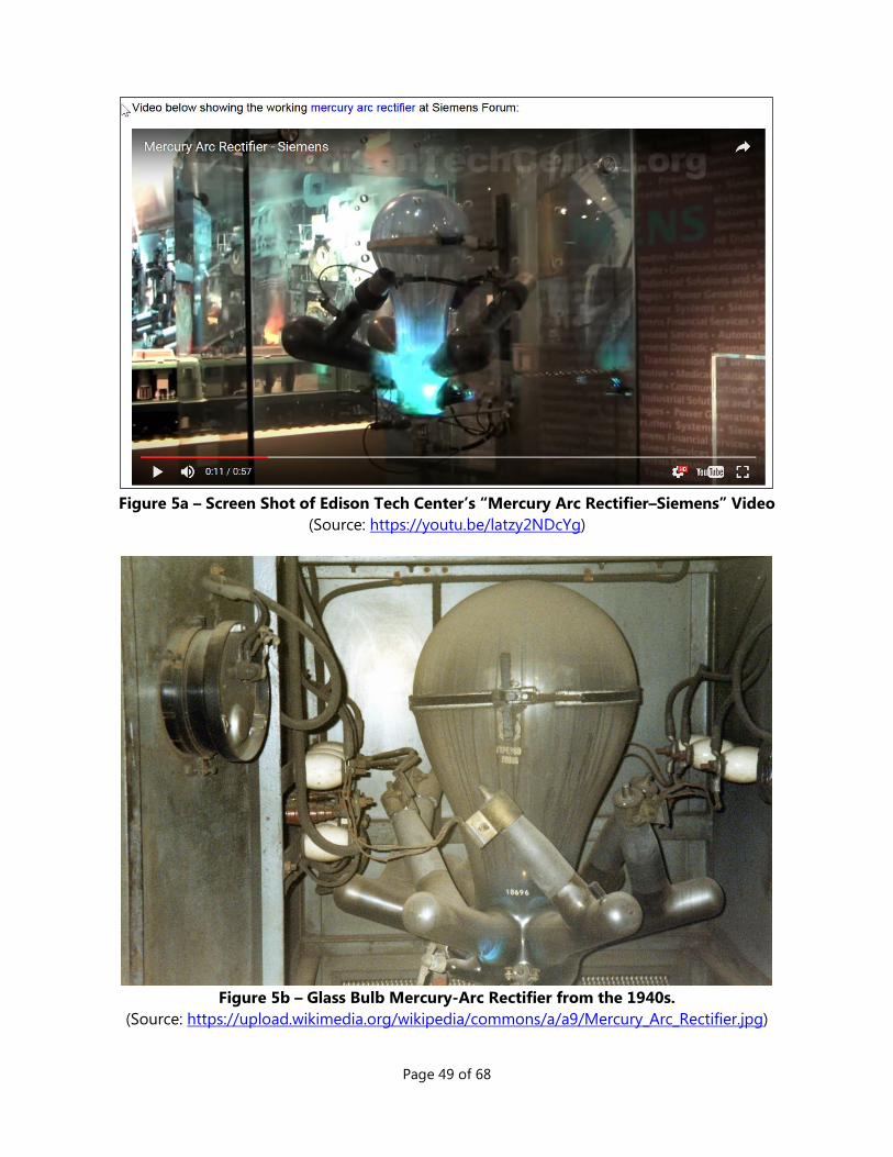
Page 49 of 68
Figure 5a – Screen Shot of Edison Tech Center’s “Mercury Arc Rectifier–Siemens” Video
(Source: https://youtu.be/latzy2NDcYg)
Figure 5b – Glass Bulb Mercury-Arc Rectifier from the 1940s.
(Source: https://upload.wikimedia.org/wikipedia/commons/a/a9/Mercury_Arc_Rectifier.jpg)
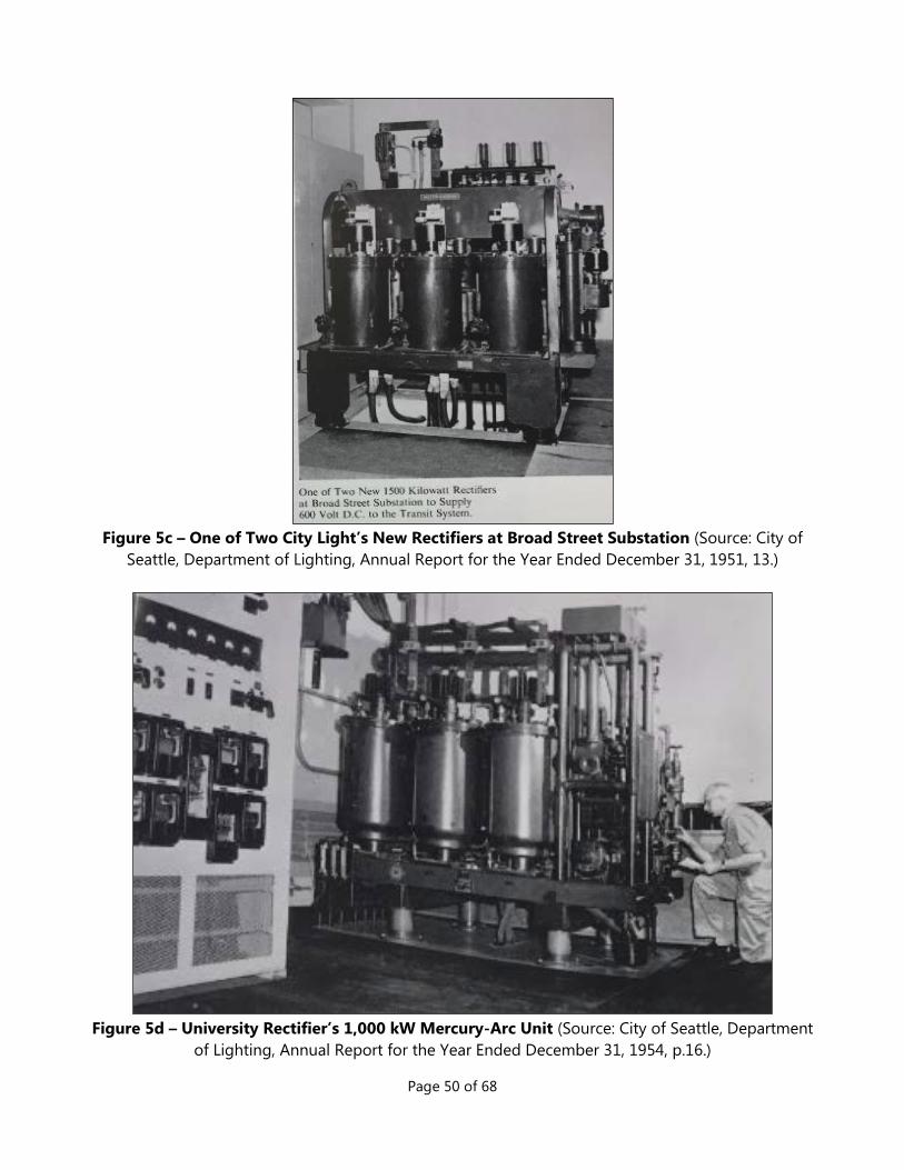
Page 50 of 68
Figure 5c – One of Two City Light’s New Rectifiers at Broad Street Substation (Source: City of
Seattle, Department of Lighting, Annual Report for the Year Ended December 31, 1951, 13.)
Figure 5d – University Rectifier’s 1,000 kW Mercury-Arc Unit (Source: City of Seattle, Department
of Lighting, Annual Report for the Year Ended December 31, 1954, p.16.)

Page 51 of 68
Figure 6 – Plat Map of the Westholme Addition (1918) Avalon located in Block 12.

Page 52 of 68
Figure 7 – Westholme Advertisement (Source: Seattle Times. April 5, 1918, 15.)

Page 53 of 68
Figure 8 – Section Survey of T24N R3E Willamette Meridian
Red box highlights Section 13.119
119 (Bureau of Land Management, 1862)

Page 54 of 68
Figure 9 – Avalon on the 1929 Seattle Sanborn Map.
(Source: Sanborn Fire Insurance Map, Seattle, 1929.)
Figure 10 –1936 Aerial View of Future Avalon Substation Site
Red outline indicates location. (Source: King County GIS Map Center, 1936.)
Lot 14 13 12

Page 55 of 68
Figure 11 – Proposed Economy Builders Inc. Development. 120
120 (Seattle Municipal Archives, 1943)

Page 56 of 68
Figure 12 – Avalon Original Drawing – Plot/Site Plan121
121 (Seattle City Light, 1949). Notations in red added to identify dimensions and location of lots.

Page 57 of 68
Figure 13 – Avalon Original Drawing - Elevations122
Clockwise from upper left are the elevations for north, south, west and east.
122 (Seattle City Light, 1953)

Page 58 of 68
Figure 14 – Avalon Original Drawing - Floor Plan123
123 (Seattle City Light, Year Unknown). Notations in red added to identify interior features.

Page 59 of 68
Figure 15 – Detail View of the Avalon Switch Rack124
124 (Seattle City Light, 1950)

Page 60 of 68
Figure 16 – Aerial View SW Spokane St. Interchange, April 18, 1962.
(Source: SMA #71143)
Avalon Substation

Page 61 of 68
VI. LIST OF FIGURES Figure 1 – Location Map for Avalon Substation within the City of Seattle. ................................................... 46
Figure 2 – Parcel Map (dated 2015) .............................................................................................................................. 47
Figure 3 – Map of Avalon Substation within West Seattle ................................................................................... 47
Figure 4 – Avalon on Kroll map (estimated between 1955 and 1970) ............................................................. 48
Figure 5a – Screen Shot of Edison Tech Center’s “Mercury Arc Rectifier–Siemens” Video...................... 49
Figure 5b – Glass Bulb Mercury-Arc Rectifier from the 1940s. ........................................................................... 49
Figure 5c – One of Two City Light’s New Rectifiers at Broad Street Substation .......................................... 50
Figure 5d – University Rectifier’s 1,000 kW Mercury-Arc Unit ............................................................................ 50
Figure 6 – Plat Map of the Westholme Addition (1918) ....................................................................................... 51
Figure 7 –Westholme Advertisement ........................................................................................................................... 52
Figure 8 – Section Survey of T24N R3E Willamette Meridian ............................................................................. 53
Figure 9 – Avalon on the 1929 Seattle Sanborn Map. ........................................................................................... 54
Figure 10 –1936 Aerial View of Future Avalon Substation Site .......................................................................... 54
Figure 11 – Proposed Economy Builders Inc. Development ................................................................................ 55
Figure 12 – Avalon Original Drawing – Plot/Site Plan ............................................................................................ 56
Figure 13 – Avalon Original Drawing - Elevations ................................................................................................... 57
Figure 14 – Avalon Original Drawing - Floor Plan ................................................................................................... 58
Figure 15 – Detail View of the Avalon Switch Rack ................................................................................................. 59
Figure 16 – Aerial View SW Spokane St. Interchange, April 18, 1962. ............................................................. 60

Page 62 of 68
VII. BIBLIOGRAPHY
Bureau of Land Management. (1862, November 7). General Land Office Records: Subdivision of Sections-Document #322318, 024.0N - 003.0E, King County, WA. Retrieved January 20, 2016, from http://www.glorecords.blm.gov/details/survey/default.aspx?dm_id=322319&sid=xuzmyehs.1ld#surveyDetailsTabIndex=0.
Bureau of Land Management. (1867, January 1). General Land Office Records: Land Patent Details-Document #101382, Accession #MW-0466-497. Retrieved March 15, 2016, from https://www.glorecords.blm.gov/details/patent/default.aspx?accession=0466-497&docClass=MW&sid=xyuzgqdq.qjr.
City of Lynnwood. (2014). Tour of Historic Sites - Lynnwood, Washington. Retrieved January 22, 2016, from Historic Sites - City of Lynnwood.
City of Seattle. (1948). Comptroller File #199707. Seattle: Seattle Municipal Archives.
City Planning Commission. (1943, March 12). Correspondence to Honorable Public Safety Comittee of the City Council. Seattle.
Corman, E. T. (1949). Time, Tide and Timber: A Century of Pope & Talbot. Stanford: Stanford University Press.
DeMeyer, N. (1961, August 24). Plot Plan. Seattle: Unknown.
Department of Archaeology and Historic Preservation. (2011, July 2). Historic Property Inventory Report - Norman DeMeyer Real Estate Office (Inv #SCL021). Retrieved January 22, 2016, from Washington Information System for Architectural and Archaeological Records Data.
Dilbeck, B. (2009, May). From Chopping Trees to Shopping Sprees: The Environmental History of Lynnwood. Retrieved October 15, 2015, from www.rootsweb.ancestry.com/~wasigs/SOUNDER0909DILBECK.
Economy Builders Inc. (1943, February 27). Correspondence to Council of the City of Seattle. Seattle.
Edison Tech Center. (2017, January 31). Mercury Arc Rectifiers. Retrieved January 31, 2017, from Edison Tech Center: http://www.edisontechcenter.org/MercArcRectifiers.html
Gangnes, A. C. (1961, October 16). Real Estate Office for Norman DeMeyer. Seattle: Arnold C. Gangnes, Architect.
Google. (2017, January 30). https://www.google.com/search?q=rectifier&ie=utf-8&oe=utf-8. Retrieved January 30, 2017, from Google: https://www.google.com/search?q=rectifier&ie=utf-8&oe=utf-8
Hoffman, E. R. (1952, August 13). Correspondence - Superintendent of Lighting to Honorable Board of Public Works. Seattle: Seattle City Light.

Page 63 of 68
Johnson, L. (2010). National Register Listing - Skagit River and Newhalem Creek Hydroelectric Projects , Whatcom County,W ashington. Seattle: Seattle.
King County Archives. (1929, January 11). Puget Mill Company to Micklethwaite. Deed and Mortgage Index. Seattle: King County Archives.
King County Archives. (1931, February 9). A. Blackstad to Franklin Financial Co. Deed and Mortgage Index. Seattle: King County Archives.
King County Archives. (1939, March 16). King County to Economy Builders Inc. - Treasurer's Deed #2h630 (Lot 13, Block 12, Westholme). Auditor's Receiving Books. Seattle: King County Archives.
King County Archives. (1939, April 6). King County to Economy Builders Inc. - Treasurer's Deed #2h631 (Lot 14, Block 12, Westholme). Auditor's Receiving Books. Seattle: King County Archives.
King County Archives. (1939, June 22). King County to Economy Builders Inc. - Treasurer's Deed #2h632 (Lot 12, Block 12, Westholme). Auditor's Receiving Books. Seattle: King County Archives.
King County Archives. (1948, May 27). Economy Builders Inc. to City of Seattle. Deed and Mortgage Index (1/1948 to 12/1949). Seattle: King County Archives.
King County Superior Court. (1949, March 14). King County, Economy Builders Inc. v. City of Seattle (1949). Judgement and Decree of Condemnation No. 396274. Seattle: King County Superior Court.
Kramer, G. (2010). Corridors of Power: The Bonneville Power Administration Transmission Network Historic Context Statement. Ashland, OR: BPA.
Kramer, G. (2015). Bonneville Power Administration Pacific Northwest Transmission System Multiple Property Documentation Form. Ashland: BPA.
Oldham, K. (2006, June 18). Metro: Municipality of Metropolitan Seattle. Retrieved January 31, 2017, from Historylink.org: http://www.historylink.org/File/7813
Oldham, K. (2006, June 18). Metro: Municipality of Metropolitan Seattle (HistoryLink.org Essay 7813 ). Retrieved February 01, 2016, from HistoyLink.org.
Peikert, G. R. (1958, June 3). Real Estate Office for Norman DeMeyer. Real Estate Office for Norman DeMeyer. Seattle: George R. Peikert, Architect.
Pennsylvania Historical and Museum Commission. (2017, February 1). International Style 1930-1950 History. Retrieved from Pennsylvania Historical and Museum Commission: http://www.phmc.state.pa.us/portal/communities/architecture/styles/international.html
Reinartz, P. K. (2017, February 15). The Great Depression in King County. Retrieved from History of King County Government 1853 – 2002: http://your.kingcounty.gov/kc150/historical%20overview.pdf
Sanborn Map Company. (1930). Insurance Maps of Seattle, Washington, Volume Eleven, Key Map No. 1. Retrieved May 8, 2015, from Seattle Public Library.

Page 64 of 68
Sanborn Map Company. (1951, March). Insurance Maps of Seattle, Washington, Volume 11, Sheet #1119. Retrieved May 8, 2015, from Seattle Public Library.
Seattle City Light. (1937). City of Seattle Department of Lighting - Annual Report for the Year Ended December 31, 1936. Seattle: Seattle City Light.
Seattle City Light. (1940). City of Seattle Department of Lighting - Annual Report for the Year Ended December 31, 1939. Seattle: Seattle City Light.
Seattle City Light. (1940). Specification No. 565-The Construction of the University and the Roxbury Rectifier Buildings and Concrete Equipment Foundations. Seattle: The City of Seattle Department of Public Works.
Seattle City Light. (1941). City of Seattle Department of Lighting - Annual Report for the Year Ending December 31, 1940. Seattle: Seattle City Light.
Seattle City Light. (1942). City of Seattle Deaprtment of Lighting - Annual Report for the Year Ending December 31, 1941. Seattle: Seattle City Light.
Seattle City Light. (1943). City of Seattle Department of Lighting - Annual Report for the Year Ended December 31, 1942. Seattle: Seattle City Light.
Seattle City Light. (1943). Specification No. 648-The Construction of Reinforced Concrete Substation Building and Equipment for Magnolia Substation at 32nd Avenue West and West Grover Street. Seattle: THe City of Seattle, Department of Public Works.
Seattle City Light. (1944). City of Seattle Department of Lighting - Annual Report for the Year Ended December 31, 1943. Seattle: Seattle City Light.
Seattle City Light. (1945). City of Seattle Department of Lighting - Annual Report for the Year Ended December 31, 1944. Seattle: Seattle City Light.
Seattle City Light. (1946). City of Seattle Department of Lighting - Annual Report for the Year Ended December 31, 1945. Seattle: Seattle City Light.
Seattle City Light. (1947). City of Seattle Department of Lighting - Annual Report for the Year Ended December 31, 1946. Seattle: Seattle City Light.
Seattle City Light. (1947). Specification No. 819-The Construction of Substation Building, Duct Runs, Equipment Foundations, Tower Foundations, Manholes...and Incidental Work for First Hill Substation. Seattle: The City of Seattle Department of Public Works.
Seattle City Light. (1948, August 12). New West Seattle Substation - Condemnation Plat. D-14254. Seattle: Seattle City Light.
Seattle City Light. (1949, August 4). Avalon Substation - Architectural Rectifier Building Plot Plan. D-14415. Seattle: Seattle City Light.

Page 65 of 68
Seattle City Light. (1949). Specification No. 939-Broad Street Substation Department of Lighting: The Construction of Control Building, Crane Tower, Yard Walls, Equipment Foundations, Duct Runs and Incidental Work. Seattle: The City of Seattle Department of Public Works.
Seattle City Light. (1950, January 4). Avalon Substation - Switchrack for Rectifier Station and Unit Substation. D-14459. Seattle: Seattle City Light.
Seattle City Light. (1951). City of Seattle Department of Lighting - Annual Report for the Year Ending December 31, 1950. Seattle: Seattle City Light.
Seattle City Light. (1951). Pool Cathode Mercury Arc Rectifier Units and D-C Feeder Switchgear Units (Avalon, Ballard and Fremont). Seattle: The City of Seattle Department of Lighting.
Seattle City Light. (1951). Specification No. 1080-Concrete Rectifier Buildings and Pads, Errection of Steel Towers, Duct Runs and Miscellaneous Construction at City Light Department's University Rectifier Station and South Rectifier Station. Seattle: The City of Seattle Department of Public Works.
Seattle City Light. (1951). Specification No. 1196-Concrete Rectifier Building, Duct Runs, and Miscellaneous Construction at City Light Department's North Rectifier Substation. Seattle: The City of Seattle Department of Public Works.
Seattle City Light. (1952). City of Seattle Department of Lighting - Annual Report for the Year Ending December 31, 1951. Seattle: Seattle City Light.
Seattle City Light. (1953, March 10). Avalon Rectifier Station - Architectural Rectifier Building Wall Elevations. D-18031. Seattle: Seattle City Light.
Seattle City Light. (1953). Specification No. 1253-The Construction of Concrete Rectifier Buildings, Pads, Ducts, Fences, Walls, Etc. at Olympic Substation, Gatewood Substation, Avalon Substation, Fremont Substation. Seattle: The City of Seattle Department of Public Works.
Seattle City Light. (1953). Specification No. 1304-Construction of Concrete Rectifier Building, Pad, Ducts, Fences, Etc. at Leary Substation. Seattle: The City of Seattle, Department of Public Works.
Seattle City Light. (1954). City of Seattle Department of Lighting - Annual Report for the Year Ended December 31, 1953. Seattle: Seattle City Light.
Seattle City Light. (1954). Specification No. 1320-The Installation of Mercury Arc Rectifiers...and Associated Equipment at Avalon, Fremont, Gatewood, Olympic and Leary Substations. Seattle: The City of Seattle Department of Public Works.
Seattle City Light. (1955). City of Seattle Department of Lighting - Annual Report for the Year Ended December 31, 1954. Seattle: Seattle City Light.
Seattle City Light. (1956). City of Seattle Department of Lighting - Annual Report for the Year Ending December 31, 1955. Seattle: Seattle City Light.
Seattle City Light. (1957). Information on Seattle City Light Installations. Seattle: Seattle City Light.

Page 66 of 68
Seattle City Light. (1962). Power Systems Engineering Information. Seattle: Seattle City Light.
Seattle City Light. (1964). Power Systems Engineering Information. Seattle: Seattle City Light.
Seattle City Light. (1965). Power Systems Engineering Information. Seattle: Seattle City Light.
Seattle City Light. (1966). Power Systems Engineering Information. Seattle: Seattle City Light.
Seattle City Light. (1978). Power Systems Engineering Information. Seattle: Seattle City Light.
Seattle City Light. (1982). Power Systems Engineering Information. Seattle: Seattle City Light.
Seattle City Light. (1990). Power Systems Engineering Information. Seattle: Seattle City Light.
Seattle City Light. (1998). Power Systems Engineering Information. Seattle: Seattle City Light.
Seattle City Light. (2004). Power Systems Engineering Information. Seattle: Seattle City Light.
Seattle City Light. (2011). Power Systems Engineering Information. Seattle: Seattle City Light.
Seattle City Light. (Year Unknown, March 9). Avalon Rectifier Station - Architectural Rectifier Building Floor and Plumbing Plan and Misc. Details. D-18030. Seattle: Seattle City Light.
Seattle Department of Engineering. (1960, November 17). Condemnation for West Spokane Street and Fauntleroy Avenue Overpass. 810-99. Seattle: Seattle Department of Engineering.
Seattle Department of Neighborhoods. (2000, November 13). Seattle Historical Sites - Summary for 4400 35th Ave (Avalon Substation). Retrieved January 22, 2016, from Seattle Department of Neighborhoods: http://web6.seattle.gov/DPD/HistoricalSite/QueryResult.aspx?ID=718003206
Seattle Department of Neighborhoods. (2000, November 13). Seattle Historical Sites - Summary for 7710 35th Avenue (Gatewood Substation). Retrieved from Seattle Historical Sites Database: http://web6.seattle.gov/DPD/HistoricalSite/QueryResult.aspx?ID=-1256805392
Seattle Department of Neighborhoods. (2000, October 27). Seattle Historical Sites - Summary for 9370 52nd Ave (Roxbury Substation). Retrieved from Seattle Department of Neighborhoods: http://web6.seattle.gov/DPD/HistoricalSite/QueryResult.aspx?ID=-458023639
Seattle Department of Planning and Development. (1937-1979). Westholme Property Abstract - Block 12, Lots 12, 13, and 14. Westholme Property Abstract (Microfiche #03354). Seattle: Seattle DPD.
Seattle Municipal Archives. (1943, March 22). Comptroller File #176368 – Petition of Economy Builders Inc. for Rezoning of Lots 12, 13 and 14, Block 12 Westholme Addition. Retrieved December 30, 2015, from Seattle Municipal Archives.
Seattle Municipal Archives. (1948, April 21). Ordinance #76947. Seattle: Seattle Municipal Archives.

Page 67 of 68
Seattle Municipal Archives. (2017, January 30). Seattle Municipal Archives - City Officials. Retrieved January 30, 2017, from Seattle Municipal Archives: https://www.seattle.gov/cityarchives/seattle-facts/city-officials
Seattle Municipal Archives. (n.d.). Multiple Historic Photos. Seattle.
Seattle Times. (1948, March 25). Rain Causes New Slide on Admiral Way, Alki Avenue. Seattle Times, p. 4.
Tate, C. (2001, July 8). Seattle Neighborhoods: West Seattle — Thumbnail History. Retrieved December 8, 2015, from HistoryLink: http://www.historylink.org/File/3428
The Seattle Times. (1958, April 18). New City Light Transformer Stations to Be Attractive. The Seattle Times, p. 23.
The Seattle Times. (1968, September 8). 'Ugly' Utility Stattions Fading. The Seattle Times, p. Unknown.
U.S. National Archives and Records Administration. (1920). United States Census, 1920, Database with Images, A J Felker, Seattle, King, Washington, United States; citing sheet 28A, NARA microfilm publication T625 (Washington D.C.: National Archives and Records Administration, n.d.); FHL microfilm 1,821,931. Retrieved March 14, 2016, from FamilySearch (https://familysearch.org/ark:/61903/1:1:MHFN-KBK ).
U.S. National Archives and Records Administration. (1930). United States Census, 1930, database with images, Thomas C. Micklewaite, Seattle, King, Washington. Retrieved March 23, 2016, from FamilySearch (https://familysearch.org/ark:/61903/1:1:XC3X-41N : accessed 23 March 2016.
Washington, County Land Records, 1850-1954, King, Deed and Mortgage Index-Indirect 1869-1903 Hi-Hy. (1872, October 24). Retrieved March 15, 2016, from https://familysearch.org/ark:/61903/3:1:3QS7-994D-V9MJ-R?mode=g&wc=M6MD-V2S%3A136740701%2C139256801%3Fcc%3D1762885&cc=1762885.
White, C. L.; and Puget Mill Co. (1918, March 25). Westholme An Addition to the City of Seattle. Seattle.
Wickwire, C. (2001, May 20). Survey Report: Comprehensive Inventory of City-Owned Historic Resources- Seattle, Washington. Retrieved July 15, 2015, from Department of Neighborhoods - Historic Preservation: https://www.seattle.gov/Documents/Departments/Neighborhoods/HistoricPreservation/HistoricResourcesSurvey/context-city-owned-buildings.pdf.
Wikipedia. (2015, December 10). Rectifier. Retrieved December 10, 2015, from Wikipedia: https://en.wikipedia.org/wiki/Rectifier
Wikipedia. (2017, March 24). Mercury-Arc Rectifier. Retrieved from Wikipedia: https://en.wikipedia.org/wiki/Mercury-arc_valve
Wikipedia. (2017, January 31). Peter Cooper Hewitt. Retrieved January 31, 2017, from Wikipedia: https://en.wikipedia.org/wiki/Peter_Cooper_Hewitt

Page 68 of 68
Wilma, D. (2003, July 21). HistoryLink.org - Captain William Talbot Establishes A Steam Sawmill at Port Gamble in July 1853. Retrieved January 22, 2016, from http://www.historylink.org/index.cfm?DisplayPage=output.cfm&file_id=5486.
Wilma, D. (2003, August 7). HistoryLink.org - Port Gamble: Thumbnail History. Retrieved 22 January, 2016, from http://www.historylink.org/index.cfm?DisplayPage=output.cfm&file_id=5505.