the challenge of hydrographic surveying and charting the ... · the challenge of hydrographic...
TRANSCRIPT
Page 1 of 12
TS 91 – Nautical Charting – Marine Cartography
Roderick Nairn, Australia
The Challenge of Hydrographic Surveying and Charting the Antarctic
FIG Congress 2010
Facing the Challenges – Building the Capacity
Sydney, Australia, 11-16 April 2010
The Challenge of Hydrographic Surveying and Charting the
Antarctic
Roderick NAIRN, Australia
Key words: Antarctic, hydrographic surveying, charting, international, treaty
SUMMARY
The Antarctic represents unique challenges for surveying and charting due to its
remoteness, severe climatic conditions and political circumstance. Nevertheless the
need for accurate and reliable nautical charts has never been greater especially with
the increasing number of vessels of all sizes navigating the area for scientific research,
in support of national Antarctic programs and, ever increasingly, for “eco-tourism”.
This paper discusses the need for hydrographic surveys and charting in Antarctica, it
outlines the challenges faced in coordinating efforts to undertake surveys and produce
charts in Antarctic waters (largely undertaken by the International Hydrographic
Organization’s Hydrographic Sub-Committee on Antarctica) and finally it provides an
insight into the practical challenges of conducting hydrographic surveys in the harsh
conditions of the Antarctic.
Page 2 of 12
TS 91 – Nautical Charting – Marine Cartography
Roderick Nairn, Australia
The Challenge of Hydrographic Surveying and Charting the Antarctic
FIG Congress 2010
Facing the Challenges – Building the Capacity
Sydney, Australia, 11-16 April 2010
The Challenge of Hydrographic Surveying and Charting the
Antarctic
Roderick NAIRN, Australia
1.0 INTRODUCTION
1.1 Accurate, comprehensive and reliable nautical charts are essential for safe and
efficient movement of marine traffic. Nautical charts also provide the base level,
three dimensional situational awareness framework that supports scientific research
and conservation efforts. Hydrography provides the underpinning information to
produce these nautical charts, thus is the fundamental enabler of safe navigation and
marine scientific research. The detailed bathymetry, bottom texture information and
water column data such as sea temperature and salinity, collected during hydrographic
surveys provide critical ground truth to support wide area analysis using remote
satellite sensors and are essential to the modelling and understanding of oceanic
currents and sea temperature trends.
1.2 Hydrographic data assists in the prevention of maritime accidents in two
principal ways. Firstly, identification and publishing of hazards to navigation allows
ships to safely avoid them. Secondly, by “providing data for electronic navigation (in
which ships’ positions from satellite are displayed continuously with chart
information) they help to reduce human error in navigation which, at present, is the
most common cause of shipwrecks.”1
1.3 The Antarctic is a unique region, characterised by its remoteness, its hostile
extreme climatic conditions and its void status with respect to internationally
recognised national sovereignty. These factors combine to create special challenges
in the conduct of hydrographic surveys and the provision of comprehensive
coordinated coverage of nautical charts.
2.0 STATUS OF SURVEYING AND CHARTING IN THE ANTARCTIC
2.1 According to the Council of Managers of National Antarctic Programs
(COMNAP), “less than 1% of the sea area within the 200m contour has been
adequately surveyed to meet the needs of contemporary shipping entering Antarctic
waters. The channels and approaches to bases around the Antarctic Peninsula have
seen the most intensive effort, yet even here, some 60% of the area within the 200m
contour has never been systematically surveyed, while the remainder requires re-
survey. Elsewhere, barely 1% of the area within the 200m contour has been
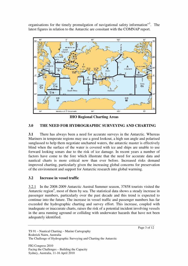
systematically surveyed.”2 The International Hydrographic Organization (IHO)
continually monitors information on the status of surveying and charting world wide
in its publication C-55. The purpose of which is “to present a clear picture of the
worldwide coverage of surveys and nautical charts and of the extent of effective
Page 3 of 12
TS 91 – Nautical Charting – Marine Cartography
Roderick Nairn, Australia
The Challenge of Hydrographic Surveying and Charting the Antarctic
FIG Congress 2010
Facing the Challenges – Building the Capacity
Sydney, Australia, 11-16 April 2010
organisations for the timely promulgation of navigational safety information”3. The
latest figures in relation to the Antarctic are consitant with the COMNAP report.
IHO Regional Charting Areas
3.0 THE NEED FOR HYDROGRAPHIC SURVEYING AND CHARTING
3.1 There has always been a need for accurate surveys in the Antarctic. Whereas
Mariners in temperate regions may use a good lookout, a high sun angle and polarised
sunglassed to help them negotiate uncharted waters, the antarctic master is effectively
blind when the surface of the water is covered with ice and ships are unable to use
forward looking sonars due to the risk of ice damage. In recent years a number of
factors have come to the fore which illustrate that the need for accurate data and
nautical charts is more critical now than ever before. Increased risks demand
improved charting, particularly given the increasing global concerns for preservation
of the environment and support for Antarctic research into global warming.
3.2 Increase in vessel traffic
3.2.1 In the 2008-2009 Antarctic Austral Summer season, 37858 tourists visited the
Antarctic region4, most of them by sea. The statistical data shows a steady increase in
passenger numbers, particularly over the past decade and this trend is expected to
continue into the future. The increase in vessel traffic and passenger numbers has far
exceeded the hydrographic charting and survey effort. This increase, coupled with
inadequate or inaccurate charts, raises the risk of a potential incident involving vessels
in the area running aground or colliding with underwater hazards that have not been
adequately identified.

Page 4 of 12
TS 91 – Nautical Charting – Marine Cartography
Roderick Nairn, Australia
The Challenge of Hydrographic Surveying and Charting the Antarctic
FIG Congress 2010
Facing the Challenges – Building the Capacity
Sydney, Australia, 11-16 April 2010
3.3 Increase in vessel size
3.3.1 In the past decade the average size of tourist vessels entering the Antarctic
region has increased, with some vessels carrying up to 1,000 passengers.5 With the
increase in size of vessels there are higher risks relating to inadequate charting.
Deeper drafts mean that the risk of vessels running aground or colliding with
obstacles is greater. Where surveys are incomplete and areas poorly charted ships
traditionally plan to pass over the same ground as previous voyages in order to
minimise their risk. However with substantial increases in ship’s draught even this
principle offers little assurance of safety, as previous voyages were likely to be in
shallower ships. More importantly, an increase in the size and passenger capacity will
inevitably lead to a great human and environmental tragedy in the event of a collision
or incident.
3.4 Increased Pressure on Tour Operators for New Sites
3.4.1 With the popularity of Antarctica increasing as a tourist destination, there has
come increasing competition between tour operators. They seek to arrive at landing
areas first and are thus encouraged to transit at higher speeds which may be
considered imprudent, especially where ships are not ice strengthened and floating ice
is present. There is also increased pressure on tour operators to take passengers to
hitherto unvisited and increasingly more remote areas in order to avoid other tourist
groups and to enhance the wildlife experience of the guests. This poses the greatest
demand for new surveys and presents a particular risk as vessels will otherwise be
entering waters which are potentially more dangerous because of little or no survey
data being available.
Page 5 of 12
TS 91 – Nautical Charting – Marine Cartography
Roderick Nairn, Australia
The Challenge of Hydrographic Surveying and Charting the Antarctic
FIG Congress 2010
Facing the Challenges – Building the Capacity
Sydney, Australia, 11-16 April 2010
3.5 Increased Global Awareness and Support for Protection of the
Environment
3.5.1 In 1991 the Consultative Parties to the Antarctic Treaty adopted the Protocol
on Environmental Protection to the Antarctic Treaty. This Protocol sets out
environmental principles, procedures and obligations for the comprehensive
protection of the Antarctic environment, and its dependent and associated ecosystems.
However the important matter of navigational safety received little consideration in
this Protocol.
3.5.2 The International Association of Antarctica Tour Operators (IAATO) was also
created in 1991 to advocate, promote and practice safe and environmentally
responsible private sector travel to the Antarctic6. Amongst their members they have
adopted strict codes for management of tourism activities to aim for zero impact on
the habitat and environment, this includes limiting their activities to adequately
charted waters.
3.5.3 Globally the general public awareness and concern about protection of the
environment has escalated over the past decade, particularly with the information
revolution made possible by satellite communications and the internet. It means that
virtually any incident, anywhere in the world can be available in people’s living
rooms in colour video within minutes.
4.0 ORGANISATIONAL CHALLENGES OF SURVEYING AND
CHARTING THE ANTARCTIC
4.1 The Antarctic is generally considered to include the area south of 60 degrees
South but actually includes some areas further north as it is defined as the whole area
south of the Antarctic Convergence and includes the continent, off lying and oceanic
islands, ice shelves, sea ice and the ocean.
4.2 The Antarctic region is subject to numerous international conventions and
agreements. Pre-eminent among them is the Antarctic Treaty which entered into
force in 1961. Australia was one of the 12 original signatories of the Treaty, the total
number of parties currently stands at 47.7 A number of States have claimed territory
within the Antarctic region, however other States have consistently refused to
recognise any of these claims. Australia’s Antarctic Territory claim was formalised in
1933, pre-existing the Antarctic Treaty. It is recognised by France, New Zealand,
Norway and the United Kingdom. Article IV of the Antarctic Treaty, whilst in force,
preserves the status quo in terms of Antarctic Claims. It states inter alia that:
“Nothing contained in the present Treaty shall be interpreted as: ..... a renunciation or
diminution by any Contracting Party of any basis of claim to territorial sovereignty in
Antarctica which it may have whether as a result of its activities or those of its
nationals in Antarctica” 8 but the article also prevents pursuance of actions to enhance
claims stating that: ”No acts or activities taking place while the present Treaty is in
force shall constitute a basis for asserting, supporting or denying a claim to territorial
Page 6 of 12
TS 91 – Nautical Charting – Marine Cartography
Roderick Nairn, Australia
The Challenge of Hydrographic Surveying and Charting the Antarctic
FIG Congress 2010
Facing the Challenges – Building the Capacity
Sydney, Australia, 11-16 April 2010
sovereignty in Antarctica or create any rights of sovereignty in Antarctica. No new
claim, or enlargement of an existing claim, to territorial sovereignty in Antarctica
shall be asserted while the present Treaty is in force”9.
4.3 Responsibilities for Surveying, Charting and Hydrographic Services
4.3.1 The Safety of Life at Sea (SOLAS) Convention which has been widely
adopted world wide, defines the responsibilities and obligations of coastal states
regarding the provision of hydrographic services. Chapter 5, Regulation 9 provides
clear rules for contracting governments as to what is expected of them regarding the
collection, compilation, publication, dissemination and keeping up to date of nautical
information required for safe navigation to the limits of their territorial seas. In
combination with the requirements of the United Nations Convention on Law of the
Sea (UNCLOS) many of these requirements are extended to the Exclusive Economic
Zones.
4.3.2 The responsibilities for these services in the high seas are however, not
defined in international law. The IHO has implemented a cooperative approach
towards coordinating the charting of international areas. Through a network of
Regional Hydrographic Commissions (RHCs) consisting of States with territory in the
region, consultation is encouraged and each RHC produces a schema of International
Charts and agrees on the responsibility for production.
4.3.3 The Antarctic is a different case again, whilst multiple (in some cases
overlapping) territorial claims exist there are no universally recognised sovereign
States and so no State can be held to have territory in the region. Accordingly, the
responsibilities for Hydrographic Services defined in SOLAS cannot be effectively
applied and even the concept of a Regional Hydrographic Commission does not
neatly fit. To overcome this dilemma the IHO has defined a Hydrographic Sub-
Committee on Antarctica which allows membership to any State who has acceded to
the Antarctic Treaty, signed the statutes of the HCA and contributes to the surveying
and charting of the Antarctic. At the time of writing there are 19 Antarctic Treaty
Parties participating in the HCA10
, there are also a number of affiliated organisations
which have observer status. The statutes of the HCA attempt to overcome the lack of
specific accountabilities of States with respect to surveying and charting in the
Antarctic. The HCA pursues the goal of continually improving the standard of
nautical charting in the region in order to provide the essential information to allow
safe navigation of ships. The HCA’s aims include to: “promote technical co-
operation in the domain of hydrographic surveying, marine cartography and nautical
information in the region…to implement the INT chart scheme for the region…..to
facilitate the exchange of information between Hydrographic Authorities.”11
4.4 Coordination of Surveying and Charting Effort
4.4.1 The HCA has proven to be a reasonably effective organ to coordinate the
international charting scheme for the Antarctic region. Many States have been willing
Page 7 of 12
TS 91 – Nautical Charting – Marine Cartography
Roderick Nairn, Australia
The Challenge of Hydrographic Surveying and Charting the Antarctic
FIG Congress 2010
Facing the Challenges – Building the Capacity
Sydney, Australia, 11-16 April 2010
to take on the responsibility for production of International Charts and there is a
comprehensive large and small scale nautical chart scheme covering the region. To
support this scheme it promotes the open and efficient sharing of hydrographic
surveying data particularly to ensure that the State responsible for the production of
each international nautical chart is provided with any data collected by any other
State. However, in practice this goal is far from achieved and some States have been
unwilling to share their data, thus tending to undermine this otherwise very effective
organisation. An Electronic Navigation Chart schema has also recently been
produced. However the quality of the charting remains generally poor, due to the
sparsity of hydrographic information. The elephant in the room is the requirement for
substantial investment in hydrographic surveying activities to provide the necessary
data.
4.4.2 Whilst States have shown a willingness to contribute to the altruistic goals of
improved safety of navigation, ultimately they will prioritise their actions in their own
national interest. Without the obligations that arise from sovereignty over a particular
area within Antarctic, States have generally been reluctant to invest significant time
and resources into undertaking surveying and charting activities which do not directly
benefit them. Such survey and charting cannot be held to be a national obligation,
regardless of the existence of a territorial claim. Hydrographic surveying is both
expensive and time consuming. Treaty Member States are likely to have higher
priority survey taskings within their recognised areas of maritime jurisdiction, so
survey taskings in Antarctica may not be addressed.
4.4.3 The HCA has been actively engaging with other international groups to
encourage national investment in hydrographic surveying in the Antarctic. The XXVI
meeting of the ATCM (Madrid) adopted Resolution 3 (2003) which included a call
for national authorities to “redouble their efforts to:….coordinate their hydrographic
and charting activities through the IHO’s Hydrographic Commission on
Antarctica,……support and contribute to the ongoing development of the INT chart
scheme.” Five years later, an HCA presentation to ATCM XXXI (Kyiv) supported
the adoption of Resolution 5 (2008) which included the specific recommendations to
“forward any Antarctic hydrographic and bathymetric data collected to the relevant
international producer for charting action; and endeavour to find additional resources
towards improving hydrographic surveying and charting in the Antarctic region.”12
Despite these positive outcomes, progress continues to be slow.
4.4.4 Opportunistic data collection is another source of hydrographic information to
update charting. The IHO is the single point of collection for any passage sounding
data provided by participating national or tourist vessels. The HCA through
cooperation with COMNAP and IAATO has updated the instructions for collecting
and rendering of hydrographic information and promoted its use.
4.4.5 Despite these efforts there is no doubt that a great deal of hydrographic
information for the Antarctic region has not been shared and so has not been used to
update nautical charts. An initiative to seek out and capture all possible bathymetric
Page 8 of 12
TS 91 – Nautical Charting – Marine Cartography
Roderick Nairn, Australia
The Challenge of Hydrographic Surveying and Charting the Antarctic
FIG Congress 2010
Facing the Challenges – Building the Capacity
Sydney, Australia, 11-16 April 2010
information to create an International Bathymetric Chart of the Southern Ocean is
being undertaken with the support of the International Oceanographic Commission
Regional Mapping Program and the Geosciences Expert Group from the Scientific
Committee on Antarctic Research. The project has already identified a number of
datasets that have not been included in international nautical charts.
5.0 PRACTICAL CHALLENGES OF ANTARCTIC HYDROGRAPHIC
SURVEYING
5.1 A Very Limited Survey Window
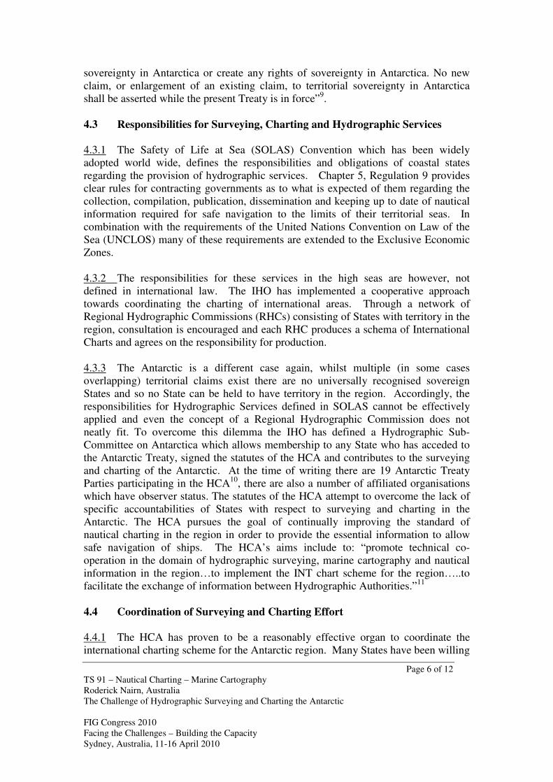
5.1.1 Antarctica is well known as a place of great beauty as well as being one of the
most hostile environments on Earth. Adverse and extreme oceanic and meteorological
conditions make the task of hydrographic surveying particularly challenging.
Collection of survey data is subject to favourable weather and the absence of ice. In
many coastal areas the survey season is limited to one or two months per year when
the area is relatively ice free. Even within these periods grounded icebergs can
restrict access and onshore winds can move broken pack ice back to obstruct the
survey area. This means that there is only a very limited window of opportunity to
collect hydrographic data in the region.
Pack Ice on the Approach to Mawson Station
5.2 Hostile Environment
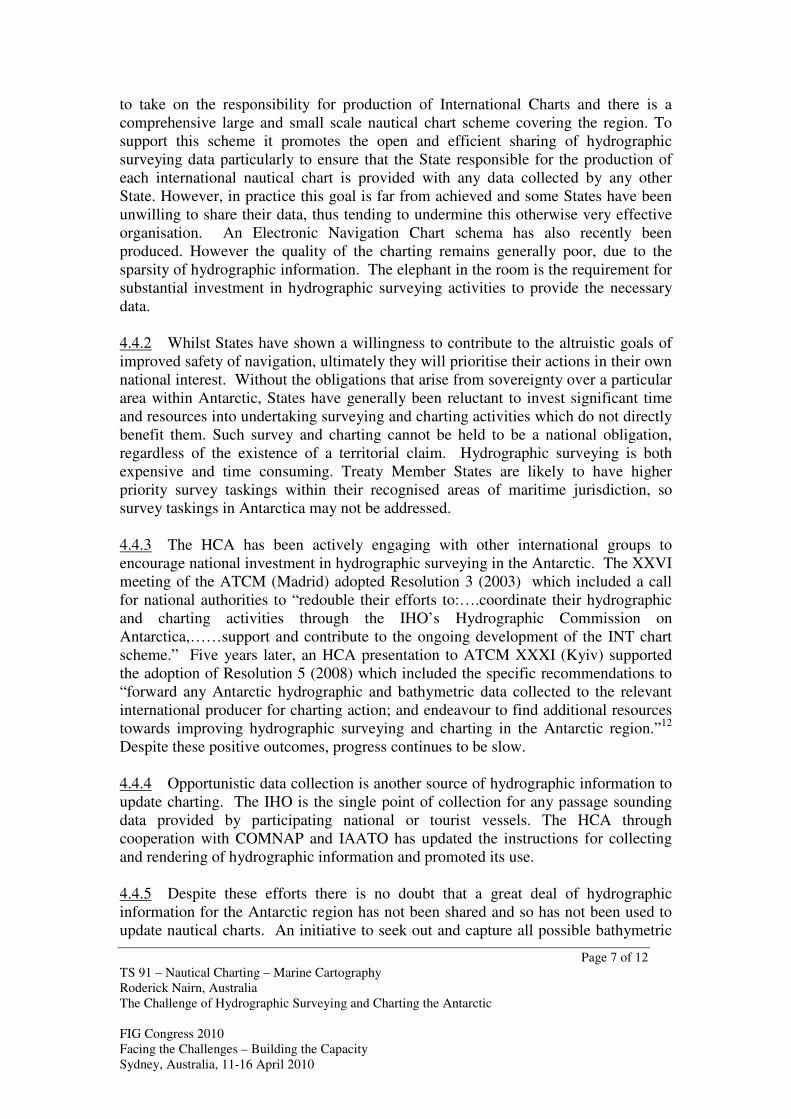
5.2.1 The Antarctic is an area of extremes and conditions can change rapidly, strong
katabatic winds are a regular feature. Small survey boats, which are required for
operations in unsurveyed, dangerous areas are far more susceptible to high winds and
sea conditions than larger ships. Accordingly, their operations are restricted and they
require close support from larger vessels. This is not always possible if the resupply
support ships have other priority tasks – the result is further reduction to the survey
output. Strong winds, freezing temperatures and ice floes present high risks to survey
equipment as well as to personnel. Personnel require special training in safety and
survival and whilst careful planning can help to ensure appropriate spares are
available any catastrophic equipment failure can result in the loss of an entire survey
season.
Page 9 of 12
TS 91 – Nautical Charting – Marine Cartography
Roderick Nairn, Australia
The Challenge of Hydrographic Surveying and Charting the Antarctic
FIG Congress 2010
Facing the Challenges – Building the Capacity
Sydney, Australia, 11-16 April 2010
Survey Boat Caught in High Winds
5.3 Remote Locality
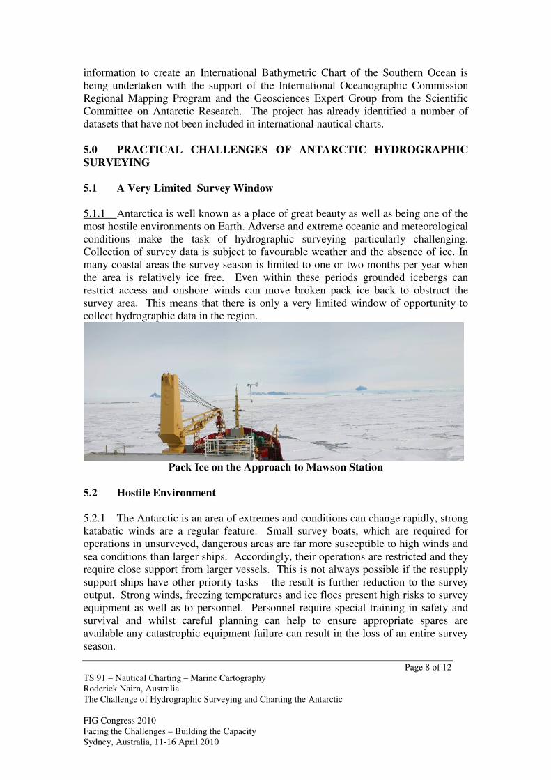
5.3.1 From the Australian perspective the Antarctic is especially remote. The
Australian Hydrographic Service has no ice capable ships and has to rely on
Australian Antarctic Division resupply ships to transport and support their 9 metre
Antarctic survey vessel. Survey deployment programmes are dictated by the busy
summer station re-supply shipping schedules which are promulgated 12 months in
advance. The transit from mainland Australia to survey areas in the vicinity of
Australian Antarctic bases takes in 12-14 days and when no support ship is available
survey operations are restricted to within 15 km of the shore base. The survey team is
sometimes deployed for 3 months awaiting a return passage on the resupply ship but
unfavourable ice conditions may prevent survey operations for long periods. Any
unexpected equipment failures can result in the entire deployment being
unproductive.
Page 10 of 12
TS 91 – Nautical Charting – Marine Cartography
Roderick Nairn, Australia
The Challenge of Hydrographic Surveying and Charting the Antarctic
FIG Congress 2010
Facing the Challenges – Building the Capacity
Sydney, Australia, 11-16 April 2010
Australian Antarctic Voyages 2008-2009 Season
6.0 CONCLUSIONS
6.1 Less than 1% of the sea area within the 200m contour has been adequately
charted to meet the needs of contemporary shipping entering Antarctic waters. It is
clear that there is a well established need for accurate and reliable nautical charts of
the Antarctic region to support safe navigation, scientific research and increasing
levels of adventure tourism. This need is becoming more urgent as the trend to
increasing size and numbers of ships visiting the region continues. Hydrographic data
collection is also important to scientific studies for the good of mankind. “The
Southern Ocean bathymetry is of great importance for the modelling and
understanding of ocean gateways and barriers, the nature of the thermohaline
circulation with Antarctic bottom water formation, and the relevance of the Antarctic
Circumpolar Current for Antarctica’s glaciation. The sea floor topography controls
ocean circulation and ocean mixing - and has strong influence on global climate.”13
6.2 The unique political circumstance of the Antarctic, with no territorial claims
being recognised whilst the Antarctic Treaty remains in force has two main outcomes:
there are no universally recognised coastal states who can regulate the movements of
shipping within the region, and there are no enforceable national obligations for the
provision of nautical information and hydrographic services to ensure safety of
navigation. The net result is that the pursuance of improved survey and charting of
the Antarctic can only be achieved through international cooperative efforts. While
there is strong international “in principle” support for committing additional resources
to hydrographic surveying in the Antarctic, the propensity of States to act in their own
national self interest will prevail and no substantial increase is likely in the near term.
6.3 The IHO HCA has been successful in establishing a framework for
cooperation and information sharing and there is a reasonably comprehensive scheme
of nautical charts covering the Antarctic region, however the majority of the charts are
based on inaccurate or incomplete hydrographic information. The agreed principles
of information sharing have not yet been realised as well as they might, this is an area
that requires further effort.
6.4 In addition to these organisational difficulties, the Antarctic represents unique
challenges for hydrographic surveying from a practical perspective. There is a very
limited annual survey season and even during this period its harsh climate and rapidly
changing weather conditions create high risk to both personnel and equipment and
limit the effectiveness of survey operations.
6.5 The challenge of hydrographic surveying and charting the Antarctic will be
with us for generations to come.
Page 11 of 12
TS 91 – Nautical Charting – Marine Cartography
Roderick Nairn, Australia
The Challenge of Hydrographic Surveying and Charting the Antarctic
FIG Congress 2010
Facing the Challenges – Building the Capacity
Sydney, Australia, 11-16 April 2010
Endnotes: 1 Council of Manager of National Antarctic Programs (COMNAP). Overview of Antarctic Charting
and Hydrography. Retrieved 20/01/2010 https://www.comnap.aq/operations/charting/ 2 COMNAP. ATCM XXX/IP50 International Coordination of Hydrography in Antarctica:
Significance to Safety of Antarctic Ship Operations. May 2007. 3 International Hydrographic Organisation (IHO). Publication C-55, Executive Summary. Retrieved
21/01/2010 http://www.iho.shom.fr/PUBLICATIONS/S-55/S_55.htm 4 International Association of Antarctica Tour Operators (IAATO). IP89 UPDATED REVISION
Overview of Antarctic Tourism: 2008-2009 Antarctic Season and Preliminary Estimates for 2009-2010
Antarctic Season. Retrieved 20/01/2010 from http://www.iaato.org/info.html 5 IAATO. Scope of Antarctic Tourism- A Background Presentation. Downloaded 09/04/2008 from
http://www.iaato.org/tourism_overview.html 6 IAATO. Objectives. Retrieved 21/01/2010 from http://www.iaato.org/objectives.html
7 Antarctic Treaty Secretariat. The Antarctic Treaty. Retrieved 20/01/2010 from
http://www.ats.aq/e/ats_treaty.htm 8 Article IV – 1.b, The Antarctic Treaty 1959, Retrieved 21/01/2010 from
https://www.comnap.aq/treaty 9 Article IV – 2, The Antarctic Treaty 1959, Retrieved 21/01/2010 from https://www.comnap.aq/treaty
10 International Hydrographic Organization (IHO). IHO Hydrographic Commission of Antarctica.
Downloaded 10/04/2008 http://www.iho.shom.fr/REG_HYD_COM/HCA/HCA.htm 11
International Hydrographic Organization (IHO). Statutes of the IHO Hydrographic Commission on
Antarctica, Paragraph 3. Downloaded 21/10/2010 from http://www.iho-
ohi.net/mtg_docs/rhc/HCA/HCA_Misc/HCA_STATUTES.pdf 12
Antarctic Treaty Consultative Meeting XXXI (Kyiv ), Resolution 5 (2008) retrieved from 13
International Bathymetric Chart of the Southern Ocean. The Significance of Southern Ocean
Bathymetry. Retrieved 21/01/2010 from http://www.ibcso.org/why.html
REFERENCES
• Antarctic Treaty Secretariat. The Antarctic Treaty. Retrieved 20/01/2010 from
http://www.ats.aq/e/ats_treaty.htm
• Council of Manager of National Antarctic Programs (COMNAP). Overview of
Antarctic Charting and Hydrography. Retrieved 20/01/2010
https://www.comnap.aq/operations/charting/
• COMNAP. ATCM XXX/IP50 International Coordination of Hydrography in
Antarctica: Significance to Safety of Antarctic Ship Operations. May 2007.
• International Association of Antarctica Tour Operators (IAATO). IP89 UPDATED
REVISION Overview of Antarctic Tourism: 2008-2009 Antarctic Season and
Preliminary Estimates for 2009-2010 Antarctic Season. Retrieved 20/01/2010 from
http://www.iaato.org/info.html
• IAATO. Scope of Antarctic Tourism- A Background Presentation. Retrieved 09/04/2008 from
http://www.iaato.org/tourism_overview.html
• International Hydrographic Organization (IHO). IHO Hydrographic Commission of
Antarctica. Downloaded 10/04/2008
http://www.iho.shom.fr/REG_HYD_COM/HCA/HCA.htm

Page 12 of 12
TS 91 – Nautical Charting – Marine Cartography
Roderick Nairn, Australia
The Challenge of Hydrographic Surveying and Charting the Antarctic
FIG Congress 2010
Facing the Challenges – Building the Capacity
Sydney, Australia, 11-16 April 2010
BIOGRAPHICAL NOTES
Commodore Roderick Nairn [MA (Strategic Studies), B.Surv (Hons), Cert. Prof.
Hydrographic Surveyor Level 1, SSSI] is currently Hydrographer of Australia and
Director General Navy Hydrography and METOC Branch. He joined the Royal
Australian Navy in 1975 and his seagoing career encompasses hydrographic
surveying experience around Australia, New Zealand, the South West Pacific, the
English Channel and the Norwegian Sea. Career highlights include four sea
Commands, the operational introduction of the worlds first Laser Airborne Depth
Sounder, commissioning of HMA Ships Melville and Leeuwin and the successful
introduction of multi-crewing to the Royal Australian Navy.
Commodore Nairn is currently Chairman of the Australasian Hydrographic Surveyors
Certification Panel, the Permanent Committee on Tides and Mean Sea Level and the
Ports Australia Port Surveyors Working Group.
CONTACTS Commodore Roderick Nairn
Royal Australian Navy
Australian Hydrographic Service
Locked Bag 8801
Wollongong, NSW, 2500
AUSTRALIA
Tel. +61 2 4223500
Fax +61 2 4223599
Email:[email protected]
Web site: www.hydro.gov.au