the architectural legacy of mount pleasant street - dmv.dc.gov · streetcar route which became...
TRANSCRIPT

Today’s Mount Pleasant neighborhood in Washington, D.C., developed as a “streetcar suburb” in the early 1900s. The new area was defined geographically in 1901 when 16th Street was extended north from Florida Avenue, creating a natural boundary to the east. The much-anticipated opening of a new streetcar line to Mount Pleasant in 1903 unleashed a building boom. Major developers converged on the neighborhood to respond to the seemingly insatiable demand for housing in convenient proximity to downtown Washington. Along the streetcar route which became Mount Pleasant Street, they built rowhouses, apartment houses and commercial buildings, many with attached dwellings. The vast majority of these buildings are still standing and are protected as contributing structures within the Mount Pleasant Historic District.
Historic Mount Pleasant, a nonprofit organization formed to preserve the history and architectural resources of the neighborhood, is compiling a comprehensive history of the Mount Pleasant commercial corridor. This is a brief overview of our findings to date. The information comes from the National Archives and Records Administration, the Washingtoniana Collection of the D.C. Public Library, the D.C. Recorder of Deeds, and the Historical Society of Washington, D.C. More information about building permits, land titles, and the location of individual businesses over time is available on our website, www.historicmountpleasant.org. We thank Studio Crowley Hall for its assistance in refining and creating drawings for use here. We welcome comments and questions and plan to prepare a complete summary of our research in 2011. The 1903 Baist map to the left shows the then undeveloped state of the area that would become the 3000-3200 blocks of Mount Pleasant Street, the new commercial corridor. Mount Pleasant Street is labeled “16 ½ Street,” as it was known immediately after new 16th Street was laid out. There were only a few buildings between Kenesaw (now Irving) Street and Park Road along the new corridor and much open space. Of those buildings, only one remains – represented by the pink square in the center near the number “6.” © 2010 by Historic Mount Pleasant, Inc.
THE ARCHITECTURAL LEGACY OF MOUNT PLEASANT STREET
2
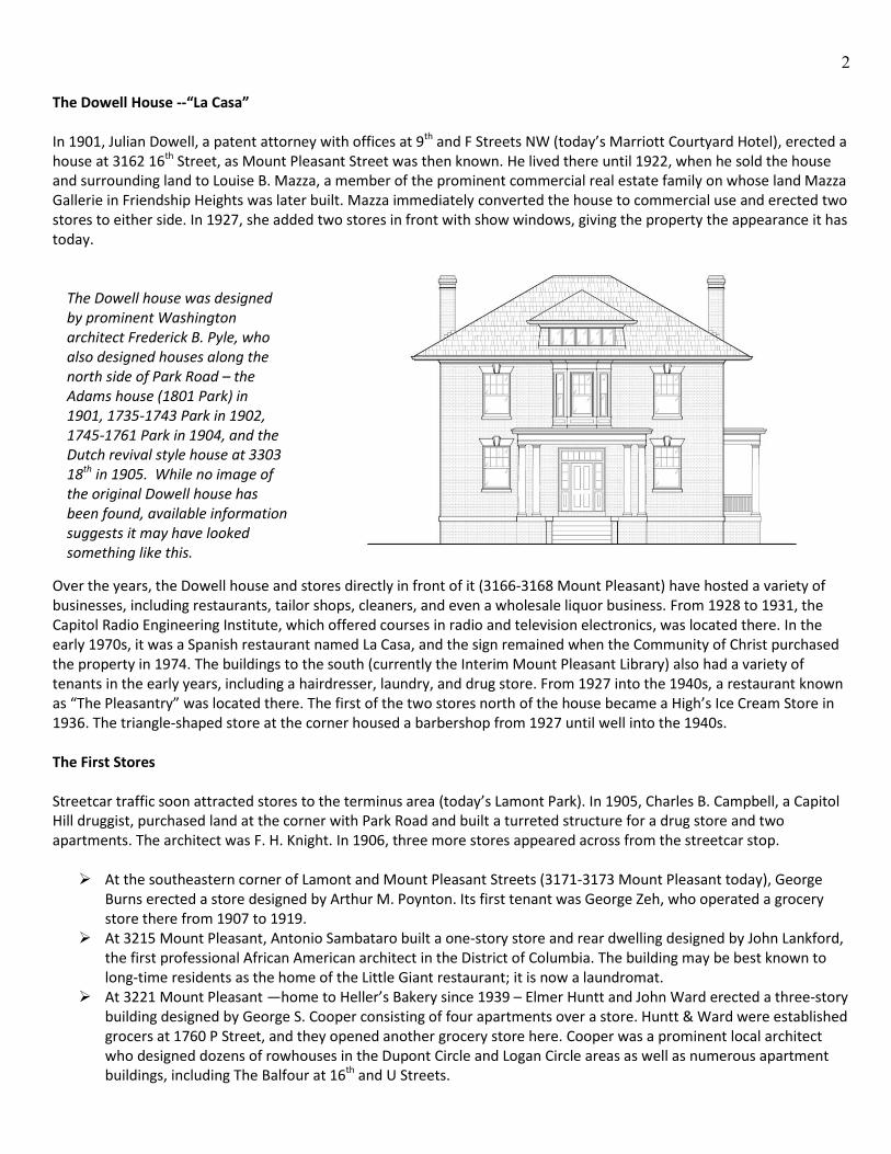
The Dowell House --“La Casa”
In 1901, Julian Dowell, a patent attorney with offices at 9th and F Streets NW (today’s Marriott Courtyard Hotel), erected a house at 3162 16th Street, as Mount Pleasant Street was then known. He lived there until 1922, when he sold the house and surrounding land to Louise B. Mazza, a member of the prominent commercial real estate family on whose land Mazza Gallerie in Friendship Heights was later built. Mazza immediately converted the house to commercial use and erected two stores to either side. In 1927, she added two stores in front with show windows, giving the property the appearance it has today.
The Dowell house was designed by prominent Washington architect Frederick B. Pyle, who also designed houses along the north side of Park Road – the Adams house (1801 Park) in 1901, 1735-1743 Park in 1902, 1745-1761 Park in 1904, and the Dutch revival style house at 3303 18th in 1905. While no image of the original Dowell house has been found, available information suggests it may have looked something like this.
Over the years, the Dowell house and stores directly in front of it (3166-3168 Mount Pleasant) have hosted a variety of businesses, including restaurants, tailor shops, cleaners, and even a wholesale liquor business. From 1928 to 1931, the Capitol Radio Engineering Institute, which offered courses in radio and television electronics, was located there. In the early 1970s, it was a Spanish restaurant named La Casa, and the sign remained when the Community of Christ purchased the property in 1974. The buildings to the south (currently the Interim Mount Pleasant Library) also had a variety of tenants in the early years, including a hairdresser, laundry, and drug store. From 1927 into the 1940s, a restaurant known as “The Pleasantry” was located there. The first of the two stores north of the house became a High’s Ice Cream Store in 1936. The triangle-shaped store at the corner housed a barbershop from 1927 until well into the 1940s. The First Stores Streetcar traffic soon attracted stores to the terminus area (today’s Lamont Park). In 1905, Charles B. Campbell, a Capitol Hill druggist, purchased land at the corner with Park Road and built a turreted structure for a drug store and two apartments. The architect was F. H. Knight. In 1906, three more stores appeared across from the streetcar stop. At the southeastern corner of Lamont and Mount Pleasant Streets (3171-3173 Mount Pleasant today), George
Burns erected a store designed by Arthur M. Poynton. Its first tenant was George Zeh, who operated a grocery store there from 1907 to 1919.
At 3215 Mount Pleasant, Antonio Sambataro built a one-story store and rear dwelling designed by John Lankford, the first professional African American architect in the District of Columbia. The building may be best known to long-time residents as the home of the Little Giant restaurant; it is now a laundromat.
At 3221 Mount Pleasant —home to Heller’s Bakery since 1939 – Elmer Huntt and John Ward erected a three-story building designed by George S. Cooper consisting of four apartments over a store. Huntt & Ward were established grocers at 1760 P Street, and they opened another grocery store here. Cooper was a prominent local architect who designed dozens of rowhouses in the Dupont Circle and Logan Circle areas as well as numerous apartment buildings, including The Balfour at 16th and U Streets.

3
While no original drawing has been found, available evidence suggests that 3215 Mount Pleasant may have looked like this. Architect John Lankford came to Washington from Missouri in 1902 to design the True Reformer Building on U Street and stayed to develop a national and international practice. The building, like its neighbor at 3217, housed a shoe repair business for decades.
In 1907, Louis Steerman—who would develop store buildings on all three blocks of the new commercial corridor—built the first of those at 3217-3219 Mount Pleasant. They were designed as one-story buildings by architect Nicholas R. Grimm and were expanded to three stories by their next owner, laundry operator Harry Viner. In 1943, Viner sold the property to August Heller, and the building became home to Heller’s Frozen Custard, the legacy of which is still visible today in the large wall sign on the side of 3217. In 1909, Anna Kriksteine and John Mitchell built five stores with apartments above at 3207-3213 Mount Pleasant and then filled in to the corner with one-story stores at 3201-3205. Matthew G. Lepley was the architect for both phases. Longstanding businesses at these addresses included: Louis Altemus’ grocery store/delicatessen at 3201 (1914-1937); Adolph Johnson’s tailoring and clothes-cleaning business, at several locations in this row (1910-1943); Sophia Weiss’ notions shop at 3207 (1910-1943); and the Sing Lee Laundry at 3213 (1910-1954).
Apartment Buildings
The building of the 66-unit Kenesaw Apartment House (now The Renaissance) at 3060 16th Street in 1905 ushered in a new phase of apartment house construction in this part of the city. The land had been purchased and building permits applied for in 1903, but strong opposition arose to erection of an apartment house at such a prominent location on new 16th Street. When the go-ahead was given, it meant that apartment houses had become an accepted alternative to single family homes along even the city’s finest avenues. The Kenesaw was financed by a group of prominent local citizens and designed by Frank L. Averill and George W. Stone. Its three storefronts on the Mount Pleasant Street side marked the southern end of the new neighborhood commercial corridor. The Kenesaw Pharmacy occupied one of these storefronts for decades. Other stores included a series of dress shops, milliners, and beauty parlors. The continuous growth of the federal government produced an ever-expanding demand for housing of all kinds close to downtown Washington. While Mount Pleasant as a whole came to be known as a rowhouse community, apartment houses quickly defined the commercial corridor. The first apartment house to face Mount Pleasant Street – a nine-unit building named The Mount Pleasant – was also built in 1905. It was built by Hugh Wallis who owned the Wallis Café on 12th Street downtown. The architect was B.F. Meyer.

4
The pace quickened in 1908 with the arrival on Mount Pleasant Street of the first of several major developers who did much to determine the overall shape of the neighborhood. In 1908, Bates Warren erected a matched pair of 16-unit apartment buildings at 3139 and 3145 Mount Pleasant
which he named The Chesterfield and The Winston. As shown in the drawing below (recreated from the one filed with the original permit application), the facades had fine detailing characteristic of the architectural firm Hunter and Bell, which designed virtually all of Warren’s many buildings. His signature building—where he lived until his death in 1940—is 2029 Connecticut Avenue.
The two sides of the building now known as The Deauville originally looked like this. The front doors and colonnaded entranceways were removed in 1958 in favor of a new joint entrance and elevator core between the buildings. The north wing of The Deauville (originally The Winston) was destroyed by fire in 2008, leaving only the façade.
Also in 1908, Edgar and William Kennedy, builders of rowhouses throughout the city, built eight rowhouses in the
3200 block of 17th Street north of Lamont, leaving a large open space at the corner with Park Road for later construction of an apartment house. They completed The Argyle, a 40-unit building, in 1913. The Argyle Pharmacy occupied its corner store for many years.
In 1909, Warren erected two more 16-unit buildings, also designed by Hunter and Bell, at 3149 and 3151 Mount Pleasant. These were originally named The New Bloomfield and The Monticello.
Also in 1909, prolific developer Harry Wardman erected The Wellington, the handsome U-shaped building at 1701 Park Road now known as The Park Regent. Its façade is composed of red and beige brick arranged in a striking pattern now unfortunately obscured by paint. The architect was A.H. Beers.
More apartment buildings came later. The Drury (3121 Mount Pleasant) was built in 1918 by Howard Etchison with a design by Claughten West. The Hermann (3115 Mount Pleasant) was built in 1919 by W. F. Hermann. This was the first apartment house collaboration between well-known architects David L. Stern and Frank Tomlinson, who went on to design more than sixty such buildings throughout the city before ending their partnership in 1926. 3125 Mount Pleasant, the last apartment building on the corridor, was built in 1927 by Charles D. Sager. The architect was George Santmyers, the most prolific of all Washington apartment house architects, with over 400 to his credit. The building has two original street-level commercial spaces, one of which has been occupied by The Raven Grill since 1935.
5
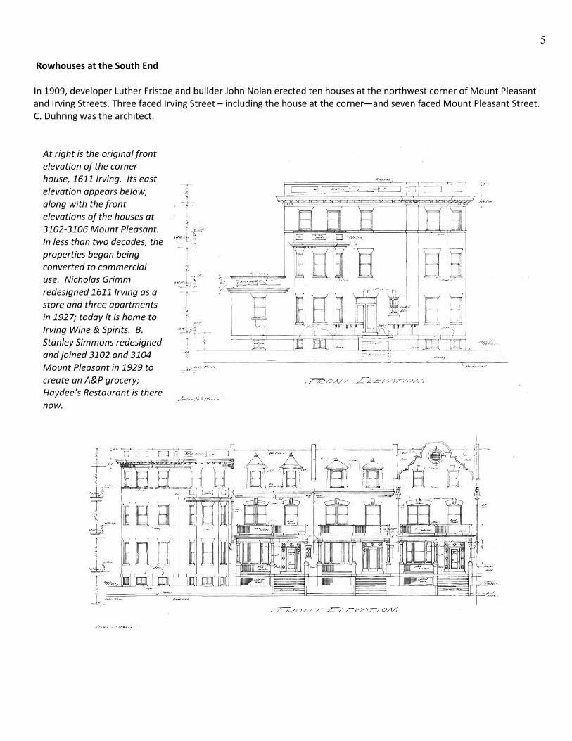
Rowhouses at the South End In 1909, developer Luther Fristoe and builder John Nolan erected ten houses at the northwest corner of Mount Pleasant and Irving Streets. Three faced Irving Street – including the house at the corner—and seven faced Mount Pleasant Street. C. Duhring was the architect.
At right is the original front elevation of the corner house, 1611 Irving. Its east elevation appears below, along with the front elevations of the houses at 3102-3106 Mount Pleasant. In less than two decades, the properties began being converted to commercial use. Nicholas Grimm redesigned 1611 Irving as a store and three apartments in 1927; today it is home to Irving Wine & Spirits. B. Stanley Simmons redesigned and joined 3102 and 3104 Mount Pleasant in 1929 to create an A&P grocery; Haydee’s Restaurant is there now.

6
The block was completed in 1910 and 1911 with eight more rowhouses, all designed by architect William C. Allard. 3116-3120 Mount Pleasant were developed by H. M. Dante, and the remaining five by Francis A. Blundon. Like the other houses on the block, these eventually succumbed to commercial pressure. The Blundon houses were razed in 1937 to make way for a Gulf Oil filling station. The three Dante houses remained private residences through World War II, then became the sites for a series of small businesses including the Friendly Laundry and Harry’s Repair Shop. Dos Gringos Café occupies 3116 Mount Pleasant today.
3116-3130 Mount Pleasant as the houses appeared in 1911.The drawing of the five houses on the right was recreated from an original in the National Archives. More Stores In 1911, Annie and Louis Steerman – who had just built two stores across from the streetcar terminus—erected a row of five stores south of Irving Street at 3062-3070 Mount Pleasant. As shown below, the architect A.S.J. Atkinson designed a cohesive row of traditional storefronts with a continuous cornice and uniform windows and doors. A few years later, they were joined by stores at 3054 and 3056, completing the commercial streetscape in that block. The buildings at 3054 have been devoted to this day to servicing automobiles, while the other spaces have hosted a variety of businesses.

7
In 1912, architect Nicholas T. Haller provided prolific builder Charles W. King with a design for four one-story stores at 3159-3165 Mount Pleasant, as well as three houses at 1620-1624 Lamont that backed up to them. In the process of construction, the commercial buildings grew to two stories with apartments over the stores.
This was the original design for 3159-3165 Mount Pleasant Street. In 1914, Thomas Armat, a real estate operator and inventor, acquired the small block bounded by Mount Pleasant, Lamont, and 17th Streets and Kilbourne Place. Over the next 14 years, he erected a group of nine individual stores that provided continuous storefronts around the entire block. The first store was a Sanitary Grocery at the corner of Mount Pleasant and Lamont, and grocery stores have remained the primary business conducted at this location since then. The Sanitary later absorbed the adjacent Piggly Wiggly and in 1942 became part of the Safeway chain. A variety of other businesses have operated within the complex, perhaps the most unusual being an indoor miniature golf course in 1931. Armat is best known as the developer of the first practical motion picture projector, for which he was awarded a special Oscar shortly before his death in 1948. He also opened the first commercial movie theatre in downtown Washington. His family owned the Mount Pleasant property until 1971. Since 1984, it has been the site of the Bestway (and now Bestworld) supermarket. Don Juan’s Restaurant occupies the original portion of the complex.
The Mount Pleasant Street facade of the Armat complex may have originally looked like this.

8
Serving the Neighborhood As this brief history shows, the Mount Pleasant commercial corridor is notable both for the prominence of the architects and developers who built it as well as the richly-detailed and attractive streetscape they created. The businesses that occupied the 70 or more commercial spaces constructed between 1906 and 1938 focused on meeting the basic needs of neighborhood residents and their households. Not surprisingly, the most prevalent types of businesses were related to food and clothing. By 1940, over one-third of the spaces had housed grocery stores; another 8, delicatessens; 4, bakers or confectioners, and 3, restaurants. Clothing-related businesses were dominated by tailors, launderers, “clothes cleaners,” and “dyers.” By 1940, 20 commercial spaces in the corridor had housed such businesses for some period of time. There had also been 9 “ladies tailors” or dressmakers, 3 milliners, and 7 locations with shoemakers. To these were added an array of barbers and beauticians, pharmacies and gas stations, notions and gift shops, and various specialty businesses. A database compiled from city directories showing the businesses listed at each address, presently covering in detail the period from 1914 to 1943, is available on our website. Compare the 1919 Baist map to the left to the one on the front cover to see how quickly Mount Pleasant Street filled in once development began in earnest after 1903. The last building to be erected, the store south of The Mount Pleasant now housing El Pollo Sabroso, came in 1938. With a few exceptions, these buildings remain standing and constitute a significant part of our architectural heritage as a neighborhood. Funds for the DC Community Heritage Project are provided by a partnership of the Humanities Council of Washington, D.C., an affiliate of the National Endowment for the Humanities, and the D.C. Historic Preservation Office, which supports people who want to tell stories of their neighborhoods and communities by providing information, training, and financial resources. This D.C. Community Heritage Project has been also funded in part by the U.S. Department of the Interior, the National Park Service Historic Preservation Fund grant funds, administered by the D.C. Historic Preservation Office and by the D.C. Commission on the Arts and Humanities. This program has received Federal financial assistance for the identification, protection, and/or rehabilitation of historic properties and cultural resources in the District of Columbia. Under Title VI of the Civil Rights Act of 1964 and Section 504 of the Rehabilitation Act of 1973, the U.S. Department of the Interior prohibits discrimination on the basis of race, color, national origin, or disability in its federally assisted programs. If you believe that you have been discriminated against in any program, activity, or facility as described above, or if you desire further information, please write to: Office of Equal Opportunity, U.S. Department of the Interior, 1849 C Street, N.W., Washington, D.C. 20240.

9