the ancestral salt flat graben. alternative paleozoic history of the sierra diablo and apache...
TRANSCRIPT

The Ancestral Salt Flat Graben. Alternative Paleozoic History
of the Sierra Diablo and Apache
Mountains, Trans Pecos, West Texas.
Robert C. Trentham Robert C. Trentham
CEED/Univ. Texas of the CEED/Univ. Texas of the Permian BasinPermian Basin

“Thus, the present Sierra Diablo appears
to have been a positive through
much of its history.”P. B. King, 1942, p. 614
Acknowledgements
University of Texas of the Permian BasinUniversity of Texas of the Permian BasinBob Lindsay, Chevron – ConsultantBob Lindsay, Chevron – ConsultantBob Ward Bob Ward Al SmithAl SmithHughes Family – Apache RanchHughes Family – Apache Ranch

After King (1965)
West Texas Physiographic Features
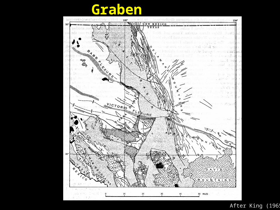
After King (1965)
Salt Flat Graben

An Ancestral Salt Flat Graben Can Explain:
The location of the western The location of the western boundary of the Tobosa Basinboundary of the Tobosa Basin
Wolfcampian and Leonardian shelf Wolfcampian and Leonardian shelf margins in the Sierra Diablo’smargins in the Sierra Diablo’s
A lack of Siliciclastics in the upper A lack of Siliciclastics in the upper Guadalupian in the Apache Guadalupian in the Apache MountainsMountains
The location of the Ochoan The location of the Ochoan “Western Marine Channel”“Western Marine Channel”
The presence of a separate The presence of a separate Apache PlatformApache Platform
Issues
The Salt Flat Graben is not solely The Salt Flat Graben is not solely a Basin and Range Feature. a Basin and Range Feature.
The eastern boundary faults of The eastern boundary faults of the Sierra Diablo, Beach, Carrizo the Sierra Diablo, Beach, Carrizo and Van Horn Mountains have and Van Horn Mountains have had a complex history and were had a complex history and were active periodically during the active periodically during the Paleozoic. Paleozoic.
The Ancestral Graben controlled The Ancestral Graben controlled regional deposition throughout regional deposition throughout the Paleozoic. the Paleozoic.

Lack of Evidence
The position of the The position of the Guadalupian Shelf Margin Guadalupian Shelf Margin between the Guadalupe and between the Guadalupe and Apache Mountains is unknownApache Mountains is unknown
The exact location of the The exact location of the Ochoan age western channel Ochoan age western channel connecting the Delaware Basin connecting the Delaware Basin and the Marfa Basin/Permian and the Marfa Basin/Permian Ocean is unknownOcean is unknown

Evidence Western margin of the Tobosa Basin is coincident with Western margin of the Tobosa Basin is coincident with
the eastern boundary fault of the Sierra Diablo Uplift.the eastern boundary fault of the Sierra Diablo Uplift. The eastern boundary fault of the Sierra Diablo Uplift was The eastern boundary fault of the Sierra Diablo Uplift was
active during lower Hueco (l. Wolfcampian) as there is active during lower Hueco (l. Wolfcampian) as there is evidence of thick Powwow Conglomerate in the Basin evidence of thick Powwow Conglomerate in the Basin
The Wolfcampian in the Sierra Diablo Range appears to The Wolfcampian in the Sierra Diablo Range appears to have been composed of a series of isolated platforms have been composed of a series of isolated platforms which shed debris in the Basinwhich shed debris in the Basin
The location of the Leonardian shelf margins, at the north The location of the Leonardian shelf margins, at the north end of the Sierra Diablo Range, appears to have been end of the Sierra Diablo Range, appears to have been controlled by the position of the Sierra Diablo Fault and controlled by the position of the Sierra Diablo Fault and Babb FlexureBabb Flexure

Evidence
There is a lack of thick siliciclastics in the There is a lack of thick siliciclastics in the Guadalupian section in the Apache Guadalupian section in the Apache Mountains which needs to be explained.Mountains which needs to be explained.
The presence of Super Mature sand in the The presence of Super Mature sand in the upper Munn in the Apache Mountains upper Munn in the Apache Mountains indicates the presence of a local Ordovician indicates the presence of a local Ordovician sourcesource
Fault trends in the Baylor Mountains are Fault trends in the Baylor Mountains are different than in the surrounding rangesdifferent than in the surrounding ranges

Lower Paleozoic of West Texas
Trans Trans PecosPecos
Delaware Delaware BasinBasin
u. Mississippianu. Mississippian Helms Fm.Helms Fm.
Miss. LimeMiss. LimeBarnett Fm.Barnett Fm.
Miss LimeMiss Lime
l. Mississippianl. Mississippian Percha ShalePercha Shale Woodford ShaleWoodford Shale
DevonianDevonian Siluro-DevonianSiluro-Devonian Thirtyone Fm.Thirtyone Fm.
u. Silurianu. Silurian Siluro-DevonianSiluro-Devonian Wristen Fm.Wristen Fm.
l. Silurianl. Silurian Fusselman Fm.Fusselman Fm. Fusselman Fm.Fusselman Fm.
u.Ordovicianu.Ordovician Montoya Fm.Montoya Fm. Montoya Fm.Montoya Fm.
m. Ordovicianm. Ordovician [ Simpson Group ][ Simpson Group ] Simpson GroupSimpson Group
l. Ordovicianl. Ordovician El Paso GroupEl Paso Group Ellenburger GroupEllenburger Group
Cambro-OrdCambro-Ord Bliss SS.Bliss SS. Wilberns SS.Wilberns SS.
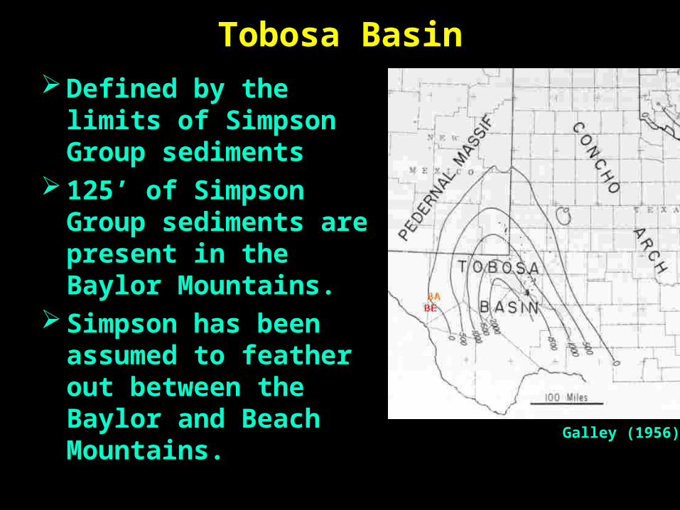
Tobosa Basin Defined by the limits Defined by the limits
of Simpson Group of Simpson Group sedimentssediments
125’ of Simpson 125’ of Simpson Group sediments are Group sediments are present in the Baylor present in the Baylor Mountains. Mountains.
Simpson has been Simpson has been assumed to feather assumed to feather out between the out between the Baylor and Beach Baylor and Beach Mountains.Mountains.
Galley (1956)
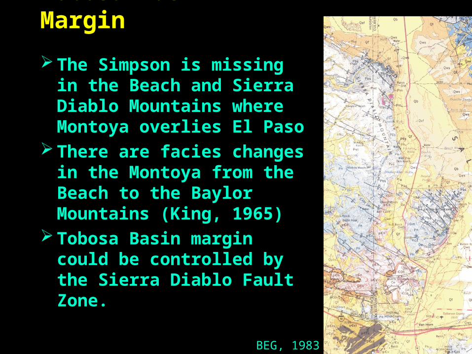
Tobosa Basin Margin
The Simpson is missing The Simpson is missing in the Beach and Sierra in the Beach and Sierra Diablo Mountains where Diablo Mountains where Montoya overlies El PasoMontoya overlies El Paso
There are facies changes There are facies changes in the Montoya from the in the Montoya from the Beach to the Baylor Beach to the Baylor Mountains (King, 1965) Mountains (King, 1965)
Tobosa Basin margin Tobosa Basin margin could be controlled by could be controlled by the Sierra Diablo Fault the Sierra Diablo Fault Zone. Zone.
BEG, 1983

Upper Paleozoic StratigraphyApache / Sierra DiabloApache / Sierra Diablo Delaware BasinDelaware Basin
OchoanOchoan CastileCastile Salado/CastileSalado/Castile
u. Guadalupian u. Guadalupian
m. Guadalupianm. Guadalupian
TansillTansillYatesYatesSeven RiversSeven RiversGoat SeepGoat Seepu. Munn (Queen) u. Munn (Queen) l. Munn (Grayburg)l. Munn (Grayburg)
Lamar LimeLamar LimeBell Canyon Bell Canyon
Cherry CanyonCherry Canyon
l. Guadalupianl. Guadalupian San AndresSan Andres Brushy CanyonBrushy Canyon
u. Leonardianu. Leonardian Cutoff Fm. Cutoff Fm. Victorio Peak Fm.Victorio Peak Fm.
Cutoff Fm. Cutoff Fm. Victorio Peak Fm.Victorio Peak Fm.
m. Leonardianm. Leonardian Clear ForkClear Fork Bone SpringsBone Springsl. Leonardianl. Leonardian AboAbo Bone SpringsBone Springsu. Wolfcampu. Wolfcamp HuecoHueco HuecoHuecou. Wolfcampu. Wolfcamp PowwowPowwow PowwowPowwow

Powwow Conglomerate Thickness
OPERATOR WELL POWWOW SUBCROPMcBay #1 Strasser 2280 PCMBDavis, Armour & West #1 Davis 570 to >2450 ???Gulf #1 Grisham 742 BARNETTLaGloria #1 Stansberry 40 MONTOYAHumble* #1-B Reynolds 50 SIMPSONGulf #1-C Foster 160' WRISTENSunray* #1 J.B.Foster 210' MONTOYAContinental #1 Foster 230' MONTOYACanter, Hamm & O'Brien #1 Foster 230' WOODFORDCosden #1 Cockrell 280' PCMBOutcrop 0 - 300' VARIOUS
In outcrop and subsurface, the Powwow Conglomerate (lower Hueco) In outcrop and subsurface, the Powwow Conglomerate (lower Hueco) is nowhere thicker than 300’is nowhere thicker than 300’

Powwow Conglomerate Except Except in the three wells in the three wells
which penetrate the Hueco which penetrate the Hueco in the Graben:in the Graben:
McBay #1 StrasserMcBay #1 StrasserDavis, Armour & Davis, Armour &
West West #1 Davis#1 DavisGulf #1 GrishamGulf #1 Grisham
in these wells, there are in these wells, there are from 742 to >2450’ of from 742 to >2450’ of debris.debris.
Conclusion: The only three Conclusion: The only three wells in the Graben wells in the Graben indicate Permo-Penn indicate Permo-Penn movementmovement on the Graben on the Graben MarginMargin
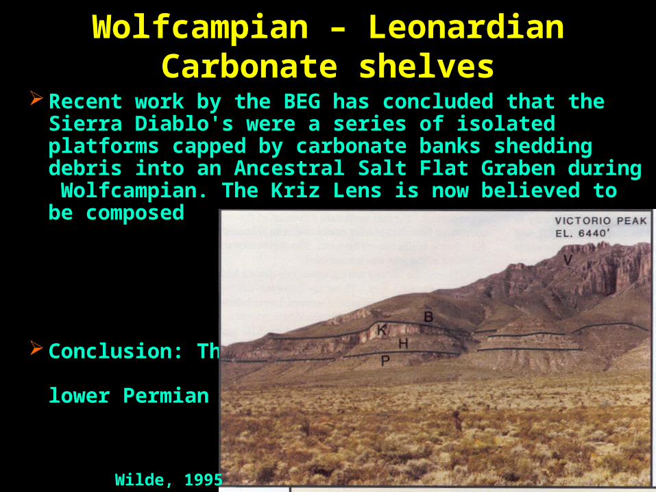
Wolfcampian – Leonardian Carbonate shelves
Recent work by the BEG has concluded that the Sierra Recent work by the BEG has concluded that the Sierra Diablo's were a series of isolated platforms capped by Diablo's were a series of isolated platforms capped by carbonate banks shedding debris into an Ancestral Salt Flat carbonate banks shedding debris into an Ancestral Salt Flat Graben during Wolfcampian. The Kriz Lens is now believed Graben during Wolfcampian. The Kriz Lens is now believed to be composed to be composed of a series of of a series of carbonate carbonate debris flows. debris flows.
Conclusion: The Conclusion: The Graben existed Graben existed during the during the lower lower Permian Permian
Wilde, 1995

Wolfcampian – Leonardian Carbonate shelves
The location of the Leonardian shelf margin, at the north end of the The location of the Leonardian shelf margin, at the north end of the Sierra Diablo Range, appears to have been controlled by the position Sierra Diablo Range, appears to have been controlled by the position
of the Sierra Diablo Fault and Babb Flexureof the Sierra Diablo Fault and Babb Flexure
Fitchen 2000
Sierra Diablo –A Low Relief Highland
There is evidence of a Sierra Diablo There is evidence of a Sierra Diablo positive/Salt Flat Graben negative positive/Salt Flat Graben negative during middle and upper Ordovician, during middle and upper Ordovician, Wolfcampian and Leonardian Wolfcampian and Leonardian
During the Guadalupian where was the During the Guadalupian where was the shelf margin? The only Guadalupian in shelf margin? The only Guadalupian in the range is “back reef” Goat Seep the range is “back reef” Goat Seep north of the Babb Flexure (King,1965). north of the Babb Flexure (King,1965). Was there ever any Guadalupian Was there ever any Guadalupian present in the Sierra Diablo's?present in the Sierra Diablo's?
and Ochoan…and Ochoan…
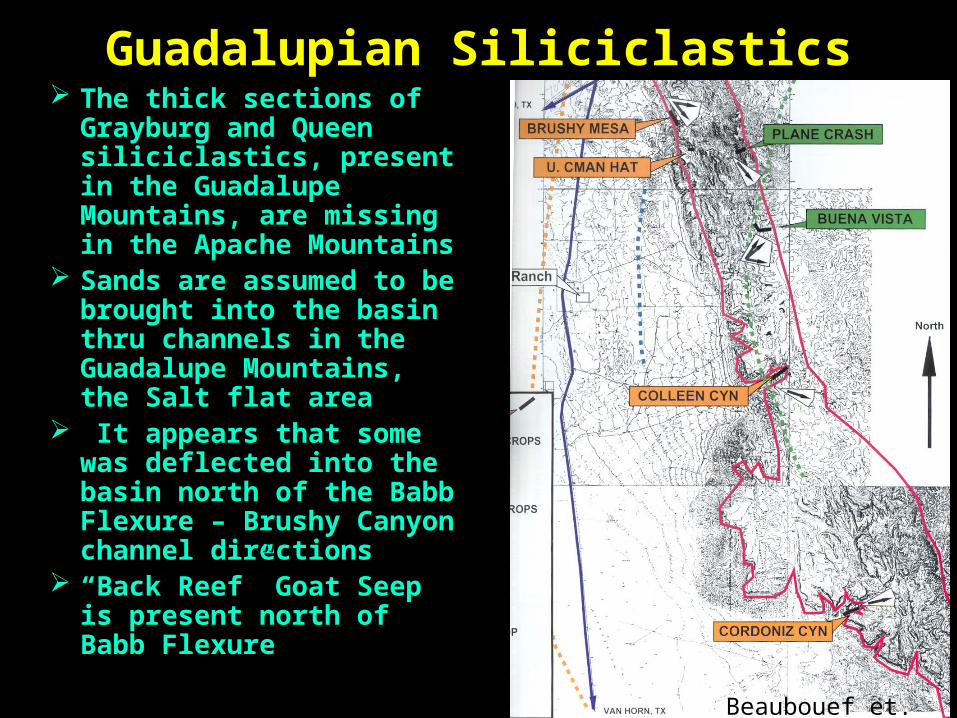
Guadalupian Siliciclastics The thick sections of The thick sections of
Grayburg and Queen Grayburg and Queen siliciclastics, present in the siliciclastics, present in the Guadalupe Mountains, are Guadalupe Mountains, are missing in the Apache missing in the Apache MountainsMountains
Sands are assumed to be Sands are assumed to be brought into the basin thru brought into the basin thru channels in the Guadalupe channels in the Guadalupe Mountains, the Salt flat areaMountains, the Salt flat area
It appears that some was It appears that some was deflected into the basin north deflected into the basin north of the Babb Flexure – Brushy of the Babb Flexure – Brushy Canyon channel directionsCanyon channel directions
““Back Reef” Goat Seep is Back Reef” Goat Seep is present north of Babb Flexure present north of Babb Flexure
Beaubouef et. al. 1999
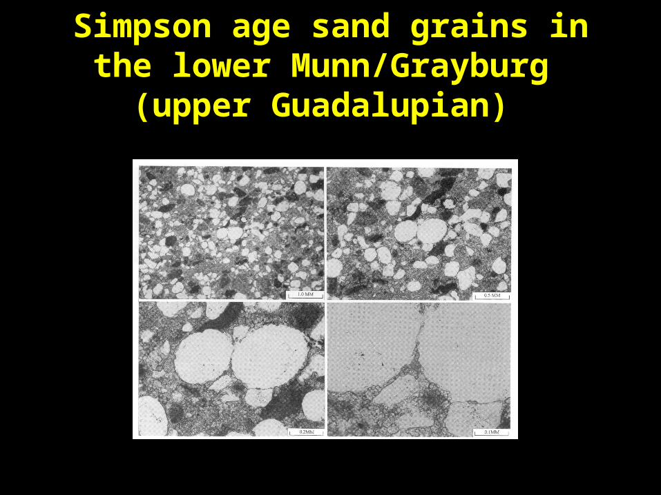
Simpson age sand grains in the lower Munn/Grayburg
(upper Guadalupian)
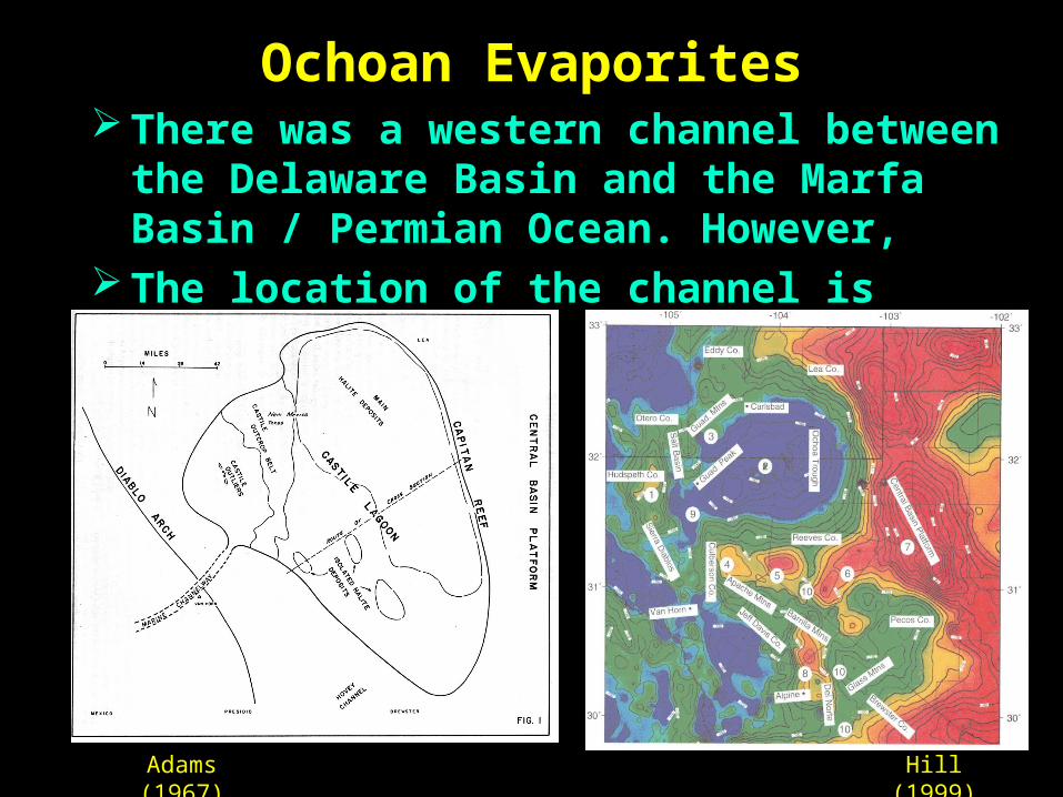
Ochoan Evaporites There was a western channel between There was a western channel between
the Delaware Basin and the Marfa the Delaware Basin and the Marfa Basin / Permian Ocean. However,Basin / Permian Ocean. However,
The location of the channel is The location of the channel is conjecturalconjectural
Adams (1967)
Hill (1999)
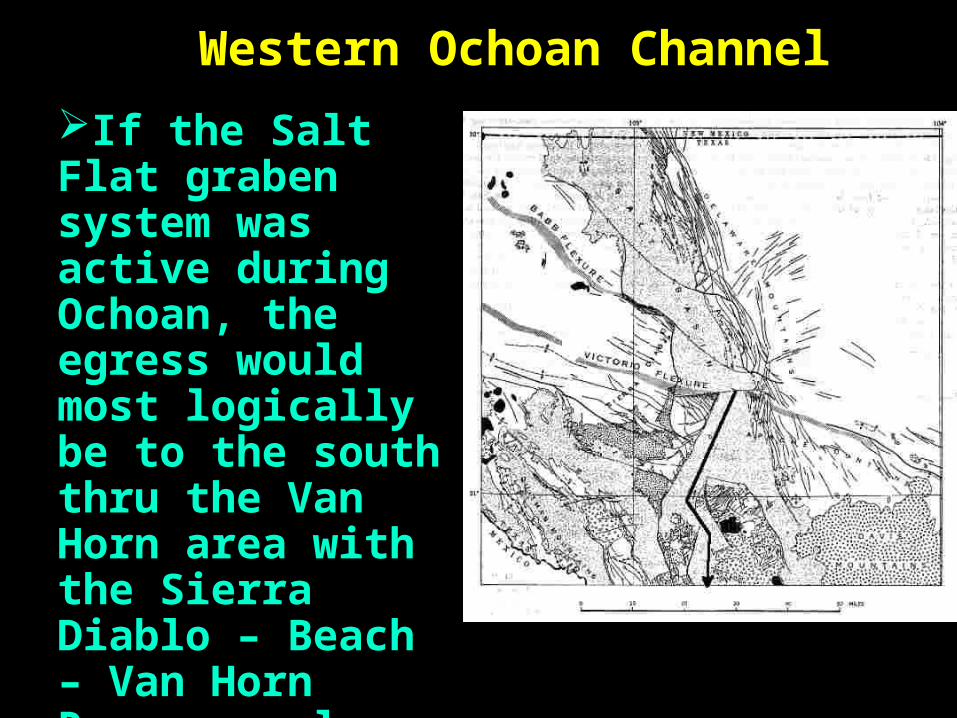
Western Ochoan Channel
If the Salt Flat graben If the Salt Flat graben system was active system was active during Ochoan, the during Ochoan, the egress would most egress would most logically be to the south logically be to the south thru the Van Horn area thru the Van Horn area with the Sierra Diablo – with the Sierra Diablo – Beach – Van Horn Beach – Van Horn Ranges as low relief Ranges as low relief highlands to the west highlands to the west and the Apache and and the Apache and Wylie Mountains to the Wylie Mountains to the easteast

A Separate Apache Platform The lack of siliciclastics The lack of siliciclastics
in Apache Mountainsin Apache Mountains Periodic rejuvenation of Periodic rejuvenation of
the eastern boundary the eastern boundary faults of the Sierra faults of the Sierra Diablo – Beach – Van Diablo – Beach – Van Horn Mountains and Horn Mountains and subsequent graben subsequent graben developmentdevelopment
Ochoan outlet to Marfa Ochoan outlet to Marfa BasinBasin
SummaryEvidence of an Ancestral Salt Evidence of an Ancestral Salt
Flat Graben is found Flat Graben is found throughout the Paleozoic in:throughout the Paleozoic in:Simpson and Montoya age Simpson and Montoya age
Tobosa Basin marginTobosa Basin marginPowwow ConglomeratePowwow ConglomerateWolfcamp and Leonard shelf Wolfcamp and Leonard shelf
margins margins Guadalupian siliciclasticsGuadalupian siliciclasticsOchoan ChannelOchoan Channel

Thank You