the 113 calhoun st. project: making homes more resistant to flood, wind and...
TRANSCRIPT

Coasts at the MillenniumProceedings of the 17th International Conference ofThe Coastal Society, Portland, OR USA
125
THE 113 CALHOUN ST. PROJECT:MAKING HOMES MORE RESISTANT TO FLOOD, WIND AND
EARTHQUAKE
Elizabeth K. Judge, S.C. Sea Grant Extension ProgramRobert H. Bacon, S.C. Sea Grant Extension Program
Charleston, South Carolina
Abstract
113 Calhoun Street: A Center for Sustainable Living is a public/privatepartnership focused on minimizing threats to public health and safety fromnatural hazards, and encouraging the conservation of natural resources. Theproject serves as a link between the research lab and the community, bringingscience-based solutions to hazard loss reduction in residential structures. Weaddress flood, wind, and earthquake hazards through both structural and non-structural retrofit techniques including a seismically resistant foundation; floodproofing; improved roof attachment; and a range of window protectionalternatives, such as storm shutters and impact resistant glass. Audiences forthis information include building design and construction professionals,technical and vocational educators and students, building officials, insurers,lenders, and homeowners.
Background
113 Calhoun Street: A Center for Sustainable Living is a public/privatepartnership focused on minimizing threats to public health and safety fromnatural hazards, and encouraging the conservation of natural resources. TheCenter’s overall mission will be accomplished by low-cost tools and techniques,educational activities, and technical assistance programs in three areas:(1) Natural Hazard Mitigation strategies to minimize loss of life and property
from the flood, wind, and earthquake events;(2) Sustainable Building Practices involving energy and water conservation,
sustainable landscaping, recycled and sustainable building materials, andconstruction waste reduction and recycling; and
(3) Sustainable Living, including household hazardous waste management,home pest control, indoor air and water quality, and recycling.
This paper will focus on (1) Natural Hazard Mitigation strategies.
The Center is located in a former residence in historic Charleston, SouthCarolina (Figure 1), now completely renovated and open to the public.

126
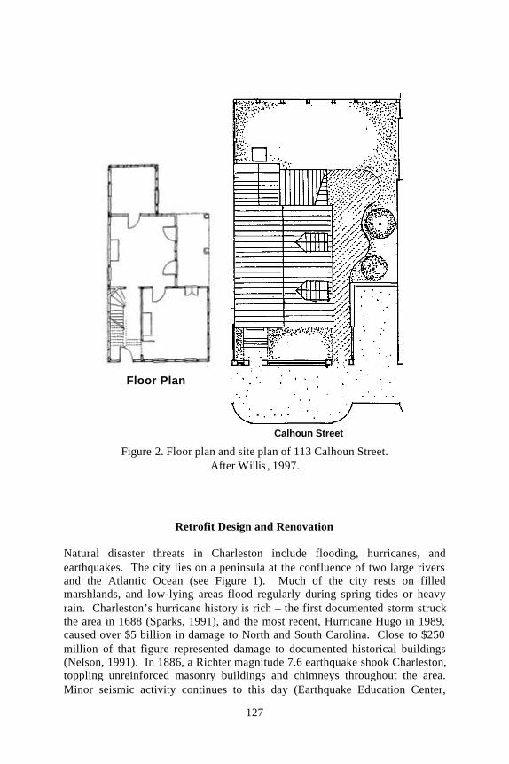
The structure at 113 Calhoun is built in the traditional “Charleston single house”style. While the original “single house” design has a door that leads onto theporch, or piazza, 113 Calhoun’s design is a typical variation with a door leadingdirectly into the house (Figure 2). The house, constructed between 1875 and1880, is located within the boundaries of Charleston’s historic district. TheCharleston Board of Architectural Review (BAR) must approve any renovationof the structures within the district. The building suffered extensive roofdamage during Hurricane Hugo, and was in extreme disrepair when the City ofCharleston donated it at the Center for Sustainable Living project’s inception.
A design team – consisting of an architect, consulting engineers, researchengineers, and a general contractor – planned and managed the building’sretrofit. They chose solutions and materials using consensus agreement – aunique approach in a field where the architect often designs the project, theengineer specifies technical details, and the builder executes the plan. Thiscooperation facilitated a very practical design that met engineeringspecifications as well as architectural requirements in the historic district.
113 Calhoun
Figure 1. Location of 113 Calhoun Street in historic Charleston
127
Retrofit Design and Renovation
Natural disaster threats in Charleston include flooding, hurricanes, andearthquakes. The city lies on a peninsula at the confluence of two large riversand the Atlantic Ocean (see Figure 1). Much of the city rests on filledmarshlands, and low-lying areas flood regularly during spring tides or heavyrain. Charleston’s hurricane history is rich – the first documented storm struckthe area in 1688 (Sparks, 1991), and the most recent, Hurricane Hugo in 1989,caused over $5 billion in damage to North and South Carolina. Close to $250million of that figure represented damage to documented historical buildings(Nelson, 1991). In 1886, a Richter magnitude 7.6 earthquake shook Charleston,toppling unreinforced masonry buildings and chimneys throughout the area.Minor seismic activity continues to this day (Earthquake Education Center,
Floor Plan
Calhoun Street
Figure 2. Floor plan and site plan of 113 Calhoun Street.After Willis , 1997.

128
2000). A 1999 mapping effort by Risk Management Solutions (RMS), aninternational catastrophe modeling firm, lists Charleston and San Francisco atcomparable levels of risk on a “Risk Thermometer,” measuring hurricane,earthquake, tornado, and hail threats (RMS, 2000). A summary of major naturaldisasters in the Charleston area is shown in Figure 3.
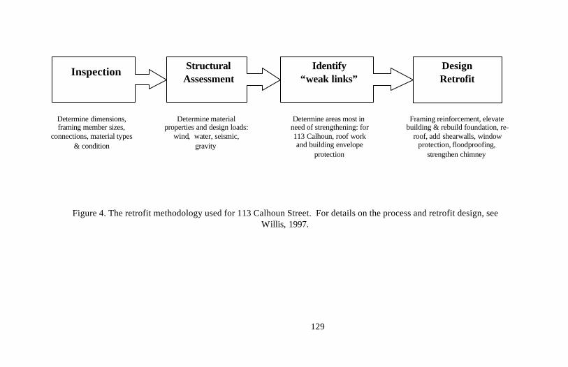
Faced with these hazards, the 113 Calhoun Street team developed a plan toretrofit the building. Willis (1997), a team member, used the process as a casestudy to develop a more general method of structural analysis and retrofit forhistoric buildings. First, the building was inspected thoroughly. Acomprehensive structural analysis helped identify priorities for retrofit, andfinally, the team executed a retrofit design (see Figure 4).
Lessons learned during the process can be summarized as follows (Willis,1997):
• Retrofit is subjective: calculations do not tell the whole story andthe numbers must be placed in the proper context;
• Often, significant benefit can be realized even if the retrofitstructure is not brought into full code compliance; and
• A single retrofit solution does not exist.
Figure 3. Timeline of Charleston’s hazards history. The most recent eventof note was hurricane Hugo in 1989. After W illis, 1997.
129
Inspection StructuralAssessment
Identify“weak links”
DesignRetrofit
Determine dimensions,framing member sizes,
connections, material types& condition
Determine materialproperties and design loads:
wind, water, seismic,gravity
Determine areas most inneed of strengthening: for113 Calhoun, roof workand building envelope
protection
Framing reinforcement, elevatebuilding & rebuild foundation, re-
roof, add shearwalls, windowprotection, floodproofing,
strengthen chimney
Figure 4. The retrofit methodology used for 113 Calhoun Street. For details on the process and retrofit design, seeWillis, 1997.

130
The project’s construction phase is now complete. Figure 5 shows 113 CalhounStreet before and after renovation.
Figure 5. (a) 113 Calhoun in 1995, and (b) now.Structural and interior retrofit and renovationare complete and the building is ready tofunction as a demonstration site and laboratory.

131
Education Programs and Partnerships
The 113 Calhoun Street Center is the focal point of a coordinated program ofhazards-related education, demonstration, and technology transfer. It serves asthe primary channel for the dissemination of research results from Sea Grant-supported and other research on hazard resistant construction. Educationalprograms for diverse user groups such as design professionals, the buildingindustry, local building officials, and homeowners are currently underdevelopment – and implementation is ongoing.
The Center is already playing a role in local, regional, and national hazardmitigation education.• In 1999, 113 Calhoun Street became a local Project Impact partner, serving
as an important educational element in local mitigation programs, includingboth the State of South Carolina’s and City of Charleston’s FloodMitigation education plans. Staff working with the Center are alsoparticipating in the NeighborWorks Homeownership Center’s program toretrofit homes in four low-income neighborhoods in Charleston and NorthCharleston for greater resistance to high winds. Training programs for localHabitat for Humanity affiliates are planned for late July 2000.
• Statewide training for Clemson Extension housing agents, buildingprofessionals, and code enforcement officials took place in May 2000, and astatewide course for real estate agents is planned for 2001.
• Regionally, the Center has recently hosted groups from the New York StateEmergency Management Office and Long Island Project Impact, who areconsidering building their own retrofit model home, and fromrepresentatives from several southeastern states’ energy offices, who planoutreach projects for their communities.
• On the national level, the CBS Morning News featured the Center, as didBob Vila’s “Home Again” program on The Learning Channel, describing toviewers how homes can be made more resistant to wind, flood andearthquake hazards.
• In 1998, the 113 Calhoun Street Foundation received the John R. ShaefferAward for “Excellence in Flood Proofing” from the Association of StateFlood Plain Managers, the national organization of flood managementprofessionals.
Conclusions
The Center at 113 Calhoun Street is a resource not only for South Carolina, butis also a source of information for hazard mitigation experts nationwide.

132
Communities with historic resources, especially those with hurricane risk, canlook to the Center’s work and formulate their plans for preserving historicproperties. Homeowners planning to build in coastal areas can also findinformation and resources that detail recommendations for new construction.The Web site, <www.113calhoun.org>, reaches homeowners and buildingprofessionals throughout the country.
Acknowledgements
The 113 Calhoun Street project is a partnership of the S.C. Sea GrantConsortium, Clemson University Extension Service, the City of Charleston, theSouth Carolina Emergency Preparedness Division, and Charleston County. TheFederal Emergency Management Agency (FEMA) provided major funding.Donors include: Alcoa Mt. Holly; Ashton Phillips, Individual Contributor; BellSouth; Berkeley Electric Cooperative, Inc.; C.J. Cantwell, Architect; CoastalLandscape Construction; Design Works; Duron Paints and Wallcoverings;HurriSAFE; ITW Foamseal, Inc.; Ilderton Contractors, Inc.; Joanna Foundation;Ketner Fund; National Trust for Historic Preservation; Nite Light; ParsonsNursery; Paverscape Design Group; SCANA Corporation; Shoolbred Engineers,Inc.; Shutter Systems, Inc.; Simmons Irrigation Supply, Inc.; Simpson Strong-Tie, Inc.; Solutia, Inc.; S.C. Association for Hazard Mitigation; S.C. EnergyOffice; S.C. Farm Bureau Insurance Companies; State Farm Fire and CasualtyCompany; Terminix, Inc.; Unicon Concrete; Vista Doors and Windows / Kolbe& Kolbe; Weather Guard Hurricane Protection, Inc.; and Windward HurricaneShutters.
References
Earthquake Education Center, Charleston Southern University (2000)Frequently Asked Questions.<http://www.csuniv.edu/Academics/Quake/eecb.html>.
Nelson, C. L. (1991) Protecting the Past from Natural Disasters. ThePreservation Press, Washington, D.C. 192 p.
Risk Management Solutions (2000) Catastrophic Risk Map of the UnitedStates: Earthquake, Hurricane, Tornado and Hail. RMS, Inc., Menlo Park,California.
Sparks, P. R. (1991) Development of the South Carolina coast 1959 –1989: Prelude to a disaster, in Hurricane Hugo One Year Later, B. L. Sill and P.R. Sparks, Eds. ASCE, New York, New York. pp. 1-7.
Willis, V. (1997) The Development of Structural Evaluation and RetrofitMethodologies for Historic Charleston Homes. Master’s thesis, ClemsonUniversity Dept. of Civil Engineering. 165 p.

133
Elizabeth K. JudgeCoastal Hazards SpecialistS.C. Sea Grant Extension ProgramClemson Dept. of Civil Engineering287 Meeting St.Charleston, S.C. 29401 USAPhone: (843) 727-2078Fax: (843) 727-2080Email: [email protected] Calhoun Street web site: www.113calhoun.org

Coasts at the MillenniumProceedings of the 17th International Conference ofThe Coastal Society, Portland, OR USA
134
ALTERNATIVES TO BULKHEADS IN THE PUGET SOUND REGION:WHAT IS SOFT SHORE PROTECTION? WHAT IS NOT?
Jim Johannessen MS, Coastal Geologic Services, Inc.
Introduction
Beach erosion and improper development along the shore have been the norm inPuget Sound and the Northwest Straits. Traditional “hard” bulkheading(seawalls) has been the usual response to this situation until very recently, when“soft shore protection” alternatives have been encouraged by regulators andwell-informed citizens. Soft shore protection (SSP) projects rebuild the high-tidebeach to provide protection of property and homes and increase coastalsediment supply, the foundation of our sediment-starved coastal systems. Softshore protection in the Puget Sound region has typically entailed the use ofindigenous materials such as gravel, sand, logs, and root masses to absorb waveenergy. Wolf Bauer designed many SSP projects since the 1970s, with manySeattle Park projects and numerous constructed beaches in Puget Sound andBritish Columbia. These projects usually consisted of large gravel beachnourishment projects that were not monitored and remain very poorlydocumented.
A key factor that defines soft shore protection is designed flexibility, in order tomimic natural processes. For example, an enhanced gravel berm providesprotection against storm waves due to the ability of a gravel berm to reshapeitself in a way to dissipate wave energy. Incoming wave water is absorbed by agravel berm, which then percolates out gradually. This is in direct contrast to asolid bulkhead. Although quantitative research on the impacts of “hardstructures” on beaches is scarce, bulkheads have been shown to reflect waveswithout dissipating wave energy, and causing beach scour and focusing waveenergy and erosion onto adjacent beach and backshore areas (Macdonald, et al.1994). Bulkheads also cause a number of cumulative negative impacts to coastalsystems (Pilkey 1988) including sediment “starvation”, loss of beach area,sediment size increase, and loss of bluff and backshore vegetation. Thesephysical changes to beach systems often result in increased erosion rates,increased incidence of coastal flooding, and the perpetuation of bulkheading asthe all too common “domino effect” occurs along our shores. For example, recentstudies documented that extensive shoreline modification has occurred alonglocal shores (Table 1).

135
Table 1. Percent of upper beach shore with extensive modification (primarilybulkheaded).
Area Amount of Shore Extensively ModifiedE Main Basin of Puget Sound 79 %Skagit County (N Puget Sound) 34 %Whidbey Island 22 %
Nearshore Habitat Issues
“Traditional” bulkheads have been shown to lead to tremendous degradation ofbeach and nearshore habitat across the region (Thom et al. 1994). The cumulativenegative impacts of bulkheads on nearshore and backshore areas in the PugetSound region is only beginning to be understood. Impacts to habitat used bypacific salmon, forage fish (important salmon food sources), and other organismsare now being investigated. Negative ecological impacts on Puget Sound areanearshore habitats due to site specific and cumulative impacts of bulkheadinginclude reduction of the following habitat features:
♦ Surf smelt and sand lance (forage fish) habitat♦ Overhanging vegetation (shade, cover)♦ Large woody debris (LWD)♦ Fine sediment for hardshell clams♦ Migratory corridor for salmon♦ Eelgrass beds (likely)♦ Amount of epibenthic prey items
Resource managers were unable to significantly slow bulkheading under currentstate laws prior to the listing of Puget Sound Chinook salmon and Hood Canalsummer chum salmon under the Endangered Species Act. There has recentlybeen a dramatic increase in attention given to SSP methods as alternatives tomarine bulkheads for nearshore & estuarine habitat/ESA reasons. Theconstruction of SSP projects has recently provided a welcome alternative to theescalation of bulkheading. SSP is now required by WA Department of Fish andWildlife and other agencies/jurisdictions at many sites in lieu of bulkheads, andrecommended by almost all agencies/jurisdictions. Yet a commonly accepteddefinition of SSP does not exist.
What is Soft Shore Protection?
Soft shore protection projects designed by Coastal Geologic Services Inc. haveranged from large beach restoration efforts to enhancement of a gravel, log, andnative plant berm fronting single-family residences. The project selection anddesign process has been key to project success. SSP designs should always be

136
based on a system-wide (drift cell) assessment of “natural” and currentconditions. Determination of the erosion rate, identification of the causes oferosion, and evaluation of wave energy are critical for determining feasibility ofSSP suitability. An examination of alternatives for a particular site is also a keyelement needed prior to continuing with a conceptual design approach. Somesites are not well suited for SSP, such as sites that have very high wave energyor a lack of upper intertidal area. In other sites, moving houses away from theshore is feasible and is the best long-term solution. For sites where SSP isdetermined feasible, projects are typically designed to “undo” some of thedamage caused by shoreline modification within a drift cell such as bulkheading,shoreline fill, construction of marinas, or gravel mining. SSP projects often have along term maintenance element. For example there may be a need for the additionof gravel (much less material that the original amount) on a 5-15 year cycle, for agravel berm project.
Smaller SSP projects have included rebuilding the upper beach to provideprotection of homes. Many projects have included large logs as a structuralelement, often anchored in place into the berm with a certain amount of flexibilityprovided by the anchoring system. Almost all projects have includedintroduction or enhancement of native shoreline vegetation into the berm topand backshore area for increased stability and aesthetic value. Some projectshave included mitigation features designed to recreate or preserve degraded surfsmelt spawning habitat.
One small SSP project was a protective berm in front of a single-family residencein eastern Jefferson County. The property was a very confined parcel thatincluded a small stream mouth immediately adjacent to the house. The propertyalso contained an illegal fill of a portion of the tidelands and a poorly constructedrock bulkhead. The stream contained spawning coho salmon that was the resultof local stream restoration efforts. However, the unstable rock and fill areathreatened to topple into the now confined stream mouth and block the upstreammigration of coho. An application for a vertical concrete bulkhead had beendenied by resource managers and as assessment of the suitability of a SSPapproach was conducted by Coastal Geologic Services Inc. The completeddesign detailed a generally 15-ft wide coarse gravel berm landward of the MHHWline. The design included 2 very large anchored logs and several 3-foot diameterrocks for stability at a small “point”. The backshore and stream mouth area wasenhanced with native dune grass, large and small woody debris.
SSP projects usually enhance fish habitat (or are neutral) while preserving orrestoring the natural functions of the shore. The most important function on acumulative basis is maintaining the integrity of net shore-drift or littoral drift.This is a specific goal of every Shoreline Management Program in the region butit is often overlooked when specific bulkhead applications are reviewed. Gravelnourishment has the extra benefit of gradually increasing coastal sediment

137
supply, which is a critical factor for our increasingly sediment-starved beaches.Many SSP offer dramatic habitat benefits over any type “traditional” structure.Logs and root masses offer increased shoreline complexity, cover, and theintroduction of organic material into the nearshore system. Enhanced (andpreserved) backshore and bluff vegetation offer increased wildlife habitat, shade,large and small woody debris production, and aesthetic value.
Examples of Soft Shore Protection Projects
A large SSP project outlined in the oral presentation was restoration of adegraded 900-foot-long beach on Blakely Island in San Juan County, NWWashington. Coastal Geologic Services designed the beach restoration project atDriftwood Beach on Blakely Island in 1998. The project was designed andconstructed for the Blakely Island Maintenance Commission, which is thecommunity group composed of the majority of island property owners. Localresidents first became aware of SSP through a free workshop on coastal landstewardship (sponsored by the Puget Sound Action Team and conducted byCoastal Geologic Services Inc.) on nearby Lopez Island. Following informalcommunity education and a feasibility study, a SSP approach was chosen overconstructing a large rock revetment for Driftwood Beach.
Driftwood Beach is located on the NE shore of Blakely Island and is the largestbeach on the island. The project was designed to greatly slow chronic beacherosion and property damage that had been occurring since gravel mining tookplace in the 1960’s. Erosion of the degraded beach accelerated between 1996 and1998. The community was growing very concerned as erosion was removing theirnarrow upland property that is their only beach access.
The Blakely Island beach restoration project was designed by Jim JohannessenMS of Coastal Geologic Services Inc. and was constructed in February and earlyMarch of 1999. The design had 3 goals:1. Protect the small community owned upland area from further erosion caused
by previous gravel mining.2. Restore the beachface and backshore to a natural condition. This included
removing fill and debris, and planting a native plant community in thebackshore area.
3. Avoid waterward migration of coarse gravel and impacts to nearshorehabitats including macro algae and eelgrass beds.
The Driftwood Beach design included a protective gravel berm waterward ofnarrow upland access area. The project length was 600 ft within a 900-ft beach.To avoid impacting the macro algae and eelgrass beds, the design includedpulling the artificial upland boundary landward by removing fill and debris,moving the road/path landward, establishing stable beach slopes, and the use ofcoarse gravel for the protective berm. Soil fill and debris was first removed from

138
the upper berm and backshore area. The imported gravel consisted of 1,600 cy(cubic yards) of washed, rounded gravel with a size range of ¾ to 4 inch. A bargeequipped with a high capacity conveyor offloaded gravel directly to the upperbeach (at high tide) without grounding. Gravel was spread to a uniform slope onthe beach face that extended up to at +12.0 ft MLLW to mimic a historic highstorm berm crest. Berm gravel feathered into the preexisting lower beach (at +3.5to +4.0 ft MLLW).
Gravel offloading to build the protective berm was only half-complete at the timeof a strong SE windstorm on March 3, 1999. Wind waves were approximately 3-4ft at the beach on that morning and a substantial storm surge occurredsimultaneously. Preliminary measured water level data revealed the storm surgeon March 3 was 2.35 feet above MHHW. The unusually high tide roughlycoincided with the period of maximum winds. This storm event causedconsiderable erosion to many beaches around the region. The completed half ofthe new gravel berm was stable on March 3 while the unprotected low bank inthe northern half of the project area underwent significant erosion and scarping.In addition, a silty plume was visible originating from the northern portion of thebeach from the bank erosion indicating transport of the eroded material. Creationof the 600-ft-long enhanced berm area was achieved in the first year.
Beach monitoring was required by all of the resource agencies that issuedpermits for the Blakely Island project. This included the US Army Corps ofEngineers, WA Dept. of Fish and Wildlife, WA Dept. of Ecology, and San JuanCounty (Johannessen 1998). Baseline beach conditions in the project area werequantified through surveying performed in January 1998. Beach profiling wasconducted in May 1999 to document beach conditions going into summerfollowing several months of initial gravel adjustment. Visual observations andlimited measurements indicated that beach adjustment had not occurred atdetectable amounts following the completion of the project in March. Beachprofiling documented that the project was constructed very close to design andthat the berm provided substantial protection from storm wave damage. The newberm augmented the resiliency of the berm that was previously depleted bygravel mining and accomplished the first project goal of protecting the smallcommunity-owned upland area without losing the natural aesthetic value of thearea.
The second goal (to restore the beach and backshore to a natural condition) wasachieved by moving the artificial upland boundary landward through removal offill and debris, moving the road/path landward, and establishing a native plantcommunity in the backshore area. Clean coarse sand was brought into thebackshore area and then locally collected native plants and seeds were planted.Community plantings occurred in the spring and summer of 1999, including theparticipation of more than 50 community members that volunteered their time onthe 4th of July. As of April 2000, the backshore planting area was thriving.

139
Species used included shore pine, native dune grass, and a variety of nativeshrubs and herbaceous plants.
Profiles at Blakely Island revealed that the beachface below +1 ft MLLW did notexperience any sedimentation since pre-project and that macro algae and eelgrasswere still present at the same elevations as pre-project. Therefore, the third goal(avoid waterward migration of coarse gravel and impacts to nearshore macroalgae and eelgrass) was met. A second brief site visit was conducted in August1999 to check for changes to the beach since May. Field measurements revealedthat the beach had not changed noticeably. One profile was measured and theplot shows that the only profile change was the addition of sand in thebackshore. Annual monitoring will continue through 2003.
What is Not Soft Shore Protection?
Soft shore protection as described in the examples presented in this paper shouldbe compared to recent projects that have been termed “soft” when in fact therewas very little about the projects that is soft. Several examples are outlined in theoral presentation. A common theme to many of these projects misnamed “soft” isa rock revetment that is covered with a “softer” material such as pea gravel orsand. Such projects may or may not include logs. These projects oftenexperience rapid loss of the cover and end up as a revetment several feetlandward or lower than it may have otherwise been located, had it not beentermed “soft”. In several cases, substantial rock revetments that were completelycovered with sand were permitted as a “berm”.
One recent project termed “soft bank shoreline” was constructed at the Tides InnMotel in Port Townsend. Two new hotel buildings were permitted forconstruction that were setback only 15 ft from the ordinary high water mark(OHWM) at a moderate wave energy site. The shoreline project involvedremoving portions of the existing riprap revetment and replacing it with a smalleramount of riprap at 4H:1V and 2H:1V slopes. The rock was then covered withcoarse sand-pea gravel mix that was to be planted with native dunegrass. Theproject was constructed to specification. However the “soft” part of the projectwas no more than a façade over a revetment and was designed unrealistically,apparently without an understanding of coastal processes at the site. The “soft”features were washed away less than a month after completion. The rockrevetment was also failing and the new trail was disappearing due to wave attack.This was a case where 1) the project was misidentified and never was “soft” and2) the project was inappropriate for the site. Additionally, the fact that the projectwas perceived as “soft bank” apparently was a key reason that the ill-advisedbuilding location was approved.

140
Defining Qualities of Soft Shore Protection
Based on analysis of a large number of shore protection and restoration projects,the following defining qualities for a SSP project are forwarded:1. Project form and function are based on natural coastal processes2. Flexibility is designed into the components3. More stable natural elements may be enhanced without resorting to the use
of hard, absolute barriers4. Natural materials are used including rounded gravel, sand, logs, root masses,
individual rocks, and native vegetation5. Designs do not rely on cross-shore structures such as drift sills unless
absolutely necessary6. Designs are site specific and cannot be used in areas other than they were
intended for
Research Needs
While SSP projects have shown excellent performance to date, most have beenpoorly documented. This trend is slowly being reversed. Coastal GeologicServices Inc. has conducted semi annual or annual quantitative monitoring at 6SSP beach areas for 2-4 years. This has involved precision surveying of keybeach features, sediment sampling, and cursory level analysis. Other largeprojects have some amount of monitoring data. However, these data weregenerally collected only to satisfy permit requirements and have not beenanalyzed comprehensively or in great detail. Also, we do not have sufficientlong-term quantitative proof of project success yet. As coastal scientists wehave much to learn in developing proven methods and in documenting habitatbenefits for the emerging field of SSP. Resource managers and coastalprofessionals receive inquiries daily for studies on SSP methods or designquestions. Despite the intuitive and partially quantified benefits of SSP, oursociety is still bulkheading the Puget Sound shore at a moderate pace despite thenegative impacts. Regulations at the local, state, and federal levels are ofteninconsistent with Endangered Species Act listings and need to be updated tofacilitate the conservation of fish habitat and ecosystem functions.
Rigorous assessment of SSP project performance including new physical andecological beach surveys at a number of old and newer projects is clearlyrequired. Studies would need to be conducted at a variety of project types andwave energy levels. This would advance the science by revealing what hasworked well and what has not in different settings. A suggested study outlineincludes the following elements:
1. Develop SSP monitoring protocol2. SSP project inventory and monitoring site selection3. Integrated 3-5 year monitoring program
141
Additionally, further research also needs to be conducted to quantify thenegative impacts of bulkheading on nearshore habitats. We cannot expect totake the shortcut to “the solution” to minimizing damage to the nearshoreenvironment without first doing our homework. Rigorous assessment of physicaland ecological processes to quantify project performance needs to be completedto bring the science to maturity.
Conclusions
Soft shore protection (SSP) is an essential element for the preservation andrestoration of our ecologically sensitive nearshore habitats in the Puget Soundregion. Alternatives to traditional bulkheading exist in the Puget Sound regionfor protection of property that do not cause negative impacts to nearshorehabitats. SSP approaches offer great potential for restoration of degraded coastalareas. The Driftwood Beach Blakely Island project outlined offers one example ofa successful SSP project that offered both erosion protection and beachrestoration. The project involved the undoing of 40 years of mismanagement ofthe beach system and the rehabilitation of a stable gravel berm and a thrivingnative plant backshore area. The Driftwood Beach project did not have thenegative impacts associated with a riprap revetment, which likely would havebeen built prior to the SSP feasibility study. Smaller SSP projects have beenconstructed as alternatives to bulkheads that have provided many benefits tonearshore habitat when compared to “traditional” shore protection methods.However, a number of projects are now misleadingly termed “soft” which arenothing more than small incremental improvements over bulkheads. In othercases, some projects fail due to unrealistic design expectations.
When properly designed, SSP preserves the littoral drift continuity and naturalcoastal system functions. Direct benefits for Pacific salmon and generalecosystem functioning can be obtained when SSP is pursued instead oftraditional bulkheads. A definition of SSP is forwarded in an attempt to allow fora critical examination of current proposals. While SSP offers great promise inmanaging our valuable nearshore resources, without a number of well-documented examples (and outreach through public education) homeowners areunderstandably reluctant to invest in soft shore protection. Regulatory methodsto check the proliferation of bulkheads need to be updated and implemented.Now that many resource managers are requiring that SSP be used at specific sitesinstead of bulkheading, an integrated assessment of the success of various SSPmethods tried to date and quantitative documentation of the impacts ofbulkheading on nearshore habitats is needed.

142
References
Johannessen, J.W., 1992, Net shore-drift of San Juan County and parts ofJefferson, Island and Snohomish counties, Washington: Shorelands and CoastalZone Management Program, WA Dept. of Ecology, Olympia, DOE Pub. No. 94-74.
Johannessen, J.W., 1998. Beach monitoring plan for protective berm-beach,Driftwood Beach, Blakely Island, Prepared for the Blakely Island MaintenanceCommission, Coastal Geologic Services Inc., Bellingham, 5 p.
Macdonald, Keith, Simpson, David, Paulsen, Bradley, Cox, Jack, and Gendron,Jane, 1994. Shoreline armoring effects on physical coastal processes in PugetSound, Washington: Coastal Erosion Management Studies, Volume 5,Shorelands Program, Washington Dept. of Ecology, Olympia, DOE Report 94-78.
Pilkey, O.H, 1988. Seawalls versus beaches, In: N.C. Kraus and O.H. Pilkey(Editors) The effects of seawalls on the beach, Journal of Coastal Research, SI 4,p 41-64.
Thom, R.M., Shreffler, D.K, and Macdonald, Keith, 1994. Shoreline armoringeffects on coastal ecology and biological resources in Puget Sound,Washington: Coastal Erosion Management Studies, Volume 7, ShorelandsProgram, Washington Dept. of Ecology, Olympia, DOE Report 94-80.
Jim JohannessenCoastal Geologic Services Inc.701 Wilson Ave.Bellingham, WA 98225-7348Phone: (360) 647-1845Fax: (360) 671-6654Email: [email protected]

Coasts at the MillenniumProceedings of the 17th International Conference ofThe Coastal Society, Portland, OR USA
143
SEA LEVEL RISE RESPONSE PLANNINGIN THE STATE OF MARYLAND
Zoë Pfahl Johnson, Maryland Department of Natural Resources
Historically, the average rate of sea level rise along Maryland’s coastline has been3-4 mm/year or approximately one foot per century. It is unsettling for coastalplanners and property owners alike, that these rates are nearly twice those of theglobal average, a result probably due to substantial land subsidence. Furthermore,current scientific research shows that continued climate change will cause anacceleration of sea level rise rates, resulting in a rise of two to three feet alongMaryland’s shores by the year 2100. As researchers have already begun detectingimpacts associated with sea level rise in the Chesapeake Bay, the threat ofsignificant change to coastal and nearshore environments is quickly becoming areality.
While the range and magnitude of sea level rise impact will vary along a particularstretch of shoreline, it is generally agreed that the primary impacts of sea level riseinclude coastal flooding, coastal erosion, wetland inundation and salt waterintrusion. These impacts pose a significant threat to the steep cliffs, wetlands andmarshes, tidal estuaries, and sandy beaches that comprise Maryland’s coastalenvironment. Low-lying coastal plains and barrier islands, such as those locatedalong Maryland’s outer coast, its coastal bays, and the low-lying eastern shore areall susceptible to erosion, flooding and inundation. Sea level rise also threatens toexacerbate and prolong the process of erosion along the developed western rim ofthe Chesapeake Bay. Perhaps most dramatic, however, is the inundation risk thatsea level rise poses to the low-lying islands and extensive marsh systems within theBay.
The vulnerability of any given coastal region to sea level rise varies according to anumber of factors including: the physical character of the coastline, populationgrowth and development patterns, and the sensitivity and adaptability of state andlocal coastal management programs. Substantial research has been directed towardanalyzing the impact of rising sea levels in Maryland. The Chesapeake Bay,Maryland’s coastal bays, and the Atlantic Coast have all been the focus of suchinvestigations. However, these studies have included only a moderate analysis ofresponse options. Additionally, there has been little subsequent effort to integratethe studies or to advance toward the implementation of response strategies.
Recognizing the need for continued advance planning, Maryland’s Coastal ZoneManagement Program began to develop a sea level rise response strategy inOctober, 1998. The objectives of the planning process included:

144
· gaining a better understanding of sea level rise and its potentialimpact along Maryland’s coastline,
· determining Maryland’s current response capability,· increasing public awareness of sea level rise and coastal hazard
issues, and· enhancing Maryland’s ability to respond to sea level rise.
Sea level rise has been referred to as the “ultimate planning challenge.” While sealevel changes have played a historic role in shaping Maryland’s coastalenvironment, understanding how to address the potential for significant, perhapsincremental, change is a difficult task. This challenge is further complicated by thebroad spectrum of coastal issues and interests involved, as well as the inherentuncertainty associated with projecting accelerated sea level rise.
Despite these challenges, coastal managers around the world have realized the needto begin advance planning for sea level rise. Consequently, a great deal of researchhas been published on the impact of sea level rise in the coastal environment, aswell as the socio-political aspects of sea level rise response. This research,including that of several state coastal zone management programs (e.g., Maine andWashington), outlines the mechanics and tools for sea level rise response planningat the state and local level and provides excellent information for any entityundertaking a similar planning process. Findings worth noting include:
· State governments have the primary responsibility fordeveloping strategies to mitigate adverse impacts associatedwith sea level rise (MLI, 1994).
· Sea level rise response strategies should be directed towardexisting and on-going coastal management issues (Klarin etal.,1990).
· Focus on likely impacts, not merely the possible (MLI 1994).
· In many cases, sea level rise vulnerability can be mitigatedby anticipatory planning at the state and local level (Pew,2000).
· Meaningful preparations can take place now, despitescientific uncertainty, by building upon current research,utilizing adaptive planning frameworks, and evaluating a rangeof sea level rise scenarios (MLI, 1994).
Keeping these findings in mind, Maryland designed its planning framework aroundthree components: (1) a characterization of impacts, categorized according toshoreline type and jurisdictional boundaries; (2) an analysis of management

145
programs and initiatives directed toward resources and uses that were likely to beimpacted by sea level rise; and (3) an on-going public outreach campaign, comprisedof one-on-one interviews, issue forums, presentations, and workshops.
Impact Analysis
Maryland’s coastline, made up of the varied landscapes of the Chesapeake Bay, thecoastal bays, and the Atlantic Coast, is highly susceptible to rising sea levels. Given the diversity of the coastline, the magnitude of impact will vary from regionto region according to physical site characteristics. Geology, topography,bathymetry, fetch, surface/ground water condition, man-made features, and thefrequency and intensity of extreme events, all affect the degree of impact over timeat a given location. As a causal force, sea level rise influences on-going coastalprocesses, thereby increasing the vulnerability of coastal areas already undernatural and human-induced stress. An impact analysis found that while Marylandmay be subject to the full range of sea level rise impacts, risks associated withshoreline erosion, inundation/wetland submergence, and coastal flooding pose themost significant threat.
Shoreline erosion. Erosion is one of the most significant problems facingMaryland’s diverse coastal environment, today. Approximately 31 percent ofMaryland’s 4,360 mile coastline is currently experiencing some degree of erosion.While the range and magnitude of erosion varies both within and among the State’sphysiographic regions, the problem affects all 16 coastal counties along theChesapeake Bay and the Coastal Bay watersheds. Studies estimate that Marylandloses approximately 260 acres per year to shore erosion. Subsequently, shoreerosion poses a significant threat to property owners, the public, and the State’snatural resources. Unfortunately sea level rise only amplifies erosion problems byinfluencing and exacerbating on-going coastal processes, in turn making coastalareas ever more vulnerable to both chronic (on-going) erosion and episodic events(e.g., Nor’easters, tropical storms, hurricanes).
Inundation. Maryland’s coastal wetlands and marshes are particularly threatenedby rising sea levels. While erosion can damage the wetland edge, wetlands aremuch more susceptible to inundation. Wetlands are at risk of permanentsubmergence in systems where the vertical accretion rate is not equal to or greaterthan that of the rising sea level. Man-made (e.g., bulkheads, roads) and natural (e.g.,cliffs) barriers further exacerbate this threat by eliminating the potential for the marshsystem to migrate landward as sea level rises. Scientists at the University ofMaryland have been able to correlate trends in tidal wetland loss to observed sealevel rise in the Mid-Atlantic. Additional research continues to refine ourunderstanding of marsh survival in light of rising sea levels. This work includesstudies on land subsidence due to ground water withdrawal, the impact of nutriaand muskrat on marsh vegetation, and the affect of prescribed burning on marshaccretion,

146
Coastal Flooding. Low-lying coastal plains and barrier islands are significantlysusceptible to increased flooding due to sea level rise. Much like the coastalprocesses that drive erosion, sea level rise influences coastal storm events byextending storm surge and waves further inland, intensifying the impact of floodingto homes, businesses, and roadways. Maryland’s coastline is susceptible toimpacts from Nor’easters, tropical storms, and hurricanes. While there is noscientific proof that climate change will increase the probability of such events, itis relatively clear that elevated sea levels will exacerbate the coastal floodingassociated with these storm events. Based on projections of relative sea level rise,Maryland’s low-lying coastal plain and barrier islands are becoming increasinglyvulnerable.
Policy Analysis
Numerous federal, state, and local agencies, as well as multiple private and non-profit organizations work to regulate, administer, and conduct activities inMaryland’s coastal zone. Involvement among these organizations variessignificantly with respect to missions, mandates, and jurisdictional boundaries. Furthering the complexity of coastal management in Maryland is the Coastal ZoneManagement Program, which uses a networked approach to achieve its goals andobjectives. There is no central regulatory agency, rather the Program uses theplanning and regulatory programs of several state agencies and local governments. State agency participation is ensured through an Executive Order and Memorandaof Understanding between the Department of Natural Resources, lead agency forimplementing the state coastal program, and the Departments of Agriculture,Environment, Housing and Community Development, Transportation, and the Officeof Planning. This complex and somewhat fragmented coastal management systemmakes it difficult to assess the State’s ability to respond to sea level rise.
Therefore, the State conducted a policy analysis focused on programs anddirectives that were related to resources and uses likely to be impacted by sea levelrise. The purpose of this exercise was to assess Maryland’s current ability torespond and to identify avenues for enhanced planning. The study found thatalthough some sea level rise response is implicit within existing managementdirectives, the State lacks the institutional mechanism to respond adequately to sealevel rise in the long-term Opportunities to advance sea level rise response do existand, on an incremental basis, the State is beginning to incorporate sea level riseplanning principles into on-going coastal management efforts. Recent successesinclude:
Maryland Coastal Bays National Estuary Program. Thefollowing action items directing State and local jurisdictions towork together to address sea level rise were incorporated intothe Comprehensive Conservation and Management Plan for theMaryland Coastal Bay’s National Estuary Program:

147
· Determine code changes necessary to address sea levelrise and erosion problems in Worcester County.
· Incorporate sea level rise response strategies intoWorcester County planning efforts.
· Amend local floodplain ordinances to require one footof freeboard above the 100 year floodplain base floodelevation for development within the tidal floodplain.
· Examine sea level rise and shoreline migration during thedevelopment of small area management plans.
· Investigate the use of “rolling easements” in otherjurisdictions that are highly susceptible to sea level riseand investigate the feasibility of purchasing “rollingeasements.”
Chesapeake Bay Agreement, Year 2000. Maryland’s Coastaland Watershed Resources Advisory Committee sponsored anissue forum in May, 1999 on the impacts of climate change in theChesapeake Bay watershed. The purpose of the forum was topromote informed dialogue on issues to be addressed in therenewal of the Chesapeake Bay Agreement. Recommendationswere forwarded to the drafting committee and a commitment tocontinue to evaluate the potential impact of climate change onthe Chesapeake Bay watershed, particularly its wetlands, iscontained in the December, 1999 draft agreement.
Although the State has achieved success by targeting on-going managementinitiatives, the continued absence of a long-range vision for sea level rise response,may ultimately compromise opportunities for planning and mitigation. Consideringthe range of sea level rise impacts facing the State of Maryland and the multitudeof federal, state, and local policies and programs, it is apparent that in order tosuccessfully respond to sea level rise, the State must begin to address sea level risein a comprehensive manner.
Developing Maryland’s Sea Level Rise Response Strategy
Sea level rise response options often are placed into the categories of protection,accommodation, and planned retreat. It has been Maryland’s experience that whenit comes to implementing sea level rise planning principles, it is not as simple ascategorizing and assessing variable response options. Developing a sea level riseresponse strategy is tied much more to the intuitive process of finding a vehicle withenough political support to launch the exercise of creating a long-range vision forsea level rise response. The development of a Comprehensive Shore ErosionControl Plan for the State of Maryland and the process of developing local hazardmitigation plans are two such vehicles. Both efforts will work to engage the coastal

148
community in the process of advance planning for sea level rise, but moreimportantly they will promote the development of an holistic and integratedresponse.
A Comprehensive Shore Erosion Control Plan
In response to citizen concerns over the State’s capacity to control shorelineerosion, the Maryland General Assembly passed Resolution 13 during the 1999legislative session requesting that the Governor establish a Shore Erosion TaskForce. The Task Force issued its final report in January, 2000, calling for thedevelopment of a Comprehensive Shore Erosion Control Plan for the State ofMaryland.
The Task Force concluded that sea level rise was a significant factor contributingto erosion in the State and that areas subject to shore erosion, sea level rise, andenvironmental sensitivity should be analyzed for the purpose of prioritizing andtargeting shore protection activities at the regional level. The Task Forcerecommended that prioritization be based on: magnitude of erosion, impact to publicand private infrastructure, environmental impact, and the potential impact of sealevel rise.
The State is pursuing the development of a predictive model to help identify areaspotentially vulnerable to sea level rise. High-resolution topographic data, incombination with existing historical shoreline change data, will be used to projectfuture shoreline positions and zones of inundation along specific stretches ofshoreline. The predictive model will advance considerably our understanding of sealevel rise and provide important information for long-term decision making andresource allocation for shore erosion control efforts.
A major component of the Comprehensive Plan will be the establishment of regionalshore erosion control strategies which reflect the prioritization scheme referencedabove. Regional strategies are the ideal mechanism to implement sea level riseresponse options (i.e., protect, accommodate, and retreat). It is anticipated thatstrategies will include the designation of non-structural and structural shoreprotection areas, natural shore erosion areas, areas where erosion-based setbacksshould be implemented, and areas to target for land conservation. The designationof such areas will significantly advance sea level rise response by creating a long-range vision for the management of issues associated with shoreline erosion andtidal wetland loss.
Local Hazard Mitigation Plans
A risk analysis, recently conducted by the Maryland Emergency ManagementAgency (MEMA), identified coastal flooding as a risk for ten of the State’s sixteencoastal counties. In addition, eleven counties were characterized as storm surge risk
149
zones. The completion of the risk assessment is the first step in the process ofdeveloping state-wide and local hazard mitigation plans; a process currentlyunderway in the State of Maryland. The federal government requires state and localjurisdictions to adopt hazard mitigation plans in order to be eligible for hazardmitigation funding. While every coastal county has adopted a floodplainmanagement ordinance, which is a requirement for participation in the NationalFlood Insurance Program, not every coastal county has adopted a hazard mitigationplan. Additionally, most of the local plans that do exist are not comprehensive innature and many are out of date.
MEMA is currently working with local governments to develop and adopt hazardmitigation plans in accordance with a new set of guidelines. These guidelinesrecommend that the process of developing a hazard mitigation plan be locally basedand conducted by an inter-disciplinary hazard team, comprised of both citizens andlocal governmental entities. The process of developing a hazard mitigation plan isan excellent opportunity to enhance planning for the hazards associated with sealevel rise (e.g., coastal flooding, storm surge, and shore erosion) at the local level. To promote consideration of sea level rise and other coastal hazard issues,Maryland’s Department of Natural Resources is committed to participating on thehazard mitigation teams of those coastal counties with a heightened risk of coastalflooding and storm surge. Local hazard mitigation planning is perhaps the mostcomprehensive method to implement mitigation measures to increase the sensitivityof Maryland’s coastal zone to sea level rise.
Conclusion
The development of a sea level rise response strategy for Maryland is an evolvingprocess. A Comprehensive Shore Erosion Control Plan and local hazard mitigationplans will just begin to move the State in the right direction. The continuedcommitment to sea level rise response planning will take time and financialresources, however, it is crucial to the State’s ability to achieve sustainablemanagement of its coastal zone.
Public outreach will continue to be a significant component of the planning process. To date, the State has utilized one-on-one interviews, issue forums, numerouspublic presentations, and several public workshops to foster a generalunderstanding of sea level rise planning principles and to garner the supportnecessary to ultimately move from response options to the implementation ofresponse strategies. As the design of Maryland’s sea level rise response strategyproceeds, the State is hopeful that additional public awareness and considerationof sea level rise issues will be achieved. The implementation of effective responsestrategies at the state and local level will be a sure sign that Maryland hasaccomplished this goal.

150
References
Chesapeake Bay Program. 1999. Chesapeake 2000, A Watershed Partnership. December 8, 1999, Draft for Public Review and Comment. Chesapeake Bay ProgramOffice. Annapolis, Maryland.
Klarin, Paul N., and others. 1990. Sea Level Rise Policy Alternatives Study:Volume 2. Washington State Department of Ecology, Olympia, WA.
Marine Law Institute, Maine State Planning Office, and Maine GeologicalSurvey. 1994. Anticipatory Planning for Sea-Level Rise Along the Coast of Maine. U.S. Environmental Protection Agency, Washington, D.C.
Maryland Emergency Management Agency. 1999. Hazard Mitigation Planning: A Community Approach to Reducing the Effects of Disaster (draft). Reisterstown,MD.
Neumann, James E., and others. 2000. Sea-Level Rise & Global Climate Change:A Review of Impacts to U.S. Coasts. Pew Center on Global Climate Change,Arlington, VA.
State of Maryland, Shore Erosion Task Force. 2000. Final Report. MarylandDepartment of Natural Resources, Annapolis, Maryland.
Stevenson, J.C., and M.S. Kearney. 1996. Shoreline dynamics on the windwardand leeward shores of a large temperate estuary. Nordstrom, K.F. and C.T. Roman.(Eds.) Estuarine Shores. J. Wiley & Sons, NY.
Zoë Pfahl JohnsonNOAA Coastal Management FellowMaryland Department of Natural ResourcesCoastal Zone Management DivisionTawes State Office Building, E-2Annapolis, MD 21401, U.S.A.Phone number: Ph (410) 260-8986Fax number: Fax (410) 260-8739E-mail: [email protected].

Coasts at the MillenniumProceedings of the 17th International Conference ofThe Coastal Society, Portland, OR USA
151
USING STORMWATER DISCHARGES FORLEVEE PROTECTION AND WETLANDS ENHANCEMENT
IN THE BARATARIA-TERREBONNE ESTUARY, LOUISIANA
Brent Ache, BattelleEddie Landrum, Barataria-Terrebonne National Estuary Program
Kerry St. Pé, Barataria-Terrebonne National Estuary Program
Background
The Barataria-Terrebonne estuary, located inthe Mississippi River delta, is losing emergentwetlands at an alarming rate due to saltwaterintrusion, erosion, and subsidence. Over 22square miles of emergent wetlands are lost eachyear − the area of a football field every 45minutes. An extensive levee systemsuccessfully halts overbank flooding of theMississippi River, but also eliminates sustaininginputs of sediment-laden riverwater to theBarataria-Terrebonne estuary. This situation is contributing to the loss of anationally-significant wetland resource, and directly threatens a unique culture,local infrastructure, and the region's contribution to the national economy.
It has been demonstrated in coastal Louisiana that river diversions and inputs ofsecondarily-treated wastewater can preserve and enhance such degradingwetland systems (Day et al. In review, Lane and Day 1999, Turner and Boyer1997). There is the opportunity to use an existing stormwater resource − and theentrained freshwater, silts, and nutrients − to similarly preserve or enhancedegrading emergent wetlands in the Barataria-Terrebonne estuary.
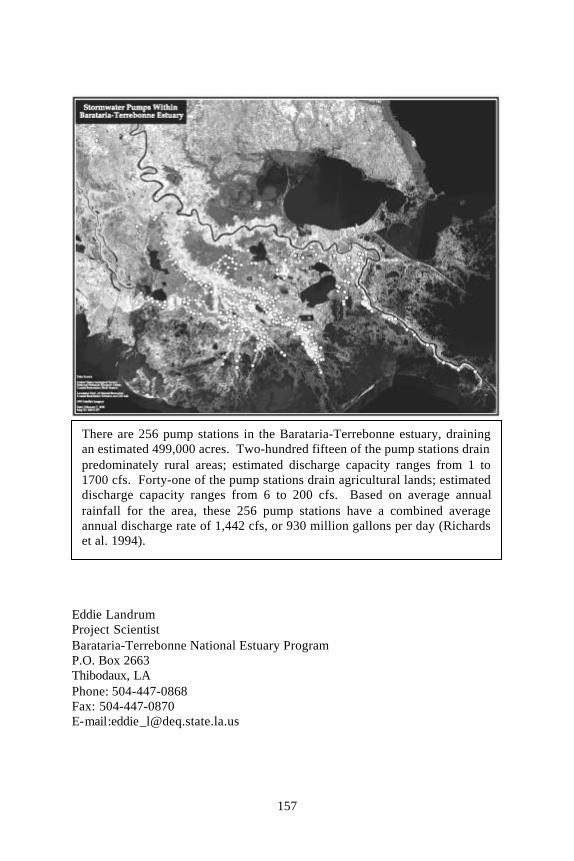
Most populated areas within the Barataria-Terrebonne estuary are protectedagainst hurricane surges by levees. Runoff from rural and agricultural areas iscollected in a borrow canal just inside the levee and then pumped into adjacentwetland areas by a series of stormwater pump stations. Over 250 pump stationsin the Barataria-Terrebonne estuary currently discharge stormwater, drainingapproximately 500,000 acres. These pump discharges are generally directedinto large, man-made canals to ensure that stormwater is evacuated from theleveed area as quickly as possible; this stormwater flows directly to high-salinitybays often through some of Louisiana's prime oyster growing waters.Redirecting stormwater discharges so they are retained in adjacent wetlands may(1) help maintain lower local salinities, (2) provide a source of sediments tosubsiding wetland areas, and (3) support plant growth. Such endpoints couldprove beneficial to degrading wetland systems, especially those directly seawardof levees that protect property from storm surges and flooding. Retention of

152
stormwater may also produce corollary water quality benefits, such as nutrientuptake and pathogen die-off prior to the stormwater flowing to oyster growingareas.
This stormwater redirection concept was formally recognized in the Barataria-Terrebonne National Estuary Program's consensus-derived ComprehensiveConservation and Management Plan. Action Plan EM-12, StormwaterManagement, states that the Plan supports a series of stormwatertreatment/wetland enhancement demonstration projects to (1) reduce negativeimpacts of current stormwater disposal practices, (2) reduce loadings ofnutrients and pathogens to waterways, and (3) enhance wetland vegetation withinputs of nutrients, silt, and freshwater (Moore and Rivers, 1996).
There are a variety of strategies for redirecting stormwater discharges toadjacent wetlands. It might only involve blocking off selected canals, causingthe stormwater to overflow the canal banks and move into surrounding wetlands.Rigid structures, such as sheet piling, additional discharge pipe, and diffusionmechanisms may also be needed to properly divert the stormwater. Project costsand potential effects, both positive and negative, must be assessed for eachpotential project. Adverse effects might include some scouring at the dischargesite(s), changes in flora and fauna over time in the affected area, changes incommercial and recreational opportunities in the affected area, and limitingavailability of some navigation channels.
The stormwater redirection concept will be tested at the Pointe au ChienWildlife Management Area in Terrebonne Parish, Louisiana. A comprehensivemonitoring program will attempt to measure the effects of stormwaterredirection to wetlands on vegetation, marsh elevation, water quality, localhydrology, and living resources. Project supporters realize that it is critical tocharacterize these rural and agricultural stormwater discharges, and their effecton wetland ecosystems, due to concerns about adverse impacts of urbanstormwater discharges. In addition, appropriate consideration must be given tonot increasing the threat − or the perceived threat − of local flooding, as floodprotection is of paramount importance to local residents.
A Demonstration Opportunity
Terrebonne Parish Consolidated Government is increasing the elevation of ahurricane protection levee along the south side of the Pointe au Chien ridge.The elevation increase requires a concurrent berm-width increase that willencroach into wetlands within the Pointe au Chien Wildlife Management Area.Terrebonne Parish has negotiated a right-of-way for the berm-width increasefrom the Louisiana Department of Wildlife and Fisheries, but, as mitigation, isrequired to locate a stormwater pump discharge into the affected wetlands. TheParish already owns a piece of property along the south side of the Pointe auChien ridge, with continuous access from the road to the borrow canal and
153
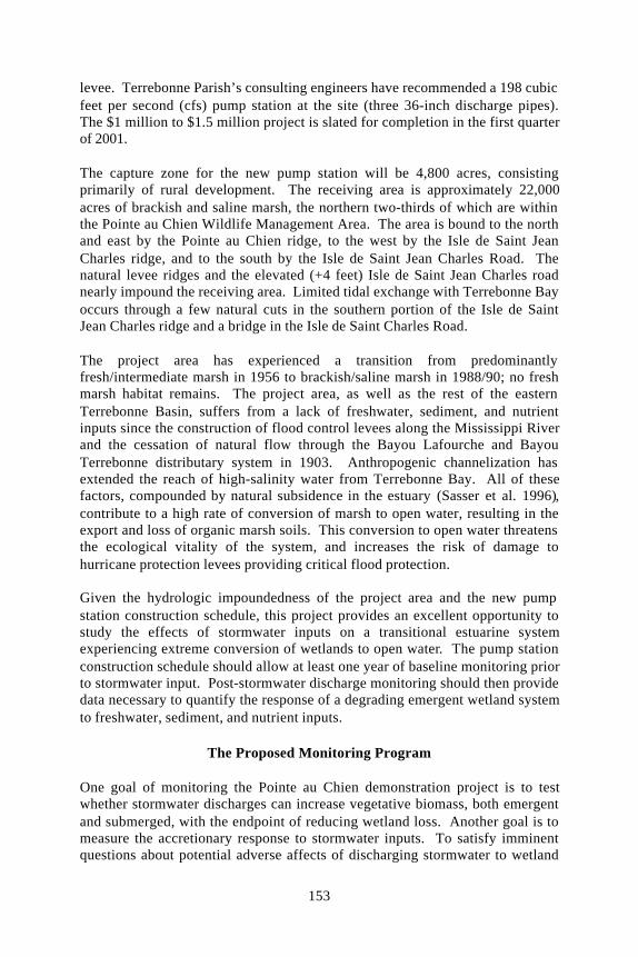
levee. Terrebonne Parish’s consulting engineers have recommended a 198 cubicfeet per second (cfs) pump station at the site (three 36-inch discharge pipes).The $1 million to $1.5 million project is slated for completion in the first quarterof 2001.
The capture zone for the new pump station will be 4,800 acres, consistingprimarily of rural development. The receiving area is approximately 22,000acres of brackish and saline marsh, the northern two-thirds of which are withinthe Pointe au Chien Wildlife Management Area. The area is bound to the northand east by the Pointe au Chien ridge, to the west by the Isle de Saint JeanCharles ridge, and to the south by the Isle de Saint Jean Charles Road. Thenatural levee ridges and the elevated (+4 feet) Isle de Saint Jean Charles roadnearly impound the receiving area. Limited tidal exchange with Terrebonne Bayoccurs through a few natural cuts in the southern portion of the Isle de SaintJean Charles ridge and a bridge in the Isle de Saint Charles Road.
The project area has experienced a transition from predominantlyfresh/intermediate marsh in 1956 to brackish/saline marsh in 1988/90; no freshmarsh habitat remains. The project area, as well as the rest of the easternTerrebonne Basin, suffers from a lack of freshwater, sediment, and nutrientinputs since the construction of flood control levees along the Mississippi Riverand the cessation of natural flow through the Bayou Lafourche and BayouTerrebonne distributary system in 1903. Anthropogenic channelization hasextended the reach of high-salinity water from Terrebonne Bay. All of thesefactors, compounded by natural subsidence in the estuary (Sasser et al. 1996),contribute to a high rate of conversion of marsh to open water, resulting in theexport and loss of organic marsh soils. This conversion to open water threatensthe ecological vitality of the system, and increases the risk of damage tohurricane protection levees providing critical flood protection.
Given the hydrologic impoundedness of the project area and the new pumpstation construction schedule, this project provides an excellent opportunity tostudy the effects of stormwater inputs on a transitional estuarine systemexperiencing extreme conversion of wetlands to open water. The pump stationconstruction schedule should allow at least one year of baseline monitoring priorto stormwater input. Post-stormwater discharge monitoring should then providedata necessary to quantify the response of a degrading emergent wetland systemto freshwater, sediment, and nutrient inputs.
The Proposed Monitoring Program
One goal of monitoring the Pointe au Chien demonstration project is to testwhether stormwater discharges can increase vegetative biomass, both emergentand submerged, with the endpoint of reducing wetland loss. Another goal is tomeasure the accretionary response to stormwater inputs. To satisfy imminentquestions about potential adverse affects of discharging stormwater to wetland
154
systems, the monitoring program will measure the response of water andsediment quality – specifically (1) nitrogen and phosphorus uptake, (2)eutrophication potential, (3) toxics, (4) pathogens, and (5) dissolved oxygen – tostormwater inputs. An additional goal is to measure the response of organismsand biological communities to stormwater inputs. Inherent to monitoring for allother parameters is understanding the effect of stormwater inputs on localhydrology, including the extent of influence and salinity regime. Availablefunding will be used to address as many of the monitoring goals as possible.
Sample sites, including one or more reference/control sites, will be establishedafter conducting hydrologic assessments of the affected area, and selecting thepump station discharge/diffusion mechanism. At least one hydrologicassessment will occur during the highest level of tidal water exchange (e.g.,spring tides or frontal passage). Monitoring sites will include the pump stationinfluent and permanent and mobile transect stations. Sampling intervals will beoptimized for various parameters of concern based on available funding, butstorm-event sampling and continuous monitoring of selected parameters will beincorporated into the monitoring plan.
To monitor the effect of stormwater discharges on wetland vegetation, (1)emergent marshgrass biomass will be measured annually at the end of the seasonpeak (i.e., September); (2) submergent aquatic vegetation biomass will bemeasured at spring and fall peaks; (3) percent coverage of emergent vegetationwill be measured annually at the end of the season peak using the Braun-Blanquet technique; and (4) percent coverage of submerged vegetation will bemeasured at spring and fall peaks using a frequency of occurrence technique.
To monitor the effect of stormwater discharges to wetlands on marsh elevation,vertical accretion will be measured every six months using both feldspar horizonmarker and sediment erosion table techniques.
To monitor the effect of stormwater discharges to wetlands on water quality, thefollowing parameters will be measured monthly (or, when possible,continuously): (1) nitrate nitrogen; (2) ammonium nitrogen; (3) total nitrogen;(4) phosphate; (5) total phosphorous; (6) silicates; (7) iron; (8) total suspendedsolids; (9) chlorides; (10) chlorophyll-a; (11) fecal coliform bacteria; and (12)dissolved oxygen. Priority pollutant and pesticide screenings of the stormwaterpump influent will occur annually, during both a wet and a dry period (thepriority pollutant screening will not include an analysis of volatile organiccompounds). If appreciable levels of contaminants are found in the influentduring the priority pollutant and pesticides screenings, a similar screening oflocal sediment samples will occur.
To monitor the effect of stormwater discharges on local hydrology the followingparameters will be measured monthly (or, when possible, continuously): (1)temperature; (2) pH; (3) specific conductance; and (4) salinity.

155
At this point, funding is not available to support a statistically-valid assessmentof stormwater discharge effects on living resources, especially benthicorganisms. However, a new parking lot and boat ramp will be constructed at theIsle de Saint Jean Charles community, directly adjacent to the impounded studyarea. The Louisiana Department of Wildlife and Fisheries has plans to monitorthe effects of this new access point on fisheries usage. It is possible that thisstudy's monitoring program will correspond with the Pointe au Chienstormwater project.
Building Public Awareness
A public education campaign will be developed for the Pointe au Chiendemonstration project and the stormwater redirection concept, in general.Newspaper articles about the stormwater redirection concept have recentlyappeared in local newspapers. Titles such as “Pumps could help wetlands” and“Use of pumps proposed as conservation tool” have begun the process ofdisseminating information about the concept local constituencies. However, aletter to the Houma Courier editor on February 20, 2000 expressed concernabout potential adverse effects of discharging untreated stormwater to wetlands.The point should be made all future project descriptions that most stormwaterpump stations in the Barataria-Terrebonne estuary already discharge to thewetland ecosystem, and the redirection concept only proposes using theseexisting discharges in a beneficial manner.
References
Day, Jr., J.W., J.M. Rybczyk, L. Cardoch, W. Conner, P. Delgado-Sanchez,R. Pratt, and A. Westphal. In review. Wetland wastewater treatment inLouisiana.
Lane, R.L and J.W. Day, Jr. 1999. Water quality analysis of a freshwaterdiversion at Caernarvon, Louisiana. Estuaries 22(2A): 327-336.
Moore, D.M. and R.D. River, eds. 1996. The Technical Supplement:CCMP Action Plan Details For Plan Implementation, CCMP - Part 3.Barataria-Terrebonne National Estuary Program, Thibodaux, Louisiana.
Richards, P.A., M.G. Waldon, M.R. Ramsey, and M.T. Hebel. 1994.Storm Water Drainage Stations: Location, Mapping, and Recommendations forEvaluation. Prepared by the University of Southwestern Louisiana Center forLouisiana Inland Water Studies for the Barataria-Terrebonne National EstuaryProgram, Thibodaux, Louisiana. September 1994.
Sasser, C.E., M.D. Dozier, J.G. Gosselink, and J.M. Hill. 1986. Spatial andtemporal changes in Louisiana's Barataria Basin marshes, 1945-1980.Environmental Management, 10(5): 671-680.
Turner, R.E. and M.E. Boyer. 1997. Mississippi River diversions, coastalwetland restoration/creation and an economy of scale. Ecological Engineering8: 117-128.

156
These two photos show the potential benefits of redirecting stormwater towetlands. On the left, where stormwater discharges to a large canal,adjacent wetlands appear to be converting to open water. On the right, in anarea otherwise prone to degradation, there appears to be vigorous vegetationgrowth in the vicinity of the stormwater discharge.
157
Eddie LandrumProject ScientistBarataria-Terrebonne National Estuary ProgramP.O. Box 2663Thibodaux, LAPhone: 504-447-0868Fax: 504-447-0870E-mail:[email protected]
There are 256 pump stations in the Barataria-Terrebonne estuary, drainingan estimated 499,000 acres. Two-hundred fifteen of the pump stations drainpredominately rural areas; estimated discharge capacity ranges from 1 to1700 cfs. Forty-one of the pump stations drain agricultural lands; estimateddischarge capacity ranges from 6 to 200 cfs. Based on average annualrainfall for the area, these 256 pump stations have a combined averageannual discharge rate of 1,442 cfs, or 930 million gallons per day (Richardset al. 1994).