th1.l09 - algae: a fast algebraic estimation of interferogram phase offsets in space varying...
TRANSCRIPT

Stefano Tebaldini, Guido Gatti, Mauro Mariotti d’Alessandro, and Fabio Rocca
Politecnico di Milano
Dipartimento di Elettronica e Informazione
ALGAE: A FAST ALGEBRAIC ESTIMATION OF
INTERFEROGRAM PHASE OFFSETS IN
SPACE VARYING GEOMETRIES
IGARSS 2010, Honolulu

ALGebraic Altitude Estimation
ALGAE is an algebraic procedure for the geometrical interpretation of
interferometric measurements from a multi-baseline SAR system
Features:
• Joint estimation of terrain topography and phase offsets
• Handles the case where the normal baselines undergo a large
variation along the imaged swath
• Compatible with different kinds of a-priori information to carry out
absolute phase calibration
• Fast
• Robust

Problem Statement
SAR Interferometry has repeatedly been shown to constitute a major tool for the retrieval of terrain topography at vast scales
• SAR imaging provide information about the target to sensor distance
Information from multiple (≥2) images can be merged to locate the target in 3D
• Interferometric phase differences provide high accuracy measurements, being sensitive to wavelength scale variations of the target to sensor distance
Reference
Track
Track n
Track N
ground range
elev
atio
n
azimuth
r
rn
rN
Pulse Envelope
Wavelength
P
m
P
n
P
nm rr
4
P
θ

Problem Statement
Reference
Track
Track n
Track N
ground range
elev
atio
n
azimuth
rn +drn
rN+drN
Pulse Envelope
Wavelength
SAR Interferometry has repeatedly been shown to constitute a major tool for the retrieval of terrain topography at vast scales
• SAR imaging provide information about the target to sensor distance
Information from multiple (≥2) images can be merged to locate the target in 3D
• Interferometric phase differences provide high accuracy measurements, being sensitive to wavelength scale variations of the target to sensor distance
P
m
P
n
P
m
P
n
P
nm drdrrr
4
• Though, distance measurements are affected by Propagation Disturbances (PDs), arising from uncompensated delay of the Radar echoes
o Propagation through the atmosphere
o Residual platform motion
• PDs make the retrieval of absolute topography nearly an ill-posed problem in absence of a-priori informationP
r + dr
θ

Problem Statement
• Problem sensitivity is easily discussed considering phase variation w.r.t. target height:
Track nTrack m
ground range
elev
atio
n
azimuth
rθ
PΔzP
Δθ
• For a typical InSAR configuration Δθ = 1/1000 – 1/100
=> error amplification is huge
P
nmnm
P Kzz 1PnmP
nm
P
nm zzKz
sin
4
P
nm
P
zdre
sin
• Height error due to PDs is readily obtained as:
drP = Total propagation error at point P
Kznm = Height to phase conversion factor for tracks n and m

Problem Statement
Track nTrack m
ground range
elev
atio
n
azimuth
rθ
PΔzP
Δθ
• For a typical InSAR configuration Δθ = 1/1000 – 1/100
=> error amplification is huge
RΔzR
RP
nm
R
nm
P
nm zzKz P
z
RP
nm
R
z
P
z edrdree
sin
• However, PDs typically exhibit a large decorrelation length w.r.t. to the SAR resolution cell
o Atmospheric delay is uniform within about 1 km
o The dynamics of platform deviations from nominal trajectory is slow w.r.t. to platform velocity
This information allows accurate topography retrieval w.r.t. to a reference point
• Problem sensitivity is easily discussed considering phase variation w.r.t. target height:
• For a typical InSAR configuration Δθ = 1/1000 – 1/100
=> error amplification is huge
PnmP
nm
P
nm zzKz
sin
4
Kznm = Height to phase conversion factor for tracks n and m
• Height error due to PDs is readily obtained as:
drP = Total propagation error at point P
P
nmnm
P Kzz 1
P
nm
P
zdre
sin

Problem Statement
• Still, the problem changes when the spatial variation of the height to phase conversion factors is relevant. In this case:
RR
nm
P
nm
RPP
nm
RR
nm
PP
nm
R
nm
P
nm
zKzKzzzKz
zKzzKz
Track n
Track m
ground range
elev
atio
n
azimuth
rθ
PΔzP
Δθ
RΔzR
• A new term arises, that depends on
o The spatial variation of Kz
o The true height of the reference point w.r.t. the reference ground plane
• Impact on height estimation:
R
zP
nm
R
nmR
z
P
z eKz
Kzee
1
Handling space varying geometries require precise external information about the sensor to target distances for the reference point
• Even if PDs are perfectly compensated for by the phase locking operation, the error about the reference point height results in a space variant error propagating throughout the scene
o Particularly relevant for airborne geometries, where Kz can undergo a variation by a factor 3
Space Variant Error

The problem can be cast in general terms as:
An Algebraic Interpretation
P
n
PP
n
P
nzKz
Unwrapped Interferometric phase at point P in track n Height to phase
conversion factor at point P in track n
Target height at point P w.r.t. the reference
topography
PD at point Pin track n
Stacking all phase measurements we get:Topography
[NP × 1]
Forward Operator
[N∙NP × (Nα+ NP)]
Data
[N∙NP × 1]
zGmG
Parameters describing PDs in all tracks
[Nα × 1]
This problem admits the general solution:
cNGz
G
Pseudo-Inverse of G Null Space
of G
Set of arbitrary constants
The null space determines the ambiguity of the problem
o Data fit is invariant w.r.t. to the choice of c
The constants c represent the degrees of freedom of the problem, providing the proper access point to plug external information into the solution
Forward Problem
Inverse Problem

An Algebraic Interpretation
Remarks:
• Linearization about a reference topography does not entail any loss of generality, the eventual ambiguity or ill-conditioning of the inversion being intrinsic to the nature of the problem
• Linearization error can be recovered through iterative inversion methods (Newton-Raphson)
z
GmGRemarks (II):
• How many parameters for the PDs?
• Correct choice depends on
o Extent of the imaged scene
o Physics of PDs (i.e.: atmosphere, dynamics of platform motion…)
o Precision of motion compensation procedures previously applied
• In this work we assume a constant phase offset in each track
The assumption is simplistic, yet:
o Valid on limited areas
o Allows the discussion of the effects of space varying geometries
n
P
n NN

An Algebraic Interpretation
For the case of constant phase offsets it may be shown that:
• The forward operator allows a 1D null space if and only if the height to phase conversion factors undergo the same spatial variation in all tracks, i.e.:
:.., tsKk P
n
P
n
P
nKkKz
• If C1 is fulfilled, the general solution for terrain topography is given by:
(C1)
P
Nullspace
P
Inversion
P zczz 1
PP
NullspaceKz
We distinguish three cases:
Spaceborne InSAR Airborne InSAR - Ideal
Kz can be considered constant if the swath is not too large
1
P
nn
K
Kzk
czz P
Inversion
P
=> Terrain topography is retrieved up to a constant
=> C1 is fulfilled with:
Assuming parallel trajectories C1 is fulfilled with
PPPP
nn
rKK
bbk
sin,
/1
1
PP
Inversion
P Kczz
=> Terrain topography is retrieved up to a space varying –topography dependent – term
Airborne InSAR – Real
C1 is not fulfilled
=> The problem is well posed
=> Retrieval of absolute terrain topography is theoretically possible

ALGebraic Altitude Estimation
Absence of the null space is only apparently an
advantage
• The problem is extremely ill-conditioned, the last
Singular Value being very close to zero
• Consistent with the arising of a 1D null space in nominal
conditions
ALGAE
• The forward operator is modified by zeroing the last Singular Value (Truncated SVD)
Ill-conditioning problems are solved, at the expense of the arising of a 1D null space
• The value of c is then determined according to the available a-priori information
o Point match with an accurately measured reference point
o Best global match with coarse reference DEM
o Zeroing mean slope
o Other….
Spaceborne
Airborne - Real
Sin
gu
lar
Val
ues
Sin
gu
lar
Val
ues
Sin
gu
lar
Val
ues
0
0
0.002
Airborne - Ideal
P
Nullspace
P
Inversion
P zczz
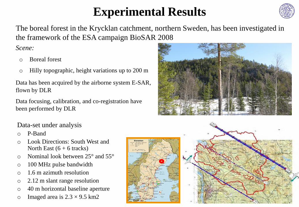
The boreal forest in the Krycklan catchment, northern Sweden, has been investigated in
the framework of the ESA campaign BioSAR 2008
Scene:
o Boreal forest
o Hilly topographic, height variations up to 200 m
Data has been acquired by the airborne system E-SAR,
flown by DLR
Data focusing, calibration, and co-registration have
been performed by DLR
Experimental Results
Data-set under analysis
o P-Band
o Look Directions: South West and North East (6 + 6 tracks)
o Nominal look between 25° and 55°
o 100 MHz pulse bandwidth
o 1.6 m azimuth resolution
o 2.12 m slant range resolution
o 40 m horizontal baseline aperture
o Imaged area is 2.3 × 9.5 km2

Unwrapped
interferometric
ground phases
Multi-Baseline,
Multi-Polarimetric
Data
Algebraic
Synthesis
Ground-only
Contributions
Phase
Linking
Algorithm
Best Estimate of the
Ground Phases
with respect to a
Common Master
2-Dimensional
Phase
Unwrapping
Pre-ProcessingPre-Processing Operations
• The Algebraic Synthesis technique is used to extract contributions from ground-only scattering,
thus avoiding being affected by vegetation bias
• The retrieved ground-only contributions are processed with the Phase Linking algorithm to
estimate the ground phases with respect to a common Master
• Ground phases are unwrapped, and used as input for ALGAE
ALGAE
Algebraic Synthesis:
“Algebraic Synthesis of Forest Scenarios from Multi-
baseline PolInSAR data” –Tebaldini – TGARS vol 47, no 12,
Dec.2009
Phase Linking:
“On the Exploitation of Target Statistics for SAR
Interferometry Applications” – Monti Guarnieri and Tebaldini –
TGARS vol 46, no 11, Nov.2008

ynwi Track n
Polarization wi
Re{yn(w1)} Re{yn(w2)} Re{yn(w3)}
Im{yn(w1)} Im{yn(w2)} Im{yn(w3)}
Track 1 HH HV
VH VV
HH HV
VH VV
Track n
Track N
HH HV
VH VV
Algebraic
Synthesis
Volume Contributions
Ground Contributions Ground
200 600 1000 1400 1800 2200-10
0102030405060
200 600 1000 1400 1800 2200-10
0102030405060
Algebraic SynthesisAlgebraic Synthesis (AS) technique for the decomposition of Ground and Volume
scattering basing on multi-polarimetric and multi-baseline SAR surveys
Further details in: POLARIMETRIC AND
STRUCTURAL PROPERTIES OF FOREST
SCENARIOS AS IMAGED BY LONGER
WAVELENGTH SARS
Poster Session: THP2.PA.3 - Radar Mapping
Thursday, July 29, 14:55 - 16:00

Retrieving the set of the ground interferometric coherences does not solve the problem of retrieving the ground phases, since ground scattering can be affected by decorrelationphenomena such as:
ground rangeel
evat
ion
Reference
Track
Track n
Track N
rref
rn
rN
• Thermal noise• Superficial decorrelation • Temporal decorrelation
rn : distance to the n-th SAR sensor
αn : Propagation Disturbance in the n-th acquisition
This problem is solved by the Phase Linking algorithm
• Multi-baseline Maximum Likelihood estimation of the phases associated with the optical path lengths from a target to the N SAR sensors, accounting for target decorrelation phenomena
Interferogram phases:
Linked phases:
n yref yn 4
rref rn ref n
n 4
rref rn ref n
+ Phase Noise
Minimum Variance Phase Noise given N tracks
+
Phase Linking

150
200
250
300
350
Ground Coherence
0.5
0.75
1
Ground Coherence
-10
0
10
Ground Range Slope Ground Range SlopeLIDAR DEM
Preliminary Analysis
• Ground coherence is extremely
high
excellent ground visibility
excellent temporal stability
• A slight trend w.r.t. the incidence
angle can be (correctly!)
appreciated in both directions
• The spatial variation of ground
coherence is clearly correlated
with terrain slope, regardless of
heading direction

Track 1 Track 2 (Master)
Track 3 Track 4
Track 5 Track 6
azimuth azimuth
slan
t ra
nge
slan
t ra
nge
slan
t ra
nge
Preliminary Analysis
Height to Phase Conversion Factors
• South-West Data-set
• Large range variation
range and look angle
variation within the imaged
swath
• Large azimuth variation
Platform motion

Track 1 Track 2 (Master)
Track 3 Track 4
Track 5 Track 6
azimuth azimuth
slan
t ra
nge
slan
t ra
nge
slan
t ra
nge
Ground Phases
• South-West Data-set
• LIDAR DEM removed
• Fringes are high quality,
consistently with the
observed high ground
coherence
• Fringes are correlated
with the Kz
non-perfect
compensation of platform
deviation from nominal
trajectories
Preliminary Analysis

ALGAE - Results
Look Direction
Least Square Solution Null Space
South West data-set

Null Space - High Pass Component ALGAE Solution
ALGAE - ResultsSouth West data-set
• Null space = along range trend + azimuth oscillations
• The null space is added so as to zero the mean range slope
• Along-range errors recovered
• Along-azimuth errors partly recovered

Look Direction
ALGAE - Results
Least Square Solution Null Space
South West data-set
• Same reference point as in the SW data-set brings
to a large trend in the LS solution

ALGAE - Results
Null Space - High Pass Component ALGAE Solution
South West data-set
• Null space = along range trend + azimuth oscillations
• The null space is added so as to zero the mean range slope
• Along-range errors recovered
• Along-azimuth errors partly recovered
Conclusions
Space varying geometries result in space variant topographic errors that can not be fixed by
evaluating terrain topography w.r.t. one reference point
ALGAE defines an algebraic framework where space variance and propagation disturbances are
explicitly accounted for
o Propagation disturbances represented as constant phase offsets and estimated along with topography
o The degree of freedom provided by the concept of null space is compatible with different kinds of
a-priori information, either local or global
o Fast
o Robust
Residual DEM errors:
o characterized by a large spatial decorrelation length
o correlated with the flight direction
=> Presence of residual phase terms due to residual platform motion Insufficiency of the constant
phase offset model
Future researches:
• Incorporate more sophisticated models to describe propagation disturbances, taking into account
both the physics of atmospheric propagation and platform motion