th march 2014 graph inc stormier than “essence” …
TRANSCRIPT

The Long Range Forecasters
2014 March 30d ahead Forecast Britain & Ireland graph inc Produced under Solar Lunar Action Technique SLAT 9B – Summary - Detailed weather periods - Maps – Graphs
Including Solar-based likely corrections to apply to Short-range Standard Meteorology Forecasts Weather Action are the only long range forecasters with independently proven published skill. See www.weatheraction.com WeatherActionTV - latest Vids on weather and the struggle against theCO2 warmist delusion - http://www.youtube.com/user/WeatherActionTV
For Short Range localised forecasts - Weathernet (independent of WeatherAction) personal premium rate service on 09061100445
Confidential 2014 March 30d (8 weather periods) Brit & Ire SLAT (Solar-Lunar-Action-Technique) 9B forecast. Prod 26 February, released 1st March. Same as 45d prod. 18th Feb, apart from typos and very small changes.
© Weather Action Tel +44(0)20 7939 9946
MARCH 2014 graph inc Headline & essential development. WETTER & STORMIER THAN “ESSENCE” FORECAST (9/9/13)
“In like a Lion, out like a Lamb” - Wet & stormy for most of month; spectacular relief - fine warm summery weather for most of Britain & Ireland in last week. • Widespread Flooding continues • More damage to sea defences 4 stormy spells. Ireland & W/SW Britain take further poundings from winds flood-
rains, and giant sea waves and tides in first 3 weeks. Last storm mainly Scotland. Most unsettled storm periods N Atlantic / Britain, Ireland & N Europe +/-1d
Mar ~1-5 (R4{1-2} then R3), ~10-12th (R5), ~14-15 (R5), ~23-24 (R5) mainly Scotland.
One of the stormiest 3 week periods of March since the last M-I-A ~200 years ago Wild Jet stream / Mini-Ice-Age circulation and events in N Hem continue and
become more extreme under phase 2 (“Rapid Intensification”) of the New mini ice-age in WeatherAction Solar Lunar Action Technique, SLAT9b (Phase 1 was preliminary developments over last few years. SLAT9b applies in phase 2)
Map details in 8 weather periods p 2-4. Graph and overalls p 5-6 Weather warnings and corrections to short range standard meteorology Standard short range meteorology TV forecasts will underestimate rain, snow, thunder/tornado risk, cyclogenesis risk and wind levels in WeatherAction Solar-Lunar-Action-Technique (SLAT) R5 & R4 ‘Top Red’ extra activity periods. In/around those periods the standard Met forecasts from 12/24hrs ahead of precipitation need to be typically ~doubled (or ~more for R5). These factors and modifications which improve on TV forecasts are independent of details of pressure patterns, verified or not, for these times. Forecast users are welcome to warn others.
Hurricane winds confirm Feb WeatherAction ‘wild-winter’ forecast Revision
• “Rapid intensification” of new mini ice age Wild Jet Stream extremes is here. • CO2 warmist ‘science’ in total disarray “Dramatic Hurricane Force 12 winds in Wales on 12 Feb superbly confirmed our WeatherAction warning that our already forecast (4 wks ahead) top winds Force 10/11 Feb10-12 would notch up to Force 11/12 and the whole pressure pattern would shift ~250 miles SE. We warned that 6d ahead but it was only ~12 hours ahead that standard Met saw it coming. This intensification of extreme events means the world is now past the preliminary phase of this new Mini Ice Age”, says Piers Corbyn, Astrophysicist of WeatherAction. Cont over. This news story is public
© Weather Action™& Piers Corbyn™ © accept no liability for any loss howsoever arising from use of forecast information. Application of forecasts is entirely at the user’s risk. None of this forecast may be published or circulated in media or on web or used in production of other forecasts without agreement.

2014 March 30d (8 weather periods) Brit & Ire SLAT (Solar-Lunar-Action-Technique) 9B forecast. Prod 26
February, released 1st March. Same as 45d prod. 18th Feb, apart from typos and very small changes. Confidential. © Weather Action
Tel +44(0)20 7939 9946 Time periods normally accurate to +/- one day. At least 6 of the 8 should be basically correct this month.
Key Solar Lunar Action Periods Solar factors statement and improvements to be made to short-range forecasts when they come on TV are the most confident. Details are generally less certain. = Traffic Light warning / descriptions for Weather periods. For warning notes and explanation see page 6
1-5 March 2014 AB = 80% 6-9 March 2014 BC = 80% Stormy, wet and windy, less wet later. Damaging gales & heavy rain in Ireland, Scotland & N/W England & Wales. Flooding continues in Ireland & West/SW Britain. New Moon Mar 1 increases coastal flood risk. Same as 45d.
Heavy rain passes to East, showers persist in Scotland & N/E as S/W turns brighter and fine in parts. Prob dry everywhere later. Same as 45d.
Winds: W/SW Force 10/11 In west, espec coasts; less windy SE and East.
Winds: W’ly strong (7/8 in N) at first, bec lighter later.
Temps: Mild/very mild. Temps: Normal/ coolish (by day)
Sky: Cloudy, brighter from west later (4-5). Sky: Becoming brighter espec Ire + SW ; variable in N/E. Solar Factor: R4 1-2nd ; R3 3-5th Solar Factors: R3 6-7th; NSF/Q 8-9th
Public News story continued from page 1
Intensified MIA Extremes “We have now advanced *SLAT9A to 9B (*Solar Lunar Action Technique) to get these new, ‘rapid MIA intensification’, extremes and are very pleased that we seized the right time to make the change which we knew had to come but were not sure when. The Slat 9A/B change to frontal impacts of the next R5 23-25th was also confirmed by greater penetration of weather fronts and substantially enhanced winds compared to Met Office Short Range forecasts. “We are steering with our unique SLAT ‘mathematical map’ through a maze of amazing dramatic sun-earth-weather relations that have not been like this for over 200years, yet we are getting it right!”
THERE IS MUCH WORSE TO COME “Specific extreme solar active events, brilliant auroras, ‘Sudden’ Stratospheric Warmings and increasingly wild jet stream behaviour in the last two months including the relentless pounding of Britain and Ireland at the same time as USA was and is gripped in the offset polar vortex freeze-up all confirm our specific and general forecast of an advancing new Mini-Ice-Age. Yet these are but a taste of wild extremes to come. “Now we have moved from ‘Preliminary MIA (phase1) to Rapid Intensification (phase 2) very wild extremes – including heat but more often cold – will increase. Extremes very like recently – and worse - struck across the world in the last MIA – Dalton minimum. James A Marusek’s excellent historical scary record shows what will hit in coming months and years:- http://ktwop.files.wordpress.com/2010/12/weather-chronology-dalton.pdf “The CO2 warmists whose forecasts have failed and failed again are in total disarray in terms of their ‘science’ but rather than admit it they have chosen to lie and lie again; escalate troll attacks against WeatherAction and steal and re-package our mini-ice-age related information, prognoses, warnings and forecasts and present them as if they were due to their delusional CO2 anti-science even though their own models predict opposite extremes and show CO2 cannot cause the wild Jet Stream. They’re disgraceful charlatans who must be relentlessly exposed and drummed out of their parasitic green posts and funds which are theft from the taxpayer.
See http://www.weatheraction.com/docs/WANews14No06.pdf
Likely possible weather map scenario: Deep low attacks Ireland and Britain with fronts crossing into France and low countries. Centre of low tracks North of Scotland to (later) North/Central Scandinavia. Partial blocking high pressure East Scandinavia, France & Central Europe. Azores High somewhat south extending to Iberia. Active low Siberia & West Russia. Jet Stream: Normal.
Likely possible weather map scenario: Low pressure centres on South Scandinavia with higher pressure developing N/Central Scandinavia. Mostly low pressure Europe. Azores High extended to South Iberia. Pressure mostly high in Med & Black Sea. Jet Stream: Blocked in Atlantic.
Weather Action™ © & Piers Corbyn accept no liability for any loss howsoever arising from use of forecast information. Application of forecasts is entirely at the user’s risk. None of this forecast may be published or circulated in media or web or used in production of other forecasts without agreement of Weather Action & Piers Corbyn. Media use is welcome but may only be from issued quotes to the media concerned or displays on www.weatheraction.com
Ch Isles Ch Isles
Showers fade, becoming dry &
bright.
Showers at first – less later. Cloudy then variable sky later.
Dry/mostly dry. Cloud clears
becoming mostly fine & warm.
Wet & windy, floods continue
Stormy /gales. Force 10/11 on coasts, torrential rain, thunder, hail + flooding. Less wet later. Coastal damage.
Wet & windy, flash floods in
parts.
Very heavy seas, lull later
Very heavy seas, lull later
heavy seas, lull
later Mod-heavy seas mod later
2014 March 30d (8 weather periods) Brit & Ire SLAT (Solar-Lunar-Action-Technique) 9B forecast. Prod 26
February, released 1st March. Same as 45d prod. 18th Feb, apart from typos and very small changes. Confidential. © Weather Action
Tel +44(0)20 7939 9946 Time periods normally accurate to +/- one day. At least 6 of the 8 should be basically correct this month.
Key Solar Lunar Action Periods Solar factors statement and improvements to be made to short-range forecasts when they come on TV are the most confident. Details are generally less certain. = Traffic Light warning / descriptions for Weather periods. For warning notes and explanation see page 6
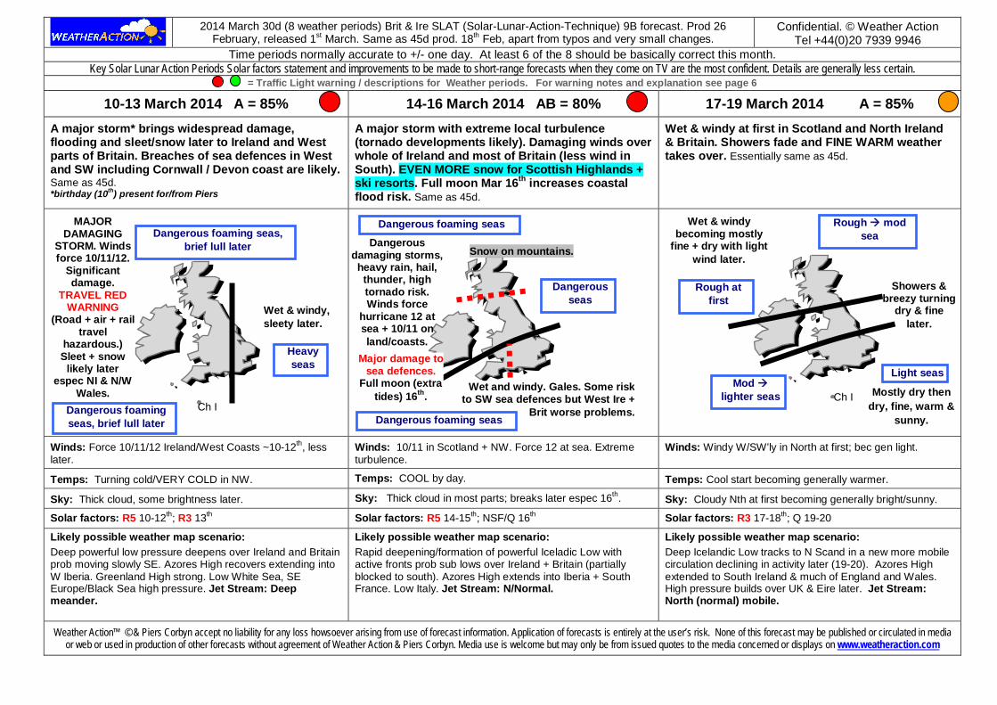
10-13 March 2014 A = 85% 14-16 March 2014 AB = 80% 17-19 March 2014 A = 85% A major storm* brings widespread damage, flooding and sleet/snow later to Ireland and West parts of Britain. Breaches of sea defences in West and SW including Cornwall / Devon coast are likely. Same as 45d. *birthday (10th) present for/from Piers
A major storm with extreme local turbulence (tornado developments likely). Damaging winds over whole of Ireland and most of Britain (less wind in South). EVEN MORE snow for Scottish Highlands + ski resorts. Full moon Mar 16th increases coastal flood risk. Same as 45d.
Wet & windy at first in Scotland and North Ireland & Britain. Showers fade and FINE WARM weather takes over. Essentially same as 45d.
Winds: Force 10/11/12 Ireland/West Coasts ~10-12th, less later.
Winds: 10/11 in Scotland + NW. Force 12 at sea. Extreme turbulence.
Winds: Windy W/SW’ly in North at first; bec gen light.
Temps: Turning cold/VERY COLD in NW. Temps: COOL by day. Temps: Cool start becoming generally warmer.
Sky: Thick cloud, some brightness later. Sky: Thick cloud in most parts; breaks later espec 16th. Sky: Cloudy Nth at first becoming generally bright/sunny.
Solar factors: R5 10-12th; R3 13th Solar factors: R5 14-15th; NSF/Q 16th Solar factors: R3 17-18th; Q 19-20
Likely possible weather map scenario: Deep powerful low pressure deepens over Ireland and Britain prob moving slowly SE. Azores High recovers extending into W Iberia. Greenland High strong. Low White Sea, SE Europe/Black Sea high pressure. Jet Stream: Deep meander.
Likely possible weather map scenario: Rapid deepening/formation of powerful Iceladic Low with active fronts prob sub lows over Ireland + Britain (partially blocked to south). Azores High extends into Iberia + South France. Low Italy. Jet Stream: N/Normal.
Likely possible weather map scenario: Deep Icelandic Low tracks to N Scand in a new more mobile circulation declining in activity later (19-20). Azores High extended to South Ireland & much of England and Wales. High pressure builds over UK & Eire later. Jet Stream: North (normal) mobile.
Weather Action™ © & Piers Corbyn accept no liability for any loss howsoever arising from use of forecast information. Application of forecasts is entirely at the user’s risk. None of this forecast may be published or circulated in media or web or used in production of other forecasts without agreement of Weather Action & Piers Corbyn. Media use is welcome but may only be from issued quotes to the media concerned or displays on www.weatheraction.com
Ch I Ch I
Ch I
Wet & windy, sleety later.
MAJOR DAMAGING
STORM. Winds force 10/11/12.
Significant damage.
TRAVEL RED WARNING
(Road + air + rail travel
hazardous.) Sleet + snow
likely later espec NI & N/W
Wales.
Dangerous damaging storms, heavy rain, hail, thunder, high tornado risk. Winds force
hurricane 12 at sea + 10/11 on land/coasts.
Mostly dry then dry, fine, warm &
sunny.
Wet & windy becoming mostly
fine + dry with light wind later.
Showers & breezy turning
dry & fine later.
Major damage to sea defences.
Full moon (extra tides) 16th.
Mod lighter seas
Light seas
Rough mod sea
Snow on mountains.
Rough at first
Wet and windy. Gales. Some risk to SW sea defences but West Ire +
Brit worse problems.
Dangerous foaming seas
Dangerous foaming seas
Dangerous seas
Dangerous foaming seas, brief lull later
Heavy seas
Dangerous foaming seas, brief lull later
2014 March 30d (8 weather periods) Brit & Ire SLAT (Solar-Lunar-Action-Technique) 9B forecast. Prod 26 February,
released 1st March. Same as 45d prod. 18th Feb, apart from typos and very small changes. Confidential. © Weather Action
Tel +44(0)20 7939 9946 Time periods normally accurate to +/- one day. At least 6 of the 8 should be basically correct this month.
Key Solar Lunar Action Periods Solar factors statement and improvements to be made to short-range forecasts when they come on TV are the most confident. Details are generally less certain. = Traffic Light warning / descriptions for Weather periods. For warning notes and explanation see page 6
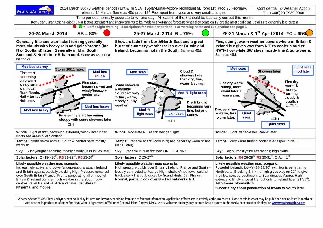
20-24 March 2014 AB = 80% 25-27 March 2014 B = 75% 28-31 March & 1st April 2014 *C = 65% Generally fine and warm start turning generally more cloudy with heavy rain and gales/storms (far N of Scotland) later. Generally mild in South; Scotland & North Ire + Britain cool. Same as 45d but a bit cooler.
Showers fade from North/North-East and a great burst of summery weather takes over Britain and Ireland; becoming hot in the South. Same as 45d.
Fine, sunny, warm weather covers whole of Britain & Ireland but gives way from N/E to cooler cloudier NW’ly flow while SW stays mostly fine & quite warm. Same as 45d.
Winds: Light at first; becoming extremely windy later in far North/sea areas N of Scotland.
Winds: Moderate NE at first bec gen light. Winds: Light, variable bec W/NW later.
Temps: North below normal, South & central parts mostly warmish.
Temps: Variable at first (cool in N) bec generally warm or hot (in SE later)
Temps: Very warm turning cooler later espec in N/E.
Sky: Sunny/bright becoming mostly cloudy (less in Sth later) Sky: Variable in N at first bec FINE + SUNNY. Sky: Bright, mostly fine afternoons; high cloud.
Solar factors: Q (19-) 20th; R3 21-22nd; R5 23-24th Solar factors: Q 25-27th Solar factors: R4 28-29th; R3 30-31st; Q April 1st
Likely possible weather map scenario: Increasingly active and powerful depressions attack Ireland and Britain against partially blocking High Pressure centered over South Britain/France. Fronts penetrating all or most of Britain & Ireland but are much weaker in the South. Low centres travel Iceland N Scandinavia. Jet Stream: N/normal and mobile.
Likely possible weather map scenario: High pressure builds over Britain , Ireland, France and Spain – loosely connected to Azores High; shallow/mod lows Iceland track slowly NE but blocked by Scand High. Jet Stream: Normal, partial block over B + I + continental EU.
Likely possible weather map scenario: Powerful Icelandic Low(s) 28-29/30th with fronts penetrating North parts. Blocking Brit + Ire high gives way on 31st to give mod low centred south/central Scandinavia. Azores High extends to Brit/France at first but only to Ireland later (31st/1st). Jet Stream: Normal/Nth. *Uncertainty about penetration of fronts to South later.
Weather Action™ © & Piers Corbyn accept no liability for any loss howsoever arising from use of forecast information. Application of forecasts is entirely at the user’s risk. None of this forecast may be published or circulated in media or web or used in production of other forecasts without agreement of Weather Action & Piers Corbyn. Media use is welcome but may only be from issued quotes to the media concerned or displays on www.weatheraction.com
Ch I Ch I Ch I
Fine start becoming very wet + windy later with local flash floods. Hail + tornado risk later.
Fine start becoming wet and windy/breezy + cooler later
Some showers & variable cloud give way to fine, warm, mostly sunny weather.
Dry, very fine & warm, less warm later.
Fine dry warm sunny, more cloud later + less warm.
Cloud & showers fade then dry, fine, warm & sunny.
Fine sunny start becoming cloudy with some showers later
Fine dry warm & sunny, turning
cloudy & coolish 31st/1st.
Dry & bright becoming very fine, hot and sunny. Light sea
Mod seas Light seas, mod later
Mod light seas
Mod light seas
Storm 10/11 later. Showers later. Mod seas
Quiet seas
Quiet seas
Mod bec stormy
Mod bec heavy
Mod bec rough
Mod bec heavy
2014 March 30d (8 weather periods) Brit & Ire SLAT (Solar-Lunar-Action-Technique) 9B forecast. Prod 26 February,
released 1st March. Same as 45d prod. 18th Feb, apart from typos and very small changes. Confidential. © Weather Action
Tel +44(0)20 7939 9946
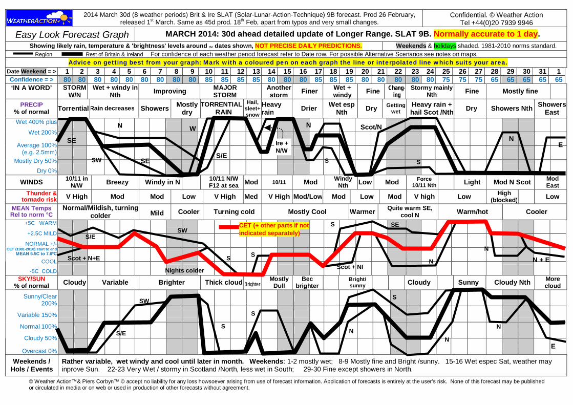
Easy Look Forecast Graph MARCH 2014: 30d ahead detailed update of Longer Range. SLAT 9B. Normally accurate to 1 day. Showing likely rain, temperature & 'brightness' levels around the dates shown, NOT PRECISE DAILY PREDICTIONS. Weekends & holidays shaded. 1981-2010 norms standard.
Region Rest of Britain & Ireland For confidence of each weather period forecast refer to Date row. For possible Alternative Scenarios see notes on maps. Advice on getting best from your graph: Mark with a coloured pen on each graph the line or interpolated line which suits your area.
Date Weekend = > 1 2 3 4 5 6 7 8 9 10 11 12 13 14 15 16 17 18 19 20 21 22 23 24 25 26 27 28 29 30 31 1 Confidence = > 80 80 80 80 80 80 80 80 80 85 85 85 85 80 80 80 85 85 85 80 80 80 80 80 75 75 75 65 65 65 65 65 ‘IN A WORD’
STORM
W/N Wet + windy in
Nth Improving MAJOR STORM Another
storm Finer Wet + windy Fine Chang-
ing Stormy mainly
Nth Fine Mostly fine
PRECIP % of normal Torrential Rain decreases Showers Mostly
dry TORRENTIAL
RAIN
Hail, sleet+ snow
Heavy rain Drier Wet esp
Nth Dry Getting wet
Heavy rain + hail Scot /Nth Dry Showers Nth Showers
East
Wet 400% plus
Wet 200%
Average 100% (e.g. 2.5mm)
Mostly Dry 50%
Dry 0%
WINDS 10/11 in N/W Breezy Windy in N 10/11 N/W
F12 at sea Mod 10/11 Mod Windy Nth Low Mod Force
10/11 Nth Light Mod N Scot Mod East
Thunder & tornado risk V High Mod Mod Low V High Med V High Mod/Low Mod Low Mod V high Low High
(blocked) Low MEAN Temps Rel to norm °C
Normal/Mildish, turning colder Mild Cooler Turning cold Mostly Cool Warmer Quite warm SE,
cool N Warm/hot Cooler
+5C WARM
+2.5C MILD
NORMAL +/- CET (1981-2010) start to end
MEAN 5.5C to 7.6ºC COOL
-5C COLD SKY/SUN
% of normal Cloudy Variable Brighter Thick cloud Brighter Mostly
Dull Bec
brighter Bright/ sunny Cloudy Sunny Cloudy Nth More
cloud
Sunny/Clear 200%
Variable 150%
Normal 100%
Cloudy 50%
Overcast 0%
Weekends / Hols / Events
Rather variable, wet windy and cool until later in month. Weekends: 1-2 mostly wet; 8-9 Mostly fine and Bright /sunny. 15-16 Wet espec Sat, weather may inprove Sun. 22-23 Very Wet / stormy in Scotland /North, less wet in South; 29-30 Fine except showers in North.
© Weather Action™& Piers Corbyn™ © accept no liability for any loss howsoever arising from use of forecast information. Application of forecasts is entirely at the user’s risk. None of this forecast may be published or circulated in media or on web or used in production of other forecasts without agreement.
SE
CET (+ other parts if not indicated separately)
S/E
N
SE
S Nights colder Scot + NI
N
S/E SE
S Scot + N+E
S S
N
S/E
SW
SW
N
W
S
SW
Scot/N
S
S
N
N E
N N + E
S
N
E
Ire + N/W

2014 March 30d (8 weather periods) Brit & Ire SLAT (Solar-Lunar-Action-Technique) 9B forecast. Prod 26 February, released
1st March. Same as 45d prod. 18th Feb, apart from typos and very small changes. Confidential. © Weather Action
Tel +44(0)20 7939 9946
MARCH 2014 SLAT 9B Britain & Ireland Forecast deviations from normal. (rel to 1981-2010 averages) PRECIPITATION % of normal MEAN TEMPERATURE deviation from local normal SUNSHINE/SKY % of normal
Wetter than normal espec in Scot & Ire, S England close to / possibly below normal in parts. Confidence of rainfall levels in South is Low.
Major changes through month with mostly cold 2nd week and warm final week. Overalls N + Ire below normal. Far south above
Rather cloudy overall espec in first three weeks. Finer & sunnier later espec in South.
MARCH 2014 Notes & Additional Information Confidence order: RST SLAT 9B More confident of rain and sunshine than temperature. Main uncertainty: Strength of blocking of fronts from North by High in South later in month. Weather Warnings Major (R5) storms in early/mid month.
Key SLAP (Solar Lunar Action Periods) Solar factors statement and improvements to be made to short-range forecasts when they come on TV are the most confident of forecast statements. Details are generally less certain. In periods of Extra Activity (EA) [formerly ET (Extra Top) Red, Top Red, etc Now R1-R5 (top)] weather fronts are (much) more active than Standard Met Forecasts (Smfs) as on TV a few days ahead of events - making more rain, cloud, thunder, wind, & tornado risk. R5 (Red 5) = most extreme / dangerous events. Q = Quieter. NSF = No Specific Solar Factors. JSS = Jet Stream South tendency. JSN= Jet Stream Normal. Confidence levels A (85%), AB (80%), B (75%), BC (70%); C (65%)
Confidence levels Important information on Confidence and Timing of weather events and weather periods. 'A' - about 85% chance of being essentially right, 15% of being unhelpful. 'B' - about 75% chance of being essentially right, 25% of being unhelpful. 'C' - about 65% chance of being essentially right, 35% of being unhelpful
The Headline summary (page 1) is the most confident summary statement about the month. The Key weather type development (page 1) gives main pressure developments through the month. The detailed most likely weather periods, typically of around 4 days duration, are the Solar Lunar Action technique highest resolution long range forecast detail. They are not to be taken as exact predictions & include confidence levels. The weather period timings in period details (p 2–4) are most likely core time periods for the weather events or weather types specified. If the events / types occur the core time periods should include the specified events / types on at least 85% of occasions; with a probability of 15% or less that they occur in the wings of an extended time period which is one or two days longer than the given core on each side* . The time window does not mean that all that period will have certain (e.g.) extreme events but that they are expected to occur at some time during that period. The most probable sub-parts of periods for events may also be stated. [*Or poss longer in: (i) long weather periods, (ii) longest range forecasts where 1% uncertainty in 300 days ahead is 3 days or (iii) where consecutive weather periods are similar.]
© . Weather Action & Piers Corbyn ™ © accept no liability for any loss howsoever arising from use of forecast information. Application of forecasts is entirely at the user’s risk. None of this forecast may be published or circulated in media or web or used in production of other forecasts without specific agreement of Weather Action & Piers Corbyn. Newspaper or media use is welcome but may only be from a specific issued statement from WeatherAction or agreed with the newspaper or media concerned. The news content of this bulletin is entirely public. Weather Action’s forecast skill has been independently peer-review verified in the Journal of Atmospheric & Solar-Terrestrial Physics Vol 63 (2001) p29-34, Dennis Wheeler, Univ of Sunderland.]. Research Reports by Weather Action / Piers Corbyn on Solar Activity / Climate Change/Global warming available including at the Russian Academy of Sciences Moscow, Institute of Physics, London. and New York E:[email protected] for latest or visit www.weatheraction.com . WeatherAction, Delta House, 175-177 Borough High St, London SE1 1HR. Tel 020 7939 9946
Ch I
-1.3 to –0.3C
-0.5 to +0.5C
+0.4 to +1.4C
Ch I
150-210%
80-125%
120-160%
Ch I
50-100%
75-125%
90-150%