th annual conference - scaug - · pdf file26th annual conference april 18 - 22, 2016 corpus...
TRANSCRIPT
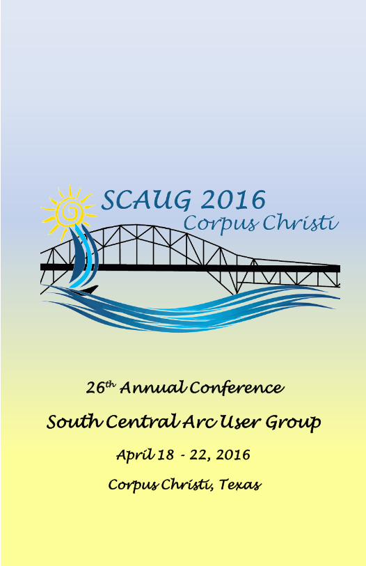
26th Annual Conference
South Central Arc User Group
April 18 - 22, 2016
Corpus Christi, Texas

TABLE OF CONTENTS
Presidential Address 1
SCAUG Officers 2
Training Classes & Workshops 3
A Message from “TUG” the Arcadillo 4
Plenary Speaker 6
Contributor Recognitions 7
Awards 7 - 8
Social Events 10
Save the Date 12 - 13
General Schedule Wednesday, April 20 14 - 15
General Schedule Thursday, April 21 16 - 18
Hands on Learning Lab 19
General Schedule Friday, April 22 20
Esri Technical Session Abstracts 20 - 23
Exhibitor Showcase Abstracts 27 - 29
User Presentation Abstracts 32 - 38
Map Gallery Abstracts 42 - 46
Exhibitor Biographies 47 - 55
GISP Checklist 57
Map Ballot 58
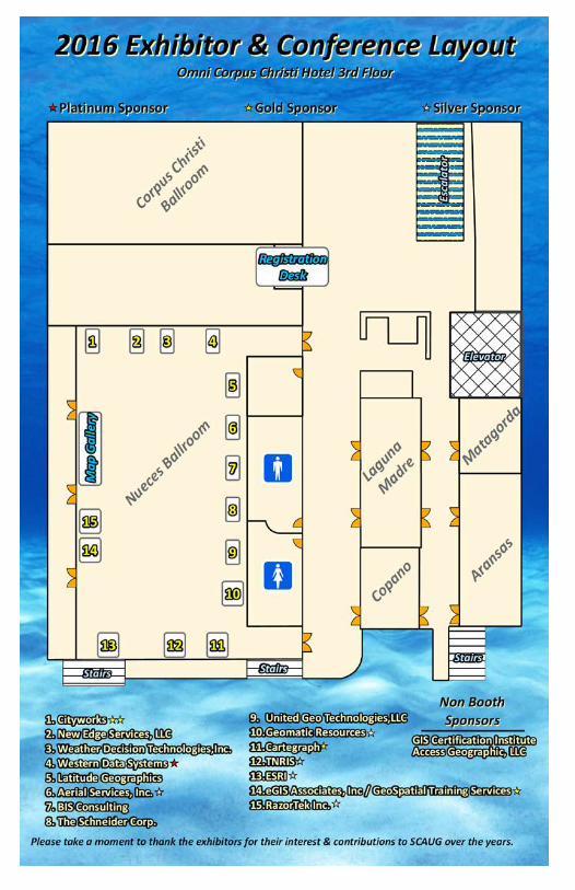
Exhibitor Hall & Meeting Space
Inside Back
Cover
1
PRESIDENTIAL ADDRESS On behalf of the 2015-16 Regional SCAUG Board I would like to
welcome you to the wonderful Texas Gulf Coastal City of Corpus Christi for our 26th Annual Regional SCAUG Conference. We realize that time is one of the most valuable resources you have to offer and we genuinely thank you for choosing to spend it with us. It is our sincere hope that during this week you will enjoy the salt air, excellent content, and valuable time spent enriching your personal GIS skill set.
As the SCAUG region has a diversity throughout the unique eco-regions we all enjoy experiencing we have an equally unique cross section of professionally diverse resources within our membership. GIS is the common operational picture that truly knows no professional boundaries. That common GIS thread has brought our diversity together this week out of a desire to learn from the leaders in our industry as well as from our experienced peers. We strive every year to provide each of you the solid conference content you have come to expect from SCAUG along with incorporating timely new content. Every year’s challenges are different and we want each conference to reflect the new climate we exist within. In choosing a unique conference location we all have a touch of a geographer at heart in us and want to see the diversity that the local region affords. This year we have a newly formed Coastal Bend GIS User Group helping foster the local GIS diversity which we sincerely hope you experience throughout the week.
SCAUG recognizes the increasing need for an individual to further their GIS knowledge and professional development through training and certification. These are the driving forces behind us continuing to provide access to the full suite of online GIS training for all members as well as onsite training as requested. In an effort to help individuals that would like to acquire and maintain their GISP SCAUG has pre-approved activity checklists for this conference as well as a number of other SCAUG hosted events throughout the year. A new development this year is an additional partnership with GIS Certification Institute. Every new GISP recipient, upon completing their new certification, will receive an offer for a one year complimentary SCAUG membership included in their GISP certification packet.
Whether this is your first SCAUG conference or you are a seasoned veteran to the SCAUG membership we welcome you to the 26th Annual Regional SCAUG Conference. Be safe, learn a lot, and enjoy your time with SCAUG in (hopefully) sunny Corpus Christi, Texas this week.
SCAUG OFFICERS Charles Brady III

2
SCAUG OFFICERS President: Charles Brady III, GISP City of Ardmore, Oklahoma
Vice President: Shellie Willoughby, GISP Oklahoma Office of Geographic Information, Oklahoma City, Oklahoma
Treasurer: James Allen Carter County, Ardmore, Oklahoma
Secretary: Anne Mackey, GISP Tarrant County Transportation, Fort Worth, Texas
Conference Coordinator: Lydia Sauceda, GISP CPS Energy, San Antonio, Texas Conference Coordinator Elect: Betsi Chatham City of Fort Worth, Texas
North Texas Representative: Dean Carter Abilene Metropolitan Planning Organization, Abilene, Texas
South Texas Representative: Leslie Morgan Ph.D. GISNuts, San Antonio, Texas
Louisiana Representative: Xingwen Chen Ph.D. ABCD GIS Mapping, LLC, Shreveport, Louisiana
Mississippi Representative: Scott Trapolino, GISP DeSoto County, Hernando, Mississippi
Oklahoma Representative: Will Gustafson, GISP Meshek & Associates, PLC, Tulsa, Oklahoma
Esri Representative: Karen Lizcano Esri - San Antonio, Texas
Mascot: TUG South Central United States

3
TRAINING CLASSES MONDAY, APRIL 18
CLASS ROOM TIME Introduction to ArcGIS Pro for GIS Professionals Aransas 8am - 5pm
Image Analysis with ArcGIS Matagorda 8am - 5pm Programming ArcGIS with Python Copano 8am - 5pm Getting Answers & Solving Problems - An Intermediate Lesson in Spatial Analysis
Laguna Madre 8am - 5pm
TUESDAY, APRIL 19 CLASS ROOM TIME
Introduction to ArcGIS Pro for GIS Professionals Aransas 8am - 5pm
Image Analysis with ArcGIS Matagorda 8am - 5pm Programming ArcGIS with Python Copano 8am - 5pm
Editing Data Using ArcGIS for Desktop Laguna Madre 8am - 5pm
TRAINING WORKSHOPS
FRIDAY, APRIL 22 CLASS ROOM TIME
ArcGIS Tips & Tricks Aransas 8am - 12pm Editing & Maintaining Parcels with ArcMap Copano 8am - 12pm
TxEgrt Training Laguna Madre 8am - 2pm

4
A MESSAGE FROM “TUG” THE ARCADILLO Wow! What a year. It is hard to believe that it is time for the 26th annual conference already. It seems like we just finished the 25th annual conference a few weeks ago. As we get buried in our day to day lives it is always refreshing to take a few minutes to pop your head up and see what is around you. The SCAUG Conference is that chance to get to take a few days to learn some new items, network with colleagues and see what is new in our ever changing GIS world.
Since we were last together in Addison I have traveled across our region attending many SCAUG events. I had the opportunity to visit our conference location in Baton Rouge for the 2017 SCAUG Conference. What a great conference that is going to be! I also had the chance to visit with many of you during the GIS Day events in the fall. Through the winter I hunkered down to get some much needed work accomplished but was able to attend a few events sponsored by SCAUG. Each year SCAUG offers more and more opportunities for our members to get together outside of the conference. Our subchapters and state chapter have done an amazing job of reaching out to the local community and assisting with local GIS needs. It is remarkable how far we have come in our 26 years as an organization and our work is just starting. We have many more areas to explore and more dirt to uncover. We can move the world if we work together and stand united.
I am very excited to get to be back in Corpus Christi. I have great memories of past conferences in the area and I am looking forward to making many new memories. Be sure to check out our facebook page and our website for the latest news on our upcoming events. Keep your eyes out for me through the coming year as I am always out and about. You never know where I will pop my head out.
TUG

5 6
PLENARY SPEAKER
Bern Szukalski
Environmental Systems Research Institute (Esri)
Bern Szukalski has a degree in Biology and Chemistry, and a background in both environmental consulting and biomedical research. A love of maps eventually led him to Esri in 1986 where he began his geospatial career as an applications specialist working on the Peacekeeper Rail Garrison and CIA World DataBank projects. Over the past 30 years at Esri he has held a variety of positions and served in many different roles, covering a broad spectrum of GIS implementation and software development projects. Bern is currently a product strategist and technical evangelist, focusing on ways to broaden access to geographic information and GIS capabilities.
Wednesday, April 20 10:30am – 11:30am
Nueces Ballroom

7 7
CONTRIBUTOR RECOGNITIONS
Conference Guide, Computer Labs & Projectors Lower Rio Grande Valley Development Council 9-1-1 Projectors City of Corpus Christi CORPUS CHRISTI STORYMAP
A big THANK YOU to Heather Scroggins, GIS Technician from the City of Richardson, for creating a storymap showcasing the local area of our conference. Corpus Christi Shortlist is a great resource to find places to eat, play, and visit. Check it out! https://maps.cor.gov/GIS/CorpusChristiShortlist/index.html
AWARD WINNERS
Founders Award Matthew Wormus & the Oklahoma Department of Environmental
Quality GIS Subcommittee, Oklahoma Department of Environmental Quality

8
AWARD WINNERS
Thumbs Up Award
Pamela Jurney, Cross Timbers Consulting, Inc.
Regional Collaborative Scholarship Awards
Francesco Zignol Joe Porter Texas State University Texas State University
Memorial Scholarship Award John Fell, University of Texas at Dallas


10
SOCIAL EVENTS MEET & GREET – OMNI POOL Tuesday, April 19 | 6:00pm – 8:00pm a Join us poolside for relaxation, drinks, and conversation. Each attendee receives 2 drink tickets upon registration material pickup, and they can be used at the Meet & Greet and Exhibitor Reception. EXHIBITOR RECEPTION – NUECES BALLROOM Wednesday, April 20 | 5:00pm – 7:00pm
The official opening of the Exhibitor Hall welcomes everyone to meet exhibitors in a fun social atmosphere. Furthermore, it gives time to make note of what exhibitors they want to formally visit the next day. Don’t forget to acquire Exhibitor Door Prize Tickets from our exhibitors in hopes to win something during the door prize drawings at 3:15pm Thursday, April 21. Must be present to WIN!!! It is also PINT GLASS pick up time – be sure to get one to add to your collection. NEW EDGE SERVICES HAPPY HOUR – EXECUTIVE SURF CLUB Thursday, April 21 | 5:00pm – 8:00pm
NewEdge Services is hosting a Happy Hour providing drinks and appetizers at the locally famous Executive Surf Club at 306 North Chaparral just a few blocks away. RAZORTEK RECEPTION & GAME - HOOKS BASEBALL STADIUM Thursday, Apil 21 | First Ptich 7:05pm
RazorTek is sponsoring an evening at the ballpark with food, drinks, and BASEBALL! Stop by the RazorTek booth for limited wrist bands for entry.

12
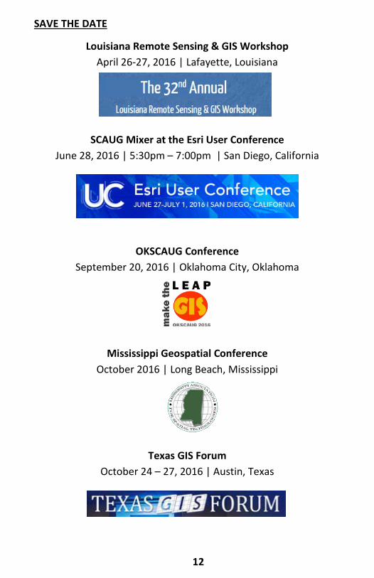
SAVE THE DATE
Louisiana Remote Sensing & GIS Workshop April 26-27, 2016 | Lafayette, Louisiana
SCAUG Mixer at the Esri User Conference
June 28, 2016 | 5:30pm – 7:00pm | San Diego, California
OKSCAUG Conference
September 20, 2016 | Oklahoma City, Oklahoma
Mississippi Geospatial Conference October 2016 | Long Beach, Mississippi
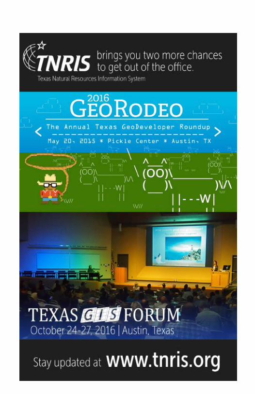
Texas GIS Forum October 24 – 27, 2016 | Austin, Texas
13
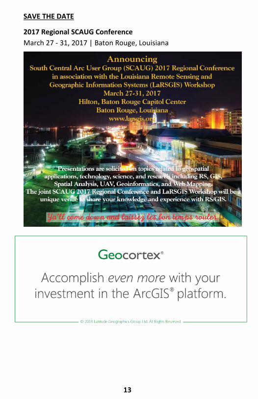
SAVE THE DATE
2017 Regional SCAUG Conference March 27 - 31, 2017 | Baton Rouge, Louisiana

14
GENERAL SCHEDULE WENDESDAY, APRIL 20 REGISTRATION 7:00am - 5:00pm
Pre-function 3rd Floor
OPENING BREAKFAST 7:30am – 9:00am
Nueces Ballroom Sponsored by Western Data Systems
SCAUG BUSINESS 9:00am – 10:15am Nueces Ballroom
The official conference welcome from the SCAUG Board to attendees,
exhibitors, and Esri. Business items include the Year in Review, Conference Agenda and Contributor Recognition, Save the Date, Memorial and Regional Collaborative Scholarship Winners, Founders and Thumbs Up Awards, and
introduction of your 2016-2017 SCAUG Board.
BERN SZUKALSKI PLENARY 10:30am - 11:30am Nueces Ballroom
LUNCH ON YOUR OWN 11:30am - 1:30pm
MAP GALLERY POSTERS DUE 2:00pm
Registration Pre-function 3rd Floor
Session Track I Esri Technical Sessions 1:30pm - 2:30pm
Copano Laguna Madre Matagorda
Get Out! Karen Lizcano & Pam Kersh
Land Records Solutions in a Tech
Savvy World Dan Stone
Tell Your Story Bern Szukalski

GENERAL SCHEDULE WENDESDAY, APRIL 20
Esri Technical Sessions II 2:45pm - 3:45pm
Copano Laguna Madre Matagorda
Are You Ready for THE Flood?
Veronica Schindler & Keith Kite
Successful Engagement with
What’s New in ArcGIS Online
Pam Kersh
Getting to Know ArcGIS Pro
Miriam Schmidts
Session Track III Esri Technical Session 4:00pm - 5:00pm
Copano Laguna Madre Matagorda
Front and Center, Making Great Maps in
a Digital Age Karen Lizcano
Does your Data Have Harmony Dan Stone
Getting to Know ArcGIS Pro
Miriam Schmidts
EXHIBITOR HALL RECEPTION 5:00pm - 7:00pm
Nueces Ballroom Sponsored by eGIS Associates & Geospatial Training Services
15

16
GENERAL SCHEDULE THURSDAY, APRIL 21
REGISTRATION 7:30am – 2:30pm Pre-function 3rd Floor
CONTINENTAL BREAKFAST 8:00am – 9:00am
Nueces Ballroom Sponsored by Esri
EXHIBITOR HALL & MAP GALLERY 8:00am - 4:00pm
Nueces Ballroom
Please tear out Map Gallery Ballot in the back of conference guide, cast your vote for your favorite map, and submit ballots at registration desk no later than
1:00pm on Thursday, April 21
ESRI HANDS ON LEARNING LAB 8:00am - 5:00pm
Aransas
Come get FREE hands-on Esri training!!! 22 different lessons available which are 45-minutes and self-guided. Esri Solution Engineers available for assistance.
Lesson Listing on page 19 Sign-up in Aransas ~ First Come, First Served
SESSION TRACK I Exhibitor Showcases 9:00am - 9:30am
Copano Laguna Madre Matagorda Leveraging a
GIS-Centric Asset Management System
After a Disaster Aaron Kreag
Creative GIS Solutions for Local Government
Andrew Harrison
Insight - Advances in GIS Technology
Scott Stafford-Veale

17
GENERAL SCHEDULE THURSDAY, APRIL 21
SESSION TRACK II Exhibitor Showcases 9:45am -10:15am
Copano Laguna Madre Matagorda
Understanding the NewEdge Cloud &
Unique ID Tool Gary Parker & Robbie
Schermerhorn
The Texas Advantage - How Texas will Benefit
from Public-Private Richard Wade,
Felicia Retiz, & Kara Manton
Proven Aerial Remote Sensing Solutions for
Efficient Pipeline Planning & Integrity
Management Chuck Boyer
SESSION TRACK III User Presentations 10:30am - 11:30am
Copano Laguna Madre Matagorda
Where Can I Build That? Mapping
Entitlements Across McKinney
Neil Rose & Alexis Green
Mobilize Your Workforce with ArcGIS
Online Ramon Campos
Be Flood SAF(ER) – Situational Awareness
For Emergency Response – A River
Flooding Extent Map Viewer
Jared Allen Improving Flash Flood
Response with an ArcGIS Online Road
Closure App Greg Brown
& Corey Baker
3D Interior Space Scanning On A Budget
J. Scott Sires
EXHIBITOR LUNCHEON 11:30am – 1:00pm Nueces Ballroom
Network with Exhibitors over lunch and conversation. Be sure to cast your Map Gallery vote and submit your ballot by 1pm at the Registration Desk

15 18
GENERAL SCHEDULE THURSDAY, APRIL 21
SESSION TRACK IV User Presentations 1:00pm - 2:00pm
Copano Laguna Madre Matagorda Engineering &
Mapping a Major Water Pipeline
Michael A. Garza Designing a GIS for
Facilities Management & Distributing Through
Story Maps Tony Guzman
& Brad Daugherty
GIS & Next Generation 9-1-1: What It All
Means Amy Rose & Kasey Cox
The 3D Elevation Program (3DEP)
Claire DeVaughan
SESSION TRACK V User Presentations 2:15pm - 3:15pm
Copano Laguna Madre Matagorda
State of the GISCI & the GISP
Richard Smith
GIS Products and Services at the
National Weather Service in Corpus
Christi, Texas Michael Buchanan
GIS in the World of a 9-1-1 COG
Sergio Castro
Batch Groprocessing using Python to
Manage Data Efficiently
Xingwen Chen P2 Energy Solutions
Alyssa Geyer, Erin Ukestad,
& Sharmila Partab
EXHIBITOR DOOR PRIZES & MAP GALLERY WINNERS 3:15pm – 4:00pm Nueces Ballroom
Last chance to connect with exhibitors!!! The Map Gallery Winner will be
announced along with Exhibitor Door Prize Winners being drawn. MUST BE PRESENT to win Exhibitor Door Prizes.

19
HANDS ON LEARNING LAB Thursday, April 21 8:00am – 5:00pm | Aransas
The Hands-on Learning Lab (HOLL) is a training resource provided and developed by Esri Training Services, and is an excellent way to introduce ArcGIS users to a variety of Esri software solutions and training opportunities while learning to use Esri software. The best part is that it is FREE with conference registration!!! Attendees will be able to sign up for lessons during HOLL hours of 8am to 5pm on Thursday, April 21st. The HOLL consists of a group of laptops with headphones where students can work through lessons at their own pace. A lesson consists of a recorded presentation followed by a hands-on exercise. Each lesson typically takes about 45 to one hour to complete and students can generally come and go as they please. Education Services instructors are on hand to assist users with questions.
LESSONS
1. Getting Started with GIS 1: Understanding the ArcGIS Platform 2. Getting Started with GIS 2: Using ArcMAP to Explore GIS Data 3. Getting to Know ArcGIS Pro 4. Advantages to Storing Your GIS Data in the Geodatabase 5. Creating Presentation Quality Maps in ArcMap 6. Editing GIS Data in ArcMap 7. Multi-user Editing Using Versioning 8. Editing and Maintaining Parcels Stored in a Parcel Fabric 9. Geocoding Street Addresses to Create Map Points 10. Importing and Preparing CAD Data for Use in ArcGIS 11. The Importance of Spatial Reference in Tactical Applications 12. Exploring Health and Epidemic Patterns Using Spatial Statistics Tools 13. Optimizing Transportation Routs Using ArcGIS Network Analyst 14. Modeling Time and Distance Along Networks Using Linear Referencing 15. Working with Geometric Networks to Manage Utilities 16. Interpolating Sample Points to Create Rasters Using Spatial Analyst Tools 17. Geoprocessing GIS Data Using Python 18. Sharing Maps and GIS Content Using ArcGIS Online 19. Understanding Web Services Using ArcGIS for Server 20. Generating Web Applications for the GIS Novice 21. Getting Started with the Community Maps Data Preparation Tools 22. Mapping Excel Data Using Esri Maps for Office

20
GENERAL SCHEDULE FRIDAY, APRIL 22 TRAINING WORKSHOP ROOM TIME
ArcGIS Tips & Tricks Aransas 8am - 12pm Editing & Maintaining Parcels with
ArcMap Copano 8am - 12pm
TxEgrt Training Laguna Madre 8am - 2pm
SUBCHAPTER & SPECIAL INTEREST
GROUP MEETINGS ROOM TIME
CBGIS User Group Meeting Matagorda 8:30am - 10am
9-1-1 South Region Planning Group Meeting Matagorda 10am - 12pm
ESRI TECHINICAL SESSION ABSTRACTS Wednesday, April 20
SESSION TRACK I 1:30pm – 2:30pm
Get Out! Copano Karen Lizcano & Pam Kersh
A variety of mapping applications are available to help you improve field operations and make more informed business decisions. Esri continues to release, update and modernize the options available to get your content out into the field and on portable devices. During this session we will look at some of the newest options including Workforce, Navigator, Survey123 and Collector. By utilizing these solutions you can get out, get work done and improve operation efficiency, making you the mobile data hero! Land Records Solutions in a Tech Savvy World Laguna Madre Dan Stone
What can The Land Records Solutions do for YOU? • manage an accurate inventory of real property

21
ESRI TECHINICAL SESSION ABSTRACTS Wednesday, April 20
• see details of who owns the land • analyze land value and the associated improvements • help maximize tax property revenue All of this is available in supported, configurable templates! Come and see from one of our Land Records Experts how these maps can be used by everyone, from appraisers in the field, to office staff, that provide quick access to essential information, to the public, who want easy access in a modern format. By leveraging these solutions you are empowering your constituents to quickly and easily get the information they are seeking. b Tell Your Story Matagorda Bern Szukalski
Everyone has a story. What's yours? Esri Story Maps let you combine authoritative maps with narrative text, images, and multimedia content. They make it easy to harness the power of maps and geography to tell your story. During this session one of Esri’s story map experts will highlight some of our newest story maps and show you how to easily configure and deploy your story in a way that can engage your community, communicate with constituents, inform decision makers, and fire up your supporters.
SESSION TRACK III 2:45pm – 3:45pm
Are You Ready for THE Flood? Copano Veronica Schindler & Keith Kite
Make sure your organization has the capabilities, resources, and tools it needs to weather the storm and safeguard your community. Esri is ready to help you before, during, and after major rain events with Solutions for Flood, a specially designed solution to help you face record-setting rains. Solutions for Flood includes everything your organization needs to defend your community and prepare for an emergency. You can inspire public confidence in your organization with
22
ESRI TECHINICAL SESSION ABSTRACTS Wednesday, April 20
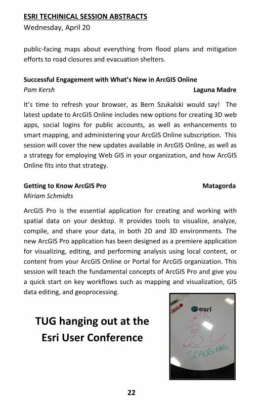
public-facing maps about everything from flood plans and mitigation efforts to road closures and evacuation shelters. Successful Engagement with What’s New in ArcGIS Online Pam Kersh Laguna Madre
It’s time to refresh your browser, as Bern Szukalski would say! The latest update to ArcGIS Online includes new options for creating 3D web apps, social logins for public accounts, as well as enhancements to smart mapping, and administering your ArcGIS Online subscription. This session will cover the new updates available in ArcGIS Online, as well as a strategy for employing Web GIS in your organization, and how ArcGIS Online fits into that strategy. Getting to Know ArcGIS Pro Matagorda Miriam Schmidts
ArcGIS Pro is the essential application for creating and working with spatial data on your desktop. It provides tools to visualize, analyze, compile, and share your data, in both 2D and 3D environments. The new ArcGIS Pro application has been designed as a premiere application for visualizing, editing, and performing analysis using local content, or content from your ArcGIS Online or Portal for ArcGIS organization. This session will teach the fundamental concepts of ArcGIS Pro and give you a quick start on key workflows such as mapping and visualization, GIS data editing, and geoprocessing.
TUG hanging out at the Esri User Conference
24 23
ESRI TECHINICAL SESSION ABSTRACTS Wednesday, April 20
SESSION TRACK III 4:00pm – 5:00pm
Front and Center, Making Great Maps in a Digital Age Copano Karen Lizcano
You collect data, ensure accuracy and perform analysis. Now it’s time to shine by effectively communicating your message through modern and meaningful digital media. During this session we will look at different ways to create and share maps leveraging ArcGIS Online. We’ll discuss web maps, web mapping applications and the WebApp Builder. We will also look at some of the new features that you can include in your modern mapping solutions. b Does Your Data Have Harmony? Laguna Madre Dan Stone
ArcGIS for Local Government is based on a harmonized information model of GIS datasets, web services, and maps that we commonly refer to as the Local Government Information Model (LGIM). The LGIM's design reflects specific application requirements and the cartographic design elements necessary to produce rich, multiscale basemaps and operational layers. This session will discuss the benefits of the LGIM, and the tools and best practices for implementing the LGIM, maps, and apps. Getting to Know ArcGIS Pro Matagorda Miriam Schmidts
ArcGIS Pro is the essential application for creating and working with spatial data on your desktop. It provides tools to visualize, analyze, compile, and share your data, in both 2D and 3D environments. The new ArcGIS Pro application has been designed as a premiere application for visualizing, editing, and performing analysis using local content, or content from your ArcGIS Online or Portal for ArcGIS organization. This session will teach the fundamental concepts of ArcGIS Pro and give you a quick start on key workflows such as mapping and visualization, GIS data editing, and geoprocessing.

Leica Geosystems provides powerful asset management solutions that are easy to use. From inexpensive hand held data collection devices to fully configurable and completely accessible enterprise class GIS/Asset Management solutions. We offer solutions with easy data upload/download capabilities allowing field technicians to complete entire projects remotely without ever stepping foot in the office.
Please contact me to discuss your requirements:
Colin M.H.A. Fletcher Geomatic Resources, LLC 2914 West Story Road Irving, TX 75038 817.631.3207 [email protected] www.geotx.com
Dan Rodriguez
Satellite and Aerial Mapping
Services Products
-Image processing -Aerial Photography
-Data Conversion -Satellite Imagery
-Data development -LiDAR
-Web programming -LizardTech (MrSID)
-Data extraction -GeoExpress
-MrSid compression -ESRI products
-MrSid reprojection -ArcGIS 10.2.1
-MrSid Mosaic -Extensions
-Address Geocoding -Terrago software
-GPS processing -Terrago Edge
www.razor-tek.com [email protected]
(901)-922-5448
EXHIBITOR SHOWCASE ABSTRACTS Thursday, April 21
SESSIONTRACK I 9:00am - 9:30am
Leveraging a GIS-Centric Asset Management System After a Disaster Aaron Kreag, GISP, Regional Sales Manager Copano Cityworks
In a post disaster scenario FEMA will mobilize resources and free up funding for a rescue or recovery effort. Organizations have a responsibility to properly track and report on fiscal activity and resource utilization as they progress and seek funding or reimbursement. This presentation will take a brief look at the applicability of the Cityworks & ESRI platforms and how they may be leveraged by local government in a post disaster environment.
Creative GIS Solutions for Local Government Laguna Madre Andrew Harrison, GISP, Director of Business Development The Schneider Corporation
Our presentation covers how communities around the country have been providing creative solutions to today's problems using GIS. This presentation is composed of case studies on how other communities have solved their time and budget problems with innovative GIS ideas; by using best practices for inventory of assets, utilizing damage, identifying and tackling large scale GIS, implementing cemetery mapping, and the simplicity of managing online permitting. The goal of this presentation will be to share many different ideas for GIS use and for you to leave the session with new ideas that you can try yourself.

28
EXHIBITOR SHOWCASE ABSTRACTS Thursday, April 21
Insight - Advances in GIS Technology Matagorda Scott Stafford-Veale Latitude Geographics
Everybody works better when organizations have control over their systems and can manage their performance. Better yet, spend less time monitoring your sites and let your system tell you when important events are happening. This presentation will introduce and demonstrate how organizations can ensure the smooth running of their ArcGIS Server, AGOL, Portal (and Geocortex) infrastructure by employing new technology that alerts managers to potential issues, and raises alarms if needed, in real time. Immediate notification means you can address problems as soon as they arise, minimizing downtime and ensuring performance for end-users.
SESSIONTRACK II 9:45am – 10:45am
Understanding the NewEdge Cloud and Unique ID Tool Copano Gary Parker, System Administrator, NewEdge Services, LLC Robbie Schermerhorn, GIS Specialist, NewEdge Services, LLC
NewEdge Services, LLC has been at the forefront of cloud hosting services within the GIS industry with our longest standing cloud client being online for almost 4 years. NewEdge offers our clients multiple options for hosting GIS and/or Cityworks and other related applications in the Amazon cloud. This vendor showcase will demonstrate the technical aspects of the NewEdge Cloud environment as well as address some of the common misunderstandings of a cloud hosted solution. In addition, NewEdge has developed an ID tool that allows users to customize unique IDs within their geodatabase to meet client specific needs. The tool automatically assigns IDs that are unique within the entire database as GIS editing occurs without the need for a customized tool installed on each editor endpoint. During the showcase, we will demonstrate the functionality of the tool and discuss the multiple deployment options available.

29
EXHIBITOR SHOWCASE ABSTRACTS Thursday, April 21
The Texas Advantage - How Texas will Benefit from Public-Private Partnerships Richard Wade & Felicia Retiz, TNRIS Kara Manton, Applied Geographics, Inc. Laguna Madre Proven Aerial Remote Sensing Solutions for Efficient Pipeline Planning & Integrity Management Matagorda Chuck Boyer, Director of Geospatial Solutions Aerial Services, Inc. LiDAR and aerial imagery are the safest and most economical ways to collect and produce geospatial mapping for the Oil and Gas industry. I will show, from past experience, how you can collect data for a oil or gas pipeline and save time and money on the front end of a project. I will also show how millions of dollars can be save on the back end of projects because you collect millions of points during a project and can use them when you need them. Lidar is also able to show High Consequense Areas, avoiding catastrophic event and saving lives.


32
USER PRESENTATION ABSTRACTS Thursday, April 21st
SESSIONTRACK III 10:30am - 11:30am
Where Can I Build That? Mapping Entitlements Across McKinney Neil Rose, GIS Planner & Alexis Green, GIS Analyst Copano City of McKinney, TX
The City of McKinney regulates land use entitlements through zoning districts. Each district defines the allowable land uses, which are outlined in a Schedule of Uses. This Schedule of Uses includes over 250 unique land uses. Given the variety of land uses that could be allowed in a single zoning district, plus the City’s heavy reliance on Planned Development Districts (districts that allow land use flexibility), geospatially locating allowable land uses was unfeasible. An interactive web application was developed in collaboration with Planning, GIS, and IT to help staff and end users determine where certain land uses can be located based on zoning. Self-service generation of spatial information allows for a reduction of research time in response to customer inquiries and has improved staff’s ability to analyze land use data. The web app features a geoprocessing service built with Model Builder & python scripting that is consumed via Web AppBuilder. Mobilize Your Workforce with ArcGIS Online Copano Ramon Campos, GISP, GIS Manager Tarrant County Information Technology, Tarrant County Business Application Development & Support
Leveraging ArcGIS Online and Collector for ArcGIS , your workforce can be in the field collecting and updating data in minutes. See how Tarrant County is using ArcGIS for Server, ArcGIS Online, and Collector to improve efficiency and accuracy of its sign field crews in the Transportation Department.

33
USER PRESENTATION ABSTRACTS Thursday, April 21st
Be Flood SAF(ER) – Situational Awareness For Emergency Response – A River Flooding Extent Map Viewer Laguna Madre Jared Allen, Senior Meteorologist, GIS Focal Point NOAA/National Weather Service - Austin/San Antonio, TX
Situational awareness of river flooding and its time evolution through the use of flood extent mapping is critical for emergency management resource allocation, decision making, and overall public alertness. To increase decisive information for emergency responders, the Austin/San Antonio, TX National Weather Service (NWS) office has developed a prototype ArcGIS Online (AGOL) web mapping application called Flood SAF(ER). This application displays current radar, weather warnings, observed, and forecast river heights, plus their respective hydrographs. More importantly, this viewer links to a basic and advanced AGOL web map that spatially depicts modeled river flood extents for critical impact categories (minor – record NWS stages). With knowledge of the critical infrastructure and neighborhoods at risk during a river flooding episode, decision makers can use this application and its respective GIS layers to develop a timeline for decisive action planning and city/county coordination.
Improving Flash Flood Response with an ArcGIS Online Road Closure App Laguna Madre Greg Brown, GIS Dept, City of New Braunfels, TX Corey Baker, Account Manager, GISinc
The City of New Braunfels, TX uses web and mobiles applications to respond in real time to recent flood events that create dangerous road crossings.

34
USER PRESENTATION ABSTRACTS Thursday, April 21st
3D Interior Space Scanning On A Budget Matagorda J. Scott Sires, Geospatial Technology Program Professor & Coordinator Brookhaven College Geospatial Technology
This session demonstrates and discusses low-cost, emerging technologies applied to create high-density 3D point cloud data sets. The method requires a 64-bit tablet, a $500 scanning sensor and optional items that are easy to utilize. Brookhaven College Geospatial students invested a Fall 2015 semester course researching this methodology. Scans require less than 30 minutes, are then processed into a point cloud and spatially adjusted to real world coordinates. The developed SOP will be provided.
SESSIONTRACK IV 1:00pm – 2:00pm
Engineering and Mapping a Major Water Pipeline Copano Michael A. Garza, GISP Pape-Dawson Engineers
This project consists of the design of a major water pipeline that crosses seven counties and roughly 500 parcels to help supplement water to the dwindling Edwards Aquifer water source in Bexar County. Pape-Dawson Engineers created multiple GIS websites, for both desktop and mobile devices, that allowed several agencies to collect data in real-time. This allowed the Project managers, Engineers, Environmentalist, and Board members to view and access GIS websites and dashboards in order to see the status of each parcel and if there were any issues that might interfere in the alignment of the waterline. GIS was the only tool that allowed for the multiple agencies and decision makers to coordinate and collaborate their decisions based on real time data.

35
USER PRESENTATION ABSTRACTS Thursday, April 21st
Designing a GIS for Facilities Management and Distributing Through Story Maps Copano Tony Guzman, GIS Specialist, Midland Independent School District Brad Daugherty, President, NewEdge Services, LLC Midland Independent School District (MISD) has been developing GIS data for facilities using aerial photography and GPS for several years. MISD realized a need for a more robust geodatabase design to meet current needs and to realize future expectations. MISD contracted NewEdge Services, LLC to assist with a database design. The team utilized MISD’s existing data, Esri local government template, and Esri facilities data model to develop a comprehensive data model for the District. Procedures were implemented to allow GIS users to access other data sources (ex. CAD floor plans, original construction and as-built plans, bid documents, warranties, contracts, etc.) via the GIS. The GIS information is shared throughout the District’s network via an ArcGIS Flex Viewer application as well as through a Story Map. The presentation will review the components of the database design and demonstrate how the web applications are used to access a variety of information.
GIS and Next Generation 9-1-1: What it All Means Laguna Madre Amy Rose, 9-1-1 GIS Analyst II & Kasey Cox, 9-1-1 GIS Technician II North Central Texas Council of Governments
Next Generation 9-1-1 (NG9-1-1) places GIS at the core of emergency call routing. In the current E9-1-1 system, GIS is primarily used for map display and call plotting. Much of the driving force behind NG9-1-1 is due to advancements in IP based technologysuch as smart devices and telematics systems. So what does this all mean and how might it affect you? Visit us for a presentation that will provide:
• A high level overview of the role of GIS in NG9-1-1.
36
USER PRESENTATION ABSTRACTS Thursday, April 21st
• What NG9-1-1 could mean for local GIS data creators now and in the future. • Ways you can become involved and keep informed about NG9-1-1 GIS.
The 3D Elevation Program (3DEP) Matagorda Claire DeVaughan, National Map Liaison for OK and TX U.S. Geological Survey
The 3D Elevation Program (3DEP) is being developed to respond to growing needs for high-quality topographic data and for a wide range of other three-dimensional representations of the Nation's natural and constructed features. The primary goal of 3DEP is to systematically collect enhanced elevation data in the form ofhigh-quality light detection and ranging (lidar) data over the conterminous United States, Hawaii, and the U.S. territories, by the end of 2022. Benefits of such data apply to flood risk management, agriculture, water supply, infrastructure management, and aviation safety. This presentation will describe lidar basics, show examples of lidar usage in various applications, discuss recommendations for the emerging lidar technologies of “Single Photon Counting” and “Geiger Mode”, and provide information on 3DEP program status and planning tools.
SESSIONTRACK V 2:15pm – 3:15pm
State of the GISCI and the GISP Copano Richard Smith, Ph.D., GISP, Board Member, GISCI Board of Directors
This presentation will introduce the GIS Certification Institute (GISCI) and provide an overview of the mission, current status, and future of the GISCI. Additionally, the GIS Professional (GISP) certification program’s current status and future direction will be introduced and discussed. Lastly, as part of the GISP program discussion, the development, distribution, and maintenance of the GISP examination will be presented.
37
USER PRESENTATION ABSTRACTS Thursday, April 21st GIS Products and Services at the National Weather Service in Corpus Christi, Texas Laguna Madre Michael Buchanan, Science and Operations Officer National Weather Service Corpus Christi, Texas
Since 2007, the National Weather Service office located in Corpus Christi, Texas has developed a variety of GIS products and services for their local, regional, and national customers and partners. High resolution PNG graphics, KMZ files, and Web Mapping Services of weather and climate information are routinely created using a multitude of Python scripts. These GIS products and services are used to brief customers and partners on routine and significant weather impacts through a variety of email, web, and social media platforms. The easy-to-understand format of these GIS products and services greatly assists customers and partners in making critical weather-related decisions.
GIS in the World of a 9-1-1 COG Laguna Madre Sergio Castro, LRGVDC 9-1-1
Many of us know that GIS is used throughout the world for many different things such as oil and gas, education, environment and science. However, in the world of 9-1-1, GIS has an important significance since we use this technology for many things. One of the main usage of this technology is for saving peoples lives. In this session, you we see how LRGVDC utilizes GIS in mostly every aspect of 9-1-1. You will also understand why we feel that GIS is now the heart and soul of 9-1-1.
TUG welcomes you to the Third Coast

38
USER PRESENTATION ABSTRACTS Thursday, April 21st Batch Groprocessing using Python to Manage Data Efficiently Xingwen Chen, President Matagorda ABCD GIS Mapping
In the process of mapping oil/gas mineral ownership, we often need to assemble data from different sources, formats, datum, and projections. Data usually come in by counties such as Surface Well Locations & Bottom Holes, and some are state level data, such as landgrid (Texas Original Land Survey). The goal is to process these data sets and save in a geodatabase, re-define projections, project all data in the same DATUM & projection, query for subset of data, calculate fields, and convert all data layers to sequential list of points with latitude/longitude that are to be used in customized applications. Python and PyScripter are used to program the whole process in a batch mode. Multiple counties of data may be process at once.
P2 Energy Solutions Matagorda Alyssa Geyer, Erin Ukestad, Sharmila Partab P2 Tobin Data Production Image Service
This presentation will explore the challenges and successes of P2 Energy Solutions’ effort to migrate vintage aerial imagery and land grid to a raster-based image service. Because this project results in easier access to raster resources, there has been improvement in the data operations production efforts. A few challenges that have arisen since the implementation of the image service include conversion of various image types and staffing for detail-intensive tasks. P2 Energy Solutions offers a series of Tobin Data packages containing Vintage and Custom Aerial Imagery, Survey, Lease, Ownership, and Well data to upstream oil and gas exploration and production companies since 1928.
42
MAP GALLERY ABSTRACTS A Tornado the Day After Christmas!?! Bret Fenster, Kendall Holland, Ramona Luster, Gabi Voicu, Khyati Desai and Tim Nolan, Collin County, Texas GIS
“Remember… tornado season in Texas is January 1st – December 31st.” – David Finfrock, Chief Meteorologist, NBC 5 News, Dallas-Ft Worth. If the conditions are right, a tornado can occur at any time. Devastating tornadoes roared through Ellis, Dallas and Collin Counties the day after Christmas. Much of our rescue and recovery efforts weretaxed due to the holiday. Collin County GIS staff, in coordination with the Texas Emergency GIS Response Team (TX EGRT) and local authorities, built an ArcGIS Online (AGO) interface to display structures effected by the tornadoes. The AGO site served as a single repository for site pictures, building conditions and the eventual tornado paths. Collin County enlisted the help of Pictometry International to fly and take imagery of the tornado damage. We were able to see before and after images of the structures in the affected areas. This maps shows some of the early data collection effort, the tornado paths and the imagery of the destruction. Influence of the utopian Reunion Colony settlers in early Dallas, Texas. as evidenced by pattern of historical street names in the present Downtown, Deep Ellum, and Old East Dallas areas. Albert Dwayne Taylor, City of Dallas, Texas
French philosopher Francois Marie Charles Fourier developed ideas in the early 1800’s on how to create a productive, nonrepressive society, free from disorder, chaos and strife, through harmonious collaboration and elimination of tedious or unpleasant work through communal associations. This became popular as a reaction to the French Revolution and Napoleonic era earlier in the century. An early collaborator, Victor Prosper Considerant, defined the idea of a “right to (have) work” as one the main ideas of French Socialists in the 1848 Revolution in France (one of a wave of revolutions in Europe that year), which ended with the defeat of insurrectionists by forces loyal to Louis
43
Napoleon Bonaparte, followed by repression of his opponents, including Considerant and other followers of utopian Fourierism movement, who were forced into exile in Belgium. Considerant, with the help of other exiles, began planning the establishment of a colony in North America. With the assistance of advance agent Francois Cantagrel, a site was found in Dallas County in 1952, with the first settlers, perhaps 200-350 (the just established town of Dallas had approximately the same population), arriving in 1855 and establishing their colony in what is now considered "West” Dallas, or “Far West” Oak Cliff. As most of the settlers were from urban backgrounds, possessed artisan rather than agricultural skills, and settled on land ill suited for farming at a time of drought and periodic hard freezes, their utopian agricultural colony was officially dissolved in 1957, and most of the colonists had reported left the settlement by 1860. Many of those who left moved back to Europe or to New Orleans, but perhaps half remained in Texas, many in Dallas, and a few purchased their La Reunion holdings and remained there permanently. Of those who remained in Dallas, many are reported to have moved into the area which later became known as Deep Ellum and Old East Dallas. The map will attempt to show the diffusion of their influence in that part of Dallas by the distribution of street names related to the former Reunion Colonists, with which the author, as street name coordinator for the City of Dallas, has become familiar through the course of his work. US 75 Corridor – Retail Trade Analysis 2002-2014 Bret Fenster, GISP, County of Collin, Texas
Rather than funding US 75 highway improvements through a tollway designation, Collin County is looking at innovative ways of funding improvements by capturing a portion of new sales tax revenues in the highway corridor. Revenue projections will be provided to the Texas Legislature in order to assess the viability of diverting future sales taxes towards corridor improvements. This study shows Texas State Comptroller retail trade data portrayed in graphs. The graph data correlates to the highway corridor and retail zoning areas in the cities.

44
The desired goal is keeping the lanes on a busy regional highway free from tolls and improving the mobility of the citizens in Collin County. Creating a Geographical Information System (GIS) Database for Documenting Historical Structures at Rancho La Union Ranch, Zapata County, Texas. Brent C. Hedquist Department of Physics & Geosciences, Texas A&M University-Kingsville Mukti R. Subedi, Department of Physics & Geosciences and Department of Biological & Health Sciences, Texas A&M University-Kingsville
As one of the oldest continuously operating ranches in South Texas, Rancho La Union contains several historical structures of significance. It is critical that these historical structures are documented digitally and mapped for documentation and preservation purposes. This project involved the design and creation of a geodatabase and reference map that can be added to in the future and allow prospective visitors to view and read about historical building and structures from a website. The design of the geodatabase included defining the domains and subtypes for roads, buildings, and a corral, as well as digitizing the roads, corral, dam, and buildings on the ranch property. The final map (a GeoPDF) created in the project will aid in identifying the location of the historical ranch in South Texas, as well as key structures that have existed for over 150 years on the property, such as the corral and bunkhouse.

45
Finding Your Safe Space Collin King & Bre Caller, BIS Consulting
Abstract: Using spatial analysis, we will be discovering which areas of Dallas county will be the safest in the event of a storm system producing a tornado. By dividing Dallas county into quadrants, taking fatalities, injuries, damages, EF rating, and distance covered by all tornadoes since the 1950’s into account, and determining which quadrant would be the safest to settle if you were moving into the Dallas county area for the first time. This will be informative for various reasons, including the safest area statistically in the event of a tornado, and if you choose to move to another area in Dallas county, being informed enough to know that you are more likely to be hit by a tornado and should take necessary measures to prevent yourself from being the next victim. Tornadoes: Paths through time Bre Caller & Collin King, BIS Consulting
A category EF4 tornado, with winds of up to 180 mph, ripped through the eastern Dallas metroplex on December 26, 2015. Dallas has not seen a tornado of this intensity since 1959. BIS Consulting is producing a poster to show the impact of the 2015 tornado using a buffer analysis of the track and an intersect of the 2015 parcel data to show the estimated number of properties affected. We will also be comparing the damage caused by the two tornados in 2015 terms and investigating what damage the 1959 tornado track would have caused today. Ozone Trend Analysis over Time and Geography: Houston, TX Johnny Brown, Harris County & Nicole Bradstreet, CDM Smith
The aim of this study was to visualize what effect regulation had on ozone values near Houston, Texas and to determine the influence of land use features. This was done by employing eleven years (2004-2014) of air quality data provided by the Texas Commission on Environmental Quality via the U.S. Environmental Protection Agency. The data includes daily max ozone values for this entire time period, however, visualization contained in the study area demonstrates yearly
46
average AQI (air quality index) values. Temporally, values declined overall by approximately ten percent when comparing 2008 (when regulation capped ozone to 75 ppb) to 2014. Spatially, the greatest decrease in ozone emissions (2014/2008) occurred in rural areas (-19.9%), near airports (-12.06%), and in highway corridors (-11.77%). The smallest amount of decrease occurred in industrial areas (-7.74%) and beach/bay areas (-8.3%). Suburban and urban areas experienced decreases in the -9/-10% range. GIS Products and Services at the National Weather Service in Corpus Christi, Texas Michael Buchanan, National Weather Service Corpus Christi, Texas
Since 2007, the National Weather Service office located in Corpus Christi, Texas has developed a variety of GIS products and services for their local, regional, and national customers and partners. High resolution PNG graphics, KMZ files, and Web Mapping Services of weather and climate information are routinely created using a multitude of Python scripts. These GIS products and services are used to brief customers and partners on routine and significant weather impacts through a variety of email, web, and social media platforms. The easy-to-understand format of these GIS products and services greatly assists customers and partners in making critical weather-related decisions.
59 47
EXHIBITOR BIOGRAPHIES
PLATINUM SPONSORSHIP
Western Data Systems is an authorized Trimble Dealer specializing in the sales, rentals, training and
technical support for Survey, Mapping, Marine, Utility, Environmental, Fleet Management and Seismic Industries. WDS was founded in 1982 and since then has concentrated on supplying top of the line Spatial Measurement and GPS related products in Texas and Oklahoma for sales and worldwide for rentals. We offer several peripheral items such as pipeline locators, ground penetrating radars, laser rangefinders, laser scanners, GPS cameras, barcoders, tablets and much more. WDS has two full Survey Supply stores in Texas and delivers wood, stakes, flags and any supply needed daily. With our extensive rental fleet we have more than enough gear to get you through any job and can ship worldwide. Our Technical Support staff is comprised of a staff that has worked in the field and can help out with any support need you have. We offer free support to both our rental and sales customers. WDS also manages the largest private VRS Network in the world. This network is available to both Survey and Mapping communities. We are adding base stations continuously and the amount of users grows each year. For a full line of our products and Services please visit our website at www.wds-us.com. With six offices across Texas and Oklahoma you are never too far from The Experts!
GOLD SPONSORSHIPS
Since 1996, Cityworks® has been streamlining the way agencies manage public infrastructure and
property. Built exclusively on Esri’s ArcGIS technology, the Cityworks GIS-centric platform leverages the authoritative asset inventory maintained in the geodatabase to manage workflow, schedule resources and prioritize activities—

48
saving time and money while improving operational efficiencies. Time-tested and proven technology, Cityworks is Empowering GIS® at more than 600 user sites around the world. Learn more at www.cityworks.com.
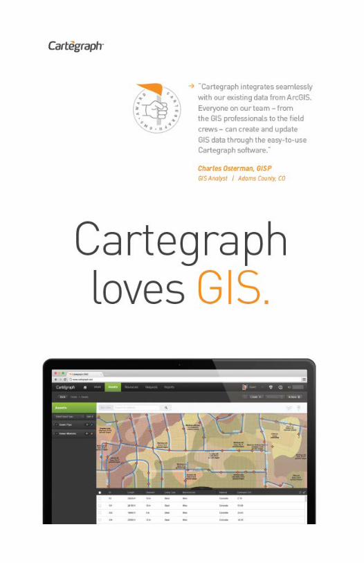
The Cartegraph Operations Management System is designed and built to help public sector
organizations save time and money. With its emphasis on adoptability, user experience, and return on investment, Cartegraph technology helps organizations effectively manage the work, assets, resources, and requests at the center of their day-to-day operations.
eGIS Associates, Inc. is focused on providing efficient and cost effective Geospatial Solutions that meet the growing needs of public and private
sector enterprises. Our mission is to help you consume the "Power of Place" with current technology standards and Applied Spatial Intelligence ©.eGIS offers a wealth of professional products and services including:
• Enterprise GIS Implementation • Geodatabase Design • Web & Mobile Application Development • Field-to-Office Automation • Business Systems Integration • Geospatial Training and Support
eGIS is committed to customer satisfaction –Relationships Matter. Whether you need advice on your project or are looking for a relevant product or just have a technical question eGIS Associates stands ready to assist.

48 49
For the past 10 years Geospatial Training Services has provided a wide array of GIS training courses in many different formats. We provide training
any time and any place! Through our online training platform we provide Esri, Open Source, Google Earth and Maps, and GPS training in live and self-paced formats. Students have the option of taking classes at their own pace and on their own schedule. We also provide traditional classroom training options. For more information please visit our website at geospatialtraining.com.
SILVER SPONSORSHIPS
Aerial Services, Inc. (ASI) is an integrated team of professionals providing premier Aerial Acquisition, Digital Ortho, Vector Mapping, Terrain & LiDAR services to government, utilities, engineers, and other geospatial clients. Based in the Iowa heartland for
nearly 50 years, Aerial Services’ strong work ethic, cutting-edge technology, and experienced staff combine to harness the power of geographic information and provide solutions you need. www.AerialServicesInc.com
Esri’s geographic Information system (GIS) technology has given clients the power to think and plan geographically for over 45 years. Used
today in more than 350,000 organizations worldwide, GIS helps cities, governments, universities, and Fortune 500 companies save money, lives, and our environment. GIS helps you understand and question data in ways that reveal relationships, patterns, and trends. So whether you are transporting ethanol or studying landslides, you can use GIS to solve problems and make better decisions, because a GIS enables you to look at your valuable data in a way that is quickly understood and easily shared. Esri supports the implementation of GIS technology on the desktop, servers, online services, and mobile devices.

51 50
Geomatic Resources is the premier
Leica Geosystems dealer for Oklahoma, Arkansas and North Texas. Our firm was founded in 2005 with an
eye towards bringing value to the product by staffing with measurement and technical professionals. Colin Fletcher has over thirty years of measurement, construction and mapping experience. We are proud to have a staff that includes two Professional Land Surveyors and a combined 100+ years of industry experience in Surveying, Construction, GIS, Machine Control, HDS, and software solutions. We don’t just provide the best products, we provide superior solutions. We are professionals backing professional products and we are proud to be a part of SCAUG!
RazorTek Inc. is a privately held GIS and Remote Sensing consulting firm specializing in design, development and automation of complex systems for spatial data display and analysis.
Established in 2002, RazorTek serves both the private and public sectors in providing services and technology assistance. We also offer onsite GIS training, data conversion services, data development, Georeferencing, image processing and feature extraction. RazorTek is an authorized reseller for ESRI, LizardTech (GeoExpress), Terrago and RapidEye (satellite imagery) including a provider for satellite imagery from Digital Globe and a provider for aerial photography from 1inch to 2 feet plus LiDAR collects if needed. RazorTek is certified by the SBA as an 8(a) company and certified as a DBE (Disadvantage Business Enterprise) by the Tennessee Department of Transportation in addition we are certified as a MBE(Minority Business Enterprise) by the State of Tennessee and the NCTRA (North Central Texas Regional Certification Agency) in Texas. If more information is required for RazorTek capabilities please contact us by email ([email protected]) or call us at 901-922-5448.
51
TNRIS was established by the Legislature in 1968 as the Texas Water-Oriented Data Bank. In 1972, after four years of growth and diversification, it was renamed the
Texas Natural Resources Information System. The mission of TNRIS is to provide a "centralized information system incorporating all Texas natural resource data, socioeconomic data related to natural resources, and indexes related to that data that are collected by state agencies or other entities." (Texas Water Code, 16.021). The staff includes individuals trained in the natural, computer and library sciences. TNRIS supplies data to government, academia, private sector, and to the public.
STANDARD SPONSORSHIPS
“A privately owned company based in the Dallas Fort Worth area, BIS is a full service IT & GIS products and services provider priding itself on quality, exemplary customer service and affordability. We always listen to our clients and understand that a successful GIS program has many unique challenges which vary
from business to business. We cater to the individual needs of our customers and place a premium on our business relationships. We are a ESRI Business Partner with an established, outstanding reputation in Texas. BIS has a team of 20 staff members ready to assist you with any project of any size. We will never charge for a conversation!”

52
Since 1999, Latitude Geographics
has enabled people to make better decisions about the world around them by helping them succeed with web-based geography. Hundreds of organizations worldwide rely on Latitude Geographics’ Geocortex software to transform how they design, develop and maintain world-class ArcGIS Server and ArcGIS Online web mapping applications. We can help you do even more, faster, at less cost and risk, and with better results. ArcGIS by Esri is the world’s leading GIS platform, and since 2010 Latitude Geographics has been an Esri Platinum partner, a distinction shared by less than 1% of partners worldwide.
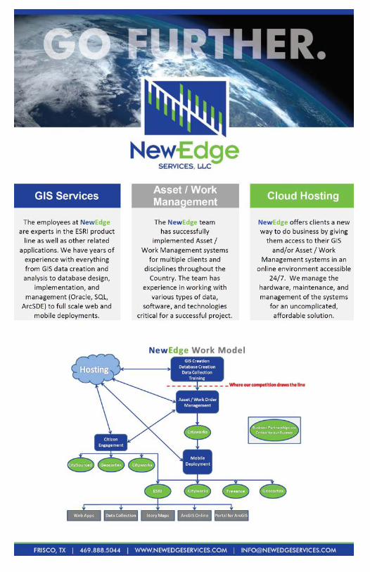
NewEdge Services, LLC is focused on implementing GIS, Asset/Work Management Systems, Cloud Hosting, and Related Services. NewEdge provides clients with turnkey solutions for a wide variety of needs and can provide additional resources for clients on specific projects. Our experience
demonstrates our abilities, which include:
• Database design, implementation, and management (Oracle, SQL, ArcSDE)
• Custom web and mobile applications • Hosted cloud solutions • GIS data creation • GIS analysis • Hard copy map/plan inventory, cataloging, and georeferencing • System integration • Asset/Work management system implementation and integration • Permitting system implementation and integration • User training and support • And much more… NewEdge has strategically aligned with multiple business partners to provide our clients with implementation services for products that are
53
leaders in their perspective fields. Our long standing business partner relationships include: Amazon Web Services, CitySourced, Cityworks, Esri, Freeance, and Geocortex by Latitude Geographics. The NewEdge team has all of the knowledge, experience and expertise needed to successfully implement all GIS related projects. Our team has been working together since 2008 and has over 100 years of combined experience in working with multiple types of data, software, and technologies that will be critical for a successful project.
Founded in 1962, The Schneider Corporation is a leading provider of geospatial and e-government solutions to hundreds of municipal, county, state, federal, and private entities. A technology leader, Schneider provides innovative, industry-leading
solutions to help organizations get the most from their limited resources, with creative product solutions such as Beacon™ and qPublic.net™ (local government information portals), Permitting™ (cloud-based permitting and work flow management), and IDAM™ (damage assessment software). Serving nearly 20% of the counties in the U.S., Schneider has a wide geographic footprint with several regional offices across the county. Schneider is a registered WBE and HUB.
United Geo Technologies, LLC, your geospatial service provider, offers a wide range of services such as photogrammetry, orthophotography,
parcel mapping, and geographic information systems. This small, woman owned business has extensive experience in the geospatial disciplines and our personnel include a Certified Photogrammetrist. UGT’s personnel have extensive experience in the following areas:

54
• Aerial Imagery Acquisition (both analog and digital) • Airborne GPS • Aerial Film Scanning • CAD (MicroStation and AutoCAD) • Contour Generation • Digital Aerial Triangulation • Digital Elevation Models (DEM) • Digital Terrain Models (DTM) • Digital Orthophotography (TIFF) • Image Compression (MrSID, JPEG2000, ECW) • LiDAR DTM and Contour Integration • Parcel Mapping • Geographic Information Services (ESRI) • Plan and Profile • Planimetric Feature Extraction • UAV / Drone Image Processing • Volume Computations
Headquartered in Norman, Oklahoma, U.S. Weather Decision Technologies, Inc. (WDT) provides organizations with weather analytics and decision
support on a global scale. The company utilizes big data solutions to develop and provide weather analytics such as hazardous weather detection and prediction, high resolution forecasts, decision analytics, content for mobile apps as well as interactive mapping. WDT employs the world-renowned WeatherOps forecast team, staffed by experts who provide global asset protection and commodities trading decision support. Be it asset protection, positioning of goods and services ahead of weather or as response to weather, or simply warning the general public of impending adverse weather, WDT has a product to fit any need.

55
NON-BOOTH SPONSORSHIPS
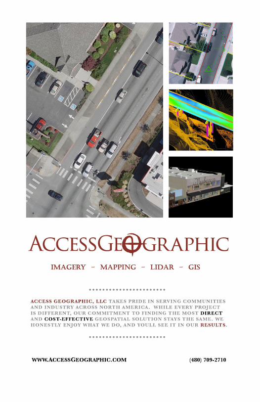
Access Geographic serves local government, industry and utilities across Oklahoma, Texas, Louisiana
and Mississippi by using innovative geospatial technologies without losing sight that care and detailed craftsmanship still drives quality results. The AGL team is passionate about working with geography, and is continually inspired to make it an accessible and useful resource through discipline, creativity and respect for our clients. From aerial mapping to terrestrial LiDAR, Access Geographic works hard to find a solid solution for your geospatial goals and delivers products that you can trust.
The GIS Certification Institute (GISCI) is a tax-exempt not-for-profit organization that provides the geographic information systems (GIS) community with an internationally-recognized, complete certification program. GISCI offers participants from the first early years on the job until retirement, a method of developing value for professionals and employers in the GIS profession. There are
currently over 8000 active GISPs located throughout the world. The current GISP Certification process consists of a Portfolio Application that describes an applicant's background in Ethics, Education, Experience, and Contributions to the Profession as well as the GISCI Geospatial Core Technical Knowledge Exam added in 2015. Selected GISPs performed groundbreaking work in the process of creating the Exam informed by both the Geospatial Technical Competency Model (GTCM) approved by the Department of Labor in 2010 and the GIS&T Body of Knowledge developed by UCGIS.

56
NOTES ____________________________________________________________________________________________________________________________________________________________________________________________________________________________________________________________________________________________________________________________________________________________________________________________________________________________________________________________________________________________________________________________________________________________________________________________________________________________________________________________________________________________________________________________________________________________________________________________________________________________________________________________________________________________________________________________________________________________________________________________________________________________________________________________________________________________________________________________________________________________________________________________________________________________________________________________________________________________________________________________________________________________________________________________________________________________________________________________________________________________________________________________________________________________________________________________________________________________________________________________________________________ ______________________________________________________

57
GISP CHECKLIST
Description
Clas
sific
atio
n
Cred
it
Rece
rtifi
catio
n Cr
edit
Cred
its E
arne
d
2½ Day 2016 SCAUG Conference (20 hour) Attendee (0.1 x # of days attended) EDU 0.25 3.33 Presenter (1 point per instance) CON 1 3 Poster Presenter (1 point per instance) CON 1 3 Poster Award Winner CON 2 6 1/2 Day Training (4 hour) (Training Certificate required for documentation credit.)
ArcGIS Tips & Tricks EDU 0.1 0.67 Editing & Maintaining Parcels with ArcMap EDU 0.1 0.67 1 Day Training Instructor : ________________________________ EDU 3 9
1 Day Training (8 hour) (Training Certificate required for documentation credit.)
Getting Answers & Solving Problems - An Intermediate Lesson in Spatial Analysis EDU 0.2 1.33
Editing Data Using ArcGIS for Desktop EDU 0.2 1.33 1 Day Training Instructor : ________________________________ EDU 3 9
2 Day Training (16 hour) (Training Certificate required for documentation credit.)
Introduction to ArcGIS Pro for GIS Professionals EDU 0.4 2.67 Image Analysis with ArcGIS EDU 0.4 2.67 Programming ArcGIS with Python EDU 0.4 2.67 2 Day Training Instructor : ________________________________ EDU 3 9
Total GISP Credits Earned

58
M
AP
BA
LLO
T
59
MA
P B
ALL
OT
Ple
ase
Vote
for
you
r Fa
vori
te M
ap
N
um
ber
of
Ma
p __
____
____
__
Tea
r O
ut
an
d T
urn
In
No L
ate
r Th
an
1:0
0pm
Th
urs
da
y, A
pril
21
st a
t R
egis
tra
tion