th 10c - california
TRANSCRIPT
STATE OF CALIFORNIA-THE RESOURCES AGENCY ,·.j
CALIFORNIA COASTAL COMMISSION SOUTH CENTRAL COAST AREA
89 SOUTH CALIFORNIA ST., SUITE 200
VENTURA, CA 93001
(805) 585 - 1800
Th 10c
."""""": _,r'""r ~-•. "'. :i'
;. ~. : •.. ,.,. ~.o. ,. ·• ...... ~- " .. ~· .· );; i "'' '·,,_.; f. ,,. ... --"' ~- :~, • .-i 'l':c_·~~ i' -~·
Filed: 1/19/03 49th Day: 3/09/02 180th Day: 7 /18/0_3~ Staff: LKF-V(/' Staff Report: 6/25/03 Hearing Date: 7/10/03 Commission Action:
STAFF REPORT: PERMIT AMENDMENT
APPLICATION NO.: 4-99-169-A1
APPLICANT: Alfredo and Robin Trento
GRAY DAVIS, Governor
PROJECT LOCATION: 25126 Pacific Coast Highway, City of Malibu (Los Angeles County)
DESCRIPTION OF PROJECT PREVIOUSLY APPROVED: Construction of a 6,706 sq. ft., 28ft. high, two-story single family residence; a 749 sq. ft., 18ft. high guest house; a 975 sq. ft., 18 ft. high detached garage; a 525 sq. ft., 14 ft. high detached garage; a pool; a driveway; a septic system; and a concrete v-ditch drainage swale system. The project also includes the construction of a 420 ft. long 3-6 ft. high retaining wall, a 120 ft. long 2-3 ft. high retaining wall, and approximately 3,802 cu. yds. of grading (1,302 cu. yds. of cut, 630 cu. yds. of fill, and 1,870 cu. yds. of removal and recompaction).
DESCRIPTION OF AMENDMENT: Construction of a 7,200 sq. ft. unlit tennis court; maximum six foot high, approximately 240 foot long retaining wall; six to twelve foot high, approximately 360 foot long chain link fence surrounding the tennis court; 640 cu. yds. of excavation to be exported outside of the coastal zone, and 800 cu. yds. of remedial grading (removal and recompaction).
LOCAL APPROVALS RECEIVED: Approval in Concept, City of Malibu Planning Department, December 12, 2002; Approval in Concept, City of Malibu Geology Review, August 29, 2002; Approval in Concept, City of Malibu Biological Review, September 23, 2002.
SUBSTANTIVE FILE DOCUMENTS: Coastal Development Permit No. 4-99-169; Letter "Re: Proposed tennis court development at the Dr. Trento Residence at 25126 Pacific Coast Highway, in the City of Malibu, CA 90265," by E. Gary Stickel, Ph.D., Consulting Archaeologist, Environmental Research Archaeologists - A Scientific Consortium, February 21, 2003; "Preliminary Geologic and Soils Engineering Investigation, Proposed Tennis Court, 25134 Pacific Coast Highway, Malibu, California," by GeoConcepts, Inc., October 22, 2002; Phase 2 (Test Phase) of Archaeological Site CA-LAN 803 Report by E. Gary Stickel, Ph.D., Consulting Archaeologist, Environmental Research Archaeologists - A Scientific Consortium, March 1999; Phase 3 (Mitigation) Program for Archaeological Site CA-LAN 803 Report by E. Gary Stickel, Ph.D., Consulting Archaeologist, Environmental Research Archaeologists - A Scientific Consortium, October 1999.

4-99-169-A1 (Trento) Page2
PROCEDURAL NOTE: The Commission's regulations provide for referral of permit amendment requests to the Commission if:
1) The Executive Director determines that the proposed amendment is a material change,
2) Objection is made to the Executive Director's determination of immateriality, or
3) The proposed amendment affects conditions required for the purpose of protecting a coastal resource or coastal access.
If the applicants or objector so requests, the Commission shall make an independent determination as to whether the proposed amendment is material (14 Cal. Code of Regulations Section 13166). In this case, the Executive Director has determined that the proposed amendment is a material change to the project and has the potential to affect previously imposed special conditions required for the purpose of protecting coastal resources.
SUMMARY OF STAFF RECOMMENDATION
Staff recommends denial of the applicants' proposal, including construction of a 7,200 sq. ft. unlit tennis court; maximum six foot high, approximately 240 foot long retaining wall; six to twelve foot high, approximately 360 foot long chain link fence surrounding the tennis court; 640 cu. yds. of excavation to be exported outside of the coastal zone, and 800 cu. yds. of remedial grading (removal and recompaction).
As details.d below, the proposed project is inconsistent with Malibu LCP polici3s for the protection of visual resources and cultural resources. Furthermore, feasible alternc.:tives exist that would be consistent with the resource protection policies of the Malibu LCP.
I. STAFF RECOMMENDATION
MOTION: I move that the Commission approve Coastal Development Permit Amendment No. 4-99-169-A1 for the development proposed by the applicants.
STAFF RECOMMENDATION OF DENIAL:
Staff recommends a NO vote. Failure of this motion will result in denial of the permit amendment and adoption of the following resolution and findings. The motion passes only by affirmative vote of a majority of the Commissioners present.
RESOLUTION TO DENY THE PERMIT AMENDMENT:
The Commission hereby denies a coastal development permit amendment for the proposed development on the ground that the development will not conform with the policies of the

4-99-169-A1 (Trento) Page3
City of Malibu Local Coastal Program (LCP). Approval of the permit amendment would not comply with the California Environmental Quality Act because there are feasible mitigation measures or alternatives that would substantially lessen the significant adverse impacts of the development on the environment.
II. FINDINGS AND DECLARATIONS
The Commission hereby finds and declares:
A. Project Description and Background
The applicants seek approval for construction of a 7,200 sq. ft. unlit tennis court; maximum six foot high, approximately 240 foot long retaining wall; six to twelve foot high, approximately 360 foot long chain link fence surrounding the tennis court; 640 cu. yds. of excavation to be exported outside of the coastal zone, and 800 cu. yds. of remedial grading (removal and recompaction). (Exhibits 4 - 7).
The project site is a 4.78-acre bluff top lot located near Pepperdine University in the City of Malibu (Exhibit 1). The site is located south of Pacific Coast Highway and north of Malibu Road. The gently sloping bluff top portion of the site is developed with a single family residence, two garages, guesthouse, pool, driveway, turnaround, retaining walls, and landscaping, approved by the Commission under Coastal Development Permit No. 4-99-169 (Exhibits 2, 3, and 10). The remainder of the property consists of the bluff face, which contains no development with the exception of a concrete v-ditch drainage system. The proposed tennis court is located between the existing development and the northern property line, adjacent to Pacific Coast Highway.
The proposed development is visible from Pacific Coast Highway, a designateu Scenic Road in the Malibu LCP (Exhibits 1 - 3). The site provides public views of the ocean between the guesthouse area and main residence, and on either side of the developed area of the site. In order to protect visual resources, Special Condition One (1) of the underlying permit prohibited all development from exceeding the 177 ft. elevation line in height, and required all fencing to be visually permeable (wrought iron or glass) and no more than six feet in height. The proposed tennis court extends from the western end of the guest house to the western end of the main residence, and thus is located within the view corridor between the two areas of development. The proposed chain link fencing for the tennis court extends to the 183 ft. elevation line, and is visually obtrusive.
Special Condition One (1) of the original permit also required deletion of a proposed 42 inch high masonry wall along the northern property line adjacent to Pacific Coast Highway, but allowed visually permeable fencing to be constructed in its place. Approved plans for the underlying permit indicated that a maximum six foot high, wrought iron fence, with ~ inch pickets spaced 6 inches apart, would be constructed along the northern property line. However, black chain link fencing currently extends along the length of the property, diminishing public views of the ocean across the site. The Commission's enforcement division will evaluate further actions to address this matter.

4-99-169-A1 {Trento) Page4
In addition, archaeological resources are present on the subject site (listed in the State of California Archive as Archaeological Site CA-LAN-803). Artifacts have been found in the proposed area of development (Exhibits 8 • 9).
B. Visual Resources
The Malibu LCP provides for the protection of scenic and visual resources, including views of the beach and ocean, views of mountains and canyons, and views of natural habitat areas. The LCP identifies Scenic Areas, which are those places on, along, within, or visible from scenic roads, trails, beaches, parklands and state waters that offer scenic vistas of the beach and ocean, coastline, mountains, canyons and other unique natural features, and that are not largely built out. The LCP policies require that new development not be visible from scenic roads or public viewing areas. Where this is not feasible, new development must minimize impacts through siting and design measures.
Section 30251 of the Coastal Act, which is incorporated as a policy of the Malibu LCP, states that:
The scenic and visual qualities of coastal areas shall be considered and protected as a resource of public importance. Permitted development shall be sited and designed to protect views to and along the ocean and scenic coastal areas, to minimize the alteration of natura/land forms, to be visually compatible with the character of surrounding areas, and, where feasible, to restore and enhance visual quality in visually degraded areas. New development in highly scenic areas such as those designated in the California Coastline Preservation and Recreation Plan prepared by the Department of Parks and Recreation and by local government shall be subordinated to the character of its setting.
In addition, the following LCP policies are applicable in this case:
6.1 The Santa Monica Mountains, including the City, contain scenic areas of regional and national importance. The scenic and visual qualities of these areas shall be protected and, where feasible, enhanced.
6.2 Places on and along public roads, trails, parklands, and beaches that offer scenic vistas are considered public viewing areas. Existing public roads where there are views of the ocean and other scenic areas are considered Scenic Roads. Public parklands and riding and hiking trails which contain public viewing areas are shown on the LUP Park Map. The LUP Public Access Map shows public beach parks and other beach areas accessible to the public that serve as public viewing areas.
6.4 Places on, along, within, or visible from scenic roads, trails, beaches, parklands and state waters that offer scenic vistas of the beach and ocean, coastline, mountains, canyons and other unique natural features are considered Scenic Areas. Scenic Areas do not include inland areas that are largely developed or built out such as residential subdivisions along the coastal terrace, residential development inland of Birdview A venue and Cliffside Drive on Point Dume, or existing commercial development within the Civic Center and along Pacific Coast Highway east of Malibu Canyon Road.
6.5 New development shall be sited and designed to minimize adverse impacts on scenic areas visible from scenic roads or public viewing areas to the maximum
4-99-169-A 1 (Trento) PageS
feasible extent. If there is no feasible building site location on the proposed project site where development would not be visible, then the development shall be sited and designed to minimize impacts on scenic areas visible from scenic highways or public viewing areas, through measures including, but not limited to, siting development in the least visible portion of the site, breaking up the mass of new structures, designing structures to blend into the natural hillside setting, restricting the building maximum size, reducing maximum height standards, clustering development, minimizing grading, incorporating landscape elements, and where appropriate, berming.
6.6 Avoidance of impacts to visual resources through site selection and design alternatives is the preferred method over landscape screening. Landscape screening, as mitigation of visual impacts shall not substitute for project alternatives including resiting, or reducing the height or bulk of structures.
6.9 All new development shall be sited and designed to minimize alteration of natura/landforms by:
• Conforming to the natural topography. • Preventing substantial grading or reconfiguration of the project site. • Eliminating flat building pads on slopes. Building pads on sloping
sites shall utilize split level or stepped-pad designs. • Requiring that man-made contours mimic the natural contours. • Ensuring that graded slopes blend with the existing terrain of the site
and surrounding area. . • Minimizing grading permitted outside of the building footprint. • Clustering structures to minimize site disturbance and to minimize
development area. • Minimizing height and length of cut and fill slopes. • Minimizing the height and length of retaining walls. • Cut and fill operations may be balanced on-site, whP.re the grading
does not substantially alter the existing topography and blends with the surrounding area. Export of cut material may be required to preserve the natural topography.
6.12 All new structures shall be sited and designed to minimize impacts to visual resources by:
• Ensuring visual compatibility with the character of surrounding areas. • Avoiding large cantilevers or understories. • Setting back higher elements of the structure toward the center or
uphill portion of the building.
6.13 New development in areas visible from scenic roads or public viewing areas, shall incorporate colors and exterior materials that are compatible with the surrounding landscape. The use of highly reflective materials shall be prohibited.
6.14 The height of permitted retaining walls shall not exceed six feet. Stepped or terraced retaining walls up to twelve feet in height, with planting in between, may be permitted. Where feasible, long continuous walls shall be broken into sections or shall include undulations to provide visual relief. Where feasible, retaining walls supporting a structure should be incorporated into the foundation system in a stepped or split level design. Retaining walls visible

4-99-169-A1 (Trento) Page6
from scenic highways, trails, parks, and beaches should incorporate veneers, texturing and/or colors that blend with the surrounding earth materials or landscape.
6. 15 Fences, walls, and landscaping shall not block views of scenic areas from scenic roads, parks, beaches, and other public viewing areas.
6.17 Where parcels on the ocean side of and fronting Pacific Coast Highway, Malibu Road, Broad Beach Road, Birdview A venue, or Cliffside Drive descend from the roadway, new development shall be sited and designed to preserve bluewater ocean views by:
• Allowing structures to extend no higher than the road grade adjacent to the project site, where feasible.
• Limiting structures to one story in height, if necessary, to ensure bluewater views are maintained over the entire site.
• Setting fences away from the road edge and limiting the height of fences or walls to no higher than adjacent road grade, with the exception of fences that are composed of visually permeable design and materials.
• Using native vegetation types with a maximum growth height and located such that landscaping will not extend above road grade.
6.18 For parcels on the ocean side of and fronting Pacific Coast Highway, Malibu Road, Broad Beach Road, Birdview Avenue, or Cliffside Drive where it is not feasible to design a structure located below road grade, new development shall provide a view corridor on the project site, that meets the following criteria:
• Buildings shall not occupy more than 80 percent maximum of the lineal frontage of the site.
• The remaining 20 percent of lineal frontage shall be maintained as one contiguous view corridor.
• No portion of any structure shall extend into the view corridor. • Any fencing across the view corridor shall be visually permeable and
any landscaping in this area shall include only /ow-growing species that will not obscure or block bluewater views.
• In the case of development that is proposed to include two or more parcels, a structure may occupy up to 100 percent of the lineal frontage of any parce/(s) provided that the development does not occupy more than 70 percent maximum of the total lineal frontage of the overall project site and that the remaining 30 percent is maintained as one contiguous view corridor.
The applicants seek approval for construction of a 7,200 sq. ft. unlit tennis court; maximum six foot high, approximately 240 foot long retaining wall; six to twelve foot high, approximately 360 foot long chain link fence surrounding the tennis court; 640 cu. yds. of excavation to be exported outside of the coastal zone, and 800 cu. yds. of remedial grading (removal and recompaction).
The project site is located immediately south of Pacific Coast Highway, in the vicinity of Pepperdine University. The proposed project is visible from Pacific Coast Highway, a designated Scenic Road. The site conforms to the definition, under Malibu LCP Policy 6.4, of a Scenic Area, in that it is visible from a scenic road that affords scenic vistas of the ocean. Therefore, this site is governed by LCP Policy 6.5, which requires that development minimize adverse impacts on scenic areas that are visible from scenic roads or public viewing areas.

4-99-169-A1 (Trento) Page 7
The Malibu LCP requires new development to be sited and designed to minimize adverse impacts on scenic areas, through measures such as siting development in the least visible portion of the site, clustering development, minimizing grading, providing view corridors, and blending structures into their natural settings. The Malibu LCP specifically requires fencing to be sited and designed to minimize visual impacts, through measures such as employing visually permeable design, limiting fence height to no higher than the adjacent road grade, and siting fences away from scenic roads.
The proposed tennis court is visible from Pacific Coast Highway and is located within existing ocean view corridors. The proposed court is to be dug into the gently descending slope between the existing developed area of the site and Pacific Coast Highway. The court is to be supported on three sides by a retaining wall, which will reach up to six feet in height on the court's upslope edge, and taper to finished grade (171 ft. asl) on either end. The proposed tennis court and retaining wall thus do not exceed the 177 ft. limit required by Special Condition One (1) of the underlying permit, although the retaining wall exceeds the road grade of Pacific Coast Highway by 2 feet, inconsistent with Policy 6.17 of the Malibu LCP. More significantly, the proposal also includes construction of a six foot high visually obtrusive chain link fence atop the retaining wall, thus raising the height of development to an elevation of 183 feet asl.
The Commission notes that the 177 ft. height limit in itself allows some blockage of horizon and bluewater views. Although 177 ft. is the approximate elevation of viewers passing by on Pacific Coast Highway, views are framed by a descending cone of vision, and thus structures further from the road that extend to the elevation of the viewer block views of the ocean beyond. This point was discussed at the April 12, 2000 Commission hearing on the original project.
In the staff report prepared for the hearing, staff recommended that no structure exceed 20 ft. in height from existing grade and the 175 ft. elevation line (the approximate elevation of Pacific Coast Highway). However, at the April 12, 2000 Commission hearing, the applicants argued that the wide view corridors between the proposed structures would mitigate view blockage caused by roof lines exceeding the recommended height limits. The Commission subsequently increased the allowed height limit to the 177 ft. elevation line. The proposed tennis court is located within the view corridors put forth as mitigation at the April 12, 2000 hearing.
Construction of the proposed project, particularly the chain link fence, would obscure the ocean view corridors between existing structures on the site, significantly diminishing bluewater views from Pacific Coast Highway, by adding a second line of fencing parallel to the visually permeable wrought iron fencing previously approved under COP No. 4-99-169. (As noted in Section A. above, an unpermitted chain link fence was constructed along the northern property line in lieu of the permitted fencing. This matter has been referred to Commission Enforcement staff.) Policy 6.15 of the Malibu LCP prohibits fencing from blocking views from scenic roads to scenic areas.
In addition, Policy 6.9 of the Malibu LCP requires structures to be clustered to minimize site disturbance and development area. The proposed tennis court extends development into a new area of the site and increases the already considerable development footprint by 7200

4-99-169-A1 (Trento) PageB
square feet. In summary, the project is inconsistent with the Malibu LCP's siting and design standards for protection of visual resources.
The applicants' representative has suggested alternatives to the proposed project, including eliminating the chain link fence around the tennis court, or replacing the chain link fence with retractable netting that would be used only when play was in session. Eliminating the chain link fence would reduce the visual impacts of the project, but would allow tennis balls to escape the court, potentially creating a hazard on adjacent Pacific Coast Highway. In addition, the practical difficulties of using a tennis court without fencing would invite a future violation in which fencing is erected around the court. Alternately, replacing the chain link fence with retractable netting would reduce visual impacts only when the netting was down, a circumstance that could not be regulated or monitored.
Feasible alternatives exist that would eliminate the visual impacts of the project. The existing swimming pool provides recreational use of the property, in addition to residential use provided by the remainder of the development. Moreover, the additional tennis court is not necessary to provide a reasonable use of the property. Therefore, use of the existing recreational facilities and elimination of the tennis court is a feasible alternative to the proposed project that would eliminate the visual impacts of the project.
Implementation of the "no construction" alternative would significantly reduce the visual impacts of the proposed project. Therefore, for the reasons discussed above, the Commission finds that the proposed development has not been sited or designed in a manner that would minimize adverse impacts to public views and is, therefore, not consistent with the Malibu LCP.
C. Archaeological Resources
The Malibu LCP provides for the protection of archaeological, historical, and paleontological resources. The Malibu LCP requires new development to avoid and minimize impacts to these resources, and requires mitigation measures be implemented when such impacts cannot be avoided.
Section 30244 of the Coastal Act, which is incorporated as part of the Malibu LCP, states:
Where development would adversely impact archaeological or paleontological resources as identified by the State Historic Preservation Officer, reasonable mitigation measures shall be required.
In addition, the following LCP policies for the protection of archaeological resources are applicable in this case:
5.60 New development shall protect and preserve archaeological, historical and paleontological resources from destruction, and shall avoid and minimize impacts to such resources.
5.61 Where development would adversely impact archaeological or paleontological resources as identified by the State Historic Preservation Officer, reasonable mitigation measures shall be required.

4-99-169-A 1 (Trento) Page9
5.63 Coastal Development Permits for new development within archaeologically sensitive areas shall be conditioned upon the implementation of the appropriate mitigation measures.
5.64 New development on sites identified as archaeologically sensitive shall include onsite monitoring of all grading, excavation and site preparation that involve earth moving operations by a qualified archaeologist(s) and appropriate Native American consultant(s).
The applicants seek approval for construction of a 7,200 sq. ft. unlit tennis court; maximum six foot high, approximately 240 foot long retaining wall; six to twelve foot high, approximately 360 foot long chain link fence surrounding the tennis court; 640 cu. yds. of excavation to be exported outside of the coastal zone, and 800 cu. yds. of remedial grading (removal and recompaction).
The project site is located immediately south of Pacific Coast Highway in central Malibu, in a region of the Santa Monica Mountains that contains one of the most significant concentrations of archaeological sites in southern California. A portion of Archaeological Site CA-LAN-803, as listed in the State of California Archives, is located on the subject site. The recorded map of CA-LAN-803 indicates that the archaeological site extends over almost the entire subject site, including the proposed location for the tennis court.
Several archaeological studies have been conducted on the project site. A mapping project conducted by Dr. Chester King and the National Park Service in 1998 located 626 artifacts on the surface, including manos, hammerstones, choppers, and a concentration of Pismo Clam shells. Several manos, hammerstones, choppers, and other artifacts were found within the footprint of the proposed tennis court.
A Phase II archaeological study was conducted by Dr. E. Gary Stickel in March 1999 prior to approval of COP No. 4-99-169. The study involved excavation of 31 shovel test pits and four 1 x 1 meter test pits located on different areas of the subject site. Shovel Test Pits 6 and 7 were excavated within the footprint of the proposed tennis court. These narrow pits yielded 27 debitage items related to tool production, including primary and secondary reduction flakes, thinning flakes, core fragments, and angular debris, but no tools. The study concluded that although some artifacts have been discovered on the subject site, CALAN-803 is not highly significant from an archaeological perspective.
The applicants have submitted a letter from Dr. Stickel regarding the proposed tennis court site. Dr. Stickel states:
The proposed tennis court area is between the existing guest house, garage and Pacific Coast Highway. That area was extensively sampled by our authoritative program. It was found to be the least sensitive of any area within the parcel regarding cultural resources. I have reviewed the proposed development (the tennis court and its associated grading and construction work) and I have concluded that it will not impact significant cultural resources.
Although Dr. Stickel states that the tennis court area is the least sensitive of any area on the parcel, the Phase II study he conducted found a high volume of artifacts in two Shovel Test Pits (STPs) excavated within the footprint of the proposed tennis court, in comparison to other STPs excavated on site. The study found 18 artifacts in STP 7, more than in any of
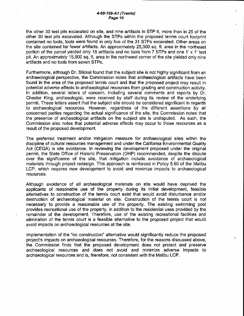
4-99-169-A1 (Trento) Page 10
the other 30 test pits excavated on site, and nine artifacts in STP 6, more than in 25 of the other 30 test pits excavated. Although the STPs within the proposed tennis court footprint contained no tools, tools were found in only five of the 31 STPs excavated. Other areas on the site contained far fewer artifacts. An approximately 25,000 sq. ft. area in the northeast portion of the parcel yielded only 18 artifacts and no tools from 7 STPs and one 1' x 1' test pit. An approximately 15,000 sq. ft. area in the northwest corner of the site yielded only nine artifacts and no tools from seven STPs.
Furthermore, although Dr. Stickel found that the subject site is not highly significant from an archaeological perspective, the Commission notes that archaeological artifacts have been found in the area of the proposed tennis court and that the proposed project may result in potential adverse effects to archaeological resources from grading and construction activity. In addition, several letters of concern, including several comments and reports by Dr. Chester King, archaeologist, were received by staff during its review of the underlying permit. These letters assert that the subject site should be considered significant in regards to archaeological resources. However, regardless of the different assertions by all concerned parties regarding the actual significance of the site, the Commission notes that the presence of archaeological artifacts on the subject site is undisputed. As such, the Commission also notes that potential adverse effects may occur to those resources as a result of the proposed development.
The preferred treatment and/or mitigation measure for archaeological sites within the discipline of cultural resources management and under the California Environmental Quality Act (CEQA) is site avoidance. In reviewing the development proposed under the original permit, the State Office of Historic Preservation (OHP) recommended, despite the dispute over the significance of the site, that mitigation include avoidance of archaeological materials through project redesign. This approach is reinforced in Policy 5.60 of the Malibu LCP, which requires new development to avoid and minimize impacts to archaeological resources.
Although avoidance of all archaeological materials on site would have deprived the applicants of reasonable use of the property during its initial development, feasible alternatives to construction of the tennis court exist that would avoid disturbance and/or destruction of archaeological material on site. Construction of the tennis court is not necessary to provide a reasonable use of the property. The existing swimming pool provides recreational use of the property, in addition to the residential uses provided by the remainder of the development. Therefore, use of the existing recreational facilities and elimination of the tennis court is a feasible alternative to the proposed project that would avoid impacts on archaeological resources at the site.
Implementation of the "no construction" alternative would significantly reduce the proposed project's impacts on archaeological resources. Therefore, for the reasons discussed above, the Commission finds that the proposed development does not protect and preserve archaeological resources and does not avoid and minimize adverse impacts to archaeological resources and is, therefore, not consistent with the Malibu LCP.

D. CEQA
4-99-169-A1 (Trento) Page 11
Section 13096(a) of the Commission's administrative regulations requires Commission approval of Coastal Development Permit application to be supported by a finding showing the application, as conditioned by any conditions of approval, to be consistent with any applicable requirements of the California Environmental Quality Act (CEQA). Section 21 080.5(d)(2)(A) of CEQA prohibits a proposed development from being approved if there are feasible alternatives or feasible mitigation measures available that would substantially lessen any significant adverse effect that the activity may have on the environment.
The Commission finds that the proposed project would result in significant adverse effects on the environment, within the meaning of the California Environmental Quality Act of 1970. Therefore, the proposed project is determined to be inconsistent with CEQA and the policies of the Coastal Act. As noted previously, feasible alternatives exist which would not result in the significant, avoidable adverse impacts to coastal resources and public coastal views of the applicants' proposed project.

...t: )> m
oc:::::: "tJ X -- \ "tJ :::c
0 r ~ 0 OJ
2:. ~ ~ =i - \
~ """ 0 z ~ z p
~ ~ z I 9 -~ -
..... ... \t!:.. •o
'"'
TR ·,
"'l'!l~ h-t,:?"\
0"1 L.; ·-.:.,;"., c ~. Jdl D
~~~~,---r~~-)- L-4----- l "
I "· ~t~ \,~~ \i;
\ i\ "" "t~)~'- :::
~~ to ~ (
tdu ,lj [~
;l\ j'<' IS! J' \ I il'i;,···, ::· ,\· ' '< er/'Ji'f': ;1:: 'l 1 TERHUNE ,<S, """' \ 'i ~~--~J." ;t~~ "~~! , .• ' ' \\ ! , \~;~/ 'r";; ..,;· I .,.) ... ~,, ;:Y ' ~ ~t. /'··k ~;._ -- __,. -- ~·~ .,, ~· ~ I l! j ' '· SANTA 'fiiCA MOUNTAINS /- !
' ' I I \ ! '
L
'• /~! ;/ l'<\
Project Site jj
\·, JJ~!!~NAL RE5RtATJON AR£41 '·l ~\-., / / -~~ ' ~: ./~;:·s r-::~~~::~~~-;~:~;>~ ~- ~ -~- O~o
'-..f .. c~~·orr ¥·-. ... ,\~:---'5t.,"io~ i lit>"'',.
~K , ··'" ~ .... ·--.., ... , :-;,., \ ?"~·.Lii~?i· :f:'i> \.( ;o;. / .
t...w~-~~~_,--F
?5
lw 'Q
~~~<·· 3(]''
! ~': ---, --'1~~ I
- - ,-.. j .:· \ i\ \ :l'®' . ;~
\"§ \
' I
~~ - ('\,Uf\;) I ~.. nn• -· -· . ~- <t.::.::::=--~'::!':~LQR-1 , • ror/:':.';,. ' ··-~ ••·• CiN •u . -b.reu •. ·/0!( 110
IF1C . . .. PU1Rc'O , .. • :::-::--.£_ __ .;__ ____ · .. _::::.::_~=·.:::_· ..... ~_:~:::_.:_~; 8f~H ••
'-·L" . . <( · .-.:,··. // · I ~ I !
i
\
30

I T I :r>T.;" ~ -t:. ""0 X
~ \ ;:g ::J:
~ ~ 0 OJ ~ ~ =i
\ -s -..... 0 z
cs--. z p
[ ~ z
~ 9 ~
LLJ I I
Site of proposed
tennis court
Base photo - Copyright (C) 2002 Kenneth Adelman, California Coastal Records Project, www.californiacoastline.org

~t ~ -(\ ~ \ -..... ~{\' .J.\ I
~~ \' -.;,...
~ ~ ""C :I: r -0 IJJ ~ =i 0 z z 0 z . 9l>.:\
Site of' proposed
tennis court
Base photo- Copyright (C) 2002 Kenneth Adelman, California Coastal Records Project, www.californiacoastline.org

(._) I - i
~ :
-. i .._,
i I
'-! I
.::.J
. "\;-
-"" .;(f-"'
:;-, -,' ' :.:...,
-~ ,_. ,_ >
' l ~..1. __ .. ,
I I
IIi·! I ,'\\ '
/''
::r:, ~ '
I',' I-
.J '"'~-;.'~! 7
0
"
EXHIBIT NO. L/ APPLICATION NO.
Strr: PLAN

, I ', ~
I I l
I I ' I
EXHIBIT NO. '5 APPLICATION NO.

/ -". . ...L....-
(1';9)< ~IW\1) ·---·--··----··
\ '';";\X ------ - -----
\I 7o 1) '------------/76----~
~
(I'~C~
~ ~
--..._
""'
G'-. -t: ~..b c:t ~ - \ ?.. 13'
-
\.
\. \.
~
--~-
0 l{)
(17~ /!A.\: ("0<2:~-- -I ···•
(\;..-;')\-
"
175.00 FL
·--.... ~><-
A
j\. ---171.50TW 170.40FS ~·-l .. >'
---
/
l{) n
=0.5!':
S8T26'09"E
.., >r)
ci
~
't\1!.7)
.. ,
TENNIS COURT ,,,,, FS==171.00 .
7,!
CD
'-/ -/
Go•:O!- 170-------1\IL) ).,
----------
---:..,.
:t,-:: "\
,,:; -·· _,,., ._r,l ....
. . -H,\' . -
( \74 (i) ~
. ·--~-(17,1, ti-·
PACIFIC COAST HIGHWAY -(/If. f 1 /,·:'IW)
A "' - ~_j_
... ------- ~
··,•,)
--------·- (11'>61AG) ---------·----· u..LLLL/.LL --------------------r,7&-oi\
j -;(171 0)
I (li70) )( {1755) -~
175.50 n.
~--~- ~-
~ -------
~--/ ~,(1728) :::::::::
// (17l0i.-~ ~ A / ~/~---
j -y~ / :::~----------_p ~<~/----- ,(1706) ------· ~~~=/---- ~ .1} l",''· i) , __ ./·-" .
159.5JTG) 158.53/NV
(16117TW)
tl ~~:~······· ':t:,',4STW'i
\1~-~ ~~--~+~' -- -- -- --- --- - -
_i.

:....L.L:...J.. (175.7l.ACi {F560AC}
-----.... (176.2) (17•}0) ..
__ /'\ ---- -. (1741);~--- ------',
j /.------ (P2ol'
,,.~/ / //' // / ' /,:::
<m•Jv ~/ /__.-----~ _......-·
"\--~ ______ ... ............-\1- ! --------- __ ..-/··
/............- I ,..-- / .... ·~ . I _.-/ ,...-~! ~-- -------~112 ~ --~ ~(1671)•_..-
~~ ,11108) /"/ .- ,/' //
- I _....... // / 11\ ~---- // ------ t= ----- ~ ,,, ~~ ,,a /_ If) ~:Q~ =---=====~----/- __ / ~
~ )>
~ ...t::. "'0 "'0 I r-- ~ 0
~ ~ ~ I
l .......... 5 ~ z ~ z \ 9
i ~
m X J: tD =i z p ~
655 /'" 0 / .- Vl ~~:g\ / __ ./ -------- ______ _....... ~ -----'--- ~ ,/ ----(15•}4:.'C0)---.__.,....... -"/
~\1~~1)9Fl) •(~52~.~ . ·\----~_/ __ . .--
{161.11Tw) ~ \ \ ~ ~ \ ;-(150_~!.~ ~I ~ \
\\~----~ \\ ·{1'>~3)
{ll'<i..''',<.:·~ ~!'~.?·Hfl)
~~~
..... ----
CONSTRUCTION NOTES: (])-CONSTRUCT SURIAC[ PrR SOILS RFPORT AND ARCHITECTS PLAN
~CONSTRUCT CONCRU£ CURB PER DETAIL HEREON ~(J)-CONSTRUCT CONCReTE SWALE AT WALL PER DETAIL HEREON r.-.:::::-F?UAINING WALL P[R srPERAT£ PERMIT \V@-INSTALL 24" CATCH BASIN PER NOS PRODUCTS OR EQUAL t?\::::- 6" DIA SCH£0 40 PVC PIPE @ I% MIN \V(j)- TIE INTO EXISTING ORA/NAG£ SYSTEM
NOTE: PROVIDE EXPANSION JOINT AT 40' -o• O.C. MAXIMUM WITH 1 /2" SATURATED FELT EXPANSION JOINT FILLER AND TOOLED JOINT AT 10'-o· O.C.
1 /2" RADIUS-T'l'!'.
6• CURB FACE BATTER 3:12
----------
lJ L. P r.;
~~/~)i•r',--.
PROPOSED GUTTER
G N --:=:)--r-r..,.. ... -\.. ... , ,~
l,'-"\.., .J) ...._ ...... ~ ...
........ --·
l-1--l.c----l '-'
0 :;;; ( EX. GRD.)\_ :- ~:::J
,_... ..-- 1-<(
Vl ~:;:: w
_PROP~OCS ~]
WALL A All WAll c; RFOliiRF A SFPARATE PERMIT
·.., ·'
RE1AINING WALL PER SEPARAl[ PERMIT
CONCRETE CURB @
// /~ CONCRETE SWALE
COIAPACTED SUBGRADE PER SOILS ENGR.
0
ol{ ~~
a
>=5 <(( a: (!)l
~0:: co 8Q ~:::> ~<( g:Q
0 1-z w 0:: 1-
z CD G Q:
c 2 <l
a::: c 0 u... c
u 0 w 0 a::: u <( -0... <
w 0 a::: 0... (
z -<(
-0.
~ -

.
Figure 4: Distribution of Mapped Artifacts. (Source: King 1997)
Figure 2: Distribution of mapped artifact locations
175.7 X
Approximate location of
proposed tennis court

• )
X r-
• \,{) r-
. \.0 r-
x

~ 175.0
A
175.7 X
Approximate location of
proposed tennis court
IE

B
X 175.0 Approximate
location of proposed tennis
court
- - - /"'
Figure 5: Distribution of artifacts less manos, hammerstones, t1aking hammerstones, and·'choppers.

~ T l> T m
c... ~ "'0 ><
~ ~ :I:
~ ~ 0 OJ
~ ~ ~
I 5 ~
z ~
z 0 ~ ~ z .
~i 9 ~
I J I - -
:.::::-:~::-: >~"-- '/- . -·- 'i ::.:;:.~.;}' .tt'l•
"'\/,/'
\. ··- '·
lk'' ·® !;; tr· I q 6' I' '·- '" \r', -· "!,•, N r'26'09. W \.; ·''" .,./"/ <./ 4 )" 22' ,.--• )'""- • avl \'[ j- \9 -- 5 ,,~,";;H.!£::::. ' . ' • I -· +- _. 4 .a: . ' TP-32.~· I SO'I1~ •
t;uSf A( [1f}(\l TO R(i,.L4,;f,_ ,..,., •• /
Ke.y: •-3oc:vt ST? 9, 1?~9~~·3o') ·-~OCM ::>"'P ..SGAC~-
.• 11:--AA~~·~r-il--. lit' • N •··- :t~1'
STP-6 ~r~·"' ~ ~- -l-
B : / ...
,./' ~~ / ....- /.
_/-:,.- ' '9
' '~.:sJ I II /
(/I''"/''" \ /
.~
\
.~-.·.
01 )~ ::;1"' .. /!Jf"' -~/ .
----- ~ \
\
Selected Phase II Survey Results: Area A- approximately 15,000 sq. ft.- 9 artifacts found;
Area B- proposed 7,200 sq. ft. tennis court footprint- 27 artifacts found
Area C- approximately 25,000 sq. ft.- 18 artifacts and 1 tool found
Tu 25b STATE OF CALIFORNIA- THE RESOURCES AGENCY GRAY DAVIS, Governor =================================================================~~~~~ CALIFORNIA COASTAL COMMISSION
Filed: 12/14/99 ~ 49th Day: N/A · 180th Day: N/A
SOUTH CENTRAL COAST AREA
89 SOUTH CALIFORNIA ST., SUITE 200
VENTURA, CA 93001
(805) 641.0142 Staff: S. Hudson Ob!f Staff Report: 5/25/00 Hearing Date: 6/13/00 Commission Action:
STAFF REPORT: REGULAR CALENDAR Revised Findings
APPLICATION NO.: 4-99-169
APPLICANT: Alfredo and Robin Trento AGENTS: Jaime Harnish Michael Andersson Susan McCabe
PROJECT LOCATION: 25126 Pacific Coast Highway, Malibu; Los Angeles County
COMMISISON DECISION: Approved with Ten (10) Special Conditions
DATE OF COMMISSION ACTION: April12, 2000 in Long Beach
COMMISSIONERS ON PREVAILING SIDE: Commissioners Daniels, Desser, Dettloff, Estolano, Hart, Kruer, McClain-Hill, Potter, Reilly, Wooley, and Wan.
PROJECT DESCRIPTION: Construction of a 6,706 sq. ft., 28ft. high, two-story single family residence; a 749 sq. ft., 18ft. high guest house; a 975 sq. ft., 18ft. high detached garage; a 525 sq. ft., 14ft. high detached garage; a pool; a driveway; a septic system; and a concrete v-ditch drainage swale system. The project also includes the construction of a 420 ft. long 3-6 ft. high retaining wall, a 120 ft. long 2-3 ft. high retaining wall, and approximately 3,802 cu. yds. of grading (1 ,302 cu. yds. of cut, 630 cu. yds. of fill, and 1,870 cu. yds. of removal and recompaction).
LOCAL APPROVALS RECEIVED: Approval in Concept City of Malibu Planning Department, Approval in Concept for City of Malibu Engineering and Geotechnical Review, Approval in Concept City of Malibu Environmental Health Department (Septic).
SUMMARY OF STAFF RECOMMENDATION
Staff recommends that the Commission adopt the following revised findings in support of the Commission's decision on April 12, 2000, to approve the proposed project subject to ten (1 0) special conditions as indicated on pages 4-9 of the staff report. The Commission found that the proposed project is consistent with the applicable Chapter Three policies of the Coastal Act.
Because Special Condition One was modified and Special Condition Ten was added during the public hearing, revised findings are necessary to reflect the action taken by the Commission. Staff recommends, therefore, that the Commission adopt the following resolution and revised findings in support of its action to approve this permit with conditions. Comments from the public concerning the findings will be limited to discussion of whether the findings reflect the action of the Commission.
EXHIBIT NO. /0 APPLICATION NO.

4-99-169 (Trento) Page2
SUBSTANTIVE FILE DOCUMENTS: Geologic and Soils Engineering Investigation Addendum by GeoConcepts, Inc. dated 3/10/00; Drainage System Response Letter by Land Design Consultants dated 2/1/00; Geologic and Soils Engineering Investigation Addendum by GeoConcepts, Inc. dated 1/31/00; Geologic and Soils Engineering Investigation Addendum by GeoConcepts, Inc. dated 10/25/99; Geologic and Soils Engineering Investigation Addendum by GeoConcepts, Inc. dated 9/17/99; Geologic and Soils Engineering Investigation Addendum by GeoConcepts, Inc. dated 9/1/99; Supplemental Geologic and Soils Engineering Report by GeoConcepts, Inc. dated 3/19/99; Supplemental Geologic and Soils Engineering Report by GeoConcepts, Inc. dated 7/10/98; Supplemental Geologic and Soils Engineering Report by GeoConcepts, Inc. dated 3/23/98; Limited Geologic and Soils Engineering Investigation Report by GeoConcepts, Inc. dated 1 0/23/97; Response Letter Regarding Phase Ill Mitigation Program by E. Gary Stickel, Ph.D. dated 6/3/99; Phase 2 (Test Phase) of Archaeological Site CA-LAN 803 Report by E. Gary Stickel, Ph.D. dated March 1999; Proposed Program for Test Phase (Phase 2) Archaeological Evaluation Report by E. Gary Stickel, Ph.D. dated 11/25/97: Coastal Development Permits (COPs) 4-98-142, 143, & 163 (Duggan & Levinson), COP 4-97-031 (Anvil). COP 5-90-020 (Young).
I. STAFF RECOMMENDATION
MOTION: I move that the Commission adopt the revised findings in support of the Commission's action on April 12, 2000, concerning approval of Coastal Development Permit 4-99-169.
STAFF RECOMMENDATION OF APPROVAL:
Staff recommends a YES vote on the motion. Passage of this motion will result in the adoption of revised findings as set forth in this staff report. The motion requires a majority vote of the members from the prevailing side present at the April 12, 2000, hearing, with at least three of the prevailing members voting. Only those Commissioners on the prevailing side of the Commission's action are eligible to vote on the revised findings.
RESOLUTION TO ADOPT REVISED FINDINGS:
The Commission hereby adopts the findings set forth below for approval of Coastal Development Permit 4-99-169 on the ground that the findings support the Commission's decision made on April 12, 2000, and accurately reflect the reasons for it.
II. Standard Conditions
1. Notice of Receipt and Acknowledgment. The permit is not valid and development shall not commence until a copy of the permit, signed by the permittee or authorized agent, acknowledging receipt of the permit and acceptance of the terms and conditions, is returned to the Commission office.
2. Expiration. If development has not commenced, the permit will expire two years from the date on which the Commission voted on the application. Development shall be pursued in a diligent manner and completed in a reasonable period of time. Application for extension of the permit must be made prior to the expiration date.

4-99-169 (Trento) Page3
3. Compliance. All development must occur in strict compliance with the proposal as set forth below. Any deviation from the approved plans must be reviewed and approved by the staff and may require Commission approval.
4. Interpretation. Any questions of intent or interpretation of any term or condition will be resolved by the Executive Director or the Commission.
5. Inspections. The Commission staff shall be allowed to inspect the site and the development during construction, subject to 24-hour advance notice.
6. Assignment. The permit may be assigned to any qualified person, provided assignee files with the Commission an affidavit accepting all terms and conditions of the permit.
7. Terms and Conditions Run with the Land. These terms and conditions shall be perpetual, and it is the intention of the Commission and the permittee to bind all future owners and possessors of the subject property to the terms and conditions.
Ill. Special Conditions
1. Revised Plans
Prior to issuance of the coastal development permit, the applicant shall submit, for the review and approval of the Executive Director, revised project plans which show that:
(a) No development shall exceed the 177 ft. elevation line in height. Any substantial changes to the footprint of the proposed structures will require an amendment to this permit.
(b) The proposed driveway, including all associated grading and fill slopes, is located no less than 25 ft. from the seaward most top edge of the bluff.
(c) The proposed 42 inch high masonry wall adjacent to Pacific Coast Highway is deleted. Fencing consisting of visually permeable designs and materials (e.g. wrought iron or non-tinted glass material) and low-lying vegetation consistent with Special Condition Two (2) shall be allowed. Fencing on site shall be limited to no more than 6 ft. in height. All bars, beams, or other non-visually permeable materials used in the construction of the proposed fence shall be no more than 1 inch in thickness/width and shall be placed no less than 12 inches in distance apart. Alternative designs may be allowed only if the Executive Director determines that such designs are consistent with the intent of this condition and serve to minimize adverse effects to public views.
(d) The proposed swimming pool is designed as a free-standing structure (walls do not rely upon the lateral support of the soil) set below grade.

4-99-169 (Trento) Page4
2. Landscape and Erosion Control Plans
Prior to issuance of a coastal development permit, the applicant shall submit a landscaping and erosion control plan, prepared by a licensed landscape architect or a qualified resource specialist, for review and approval by the Executive Director. The landscaping plan shall identify all necessary irrigation improvements. The landscaping and erosion control plan shall be reviewed and approved by the consulting engineering geologist to ensure that the plans are in conformance with the consultants' recommendations. The plans shall identify the species, extent, and location of all plant materials and shall incorporate the following criteria:
A) Landscaping Plan
1) All graded & disturbed areas on the subject site shall be planted and maintained for erosion control purposes within (60) days of receipt of the certificate of occupancy for the residence. To minimize the need for irrigation all landscaping shall consist primarily of native/drought resistant plants as listed by the California Native Plant Society, Santa Monica Mountains Chapter, in their document entitled Recommended List of Plants for Landscaping in the Santa Monica Mountains, dated October 4, 1994. Invasive, nonindigenous plan species which tend to supplant native species shall not be used.
2) All cut and fill slopes shall be stabilized with planting at the completion of final grading. Planting should be of native plant species indigenous to the Santa Monica Mountains using accepted planting procedures, consistent with fire safety requirements. Such planting shall be adequate to provide 90 percent coverage within two (2) years, and this requirement shall apply to all disturbed soils;
3) Plantings will be maintained in good growing condition throughout the life of the project and, whenever necessary, shall be replaced with new plant materials to ensure continued compliance with applicable landscape requirements;
4) The Permittee shall undertake development in accordance with the final approved plan. Any proposed changes to the approved final plan shall be reported to the Executive Dir~ctor. No changes to the approved final plan shall occur without a Coastal Commission - approved amendment to the coastal development permit, unless the Executive Director determines that no amendment is required.
5) Permanent irrigation improvements shall be designed to m1mm1ze groundwater infiltration and shall be primarily limited to drip irrigation systems. No permanent irrigation shall be allowed within 25 ft. of the landward edge of the top of the bluff or on the bluff slope itself.
6) Vegetation on the subject site shall be limited to low-lying species that will not block or adversely impact public views of the ocean from the highway. Vegetation within Zone A, as shown on Exhibit 4, shall be limited to no more than 2 ft. in height. Vegetation within Zone B, as shown on Exhibit 4b, shall be limited to no more than 14ft. in height. In no

4-99-169 (Trento) PageS
case shall vegetation on the subject site exceed the 175 ft. elevation line in height (approximate elevation of Pacific Coast Highway). The use of any vegetation of greater height than otherwise provided for above may be allowed only if the Executive Director determines that such landscaping is consistent with the intent of this condition and will serve to minimize adverse effects to public views.
7) Vegetation within 50 feet of the proposed house may be removed to mineral earth, vegetation within a 200 foot radius of the main structure may be selectively thinned in order to reduce fire hazard. However, such thinning shall only occur in accordance with an approved long-term fuel modification plan submitted pursuant to this special condition. The fuel modification plan shall include details regarding the types, sizes and location of plant materials to be removed, and how often thinning is to occur. In addition, the applicant shall submit evidence that the fuel modification plan has been reviewed and approved by the Forestry Department of Los Angeles County. Irrigated lawn, turf and ground cover planted within the fifty foot radius of the proposed house shall be selected from the most drought tolerant species or subspecies, or varieties suited to the Mediterranean climate of the Santa Monica Mountains.
B) Interim Erosion Control Plan
1) The plan shall delineate the areas to be disturbed by grading or construction activities and shall include any temporary access roads, staging areas and stockpile areas. The natural areas on the site shall be clearly delineated on the project site with fencing or survey flags.
2) The plan shall specify that should grading take place during the rainy season (November 1 - March 31) the applicant shall install or construct temporary sediment basins (including debris basins, desilting basins or silt traps), temporary drains and swales, sand bag barriers, silt fencing, stabilize any stockpiled fill with geofabric covers or other appropriate cover, install geotextiles or mats on all cut or fill slopes and close and stabilize open trenches as soon as possible. These erosion measures shall be required on the project site prior to or concurrent with the initial grading operations and maintained through out the development process to minimize erosion and sediment from runoff waters during construction. All sediment should be retained on-site unless removed to an appropriate approved dumping location either outside the coastal zone or to a site within the coastal zone permitted to receive fill.
3) The plan shall also include temporary erosion control measures should grading or site preparation cease for a period of more than 30 days, including but not limited to: stabilization of all stockpiled fill, access roads, disturbed soils and cut and fill slopes with geotextiles and/or mats, sand bag barriers, silt fencing; temporary drains and swales and sediment basins. The plans shall also specify that all disturbed areas shall be seeded with native grass species and include the technical specifications for seeding the disturbed areas. These temporary erosion control measures shall be monitored and maintained until grading or construction operations resume.

C) Monitoring.
4-99-169 (Trento) Page 6
Five years from the date of the receipt of the Certificate of Occupancy for the residence the applicant shall submit for the review and approval of the Executive Director, a landscape monitoring report, prepared by a licensed Landscape Architect or qualified Resource Specialist, that certifi~?S the on-site landscaping is in conformance with the landscape plan approved pursuant to this Special Condition. The monitoring report shall include photographic documentation of plant species and plant coverage.
If the landscape monitoring report indicates the landscaping is not in conformance with or has failed to meet the performance standards specified in the landscaping plan approved pursuant to this permit, the applicant, or successors in interest, shall submit a revised or supplemental landscape plan for the review and approval of the Executive Director. The revised landscaping plan must be prepared by a licensed Landscape Architect or a qualified Resource Specialist and shall specify measures to remediate those portions of the original plan that have failed or are not in conformance with the original approved plan.
3. Removal of Natural Vegetation
Removal of natural vegetation for the purpose of fuel modification within the 50 foot zone surrounding the proposed structure(s) shall not commence until the local government has issued a building or grading permit for the development approved pursuant to this permit. Vegetation thinning within the 50-200 foot fuel modification zone shall not occur until commencement of construction of the structure(s) approved pursuant to this permit
4. Archaeological Resources
By acceptance of this permit, the applicant agrees to have a qualified archaeologist(s) and appropriate Native American consultant(s) present on-site during all grading, excavation, site preparation, installation of irrigation systems or landscaping features that involve any earth moving operations. The number of monitors shall be adequate to observe the earth moving activities of each piece of active earth moving equipment. Specifically, the earth moving operations on the project site shall be controlled and monitored by the archaeologist(s) with the purpose of locating, recording and collecting any archaeological materials. In the event that any significant archaeological resources are discovered during operations, grading work in this area shall be halted and an appropriate data recovery strategy be developed, subject to review and approval of the Executive Director, by the applicant's archaeologist, the City of Malibu archaeologist and the native American consultant consistent with CEQA guidelines.

4-99-169 (Trento) Page7
5. Plans Conforming to Geologic Recommendation
All recommendations contained in the Geologic and Soils Engineering Investigation Addendum by GeoConcepts, Inc. dated 3/1 0/00; Drainage System Response Letter by Land Design Consultants dated 2/1/00; Geologic and Soils Engineering Investigation Addendum by GeoConcepts, Inc. dated 1/31/00; Geologic and Soils Engineering Investigation Addendum by GeoConcepts, Inc. dated 1 0/25/99; Geologic and Soils Engineering Investigation Addendum by GeoConcepts, Inc. dated 9/17/99; Geologic and Soils Engineering Investigation Addendum by GeoConcepts, Inc. dated 9/1/99; Supplemental Geologic and Soils Engineering Report by GeoConcepts, Inc. dated 3/19/99; Supplemental Geologic and Soils Engineering Report by GeoConcepts, Inc. dated 7/10/98; Supplemental Geologic and Soils Engineering Report by GeoConcepts, Inc. dated 3/23/98; and the Limited Geologic and Soils Engineering Investigation Report by GeoConcepts, Inc. dated 10/23/97. shall be incorporated into all final design and construction including all grading, septic, and drainage improvements. All plans must be reviewed and approved by the geologic and the geotechnical engineering consultants as conforming to said recommendations. Prior to the issuance of the coastal development permit, the applicant shall submit, for review and approval by the Executive Director, evidence of the consultants' review and approval of all project plans.
The final plans approved by the consultants shall be in substantial conformance with the plans approved by the Commission relative to construction, grading and drainage.
. Any substantial changes to the proposed development approved by the Commission which may be recommended by the consultants shall require an amendment to the permit or a new coastal permit.
6. Drainage and Polluted Runoff Control Plan and Maintenance Responsibility
Prior to the issuance of the Coastal Development Permit, the applicant shall submit for the review and approval of the Executive Director, a drainage and polluted runoff control plan designed by a licensed engineer which minimizes the volume, velocity and pollutant load of stormwater leaving the developed site. The plan shall be reviewed and approved by the consulting engineering geologist to ensure the plan is in conformance with the geologists' recommendations. The plan shall include but not be limited to the following criteria:
(a) The proposed concrete v-ditch drainage system to be constructed on the bluff face shall be of an earthtone color similar to the soil of the surrounding bluff slope. White tones shall not be acceptable.
(b) Post-development peak runoff rates and average volumes shall not exceed predevelopment conditions.
(c) Runoff from all roofs, parking areas, driveways and other impervious surfaces shall be collected and directed through a system of vegetated and/or gravel filter strips or other media filter devices. The filter elements shall be designed to 1) trap sediment,
4-99-169 (Trento) PageB
particulates and other solids and 2) remove or mitigate contaminants through infiltration and/or biological uptake. The drainage system shall also be designed to convey and discharge runoff in excess of this standard from the building site in nonerosive manner.
(d) The plan shall include provisions for maintaining the drainage and filtration systems so that they are functional throughout the life of the approved development. Such maintenance shall include the following: (1) the drainage and filtration system shall be inspected, cleaned and repaired prior to the onset of the storm season, no later than September 30th each year and (2) should any of the project's surface or subsurface drainage/filtration structures fail or result in increased erosion, the applicant/landowner or successor-in-interest shall be responsible for any necessary repairs to the drainage/filtration system and restoration of the eroded area. Should repairs or restoration become necessary, prior to the commencement of such repair or restoration work, the applicant shall submit a repair and restoration plan to the Executive Director to determine if an amendment or new coastal development permit is required to authorize such work.
7. Removal of Excavated Material
Prior to the issuance of the coastal development permit, the applicant shall provide evidence to the Executive Director of the location of the disposal site for all excavated material from the site. Should the dump site be located in the Coastal Zone, a coastal development permit shall be required.
8. Future Development Deed Restriction
A. This permit is only for the development described in coastal development permit No. 4-99-169. Pursuant to Title 14 California Code of Regulations Section 13250(b)(6), the exemptions otherwise provided in Public Resources Code Section 3061 O(a) shall not apply to the proposed residence or the entire subject parcel. Accordingly, any new development on the subject parcel or future improvements to the permitted single family residence, guesthouse, or garages, including but not limited to landscaping or repair and maintenance identified as requiring a permit in Public Resources Section 30610(d) and Title 14 California Code of Regulations Sections 13252(a)-(b}, shall require an amendment to Permit 4-99-169 from the Commission or shall require an additional coastal development permit from the Commission or from the applicable certified local government.
B. PRIOR TO ISSUANCE OF THE COASTAL DEVELOPMENT PERMIT, the applicant shall execute and record a deed restriction, in a form and content acceptable to the Executive Director, which reflects the above restrictions on development in the deed restriction and shall include legal descriptions of the applicant's entire parcel. The deed restriction shall run with the land, binding all successors and assigns, and shall be recorded free of prior liens that the Executive Director determines may affect the

4-99-169 (Trento) Page9
enforceability of the restriction. This deed restriction shall not be removed or changed without a Commission amendment to this coastal development permit.
9. Assumption of Risk, Waiver of Liability and Indemnity
A By acceptance of this permit, the applicant acknowledges and agrees (i) that the site may be subject to hazards from landslide, erosion, and wildfire; (ii) to assume the risks to the applicant and the property that is the subject of this permit of injury and damage from such hazards in connection with this permitted development; (iii) to unconditionally waive any claim of damage or liability against the Commission, its officers, agents, and employees for injury or damage from such hazards; and (iv) to indemnify and hold harmless the Commission, its officers, agents, and employees with respect to the Commission's approval of the project against any and all liability, claims, demands, damages, costs (including costs and fees incurred in defense of such claims), expenses, and amounts paid in settlement arising from any injury or damage due to such hazards.
B. PRIOR TO ISSUANCE OF THE COASTAL DEVELOPMENT PERMIT, the applicant shall execute and record a deed restriction, in a form and content acceptable to the Executive Director incorporating all of the above terms of this condition. The deed restriction shall include a legal description of the applicant's entire parcel. The deed restriction shall run with the land, binding all successors and assigns, and shall be recorded free of prior liens that the Executive Director determines may affect the enforceability of the restriction. This deed restriction shall not be removed or changed without a Commission amendment to this coastal development permit.
10. No Future Subdivision Deed Restriction
· A. In order to implement the applicant's proposal, the applicant agrees, on behalf of himself and all successors and assigns, that 1) the subject site may not be subdivided at any future point in time and 2) prior to issuance of the coastal development permit, a deed restriction will be recorded imposing this restriction.
B. PRIOR TO ISSUANCE OF THE COASTAL DEVELOPMENT PERMIT, the applicant shall execute and record a deed restriction, in a form and content acceptable to the Executive Director, which reflects the above restriction regarding no future subdivision of the subject site and shall include legal descriptions of the applicant's entire parcel. The deed restriction shall run with the land, binding all successors and assigns, and shall be recorded free of prior liens that the Executive Director determines may affect the enforceability of the restriction. This deed restriction shall not be removed or changed without a Commission amendment to this coastal development permit.

4-99-169 (Trento) Page 10
IV. Findings and Declarations
The Commission hereby finds and declares:
A. Project Description and Background
The applicant is proposing the construction of a 6,706 sq. ft., 28 ft. high, two-story single family residence; a 749 sq. ft., 18ft. high guest house; a 975 sq. ft., 18ft. high detached garage; a 525 sq. ft., 14ft. high detached garage; a pool; a driveway; a septic system; and a concrete v-ditch drainage swale system. The project also includes the construction of a 420 ft. long 3-6 ft. high retaining wall, a 120 ft. long 2-3 ft. high retaining wall, and approximately 3,802 cu. yds. of grading (1 ,302 cu. yds. of cut, 630 cu. yds. of fill, and 1,870 cu. yds. of removal and recompaction).
The subject site is a 4.78 acre vacant bluff top lot located on the south (seaward) side of Pacific Coast Highway and north of Malibu Road (Exhibit 1 ). Slopes on site gently descend to the south approximately 20-40 ft. in elevation from Pacific Coast Highway to the top seawardmost edge of the bluff. Slopes descend more steeply from the top of the bluff to Malibu Road at an approximate gradient of 2:1 (26°) to 1:1 (45°). All proposed development, with the exception of the new concrete bluff slope v-ditch drainage system, will be located on the relatively gently sloping bluff top portion of the site (Exhibit 5). A segment of Puerco Road, an existing private road constructed in the mid-1920's, is located on the south facing bluff slope on the subject site immediately north of Malibu Road. However, Puerco Road does not extend to the bluff top portion of the subject site where development is proposed and access to the project site is from Pacific Coast Highway only.
Pacific Coast Highway is designated as a scenic highway for coastal views in the previously certified County of Los Angeles Malibu/Santa Monica Mountains Land Use Plan (LUP). In addition, the subject site is designated as a "Priority One" (highest scenic value) viewshed for Pacific Coast Highway by the LUP. All vegetation on the bluff top portion of the subject site has been previously removed and views of the ocean from Pacific Coast Highway are available across the entire site. In addition, archaeological resources are present on the subject site (listed in the State of California Archive as Archaeological Site CA-LAN-803).
In past permit actions regarding beachfront development along Pacific Coast Highway, the Commission has required the construction of sidewalk improvements to eliminate adverse effects to public access from such development. Although, the subject site is located adjacent to Pacific Coast Highway, the proposed development is separated from the beach by Malibu Road and numerous residences and located along a semi-rural stretch of Pacific Coast Highway where there is adequate open area for pedestrian use of the road shoulder. As such, the proposed development will not result in any adverse effects to public access and a condition requiring the construction of sidewalk improvements is not necessary.

B. Hazards
4-99-169 (Trento) Page 11
Section 30253 of the Coastal Act states in part that new development shall:
(1) Minimize risks to life and property in areas of high geologic, flood, and fire hazard.
(2) Assure stability and structural integrity, and neither create nor contribute significantly to erosion, geologic instability, or destruction of the site or surrounding area or in any way require the construction of protective devices that would substantially alter natura/landforms along bluffs and cliffs.
The proposed development is located in the Santa Monica Mountains, an area which is generally considered to be subject to an unusually high amount of natural hazards. Geologic hazards common to the Santa Monica Mountains include landslides, erosion, and flooding. In addition, fire is an inherent threat to the indigenous chaparral community of the coastal mountains. Wild fires often denude hillsides in the Santa Monica Mountains of all existing vegetation, thereby contributing to an increased potential for erosion and landslides on property.
Further, Section 30253 of the Coastal Act mandates that new development provide for geologic stability and integrity and minimize risks to life and property. To assist in the determination of whether a project is consistent with section 30253 of the Coastal Act, the Commission has, in past Malibu coastal development permit actions, looked to the certified Malibu/Santa Monica Mountains Land Use Plan (LUP) for guidance. The Malibu LUP has been found to be consistent with the Coastal Act and provides specific standards for development along the Malibu coast and within the Santa Monica Mountains. Due to the geologic instability of bluffs and their continuing role in the ecosystem, the certified LUP contains specific policies regarding development on or near bluffs. For instance, Policy 164, in concert with the Coastal Act, provides that new development shall be set back a minimum of 25 ft. from the top edge of the bluff or a stringline drawn between the nearest corners of the adjacent structures, whichever distance is greater, but in no case less than would allow for a 75-year useful life for the structure.
The proposed project includes the construction of a single family residence, a guest house, two detached garages, a pool, a concrete "v-ditch" drainage swale system, retaining walls, and approximately 3,802 cu. yds. of grading (1 ,302 cu. yds. of cut, 630 cu. yds. of fill, and 1 ,870 cu. yds. of removal and recompaction). The subject site is located in an area of Malibu prone to landslide activity. The Limited Geologic and Soils Engineering Investigation Report by GeoConcepts, Inc. dated 10/23/97 indicates that portions of three separate landslides are located on the bluff slope in the south eastern portion of the subject site. However, the applicant's geologic and geotechnical consultants have indicated that the bluff top area of the subject site, where the proposed development will be located, is relatively stable and suitable for residential development. The Limited Geologic and Soils Engineering Investigation Report by GeoConcepts, Inc. dated 10/23/97 asserts that a stability analysis was performed the site and that their analysis indicates that

4-99-169 (Trento) Page 12
the subject site is grossly stable. Further, the Geologic and Soils Engineering Investigation Addendum by GeoConcepts, Inc. dated 9/17/99 indicates that the proposed project will be free from geologic hazards. The addendum states:
It is the finding of this corporation, based upon the subsurface data, that the proposed project will be safe from landslide, settlement or slippage and will not adversely affect adjacent property, provided this corporation's recommendations and those of the Los Angeles County Code are followed and maintained.
The Geologic and Soils Engineering Investigation Addendum by GeoConcepts, Inc. dated 3/1 0/00; Drainage System Response Letter by Land Design Consultants dated 2/1/00; Geologic and Soils Engineering Investigation Addendum by GeoConcepts, Inc. dated 1/31/00; Geologic and Soils Engineering Investigation Addendum by GeoConcepts, Inc. dated 1 0/25/99; Geologic and Soils Engineering Investigation Addendum by GeoConcepts, Inc. dated 9/17/99; Geologic and Soils Engineering Investigation Addendum by GeoConcepts, Inc. dated 9/1/99; Supplemental Geologic and Soils Engineering Report by GeoConcepts, Inc. dated 3/19/99; Supplemental Geologic and Soils Engineering Report by GeoConcepts, Inc. dated 7/1 0/98; Supplemental Geologic and Soils Engineering Report by GeoConcepts, Inc. dated 3/23/98; and the Limited Geologic and Soils Engineering Investigation Report by GeoConcepts, Inc. dated 10/23/97 include a number of geotechnical recommendations to ensure the stability and geotechnical safety of the site. Therefore, to ensure that the recommendations of the geotechnical and geologic engineering consultants have been incorporated into all proposed development, Special Condition Five (5) requires the applicant to submit project plans certified by the consulting geotechnical and geologic engineer as conforming to all recommendations regarding structural and site stability. The final plans approved by the consultants shall be in substantial conformance with the plans approved by the Commission relative to construction, grading and drainage. Any substantial changes to the proposed development approved by the Commission which may be recommended by the consultants shall require an amendment to the permit or a new coastal permit.
However, the Commission notes that, although the subject site is considered grossly stable from a geologic standpoint, the steep slopes on the subject site are still subject to potential erosion and soil slippage. The Commission finds that the minimization of site erosion will add to the stability of the site. Erosion can best be minimized by requiring the applicant to landscape all disturbed and graded areas of the site with native plants compatible with the surrounding environment. Further, the Limited Geologic and Soils Engineering Investigation Report by GeoConcepts, Inc. dated 10/23/97 states:
All slopes should be maintained with a dense growth of plants, ground covering vegetation, shrubs and trees which possess dense, deep root structures and require a minimum of watering. It is recommended that a landscape architect be consulted. regarding planting adjacent to improvements

4-99-169 (Trento) Page 13
In past permit actions, the Commission has found that invasive and non-native plant species are typically characterized as having a shallow root structure in comparison with their high surface/foliage weight and/or require a greater amount of irrigation and maintenance than native vegetation. The Commission notes that non-native and invasive plant species with high surface/foliage weight and shallow root structures do not serve to stabilize steep slopes, such as the slopes on the subject site, and that such vegetation results in potential adverse effects to the geologic stability of the project site. In comparison, the Commission finds that native plant species are typically characterized not only by a well developed and extensive root structure in comparison to their surface/foliage weight but also by their low irrigation and maintenance requirements. Therefore, in order to ensure the stability and geotechnical safety of the site, Special Condition Two (2) requires that all proposed disturbed and graded areas on subject site are stabilized with native vegetation. However, the Commission also notes that landscaping improvements which require intensive watering requirements, such as many lawn and turf species, will result in potential adverse effects to the stability of the bluff slope due to increased groundwater infiltration on the subject site. Therefore, in order to ensure stability of the bluff slope, Special Condition Two (2) also requires that permanent irrigation improvements, included as part of the landscaping plan for the subject site, shall be designed to minimize groundwater infiltration and shall be primarily limited to drip irrigation systems. No permanent irrigation shall be allowed within 25 ft. of the landward edge of the top of the bluff or on the bluff slope itself. In addition, Special Condition Three (3) has been required in order to ensure that no vegetation may be removed on the subject site for the purpose of fuel modification until after the local government has issued a building or grading permit. A septic system injects water directly into the subsurface and therefore has the potential to increase slope instability. This can be minimized by locating the septic system as far from the slope as feasible. In this case, the proposed septic system is located as far from landward on the site, and away from the bluffslope, as feasible.
As discussed above, portions of three identified landslides are located in the south east corner of the subject site (adjacent to or overlying each other). The Commission notes that although portions of the three landslides are located on the project site, the three identified landslides also extend offsite across three other separate parcels. The Commission received letters from neighboring property owners suggesting that the applicant (Trento) should be required, as part of this project, to remediate these landslides (Exhibits 11 c-g). Assertions have been made that the landslides were "reactivated" by recent increased rains. In addition, neighbors have asserted that surface drainage and infiltration to groundwater will increase as a result of the development and will increase the risk of landslides. The applicant's geotechnical consultant has indicated that, in order to adequately remediate the identified landslides, it would be necessary to conduct remedial grading on the other affected properties and that; therefore, it is not possible to remediate the identified landslides by grading on the project site only. The Geologic and Soils Engineering Investigation Addendum by GeoConcepts, Inc. dated 1/31/00 states:

4-99-169 (Trento) Page 14
The active landslide appears to be on four properties, with the smallest portion on the subject site. The City recognized this and, therefore, has not required a remedial repair of the active slide on the subject site. A remedial repair has not been required because the active portion on the subject site can not be effectively repaired without the Weber's correcting their larger portion of the slide. Currently, the Weber's have trimmed their slope and redeposited the earth material on the active landslide, which only exacerbates the instability of the slide by adding additional weight.
As such, the Commission notes that remediation of the identified landslides on the subject site would require cooperation by the adjacent property owners (as well as remedial grading on those neighboring properties). It is the Commission's understanding, based on information submitted by both the applicant and by the concerned neighboring property owners, that a meeting was held by the City of Malibu with the intent of reaching an agreement between the four affected property owners to remediate the slides; however, no final agreement between the concerned property owners was reached. As such, the Commission notes that it is not possible for the applicant to stabilize the bluff slope only on the subject site by remedial grading unless all property owners affected by the slide mass were to also conduct such grading on their own properties.
Although it is not possible to directly remediate the portions of the identified landslides on the subject site through grading, the applicant's geotechnical consultants have indicated that the proposed concrete v-ditch drainage system will serve to direct all drainage away from those portions of the subject site prone to landslide and. therefore, increase the geologic stability of the subject site. Drainage from the project site will be directed to two existing 18 inch and 24 inch drainage pipes which inlet from the southwest and southeast corners of the abandoned Puerco Road on the subject site and which outlet to Malibu Road at the base of the slope. A neighbor has asserted that the existing drainage pipes are not adequate to handle the drainage from the site, although they the neighbor has not submitted any calculations to support this assertion (Exhibits 11 c-g). The applicant's hydrologic consultants have indicated that their calculations show that the existing drainage pipes are adequate to handle the flow from the proposed drainage improvements. The Drainage System Response Letter by Land Design Consultants dated 2/1/00 states:
As a remedial grading plan, an integral part is controlling surface drainage from the northerly portion of the property from draining over the steeper natural slope below the bluff which are more subject to erosion and debris flows. This will be accomplished by the construction of the proposed driveway system, surface drainage devices located at the top of the bluff and located at the southerly boundary along with a series of catch basins, pipes, and inlet structure directing flows towards the two (2) existing drainage systems located at the westerly and easterly portions of the site.
The amount of debris flows will be reduced by the development of the parcel and the design of the on-site drainage system has been designed to carry these flows to two new inlet structures. The proposed drainage system comprises of two drainage areas and systems. One drainage system directing approximately 3.8 acres (Q=25 cfs) to the westerly portion of the site to a 24" CMP pipe and second system directing approximately 3.3 acres of (Q-22cfs) to the easterly portion of the site.

4-99-169 (Trento) Page 15
As part of the westerly system the existing inlet structure located near the southwestern property corner will be replaced with a new metal flared end section, CMP pipe, berms and minor grading modifications ... [to] allow the required flows to enter the pipe as required. The total flow rate after development will be 25 cfs, which is much less than the design capacity of the existing 24" CMP. As part of the improved eastern system located near the southeastern property corner the existing modified inlet structure will be replaced with a new concrete inlet structure and CMP pipe designed to carry the debris flows generated on site ... The total flow rate after development will be 22 cfs, which is much less than the design capacity of the existing 18" and 24" CMP pipe.
To ensure that drainage is conveyed off site in a non-erosive manner, the Commission finds that it is necessary to require the applicant, as required by Special Condition Six (6), to submit drainage plans certified by the consulting geotechnical engineer as conforming to their recommendations. Further, to ensure that the project's drainage structures will not contribute to further destabilization of the project site or surrounding area and that the project's drainage structures shall be repaired should the structures fai.l in the future, Special Condition Six (6) also requires that the applicant agree to be responsible for any repairs or restoration of eroded areas should the drainage structures fail or result in erosion.
Further, the Commission notes that the proposed swimming pool, located on top of the bluff upslope from the identified landslides on site, may result in potential adverse effects to slope stability if the pool leaks due to structural distress. The Commission further notes that potential structural distress to the proposed pool could result from such potential hazards as slope movements, slide activity, or catastrophic failure during an earthquake. The introduction of water directly into the slope from such a structural failure of the pool could result in potential slope failure. This is of particular concern in view of the geometry of the terrace/Monterey Formation contact (dipping down-slope) and the very low factor of safety (1.011) calculated by the applicant's geotechnical consultants for Cross Section E-E under earthquake loading conditions. Therefore, in order to ensure that the proposed pool is designed in a manner that minimizes the potential for structural failure and to ensure slope stability on site, Special Condition One (1), in part, requires the applicant to submit revised plans which show that the proposed pool is designed as a free-standing structure (walls of the pool do not rely on the lateral support of the soil) set below grade.
For the reasons explained above, the Commission finds that surface drainage from the site of the proposed development, as conditioned, will not increase the risk of landslides. The Commission also finds that the location of the proposed septic system away from the landslide and the conditions regarding irrigation and pool design will insure that infiltration to groundwater is minimized.
As discussed above, the subject site is located on a coastal bluff top. As stated above, due to the inherent geologic instability of bluffs, Policy 164 of the LUP, in concert with the Coastal Act, provides that new development shall be set back a minimum of 25 ft. from the top edge of the bluff or a string line drawn between the nearest corners of the

4-99-169 (Trento) Page 16
adjacent structures, whichever distance is greater, in order to ensure geologic and structural stability. In the case of this project, the 25 ft. setback is the greater and proper setback distance, not the stringline measurement. Although the proposed buildings (main residence, guesthouse, two garages) and the pool will be setback 25ft. or more from the top edge of the bluff, the Commission notes that portions of the proposed driveway will be located less than 25 ft. from the delineated top edge of the bluff. Specifically, the fill slope for approximately 75 linear ft. of the proposed driveway on the west side of the property will be located only 11 ft. from top edge of the bluff (the paved portion of the driveway will be located only 15 from the top edge of the bluff). In addition, the fill slope for approximately 60 linear ft. of the driveway on the central portion of the site (between the main residence and the guest house) will be setback only 19 ft. from the bluff edge. Therefore, in order to ensure geologic and structural stability, Special Condition One (1) requires the applicant, prior to the issuance of the coastal permit, to submit, for the review and approval of the Executive Director, revised project plans which show that the proposed driveway (including all associated grading and fill slopes) will be located no less than 25ft. from the seaward most top edge of the bluff as delineated on Exhibit 3. Therefore, the Commission notes that, only as conditioned, will all development (with the exception of landscaping and drainage improvements which serve to increase the geologic stability of the site) be setback at least 25 ft. or more from the bluff edge as consistent with past Commission action and Policy 164 of the LUP.
Further, the Commission also notes that the amount of new cut grading proposed by the applicant is larger than the amount of fill to be placed and will result in approximately 672 cu. yds. of excess excavated material. Excavated materials that are placed in stockpiles are subject to increased erosion. The Commission also notes that additional landform alteration would result if the excavated material were to be retained on site. In order to ensure that excavated material will not be stockpiled on site and that landform alteration is minimized, Special Condition Seven (7) requires the applicant to remove all excavated material, including concrete debris resulting from the removal of the existing pool, from the site to an appropriate location and provide evidence to the Executive Director of the location of the disposal site prior to the issuance of the permit. Should the dump site be located in the Coastal Zone, a coastal development permit shall be required.
As discussed above, the Commission notes that the applicant's engineering consultants have indicated that the proposed development will serve to ensure relative geologic and structural stability on the subject site. However, the Commission also notes that the Limited Geologic and Soils Engineering Investigation Report by GeoConcepts, Inc. dated 10/23/97 indicates that three separate landslides are located on the bluff slope in the south eastern portion of the subject site. The Commission further notes that because there remains some inherent risk in building on sites underlain or located adjacent to a landslide, such as the subject site, and due to the fact that the proposed project is located in an area subject to an extraordinary potential for damage or destruction from wild fire, the Commission can only approve the project if the applicant assumes the

4-99-169 (Trento) Page 17
liability from the associated risks as required by Special Condition Nine (9). This responsibility is carried out through the recordation of a deed restriction. The assumption of risk deed restriction, when recorded against the property, will show that the applicant is aware of and appreciates the nature of the hazards which exist on the site and which may adversely affect the stability or safety of the proposed development and agrees to pssume any liability for the same.
It should be noted that an assumption of risk deed restriction for hazardous geologic conditions and danger from wildfire is commonly required for new development throughout the greater Malibu/Santa Monica Mountains region in areas where there exist potentially hazardous geologic conditions, or where previous geologic activity has occurred either directly upon or adjacent to the site in question. The Commission has required such deed restrictions for other development throughout the Malibu/Santa Monica Mountains region.
Therefore, for the reasons discussed above, the Commission finds that the proposed project, as conditioned, is consistent with Section 30253 of the Coastal Act.
C. Visual Resources
Section 30251 of the Coastal Act states that:
The scenic and visual qualities of coastal areas shall be considered and protected as a resource of public importance. Permitted development shall be sited and designed to protect views to and along the ocean and scenic coastal areas, to minimize the alteration of natural land forms, to be visually compatible with the character of surrounding areas, and, where feasible, to restore and enhance visual quality in visually degraded areas. New development in highly scenic areas such as those designated in the California Coastline Preservation and Recreation Plan prepared by the Department of Parks and Recreation and by local government shall be subordinated to the character of its setting.
Coastal Act Section 30251 requires that visual qualities of coastal areas shall be considered and protected, landform alteration shall be minimized, and where feasible, degraded areas shall be enhanced and restored. In addition, to assist in the determination of whether a project is consistent with Section 30251 of the Coastal Act, the Commission has, in past Malibu coastal development permit actions, looked to the certified County of Los Angeles Malibu/Santa Monica Mountains Land Use Plan (LUP) for guidance. The LUP has been found to be consistent with the Coastal Act and provides specific standards for development along the Malibu coast and within the Santa Monica Mountains. For instance, in concert with Section 30251 of the Coastal Act, Policy 125 of the LUP provides that new development shall be sited and designed to protect public views from LCP-designated scenic highways to and along the shoreline. Policy 125 further provides that, where feasible, new development on sloped terrain should be set below road grade. Policy 130 of the LUP provides that in highly
4-99-169 (Trento) Page 18
scenic areas and along scenic highways, new development and landscaping shall be sited so as to not significantly intrude into the skyline. Policy 138 of the LUP provides that new development on the ocean side of and fronting Pacific Coast Highway shall occupy no more than 80% of the lineal frontage of the site. In addition, Policy 141 of the LUP provides that "fencing or walls to be erected on the property shall be designed and constructed to allow for view retention from scenic roadways." Further, Policy 142 of the LUP provides that new development along scenic roadways, such as Pacific Coast Highway, shall be set below the road grade on the down hill side wherever feasible to protect designated ocean views.
The project site is a vacant bluff top lot on the seaward side of Pacific Coast Highway in a partially built-out area of Malibu primarily consisting of residential development. Pacific Coast Highway is designated as a scenic highway for coastal views by the LUP. In addition, the subject site is designated as a Priority One (highest scenic value) viewshed for Pacific Coast Highway by the LUP. All vegetation has been previously removed from the bluff top portion of the site. Views of the ocean from Pacific Coast Highway are available across the entire 430 ft. wide lot. Further, the Commission notes that Pacific Coast Highway is also a major coastal access route, not only utilized by local residents, but also heavily used by tourists and visitors to access several public beaches located in the surrounding area which are only accessible from Pacific Coast Highway. Public views of the beach and water from Pacific Coast Highway have been substantially reduced, or completely blocked. in many areas by the construction of single family residences, privacy walls. fencing, landscaping, and other residential related development between Pacific Coast Highway and the ocean. This type of development limits the public's ability to view the coast or ocean to only those few parcels which have not yet been developed. The Commission notes that the construction of individual beachfront or bluff top residences, when viewed on a regional basis, results in potential cumulative adverse effects to public views and to the visual quality of coastal areas.
In past permit actions, consistent with Coastal Act Section 30251, the Commission has required that new development located on the seaward side of Pacific Coast Highway be sited and designed to protect public bluewater views of the ocean and, where feasible, to restore and enhance visual quality in visually degraded areas. Specifically, in regard to new development located on beachfront lots, where it is not possible to limit the height of new structures to an elevation lower than the highway, the Commission has required that new development occupy no more than 80% of the lineal frontage of Pacific Coast Highway in order to maintain a public view corridor over the lot for ocean views [Saban (4-99-146), Broad (4-99-185), 4-99-154 (Montanaro)]. However, in past permit actions regarding development on bluff top sites where slopes descend seaward from the highway, such as the proposed project site, the Commission has further limited the height of new structures and landscaping to an elevation adequate to ensure that public views of the ocean are retained over the ent(re project site [COPs 4-98-142, 143, & 163 (Duggan & Levinson), COP 4-97-031 (Anvil), COP 5-90-020 (Young)]. Coastal Development Permits 4-98-142, 143 and 163 were approved by the Commission in

4-99-169 (Trento) Page 19
1998 for the construction of three new single family residences on the three separate neighboring vacant lots immediately east of the subject site. The Commission notes that the approved single family residences on the neighboring lots to the east were limited to a single story of no more than 18 ft. in height in order to ensure that ocean views were retained above the rooflines of the residences.
In the case of the proposed project, the Commission notes that the proposed 28 ft. high main residence, although located downslope from Pacific Coast Highway, will extend approximately 5 or more ft. higher in elevation than the highway and will significantly reduce or completely block public views of the ocean over a portion of the subject site. In addition, although the proposed accessory structures (guest house and garages) will be less than 18 ft. in height from existing grade, due to the closer location of these structures in relation to the highway and slope elevation, portions of these structures will also exceed the elevation of Pacific Coast Highway by approximately 2-3 ft and result in adverse effects to public views of the ocean from the highway. Staff has confirmed during a site visit that the proposed structures would significantly block public views of the ocean from Pacific Coast Highway. At Staffs request, prior to the site visit, the project site was staked with poles adequate to indicate the footprint and height of the proposed buildings. Staff notes, based on visual analysis of the staked project site, that the rooflines of all proposed structures would extend near or above the horizon line significantly blocking public bluewater views of the ocean from the highway. Therefore, in order to ensure that adverse effects to public views are minimized, Special Condition One (1) requires the applicant to submit revised project plans which show that no proposed development shall exceed the 177 ft. elevation line in height (approximate elevation of public views from Pacific Coast Highway). Any substantial changes to the footprint of the proposed structures will require an amendment to this permit. The Commission notes that Special Condition One (1) will still allow the applicant to construct a large multi-level residence (including the proposed 1,500 sq. ft. "basement" level located below the first floor of the residence shown on Exhibit 6) and that it is clearly feasible to redesign this project consistent with Section 30251 of the Coastal Act and the guidance provided by Policy 142 of the LUP which mandates that views to the ocean be protected. In addition, the Commission notes that any future development on the subject site (such as a new structure, a second-story addition, changes to the roofline, or landscaping) would result in potential adverse effects to visual resources on the subject site. Therefore, Special Condition Eight (8) requires the applicant to record a future improvements deed restriction to ensure that any future structures, additions, or landscaping that would otherwise be exempt from coastal permit requirements are reviewed by the Commission. In addition, in order to minimize potential future adverse effects to public views which might result on site due to new development if the subject site was subdivided, the applicant has offered to record a deed restriction prohibiting any future subdivision of the subject site. Therefore, in order to implement the applicant's proposed offer to record a deed restriction prohibiting any future subdivision of the subject site, Special Condition Ten (10) requires the applicant to execute and record a deed restriction, in a form and content acceptable to the Executive Director, which states that the subject site may not be subdivided at any future point in time.

4-99-169 (Trento) Page 20
In addition, the Commission also notes that public views of the ocean from Pacific Coast Highway have been significantly reduced or completely blocked by landscaping associated with residential development. Currently, the ocean is visible from Pacific Coast Highway over the entire parcel since all vegetation has been previously removed from the bluff top area of the site. However, the Commission notes that new landscaping on the subject site will result in a potential reduction in the public's ability to view the ocean from the highway. Therefore, Special Condition Two (2) has been required to ensure that vegetation on the subject site shall be limited to low-lying species that will not block or adversely impact public views of the ocean from the highway. Vegetation within Zone A (generally located upslope and near the highway), as shown on Exhibit 4b, shall be limited to no more than 2 ft. in height. Vegetation within Zone 8 (general located downslope and farther from the highway), as shown on Exhibit 4b, shall be limited to no more than 14 ft. in height. In no case shall any vegetation on the subject site exceed the 175ft. elevation line in height (approximate elevation of Pacific Coast Highway). The use of any vegetation of greater height than otherwise provided for above may be allowed only if the Executive Director determines that such landscaping is consistent with the intent of this condition and will serve to minimize adverse effects to public views.
The proposed project also includes a large amount of grading that will result in landform alteration of the subject site (approximately 1,302 cu. yds. of cut and 630 cu. yds. of fill). However, in the case of the this project, the Commission notes that the majority of the proposed grading is for excavation that will allow the proposed structures and driveway to be "set" lower into the hillside, thereby reducing the amount of structural surface visible from upslope public viewing areas such as Pacific Coast Highway. As such, the Commission notes that the proposed grading plan will serve to minimize adverse effects to public views on the subject site.
Further, the proposed project includes the construction and installation of a new concrete v-ditch drainage system on the bluff slope. The Commission notes that the proposed drainage system will minimize erosion and increase the geologic stability of the subject site. The Commission also notes that the minimization of erosion on the subject site will also serve to protect public views of the bluff slope on the subject site from Malibu Road. However, the Commission further notes that the proposed concrete v-ditch drainage system itself will result in adverse effects to the visual quality of the subject site if constructed using white or non-earthtone colors. Therefore, Special Condition Six (6) requires that the proposed concrete v-ditch drainage system on the bluff face be earthtone in color and designed to blend with the surrounding bluff slope in order to minimize adverse effects to visual resources.
The Commission notes that the proposed project includes the construction of a 42 inch high solid masonry wall with a wrought iron fence on top located adjacent to Pacific Coast Highway. The Commission further notes that even a relatively short, 42 inch high, solid privacy wall and gate in the proposed location, immediately adjacent to
·,

4-99-169 (Trento) Page 21
Pacific Coast Highway, would diminish the public's ability to view the ocean from the highway and would not be consistent with either the above referenced policies of the LUP or with past Commission action regarding the protection of public views along the coast. The Commission further notes that a feasible alternative to the construction of the proposed solid wall and gate structure would include the construction of a less visually intrusive fence and gate. Therefore Special Condition One (1) requires the applicant to submit, for the review and approval of the Executive Director, revised project plans which show that the 42 inch high solid masonry wall/gate is deleted in order to ensure that adverse effects to public views of the ocean from the highway are minimized. The Commission notes that Special Condition One (1) will still allow the applicant to submit revised plans, for the review and approval of the Executive Director, which would allow for the construction of a fence/gate along Pacific Coast Highway, provided that such a fence is of a design that is (1) of a visually permeable design and material (e.g. wrought iron or non-tinted glass material); (2) no more than 6ft. in height; and (3) all bars, beams, or other non-visually permeable materials used in the construction of the proposed fence are no more than 1 inch in thickness/width and placed no less than 12 inches in distance apart. Alternative designs may be allowed only if the Executive Director determines that such designs are consistent with the intent of this condition and serve to minimize adverse effects to public views.
Therefore, for the reasons discussed above, the Commission finds that the proposed development, as proposed, will not result in any adverse effects to public views and is consistent with Section 30251 of the Coastal Act.
D. Archaeological Resources
PRC Section 30244 of the Coastal Act states that:
Where development would adversely impact archaeological or paleontological resources as identified by the State Historic Preservation Officer, reasonable mitigation measures shall be required.
Archaeological resources are significant to an understanding of cultural, environmental, biological, and geological history.· The proposed development is located in a region of the Santa Monica Mountains which contains one of the most significant concentrations of archaeological sites in southern California. The Coastal Act requires the protection of such resources to reduce the potential adverse impacts through the use of reasonable mitigation measures.
Degradation of archaeological resources can occur if a project is not properly monitored and managed during earth moving activities and construction. Site preparation can disturb and/or obliterate archaeological materials to such an extent that the information that could have been derived would be permanently lost. In the past, numerous archaeological sites have been destroyed or damaged as a result of development. As

4-99-169 (Trento) Page 22
a result, the remaining sites, even though often less rich in materials, have become increasingly valuable as a resource. Further, because archaeological sites, if studied collectively, may provide information on subsistence and settlement patterns, the loss of individual sites can reduce the scientific value of the sites which remain intact.
A portion of Archaeological Site CA-LAN-803 is located on the subject site. The recorded map of CA-LAN-803 indicates that the archaeological site extends over almost the entire subject site, including the proposed locations for the residence, guesthouse, pool, and two detached garages. A Phase II archaeological study of the subject site consisting of the archaeological excavation of 31 shovel test pits and four 1 x 1 meter excavation pits located on different areas of the subject site has been previously conducted. The study concluded that although some artifacts have been discovered on the subject site, CA-LAN-803 is not highly significant from an archaeological perspective. The Phase 2 (Test Phase) of Archaeological Site CA-LAN 803 Report by E. Gary Stickel, Ph.D. dated March 1999, states:
Given the Jack of variability of the data recovered from the 35 units [test pits] that were excavated for the Test Phase (Phase 2) ... with only a few formal tools recovered and with the vast majority of the data limited to waste flaked material (debitage) ... it would appear that site CA-LAN-803 is not a highly significant site (i.e. it lacks major habitation indicators, lacks burials and/or cemeteries, Jacks religious site data, and it Jacks other unique data that would make it a highly significant site. Nonetheless, if the site does, in fact date to the Early Period, it does provide data important to our understanding of that period (albeit on a limited data set basis).
The Phase II Report concludes that further archeological excavation on the site is not necessary and the City has adopted this recommendation. The applicant's consultant has conducted further investigation of the archeological resources at the site, as part of a Phase Ill (Data Collection/Artifact Recovery) Program, which included collection of all artifacts on the site.
Although the above mentioned archaeological study found that the subject site is not highly significant from an archaeological perspective, the Commission notes that archaeological artifacts have been found on the subject site and that the proposed project may result in potential adverse effects to archaeological resources from grading and construction activity. In addition, several letters of concern, including several comments and reports by Dr. Chester King, archaeologist, have been received by staff which assert the subject site should be considered significant in regards to archaeological resources (Exhibit 13). However, regardless of the different assertions by all concerned parties regarding the actual significance of the site, the Commission notes that the presence of archaeological artifacts on the subject site is undisputed. As such, the Commission also notes that potential adverse effects may occur to those resources as a result of the proposed development and that; therefore, reasonable mitigation measures should be required pursuant to Section 30244 of the Coastal Act.

- --------------------------------~----------------------------------------
4-99-169 (Trento) Page 23
In addition, staff has received letters from both the State Office of Historic Preservation (OHP) and the State Native American Heritage Commission (NAHC) regarding the proposed project (Exhibits 13a & 13b ). The NAHC expressed concern regarding whether consultation with the appropriate Chumash groups had occurred in regards to the proposed project. The letter from the NAHC dated 2/23/00 states:
The concerns of the Native American Heritage Commission (NAHC) regarding the Trento project deal with whether or not there was meaningful consultation with the appropriate Chumash Native American groups and individuals. I was contacted by Susan McCabe acting on behalf of Mr. and Mrs. Trento and provided her with a list of the appropriate Native Americans who should have been contacted regarding any concerns they have about cultural resources ... From conversations that I have conducted with a random group of the people on the list, I have determined that (1) they were aware of the project (through the grapevine) however, (2) there was no formal written contact by Dr. Stickle for input regarding any concerns they might have ... No one expressed to me any concerns about the monitoring on the project.../ would recommend that all of the groups and individuals on the list provided to be Ms. McCabe be invited to view and comment on the site before construction begins.
The Commission notes that although the "list" referred to in the above letter was not provided to Commission staff, the NAHC did indicate that they had found that the appropriate Native American Groups and individuals "were aware of the project." In addition, the applicant has since indicated to staff that the individuals included on the NAHC's list have been formally notified of the project by letter. However, regardless, of the noticing requirements of the NAHC, the Commission notes that no assertions have been made by any of the concerned parties that the proposed project has not been properly noticed pursuant to the requirements of the Coastal Act.
In addition, as mentioned above, the State Office of Historic Preservation (OHP) has reviewed the archaeological studies conducted by both Dr. King and Dr. Stickle on the subject site. The OHP has indicated that they are in agreement with the recommendations of the previously completed Phase II Study which recommends that further excavation of the subject site is not necessary, although additional surface collection of artifacts should be implemented prior to construction. The letter from the OHP dated 3/20/00 states:
Stickel (1999) recommends that no further excavation in the main site area be conducted as mitigation. He advocates that "there should be a complete surface collection of all formal artifact tools at the main site." The results of this effort should be analyzed and formally reported. The OHP agrees with this but also recommends that additional mitigation should include avoidance of archaeological materials or features with sterile soils if avoidance is not possible, the recovery and reporting of archaeological material discovered during construction should also be considered a function of successful mitigation.
As recommended by the OHP, a complete surface collection of artifacts on the subject site has already been completed as part of the Phase Ill (Data Collection/Artifact Recovery) Program to mitigate adverse effects from the proposed project. The OHP

4-99-169 (Trento) Page24
also recommends that the proposed project be sited in a manner that avoids archaeological materials. In this case, the Commission notes, based on information submitted by both Dr. King and Dr. Stickle, that archaeological resources are located over the majority of the site and that; therefore, there are no feasible alternative locations for the proposed development that would eliminate potential adverse effects to archaeological resources. The Commission further notes that, with the exception of the proposed guest house garage, the proposed development will be generally sited in a manner to avoid those areas of the site where the greatest concentration of artifacts have been identified. Although the proposed guest house garage will be located within an area mapped by Dr. King as an area of higher artifact concentration, the Commission notes that Dr. Stickle has previously conducted two 1 x 1 meter excavation pits in the location of the guest house garage as part of the Phase Ill (Data Collection/Artifact Recovery) program in order to mitigate potential adverse effects to those resources.
In past permit actions regarding development on sites containing significant archaeological resources, the Commission has typically required that the applicant conduct a Phase II (Test Phase) Archaeological Study of the site to develop a better understanding of the archaeological resources which may be disturbed by a proposed project and, if warranted, a Phase Ill (Data Collection/Artifact Recovery). In this case, it is not necessary to require such testing since a Phase II Study and a Phase Ill (Data Collection/Artifact Recovery) Program has been previously completed on the subject site by the applicant's archaeological Consultant. As previously discussed, the Phase II portion of the program included the study of 31 shovel test pits and four 1 x 1 meter excavation pits located on different areas of the subject site where development is proposed. The Phase Ill Program included the surface collection of artifacts, two 1 x 1 meter excavation pits in the location of the proposed guest house garage, and a shovel test pit in the area of an identified shell midden.
In addition, in past permit actions regarding development on sites containing archaeological resources the Commission has also required that a qualified archaeologist and appropriate Native American consultant be present on-site during all grading, excavation, and site preparation that involve earth moving operations. Therefore, to ensure that adverse effects to archaeological resources are minimized during the construction of the proposed development (and as recommended in the letter from OHP dated 3/20/00) Special Condition Four (4) requires that the applicant have a qualified archaeologist(s) and appropriate Native American consultant(s) present on-site during all grading, excavation and site preparation in order to monitor all earth moving operations. In addition, if any significant archaeological resources are discovered during construction, work shall be stopped and an appropriate data recovery strategy shall be developed by the City of Malibu's archaeologist, the applicant's archaeologist, and the Native American consultant consistent with California Environmental Quality Act (CEQA) guidelines. Further, staff notes that Archaeological Site CA-LAN-803 extends over almost the entire subject parcel. To ensure that any future potential adverse effects to the archaeological resources on site are minimized,

4-99-169 (Trento) Page 25
Special Condition Eight (8) provides that any future development of the site will be reviewed by the Commission which might otherwise be exempt from permit requirements. In addition, in order to minimize potential future adverse effects to archaeological resources which might result on site due to new development if the subject site was subdivided, the applicant has offered to record a deed restriction prohibiting any future subdivision of the subject site. Therefore, in order to implement the applicant's proposed offer to record a deed restriction prohibiting any future subdivision of the subject site, Special Condition Ten (10) requires the applicant to execute and record a deed restriction, in a form and content acceptable to the Executive Director, which states that the subject site may not be subdivided at any future point in time.
Therefore, the Commission finds that the proposed development, as conditioned, is consistent with Section 30244 of the Coastal Act.
E. Cumulative Impacts
Sections 30250 and 30252 of the Coastal Act address the cumulative impacts of new developments. Section 30250 (a) of the Coastal Act states:
(a) New residential, commercial, or industrial development, except as otherwise provided in this division, shall be located within, contiguous with, or in close proximity to, existing developed areas able to accommodate it or, where such areas are not able to accommodate it, in other areas with adequate public services and where it will not have significant adverse effects, either individually or cumulatively, on coastal resources. In addition, land divisions, other than teases for agricultural uses, outside existing developed areas shall be permitted only where 50 percent of the usable parcels in the area have been developed and the created parcels would be no smatter than the average size of surrounding parcels.
Section 30252 of the Coastal Act states:
The location and amount of new development should maintain and enhance public access to the coast by (/) facilitating the provision or extension of transit service, (2) providing commercial facilities within or adjoining residential development or in other areas that will minimize the use of coastal access roads, (3) providing non-automobile circulation within the development, (4) providing adequate parking facilities or providing substitute means of serving the development with public transportation; (5) assuring the potential for public transit for high intensity uses such as high-rise office buildings, and by (6) assuring that the recreational needs of new residents will not overload nearby coastal recreation areas by correlating the amount of development with local park acquisition and development plans with the provision of onsite recreational facilities to serve the new development.
New development raises coastal issues related to cumulative impacts on coastal resources. The construction of a second unit on a site where a primary residence exists intensifies the use of a parcel increasing impacts on public services, such as water, sewage, electricity and roads. New development also raises issues as to

4-99-169 (Trento) Page 26
whether the location and amount of new development maintains and enhances public access to the coast.
Based on these policies, the Commission has limited the development of second dwelling units (including guest houses) on residential parcels in the Malibu and Santa Monica Mountain areas. The issue of second units on lots with primary residences has been the subject of past Commission action in the certification of the Santa Monica Mountains/Malibu Land Use Plan (LUP). In its review and action on the Malibu LUP, the Commission found that placing an upper limit on the size of second units (750 sq. ft.) was necessary given the traffic and infrastructure constraints which exist in Malibu and given the abundance of existing vacant residential lots. Furthermore, in allowing these small units, the Commission found that the small size of units (750 sq. ft.) and the fact that they are likely to be occupied by one or at most two people would cause such units to have less impact on the limited capacity of Pacific Coast Highway and other roads (including infrastructure constraints such as water, sewage, electricity) than an ordinary single family residence. (Certified Malibu Santa Monica Mountains Land Use Plan 1986, page 29 and P.C.H. (ACR), 12/83 page V-1 - Vl-1).
The second unit issue has also been raised by the Commission with respect to statewide consistency of both coastal development permits and Local Coastal Programs (LCPs). Statewide, additional dwelling units on single family parcels take on a variety of different forms which in large part consist of: 1) a second unit with kitchen facilities including a granny unit, caretaker's unit, or farm labor unit; and 2) a guesthouse, with or without separate kitchen facilities. Past Commission action has consistently found that both second units and guest houses inherently have the potential to cumulatively impact coastal resources. Thus, conditions on coastal development permits and standards within LCP's have been required to limit the size and number of such units to ensure consistency with Chapter 3 policies of the Coastal Act in this area (Certified Malibu Santa Monica Mountains Land Use Plan 1986, page 29).
As proposed, the 749 sq. ft. second residential unit (guesthouse) conforms to the Commission's past actions allowing a maximum of 750 sq. ft. for a second dwelling unit in the Malibu area. However, the Commission notes that any future improvements or additions to the structure would increase the size of the guest unit beyond the maximum of 750 sq. ft. and constitute a violation of this coastal development permit. Therefore, Special Condition Ten (1 0) has been required to ensure that any additions or improvements to the guesthouse structure will be reviewed by the Commission.
Therefore, the Commission finds that, as conditioned, the proposed development is consistent with Sections 30250 and 30252 of the Coastal Act.

F. Water Quality
4-99-169 (Trento) Page27
The Commission recognizes that new development in the Santa Monica Mountains has the potential to adversely impact coastal water quality through the removal of native vegetation, increase of impervious surfaces, increase of runoff, erosion, and sedimentation, introduction of pollutants such as petroleum, cleaning products, pesticides, and other pollutant sources, as well as effluent from septic systems. Section 30231 of the Coastal Act states that:
The biological productivity and the quality of coastal waters, streams, wetlands, estuaries, and lakes appropriate to maintain optimum populations of marine organisms and for the protection of human health shall be maintained and, where feasible, restored through, among other means, minimizing adverse effects of waste water discharges and entrainment, controlling runoff, preventing depletion of ground water supplies and substantial interference with surface water flow, encouraging waste water reclamation, maintaining natural vegetation buffer areas that protect riparian habitats, minimizing alteration of natural streams.
As described above, the proposed project includes the construction of a single family residence, garage, guest house, guest house garage, driveway, concrete v-ditch drainage system, septic system, and approximately 3,802 cu. yds. of grading (1 ,302 cu. yds. of cut, 630 cu. yds. of fill, and 1,870 cu. yds. of removal and recompaction). The conversion of the project site from its natural state will result in an increase in the amount of impervious surface and reduction in the naturally vegetated area. Further, use of the site for residential purposes will introduce potential sources of pollutants such as petroleum, household cleaners and pesticides, as well as other accumulated pollutants from rooftops and other impervious surfaces.
The removal of natural vegetation and placement of impervious surfaces allows for less infiltration of rainwater into the soil, thereby increasing the rate and volume of runoff, causing increased erosion and sedimentation. Additionally, the infiltration of precipitation into the soil allows for the natural filtration of pollutants. When infiltration is prevented by impervious surfaces, pollutants in runoff are quickly conveyed to coastal streams and to the ocean. Thus, new development can cause cumulative impacts to the hydrologic cycle of an area by increasing and concentrating runoff, leading to stream channel destabilization, increased flood potential, increased concentration of pollutants, and reduced groundwater levels.
Such cumulative impacts can be minimized through the implementation of drainage and polluted runoff control measures. In addition to ensuring that runoff is conveyed from the site in a non-erosive manner, such measures should also include opportunities for runoff to infiltrate into the ground. Methods such as vegetated filter strips, gravel filters, and other media filter devices allow for infiltration. Because much of the runoff from the site would be allowed to return to the soil, overall runoff volume is reduced and more water is available to replenish groundwater and maintain stream flow. The slow flow of runoff allows sediment and other pollutants to settle into the soil where they can be
4-99-169 (Trento) Page 28
filtered. The reduced volume of runoff takes longer to reach streams and its pollutant load will be greatly reduced.
As described above, the project is conditioned to implement and maintain a drainage plan designed to ensure that runoff rates and volumes after development do not exceed pre-development levels and that drainage is conveyed in a non-erosive manner. This drainage plan is required in order to ensure that risks from geologic hazard are minimized and that erosion and sedimentation is minimized. In order to further ensure that adverse impacts to coastal water quality do not result from the proposed project, the Commission finds it necessary to require the applicant to incorporate filter elements that intercept and infiltrate or treat the runoff from the site as required by Special Condition Six (6). Such a plan will allow for the infiltration and filtering of runoff from the developed areas of the site, most importantly capturing the initial, "first flush" flows that occur as a result of the first storms of the season. This flow carries with it the highest concentration of pollutants that have been deposited on impervious surfaces during the dry season. Additionally, the applicant must monitor and maintain the drainage and polluted runoff control system to ensure that it continues to function as intended throughout the life of the development.
Finally, the proposed development includes the installation of an on-site septic system to serve the residence. The applicants' geologic consultants performed percolation tests and evaluated the proposed septic system. The report concludes that the site is suitable for the septic system and there would be no adverse impact to the site or surrounding areas from the use of a septic system. Finally, the City of Malibu Environmental Health Department has given in-concept approval of the proposed septic system, determining that the system meets the requirements of the plumbing code. The Commission has found that conformance with the provisions of the plumbing code is protective of resources. Therefore, the Commission finds that the proposed project, as conditioned to incorporate and maintain a drainage and polluted runoff control plan, is consistent with Section 30231 of the Coastal Act.
G. Local Coastal Program
Section 30604 of the Coastal Act states that:
a) Prior to certification of the local coastal program, a coastal development permit shall be issued if the issuing agency, or the commission on appeal, finds that the proposed development is in conformity with the provisions of Chapter 3 (commencing with Section 30200) of this division and that the permitted development will not prejudice the ability of the local government to prepare a local program that is in conformity with the provisions of Chapter 3 (commencing with Section 30200).
Section 30604(a) of the Coastal Act provides that the Commission shall issue a Coastal Permit only if the project will not prejudice the ability of the local government having

4-99-169 (Trento) Page 29
jurisdiction to prepare a Local Coastal Program which conforms with Chapter 3 policies of the Coastal Act. The preceding sections provide findings that the proposed project will be in conformity with the provisions of Chapter 3 if certain conditions are incorporated into the project and accepted by the applicant. As conditioned, the proposed development will not create adverse impacts and is found to be consistent with the applicable policies contained in Chapter 3. Therefore, the Commission finds that approval of the proposed development, as conditioned, will not prejudice the City's ability to prepare a Local Coastal Program for Malibu which is also consistent with the policies of Chapter 3 of the Coastal Act as required by Section 30604(a).
H. CEQA
Section 13096(a) of the Commission's administrative regulations requires Commission approval of Coastal Development· Permit application to be supported by a finding showing the application, as conditioned by any conditions of approval, to be consistent with any applicable requirements of the California Environmental Quality Act (CEQA). Section 21 080.5(d)(2)(A) of CEQA prohibits a proposed development from being approved if there are feasible alternatives or feasible mitigation measures available which would substantially lessen any significant adverse effect which the activity may have on the environment.
The Commission finds that, the proposed project, as conditioned will not have significant adverse effects on the environment, within the meaning of the California Environmental Quality Act of 1970. Therefore, the proposed project, as conditioned, has been adequately mitigated and is determined to be consistent with CEQA and the policies of the Coastal Act.
SMH-VNT File:smh/pennits/regular/4-99-1 69 Trento report