tgs ame- madagascar
TRANSCRIPT
WWW.TGS.COM © 2013 TGS-NOPEC GEOPHYSICAL COMPANY ASA. ALL RIGHTS RESERVED.
TGS | MADAGASCAR JUNE 2014
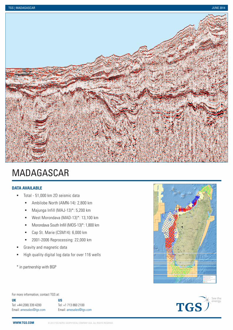
MADAGASCARDATA AVAILABLE
� Total - 51,000 km 2D seismic data
� Ambilobe North (AMN-14): 2,800 km
� Majunga Infill (MAJ-13)*: 5,200 km
� West Morondava (MAD-13)*: 13,100 km
� Morondava South Infill (MOS-13)*: 1,800 km
� Cap St. Marie (CSM14): 6,000 km
� 2001-2006 Reprocessing: 22,000 km
� Gravity and magnetic data
� High quality digital log data for over 116 wells
* in partnership with BGP
UK Tel: +44 (208) 339 4200 Email: [email protected]
US Tel: +1 713 860 2100 Email: [email protected]
For more information, contact TGS at:
_̂
_̂̂_
_̂
_̂_̂
_̂
_̂
_̂
_̂
_̂
_̂
_̂
_̂
_̂
_̂
_̂
_̂
_̂
_̂
_̂
_̂
_̂
_̂
_̂
_̂
_̂
_̂
_̂
_̂
_̂
_̂
_̂
_̂
_̂
_̂
_̂
_̂
_̂_̂
_̂_̂
_̂
_̂
_̂
_̂
_̂
_̂
_̂
_̂
_̂
_̂
_̂
_̂
_̂
_̂
_̂
_̂
_̂
_̂
_̂
_̂
_̂
_̂
_̂
_̂
_̂
_̂
_̂
_̂
_̂
_̂
_̂
_̂
_̂_̂
_̂
_̂
_̂
_̂̂_
_̂
_̂
_̂
_̂
_̂̂_
_̂
_̂̂_̂_
_̂
_̂
_̂
_̂
_̂
_̂̂_̂_̂_̂_̂_
_̂
_̂
_̂
_̂̂_
_̂̂_
_̂
_̂
_̂
_̂̂_
_̂
_̂
_̂
_̂_̂̂_
_̂
_̂
_̂
_̂
_̂
_̂_̂̂_̂_
_̂
_̂
_̂
_̂
_̂
National Geographic, Esri, DeLorme, HERE, UNEP-WCMC, USGS, NASA, ESA, METI, NRCAN, GEBCO, NOAA, increment P Corp.
51°E
51°E
50°E
50°E
49°E
49°E
48°E
48°E
47°E
47°E
46°E
46°E
45°E
45°E
44°E
44°E
43°E
43°E
42°E
42°E
41°E
41°E
40°E
40°E
39°E
39°E
10°S
10°S
11°S
11°S
12°S
12°S
13°S
13°S
14°S
14°S
15°S
15°S
16°S
16°S
17°S
17°S
18°S
18°S
19°S
19°S
20°S
20°S
21°S
21°S
22°S
22°S
23°S
23°S
24°S
24°S
25°S
25°S
26°S
26°S
27°S
27°S
28°S
28°S
_̂ TGS Well Data Available
TGS 2D Seismic (Reprocessing)
TGS 2D Seismic (New)
TGS 2D Seismic (In cooperation with BGP)
TGS 2D Seismic (Vintage)
Held Block
Open Block
WWW.TGS.COM © 2013 TGS-NOPEC GEOPHYSICAL COMPANY ASA. ALL RIGHTS RESERVED.
_̂
_̂̂_
_̂
_̂_̂
_̂
_̂
_̂
_̂
_̂
_̂
_̂
_̂
_̂
_̂
_̂
_̂
_̂
_̂
_̂
_̂
_̂
_̂
_̂
_̂
_̂
_̂
_̂
_̂
_̂
_̂
_̂
_̂
_̂
_̂
_̂
_̂
_̂_̂
_̂_̂
_̂
_̂
_̂
_̂
_̂
_̂
_̂
_̂
_̂
_̂
_̂
_̂
_̂
_̂
_̂
_̂
_̂
_̂
_̂
_̂
_̂
_̂
_̂
_̂
_̂
_̂
_̂
_̂
_̂
_̂
_̂
_̂
_̂_̂
_̂
_̂
_̂
_̂̂_
_̂
_̂
_̂
_̂
_̂̂_
_̂
_̂̂_̂_
_̂
_̂
_̂
_̂
_̂
_̂̂_̂_̂_̂_̂_
_̂
_̂
_̂
_̂̂_
_̂̂_
_̂
_̂
_̂
_̂̂_
_̂
_̂
_̂
_̂_̂̂_
_̂
_̂
_̂
_̂
_̂
_̂_̂̂_̂_
_̂
_̂
_̂
_̂
_̂
National Geographic, Esri, DeLorme, HERE, UNEP-WCMC, USGS, NASA, ESA, METI, NRCAN, GEBCO, NOAA, increment P Corp.
51°E
51°E
50°E
50°E
49°E
49°E
48°E
48°E
47°E
47°E
46°E
46°E
45°E
45°E
44°E
44°E
43°E
43°E
42°E
42°E
41°E
41°E
40°E
40°E
39°E
39°E
10°S
10°S
11°S
11°S
12°S
12°S
13°S
13°S
14°S
14°S
15°S
15°S
16°S
16°S
17°S
17°S
18°S
18°S
19°S
19°S
20°S
20°S
21°S
21°S
22°S
22°S
23°S
23°S
24°S
24°S
25°S
25°S
26°S
26°S
27°S
27°S
28°S
28°S
_̂ TGS Well Data Available
TGS BGP MAD-13 2D Seismic Survey
TGS Existing 2D Seismic Surveys
Held Block
Open Block
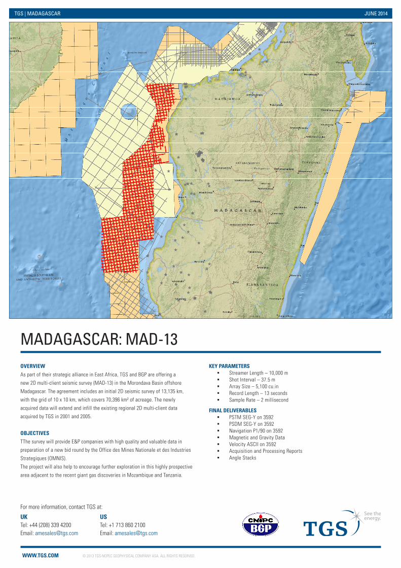
MADAGASCAR: MAD-13
UK Tel: +44 (208) 339 4200 Email: [email protected]
US Tel: +1 713 860 2100 Email: [email protected]
For more information, contact TGS at:
OVERVIEW
As part of their strategic alliance in East Africa, TGS and BGP are offering a
new 2D multi-client seismic survey (MAD-13) in the Morondava Basin offshore
Madagascar. The agreement includes an initial 2D seismic survey of 13,135 km,
with the grid of 10 x 10 km, which covers 70,396 km² of acreage. The newly
acquired data will extend and infill the existing regional 2D multi-client data
acquired by TGS in 2001 and 2005.
OBJECTIVES
TThe survey will provide E&P companies with high quality and valuable data in
preparation of a new bid round by the Office des Mines Nationale et des Industries
Strategiques (OMNIS).
The project will also help to encourage further exploration in this highly prospective
area adjacent to the recent giant gas discoveries in Mozambique and Tanzania.
KEY PARAMETERS � Streamer Length – 10,000 m � Shot Interval – 37.5 m � Array Size – 5,100 cu.in � Record Length – 13 seconds � Sample Rate – 2 millisecond
FINAL DELIVERABLES � PSTM SEG-Y on 3592 � PSDM SEG-Y on 3592 � Navigation P1/90 on 3592 � Magnetic and Gravity Data � Velocity ASCII on 3592 � Acquisition and Processing Reports � Angle Stacks
TGS | MADAGASCAR JUNE 2014