telecom resource planning tool - brochure_apr 09
TRANSCRIPT

8/8/2019 Telecom Resource Planning Tool - Brochure_apr 09
http://slidepdf.com/reader/full/telecom-resource-planning-tool-brochureapr-09 1/12
The Telecom Resource Planning Tool (Trpt) is an implementation of GIS for wireless telecom planning. Trpt integrates Geographic,
Demographic and Terrain information, which facilitates data storage, acquisition & management, and assists multiple query & reportgeneration. It helps optimize all the physical and logical resources that aCommunication Service Provider (CSP) and Infrastructure Service Provider(ISP) needs, to manage its networks and services so as to cater both theactive and passive telecommunication infrastructure markets.
The tool addresses:
• Operations Support System for Network Planning and Maintenance• Business Support System to support and strengthen Marketing
Initiatives, and
• Management Information System which integrates organizationalfunctions such as network coverage planning, marketing, finance andothers.
Telecom Resource Planning Tool (Trpt) facilitates• the identification of best option for actions and investments in the
target areas, rural and urban
• defining the priority locations in each of the selected areas
• optimizing the engineering, marketing and sales planning , so as to improve the results in each area,
• boosting competitiveness, and
• reducing costs.
Trpt –Telecom Resource Planning Tool

8/8/2019 Telecom Resource Planning Tool - Brochure_apr 09
http://slidepdf.com/reader/full/telecom-resource-planning-tool-brochureapr-09 2/12
Product Overview
The Trpt
Advantage:
GIS PlatformThe tool combines highresolution digital mapdata with multipleinformation layers in anIT enabled frameworkcustomized to meetclient requirements.
GIS technology enablesTrpt to integratetopography, terrain andlocation-based data intoanalysis andmanagement processesfor planning. The tool
can be used for networkmaintenance andplanning, strengtheningmarketing and salesinitiatives, customercare, and as a topmanagementinformation system tointegrate variousorganizationalfunctions.
Planning tool to alsovalidate networkplanning carried out byequipment suppliers andmonitors installation,and as a result, reduces
capital expenditure.
Focused Industry Segments:• Mobile network operators
• Telecommunication Planning
• Internet & Intranet providers
• Military communications
• Emergency services
• Private networks
• Radio networks planning
Features• Wireless Planning
• Generating Coverage and evaluation reports• Generating Backhaul Connectivity Reports
• Radio Link Analysis
• Terrain Cross section
• R-LOS Analysis
• Grid Planning
• Creating and Analyzing a region using grids
• Automated Planning• Finding Potential Locations
• Capex Estimation
• SACFA Clearance
8/8/2019 Telecom Resource Planning Tool - Brochure_apr 09
http://slidepdf.com/reader/full/telecom-resource-planning-tool-brochureapr-09 3/12
Functionalities
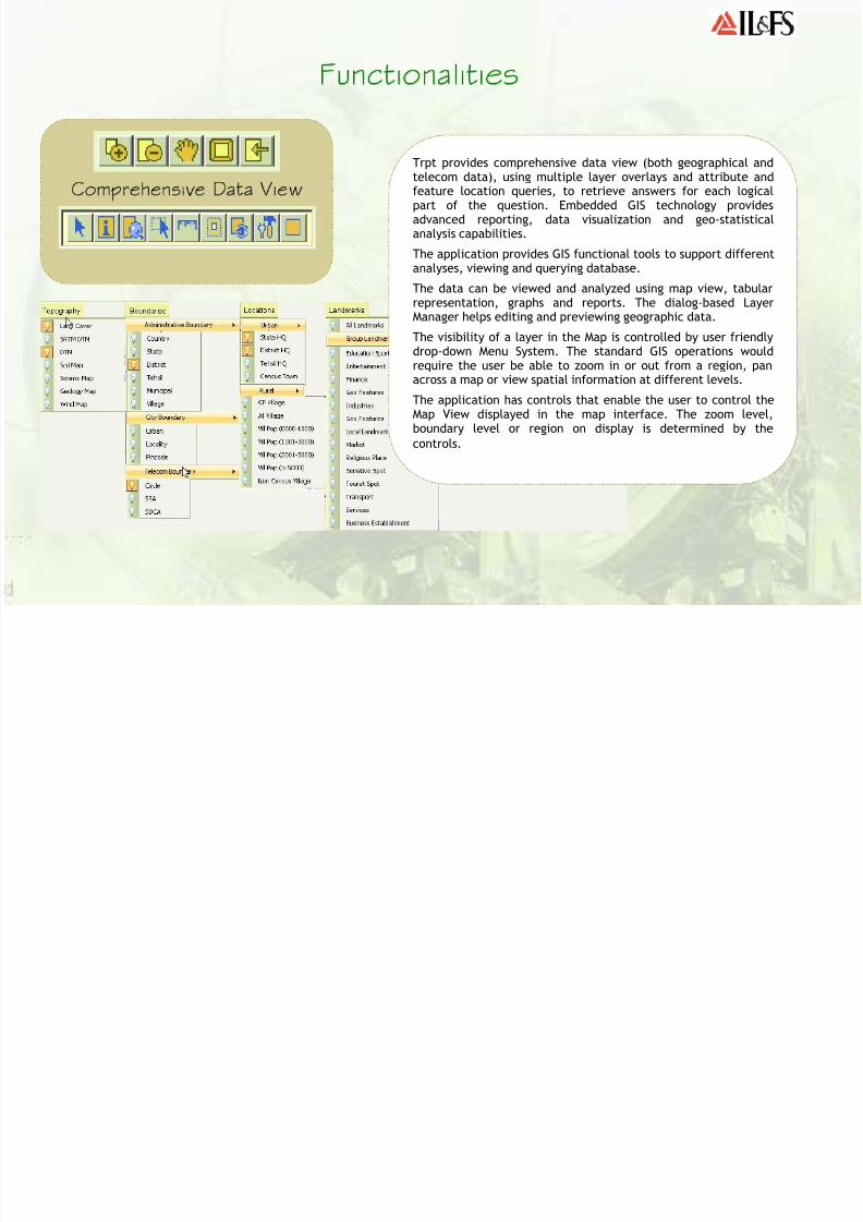
Comprehensive Data View
Trpt provides comprehensive data view (both geographical andtelecom data), using multiple layer overlays and attribute andfeature location queries, to retrieve answers for each logicalpart of the question. Embedded GIS technology providesadvanced reporting, data visualization and geo-statisticalanalysis capabilities.
The application provides GIS functional tools to support differentanalyses, viewing and querying database.
The data can be viewed and analyzed using map view, tabularrepresentation, graphs and reports. The dialog-based Layer
Manager helps editing and previewing geographic data.The visibility of a layer in the Map is controlled by user friendlydrop-down Menu System. The standard GIS operations wouldrequire the user be able to zoom in or out from a region, panacross a map or view spatial information at different levels.
The application has controls that enable the user to control theMap View displayed in the map interface. The zoom level,
boundary level or region on display is determined by thecontrols.

8/8/2019 Telecom Resource Planning Tool - Brochure_apr 09
http://slidepdf.com/reader/full/telecom-resource-planning-tool-brochureapr-09 4/12
Grid Planning
Grid Planning Module helps to select potential
areas on a map for RF planning. The user canselect a region, specify the area type and gridsize so as to create the grids.
The Grid Table displays the following coveragewise information on each grid.
(a) Areas of populated land types
(b) Urban/Rural population
(c) Route lengths
(d) Landmarks
(e) Relative priority of each grid
8/8/2019 Telecom Resource Planning Tool - Brochure_apr 09
http://slidepdf.com/reader/full/telecom-resource-planning-tool-brochureapr-09 5/12
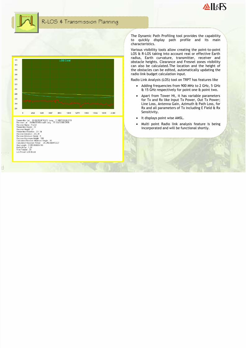
The Dynamic Path Profiling tool provides the capabilityto quickly display path profile and its maincharacteristics.
Various visibility tools allow creating the point-to-pointLOS & R-LOS taking into account real or effective Earthradius, Earth curvature, transmitter, receiver and
obstacle heights. Clearance and Fresnel zones visibilitycan also be calculated.The location and the height of the obstacles can be edited, automatically updating theradio link budget calculation input.
Radio Link Analysis (LOS) tool on TRPT has features like
• Adding frequencies from 900 MHz to 2 GHz, 5 GHz
& 15 GHz respectively for point one & point two.• Apart from Tower Ht, it has variable parameters
for Tx and Rx like Input Tx Power, Out Tx Power;Line Loss, Antenna Gain, Azimuth & Path Loss, forRx and all parameters of Tx including E Field & RxSensitivity.
• It displays point wise AMSL.
• Multi point Radio link analysis feature is beingincorporated and will be functional shortly.
R-LOS & Transmission Planning

8/8/2019 Telecom Resource Planning Tool - Brochure_apr 09
http://slidepdf.com/reader/full/telecom-resource-planning-tool-brochureapr-09 6/12
Automated Planning
The AutoPlan Module of the tool selects potentiallocations for sites. In Auto planning the grids areprocessed in descending order of scoring.
Urban grids are normally of smaller size typically 0.5 to1 km. rural Grids are typically 1 to 4 km. In the urbangrid the grid center is considered as the default sitelocation.
Within a Rural grid site location is selected based on
(a) Village Population
(b) Highways
(c) Landmarks
At each potential location the cell orientation isdetermined by maximizing coverage as per above
criteria and avoiding maximum permissible overlap.

8/8/2019 Telecom Resource Planning Tool - Brochure_apr 09
http://slidepdf.com/reader/full/telecom-resource-planning-tool-brochureapr-09 7/12
Coverage Prediction & Site Planning Module
Trpt has advance coverage prediction algorithms for modeling microwave point-to-point, point-to-multipoint; fixed and mobile radio systems based on standards andrecommendations. The models support prediction at varied terrain and topographicalconditions. The propagation models cover a distance range from several meters up to
150 Km and frequencies from 100 MHz up to 3000 MHz.
Site planning tool enables user to plot coverage corresponding to a BTS site withcategorization level like Indoor, In car and Outdoor coverage. Tools also giveflexibility for manual and automated site planning.

8/8/2019 Telecom Resource Planning Tool - Brochure_apr 09
http://slidepdf.com/reader/full/telecom-resource-planning-tool-brochureapr-09 8/12
As part of location validation, Trptanalyses the status of a proposed towerrelative to the Airport ClearanceObligations for erection of a new BTSfrom the concerned Authorities, like.Airport Authority of India.
The tool considers the basic striplength, approach surfaces, transitionarea, inner and outer horizontalsurface, and ARP and calculates thepermissible elevation for the proposed
tower.
SACFA Clearance Module
8/8/2019 Telecom Resource Planning Tool - Brochure_apr 09
http://slidepdf.com/reader/full/telecom-resource-planning-tool-brochureapr-09 9/12
Drive Test & Field Data Analysis
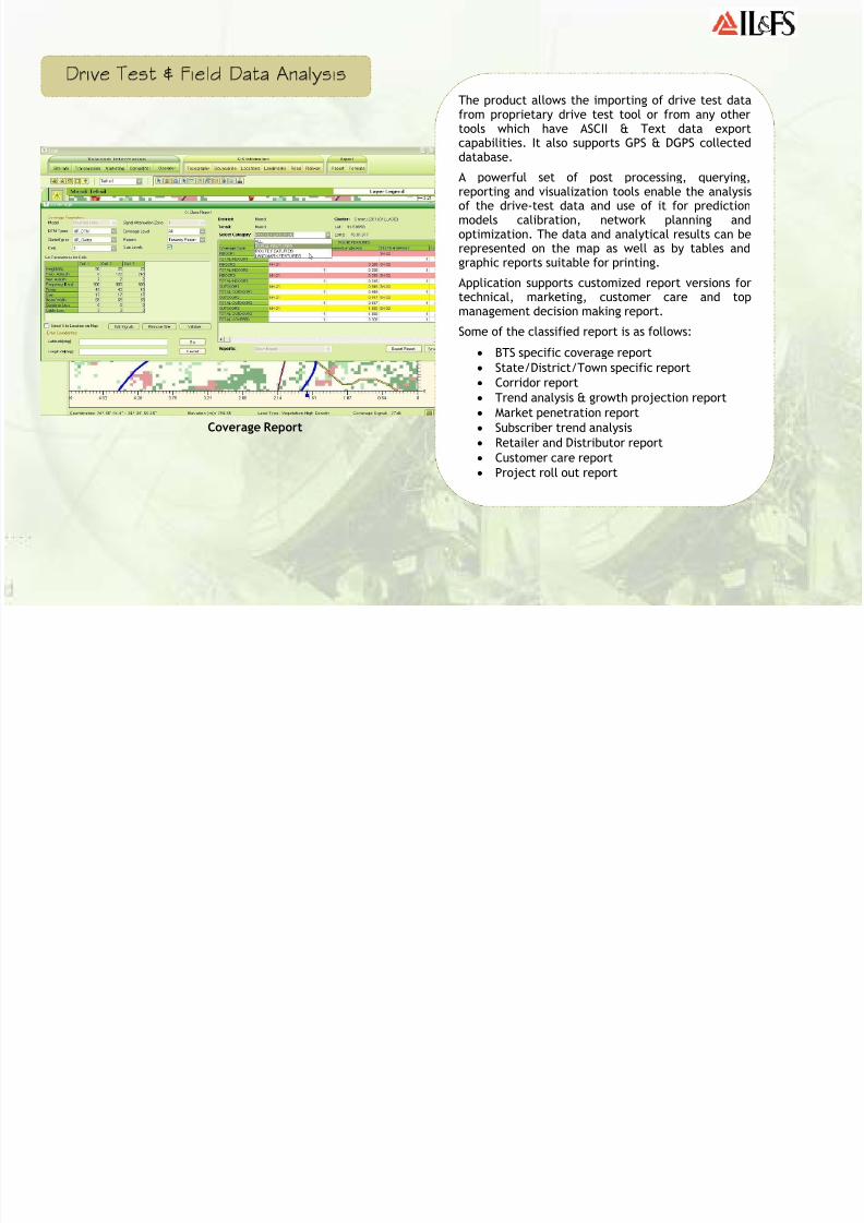
Coverage Report
The product allows the importing of drive test datafrom proprietary drive test tool or from any othertools which have ASCII & Text data exportcapabilities. It also supports GPS & DGPS collecteddatabase.
A powerful set of post processing, querying,reporting and visualization tools enable the analysisof the drive-test data and use of it for predictionmodels calibration, network planning andoptimization. The data and analytical results can berepresented on the map as well as by tables andgraphic reports suitable for printing.
Application supports customized report versions fortechnical, marketing, customer care and topmanagement decision making report.
Some of the classified report is as follows:
• BTS specific coverage report
• State/District/Town specific report
• Corridor report
• Trend analysis & growth projection report
• Market penetration report
• Subscriber trend analysis• Retailer and Distributor report
• Customer care report
• Project roll out report

8/8/2019 Telecom Resource Planning Tool - Brochure_apr 09
http://slidepdf.com/reader/full/telecom-resource-planning-tool-brochureapr-09 10/12
Customised Geographic Database & Structured RDBMS
The application version 2.5 is designed to act as a basic Map interface that supports standard GIS viewing and analysisoperations required for mobile network planning. The application uses standard models to predict coverage and microwave
link status. The system also maintains a database of demographic and network related information to generate customizedreports. The software is developed on the world’s leading Geographical Information System SDK.
GIS technology enables Trpt users to integrate the topography, terrain and location-based data into analysis and managementprocesses in network planning and operations, marketing and sales, customer care, data management, and a variety of otherplanning activities. The user friendly interface, data conversion and import/export capabilities of the application helps tointegrate the location based data, including telecom data from multiple sources and diverse formats, easily and effectivelyfor streamlining the planning activity. Location-based data integration helps to improve analysis and management processes.
Trpt can function as a stand-alone radio network planning application, as well as a multi-user system for editing/viewing dataon RDBMS (Oracle, Citrix Server and Generic GIS database). The scaleable and configurable data model allows for themodeling of various network architectures: point-to-point, point-to-multipoint, point-to area or multi-service. Open databasearchitecture ensures easy integration with standard-based legacy systems. Application supports generic GIS database in bothraster and vector formats. Vector data can be stored as point, line and polygon features and raster data can be stored in both
grid and image format.
8/8/2019 Telecom Resource Planning Tool - Brochure_apr 09
http://slidepdf.com/reader/full/telecom-resource-planning-tool-brochureapr-09 11/12
Customisation & Integration
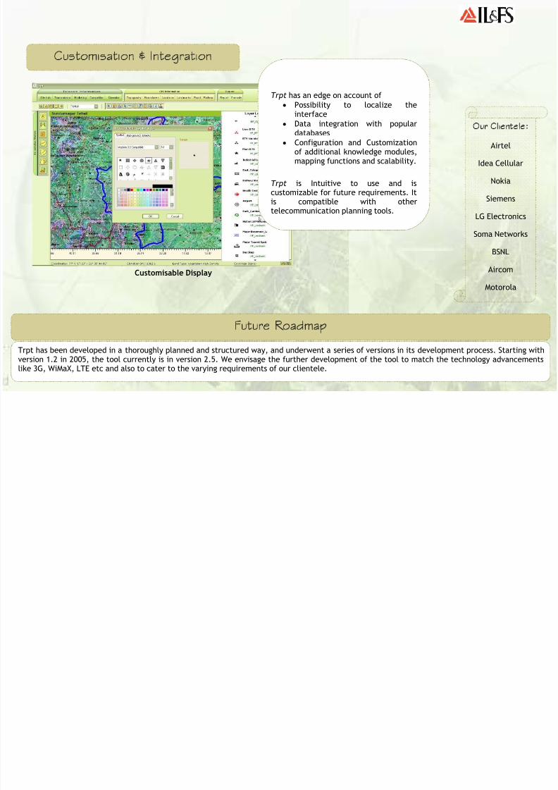
Customisable Display
Future Roadmap
Trpt has been developed in a thoroughly planned and structured way, and underwent a series of versions in its development process. Starting withversion 1.2 in 2005, the tool currently is in version 2.5. We envisage the further development of the tool to match the technology advancementslike 3G, WiMaX, LTE etc and also to cater to the varying requirements of our clientele.
Trpt has an edge on account of
• Possibility to localize theinterface
• Data integration with populardatabases
• Configuration and Customizationof additional knowledge modules,mapping functions and scalability.
Trpt is Intuitive to use and iscustomizable for future requirements. Itis compatible with othertelecommunication planning tools.
Our Clientele:
Airtel
Idea Cellular
Nokia
Siemens
LG Electronics
Soma Networks
BSNL
Aircom
Motorola

8/8/2019 Telecom Resource Planning Tool - Brochure_apr 09
http://slidepdf.com/reader/full/telecom-resource-planning-tool-brochureapr-09 12/12
_________________________
IL&FS Ltd. 4B, Core 4, India Habitat Centre
Lodhi Road
New Delhi 110003 _________________________Ph: + 91 11 2468 2060Fax: + 91 11 2412 2490
_________________________
IL&FS Ecosmart Ltd.Level 1, NTBCL BuildingDND Flyway - Toll Plaza
NOIDA -201301 __________________________
Ph: + 91 120 2488763/4Fax: + 91 120 2510440
Infrastructure Leasing & Financial Services (IL&FS),specifically mandated with the commercialisation of infrastructure projects, performs the vital task of
structuring infrastructure projects on a Public PrivatePartnership (PPP) framework and taking them to fruition.
IL&FS Ecosmart is a strategic initiative and wholly ownedsubsidiary of Infrastructure Leasing and Financial ServicesLtd, India, and promotes environmentally sustainablepractices to create value for people. IL&FS Ecosmart'sexpertise spans across Geo-Spatial Solutions, EnvironmentalInformation Processing, Environmental Management Plans,Urban Infrastructure, Waste Management, Resettlement andRehabilitation, Environmental Capacity-Building andTraining.
Ecosmart’s Spatial Solutions Division provides a wide rangeof services to telecom sector with respect to RF planning
and Wireless Network Modeling application. Ecosmart is oneof the leading suppliers of high quality digital geographicdata product for RF/Wireless network planning, design andperformance optimization. The professionally managedservices targets all the cellular sectors like fixed wireless(WLL, LMDS) and mobile wireless (GSM, CDMA, TDMA andUMTS). The services offered cover a variety of wirelessapplications including preliminary regional networkplanning, coverage analysis, line of sight analysis, networkexpansion and site acquisition.
Ecosmart has a complete state-of-art infrastructure andowns one of the largest off-the-self international databaseswith complete coverage of India & Asia Pacific. We followinternational standards which meet the requirement
specification of global funding agencies like World Bank,ADB, USAID etc. We focus on quality, accuracy and timely
delivery with very competitive pricing.