tectonostratigraphy, sm-nd isotope and u-pb age data of ... · described and sampled. particular...
TRANSCRIPT

SUMMARYThis report demonstrates an application of combined remapping, core relogging and
isotopic dating techniques to unravel the complex tectonostratigraphy across the SuperiorBoundary Zone. The work aims to clarify the structure, mineral potential and extent of theThompson Nickel Belt and the adjacent Kisseynew Domain in north-central Manitoba. The Sm-Nd isotope methodsand U-Pb dating applied to these Precambrian medium- to high-grade gneiss units provide a clear distinction between1) Neoarchean basement, 2) cover rocks (hosting nickel deposits), 3) juvenile Paleoproterozoic paragneiss (probablythrust in from the Kisseynew Domain), and 4) a Mesoarchean gneiss complex (the likely host of important preciousmetal prospects). A summary of preliminary results is presented from Pearson Lake, the Mel zone and Setting Lake.The continuing work encompasses Rock Lake, Assean Lake, Leftrook and Harding lakes, and various locations in theThompson Nickel Belt.
INTRODUCTIONThe key to rigorous mapping of Precambrian gneiss in north-central Manitoba lies in establishing unique
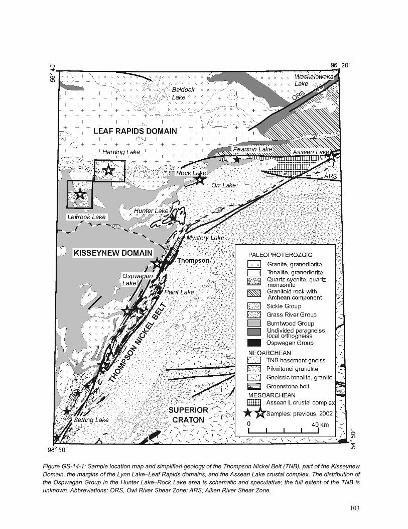
stratigraphic sequences and determining their ages. Mapping and core logging have been combined with Sm-Nd isotope and U-Pb age data to test stratigraphic, tectonic and metallogenic models (Zwanzig et. al., 2001). The projectarea currently extends along the boundary between the Kisseynew Domain (KD) and Thompson Nickel Belt (TNB) inthe southeast, and the Lynn Lake–Leaf Rapids domains and Assean Lake crustal complex (Böhm et al., 2002) in thenorth (Fig. GS-14-1). Because outcrop is limited in large parts of the area, surface mapping was combined with relog-ging of company-owned drill core (Inco Technical Services Ltd., Nuinsco Resources Limited, Hudson Bay Explorationand Development Co. Ltd. and Strider Resources Ltd.). This collaborative work has led to the recognition of previouslydistinguished stratigraphic sequences, which include the Neoarchean basement gneiss and the PaleoproterozoicOspwagan Group in the TNB, the Mesoarchean Assean Lake crustal complex in the northeast, and the PaleoproterozoicBurntwood, Sickle and Grass River groups in the KD. Many of these assemblages contain similar looking orthogneissand migmatitic greywacke-gneiss or semipelite derived from turbidite to marine shelf or basin deposits, units that cannot be distinguished using petrographic analysis alone. The ages (TCR Nd model and U-Pb igneous, metamorphicand detrital zircon ages) of these units are critical in establishing a geological and therefore metallogenic frameworkfor the region. Major- and trace-element geochemistry and petrographic work provide additional data to distinguish thevarious units.
This report provides a current geological overview of the project area and delineates the areas of new mapping,core logging and sampling. Also included is a preliminary summary of tectonostratigraphy and the geochronologydetermined from samples collected during 2001 along the northern extension of the TNB (Mel zone), from further tothe northeast (Pearson Lake) and from earlier sampling in the south (Setting Lake). During the summer of 2002, mapping and surface sampling were carried out on Leftrook and Harding lakes, 60 km northwest of Thompson. Thisongoing work is expected to provide petrographic and isotopic data for stratigraphic units typical of the north flank ofthe KD. Drill core was relogged and samples collected from five sites along the TNB and possibly beyond its northernextension. These sites are, from southwest to northeast,1) Soab Lake area,2) Tailor River (Kipper),3) Birchtree Mine area,4) Rock Lake (50 km northeast of Thompson), and5) Assean Lake (Hunter and Tex claims).The new samples from these areas are expected to provide petrographic, geochemical, isotopic and geochronologicaldata for the Paleoproterozoic rocks and the Archean gneiss in the TNB and the northern part of the Superior Boundary
TECTONOSTRATIGRAPHY, SM-ND ISOTOPE AND U-PB AGE DATA OF THETHOMPSON NICKEL BELT AND KISSEYNEW NORTH AND EAST MARGINS
(NTS 63J, 63O, 63P, 64A, 64B), MANITOBAby H.V Zwanzig and Ch.O. Böhm1
Zwanzig, H.V. and Böhm, Ch.O. 2002: Tectonostratigraphy, Sm-Nd isotope and U-Pb age data of the ThompsonNickel Belt and Kisseynew north and east margins (NTS 63J, 63O, 63P, 64A, 64B), Manitoba; in Report of Activities2002, Manitoba Industry, Trade and Mines, Manitoba Geological Survey, p. 102-114.
102
GS-14
1 Department of Earth and Atmospheric Sciences, University of Alberta, Edmonton, Alberta T6G 2E3
103
Figure GS-14-1: Sample location map and simplified geology of the Thompson Nickel Belt (TNB), part of the KisseynewDomain, the margins of the Lynn Lake–Leaf Rapids domains, and the Assean Lake crustal complex. The distribution ofthe Ospwagan Group in the Hunter Lake–Rock Lake area is schematic and speculative; the full extent of the TNB isunknown. Abbreviations: ORS, Owl River Shear Zone; ARS, Aiken River Shear Zone.
Zone. The dataset will augment the results of the work done in the Mel zone and at Pearson Lake in 2001. The work isintended to delineate the extent of the various tectonic domains more fully and to help resolve stratigraphic and structural problems where units are interleaved at their boundaries.
GEOLOGICAL OVERVIEWThe region between Setting Lake, Assean Lake and Leftrook Lake includes the collisional boundary zone of the
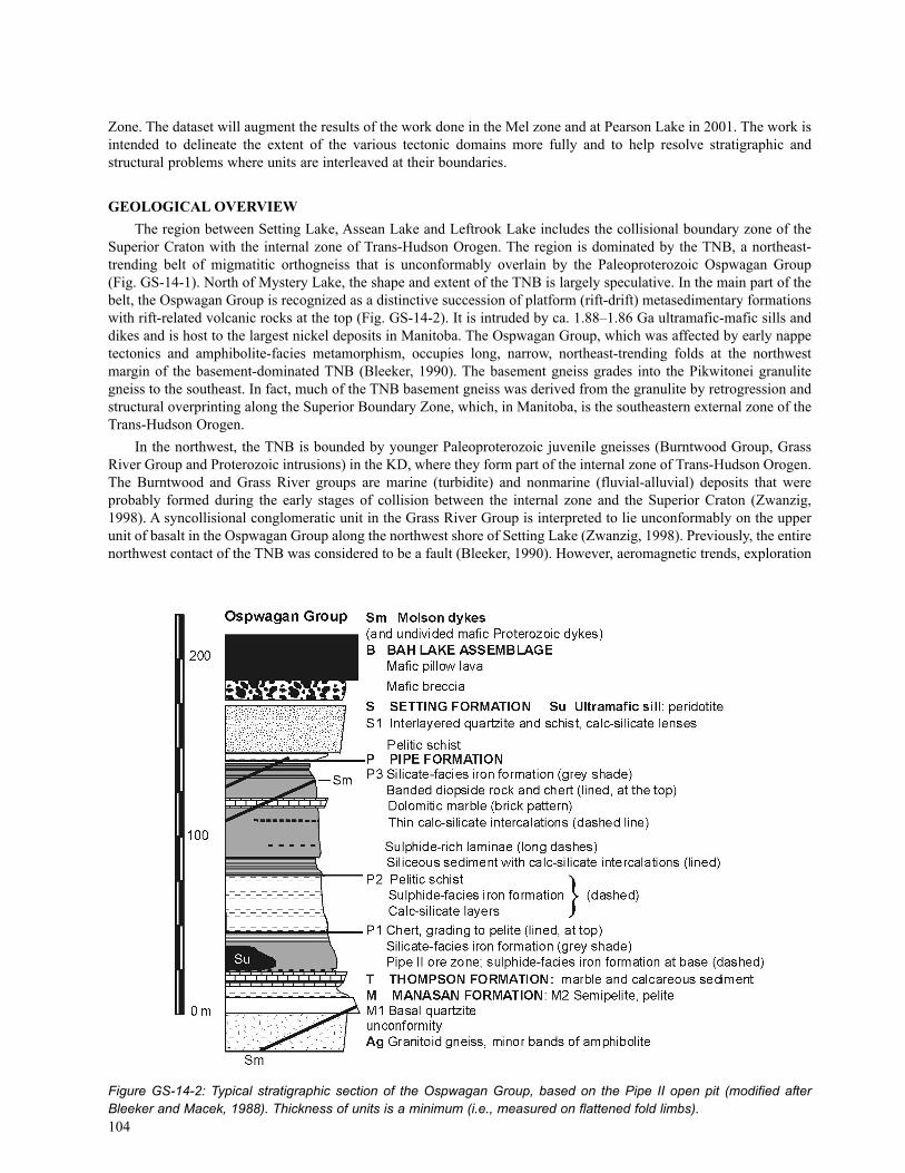
Superior Craton with the internal zone of Trans-Hudson Orogen. The region is dominated by the TNB, a northeast-trending belt of migmatitic orthogneiss that is unconformably overlain by the Paleoproterozoic Ospwagan Group(Fig. GS-14-1). North of Mystery Lake, the shape and extent of the TNB is largely speculative. In the main part of thebelt, the Ospwagan Group is recognized as a distinctive succession of platform (rift-drift) metasedimentary formationswith rift-related volcanic rocks at the top (Fig. GS-14-2). It is intruded by ca. 1.88–1.86 Ga ultramafic-mafic sills anddikes and is host to the largest nickel deposits in Manitoba. The Ospwagan Group, which was affected by early nappetectonics and amphibolite-facies metamorphism, occupies long, narrow, northeast-trending folds at the northwest margin of the basement-dominated TNB (Bleeker, 1990). The basement gneiss grades into the Pikwitonei granulitegneiss to the southeast. In fact, much of the TNB basement gneiss was derived from the granulite by retrogression andstructural overprinting along the Superior Boundary Zone, which, in Manitoba, is the southeastern external zone of theTrans-Hudson Orogen.
In the northwest, the TNB is bounded by younger Paleoproterozoic juvenile gneisses (Burntwood Group, GrassRiver Group and Proterozoic intrusions) in the KD, where they form part of the internal zone of Trans-Hudson Orogen.The Burntwood and Grass River groups are marine (turbidite) and nonmarine (fluvial-alluvial) deposits that were probably formed during the early stages of collision between the internal zone and the Superior Craton (Zwanzig,1998). A syncollisional conglomeratic unit in the Grass River Group is interpreted to lie unconformably on the upperunit of basalt in the Ospwagan Group along the northwest shore of Setting Lake (Zwanzig, 1998). Previously, the entirenorthwest contact of the TNB was considered to be a fault (Bleeker, 1990). However, aeromagnetic trends, exploration
104
Figure GS-14-2: Typical stratigraphic section of the Ospwagan Group, based on the Pipe II open pit (modified afterBleeker and Macek, 1988). Thickness of units is a minimum (i.e., measured on flattened fold limbs).

drill core and new structural mapping indicate that many faults and mylonite zones are relatively young and some cutnortheast across the northern extension of the TNB (Fig. GS-14-1). Moreover, previously unpublished Sm-Nd isotopedata suggest that granites within the eastern margin of the KD were contaminated by Archean crust. They may havebeen locally derived completely from Archean rocks and are now structurally interleaved with the juvenile Proterozoicunits. Thus, the collisional boundary zone involves depositional contacts and structural contacts that were refolded andfaulted during protracted deformation, and injected by various crust- to mantle-derived melts.
In the west, at Leftrook and Harding lakes, paragneiss and local amphibolite units form a succession typical of thenorth flank of the KD. They are mapped as greywacke-migmatite, similar to the Burntwood Group, and arkosic gneiss,equivalent to the Sickle Group exposed in the southern part of the Lynn Lake Domain (Corkery and Lenton, 1980).These rocks have the potential to provide an important stratigraphic section, with geochronological and Sm-Nd isotopicdata, for the presumably juvenile rocks in the northern KD.
At Assean Lake, an ancient (Mesoarchean) crustal complex and prominent shear zones mark the margin of theSuperior Craton. This complex was previously considered to be Proterozoic (Corkery and Lenton, 1980), but isotopeand geochronological studies by Böhm et al. (2000, 2002) revealed Mesoarchean ages for felsic magmatism andgreywacke-gneiss, with the latter containing ca. 3.2 to 3.9 Ga detrital zircons. Units of amphibolite and iron formationwere also interpreted to be part of the Assean Lake crustal complex by Böhm et al. (2000). Mesoarchean ages to thesouth, along the Aiken River Shear Zone (Böhm et al., 2000 and unpublished data), suggest that the ancient crust isstructurally interleaved with the Neoarchean, Superior-type gneiss and that the full extent of Mesoarchean crust alongthe Superior Boundary Zone is unknown. Predominantly Archean Nd model ages for orthogneiss between Assean Lakeand the Owl River Shear Zone, further to the north, indicate the presence of mixed gneiss and variably contaminatedplutons (Böhm et al., 2002). The orthogneiss was previously considered to represent simple Proterozoic intrusions andminor paragneiss of the Trans-Hudson internal zone (Leaf Rapids Domain). The convergence of the major shear zonesand crustal elements is located at Pearson Lake and may make this area particularly important for a tectonic interpre-tation of the collisional boundary zone.
OBJECTIVES AND METHODOLOGYMapping
Surface mapping was carried out from fly-in camps on Leftrook and Harding lakes. Outcrop examination and sampling were restricted to shoreline exposures. Sample sets were collected for petrographic work on all units, and themost typical, least-veined varieties were collected and trimmed for geochemical and Sm-Nd isotopic studies. A limitedset of predominantly intrusive rocks was collected as fresh broken samples of 15 kg or greater for U-Pb dating (zircon,monazite, sphene). The purpose of this work is to determine the age and test the validity of the stratigraphic sequenceof sedimentary units established by Corkery and Lenton (1980) along the northern margin of the KD. The resultinggeochronological and geochemical database will serve as a reference for a comparison with similar units that are struc-turally intercalated at, or adjoining, the margin of the TNB. The data are expected to help identify lithotectonic units inthe blocks of complex, mixed gneiss.
Additional surface samples for U-Pb dating and Sm-Nd isotope work were collected on Fish Lake (west of SettingLake), 100 km southwest of Thompson. These samples may verify preliminary Nd model ages, given in this report, thatsuggest interleaving of Archean- and Proterozoic-derived gneissic units in an area that was previously considered tocontain only juvenile Proterozoic rocks.
Core loggingMuch of the bedrock, particularly the sedimentary units in the TNB and northeastern part of the KD, are covered
by lakes and muskeg. Access to mineral exploration drill core is therefore essential to reinterpreting these areas. At present,five exploration companies are collaborating with the Manitoba Geological Survey (MGS) and the University ofAlberta Radiogenic Isotope Facility by providing critical company-owned core, drill logs, location data, funding and/orother support. Core is laid out in the company yard or at the MGS storage site, contacts are marked and units aredescribed and sampled. Particular attention is given to distinctive units (e.g., marble or basal quartzite) and contactsthat may be faults or unconformities. Stratigraphic successions are then compared to type sections in the TNB (e.g.,Bleeker and Macek, 1988; Fig. GS-14-2) or assemblages in the KD (e.g., Corkery and Lenton, 1980) or elsewhere (e.g.,Böhm, 1997; Böhm et al., 2002). Petrographic and geochemical studies carried out on core samples provide a databasefor comparing core in different areas. Radiometric dating can yield rigorous constraints for different tectonic units withsimilar appearance.
105
Sm-Nd isotope methodsThe various units of orthogneiss and paragneiss along the Superior Boundary Zone and in the adjacent KD have
yielded a wide range of ages that are not apparent from mapping and petrographic work. The Sm-Nd isotope methodsprovide a convenient technique of distinguishing the major tectonic assemblages at lower expense than precision U-Pbgeochronology. However, these methods do not yield simple ages and may require a discussion of their application,interpretation and limitations, as provided in this section of the report.
The Sm-Nd isotope methods are useful in establishing the crustal evolution of Precambrian terrains such as thewestern Superior Province and the Trans-Hudson Orogen in Manitoba. Radiogenic isotopes can either be used for dating (e.g., U-Pb zircon dating) or, in the context of geochemistry, to identify provenance and study petrogeneticprocesses (e.g., Rb-Sr and Sm-Nd isotope methods). Since the different elements used in the isotope studies vary intheir chemical and physical properties, individual isotope systems vary in their sensitivity to particular petrologicalprocesses. Samarium and neodymium — both being rare earth elements (REE) — have very similar chemical and physical characteristics. Rubidium and strontium, in contrast, are geochemically distinct, incompatible trace elementsthat are commonly fractionated by secondary processes (e.g., tectonometamorphic processes, fluid-rock interaction).Rubidium-strontium isotope data for metamorphic rocks are therefore rarely useful for constraining crust formationages. Samarium and neodymium, on the other hand, are compatible trace elements (preferentially enriched in the mineral phases), have small bulk partition coefficients for most petrogenetic processes and are relatively immobile,even at higher metamorphic grade. Thus, the Sm-Nd whole-rock technique can be used in determining crust formationages. However, relatively small variations in the Sm/Nd ratio are common in cogenetic gneissic rock types and there-fore limit the time resolution of the Sm-Nd isotope system. For medium- and high-grade gneisses, crust formation agesare protolith ages and approximately represented by Nd model ages.
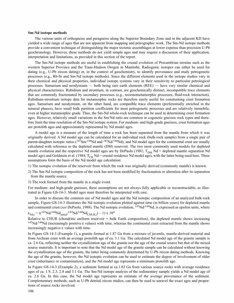
A model age is a measure of the length of time a rock has been separated from the mantle from which it was originally derived. A Nd model age can be calculated for an individual rock (bulk-rock sample) from a single pair ofparent-daughter isotopic ratios (147Sm/144Nd and 143Nd/144Nd), and Nd model ages for the continental crust are usuallycalculated with reference to the depleted mantle (DM) reservoir. The two most commonly used models for depletedmantle evolution and the respective Nd model ages are by DePaolo (1981; TDM Nd = depleted mantle separation Ndmodel age) and Goldstein et al. (1984; TCR Nd = crustal residence Nd model age), with the latter being used here. Threeassumptions form the basis of the Nd model age calculation:1) The isotopic evolution of the reservoir from which the rock was originally derived (commonly mantle) is known.2) The Sm-Nd isotopic composition of the rock has not been modified by fractionation or alteration after its separation
from the mantle source.3) The rock formed from the mantle in a single event.For medium- and high-grade gneisses, these assumptions are not always fully applicable or reconstructable, as illus-trated in Figure GS-14-3. Model ages must therefore be interpreted with care.
In order to discuss the common use of Nd model ages and the Nd isotopic composition of an analyzed bulk-rocksample, Figure GS-14-3 illustrates the Nd isotopic evolution plotted against time (in billion years) for depleted mantleand continental crust (see DePaolo, 1988). The Nd isotopic evolution, 143Nd/144Nd, is expressed as epsilon units, whereεNd,t = ((143Nd/144Ndinitial/
143Nd/144NdCHUR,t) – 1) x 104
Relative to CHUR (chondritic uniform reservoir = bulk Earth composition), the depleted mantle shows increasing143Nd/144Nd (increasingly positive ε values) with time, whereas the continental crust extracted from the mantle showsincreasingly negative ε values with time.In Figure GS-14-3 (Example 1), a granite formed at 1.87 Ga from a mixture of juvenile, mantle-derived material andfrom Archean crust with an average protolith age of ca. 3.1 Ga. The calculated Nd model age of the granite sample isca. 2.6 Ga, reflecting neither the crystallization age of the granite nor the age of the crustal source but that of the mixedsource materials. It is important to note that the Nd model age of the granite sample can be calculated without knowingthe crystallization age of the granite, the latter being commonly determined by U-Pb zircon dating methods. Knowingthe age of the granite, however, the Nd isotopic evolution can be used to estimate the degree of involvement of oldercrust (inheritance or contamination), and the Nd model age represents a minimum protolith age.In Figure GS-14-3 (Example 2), a sediment formed at ca.1.83 Ga from various source rocks with average residenceages of ca. 1.9, 2.3, 2.8 and 3.1 Ga. The Sm-Nd isotope analysis of the sedimentary sample yields a Nd model age ofca. 2.6 Ga. In this case, the Nd model age represents an estimate of the average provenance of the sediment.Complementary methods, such as U-Pb detrital zircon studies, can then be used to unravel the exact ages and propor-tions of source rocks involved.106

In summary, the Sm-Nd isotope method represents a relatively rapid and inexpensive technique that is most successfully applied in the reconnaissance of Precambrian metamorphic terrains. The method has the potential to yieldthe protolith history of old high-grade gneisses and to distinguish between Archean and Proterozoic crust. As such, Ndisotopic mapping works best on a regional scale by comparing Nd model ages of felsic meta-igneous and metasedi-mentary rocks of similar composition across major crustal sutures, such as the Superior Boundary, Assean Lake andAiken River deformation zones along the northwestern margin of the Superior Province (Fig. GS-14-1).
PRELIMINARY RESULTSPearson Lake
The geotectonic position of Pearson Lake is important for at least two reasons:1) The northeast-trending Superior Boundary Zone and Owl River Shear Zone, which possibly separate mixed Archean
and Proterozoic crust from dominantly Proterozoic crust along the northwestern margin of the Superior craton, meetin the Pearson Lake area (Fig. GS-14-1).
2) The northern extension of the Thompson Nickel Belt could be located along this margin.A dominant granodiorite orthogneiss unit has been identified and dated at Pearson Lake (e.g., Zwanzig et al., 2001).Samarium-neodymium isotope analysis of the granodiorite gneiss yields a crustal residence (TCR) Nd model age of ca.3.3 Ga and current εNd of approximately –39, clearly indicating the antiquity of the granodiorite gneiss precursor. Based
107
Figure GS-14-3: Neodymium isotopic evolution with time, for depleted mantle and Precambrian continental crust (graniteand sedimentary rock examples; see text for explanations).
on our U-Pb zircon dating, the crystallization age of the granodiorite gneiss is 3185 ± 7 Ma, similar to orthogneiss inthe ancient Assean Lake crustal complex (e.g., Böhm et al, 2002). The granodiorite orthogneiss at Pearson Lake wasmetamorphosed at 1782.6 ± 1.1 Ma (metamorphic zircon), and separates paragneiss on the north shore from migma-tized metagreywacke on the south shore. Results from Sm-Nd isotope analysis show that these paragneiss units are notrelated to each other. The southern metagreywacke yielded a ca 2.2 Ga TCR Nd model age and εNd at 1.8 Ga of approx-imately +2, which suggests that this metagreywacke dominantly or entirely consists of source rocks that are less than2.0 Ga, similar to Burntwood Group metasedimentary rocks of the KD with which it can possibly be correlated.Metamorphic zircons from a leucosome sample in the southern metagreywacke indicate that it was metamorphosed atca. 1802 Ma, a typical age for the thermal peak in the KD (Machado et al., 1999). A TCR Nd model age of ca. 2.5 Gaand εNd of approximately –1 at 1850 Ma, in comparison, indicate that the paragneiss to the north likely sampledPaleoproterozoic and Neoarchean crust (detrital zircon 207Pb/206Pb ages of 2258, 2571 and 2696 Ma were determinedin this study).
In summary, Sm-Nd isotope and U-Pb age data suggest that orthogneiss at Pearson Lake might represent a westerly extension of the Mesoarchean Assean Lake crustal complex. At Pearson Lake, Mesoarchean orthogneiss isinterleaved with Paleoproterozoic- to Neoarchean-derived paragneiss in the north, and in fault contact with predomi-nantly Paleoproterozoic-derived greywacke-migmatite (probably Burntwood Group) to the south.
Mel zoneThe Mel zone was previously shown on compilation maps as part of the KD (e.g., Manitoba Energy and Mines,
1995). However, magnetic trends extend northwest from the TNB at Mystery Lake and exploration drilling by IncoTechnical Services Limited has encountered high-grade paragneiss similar to the Ospwagan Group (Fig. GS-14-4). Acollaborative program of relogging, geochemistry and Sm-Nd isotope work was undertaken to resolve the geology ofthis complex area. This paper presents a summary of new petrographic and Nd isotopic results, which suggest that theMel zone between Mystery Lake and Hunter Lake is part of the northwestern extension of the TNB.
The following lithological units from the TNB are based on a summary review of the Inco drillhole records andwere tentatively identified during relogging:1) Archean basement gneiss2) lower part of the Ospwagan Group (Manasan Formation M1 quartzite to Pipe Formation P2 pelite and P3 silicate
iron formation)3) greywacke-mudstone–derived gneiss (garnet-biotite gneiss with granitoid leucosome belonging to, or similar to, the
Burntwood Group)4) amphibolite5) pegmatite and granite veins and sheets, considered to be ProterozoicThe Ospwagan Group is very coarsely recrystallized with garnet porphyroblasts and quartz-sillimanite knots(faserkiesel) reaching 60 mm in length. True thicknesses of Ospwagan Group encountered in the various sections rangefrom 35 to 100 m. Basal quartzite lies — where recognized or preserved — adjacent to basement-type gneiss, which isunusually garnetiferous (probably due to paleoweathering). This suggests that, as in the main TNB, the OspwaganGroup lies unconformably on the basement gneiss. However, unlike the main TNB, the Mel zone features Burntwood-type greywacke migmatite in sharp contact with the Pipe Formation, and the upper part of the Ospwagan Group seemsto be absent. True thickness of the Burntwood Group is less than 200 m. Greywacke gneiss, petrographically similar tothe Burntwood Group, and amphibolite are the main units encountered in the northwesternmost drillhole.
Neodymium model ages provide a clear distinction between the Archean basement gneiss (TCR = 3.2–3.5 Ga),Ospwagan Group (TCR = 2.8–3.0 Ga), Burntwood Group gneiss (TCR = 2.3–2.4 Ga) and petrographically similargreywacke gneiss derived from older crustal material (TCR approx. 3.2 Ga). The model ages and suggested stratigraphicpositions of the analyzed samples are shown in Table GS-14-1.
The oldest Nd model ages of basement gneiss (TCR = 3.4–3.5 Ga) occur in the core of a large oval structure (bottomof DDH 102519, top of DDH 102520; Fig. GS-14-4), whereas banded orthogneiss and paragneiss surrounding thestructure (DDH 102523 and top of DDH 102524) yielded TCR Nd model ages of ca. 3.2 Ga. The data indicate a heterogeneous TNB basement with significant Mesoarchean (>3.0 Ga) components in orthogneiss and paragneiss(metagreywacke) along the outer margin of the Superior Boundary Zone.
The Ospwagan Group detritus was eroded from crust with an average time of residence that ranges from 2.8 to3.0 Ga, consistent with a provenance containing a larger contribution from juvenile Neoarchean rocks than the TNB
108

109
Figure GS-14-4: Simplified geological map of the Hunter Lake area (Mel zone), derived from geophysical data (courtesyof Inco Technical Services Limited), showing location of relogged and sampled diamond-drill holes. Inco Thompson gridis shown at the map corners in feet.

basement. Such rocks are common in the interior part of the Superior Province, which may have been the dominantsediment source. The significantly younger Nd model ages (TCR = 2.3–2.4 Ga) of the Burntwood Group indicate alargely juvenile, Paleoproterozoic detrital component, exotic to the TNB.
A preliminary structural interpretation of the Mel zone is that the Burntwood Group may have been thrust over theTNB with the footwall detachment in the lower part of member P3 of the Pipe Formation. This would suggest that theoval band of paragneiss in Figure GS-14-4 is a recumbent syncline that was developed from an early thrust stack andrefolded into a dome (Fig. GS-14-5). If the syncline closes in the southeast, the Burntwood Group and the more ancientorthogneiss are rooted west and north of the TNB, consistent with the regional geology.
Setting Lake areaSamarium-neodymium geochemistry was done under CAMIRO Project 97E-02 (unpublished) at the University of
Saskatchewan on several samples collected during regional structural mapping in the Setting Lake area (Zwanzig,1998). Burntwood Group and Grass River Group paragneiss and dikes, and a quartz-syenite pluton intruding the GrassRiver Group, all yielded Paleoproterozoic Nd model ages (TCR = 2.2–2.4 Ga) similar to the Burntwood Group in theMel zone and south of Pearson Lake (Table GS-14-2). The data show that such Nd model ages are regionally typicalof the KD paragneiss and intrusions.
New U-Pb zircon crystallization ages, determined at Geotop (Université du Québec à Montréal) by A. Potrel andN. Machado are ca. 1.835 Ga and ca. 1.82 Ga for the mildly alkaline quartz syenite and the granite intruding the quartzsyenite, respectively (Table GS-14-2). The εNd at the time of crystallization is variably negative and indicates a smallto moderate amount of contamination by older rocks, presumably Archean basement gneiss. Archean model ages(TCR = 2.7–2.9 Ga) of the highly foliated K-feldspar–phyric granite and granodiorite gneiss show that these intrusionsare moderately to highly contaminated; some may represent remobilized basement gneiss. The data suggest that, sim-ilar to the Mel zone, the Kisseynew paragneiss was probably thrust over the Superior Craton margin early during theHudsonian Orogeny.
Soab Lake–Birchtree Mine areaRelogging of proprietary drill core from Inco Ltd. properties along the west side of the central part of the TNB
indicates a good potential for structural slices of juvenile Proterozoic rocks belonging to the KD to occur within theTNB. Conversely, Ospwagan Group and ultramafic rocks associated with nickel deposits elsewhere may be intercalatedwith juvenile gneiss at the eastern margin of the KD. Sampling from four drill cores for petrographic, geochemical andgeochronological analysis has been carried out and sample analysis is in progress. The samples were taken from unitsof uncertain origin, as well as from recognizable Ospwagan Group metasedimentary rocks. Ten new samples areexpected to augment the Nd-Sm database for the TNB and its extensions, and to help solve local problems in structuraland exploration geology.
110
Table GS-14-1: Summary of Mel zone drill core stratigraphic interpretation and Nd model ages (TCR).
33.2129.8205.9
153.0389.4404.8536.1
93.0
129.2389.8
DDH 102519, 11 km northwest of Mystery Lake:
From (m)
Burntwood Gp: garnet-biotite greywacke-gneissPipe Fm. (P2): biotite gneiss, mica schistBasement: Laminated to banded gneiss
Basement: banded quartzofeldspathic ±garnet gneiss Manasan Fm. (?M1): garnet-biotite gneiss, biotite quartziteManasan Fm. (M2): coarse-grained sillimanite-garnet-biotite gneissBurntwood Gp: garnet-biotite metagreywacke-migmatite
garnet-biotite±sillimanite±cordierite gneiss (greywacke derived)
Basement: quartzofeldspathic gneiss ±garnetThompson Fm. (T3): biotite gneiss
Unit / lithology
2.32.93.5
3.43.02.82.4
3.2
3.22.9
TCR (Ga)
33.8130.6206.8
154.5390.2405.1536.7
536.0
129.8390.5
To (m)
n.d., not detected
DDH 102520, 10 km northwest of Mystery Lake:
DDH 102523, 2 km northeast of Hunter Lake:
DDH 102524, 10 km northwest of Mystery Lake:

Rock Lake areaThree recent drill cores of Hudson Bay Exploration and Development Co. Ltd. were re-examined from an area
southeast of Rock Lake and extending toward Pearson Lake. Systematic sampling was carried out on the cores for petrographic analysis, and five samples are in preparation for Sm-Nd isotope and detailed geochemical analyses. Theresulting data could help delineate the various narrow lithotectonic domains in this critical part of the SuperiorBoundary Zone.
Assean LakeDrill core from two holes of Strider Resources Ltd. on the northeast part of Assean Lake was re-examined and
sampled for Sm-Nd, geochemical and petrographic work. The cores are mylonitic and units, although poorly preserved,may include clastic and possible cherty to ferruginous metasedimentary members, as well as amphibolite of possiblevolcanic origin. A comparison of the expected data with surface data from the Assean Lake crustal complex (Böhm etal., 2000, 2002) may place mineralized zones into their regional tectonic context.
111
Figure GS-14-5: Possible structural interpretations of the Mel zone in three major phases of deformation. The D1 thrustfault is inferred from the abrupt change in Sm/Nd isotope ratio between the Ospwagan and Burntwood groups.
Table GS-14-2: Summary of Nd model ages (TCR) and U-Pb zircon ages for the Setting Lake area.
12-97-7-2B12-98-546-112-97-122-2112-97-14-312-97-258-112-97-34-3A12-97-99-112-98-624-112-99-915-1
SampleGrass River Gp: meta-areniteBurntwood Gp: metagreywackeIntermediate dikeTonalite dikeGranite (U-Pb zircon age = 1.82 Ga; εNd,1.82 Ga = –7.4)Quartz syenite (U-Pb zircon age = 1.835 Ga; εNd,1.84 Ga = –2.3)Granodiorite gneissPorphyroclastic granitePorphyroclastic granite
Unit / lithology / U-Pb zircon age2.22.42.42.42.72.42.92.72.9
TCR (Ga)Setting LakeFish LakeSetting LakeSetting LakeSetting LakeSetting LakeSetting LakeSetting LakeFish Lake
Location

112
Leftrook–Harding lakes areaAlthough water levels were high and some contacts must be assumed to be faults, the stratigraphic succession
identified by Corkery and Lenton (1980) as typical of this part of the north flank of the KD was confirmed duringremapping of the shorelines. The succession forms part of the Burntwood and Sickle groups, and locally contains intervening amphibolite (Table GS-14-3).
The regionally widespread greywacke-derived gneiss and migmatite, interpreted as belonging to the BurntwoodGroup, is exposed for distances of 2 to 5 km in bays, channels and islands, where a set of representative samples wascollected.
In several locations, a narrow amphibolite unit occurs at or near the inferred contact between the Burntwood Groupand the overlying Sickle Group. The amphibolite is predominantly intrusive into the basal unit of the Sickle Group andthe top of the Burntwood Group. However, a 5 to 10 m unit of banded mafic tectonite was probably derived from pillow basalt, but no contacts are exposed to determine its field relationship.
The Sickle Group is generally magnetite bearing and has four distinctive units (undefined formations), recognizedmainly by mineral contents of the gneiss (Table GS-14-3). The basal unit (protoquartzite) on Leftrook Lake is 200 to400 m thick and grades into meta-arenite. This generally grades upward into a unit of medium grey paragneiss. Higherin the section on Leftrook Lake is hornblende-bearing paragneiss that is a minimum of 600 m thick. A quartz-rich,hornblende-bearing unit on Harding Lake grades into an upper unit of meta-arkose that is a minimum of 1000 m thick.
A key observation is that all units compare well to ‘stratigraphic’ units in the high-grade parts of the Sickle Groupfurther northwest along the north flank of the KD, where they occur within an area of 5000 km2. Leftrook Lake is an additional 100 km to the east and provides an important link with the paragneiss units in the KD along the SuperiorCraton boundary. Neodymium model ages and detrital zircon ages of these rocks, and crystallization ages of felsic plutons that cut them, will provide critical tests of the regional tectonostratigraphic correlation.
APPLICATION TO MINERAL EXPLORATIONDistinguishing the relatively juvenile paragneiss of the KD from the Ospwagan Group platform-rift succession and
from more ancient paragneiss along the northwestern margin of the Superior Boundary Zone is a key requirement forstructural mapping, tectonic modelling, metallogeny and mineral exploration. A recent geological compilation, basedprimarily on proprietary drill core information (Thompson Nickel Belt Geology Working Group, 2001), has shown thatall presently known nickel deposits are hosted in the Ospwagan Group at the site of ultramafic intrusions. Tracing these
Table GS-14-3: Unit description, Leftrook–Harding lakes area.
Arkosic gneiss
Meta-arenite
Meta-arenite
Protoquartzite
Gabbro
Mafic tectonite
Greywacke gneissand migmatite
Sickle Group:
Lithology
3–50 mm quartz-sillimanite knots (faserkiesel),most abundant high in the unitMagnetite and variable amounts of hornblende(<15%) and biotite; local epidote in pebbly layers
Biotite (<10%) and magnetite (locally 1–2%) asonly mafic mineralsQuartz rich (50–70%), magnetite-bearing, 3–10%biotite, ~1% garnet (<8 mm, rarely <30 mm),local faserkiesel (<20 mm)
Fine- to medium-grained gabbro, coarse-grainedmelagabbro and anorthositic gabbro5–20 mm thick layers rich in hornblende±garnet(sheared selvages); layers, <15 cm thick, rich indiopside (highly metamorphosed epidosite alteration domains)
Garnet (10–15 %), generally 2 mm, <5 mm inpelitic layers; <5 mm faserkiesel
Petrology
Grey to buff meta-arkose, ranging from coarse grained tofiner grained its upper partGreenish grey and pink weathering paragneiss, massive tothinly laminated; locally pebbly or crossbedded on HardingLake and with rare layers of fine-grained pink felsic gneissand hornblende-rich gneiss (possibly tuffaceous)Uniform, medium grey paragneiss or migmatite interpretedto be derived from lithic areniteBiotite-rich laminations with local concentrations of magnetite, interpreted as bedding-plane partings with placer minerals in crossbedding
Concordant bodies; mafic sills, possible dikes
Possible fault slices derived from pillowed basalt
Generally dark grey paragneiss, reddish brown cast ingraphitic layers; migmatitic leucosome ± garnet ± cordieriteporphyroblasts (<20 mm); probably derived from turbidite
Field description and origin
Unnamed amphibolite:
Burntwood Group:

units at the highest grade of metamorphism (amphibolite to granulite facies) and under a thick cover of Pleistocene clayrelies on geophysical and drill core interpretation. However, these exploration techniques present difficulties whenattempting to distinguish such units as the sillimanite-garnet-biotite gneiss and migmatite that may be derived frompelite in the Ospwagan Group, the barren Burntwood Group or similar-looking Mesoarchean paragneiss. In addition,the Mesoarchean paragneiss forms part of the Assean Lake crustal complex where gold-bearing zones are under explo-ration. Unravelling the complex geology at Assean Lake could help to trace these zones further.
The three different tectonic assemblages at the Superior Boundary Zone appear to be structurally interleaved attheir margins. Neither the full regional extent nor the structural complexities of these assemblages is presently known.Our Sm-Nd isotope methods, in conjunction with U-Pb dating, applied to the various units provide a clear distinctionbetween the tectonic assemblages. The Sm-Nd isotope work is considerably less expensive than U-Pb zircon dating thathas so far provided only very limited data on the age of deposition of the Ospwagan Group (Bleeker, 2001).Furthermore, Nd model ages can be obtained from relatively small samples (i.e., drill core). The preliminary resultsreported here suggest that this will become a powerful tool for regional metallogeny and local exploration.
ACKNOWLEDGMENTSThe authors thank Inco Limited and Nuinsco Resources Limited for access to their drill core and Inco Technical
Services Ltd. staff, particularly Mars Napoli and Monica Proudfoot, for their generous assistance. Hudson BayExploration and Development Co. Ltd. and Strider Resources Ltd. provided further drill core and drill logs, and thetime and interest of Jim Pickell and Dan Ziehlke are appreciated. The authors also thank Curtis Chmilar, Laura Raynorand Stacey Hagen (University of Alberta) for assistance in the labs and Patrick Norman (University of Manitoba) forhis assistance in the field. They are grateful to Bill Yetman of the Nelson House Trust Office (Nisichawayasihk CreeNation) for helping to obtain council approval for the work at Leftrook Lake.
REFERENCESBleeker, W. 1990: New structural-metamorphic constraints on Early Proterozoic oblique collision along the Thompson
Nickel Belt, Manitoba, Canada; in The Early Proterozoic Trans-Hudson Orogen of North America, J.F. Lewryand M.R. Stauffer (ed.), Geological Association of Canada, Special Paper 37, p. 57–73.
Bleeker, W. 2001: New SHRIMP U-Pb ages for the Ospwagan Group: implications for the SE margin of the Trans-Hudson Orogen; Geological Association of Canada–Mineralogical Association of Canada, Joint AnnualMeeting, St. John’s, NF, May 27–30, 2001, Abstracts, v. 26, p. 15.
Bleeker, W. and Macek, J.J. 1988: Thompson Nickel Belt Project – Pipe pit mine (part of 63-O/8NE); in Report of FieldActivities 1988, Manitoba Energy and Mines, Minerals Division, p. 111–115.
Böhm, Ch.O. 1997: GS-6 Geology of the Assean Lake area (parts of NTS 64A 1,2,3,4); in Report of Activities 1997,Manitoba Energy and Mines, Geological Services, p. 47–49.
Böhm, Ch.O., Heaman, L.M., Creaser, R.A. and Corkery, M.T. 2000: Discovery of pre-3.5 Ga exotic crust at the north-western Superior Province margin, Manitoba; Geology, v. 28, no. 1, p. 75–78.
Böhm, Ch.O., Heaman, L.M., Creaser, R.A., Corkery, M.T. and Stern, R.A. 2002: Tectonic assembly of the Trans-Hudson–Superior boundary zone in northern Manitoba: from Paleoarchean crustal remnants toPaleoproterozoic collision; Geological Association of Canada–Mineralogical Association of Canada, JointAnnual Meeting, Saskatoon, Abstracts, v. 27, p. 11.
Corkery, M.T. and Lenton, P.G. 1990: Geology of the Lower Churchill River region; Manitoba Energy and Mines,Geological Report GR85-1, 28 p. and 9 maps at 1:100 000 scale..
DePaolo, D.J. 1981: Neodymium isotopes in the Colorado Front range and crust-mantle evolution in the Proterozoic;Nature, v. 291, p. 193–196.
DePaolo, D.J. 1988: Neodymium Isotope Geochemistry: An Introduction; Springer Verlag, Berlin, 187 p.Goldstein, S.L., O’Nions, R.K. and Hamilton, P.J. 1984: A Sm-Nd study of atmospheric dust and particulates from
major river systems; Earth and Planetary Science Letters, v. 70, p. 221–236.Machado, N.D., Zwanzig, H.V. and Parent, M. 1999: U-Pb ages of plutonism, sedimentation, and metamorphism of the
Paleoproterozoic Kisseynew metasedimentary belt, Trans-Hudson Orogen (Manitoba, Canada); CanadianJournal of Earth Sciences, v. 36, no. 11, p. 1829.
Manitoba Energy and Mines 1995: Bedrock Geology Compilation Map Series, Sipiwesk Lake, NTS 63P, 1:250 000.
113

Thompson Nickel Belt Geology Working Group 2001: Thompson Nickel Belt geology; Manitoba Industry, Trade andMines, Manitoba Geological Survey, Preliminary Maps 2001FS-1 to -5 (1:100 000 scale), 2001HB-1 to -2(1:100 000 scale), 2001FN-1 to -4 (1:50 000 scale) and 2001I-1 to -4 (1:50 000 scale).
Zwanzig, H.V. 1998: Structural mapping of the Setting Lake area (parts of NTS 63O/1 and 2, and 63J/15); in Report ofActivities 1998, Manitoba Energy and Mines, Geological Services, p. 40–45.
Zwanzig, H.V., Böhm, Ch.O. and Etcheverry, J. 2001: Superior Boundary Zone–Reindeer Zone Transition in thePearson Lake–Odei River–Mystery Lake Region (parts of NTS 63P and 64O); in Report of Activities 2001,Manitoba Industry, Trade and Mines, Manitoba Geological Survey, p. 51–56.
114