tectonics albian extrusion evidences of the triassic salt ...legoff/download-pdf/pourhenri/ben slama...
TRANSCRIPT

Tectonics
Albian extrusion evidences of the Triassic salt and clues of thebeginning of the Eocene atlasic phase from the example of the
Chitana-Ed Djebs structure (N.Tunisia): Implicationin the North African Tethyan margin
recorded events, comparisons
Mohamed-Montassar Ben Slama a,*, Amara Masrouhi b, Mohamed Ghanmi a,Mohamed Ben Youssef c, Fouad Zargouni a
a Unité de recherche géologie structurale et appliquée, département de géologie,faculté des sciences de Tunis, campus universitaire, 2092 Tunis, Tunisia
b Unité de recherche « hydrosciences appliquées », faculté des sciences de Gabès, cité Erriadh, 6072 Gabès, Tunisiac Laboratoire géoressources, centre de recherches et technologies des eaux, BP 273, 8020 Soliman, Tunisia
Received 8 May 2008; accepted after revision 22 April 2009
Presented by Jean Aubouin
Abstract
In the northern part of Tunisia, close to Testour/Slouguia, new observations and updated biostratigraphy make it possible tohighlight the relation between the Triassic saliferous mass and the surrounding Mesozoic beds (T. M.). Near the (T. M.) boundary,the formations observed consist dominantly of Triassic evaporites reworked in the Early and Late Albian deep-water sedimentarydeposits. Throughout the studied area, Jurassic rocks are absent. We propose to interpret the Chitana-Ed Djebs structure originallyemplaced as gravitational stretch masses in a passive margin in the same way as the salt bodies of widespread salt province in theGulf of Mexico. A reconstructed schematic position of the Chitana-Ed Djebs salt body displays a scenario of setting of the salt masson a submarine palaeo-slope. Moreover, the starting clues of the paroxysmal event of the Late Mesozoic tectonic inversion clearlyfossilized through the discordance of the Middle Eocene–Early Lutetian limestone on the Albian series. To cite this article: M.-M.Slama et al., C. R. Geoscience 341 (2009).# 2009 Académie des sciences. Published by Elsevier Masson SAS. All rights reserved.
Résumé
Preuves d’épanchement du sel triasique à l’Albien et indices de l’amorce de la phase atlasique éocène d’après l’exemplede la structure de Chitana-Ed Djebs, (N. Tunisie) : implication dans les événements enregistrés par la marge Nord-Africaine de la Téthys, comparaisons. Au Nord de la Tunisie, près de Testour/Slouguia, nous avons collecté de nouvellesobservations et données biostratigraphiques. À la lumière de ces apports, il est possible de mieux interpréter la relation entre le seltriasique et les séries mésozoïques encaissantes (T.M.). Auprès de la limite (T.M.), on trouve du matériel salifère remanié dans lasérie marno-argileuse de l’Albien inférieur. Dans tout le secteur, le Jurassique est absent. Nous proposons d’interpréter la mise en
C. R. Geoscience 341 (2009) 547–556
* Corresponding author.E-mail address: [email protected] (M.-M. Slama).
1631-0713/$ – see front matter # 2009 Académie des sciences. Published by Elsevier Masson SAS. All rights reserved.
doi:10.1016/j.crte.2009.04.007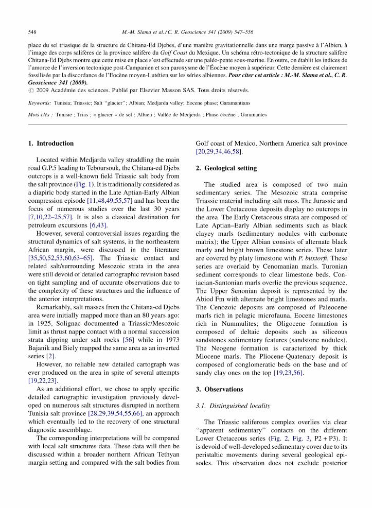
place du sel triasique de la structure de Chitana-Ed Djebes, d’une manière gravitationnelle dans une marge passive à l’Albien, àl’image des corps salifères de la province salifère du Golf Coast du Mexique. Un schéma rétro-tectonique de la structure salifèreChitana-Ed Djebs montre que cette mise en place s’est effectuée sur une paléo-pente sous-marine. En outre, on établit les indices del’amorce de l’inversion tectonique post-Campanien et son paroxysme de l’Éocène moyen à supérieur. Cette dernière est clairementfossilisée par la discordance de l’Eocène moyen-Lutétien sur les séries albiennes. Pour citer cet article : M.-M. Slama et al., C. R.Geoscience 341 (2009).# 2009 Académie des sciences. Publié par Elsevier Masson SAS. Tous droits réservés.
Keywords: Tunisia; Triassic; Salt ‘‘glacier’’; Albian; Medjarda valley; Eocene phase; Garamantians
Mots clés : Tunisie ; Trias ; « glacier » de sel ; Albien ; Vallée de Medjerda ; Phase éocène ; Garamantes
M.-M. Slama et al. / C. R. Geoscience 341 (2009) 547–556548
1. Introduction
Located within Medjarda valley straddling the mainroad G.P.5 leading to Teboursouk, the Chitana-ed Djebsoutcrops is a well-known field Triassic salt body fromthe salt province (Fig. 1). It is traditionally considered asa diapiric body started in the Late Aptian-Early Albiancompression episode [11,48,49,55,57] and has been thefocus of numerous studies over the last 30 years[7,10,22–25,57]. It is also a classical destination forpetroleum excursions [6,43].
However, several controversial issues regarding thestructural dynamics of salt systems, in the northeasternAfrican margin, were discussed in the literature[35,50,52,53,60,63–65]. The Triassic contact andrelated salt/surrounding Mesozoic strata in the areawere still devoid of detailed cartographic revision basedon tight sampling and of accurate observations due tothe complexity of these structures and the influence ofthe anterior interpretations.
Remarkably, salt masses from the Chitana-ed Djebsarea were initially mapped more than an 80 years ago:in 1925, Solignac documented a Triassic/Mesozoiclimit as thrust nappe contact with a normal successionstrata dipping under salt rocks [56] while in 1973Bajanik and Biely mapped the same area as an invertedseries [2].
However, no reliable new detailed cartograph wasever produced on the area in spite of several attempts[19,22,23].
As an additional effort, we chose to apply specificdetailed cartographic investigation previously devel-oped on numerous salt structures disrupted in northernTunisia salt province [28,29,39,54,55,66], an approachwhich eventually led to the recovery of one structuraldiagnostic assemblage.
The corresponding interpretations will be comparedwith local salt structures data. These data will then bediscussed within a broader northern African Tethyanmargin setting and compared with the salt bodies from
Golf coast of Mexico, Northern America salt province[20,29,34,46,58].
2. Geological setting
The studied area is composed of two mainsedimentary series. The Mesozoic strata compriseTriassic material including salt mass. The Jurassic andthe Lower Cretaceous deposits display no outcrops inthe area. The Early Cretaceous strata are composed ofLate Aptian–Early Albian sediments such as blackclayey marls (sedimentary nodules with carbonatematrix); the Upper Albian consists of alternate blackmarly and bright brown limestone series. These laterare covered by platy limestone with P. buxtorfi. Theseseries are overlaid by Cenomanian marls. Turoniansediment corresponds to clear limestone beds. Con-iacian-Santonian marls overlie the previous sequence.The Upper Senonian deposit is represented by theAbiod Fm with alternate bright limestones and marls.The Cenozoic deposits are composed of Paleocenemarls rich in pelagic microfauna, Eocene limestonesrich in Nummulites; the Oligocene formation iscomposed of deltaic deposits such as siliceoussandstones sedimentary features (sandstone nodules).The Neogene formation is caracterized by thickMiocene marls. The Pliocene-Quatenary deposit iscomposed of conglomeratic beds on the base and ofsandy clay ones on the top [19,23,56].
3. Observations
3.1. Distinguished locality
The Triassic saliferous complex overlies via clear‘‘apparent sedimentary’’ contacts on the differentLower Cretaceous series (Fig. 2, Fig. 3, P2 + P3). Itis devoid of well-developed sedimentary cover due to itsperistaltic movements during several geological epi-sodes. This observation does not exclude posterior

M.-M. Slama et al. / C. R. Geoscience 341 (2009) 547–556 549
Fig. 1. Summary sketch map of Triassic evaporites in northern Tunisia.
Fig. 1. Esquisse sommaire des affleurements triasiques du Nord de la Tunisie.
tectonic activity or salt movement in compressioncontext.
In the J. Tellet Mabrouka area (Fig. 3B), thiscomplex covers precisely a marly bed of Albian age asattested by a pelagic foraminiferal association amongwhich Ticinella primula.
Within the J. Sene Ed Jemel, the overburden consistsof Upper Albian (Vraconian) in which is observed aplaty limestone/marls alternation exhibiting slumps andseptaria as indicated by the association of Rotaliporaand the index microfossil Planomalina buxtorfi.
The same Triassic deposits are covered, through anerosional surface, by Cenomanian and/or Early Cam-panian deposits as confirmed by the association:Rotalipora greeborvensis and Rotalipora Cushmani/G. elevata, G. stuartiformis, G. buloides, G. arca andRosita fornicata. In addition into W. el Blidha, weexamine a clearly ‘‘apparent sedimentary’’ limit in asubstratum strata dipping under the salt rocks (Fig. 3A).
Inside W. el Begi fold (Fig. 3D, Fig. 4 X-X’), theTriassic rocks are included within the Late Aptian/Lower Albian and Late Albian formations and show,underneath and on top, tow originally ‘‘apparentsedimentary’’ limits. From southeast to northwest, wecheck up on the underside of the Triassic mass, theEarly Albian marls; the core of the fold is occupied byLate Aptian marls. Then the same salt mass is coveredby Late Albian marls via clearly ‘‘apparent sedimen-tary’’ contact. This succession was repeated because ofthe existence of transversal faults.
4. The Eocene phase clues
The North-East Moghrebian passive margin wasconsidered in a rifting regime during Aptian and EarlyAlbian times [9,10,12,18,28,31,32,41,61]. Its invertedbasins that were in compression regime began to form inthe transition between Lower and Upper Senonian

M.-M. Slama et al. / C. R. Geoscience 341 (2009) 547–556550
Fig. 2. Geological map of the study area.
Fig. 2. Carte géologique du secteur d’étude.
[15,32,40,61] and its paroxysmal event started in theMiddle–Late Eocene episode. This event is welldocumented in the North Moghrebian margin[3,15,21,26,27,30,37,40,44,61].
Within Jebel Chitana (Fig. 5Y, Fig. 4 Y-Y’) above thePaleocene marly levels and a conglomeratic bed asandstone bar is observed which is rich in glauconiteand phosphates. This bar is covered by the Ypresiancarbonates that are elongated in a NW–SE band forming
the major topographic altitude points in the area. Thesuccession is followed by massive Nummulites-richlimestone beds alternating with sandstone levels. Theselater show a metric thickness with shaly and marlyjoints intercalations; they bear Echinid remnants, smallNummulites specimens, Globigerina, Lepidocyclina,Globorotalia and Algae.Eastward of J. Chitana(Fig. 5Z), the cross-section shows from the base tothe top: Campanian-Maatrichtian carbonate displaying

M.-M. Slama et al. / C. R. Geoscience 341 (2009) 547–556 551
Fig. 3. The correlation panel across the area showing visible cross sections. 1: lower limit of the composite submarine salt ‘‘glacier’’ of Chitana-EdDjebs; 2: upper limit of the latter.
Fig. 3. Corrélation des coupes visibles. 1 : contacts inférieurs du matériel salifère triasique du « glacier de sel » sous-marin composite Chitana-EdDjebs ; 2 : contacts supérieurs de ce dernier.
planktonic microfaunal association that characterizesthe Abiod Formation. A polygenic conglomeratichorizon with an erosional surface separates thisFormation from the adjacent Eocene Nummulitescarbonates.
Inside W. Bou Kralfa (Fig. 5V, Fig. 4 Z-Z’), weobserve a 20 m-thick limestone succession withdisseminated chert nodules. These sediments weredated to the Albian. These later are covered by 1m-thickconglomeratic horizon. On these series lie the MiddleEocene–Early Lutetian limestones composed of Num-mulites, Rotalia, Discocyclines, glaucaunites andorganic remnants, as observed on thin-section. Thistransgressive Upper Eocene limestone overlay manyCretaceous deposits outcropping in the area.Thus, itappears that various Triassic rocks, Cretaceous strataand Palaeocene marls are unconformably overlain byMiddle Eocene-Early Lutetian limestones. This dis-cordance was observed also in the W. Bou Kralfa,J. Tellet Mabroka and J. Chitana outcrops (Fig. 5).
From east to west, the Oligocene lumachellicsandstone beds overlie, with a low angle unconformity,various substratums (from Triassic to Eocene). Thisdiscordance too is observed in several localities in thestudied area such as in the West of J. Sene ed Jemel on
Triassic rocks as well as on eastern edge of the W.Blidha anticline. Indeed, many authors have noticedthat [29,39,42,47,54,66].
5. Basin fault systems
The described Lower Cretaceous is either limited byN45, a left strike-slip often coexists with N130 LateQuaternary faults, which indicates a right lateralmovement [51]. These variations could be related topre-existing faults. These later control the thickness ofsedimentary deposits (Fig. 3, Fig. 4). The observedgeomorphologic features (offsets of valleys, etc.) testifyto the late oblique left-lateral strike-slip movement.Moreover, they reveal several evidences of instable seafloor, consequence of an extensive regime in theMesozoic subsidence episode. Nevertheless, the majorinherited Early Cretaceous extensional faults trendsN40-50, N 110-120 [8,13,28] and folds of this studiedarea show a N40E trend.
In the investigated area, inherited normal faults(I.N.F.) were the cause of the first Triassic salt extrusionN40-50 and N 110-120 trends. This later shows adisposition of tilted blocks developing first in UpperAptian [18,38]. The next major phase in the area was
M.-M. Slama et al. / C. R. Geoscience 341 (2009) 547–556552
Fig. 4. Geological cross-sections in the W. bou Kralfa, J. Chitana and W. El Begi.
Fig. 4. Coupes géologiques dans l’oued bou Kralfa, J. Chitana et oued. El Begi.
dated to the end of the Santonian time [32] marked bythe transgressive cycle of Early Campanian marlsbearing G. elevata, G.ventricosa, G. stuatiformis, onnumerous substratums as observed on the Triassic sheetof W. Bou Kralfa (Fig. 3 P3). We considered theincipient of the positive tectonic inversion approxi-mately at the transition between the Lower and UpperSenonian [40]: beginning of the true graben inversion.In fact, these structures were complicated by theTertiary folding.
The salt structure born in the graben basin has beensubjected to asymmetric thrusting, possibly enhancedby gravitational gliding due to: (1) the slight, LateEocene compression phase; (2) the latest salt stockcoming from the mother salt probably belonging to theOligocene episode. This later characterized by manyextensive features in outcrops (grainstones, septariasetc.); (3) the orientation of the major inherited normalfaults opposed to the direction of the principal oblique
compression (NW–SE) (for example, Fig. 3 and Plate 1of ref. [16]).
6. Interpretation
These updated biostratigraphic and observations dataconfirm the hypotheses of an interbeded Triassic materialas previously announced on field [8,28,39,42,66] and insubsurface study [4,5,36,61]. Within the southern part ofthe studied area, the evaporitic Triassic and red beds forma melange with only Early Albian limestone dippingunder the Triassic mass (Fig. 4). In addition, the evidenceof Paleocene exiguous scarps as well as the unconformityof Lower Eocene deposits on Albian strata attest thebottom instability during deposition.
The most spectacular discordance of the describedLower Eocene limestone is that of W. Bou Kralfa wherea gentil angle (about 208) with the adjacent Albianseries is observed (Fig. 4 Z-Z’, Fig. 5V, and Fig. 5 P1).

M.-M. Slama et al. / C. R. Geoscience 341 (2009) 547–556 553
Fig. 5. West–east correlation panel across the area showing the Middle Eocene–Early Lutetian deposits discordance on various substratums.
Fig. 5. Le panneau de corrélation oust–est à travers le secteur montrant la discordance de l’Éocène moyen–Lutétien inférieur sur diverssubstratums.
This unconformity fossilizes the beginning of the LateEocene folding followed by a regressive-transgressivecycle.
The collected data on regional scale as well as theNorth-African literature confirm these observations[17,27,37,39,44,66,68]. The extracted data from fieldstudy are included in the North Africa’s marginframework evolution [12,15,27,32,61].
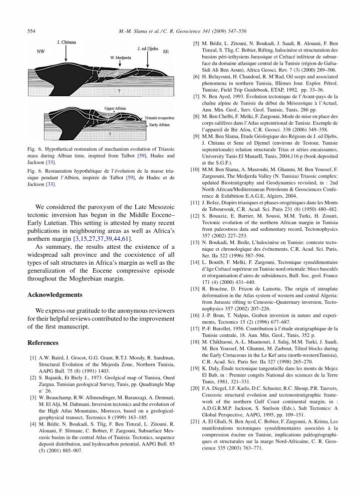
The updated data presented in this paper support aninterstratified Triassic salt in Albian time. Besides, theOligocene unconformity on the salt rocks does notcorrespond to erosional activity that affected theTriassic in its original position, to the Early Mesozoicbottom. After straightening the two Tertiary foldings,the Oligocene units do not allow one to find ‘‘anintrusive Triassic structure’’ rather than a ‘‘horizontal’’emplacement of salt mass.
Furthermore, the unconformity of Eocene depositson subjacent series excludes the thrust position of theTriassic complex. In addition, according to thestructural restoration of the Tertiary folding, weshowed the Middle Eocene–Early Lutetian limestonedeposed with a gentle angle (208) on the substratum ofthe Triassic mass (Fig. 5 P1). These observationsconfirm the salt ‘‘glacier’’ hypothesis rather than anintruded structure. During folding, salt rocks maytherefore be remobilized from extensional fracturing of
the overburden rather than from overall lateralcompression.
In fact, the Triassic salt rocks emplaced in Albiantimes over a previously marine slope, within a hot riftedsetting, following a scenario similar to those of theKebbouche, Ben Gasseur and Fej el Adoum salt‘‘glacier’’ (N. Tunisia) [1,4,5,14,18,29,62,66,67] aswell as a submarine salt ‘‘glacier’’ of Golf Coast ofMexico and Northern America [20,34,58,59].
7. Conclusion
The studied area, as for the neighbouring region, hasundergone a moderate ante-Oligocene compression, theinitiation of the Eocene phase [45].
The lower erosion contact Triassic/Albian and theTriassic variegated debris reworked by Albian lime-stone indicate that the lateral extrusion of the Triassicmaterial took place during the Albian in a shallowmarine environment on a gentle slope.
Our study suggests that the Chitana-J. Sene Ed Jemelarea is a submarine composite salt «glacier» extrudedduring Lower Albian and then laterally expandedrapidly till the Uppermost Albian (Vraconian) and the J.ed Djebs was considered as a simple salt «glacier»installed during Early Albian or an detached open toe ofsheet during overthrust episodes (Fig. 6).
M.-M. Slama et al. / C. R. Geoscience 341 (2009) 547–556554
Fig. 6. Hypothetical restoration of mechanism evolution of Triassicmass during Albian time, inspired from Talbot [59], Hudec andJackson [33].
Fig. 6. Restauration hypothétique de l’évolution de la masse tria-sique pendant l’Albien, inspirée de Talbot [59], de Hudec et deJackson [33].
We considered the paroxysm of the Late Mesozoictectonic inversion has begun in the Middle Eocene–
Early Lutetian. This setting is attested by many recentpublications in neighbouring areas as well as Africa’snorthern margin [3,15,27,37,39,44,61].
As summary, the results attest the existence of awidespread salt province and the coexistence of alltypes of salt structures in Africa’s margin as well as thegeneralization of the Eocene compressive episodethroughout the Moghrebian margin.
Acknowledgements
We express our gratitude to the anonymous reviewersfor their helpful reviews contributed to the improvementof the first manuscript.
References
[1] A.W. Baird, J. Grocot, G.G. Grant, R.T.J. Moody, R. Sandman,Structural Evolution of the Mejerda Zone, Northern Tunisia,AAPG Bull. 75 (8) (1991) 1403.
[2] S. Bajanik, Et Biely J., 1973. Geolgical map of Tunisia, OuedZargua. Tunisian geological Survey, Tunis, pp. Quadrangle Mapn8 26.
[3] W. Beauchamp, R.W. Allmendinger, M. Baranzagi, A. Demnati,M. El Alji, M. Dahmani, Inversion tectonics and the evolution ofthe High Atlas Mountains, Morocco, based on a geological-geophysical transect, Tectonics 8 (1999) 163–185.
[4] M. Bédir, N. Boukadi, S. Tlig, F. Ben Timzal, L. Zitouni, R.Alouani, F. Slimane, C. Bobier, F. Zargouni, Subsurface Mes-ozoic basins in the central Atlas of Tunisia: Tectonics, sequencedeposit distribution, and hydrocarbon potential, AAPG Bull. 85(5) (2001) 885–907.
[5] M. Bédir, L. Zitouni, N. Boukadi, J. Saadi, R. Alouani, F. BenTimzal, S. Tlig, C. Bobier, Rifting, halocinèse et structuration desbassins péri-tethysiens Jurassique et Crétacé inférieur de subsur-face du domaine atlasique central de la Tunisie (région de Gafsa-Sidi Ali Ben Aoun), Africa Geosci. Rev. 7 (3) (2000) 289–306.
[6] H. Belayouni, H. Chandoul, R. M’Rad, Oil seeps and associatedphenomena in northern Tunisia, IlIèmes Jour. Explor. Pétrol.Tunisie, Field Trip Guidebook, ETAP, 1992, pp. 33–36.
[7] N. Ben Ayed, 1993. Évolution tectonique de l’Avant-pays de lachaîne alpine de Tunisie du début du Mésozoïque à l’Actuel,Ann. Min. Geol., Serv. Geol. Tunisie, Tunis, 286 pp.
[8] M. Ben Chelbi, F. Melki, F. Zargouni, Mode de mise en place descorps salifères dans l’Atlas septentrional de Tunisie. Exemple del’appareil de Bir Afou, C.R. Geosci. 338 (2006) 349–358.
[9] M.M. Ben Slama, Etude Géologique des Régions de J. ed Djebs,J. Chitana et Sene ed Djemel (environs de Testour, Tunisieseptentrionale) relation structurale Trias et séries encaissantes,University Tunis El ManarII, Tunis, 2004,116 p (book depositedat the S.G.F.).
[10] M.M. Ben Slama, A. Masrouhi, M. Ghanmi, M. Ben Youssef, F.Zarguouni, The Medjerda Valley (N. Tunisia) Triassic complex:updated Biostratigraphy and Geodynamics revisited, in : 2ndNorth African/Mediterranean Petroleum & Geosciences Confe-rence & Exhibition E.A.G.E, Algiers, 2004.
[11] J. Bolze, Diapirs triasiques et phases orogéniques dans les Montsde Teboursouk, C.R. Acad. Sci. Paris 231 (8) (1950) 480–482.
[12] S. Bouaziz, E. Barrier, M. Soussi, M.M. Turki, H. Zouari,Tectonic evolution of the northern African margin in Tunisiafrom paleostress data and sedimentary record, Tectonophysics357 (2002) 227–253.
[13] N. Boukadi, M. Bedir, L’halocinèse en Tunisie: contexte tecto-nique et chronologique des événements, C.R. Acad. Sci. Paris,Ser. IIa 322 (1996) 587–594.
[14] L. Boutib, F. Melki, F. Zargouni, Tectonique synsédimentaired’âge Crétacé supérieur en Tunisie nord orientale: blocs basculéset réorganisation d’aires de subsidences, Bull. Soc. geol. France171 (4) (2000) 431–440.
[15] R. Bracène, D. Frizon de Lamotte, The origin of intraplatedeformation in the Atlas system of western and central Algeria:from Jurassic rifting to Cenozoic–Quaternary inversion, Tecto-nophysics 357 (2002) 207–226.
[16] J.-P. Brun, T. Nalpas, Graben inversion in nature and experi-ments, Tectonics 15 (2) (1996) 677–687.
[17] P.-F. Burollet, 1956. Contribution à l’étude stratigraphique de laTunisie centrale, 18. Ann. Min. Geol., Tunis, 352 p.
[18] M. Chikhaoui, A.-L. Maamouri, J. Salaj, M.M. Turki, J. Saadi,M. Ben Youssef, M. Ghanmi, M. Zarbout, Tilted blocks duringthe Early Cretaceous in the Le Kef area (north-westernTunisia),C.R. Acad. Sci. Paris Ser. IIa 327 (1998) 265–270.
[19] K. Daly, Étude tectonique tangentielle dans les monts de MejezEl Bab, in : Premier congrès National des sciences de la TerreTunis, 1981, 321–331.
[20] F.A. Diegel, J.F. Karlo, D.C. Schuster, R.C. Shoup, P.R. Tauvers,Cenozoic structural evolution and tectonostratigraphic frame-work of the northern Gulf Coast continental margin, in :A.D.G.R.M.P. Jackson, S. Snelson (Eds.), Salt Tectonics: AGlobal Perspective, AAPG, 1995, pp. 109–151.
[21] A. El Ghali, N. Ben Ayed, C. Bobier, F. Zargouni, A. Krima, Lesmanifestations tectoniques synsédimentaires associées à lacompression éocène en Tunisie, implications paléogéographi-ques et structurales sur la marge Nord-Africaine, C. R. Geos-cience 335 (2003) 763–771.

M.-M. Slama et al. / C. R. Geoscience 341 (2009) 547–556 555
[22] H. El Ouardi, Halocinèse et rôle des décrochements dansl’évolution géodynamique de la partie médiane de la zone desdômes, Univ. of El Manar II Tunis, 1996 242 p.
[23] H. El Ouardi, Origine des variations latérales des dépôts ypré-siens dans la zone des dômes en Tunisie septentrionale, C.R.Geoscience 334 (2002) 141–146.
[24] H. El Ouardi, M.-M. Turki, Tectonique salifère polyphasée dansla région de Mejez el Bab–Testour (zone des dômes, Tunisieseptentrionale): contrôle de la sédimentation méso-cénozoïque,Geol. Mediterr. 22 (2) (1995) 73–84.
[25] H. El Ouardi, M.-M. Turki, Discution sur l’âge et le cadrestructural de la sédimentation néogène dans la zone des dômesen Tunisie septentrionale, Geol. Mediterr. 27 (1) (2000) 47–55.
[26] D. Frizon De Lamotte, About the Cenozoic inversion of the Atlasdomain in North Africa, C. R. Geoscience 337 (2005) 475–476.
[27] D. Frizon De Lamotte, B. Saint Bezar, R. Barcene, E. Mercier,The two main steps of the Atlas building and geodynamics of thewestern Mediterranean, Tectonics 19 (4) (2000) 740–761.
[28] M. Ghanmi, Géodynamique de la plate-forme saharienne et de samarge septentrionale au Crétacé. Son évolution vers l’Atlasseptentrional, interférences du rifting et de l’halocinèse, Univ.Tunis El Manar II, Tunis, 2003, 347 p.
[29] M. Ghanmi, M. Ben Youssef, M. Jouirou, F. Zargouni, J.-M.Vila, Halocinèse crétacée au Jebel Kebbouch (Nord-Ouest tuni-sien): mise en place à fleur d’eau et évolution d’un « glacier desel » albien, comparaisons, Eclog. Geol. Helv. 94 (2001) 153–
160.[30] R. Guiraud, Évolution post-triasique de l’avant-pays de la chaîne
alpine en Algérie, d’après l’étude du bassin du Hodna et desrégions voisines, Univ. Nice, Nice, 1973, 270 p.
[31] R. Guiraud, in : D.S. Macgregor, R.T.J. Moody, D.D. Clark-Lowes(Eds.), Mesozoic rifting and basin inversion along the northernAfrican Tethyan margin: an overview, Petroleum Geology ofNorth Africa Geological Society, London, 1998, pp. 217–229.
[32] R. Guiraud, W. Boswrth, Senonian basin inversion and rejuve-nation of rifting in Africa and Arabia: synthesis and implicationsto plate-scale tectonics, Tectonophysics 282 (1997) 39–82.
[33] M.R. Hudec, M.P.A. Jackson, Advance of allochthonous saltsheets in passive margins and orogens, AAPG 90 (2006) 1535–
1564.[34] M.P.A. Jackson, J.C. Harrison, An allochthonous salt canopy on
Axel Heiberg Island, Sverdrup Basin, Arct. Canada Geol. 34(2006) 1045–1048.
[35] C. Jallouli, M. Chikhaoui, A. Braham, M-.M. Turki, K. Mickus,R. Benassi, Reply to the discussion by C.J. Talbot on ‘‘Evidencefor Triassic salt domes in the Tunisian Atlas from gravity andgeological data’’ by C. Jallouli et al.,[Tectonophysics 396 (2005)209-225], Tectonophysics 406 (2005) 249–254.
[36] A. Jlailia, A. Maazaoui, Opportunities for Hydrocarbon potentialin the Deep Objectives Sub-salt Plays; Not-Explored in TunisiaCase Studies: Triassic & Jurassic Reservoirs Exploring deeptargets & new areas for more reserves, E.T.A.P, in : The 10thTunisian Petroleum Exploraton & Production, Tunis, 2006.
[37] S. Khomsi, M. Bédir, M. Soussi, G.-M. Ben Jemia, K. BenIsmail-Lattrache, Mise en évidence en subsurface d’événementscompressifs Éocène moyen–supérieur en Tunisie orientale(Sahel): généralité de la phase atlasique en Afrique du Nord,C.R. Geoscience 338 (2006) 41–49.
[38] M.F. Ladeb, J.-C. Horrenberger, Y. Cailleux, F. Zargouni, Struc-tures mésoscopiques associées à la distension aptienne en Tuni-sie centrale (dj. Semmama), C. R. Acad. Sci. Paris, Ser. IIa 321(1995) 333–338.
[39] A. Masrouhi, Les appareils salifères des régions de Mateur,Tébourba et de Medjez-el-Bab (Tunisie du Nord), Univ. Tunis elManar II, Tunis, 2006, 258 p.
[40] A. Masrouhi, M. Ghanmi, M.-M. Ben Slama, M. Ben Youssef, J.-M. Vila, F. Zargouni, New tectono-sedimentary evidence cons-training the timing of the positive tectonic inversion and theEocene Atlasic phase in northern Tunisia: Implication for theNorth African paleo-margin evolution, C. R. Geoscience 340(2008) 771–778.
[41] A. Masrouhi, M. Ghanmi, M. Ben Youssef, J.-M. Vila, F.Zargouni, Mise en évidence d’une nappe de charriage à deuxunités paléogènes au plateau de Lansarine (Tunisie du nord):définition d’un nouvel élément structural de l’Atlas tunisien etréévaluation du calendrier des serrages tertiaires, C. R. Geos-cience 339 (2007) 441–448.
[42] A. Masrouhi, M. Ghanmi, M. Ben Youssef, F. Zargouni, J.-M.Vila, Mise en évidence d’un dais de sel (Salt Canopy) au JebelLansarine (Tunisie du Nord): implication sur la diversité desAppareils salifères de la marge passive du Nord-Est du Maghreb,in : 3 ème Séminaire National de Stratigraphie, Laghouat,Algérie, 2007.
[43] R. Moody, A. Brown, B. Loucks, Programme and Field Loca-lities, in : J. Grocott, R. Moody, A. Brown, R. Loucks (Eds.),Tertiary to Recent Larger Foraminifera: Their DepositionalEnvironments and Importance as Petroleum Reservoirs: Field-trip: February 19–24th, 1998 Central and North-West Tunisia,ARCO-BG plc-Carthago oil- Cheveron, Tunis, 1998, p. 84.
[44] H. Mzali, H. Zouari, Caractérisation géométrique et cinématiquedes structures liées aux phases compressives de l’Éocène auQuaternaire inférieur en Tunisie: exemple de la Tunisie nord-orientale, C.R. Geoscience 338 (2006) 742–749.
[45] M.-A. Ould Bagga, S. Abdeljaoued, E. Mercier, La « zone desnappes » de Tunisie, une marge méso-cénozoïque en blocsbasculés modérément inversée (région de Taberka/Jendouba;Tunisie nord-occidentale), Bull. Soc. geol. France 177 (3)(2006) 145–154.
[46] F.J. Peel, C.J. Travis, J.R. Hossack, Genetic structural provincesand salt tectonics of the Cenozoic offshore U.S. Gulf of Mexico:A preliminary analysis, in : D.G.R.M.P.A. Jackson, S. Snelson(Eds.), Salt Tectonics: A Global Perspective, AAPG, 1995, pp.153–175.
[47] V. Perthuisot, Dynamique et Pétrogenèse des Extrusions Tria-siques en Tunisie Septentrionale, École Normale SupérieureParis, Paris, 1978, 312 p.
[48] V. Perthuisot, Diapirism in northern Tunisia, J. Struct. Geol. 3 (3)(1981) 231–235.
[49] V. Perthuisot, A. Bouzenoune, N. Hatira, B. Henry, E. Laatar, A.Mansouri, H. Rouvier, A. Smati, J. Thibiéroz, Les diapirs duMaghreb oriental: part des déformations alpines est des structu-res initiales crétacées et éocènes dans les formes actuelles, Bull.Soc. geol. France 170 (1) (1999) 57–65.
[50] V. Perthuisot, H. Rouvier, A. Bouzenoune, N. Hatira, B. Henry,M. Aoudjehane, E. Laatar, M. Le Goff, A. Mansouri, A. Smati, J.Thibiéroz, Réponse aux commentaires de Vila et al, Bull. Soc.geol. France 170 (3) (1999) 420.
[51] S. Rebaï, Recent tectonics in Northern Tunisia: coexistence ofcompressive and extensional structures, Ann. Tecton. VII (2)(1993) 129–141.
[52] H. Rouvier, B. Henry, M. Le Goff, 1999. Réponse à la note deJean-Marie Vila, Mohamed Ben Youssef, Salah Bouhlel, Moha-med Ghanmi, Fekri Kamoun, Bernard Peybernès « Le paléo-magnéisme est-il un meilleur outil que la biostratigraphie et la
M.-M. Slama et al. / C. R. Geoscience 341 (2009) 547–556556
sédimentologie pour fixer la polarité de I’Albien du Nord-Ouesttunisien ? » C. R. Acad. Sci. Paris, Ser. IIa 32 (1999) pp. 219–
226. C. R.Acad. Sci. Paris Ser. IIa 329 (1999) 845–846.[53] H. Rouvier, B. Henry, M. Le Goff, A. Smati, N. Hatira, A.
Mansouri, E. Laatar, J. Thibiéroz, V. Perthuisot, 1999. Commen-taire à la note de Jean-Marie Vila, Mohamed Ben Youssef, SalahBouhlel, Mohamed Ghanmi, Samia Kassai et Fethi Miaadi« Tectonique en radeaux au toit d’un « glacier de Sel » sous-marin albien de Tunisie du Nord-Ouest: exemple du secteurminier de Gueurn Halfaya », C. R. Acad. Paris Ser. IIa 327(1998) 563–570, C. R.Acad. Sci. Paris Ser. IIa 328 (1999) 565–
566.[54] P. Sainfeld, Les gites plombo-zincifères de Tunisie, Ann. Min.
Geol., Tunis, 1952, 285 p.[55] W. Snoke, S. Schamel, R.M. Karasek, Structural evolution of
Djebel Debadib anticline: A clue to the regional tectonic style ofthe Tunisian Atlas, Tectonics 7 (3) (1988) 497–516.
[56] M. Solignac, Les recherches de pétrole en Tunisie, Rev. Petrol,Paris, 1925, 59 pp.
[57] M. Solignac, Etude géologique de la Tunisie septentrionale,Serv. Mines Dir. Gén. Trav. Publ., Tunis, 1927, 756 p.
[58] J. Steven, W. John, A New Conceptual Model for Scotian MarginSalt detachment on the Northeast Scotian margin,offshore eas-tern Canada, AAPG Bull. 90 (2006) 1407–1423.
[59] C.J. Talbot, Spreading of salt structures in the Gulf of Mexico,Tectonophysics 228 (1993) 151–166.
[60] C.J. Talbot, Discussion on ‘‘Evidence for Triassic salt domes inthe Tunisian Atlas from gravity and geological data’’ by C.Jallouli et al, Tectonophysics 396 (2005) 209–225, Tectono-physics, 406 (2005) 249–254.
[61] R. Vially, J. Letouzey, F. Benard, N. Haddadi, G. Desforges, H.Askri, A. Boudjema, Basin inversion along the North-AfricanMargin the Saharan Atlas (Algeria), in : F. Roure (Ed.), Peri-tethyan Platforms, Technip Edition, Paris, 1994, pp. 79–118.
[62] J.M. Vila, M. Ben Youssef, M. Chikhaoui, M. Ghanmi, Deu-xième étude de surface d’un grand « glacier de sel » sous-marinalbien (250 km2 ?) : les masses triasiques du « diapir » de Ben
Gasseur et de l’anticlinal du Kef (Nord-Ouest tunisien), Bull.Soc. geol. France 167 (1996) 235–246.
[63] J.-M. Vila, Ben Youssef, M., Bouhlel, S., Charrière, A., Chik-haoui, M., Dali, T., Ghanmi, M., Kamoun, F., Kassaa, S., Kechid-Benkherouf, F., Saadi, J., Sami, L., Souquet, P., Peybernes, B.Commentaire sur la note de V. Perthuisot et al. : « Les corpstriasiques des monts du Mellègue (confins algérotunisiens) sont-ils des diapirs ou des « glaciers de sel ? », Bull. Soc. Geol.France, 169 (1998) 53–61. Bull. Soc. Geol. France 170 (3)(1999)413–419.
[64] J.-M. Vila, M. Ben Youssef, S. Bouhlel, M. Ghanmi, F. Kamoun,B. Peybernès, Is palaeomagnetism a better tool than biostrati-grapby and sedimentology to define the polarity of the Albiandeposits from northwestern Tunisia? C. R. Acad. Sci. Paris Ser.IIa 329 (1999) 219–226.
[65] J.-M. Vila, M. Ben Youssef, S. Bouhlel, M. Ghanmi, S. Kassaa,F. Miaadi, Réponse aux commentaires de H. Rouvier et al. à lanote « Tectonique en radeaux au toit d’un « glacier de sel » sous-marin albien de Tunisie du Nord Ouest : exemple du secteurminier de Gueurn Halfaya », C.R. Acad. Sci. Paris Ser. IIa 327(1998) 563–570, 328 (1999) 567-568.
[66] J.-M. Vila, M. Ghanmi, M. Ben Youssef, M. Jouirou, Les‘‘glaciers de sel’’ sous-marins des marges continentales passivesdu nord-est du Maghreb (Algérie-Tunisie) et de la Gulf Coast(USA) : comparaisons, nouveau regard sur les « glaciers de sel »composites, illustré par celui de Fedj el Adoum (Nord-Ouesttunisien) et revue globale, Eclog. Geol. Helv. 95 (2002) 347–380.
[67] J.-M. Vila, S. Kassaa, S. Bouhlel, M. Ben Youssef, T. Dali, M.Ghanmi, Inversion tectonique de structures halocinétiques etlocalisation des minéralisations (Zn, Sr) : émergence au JebelBou Khil (Nord-Ouest tunisien) d’un chevauchement entre undomaine nord à «glaciers de sel» sous-marins et un domaine sudà « diapirs typiques », Bull. Soc. geol. France 170 (2) (1999)161–172.
[68] F. Zargouni, Etude des mouvements ascensionnels du complexetriasique dans la chaîne de Lansarine (Atlas Tunisien-Zone des‘‘Diapirs’’, Notes Serv. Geol. Tunisie 43 (1977) 13–21.