technology’s stories island is called talpatty in bangladesh and new moore in india. ... landscape...
TRANSCRIPT
Technology’s Stories June 2016
Bhattacharyya/ 1
Manufactured Landscapes: Law and Hydraulics in the Bengal
Delta Debjani Bhattacharyya DOI: 10.15763/JOU.TS.2016.6.1.01
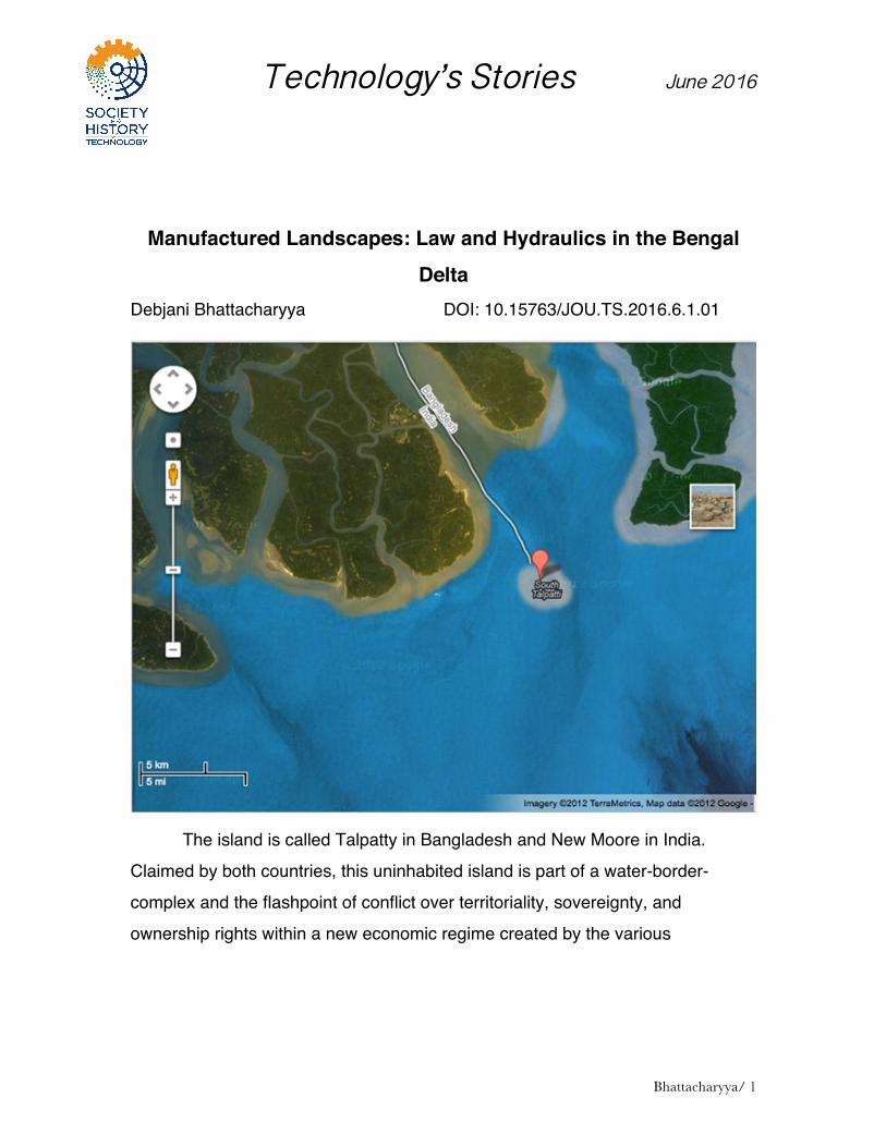
The island is called Talpatty in Bangladesh and New Moore in India.
Claimed by both countries, this uninhabited island is part of a water-border-
complex and the flashpoint of conflict over territoriality, sovereignty, and
ownership rights within a new economic regime created by the various

Bhattacharya – Manufactured Landscapes
2
2
continental shelf enactments of the past decades.1 This land-sea-scape was
formed initially by gradual deposition of silt from the various inlands rivers in the
region. A cyclone in 1970 precipitated this fluvial mix as the geographical entity of
an island. This was just one year before the nation-state of Bangladesh was
born. This island measures between two to twelve square kilometers depending
on the season, rainfall and the tides in the Bay of Bengal.
While both the nations lock horns, sign multiple treaties and successively
violate them, fishermen from the neighboring areas often drift into this zone of
conflict. Fishermen, like the silt and alluvium in the area, challenge the idea of
boundaries. While cross-border tensions remain unabated, the island continues
to disappear as sea-levels rise, eroding and remaking the landscape of the delta.
This is not something new or unique to the Bay of Bengal. Landmasses in bays
and coastal areas have a different relation with water;2 the landmass flows,
moves, and challenges the fixities of cartography, ownership and territorial
sovereignty. In the case of Talpatty/New Moore Island perhaps the rising seas
will solve the cross-border conflict of ownership. But the mobility that defines
land-water relation in this region has a long and complicated history.
Talpatty Islands makes us aware of the “aquatic reality” of land and its
possession.3 It also attunes us to the fact that the temporality of land as fixed and
cartographic, is just one among many. However, it is idea of land as fixed and
immobile, rather than moving and seasonal that has been woven into our
histories of property, law, and design.
Yet, spaces like Talpatty are what I call temporary landscapes, often also
known as char or diara in the region. They are mere moments in the flow of water
in a tidal basin. Such moments manifest themselves geographically either as 1 Salman M.A. Salman and Kishor Uprety, Conflict and Cooperation on South Asia’s International Rivers: A Legal Perspective (The Hague: Kluwer Law International, 2002). 2 Ari Kelman, A River and its City: Nature and Landscape in New Orleans (University of California Press, 2006). 3 Gaston Bachelard, Water and Dreams: An Essay in the Imagination of Matter
(Dallas Institute of Humanities, 1999 repr.).

Bhattacharya – Manufactured Landscapes
3
3
seasonal sedimentations, or sometimes might have a decade-long existence, but
chars by nature are not fixed land, and they can move as much as seventy-seven
miles from year to year.4 The temporariness and flux within the landscape
challenge the permanence that bolsters our thinking around law, market and
design.
How do I define and demarcate this space of sedimentation – of silt and
time? This space stretches from the tip of the Bay of Bengal, also known as
Sagar Islands where the early mercantile ships of the monsoon traders from
Europe were docked to the city of Calcutta, which grew to become the second
capital of the British empire.This envirotechnical space is a veritable “water-
machine,” in an increasingly fortified landscape.5 Yet, unlike other envirotechnical
spaces, it is a landscape that has resisted and often overwhelmed hydraulic
engineering and fortification technologies, sometimes dramatically, and at other
times slowly.6
Thus the historical ecology of this aqueous landscape is uncovered by
cutting vertically into a century of deposition, revealing the layers of infrastructure
“thick with power,” politics, bureaucracy, speculation, legal maneuvering and
cultural practices.7 4 Stephen Kiernan and James Timberlake, Alluvium: Dhaka, Bangladesh in the
Crossroads of Water (ORE, 2015), 262; see also Kuntala Lahiri Dutt and Gopa Samanta, Dancing with the River: People and Life in the Chars of South Asia, (Yale University Press, 2013).
5 Sara Pritchard, Confluence: The Nature and Technology in the Remaking of the Rhone Valley (Harvard University Press, 2011); for work on technological remaking and state-building in India see Christopher V. Hill, River of Sorrow: Environment and Social Control in Riparian North India, 1770-1994 (Michigan: Association for Asian Studies, 1997); David Mosse, The Rule of Water: Statecraft, Ecology and Collective Action in South India (New Delhi: Oxford University Press, 2003). I borrow the term water machine from Anthony Acciavetti’s recent work Ganges Water Machine: Designing New India’s Ancient River, (Applied Research Design, 2015).
6 Rohan D’Souza, Drowned and Dammed: Colonial Capitalism and Flood Control in Eastern India (Oxford: Oxford University Press, 2006).
7 Wiebe E. Bijker, “Dikes and Dams, Thick with Politics,” ISIS, vol. 98, No. 1(March 2007):109-123.
Bhattacharya – Manufactured Landscapes
4
4
Indeed, from the 19th century onwards vast amounts of bureaucratic ink have
been spilled in efforts to map this landscape and its seasonal rivers, spill
channels, freshes or those spaces that became soaked in water annually.8 This
technology story focuses one of these aspects, namely on how the bureaucratic
labor of law had a significant role to play in manufacturing this landscape.
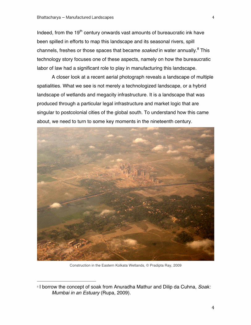
A closer look at a recent aerial photograph reveals a landscape of multiple
spatialities. What we see is not merely a technologized landscape, or a hybrid
landscape of wetlands and megacity infrastructure. It is a landscape that was
produced through a particular legal infrastructure and market logic that are
singular to postcolonial cities of the global south. To understand how this came
about, we need to turn to some key moments in the nineteenth century.
Construction in the Eastern Kolkata Wetlands, © Pradipta Ray, 2009
8 I borrow the concept of soak from Anuradha Mathur and Dilip da Cuhna, Soak:
Mumbai in an Estuary (Rupa, 2009).

Bhattacharya – Manufactured Landscapes
5
5
II. Limiting the Fluid City Around 1804-5 the river Hughli started changing in its course as it flowed
to the Bay of Bengal. By the 1820s, the Hughli had meandered so far west that it
had deposited alluvial land approximately four miles long and roughly half a mile
wide along the western banks of Calcutta. The fickle river had rendered irrelevant
the existing forms of land and ground measurements conducted in 1797 by the
East India Company upon the newly acquired land.
The movement of the river resulted in a spate of surveys and protracted
legal and municipal debates about property rights over the newly formed space
from the 1820s.9 This was a period when the city’s urban land tenure was in a
flux, and the indigenous residents refused to recognize the Company’s authority
to collect taxes. The emergence of the new strip of land opened up a discussion
of property rights upon that space and a larger debate about the East India
Company’s ownership status within colonial Bengal.
Following the shifts in the course of the river, the Conservancy
Department of the Justices of the Peace was charged with the responsibility for
technologically separating the land from water and fortifying the marshes into a
recognizable geographical formation – the riverbank. The fortification of the land
gave impetus to carrying out a survey of the riverbank which was conducted by
the Territories Department in 1820 in order to ascertain which part of the ground
along the river could be considered the property of the Company.10 The
Territories Department recommended improvements in the riverbank area by
establishing a Strand Bank Fund to raise money to improve the river bank, which
would also be named the Strand Road. However, a functioning Strand Bank
Fund was not established until 1837, a full seventeen years after this initial
recommendation. Through the efforts of the Strand Bank Fund, the Territories 9 Magistrate to Direct their Surveyors to Survey and Report on the Bank of the
River mentioned by the Mint Master, Fort William. Judicial [Criminal], June 25 1807, Prog. 1, WBSA, Kolkata.
10 Extract of the Territories Department, 1 April 1820, Judicial [Criminal], Prog. 15, WBSA, Kolkata
Bhattacharya – Manufactured Landscapes
6
6
Department gradually secured the appropriation of riverfront lands from wealthy
Indians and British residents for beautification, trade and warehouse purposes.11
No residents with property along the riverbank were ready to give up their land to
the Company without a fight.
This was when a new fiction of law, deploying novel technologies of
legitimation, was generated to render previous authority and claims to the land
along the riverbank fictitious. The legal battles precipitated by land acquisition
were a clash of two narrative genres attesting to two forms of authority. An
analysis of some of these long overlooked property disputes over the newly
formed land reveals that a new language of legality possession was forged.12
In 1820 Esq. Holt Mackenzie, Secretary to the Territorial Department
conducted the first survey of the riverbank and the newly formed land in order to
assess the extent and potential appropriation of this newly formed ground which
the government could then claim as its property. As a governing document or a
“graphic-artifact,”13 this Territories Department Report mediated and transformed
many social relations into political and economic contracts, and became a
significant part of the nineteenth-century social life of the city.
The Report stressed that, in Calcutta, the Company had the double right
of both the Sovereign and the Zamindar, and therefore it harnessed the laws of
the sovereign alongside the established custom. Mackenzie stressed throughout
the Report that “[t]he company is the general Zamindar [landlord] and as such
any new lands must, we conceive, be considered at its disposal.”14 Apart from
collapsing the role of the state and market into the corporate body of the joint
11 Strand Bank Funds, Judicial [Judicial], 10 October 1963, Prog. 123-131,
WBSA, Kolkata. 12 Extract form the Proceedings of the Territories Department, Judicial [Criminal],
1 April 1820, Prog. 15, WBSA, Kolkata. 13 I am borrowing this concept from Mathew S. Hull, Government of Paper: The
Materiality of Bureaucracy in Urban Pakistan (Berkley: University of California Press, 2012).
14 Extract of the Territories Department, 1 April 1820, Judicial [Criminal], Prog. 15 § 48, WBSA, Kolkata.

Bhattacharya – Manufactured Landscapes
7
7
stock company, it also laid down a legal regime for acquiring land without any
juridical justification.
Through multiple bureaucratic maneuvers, the colonial officials
transformed a geographically indeterminate and communally heterogeneous
space into clearly demarcated “public” space to be used under Company
stipulations. The translation of this water-land admixture into Company property
within law was coterminous with the production of a market in land. The Report
further mentioned that, although the government stood to accrue a considerable
amount of revenue from this, the immediate pecuniary gain was hardly the
driving force behind the Strand Bank project. Rather impulses much larger than
mere pecuniary gains were at work here. Indeed, the economic basis of colonial
legal production of spaces becomes apparent through an analysis of this
process.
The Territories Department Report provides compelling evidence for the
frustration encountered in attempts at mapping in the face of the moving river.
The major thrust of the Report was to acquire lands which the Territories
Department found to be in excess of any previous documentation, or spaces
where inhabitants could not produce any “recognizable” land-titles. Whenever
residents, mostly native, but sometimes also Europeans, failed to supply the
surveyors with paper documentation, the officials declared their possession to be
of a "dubious sort of occupancy" and dismissed their claims. The Report
prescribed an arbitrary provision for applying to have the extra land counted as
part of existing ownership. However, by a sleight of hand, it stipulated that papers
legitimizing ownership must be produced to justify claims upon the newly
emergent land. Finally, it foreclosed even that ludicrous provision in the next
sentence by saying that, in spite of any legitimate claim one may produce, the
“state” may decide to take over the land or refuse granting rights to it. Through
these bureaucratic maneuvers, merchants of a joint stock company turned
themselves into landlords and laid the “legal” groundwork for land acquisition in
the colony.

Bhattacharya – Manufactured Landscapes
8
8
Two decisive aspects of colonial law and economy converge here: On the
one hand, there was the attempt by the Company agents to initiate a process
whereby a heterogeneous body of ownership practices was condensed into
contractual paper-based exchange and establishment of rights. On the other
hand, the slippage between the terms interchangeably used in the Report point
to the operation of colonial power as corporate sovereignty — just as the
Company becomes the Zamindar (landlord) in the course of the report, it
eventually becomes the Government and finally the State. This deliberate
slippage throws light upon the unique political power of the Company-State with
the authority to deploy expansive legal powers to acquire land that they could
claim to be in excess of any recorded deeds. Within five years of the publication
of the report two new landmark regulations were enacted: one was the land
acquisition law for infrastructural development, and another that created a new
legal taxonomy to render this landscape legible to the British bureaucrats. A law
to adjudicate disputes about what now came to be known as “accreted and
derelicted land.” With this new legal terminology, the Company bureaucrats
eclipsed a rich ecological life world. It simultaneously laid the groundwork for a
thriving market in urban property in colonial Calcutta and infrastructural
expansion that did not take into account the unique geography of the active delta.
V. Concluding Remarks: Muddying Property Deltaic ecology is one that is dynamic, one where sedimentation and
erosion co-exist. Therefore, it is not surprising that there are seven ways to
describe erosion in Bengali, which signals a dynamic and complex relation
between land and water, that fortified geography of property cannot encapsulate.
The formation of the fixed Strand Road became a manifestation of imperial
infrastructure and consolidation of the colonial administrative town of Calcutta. As
a public space for the growth of trade and commerce it restructured the real
estate market. Thus, today the urban landscape at the edge of the delta is

Bhattacharya – Manufactured Landscapes
9
9
completely cut off from its watery history. When water appears, it comes as a
violation, as a destructive force that destroys property and livelihood.
The dynamic landscape, which was critical to the founding of the second
capital of the British empire ultimately became a “collage of disconnected fluvial
events that were regulated principally as practices of political economy.”15 The
legal creation of a margin between land and water so as to adjudicate property
disputes and acquire more land also produced the natural formations of an active
delta as "ecologically" unstable. The delta had to be managed through law and
fixed through a market in urban property. The management of the delta, which
resulted in the construction boom, is intricately linked with the rapidly vanishing
coastline of the Bengal delta.
The current urban landscape in this tidal delta comprising Dhaka,
Calcutta, Diamond Harbour, Sandeep Islands, and Canning, to name a few,
seem remotely connected to the delta, if at all. The only way water figures in
these spaces now is as disaster, flood, inundation, disappearing coastline or
waterlogging. An antithetical relationship of dry culture emerged not just through
infrastructural projects but also through a particular reality that law created in this
space.16 The implications of this dry culture are manifold and they manifest
themselves economically, ecologically and legally. This particular arrangement is
what I am calling the manufacturing of the hydrological landscape. This
manufacturing did not merely entail consolidation of the land and water-scape as
various forms of privatized landholding. It also involved abstraction of various
judicial and legal fictions of ownership, as well as of things “apparently
inaccessible to private appropriation (private property): nature, the earth, life
15 Rohan D’Souza, ‘Seeing Like a River: The Bengal Presidency’s Hydraulic
Transition’, in Arun Bandopadhyay (ed.), Science and Society in India 1750-2000 (Manohar: New Delhi, 2010), 174.
16 For an elaboration of the concept of law and the particular social reality it creates see my “History of Eminent Domain in Colonial Thought and Legal Practice,” Economic and Political Weekly, 50, no. 50 (December 2015), 45-53.
Bhattacharya – Manufactured Landscapes
10
10
energies, desires and needs.”17 The infrastructural refashioning and hydro-
engineering of the landscape continues even today. Calcutta’s new satellite town,
full of high-end real-estate shopping etc. is being built by filling up ecologically
critical wetlands in this area. This is not unique to Calcutta, but is taking place
also in Dhaka and the other smaller towns in the area. These cities are
threatened to gradually disappear as the current real estate expansion gobbles
up the wetlands, marshes and floodplains that protect their existence in the first
place. Is this not perhaps another hubris of the property regime that chooses not
remember or know how to live with marshes and water bodies around it?
Bibliography Primary Sources: Magistrate to Direct their Surveyors to Survey and Report on the Bank of the
River mentioned by the Mint Master, Fort William. Judicial [Criminal], June 25 1807, Prog. 1, WBSA, Kolkata.
Extract of the Territories Department, 1 April 1820, Judicial [Criminal], Prog. 15, WBSA, Kolkata.
Strand Bank Funds, Judicial [Judicial], 10 October 1963, Prog. 123-131, WBSA, Kolkata.
Secondary Sources: Acciavetti, Anthony. Ganges Water Machine: Designing New India’s Ancient
River, (Applied Research Design, 2015). Bachelard, Gaston. Water and Dreams: An Essay in the Imagination of Matter
(Dallas Institute of Humanities, 1999 repr.). Bhattacharyya, Debjani. “History of Eminent Domain in Colonial Thought and
Legal Practice,” Economic and Political Weekly, 50, no. 50 (December 2015), 45-53.
Bijker, Wiebe E. “Dikes and Dams, Thick with Politics,” ISIS, vol. 98, No. 1(March 2007):109-123.
D’Souza,Rohan Drowned and Dammed: Colonial Capitalism and Flood Control in Eastern India (Oxford: Oxford University Press, 2006).
___________. ‘Seeing Like a River: The Bengal Presidency’s Hydraulic Transition’, in Arun Bandopadhyay (ed.), Science and Society in India 1750-2000 (Manohar: New Delhi, 2010).
Hill, Christopher V. River of Sorrow: Environment and Social Control in Riparian North India, 1770-1994 (Michigan: Association for Asian Studies, 1997).
17 Henri Lefevbre, Production of Space (London: Wiley Blackwell,1991), 350.

Bhattacharya – Manufactured Landscapes
11
11
Hull, Mathew S. Government of Paper: The Materiality of Bureaucracy in Urban Pakistan (Berkley: University of California Press, 2012).
Kelman, Ari. A River and its City: Nature and Landscape in New Orleans (University of California Press, 2006).
Kiernan, Stephen and James Timberlake. Alluvium: Dhaka, Bangladesh in the Crossroads of Water (ORE, 2015).
Lahiri-Dutt, Kuntala and Gopa Samanta, Dancing with the River: People and Life in the Chars of South Asia, (Yale University Press, 2013).
Lefevbre, Henri. Production of Space (London: Wiley Blackwell,1991). Mathur, Anuradha and Dilip da Cuhna, Soak: Mumbai in an Estuary (Rupa,
2009). Mosse, David. The Rule of Water: Statecraft, Ecology and Collective Action in
South India (New Delhi: Oxford University Press, 2003). Pritchard, Sara Confluence: The Nature and Technology in the Remaking of the
Rhone Valley (Harvard University Press, 2011). Salman, M.A. Salman and Kishor Uprety, Conflict and Cooperation on South
Asia’s International Rivers: A Legal Perspective (The Hague: Kluwer Law International, 2002).