technology demonstration - nc
TRANSCRIPT

• Introductions
• Why Obliques matter and how they differ from traditional aerial Imagery
• Uses in Reassessment
• Integrations
• Case Studies
• Questions
Agenda

Area-wide Capture (5 way viewing)
Many overlapping images make tens of millions of overlapping geo-
referenced pixels
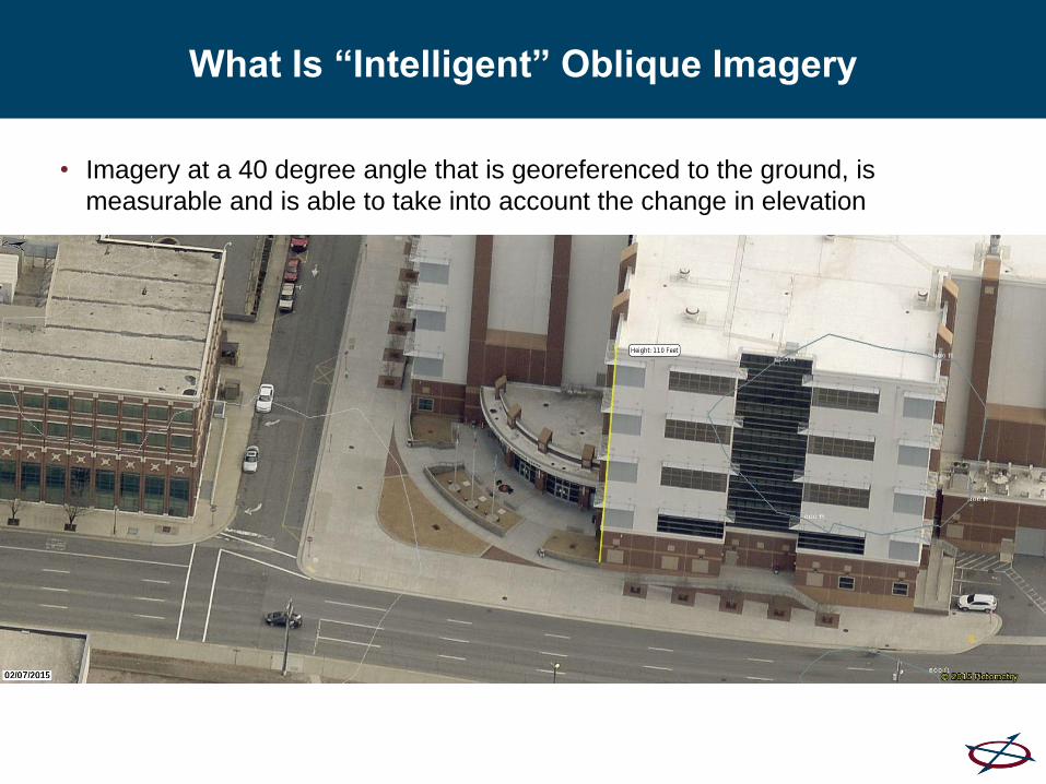
What Is “Intelligent” Oblique Imagery
• Imagery at a 40 degree angle that is georeferenced to the ground, is
measurable and is able to take into account the change in elevation

Why Are Obliques Are Important?
• Let’s play a game and find out


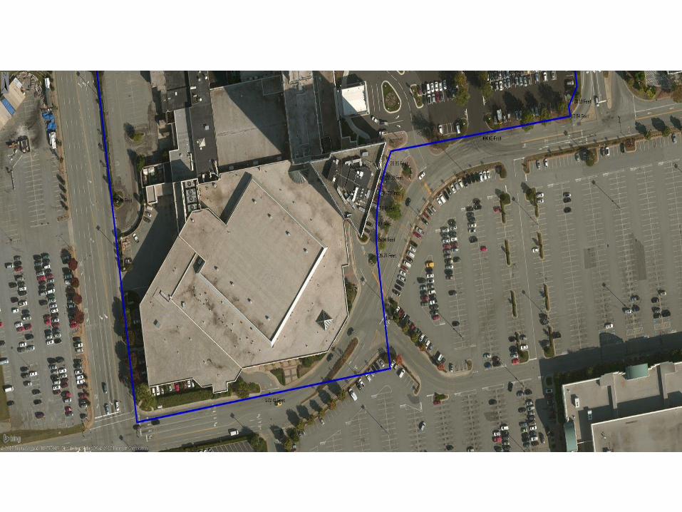


Standard Ortho Image
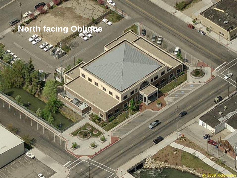
North facing Oblique

East facing Oblique
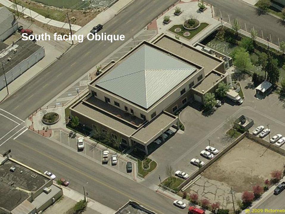
South facing Oblique

West facing Oblique
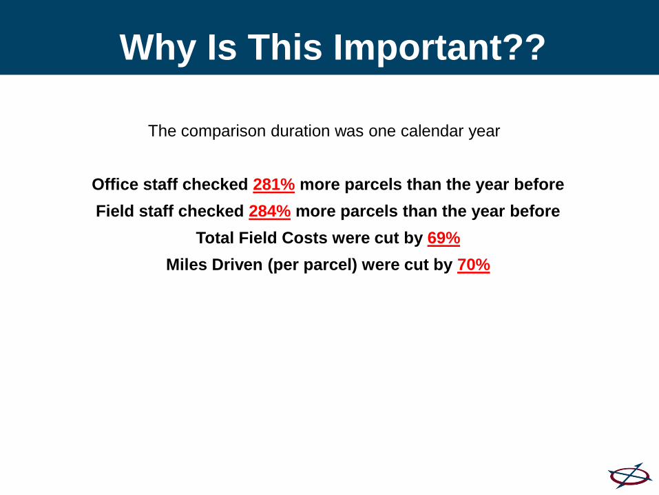
The comparison duration was one calendar year
Office staff checked 281% more parcels than the year before
Field staff checked 284% more parcels than the year before
Total Field Costs were cut by 69%
Miles Driven (per parcel) were cut by 70%
Why Is This Important??
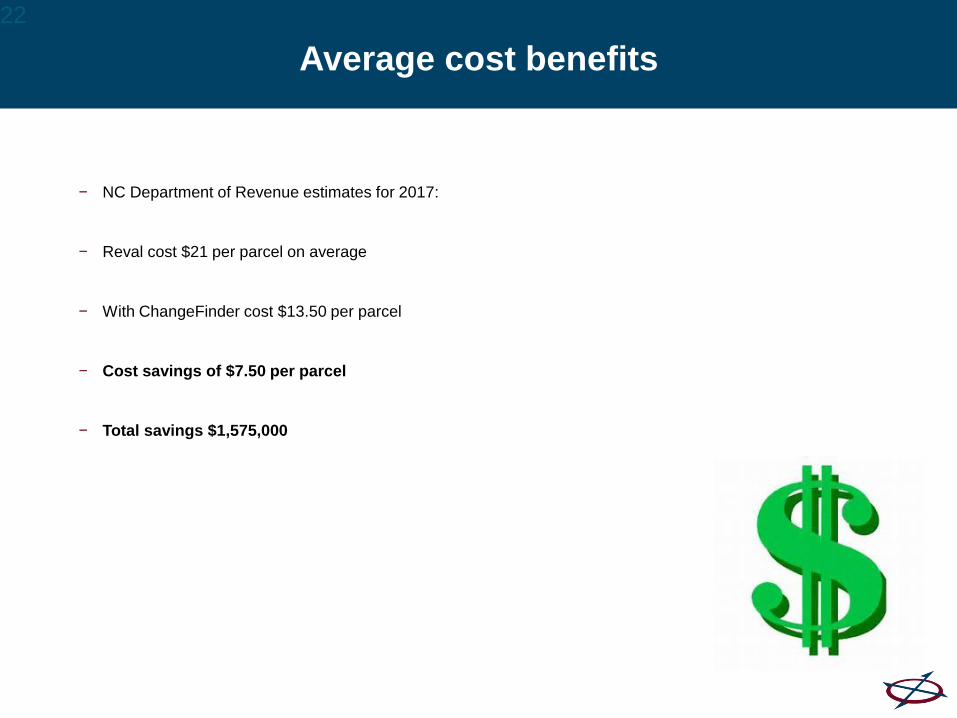
Average cost benefits
− NC Department of Revenue estimates for 2017:
− Reval cost $21 per parcel on average
− With ChangeFinder cost $13.50 per parcel
− Cost savings of $7.50 per parcel
− Total savings $1,575,000
22

Integrations
• Bring intelligent obliques into your CAMA
system and your GIS

CONNECTAssessment

DEVNET CAMA SYSTEM

Aumentum – Property Tax SystemCAMA, GIS, and Pictometry

Slide masters with tagline
Esri Web AppBuilder Integration
(Widget)
1
3
2

APPRAISAL WORKSTATION

Case Studies
• A few slides from a recent User Group Meeting

REAPPRAISAL TOOL MOST EFFICIENT, COST EFFECTIVE AND EASIEST TOOL AVAILABLE FOR REAPPRAISAL WORK
PROPERTY REVIEW FROM DESK
CONFIRM MEASUREMENTS FROM DESK
CONFIRM LAND ADJUSTMENTS FROM DESK
SPECIAL PROJECTS WITHIN REAPPRAISAL

REAPPRAISAL TOOL
PROVIDES SUPPORTING DOCUMENTATION
REFERENCE POINT IN TIME---REAPPRAISAL DATE
VISUAL GUIDE FOR MAKING DECISIONS AND OPINIONS

REAPPRAISAL TOOL INSTILLS CONFIDENCE FOR STAFF IN BOTH:
WORK PRODUCT
DEALING WITH PROPERTY OWNERS
APPEAL EFFICIENCY
ABILITY TO PROCESS QUICKER
TAXPAYERS CAN UNDERSTAND AN IMAGE
PROVIDES REALITY FOR BOARD OF E/R, AND NCPTC

Oblique Images ideal for large buildings or
parcels with difficult access
33

Split Screens
• Side by side images make it easy to identify change
• Noted changes are held in a work Queue
• Imagery is good enough to identify not only structural changes but upgrades to existing structures as
well
34

Pictometry ChangeFinder
35

Filters & Queues
36
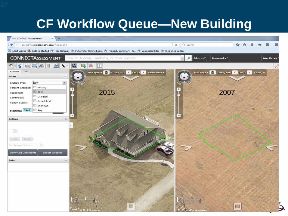
CF Workflow Queue—New Building
37
20072015
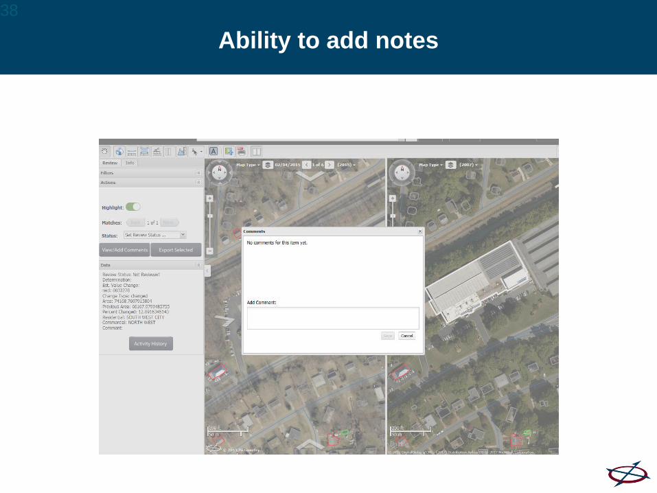
Ability to add notes
38
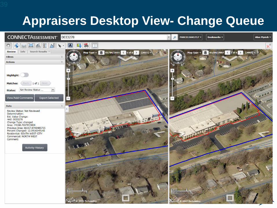
Appraisers Desktop View- Change Queue
39

More Changes40

Sketch Change Queue
41

Garage changed to living
quarters
42

Rural Areas- Many Buildings are built
without a Permit
43

Demolition Review Queue44
Demolished
for Hotel &
Apartment
Complex

CF Reports on Project Progress by Work
Areas
45
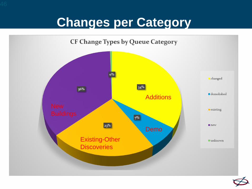
Changes per Category
46
New
Buildings
Additions
Demo
Existing-Other
Discoveries

One NC Example Of ROI
− County total savings: $1,575,000
− Total Revenue Discovered: $1,369,511
− Total Benefit: $2,944,511
− Revenue benefit continues to grow each year
47
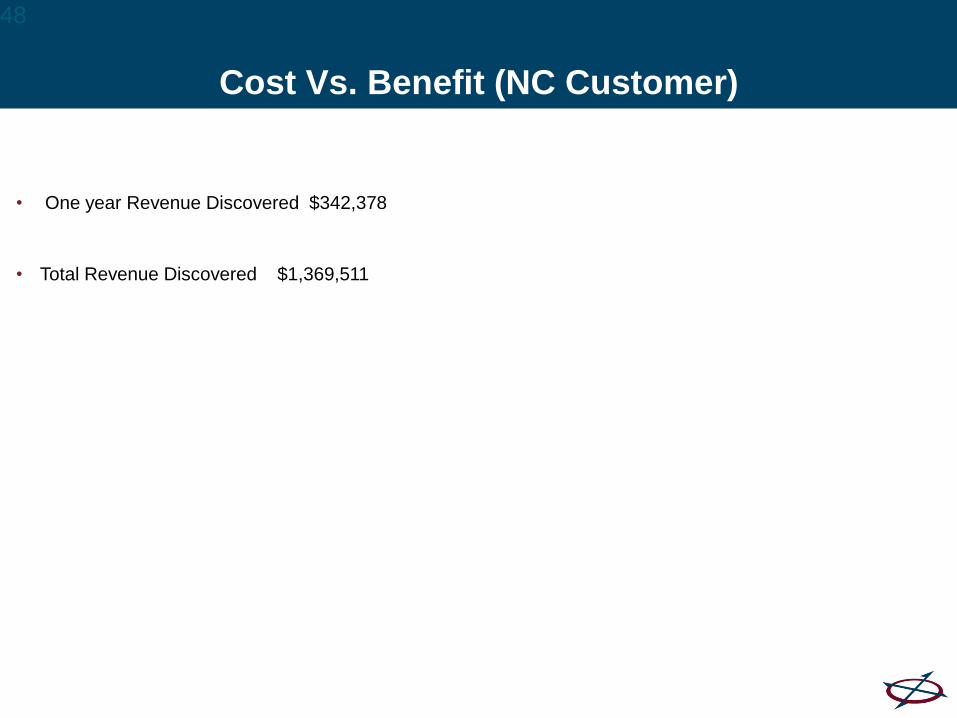
Cost Vs. Benefit (NC Customer)
• One year Revenue Discovered $342,378
• Total Revenue Discovered $1,369,511
48

ChangeFinder
• Allows appraisal staff to do an electronic inventory of buildings & outbuildings that have been built
since 2007.
• Appraisers reviewed parcels for buildings that had been added or removed since 2007.
• To date appraisal staff have added or removed;
Building Value Added: $50,372,669
Building Value Removed: $3,503,722
49

Bottom Line
• “This technology makes Reassessment more efficient and is cost-effective by both saving time and
by ensuring accurate data”

Hurricane Harvey
• 22 planes staged & flying around TX
• First to fly post-storm
− In the air scouting on Monday
− Permitted access into the airspace on Tuesday
− First imagery processed on Wednesday
• Over 6,000 sq. miles of imagery captured
• Estimated 340 hours of flight time
• Ferried planes to TX from all across the country
Hurricane Relief Efforts
• Donated 40,000 meals including clean water to the Southeast Texas Food Bank to the City of
Beaumont, TX (customers of ours) after they ran out of clean water completely.
• Worked with Texas Cares to donate bottled water to those affected.
• Complimentary online tool, accessible through desktop and mobile for evacuees to assess their
homes remotely.
• Created within 4 days of taking flight in TX
• Employees physically flew to TX to receive drives to hand-deliver to the office over Labor Day
weekend.
• http://harvey2017.eagleview.com/

Machine Learning
• EagleView is working with insurance carriers to review an image and classify damage
efficiently by stratifying potential property damage based on probability thresholds.
• This high-speed process allows billions of image pixels to be analyzed quickly – far faster
than can be analyzed with the human eye.