technology applications for project management - dallas county · technology applications for...
TRANSCRIPT

TECHNOLOGY APPLICATIONS FOR PROJECT MANAGEMENT
Speaker:
Marc Cottingame, PE
Dallas Water Utilities
“GIS APPLICATION AND TOOLS”
2011 S.A.M.E. INFRASTRUCTURE FORUM
DALLAS, TEXAS
DECEMBER 1, 2011

2
Biography
DWU - Cottingame
Marc Cottingame, PEBorn and raised in Richardson, TexasGraduated with Bachelor of Science in Engineering from Texas Tech University 1992Marc Cottingame worked from 1992 until 2003 as a consultant for different firms
performing Master Planning, I/I Studies, and water and wastewater pipeline design and construction services for municipalities nationwide including the City of Dallas and other cities within the DFW Metroplex. Marc Cottingame joined Dallas Water Utilities in April 2003 as a Project Manager in the Capital Improvement Pipeline Project Management Division. In 2008, Marc Cottingame promoted to the Program Manager of the Utility Automation and Integration Division of DWU.
As the Program Manager of the Utility Automation and Integration Division of Dallas Water Utilities, Marc Cottingame manages the Water Departments Technical Services Groups including GIS Services Team who develops and maintains the GIS database and is responsible for the growth of the asset management program.
12/1/2011
2

3
Outline
DWU - Cottingame
Dallas Water Utility Interesting Facts Horizontal Project Outlook DWU Engagement/Organization Project Coordination GIS Project Management/Coordination Tools GIS Asset Documentation
12/1/2011
3

4
4
Challenge: Putting
The benefits of GIS-based project coordination practices are well established.
However, putting theory into practice can be challenging!
412/1/2011 DWU - Cottingame

5
5
Dallas Water Utility
Founded in 1881 1.3M in Dallas
1.2M in 38 Customer cities 699 sq miles Service Area 6 Reservoirs 3 Water Purification Plants 900mgd/142 bgy (fy10) 2 Waste Treatment Plants 260 mgd/67 bgy fy10
8,935 miles of mains 394,171 Distributed Assets $13B in total Assets
(replacement value)
512/1/2011 DWU - Cottingame

6
6
Pipeline, Growth – Southwest Pipeline
32.5 Miles Treated Water 96” thru 120”
Location Dallas County 214 Parcels 10 Cities
Cedar Hill, Desoto, Duncanville, Lancaster, Hutchins, Balch Springs, Mesquite, Sunnyvale and Dallas
Complete 2017 Massive Coordination Effort
612/1/2011 DWU - Cottingame

7
7
Pipeline Renewal/Replacement Forecast
Average age is 38.3 years Mean is not the message 40% built 1950-1960’s ~50% of system is > 50
years old 14.6% built in1970’s 1.5% per year Renewal
and Replacement Program
712/1/2011 DWU - Cottingame

8
Forecasted, Segments Needs/Pending Design Construction Total Segments
Capital Improvement 1,186 665 755 2,606
DWU Horizontal Project Summary
DWU - Cottingame
FY11 Construction Contract Type
% Contracts Segments Design Sheets Miles of Main
Capital Improvement 63% 510 1598 105.9
Private Development 24% 194 486 32.2
Relocations 13% 101 323 21.4
Total 100% 805 2407 159.5
Coordination required for all project e.g. G,R&R projects cross or are adjacent to other agencies’ infrastructure or projects.
12/1/2011
8

9
DWU Engagement\Organization
Capital Programs Regulatory and Growth Needs O&M Renewals and
Replacements Relocations
Coordinate Work by Other Agencies
Development Services Development and
Redevelopment Utility Automation
Document DWU Assets via GIS Provide Analysis and Tools to
Help Make Decisions
12/1/2011
9
DWU - Cottingame
http://www.dallascityhall.com/dwu/water_utilities.html

10
Project Management and Coordination
Fundamental Elements Optimize participation
and performance Scope of Work Schedule Budget
Location
12/1/2011
10
DWU - Cottingame

11
Traditional Project Coordination Tools
Lists Reports Maps Mapsco with Sticker-
Dots
12/1/2011
11
DWU - Cottingame

12
12
Modern Project Coordination Tools
Single View Utility Infrastructure Projects
Centralized Databases Capital Relocations Development
1212/1/2011 DWU - Cottingame

13
GIS Coordination Tools – Risk-based Approach for Renewal/Replacement
Critical Infrastructure Consequence of Failure
Condition Assessment Likelihood of Failure
Understanding of Risk Optimize
Renewal/Replacement Program
12/1/2011
13
DWU - Cottingame
1 Very Good
2 Good
3 Fair
4 Poor
5 Very Poor
C = 1 Low Impact
B = 2 Medium Impact
24% (959 miles)
A = 3 High Impact 4% (161 miles)
Con
sequ
ence
of F
ailu
re
Condition Score (Probability of Failure) Risk Score = Condition x
Consequence
WASTEWATER COLLECTION SYSTEM PIPE RISK RATINGRESULTS MATRIX
72% (2,850 miles)

14
14
GIS Coordination Tool – Trinity River Levee
Levee Boundary Soil Boring Locations Infrastructure
Penetrations Adjacent Construction Assist City Efforts for
Levee Certification
1412/1/2011 DWU - Cottingame
15
15
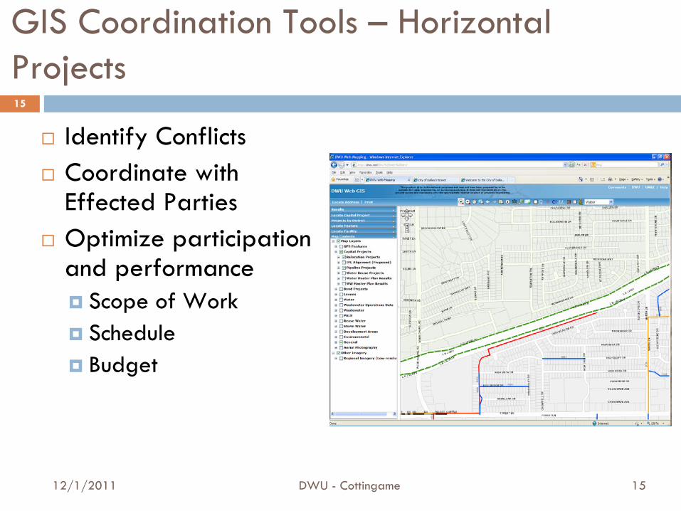
GIS Coordination Tools – Horizontal Projects
Identify Conflicts Coordinate with
Effected Parties Optimize participation
and performance Scope of Work Schedule Budget
1512/1/2011 DWU - Cottingame

16
16
Project Coordination Example Workflow –Project Research
Single View Web-based GIS
Key Project Data Research Reference Files
1612/1/2011 DWU - Cottingame

17
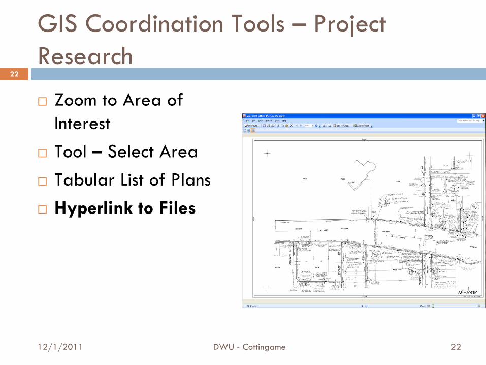
GIS Coordination Tools – Project Research
Zoom to Area of Interest
Tool – Select Area Tabular List of Plans Hyperlink to Files
12/1/2011
17
DWU - Cottingame

18
GIS Coordination Tools – Project Research
Zoom to Area of Interest
Tool – Select Area
Tabular List of Plans Hyperlink to Files
DWU - Cottingame12/1/2011
18

19
GIS Coordination Tools – Project Research
Zoom to Area of Interest
Tool – Select Area Tabular List of Plans
Hyperlink to Files
DWU - Cottingame12/1/2011
19

20
GIS Coordination Tools – Project Research
Zoom to Area of Interest
Tool – Select Area Tabular List of Plans Hyperlink to Files
DWU - Cottingame12/1/2011
20

21
GIS Coordination Tools – Project Research
Zoom to Area of Interest
Tool – Select Area Tabular List of Plans Hyperlink to Files
DWU - Cottingame12/1/2011
21
22
GIS Coordination Tools – Project Research
Zoom to Area of Interest
Tool – Select Area Tabular List of Plans Hyperlink to Files
DWU - Cottingame12/1/2011
22

23
Modern Project Coordination Tools
Geographic Information Systems Web GeoPDF Mobility
Automated Analysis\Reporting
12/1/2011
23
DWU - Cottingame
24
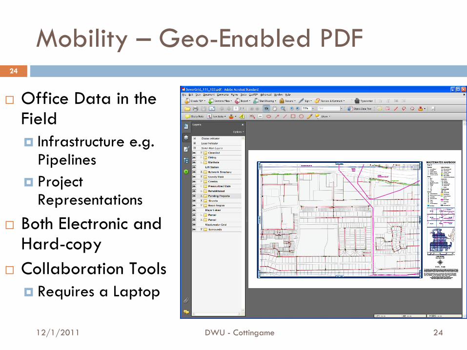
Mobility – Geo-Enabled PDF
Office Data in the Field Infrastructure e.g.
Pipelines Project
Representations Both Electronic and
Hard-copy Collaboration Tools
Requires a Laptop
12/1/2011
24
DWU - Cottingame

25
Mobility – GIS in the Field
Office Data in the Field Infrastructure e.g.
Pipelines Aerial/Parcels Project Representations
On-the-fly query data Red-up Corrections Disconnected – No
Wireless Required
DWU - Cottingame12/1/2011
25

26
Database Coordination Tools -Automated Analysis\Reporting
Centralized Databases Spatial Analysis Write Conflicts to
Table/Report Spatial Conflicts Status of Projects Owner/Contact
DWU - Cottingame12/1/2011
26

27
DWU –We’ve Come A Long Way!
DWU - Cottingame
1930’s 1960’s 1980’s 1990’s
•Wastewater•Original Dallas•Limited Info
•Bud Holcomb•Wastewater•Outgrew 1st Maps•More Info
•Block Maps•Water and Wastewater•Very Detailed•Massive Effort
•100% Water•55% Wastewater
•Digital•Water and Wastewater•Partially Integrated with WOMMS
Time2000’s
•Digital•Water and Wastewater•No Facilities•Maintained Separately from Digital Maps
100% GIS Automated – October 1, 2011
12/1/2011
27

28
Project Tracking – Update DWU’s Assets
Projects are tracked Triggers Indicate
Status Built Ready for GPS
As-built Sketches As-built GPS Up-to-date GIS
DWU - Cottingame12/1/2011
28

29
Modern Methods – Summary
Multiple Data Sources Effective Processes to
Keep Information Updated
Information Overload with Unnecessary data
Collaboration Confidentiality
Optimize Performance and Participation
Identify overlap and/or adjacency issues early
Make Better Decisions Readily answer Key
Questions Avoid delays and
minimize changes to Scope
12/1/2011
29
DWU - Cottingame
Challenges Benefits

30
Conclusion
DWU is Constantly Doing More with GIS
Continuous Process Improvements
GIS Field Technology Documenting Assets in
GIS GIS Project Research
and Coordination
12/1/2011
30
DWU - Cottingame
er!

31
31
Questions & Comments?
Contact Information:
Marc Cottingame, PE
Dallas Water Utilities
Phone: 214.671.9170
3112/1/2011 DWU - Cottingame
In life, questions are guaranteed; answers are not!