technical report on the resource …€¦ · figure 14.2 2017 geological model of umz and lmz as...
TRANSCRIPT
TECHNICAL REPORT ON THE RESOURCE ESTIMATE UPDATE FOR THE BRABANT-MCKENZIE PROPERTY,
BRABANT LAKE, SASKATCHEWAN, CANADA FOR
MURCHISON MINERALS LTD.
NOVEMBER 25, 2017
Prepared by: Finley Bakker, P.Geo.
TECHNICAL REPORT ON THE RESOURCE ESTIMATE UPDATE FOR THE BRABANT-MCKENZIE PROPERTY, BRABANT LAKE, SASKATCHEWAN, CANADA FOR MURCHISON MINERALS INC. Toronto, Ontario, Canada Effective Date: September 27, 2017
TECHNICAL REPORT ON THE RESOURCE ESTIMATE UPDATE FOR THE BRABANT-MCKENZIE PROPERTY, BRABANT LAKE, SASKATCHEWAN, CANADA FOR MURCHISON MINERALS LTD., Toronto, Ontario, Canada; Effective Date: September 27, 2017
i
CONTENTS
1. Summary .................................................................................................................................. 7
2. Introduction ........................................................................................................................... 13
3. Reliance on Other Experts ..................................................................................................... 14
4. Property Location and Description ........................................................................................ 15
4.1 Location .......................................................................................................................... 15
4.2 Property .......................................................................................................................... 17
4.3 History of Claims ............................................................................................................. 21
4.3.1 Previous Work by Other Parties .............................................................................. 21
4.3.2 Previous Work by Murchison Minerals ................................................................... 24
4.4 Environment and Socio-Economic Issues ....................................................................... 26
4.4.1 Environmental Liabilities ......................................................................................... 26
4.4.2 Treaty ...................................................................................................................... 26
4.5 Surface Rights ................................................................................................................. 27
4.6 Work Permits .................................................................................................................. 27
5. Accessibility, Climate, Local Resources, Infrastructure, and Physiography ........................... 27
5.1 Accessibility .................................................................................................................... 27
5.2 Climate ............................................................................................................................ 28
5.3 Local Resources and Infrastructure ................................................................................ 28
5.4 Physiography, Flora and Fauna ...................................................................................... 28
6. History .................................................................................................................................... 29
7. Geological Setting and Mineralization ................................................................................... 40
7.1 Regional Geology ............................................................................................................ 40
7.2 Property Geology ............................................................................................................ 44
7.3 Lithologies ....................................................................................................................... 45
7.3.1 Biotite and Garnet-Biotite Gneiss ........................................................................... 45
7.3.2 Amphibolites ........................................................................................................... 45
7.3.3 Calc-silicate Gneisses ............................................................................................... 46
7.3.4 Felsic Gneisses ......................................................................................................... 46
7.3.5 Pegmatites ............................................................................................................... 46
8. Deposit Types ......................................................................................................................... 47
8.1 Deposit Classification ...................................................................................................... 49
8.2 Mineralization ................................................................................................................. 50
8.2.1 Upper Mineralized Zone (UMZ) .............................................................................. 52
8.2.2 Lower Mineralized Zone (LMZ) ............................................................................... 52
8.3 Structure ......................................................................................................................... 53
TECHNICAL REPORT ON THE RESOURCE ESTIMATE UPDATE FOR THE BRABANT-MCKENZIE PROPERTY, BRABANT LAKE, SASKATCHEWAN, CANADA FOR MURCHISON MINERALS LTD., Toronto, Ontario, Canada; Effective Date: September 27, 2017
ii
8.4 Alteration ........................................................................................................................ 53
9. Exploration ............................................................................................................................. 53
10. Drilling .................................................................................................................................... 55
11. Sample Preparation, Analyses and Security .......................................................................... 56
12. Data Verification .................................................................................................................... 58
12.2 Discussion of Results ...................................................................................................... 65
13. Mineral Processing and Metallurgical Testing ....................................................................... 65
14. Mineral Resource Estimates .................................................................................................. 65
14.1 Introduction .................................................................................................................... 65
14.2 Database ......................................................................................................................... 66
14.3 Data Verification ............................................................................................................. 66
14.4 Domain Interpolation ..................................................................................................... 66
14.5 Lens/Rock Code .............................................................................................................. 68
14.6 Composites ..................................................................................................................... 69
14.7 Grade Capping ................................................................................................................ 69
14.8 Variography...................................................................................................................... 69
14.8.1 Discussion of Variograms ........................................................................................ 72
14.9 Bulk Density ..................................................................................................................... 72
14.10 Block Model ................................................................................................................... 72
14.11 Resource Classification .............................................................................................. 73
14.12 Resource Estimate .......................................................................................................... 76
14.13 Calculation of Cut-off ...................................................................................................... 76
14.14 Confirmation of Estimate ............................................................................................... 82
14.15 Discussion of Results ...................................................................................................... 82
15. Mineral Reserve Estimates .................................................................................................... 86
16. Mining Methods ..................................................................................................................... 86
17. Recovery Methods ................................................................................................................. 86
18. Property Infrastructure .......................................................................................................... 87
19. Market Studies and Contracts ............................................................................................... 87
20. Environmental Studies, Permitting and Social or Community Impact .................................. 87
21. Capital and Operating Costs .................................................................................................. 87
22. Economic Analysis .................................................................................................................. 87
23. Adjacent Properties ............................................................................................................... 87
24. Other Relevant Data and Information ................................................................................... 87
25. Interpretation and Conclusions ............................................................................................. 88
TECHNICAL REPORT ON THE RESOURCE ESTIMATE UPDATE FOR THE BRABANT-MCKENZIE PROPERTY, BRABANT LAKE, SASKATCHEWAN, CANADA FOR MURCHISON MINERALS LTD., Toronto, Ontario, Canada; Effective Date: September 27, 2017
iii
26. Recommendations ................................................................................................................. 89
27. References ............................................................................................................................. 97
Statement of Qualifications ........................................................................................................ 101
Appendices .................................................................................................................................. 104
Appendix I Plan View of Deposit by Elevation and % Zinc Equivalent Grade Shell ............... 104
TECHNICAL REPORT ON THE RESOURCE ESTIMATE UPDATE FOR THE BRABANT-MCKENZIE PROPERTY, BRABANT LAKE, SASKATCHEWAN, CANADA FOR MURCHISON MINERALS LTD., Toronto, Ontario, Canada; Effective Date: September 27, 2017
iv
TABLES TABLE 1.1 INDICATED AND INFERRED RESOURCE ........................................................................... 8
TABLE 2.1 LIST OF ABBREVIATIONS ................................................................................................ 14
TABLE 4.1 EFFECTIVE DATES AND REQUIRED ASSESSMENT AND ASSESSMENT CREDITS FOR M.L.
5054 AND THE MINERAL CLAIMS AS OF THE EFFECTIVE DATE OF THIS REPORT ...................... 19
TABLE 4.2 INCENTIVE LIENS ON M.L. 5054 .................................................................................... 19
TABLE 6.1 1988-1989 GAMSAN DRILLING DATA............................................................................ 32
TABLE 6.2 1988-1989 GAMSAN SIGNIFICANT INTERSECTIONS ..................................................... 32
TABLE 6.3 1988-1989 GAMSAN SIGNIFICANT INTERSECTIONS CONTD. ........................................ 33
TABLE 6.4 1993 PDC DRILLING DATA ............................................................................................. 34
TABLE 6.5 1933 PDC DRILLING SIGNIFICANT INTERSECTIONS ....................................................... 35
TABLE 6.6 BOREHOLE PULSE-EM TARGETS .................................................................................... 35
TABLE 6.7 2008 MINERAL RESOURCE ESTIMATE ........................................................................... 37
TABLE 10.1 SUMMARY OF DRILLING ON BRABANT-MCKENZIE PROPERTY PRIOR TO DRILLING BY
MURCHISON MINERALS LTD. ....................................................................................................... 55
TABLE 10.2 SUMMARY OF 2017 DRILL DATA ON BRABANT-MCKENZIE PROPERTY ........................ 55
TABLE 10.3 LIST OF SIGNIFICANT INTERSECTIONS IN 2017 BRABANT-MCKENZIE DRILLING .......... 56
TABLE 14.1 EFFECT OF TRIMMING/DOWNGRADING OUTLINING INDICATED TONNES .................. 75
TABLE 14.2 RANGE OF INDICATED RESOURCE BASED ON < 30 METER FROM DIAMOND DRILL
HOLE SHOWING VARIOUS CUT-OFFS........................................................................................... 76
TABLE 14.3 RANGE OF INDICATED RESOURCE BASED ON > 30 AND < 60 METER FROM DIAMOND
DRILL HOLE SHOWING VARIOUS CUT-OFFS ................................................................................. 76
TABLE 14.4 METAL PRICES AND EXCHANGE RATE ........................................................................... 76
TABLE 14.5 CALCULATION OF NSR /ZINC EQUIVALENT CUT OFF .................................................... 77
TABLE 14.6 INDICATED AND INFERRED RESOURCE ......................................................................... 81
TABLE 14.7 SHOWING REPRESENTATIVE VALUE OF INDICATED RESOURCE ................................... 82
TABLE 14.8 LIST OF SIGNIFICANT INTERSECTIONS IN 2017 DIAMOND DRILLING ........................... 84
TABLE 14.9 LIST OF DIAMOND DRILL COLLARS FROM 2017 DIAMOND DRILLING ........................ 84
TABLE 26.1 LOCATION OF BRABANT-MCKENZIE DEPOSIT PROPOSED DIAMOND DRILL HOLES (NQ
CORE) PROPOSED BUDGET ...................................................................................................... 95
TABLE 26.2 PROPOSED BUDGET ...................................................................................................... 96
TECHNICAL REPORT ON THE RESOURCE ESTIMATE UPDATE FOR THE BRABANT-MCKENZIE PROPERTY, BRABANT LAKE, SASKATCHEWAN, CANADA FOR MURCHISON MINERALS LTD., Toronto, Ontario, Canada; Effective Date: September 27, 2017
v
FIGURES FIGURE 4. 1 LOCATION MAP ......................................................................................................... 15
FIGURE 4. 2 PROPERTY LOCATION ................................................................................................ 16
FIGURE 4. 3 LOCATION OF DEPOSIT RELATIVE TO LAND MARKS .................................................. 17
FIGURE 4. 4 BRABANT-MCKENZIE PROPERTY CLAIMS .................................................................. 20
FIGURE 5.1 VIEW OF PROPERTY IN VICINITY OF DRILL AREA ....................................................... 29
FIGURE 7.1 SUBDIVISIONS OF THE TRANS HUDSONIAN OROGENY ............................................. 42
FIGURE 7.2 GEOLOGY OF THE REINDEER ZONE IN NORTHERN SASKATCHEWAN ....................... 44
FIGURE 7.3 BRABANT-MCKENZIE PROPERTY GEOLOGY ............................................................... 45
FIGURE 8.1 DEPOSIT STYLES ......................................................................................................... 48
FIGURE 8.2 SHOWING MINERAL TEXTURE ................................................................................... 50
FIGURE 8.3 SHOWING STACKED NATURE OF LENSES .................................................................. 51
FIGURE 12.1 LAB COMPARISONS OF SILVER ASSAYS ..................................................................... 58
FIGURE 12.2 LAB COMPARISONS OF LEAD ASSAYS ........................................................................ 59
FIGURE 12.3 LAB COMPARISONS OF ZINC ASSAYS......................................................................... 59
FIGURE 12.4 LAB COMPARISONS OF COPPER ASSAYS ................................................................... 60
FIGURE 12.5 LOW GRADE REFERENCE MATERIAL USED ................................................................ 60
FIGURE 12.6 HIGH GRADE REFERENCE MATERIAL USED ............................................................... 61
FIGURE 12.7 QAQC HIGH GRADE COPPER ...................................................................................... 61
FIGURE 12.8 QAQC LOW GRADE COPPER ...................................................................................... 62
FIGURE 12.9 QAQC HIGH GRADE ZINC ........................................................................................... 62
FIGURE 12.10 QAQC LOW GRADE ZINC ............................................................................................ 63
FIGURE 12.11 QAQC HIGH GRADE LEAD .......................................................................................... 63
FIGURE 12.12 QAQC LOW GRADE LEAD ........................................................................................... 64
FIGURE 12.13 QAQC HIGH GRADE SILVER ........................................................................................ 64
FIGURE 12.14 QAQC LOW GRADE SILVER ........................................................................................ 65
FIGURE 14.1 2008 RESOURCE DOMAINS AS PREVIOUSLY MODELED IN GEMS ............................. 67
FIGURE 14.2 2017 GEOLOGICAL MODEL OF UMZ AND LMZ AS MODELED IN MINESIGHT ........... 68
FIGURE 14.3 3D VARIOGRAM OF METALS ..................................................................................... 70
FIGURE 14.4 3D VARIOGRAM OF METALS ..................................................................................... 71
FIGURE 14.5 3D VARIOGRAM OF METALS ..................................................................................... 71
FIGURE 14.6 3D VARIOGRAM OF METALS ..................................................................................... 71
FIGURE 14.7 DIMENSIONS OF 3D BLOCK MODEL .......................................................................... 73
FIGURE 14.8 FLOW CHART OF RESOURCE CLASSIFICATION ........................................................... 73
FIGURE 14.9 GRADE SHELL OF MATERIAL REPORTED AS INDICATED (RED) BASED ON < 30 M
TO DIAMOND DRILL HOLE AND 2 HOLE MINIMUM .................................................................... 74
FIGURE 14.10 GRADE SHELLS SHOWING LOCATION OF RESOURCE AREAS OF INFLUENCE ............ 75
FIGURE 14.11 ZINC EQUIVALENT TONNAGE CURVE LIMITED TO UMZ AND LMZ ........................... 77
FIGURE 14.12 HISTOGRAM OF ZINC EQUIVALENT CUT-OFF LIMITED TO LMZ AND UMZ ............... 78
FIGURE 14.13 SHOWING CONTINUITY OF 5% ZINC EQUIVALENT GRADE SHELL (PURPLE)–
INDICATED (RED) SUPERIMPOSED IN RED ................................................................................. 79
TECHNICAL REPORT ON THE RESOURCE ESTIMATE UPDATE FOR THE BRABANT-MCKENZIE PROPERTY, BRABANT LAKE, SASKATCHEWAN, CANADA FOR MURCHISON MINERALS LTD., Toronto, Ontario, Canada; Effective Date: September 27, 2017
vi
FIGURE 14.14 INDICATED (RED) AND INFERRED (BLUE) DOMAINS SUPERIMPOSED ON 5% ZINC
EQUIVALENT GRADE SHELL (PURPLE) ......................................................................................... 80
FIGURE 14.15 PLOT OF 2017 DRILLING SHOWS THAT THEY WOULD HAVE HAD MINIMAL IMPACT
ON INDICATED RESOURCE (RED)S .............................................................................................. 83
FIGURE 14.16 2017 DIAMOND DRILL HOLE LOCATIONS .................................................................. 83
FIGURE 14.17 GRADE SHELLS OF LMZ – HANGING WALL VIEW ...................................................... 85
FIGURE 14.18 GRADE SHELLS OF UMZ - HANGING WALL VIEW ...................................................... 86
FIGURE 25.1 FELSIC VOLCANIC DEPOSIT AFTER GALLEY ET AL 2007 ............................................. 88
FIGURE 26.1 PLAN OVERVIEW OF PROPOSED DIAMOND DRILL SITES............................................ 90
FIGURE 26.2 SECTION LOOKING WEST OF ANOMALY C AND ANOMALY D ..................................... 91
FIGURE 26.3 PLAN VIEW OF ANOMALY C AND ANOMALY D PROPOSED ........................................ 92
FIGURE 26.4 PLAN VIEW OF PROPOSED BRABANT MCKENZIE DIAMOND DRILL SITES ................... 93
FIGURE 26.5 SECTION LOOKING WEST OF BRABANT MCKENZIE PROPOSED DIAMOND DRILL SITES
..................................................................................................................................................... 94
TECHNICAL REPORT ON THE RESOURCE ESTIMATE UPDATE FOR THE BRABANT-MCKENZIE PROPERTY, BRABANT LAKE, SASKATCHEWAN, CANADA FOR MURCHISON MINERALS LTD., Toronto, Ontario, Canada; Effective Date: September 27, 2017
vii
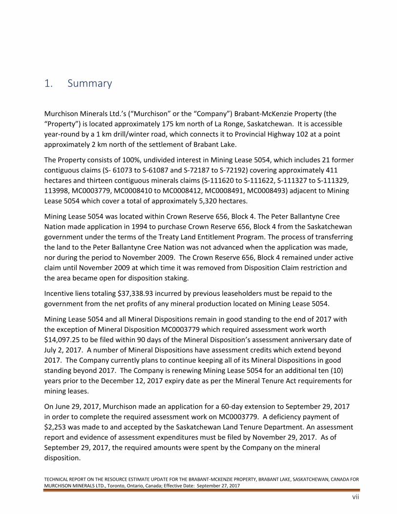
1. Summary
Murchison Minerals Ltd.’s (“Murchison” or the “Company”) Brabant-McKenzie Property (the
“Property”) is located approximately 175 km north of La Ronge, Saskatchewan. It is accessible
year-round by a 1 km drill/winter road, which connects it to Provincial Highway 102 at a point
approximately 2 km north of the settlement of Brabant Lake.
The Property consists of 100%, undivided interest in Mining Lease 5054, which includes 21 former
contiguous claims (S- 61073 to S-61087 and S-72187 to S-72192) covering approximately 411
hectares and thirteen contiguous minerals claims (S-111620 to S-111622, S-111327 to S-111329,
113998, MC0003779, MC0008410 to MC0008412, MC0008491, MC0008493) adjacent to Mining
Lease 5054 which cover a total of approximately 5,320 hectares.
Mining Lease 5054 was located within Crown Reserve 656, Block 4. The Peter Ballantyne Cree
Nation made application in 1994 to purchase Crown Reserve 656, Block 4 from the Saskatchewan
government under the terms of the Treaty Land Entitlement Program. The process of transferring
the land to the Peter Ballantyne Cree Nation was not advanced when the application was made,
nor during the period to November 2009. The Crown Reserve 656, Block 4 remained under active
claim until November 2009 at which time it was removed from Disposition Claim restriction and
the area became open for disposition staking.
Incentive liens totaling $37,338.93 incurred by previous leaseholders must be repaid to the
government from the net profits of any mineral production located on Mining Lease 5054.
Mining Lease 5054 and all Mineral Dispositions remain in good standing to the end of 2017 with
the exception of Mineral Disposition MC0003779 which required assessment work worth
$14,097.25 to be filed within 90 days of the Mineral Disposition’s assessment anniversary date of
July 2, 2017. A number of Mineral Dispositions have assessment credits which extend beyond
2017. The Company currently plans to continue keeping all of its Mineral Dispositions in good
standing beyond 2017. The Company is renewing Mining Lease 5054 for an additional ten (10)
years prior to the December 12, 2017 expiry date as per the Mineral Tenure Act requirements for
mining leases.
On June 29, 2017, Murchison made an application for a 60-day extension to September 29, 2017
in order to complete the required assessment work on MC0003779. A deficiency payment of
$2,253 was made to and accepted by the Saskatchewan Land Tenure Department. An assessment
report and evidence of assessment expenditures must be filed by November 29, 2017. As of
September 29, 2017, the required amounts were spent by the Company on the mineral
disposition.
TECHNICAL REPORT ON THE RESOURCE ESTIMATE UPDATE FOR THE BRABANT-MCKENZIE PROPERTY, BRABANT LAKE, SASKATCHEWAN, CANADA FOR MURCHISON MINERALS LTD., Toronto, Ontario, Canada; Effective Date: September 27, 2017
8
The Property is located within the Reindeer Zone of the Early Proterozoic TransHudson Orogen.
The Reindeer Zone is comprised of a lithologically and structurally complex collage of arc-related
volcanic and plutonic rocks, coeval or derived volcanogenic clastics, subordinate later arkosic
mollase assemblages and crustal melt fractions. The Reindeer Zone has been subdivided into a
series of domains. The McLennan Lake Tectonic Zone separates the lower metamorphic grade
volcanic and intrusive rocks of the La Ronge domain from the amphibolite to granulite facies
gneisses of the MacLean Lake Belt to the east.
The Property is situated less than 5 km east of the McLennan Lake Tectonic Zone in the western
part of the MacLean Lake Belt and straddles the boundary between the MacLean Lake Gneisses
and the McLennan Group meta-arkoses. The McLean Lake Gneisses are interpreted as
representing mainly proximal volcanogenic greywackes with subordinate amounts of volcanic and
volcanoclastics rocks and conglomeratic fan deposits. The McLennan Group is interpreted as a
molasse assemblage with repetitious upward fining cycles of immature, fluvial, lithic and
feldspathic sandstones and conglomerates. Metamorphic grades in the MacLean Lake Belt locally
attain granulite facies.
The Property is covered by a thick blanket of Pleistocene to Recent lacustrine sediments. Outcrop
is limited but is present in a series of ridges trending northeast–southwest along the length of the
Property. Biotite gneiss and semi-continuous bands of intercalated amphibolite (+/- biotite) and
calc-silicate gneisses are assigned to the McLennan Group and comprise the predominant
lithologies on the Property. Garnetiferous biotite gneiss/migmatite which underlies the
easternmost part of the Property is included in the MacLean Lake Gneisses. Pegmatites and other
evidence of melt fractions are common, locally exceeding 50% by volume of the MacLean Lake
Belt.
Prospecting in 1956 led to the discovery of what had become known as the McKenzie (a.k.a. Peg )
deposit, now the Brabant-McKenzie Deposit (or “the Deposit”). Since the Deposit’s discovery, the
Property has been subjected to a variety of airborne and ground geophysical surveys, limited soil
sampling, trenching, geological mapping and diamond drilling.
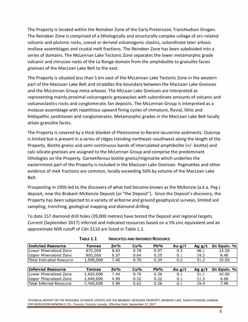
To date 157 diamond drill holes (39,000 metres) have tested the Deposit and regional targets.
Current (September 2017) inferred and indicated resources based on a 5% zinc equivalent and an
approximate NSR cutoff of Cdn $110 are listed in Table 1.1.
TABLE 1.1 INDICATED AND INFERRED RESOURCE
TECHNICAL REPORT ON THE RESOURCE ESTIMATE UPDATE FOR THE BRABANT-MCKENZIE PROPERTY, BRABANT LAKE, SASKATCHEWAN, CANADA FOR MURCHISON MINERALS LTD., Toronto, Ontario, Canada; Effective Date: September 27, 2017
9
Tonnes may not add due to rounding
The resource for the Brabant-McKenzie zinc deposit was estimated based on metal prices of US $1.20/lb zinc, $2.50/lb copper, $1.00/lb lead, $16.00/oz silver and $1200/oz/gold, and a US$ exchange rate of $1.10. An NSR cut-off of $110/tonne and a 5% zinc equivalent based on above metal prices and an average recovery of 75% for all metals for underground mining and milling was utilized to report the resource.
The Deposit consists of two parallel, generally north-north-easterly striking and moderately west-
northwesterly dipping zones referred to as the Upper and Lower Zones.
The Brabant-McKenzie Deposit consists of variable amounts of pyrrhotite, sphalerite, pyrite,
chalcopyrite and galena as tabular to lensoid bodies of disseminated to massive sulphide,
sulphide-rich breccias, concordant to discordant veins and veinlets. Historically, the Deposit’s
textures within the sulphide-rich breccias suggested that the deposit had been injected or, more
likely, remobilized. The Deposit shares many textural and metamorphic characteristics with other
massive sulphide deposits found in higher metamorphic grade terranes such as those of the
Manitouwadge camp in Ontario and of the Sherridon area of Manitoba.
Limited petrography, micro-probe analyses and preliminary metallurgical testing indicate that the
sphalerite is marmatitic, that efficient copper-zinc recoveries are possible and marketable grade
zinc and copper concentrates can be produced. These preliminary flotation tests were not
optimized, and more bench scale testing is warranted.
Many of the historical diamond drill holes on the Deposit did not go deep enough to intersect the
Lower Zone. Based on the latest drill results, the Deposit remains open down plunge and laterally.
The author of this report consider that the potential to significantly increase the size of the
Brabant-McKenzie deposit is probable, particularly in the Lower Zone where some of the higher-
grade intersections have been achieved
An initial Phase I exploration program conducted in late 2006 included line cutting, ground
geophysical surveys, MAG and HLEM, and 20 diamond drill holes totaling 7,102.24 m. The Phase I
exploration program was designed to confirm higher grade intersections from previous drilling
and to expand upon the known resources.
From early June 2007 to mid-February 2008, Manicouagan Minerals Inc. completed a drilling
Phase II program consisting of 29 holes totaling 8,257.78 m. These holes were drilled in a series
of fences designed to build upon the known resource and identify higher grade and thicker
mineralized trends, particularly within the Lower Zone.
All holes completed to their designed depths intersected at least one mineralized horizon. Up to
four mineralized zones were intersected in individual holes. The correlation of multiple zones
between holes was not well understood locally at the time because, except for the Footwall Zone,
the geological characteristics of the Hangingwall, Upper and Lower Zones are grossly similar.
Generally, the Lower Zone is higher in both Zn and Cu grades with respect to the Hangingwall and
Upper Zones, but not universally.
TECHNICAL REPORT ON THE RESOURCE ESTIMATE UPDATE FOR THE BRABANT-MCKENZIE PROPERTY, BRABANT LAKE, SASKATCHEWAN, CANADA FOR MURCHISON MINERALS LTD., Toronto, Ontario, Canada; Effective Date: September 27, 2017
10
Based on the results of the previous diamond drill programs a Phase III exploration program was
proposed to further define the extent of the deposit.
The Phase III program proposal which consisted of additional diamond drilling, borehole EM
surveying, computerization of all drill hole and assay data as well as bench scale metallurgical
testing totaling $2,000,000 was contemplated to advance the Property. Given the downturn in
the capital markets in mid-2008, Manicouagan was unable to raise funding for this program and it
was therefore not carried out.
In 2010, Manicouagan expanded the Property to approximately 2,850 ha covering 15 kilometres
of the favourable geological horizon which hosts the Deposit. In March 2011, Manicouagan
completed a detailed 560-line kilometre airborne VTEM PLUS geophysical survey which covered
the entire 2,850 ha land package including the Deposit. A number of VTEM conductor anomalies
identified in the survey were modeled by GeophysicsOne Inc. as potential diamond drill targets.
In November 2011, Manicouagan optioned the Property to Votorantim Metals Canada
(“Votorantim”).
In 2012, Votorantim completed a 12-hole diamond drill program totalling 2,429.5 metres
designed to test 10 VTEM conductor anomalies. After reviewing the results of its exploration
program, Votorantim advised the Company that it had elected not to continue its option and
returned the Property to Manicouagan in May 2012.
In 2014, Manicouagan completed an amalgamation via a reverse take over with Flemish Gold
Corp. (“Flemish Gold”) in which Manicouagan acquired all the issued common shares of Flemish
Gold in exchange for common shares of Manicouagan. The resulting company was renamed
Murchison Minerals Ltd. (“Murchison” or the “Company”).
In June 2015, Murchison staked an additional 940 hectares, adjacent to its 2,850 hectares on the
Property. The area was considered to be prospective for zinc-copper because it covers EM
conductor trends identified from the 2011 VTEM survey, but located outside the original
boundary of the Property.
In December 2015, Murchison Minerals Ltd. conducted a limited ground fixed loop Time Domain
Electromagnetic (“TDEM”) magnetic ground survey and one line of SQUID EM. The geophysics
program was designed to test the Deposit’s southern extension.
In 2016, Murchison conducted a borehole EM geophysics survey on five previously drilled holes
designed to continue testing the lateral and downdip extents of the Deposit. The survey was
successful in identifying numerous conductive electromagnetic plates that are coincident with
thicker zones of the Deposit and areas with little or no testing by previous drilling immediately
adjacent to the Mineralized Zones.
The Company also conducted a Helicopter Airborne Sub Audio Magnetics geophysics survey
(“HeliSAM”) which covered the main Deposit, the Mining Lease and claims immediately adjacent
the Mining Lease. Interpretation of the data suggests that the Deposit has a down dip extent of
TECHNICAL REPORT ON THE RESOURCE ESTIMATE UPDATE FOR THE BRABANT-MCKENZIE PROPERTY, BRABANT LAKE, SASKATCHEWAN, CANADA FOR MURCHISON MINERALS LTD., Toronto, Ontario, Canada; Effective Date: September 27, 2017
11
approximately 1,000 metres while historic drilling of the Deposit had identified VMS style
mineralization to a current down dip depth extent of 520 metres.
Results also indicated that two new large discrete conductors were also identified approximately
1.5 kilometres southwest (Anomaly C) and 1.4 kilometres due south (Anomaly D) of the Deposit.
Neither target has been drill tested.
The Company completed a follow up ground SQUID EM geophysics program in February 2017
over the Anomaly C and Anomaly D HeliSAM conductor anomalies.
Results from the EM and Mag data indicate that Anomaly C represents a discrete conductive body
and a confirmed drill target with modeled EM plate dimensions measuring 1.4 km by 1.3 km. The
conductive body occurs at approximately 260 m depth from surface within the same geological
horizon as the Deposit.
Anomaly D is identified as a significantly large, very intense conductive body and is located on the
southeastern edge of the EM survey grid. Modeled plate dimensions measure a 1 km strike length
by 2- 3 km depth extents with the top edge of the plate at about 145 m from surface. The
conductivity of this body is measured at approximately 1,300 Siemens. By comparison, the
Deposit, which outcrops at surface, has a conductive range of 800 to 1,000 Siemens and current
dimensions of 1 km of strike length and 610 m of depth extent.
A geological prospecting program in the area of the projected Anomaly D modeled EM plate
surface expression was successful in identifying outcrop exposures of approximately 150 m in
strike length and containing sulphide mineralization of chalcopyrite and pyrrhotite. The evidence
of surface mineralization and its proximity to the conductive body combined with the size and
conductivity of the EM body presents the potential for a sulphide body of size.
In February and March 2017, Murchison Minerals completed a 5,600 m, 10-hole drill program
designed to test both the lateral and depth extents of the Deposit outside of the 2008, NI 43-101
resource estimate and away from the main central corridor of historic drilling.
Volcanogenic Massive Sulphide (VMS) style zinc-copper mineralization, was intersected by all ten
holes of the recently completed drill program. The results from the program were successful in
adding tonnage to the Deposit’s resource estimate while extending its down dip depth extent to
approximately 610 metres from surface. Additionally, drilling confirmed VMS mineralization at a
down dip extent of approximately 950 metres from surface.
Results from this drilling program and the historic drilling results were used to estimate a new
resource for the Deposit.
Based on the positive results of the 2017 winter drill program and the resource estimate update additional work is recommended to continue defining the Deposit extents and for potential tonnage additions to the resource. Additionally, drilling is proposed to test the new geophysical targets identified 1.5 km south of the Deposit. Based on drill results, borehole EM geophysics will be carried out on select drill holes on both the deposit and the geophysics targets.
TECHNICAL REPORT ON THE RESOURCE ESTIMATE UPDATE FOR THE BRABANT-MCKENZIE PROPERTY, BRABANT LAKE, SASKATCHEWAN, CANADA FOR MURCHISON MINERALS LTD., Toronto, Ontario, Canada; Effective Date: September 27, 2017
12
It is recommended that the current QA/QC and Specific Gravity programs be continued. Pulps and rejects should continue to be stored in anticipation of preliminary metallurgical testing. A projected budget of approximately $ 2,300,000 is proposed to fund the next stage of this exploration program in order to advance the Property.
TECHNICAL REPORT ON THE RESOURCE ESTIMATE UPDATE FOR THE BRABANT-MCKENZIE PROPERTY, BRABANT LAKE, SASKATCHEWAN, CANADA FOR MURCHISON MINERALS LTD., Toronto, Ontario, Canada; Effective Date: September 27, 2017
13
2. Introduction In February 2017, Finley Bakker Consulting (or “FBC”) was retained by Murchison Minerals Ltd.
(“Murchison” or the “Company”) to prepare an independent Technical Report (the “Report”) on
the Brabant-McKenzie Property, located approximately 175 km by road northeast of the town of
La Ronge, Saskatchewan. The report was commissioned by Murchison to comply with regulatory
disclosure and reporting requirements and may be used in support of future financing efforts.
This Technical Report conforms to National Instrument 43-101 Standards of Disclosure for
Mineral Properties.
Murchison is a Canadian mineral exploration company with projects in Quebec and Saskatchewan
and is a reporting issuer in British Columbia, Alberta, Saskatchewan, Manitoba, Ontario, Quebec,
New Brunswick, Nova Scotia, and Newfoundland and Labrador. The common shares of
Murchison trade on the Canadian Securities Exchange and the Corporation is under the
jurisdiction of the Ontario Securities Commission.
This Technical Report is in compliance with Form 43-101 F1 and Companion Policy 43-101 CP of
National Instrument 43-101 (Standards and Disclosure for Mineral Projects). Terms of
engagement for FBC are contained in a letter dated February 2017.
For this Technical Report, Finley Bakker, served as the Qualified Person responsible for the
preparation of the report.
A site visit to the Brabant-McKenzie Property was carried out by Finley Bakker, in the period
February 4 to March 23, 2017. The purpose of the visit was to monitor the diamond drill
program, confirm the massive sulphide nature of the sulphide mineralization, observe and assist
in core logging and sampling protocols, visit the active drill sites and landmarks, and identify any
other factors that may affect the program.
In preparing this report, the author reviewed and relied on geological reports, maps, and
miscellaneous technical reports in the public domain and confidential geological reports, maps
and technical reports supplied to them by Murchison. There were no limitations put on the
author in preparation of the Report with respect to exploration data held by Murchison. The
documents reviewed are listed in section 27, “References”, of the Report.
The results and opinions expressed in the Report are conditional upon the aforementioned
information being current, accurate and complete as of the date of this report and that no
information has been withheld which would affect the conclusions made herein.
Cost data used to create the proposed budget to support the proposed work program is based on Murchison’s experience over the past 12 months. References to currency in the report refer to the Canadian dollar, unless otherwise stated. Units of measurement used in the Report conform to the SI (metric) system, unless otherwise indicated. The following is a list of abbreviations which may be used in this report and the meanings attached to them.
TECHNICAL REPORT ON THE RESOURCE ESTIMATE UPDATE FOR THE BRABANT-MCKENZIE PROPERTY, BRABANT LAKE, SASKATCHEWAN, CANADA FOR MURCHISON MINERALS LTD., Toronto, Ontario, Canada; Effective Date: September 27, 2017
14
TABLE 2.1 LIST OF ABBREVIATIONS
Ag ...................... silver Au ...................... gold Cu ....................... copper Cdn ....................... Canadian Pb ........................ lead Zn ........................ zinc °C ...................... degree Celsius cm ...................... centimetre dia ....................... diameter EM ...................... electromagnetic ft ......................... foot g ........................ gram g/t ..................... gram per tonne ha ...................... hectare HLEM .................... horizontal loop electromagnetic (survey) HeliSAM .............. high resolution helicopter-borne
magnetic sub-audio magnetics geophysics in ........................ inch kg ....................... kilogram km ...................... kilometre L ......................... liter m ....................... metre M ....................... mega (million) MAG. ................. Magnetic (survey) masl .................. metres above sea level mm ..................... millimetre opt, oz/st .......... ounce per short ton oz ........................ troy ounce (31.1035g) ppb ..................... part per billion ppm ................... part per million SQUID ............... Superconducting QUantum Interference Device st ....................... short ton t ......................... metric tonne US ........................ United States VLF-EM ............... very low frequency electromagnetic (survey) VMS .................... volcanogenic massive sulphide Yr ........................ year
3. Reliance on Other Experts N/A
TECHNICAL REPORT ON THE RESOURCE ESTIMATE UPDATE FOR THE BRABANT-MCKENZIE PROPERTY, BRABANT LAKE, SASKATCHEWAN, CANADA FOR MURCHISON MINERALS LTD., Toronto, Ontario, Canada; Effective Date: September 27, 2017
15
4. Property Location and Description
4.1 Location
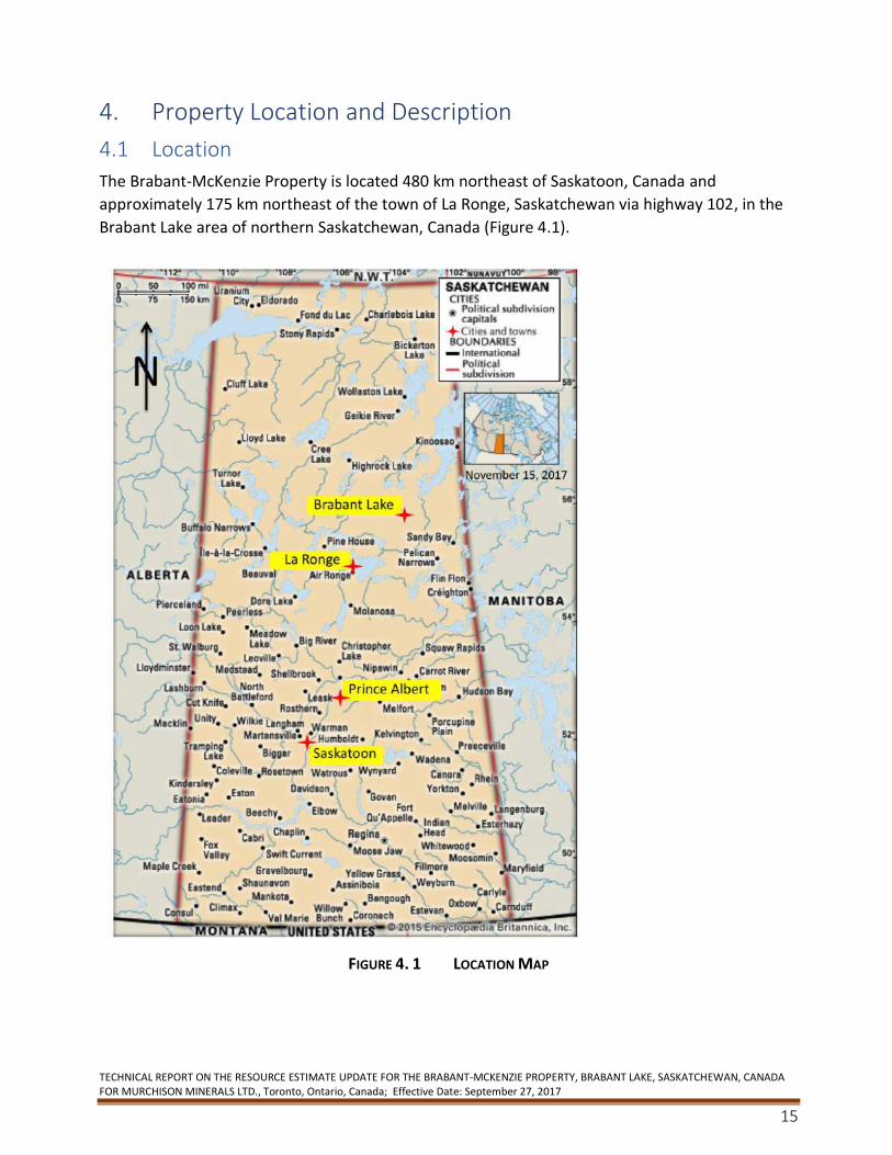
The Brabant-McKenzie Property is located 480 km northeast of Saskatoon, Canada and
approximately 175 km northeast of the town of La Ronge, Saskatchewan via highway 102, in the
Brabant Lake area of northern Saskatchewan, Canada (Figure 4.1).
FIGURE 4. 1 LOCATION MAP
TECHNICAL REPORT ON THE RESOURCE ESTIMATE UPDATE FOR THE BRABANT-MCKENZIE PROPERTY, BRABANT LAKE, SASKATCHEWAN, CANADA FOR MURCHISON MINERALS LTD., Toronto, Ontario, Canada; Effective Date: September 27, 2017
16
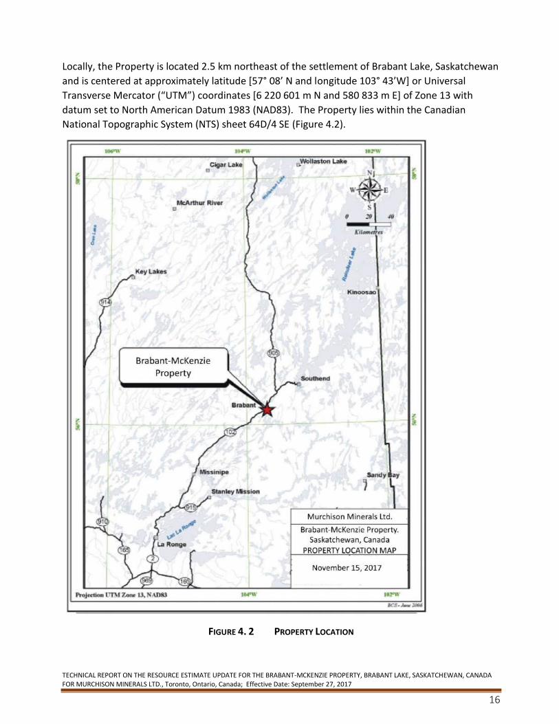
Locally, the Property is located 2.5 km northeast of the settlement of Brabant Lake, Saskatchewan
and is centered at approximately latitude [57° 08’ N and longitude 103° 43’W] or Universal
Transverse Mercator (“UTM”) coordinates [6 220 601 m N and 580 833 m E] of Zone 13 with
datum set to North American Datum 1983 (NAD83). The Property lies within the Canadian
National Topographic System (NTS) sheet 64D/4 SE (Figure 4.2).
FIGURE 4. 2 PROPERTY LOCATION
TECHNICAL REPORT ON THE RESOURCE ESTIMATE UPDATE FOR THE BRABANT-MCKENZIE PROPERTY, BRABANT LAKE, SASKATCHEWAN, CANADA FOR MURCHISON MINERALS LTD., Toronto, Ontario, Canada; Effective Date: September 27, 2017
17
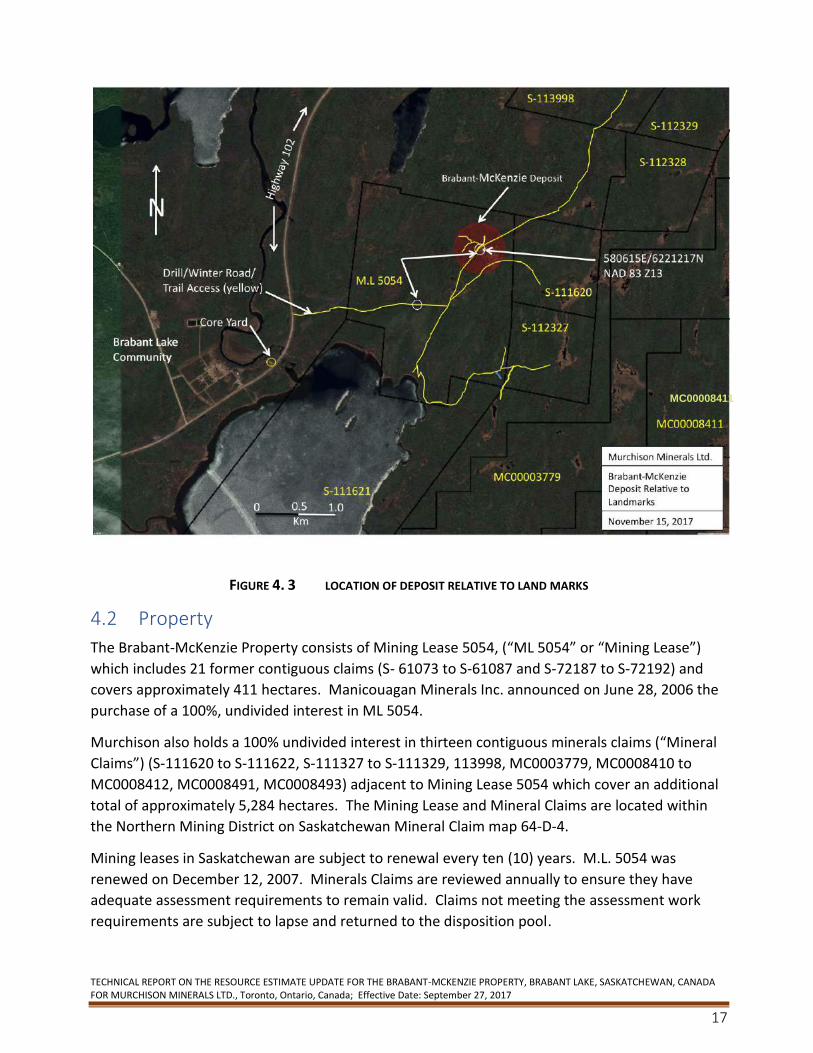
FIGURE 4. 3 LOCATION OF DEPOSIT RELATIVE TO LAND MARKS
4.2 Property
The Brabant-McKenzie Property consists of Mining Lease 5054, (“ML 5054” or “Mining Lease”)
which includes 21 former contiguous claims (S- 61073 to S-61087 and S-72187 to S-72192) and
covers approximately 411 hectares. Manicouagan Minerals Inc. announced on June 28, 2006 the
purchase of a 100%, undivided interest in ML 5054.
Murchison also holds a 100% undivided interest in thirteen contiguous minerals claims (“Mineral
Claims”) (S-111620 to S-111622, S-111327 to S-111329, 113998, MC0003779, MC0008410 to
MC0008412, MC0008491, MC0008493) adjacent to Mining Lease 5054 which cover an additional
total of approximately 5,284 hectares. The Mining Lease and Mineral Claims are located within
the Northern Mining District on Saskatchewan Mineral Claim map 64-D-4.
Mining leases in Saskatchewan are subject to renewal every ten (10) years. M.L. 5054 was
renewed on December 12, 2007. Minerals Claims are reviewed annually to ensure they have
adequate assessment requirements to remain valid. Claims not meeting the assessment work
requirements are subject to lapse and returned to the disposition pool.
MC00008411

TECHNICAL REPORT ON THE RESOURCE ESTIMATE UPDATE FOR THE BRABANT-MCKENZIE PROPERTY, BRABANT LAKE, SASKATCHEWAN, CANADA FOR MURCHISON MINERALS LTD., Toronto, Ontario, Canada; Effective Date: September 27, 2017
18
Assessment credits must be filed annually for mining leases and mineral claims and excess credits
may be banked. An assessment work commitment for mining leases of $75/hectare per annum is
required in order to maintain tenure. Alternatively [for ML. 5054] a deficiency deposit of
$6,680.46 may be paid in lieu of work.
Assessment work commitments for minerals claims is as follows: NIL during the first annual
assessment work period; $15.00 per hectare per assessment work period, from the second to
tenth assessment work periods with a minimum of $240.00 per claim per assessment work
period; $25.00 per hectare per assessment work period, for the eleventh assessment work period
and all subsequent assessment work periods with a minimum of $400.00 per claim per
assessment work period.
Alternatively, a deficiency deposit or non-refundable deficiency payment in lieu of in the amount
equivalent to the assessment deficiency may be paid. If the Company pays a deficiency cash
deposit and expends the amount required for the assessment work period that follows the
assessment work period in which the deficiency was incurred in addition to an amount at least
equal to the deficiency cash deposit, the deficiency cash deposit shall be refunded to the holder
following registration of the expenditure.
At the effective date of this report, Mineral Disposition MC0003779 had an assessment deficiency
of $14,097.02. On June 29, 2017 Murchison made an application for a 60-day extension of time to
September 29, 2017 to complete the required assessment work on MC0003779. A deficiency
payment of $2,253 for extension of time was made to and accepted by the Saskatchewan Land
Tenure Department. An assessment report and evidence of assessment expenditures must be
filed by November 29, 2017. As of the September 29, 2017 the required amounts were expended
by the Company on MC0003779.
A number of Minerals Dispositions have assessment credits which extend beyond 2017. Company
currently plans to continue keeping all its Mineral Dispositions in good standing beyond 2017.
The Company is renewing Mining Lease 5054 for an additional ten (10) years prior to the
December 12, 2017 expiry date as per the Mineral Tenure Act requirements for mining leases.
TECHNICAL REPORT ON THE RESOURCE ESTIMATE UPDATE FOR THE BRABANT-MCKENZIE PROPERTY, BRABANT LAKE, SASKATCHEWAN, CANADA FOR MURCHISON MINERALS LTD., Toronto, Ontario, Canada; Effective Date: September 27, 2017
19
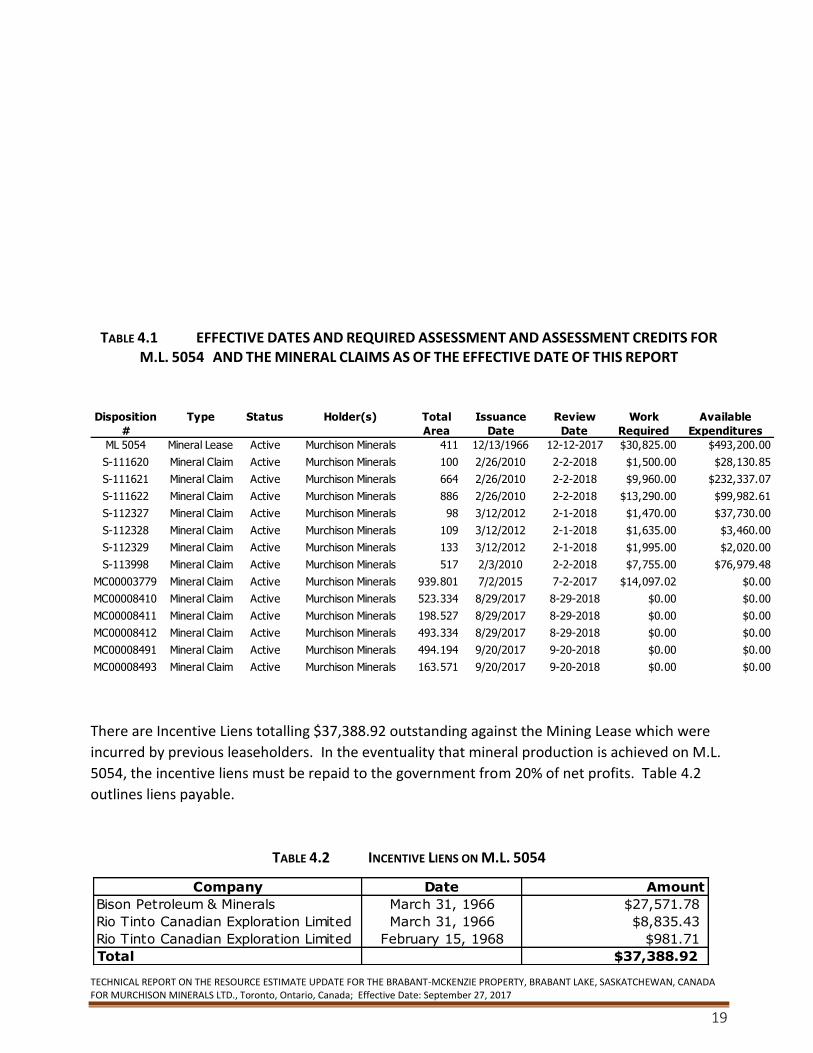
TABLE 4.1 EFFECTIVE DATES AND REQUIRED ASSESSMENT AND ASSESSMENT CREDITS FOR
M.L. 5054 AND THE MINERAL CLAIMS AS OF THE EFFECTIVE DATE OF THIS REPORT
There are Incentive Liens totalling $37,388.92 outstanding against the Mining Lease which were
incurred by previous leaseholders. In the eventuality that mineral production is achieved on M.L.
5054, the incentive liens must be repaid to the government from 20% of net profits. Table 4.2
outlines liens payable.
TABLE 4.2 INCENTIVE LIENS ON M.L. 5054
Status Total
Area
Active 411
Active 100
Active 664
Active 886
Active 98
Active 109
Active 133
Active 517
Active 939.801
Active 523.334
Active 198.527
Active 493.334
Active 494.194
Active 163.571 $0.00
MC00008491 Mineral Claim
MC00008493 Mineral Claim Murchison Minerals
Ltd.|100.000
9/20/2017 9-20-2018 $0.00
MC00008412 Mineral Claim Murchison Minerals
Ltd.|100.000
8/29/2017 8-29-2018
$0.00
$0.00
Murchison Minerals
Ltd.|100.000
9/20/2017 9-20-2018 $0.00
$0.00
$0.00
MC00003779 Mineral Claim
$0.00 $0.00
MC00008411 Mineral Claim Murchison Minerals
Ltd.|100.000
8/29/2017 8-29-2018
MC00008410 Mineral Claim Murchison Minerals
Ltd.|100.000
8/29/2017 8-29-2018 $0.00
S-113998 Mineral Claim Murchison Minerals
Ltd.|100.000
2/3/2010 2-2-2018
$0.00
$1,995.00
Murchison Minerals
Ltd.|100.000
7/2/2015 7-2-2017 $14,097.02
$2,020.00
$3,460.00
S-112327 Mineral Claim
$7,755.00 $76,979.48
S-112329 Mineral Claim Murchison Minerals
Ltd.|100.000
3/12/2012 2-1-2018
S-112328 Mineral Claim Murchison Minerals
Ltd.|100.000
3/12/2012 2-1-2018 $1,635.00
S-111622 Mineral Claim Murchison Minerals
Ltd.|100.000
2/26/2010 2-2-2018
$37,730.00
$9,960.00
Murchison Minerals
Ltd.|100.000
3/12/2012 2-1-2018 $1,470.00
$232,337.07
$28,130.85
ML 5054 Mineral Lease
$13,290.00 $99,982.61
S-111621 Mineral Claim Murchison Minerals
Ltd.|100.000
2/26/2010 2-2-2018
S-111620 Mineral Claim Murchison Minerals
Ltd.|100.000
2/26/2010 2-2-2018 $1,500.00
Disposition
#
Type Holder(s) Issuance
Date
Review
Date
Work
Required
Available
Expenditures
Murchison Minerals
Ltd.|100.000
12/13/1966 12-12-2017 $30,825.00 $493,200.00
Company Date Amount
Bison Petroleum & Minerals March 31, 1966 $27,571.78
Rio Tinto Canadian Exploration Limited March 31, 1966 $8,835.43
Rio Tinto Canadian Exploration Limited February 15, 1968 $981.71
Total $37,388.92
TECHNICAL REPORT ON THE RESOURCE ESTIMATE UPDATE FOR THE BRABANT-MCKENZIE PROPERTY, BRABANT LAKE, SASKATCHEWAN, CANADA FOR MURCHISON MINERALS LTD., Toronto, Ontario, Canada; Effective Date: September 27, 2017
20
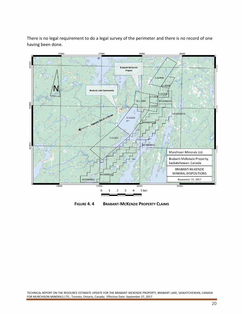
There is no legal requirement to do a legal survey of the perimeter and there is no record of one
having been done.
FIGURE 4. 4 BRABANT-MCKENZIE PROPERTY CLAIMS
TECHNICAL REPORT ON THE RESOURCE ESTIMATE UPDATE FOR THE BRABANT-MCKENZIE PROPERTY, BRABANT LAKE, SASKATCHEWAN, CANADA FOR MURCHISON MINERALS LTD., Toronto, Ontario, Canada; Effective Date: September 27, 2017
21
4.3 History of Claims
4.3.1 Previous Work by Other Parties
The Property’s exploration history, prior to Murchison’s involvement, is summarized below:
1956 Lawrence McKenzie
▪ discovery by prospecting ▪ 15 contiguous claims staked ▪ Property optioned to Paramount Petroleum and Mineral Corporation
Limited and Westore Mines Limited joint venture
1956-58 Paramount-Westore Joint Venture
▪ ground geophysics (mag, EM) ▪ prospecting, trenching ▪ airborne magnetic and electromagnetic surveys ▪ diamond drilling ▪ 39 holes totaling 4,267 m
1959 Saskatchewan Department of Mineral Resources
▪ 1” to ½ mile geological map of Brabant Lake area (Kirkland, 1959)
1964 Bison Petroleum and Minerals Ltd.
▪ diamond drilling ▪ 2 holes totaling 962m ▪ Property optioned to Rio Tinto Canadian Exploration Limited
1965-66 Rio Tinto Canadian Exploration Limited
▪ diamond drilling ▪ 15 holes totaling 3,686 m
1970 Saskatchewan Department of Energy and Mines
▪ soil and rock geochemical survey, Brabant Lake area (Johnston, 1972)
1978 Geological Survey of Canada
▪ -Pb-Pb isotope analysis of one galena sample (Sangster, 1978)
TECHNICAL REPORT ON THE RESOURCE ESTIMATE UPDATE FOR THE BRABANT-MCKENZIE PROPERTY, BRABANT LAKE, SASKATCHEWAN, CANADA FOR MURCHISON MINERALS LTD., Toronto, Ontario, Canada; Effective Date: September 27, 2017
22
1984 Bison Petroleum and Minerals Limited
▪ -ground geophysics ▪ mag, VLF-EM (40 km) ▪ biogeochemical (alder twig) survey
1988 Gamsan Resources Ltd.
▪ review of mineral inventory (Hawkins and Neale, 1988) ▪ soil and lithogeochem sampling ▪ trenching ▪ line cutting (100 km) ▪ ground geophysics ▪ HLEM (45 km) ▪ mag, VLF (96.4 km)
1988-89 Gamsan Resources Ltd.
▪ diamond drilling ▪ 18 holes totaling 3,716 m ▪ updated mineral inventory calculation (Hawkins and Naas, 1989)
1989 Gamsan Resources Ltd.
▪ detailed geological mapping ▪ soil sampling (b-horizon, humus)
1992 Phelps Dodge Corporation of Canada, Limited
▪ line cutting (47 km) -ground geophysics ▪ HLEM (27 km)
1992 Phelps Dodge Corporation of Canada, Limited
▪ line cutting (47 km) ▪ ground geophysics ▪ LEM (27 km)
1993 Phelps Dodge Corporation of Canada, Limited
▪ diamond drilling of geophysical/geochemical anomalies outside of McKenzie Deposit area (Durocher, 1993a)
▪ 7 holes totaling 820.0m ▪ no base metals intersected -detailed geological mapping in the vicinity of McKenzie
Deposit (Barclay, 1993)
TECHNICAL REPORT ON THE RESOURCE ESTIMATE UPDATE FOR THE BRABANT-MCKENZIE PROPERTY, BRABANT LAKE, SASKATCHEWAN, CANADA FOR MURCHISON MINERALS LTD., Toronto, Ontario, Canada; Effective Date: September 27, 2017
23
1993 Phelps Dodge Corporation of Canada, Limited (cont’d)
▪ diamond drilling to test depth potential of Upper Zone and existence of Lower Zone (Durocher, 1993b) -4 holes totaling 2,233.0m
▪ bore hole transient domain EM survey ▪ preliminary metallurgical testing ▪ reflected light petrography, electron microprobe analysis and specific gravity
determinations for seven samples (Davison and Davison, 1994) ▪ compilation and re-interpretation of drilling data including preliminary mineral
resource inventory (Deptuck, 1994).
2006 Manicouagan Minerals Inc.
▪ purchased a 100% undivided interest in the Property from Longyear for a one-time payment of $300,000, no advanced or production royalties are owed to Longyear
▪ 35 line-kilometres of Line cutting, grid establishment ▪ ground geophysical surveys including magnetics, horizontal loop electromagnetic
(HLEM) and VLF-EM over the entire grid ▪ HLEM survey successfully delineated one moderate to strong conductor trend
oriented roughly parallel to localized ground magnetic anomalies with trend corresponding to the McKenzie Zone
▪ 20-hole drilling program totaling 7,102.24 m designed to twin certain higher-grade intersections from previous drilling and to expand upon the known resource
▪ diamond drill holes completed intersected both the Upper and Lower mineralized zones -continuity of the mineralization confirmed. than previously interpreted (Chamois, 2007).
▪ completed NI 43-101 TECHNICAL REPORT ON THE BRABANT LAKE PROPERTY, SASKATCHEWAN, CANADA FOR MANICOUAGAN MINERALS INC. September 15, 2006
2007 Crone Geophysics and Exploration Ltd.
▪ bore hole electromagnetic surveying nine holes surveyed either partially or totally
2007-2008 Manicouagan Minerals Inc.
▪ completed a drilling Phase II program consisting of 29 holes totaling 8,257.78 m ▪ completed NI 43-101 2008 SECOND TECHNICAL REPORT ON THE BRABANT LAKE
Property, SASKATCHEWAN, CANADA FOR MANICOUAGAN MINERALS INC. September 8, 2008
2010 Manicouagan Minerals Inc.
▪ expanded the Property to 2,850 ha which covers approximately 15 kilometres of the favourable geological horizon which hosts the Deposit
TECHNICAL REPORT ON THE RESOURCE ESTIMATE UPDATE FOR THE BRABANT-MCKENZIE PROPERTY, BRABANT LAKE, SASKATCHEWAN, CANADA FOR MURCHISON MINERALS LTD., Toronto, Ontario, Canada; Effective Date: September 27, 2017
24
2011 Manicouagan Minerals Inc.
▪ completed a detailed 560-line kilometres airborne VTEM PLUS geophysical survey which covered the entire of 2,850 ha land package including the Deposit
▪ identified a number of VTEM conductor anomalies in the survey and plate modeled as potential diamond drill targets
▪ Property optioned to Votorantim Metals Canada (“Votorantim”)
2012 Votorantim
▪ completed a 12-hole diamond drill program totalling 2,430 metres designed to test 10 VTEM conductor anomalies
4.3.2 Previous Work by Murchison Minerals
In June 2015, Murchison staked an additional 940 hectares adjacent to its 2,850 hectares on the
Property. The area was considered to be prospective for zinc-copper because it covers EM
conductor trends identified in the 2011 VTEM survey, but are located outside the original
boundary of the Property.
From October 6-10 and 14-21, 2015, Murchison conducted 2 field investigations and data
compilation on the Brabant-McKenzie Property. The premise of the field investigations was as
follows:
• confirm known drill collars, grid locations, access routes and showings on M. L. 5054 and proximal ground for quality control purposes, geo-rectifying existing data and planning of future exploration programs;
• assess ground conditions, styles of mineralization and conductive properties from core
and trenches for modelling and future work programs;
• determine structural setting of the known Brabant-McKenzie Deposit and areas proximal
to Deposit;
• obtain an inventory of remaining and accessible core and assess its condition for
geological control purposes;
• meet with government representatives in Regina and La Ronge to review their recent
work and establish contacts as well as to informally introduce Murchison staff to members
of the Brabant Lake community for consultation purposes and to assess the potential for
local hires.
TECHNICAL REPORT ON THE RESOURCE ESTIMATE UPDATE FOR THE BRABANT-MCKENZIE PROPERTY, BRABANT LAKE, SASKATCHEWAN, CANADA FOR MURCHISON MINERALS LTD., Toronto, Ontario, Canada; Effective Date: September 27, 2017
25
Murchison spent time in October field checking and compiling historical data for the area
surrounding the Brabant-McKenzie Deposit itself and area of modeled VTEM geophysics
conductors along strike of the Deposit. These target areas were presumed to be in the same
geological formation as the Deposit and located on the western limb of a regional fold structure;
likely located within a tight isoclinal Z fold structure that strikes NE dips 50 degrees NW and
plunges to the north.
Field work consisted of checking as many old drill collars (with casing) and grid lines (stations) as
possible in order to geo-reference old historical geology and geophysical data as well as obtaining
a higher confidence level in the actual collar locations versus the locations on the drill hole model.
The locations of more than 20 collars, based on pre-determined GPS coordinates, gave a high
confidence level in their location. All pertinent site visits were marked by GPS and flagged for
future reference.
Old historical maps were digitized with conductor trends from both VTEM and HLEM surveys and
these trends were prospected which led to the re-discovery of six older trenches, some likely
dating back to the 1950s-1960s. These excavated areas are important as they appear to define
the footwall contact zone to the Lower Mineralized Zone deposit as outlined in geological drill
hole modelling by Murchison. The exposures revealed semi-massive to fracture filled and
disseminated pyrrhotite, pyrite, galena, sphalerite and chalcopyrite with local graphite in both
pegmatite dykes (late) and host rock gneisses. The detection of these sites was incorporated into
the geological model as the mineralized footwall contact zone to the Deposit.
In December 2015, the Company conducted a limited ground fixed loop Time Domain
Electromagnetic (“TDEM”) and magnetic ground survey over 200 metres of the southern portion
of the Deposit and a further 600 metres along strike to the south along 100-meter spaced lines.
The geophysics program was designed to test the Deposit’s southern extension. The program
included one line of SQUID EM.
In 2016, Murchison conducted a borehole EM geophysics survey on five previously drilled holes
designed to continue testing the lateral and down dip extents of the Deposit. The survey was
successful in identifying numerous conductive electromagnetic targets that are coincident with
thicker zones of the Deposit and areas with little or no testing by previous drilling immediately
adjacent to the Mineralized Zones.
The Company also conducted a Helicopter Airborne Sub Audio Magnetics (“HeliSAM”) geophysics
survey which covered the main Deposit, Mining Lease and claims immediately adjacent the
Mining Lease. Interpretation of the data suggests that the Deposit has a down dip extent of
approximately 1,000 metres while historic drilling of the Deposit had identified VMS style
mineralization to a current down dip depth extent of 520 metres. Results also indicated that in
addition to the Deposit conductor, two new large discrete conductors were identified
approximately 1.5 kilometres southwest (Anomaly C) and 1.4 kilometres due south (Anomaly D)
of the Deposit. Neither target has been drill tested.
TECHNICAL REPORT ON THE RESOURCE ESTIMATE UPDATE FOR THE BRABANT-MCKENZIE PROPERTY, BRABANT LAKE, SASKATCHEWAN, CANADA FOR MURCHISON MINERALS LTD., Toronto, Ontario, Canada; Effective Date: September 27, 2017
26
The Company completed a follow-up ground SQUID EM geophysics program in February 2017
over Anomaly C and Anomaly D HeliSAM conductor anomalies. Results from the EM and Mag
data indicate that Anomaly C represents a discrete conductive body and a confirmed drill target
with modeled EM plate dimensions measuring 1.4 km by 1.3 km. The conductive body occurs at
approximately 260 m depth from surface within the same geological horizon as the Deposit.
Anomaly D is identified as a significantly large, very intense conductive body and is located on the
southeastern edge of the EM survey grid. Modeled plate dimensions measure a 1 km strike length
by 2- 3 km depth extents with the top edge of the plate at about 145 m from surface. The
conductivity of this body is measured at approximately 1,300 Siemens. By comparison, the
Deposit, which outcrops at surface, has a conductive range of 800 to 1,000 Siemens and current
dimensions of 1 km of strike length and 520 m of depth extent.
A geological prospecting program in the area of the Anomaly D surface expression was successful
in identifying outcrop exposures of approximately 150 m in strike length and containing sulphide
mineralization of chalcopyrite and pyrrhotite. The evidence of surface mineralization and its
proximity to the conductive body combined with the size and conductivity of the EM body is
considered significant and presents the potential for a sizeable sulphide body.
In February and March 2017, Murchison Minerals completed a 5,600 m, 10-hole drill program
designed to test both the lateral and depth extents of the Deposit outside of the 2008, NI 43-101
resource estimate and away from the main central corridor of historic drilling. Volcanogenic
Massive Sulphide (VMS) style zinc-copper mineralization, was intersected in all ten holes. The
results from the program were successful in adding tonnage to the Deposit’s resource estimate
while extending the down dip continuity of the Deposit to approximately 610 metres from
surface. Drilling also confirmed VMS mineralization at a down dip extent of 950 metres from
surface.
Results from the 2017 drilling program and the historic drilling were used to estimate a new
resource for the Deposit. Diamond drilling by Murchison in 2017 is discussed in section 10.
4.4 Environment and Socio-Economic Issues
4.4.1 Environmental Liabilities
The author is not aware of any existing environmental liabilities on the Property.
4.4.2 Treaty
M.L. 5054 was located within, and completely surrounded by Crown Reserve #656, Block #4 (“C.R.
656”) (Figure 4.4). C.R. 656 was subject to the Treaty Land Entitlement Program whereby money
is made available to certain treaty Indian Bands to buy private and/or Crown lands to be
designated as reserves as redress for unfulfilled treaty obligations. The Peter Ballantyne Cree
Nation (the “First Nation”) made application in 1994 to purchase certain crown resource land,

TECHNICAL REPORT ON THE RESOURCE ESTIMATE UPDATE FOR THE BRABANT-MCKENZIE PROPERTY, BRABANT LAKE, SASKATCHEWAN, CANADA FOR MURCHISON MINERALS LTD., Toronto, Ontario, Canada; Effective Date: September 27, 2017
27
including C.R. 656. The sale of C.R. 656 to the First Nation was subject to certain conditions, one
being that the owner of any mineral rights must consent to the sale.
At the time if Manicouagan did not consent to a sale, it would have continued to hold the mineral
lease but M.L. 5054 would have been totally surrounded by a reserve. Agreements relating to
surface access that are less than one year can be entered into with the Province of Saskatchewan.
Agreements longer than one year must have the prior consent of the First Nation.
The Peter Ballantyne Cree Nation did not advance the acquisition and transfer process to acquire
C.R. 656 at the time the application was made in 1994 or was it advanced during that time
through to November 2009. During this period, the First Nation could continue to re-select C.R.
656 every 18 months for acquisition. The Crown Reserve 656, Block 4 remained under active
claim until November 2009 at which time it was removed from Disposition Claim restriction and
the area became open for disposition staking.
4.5 Surface Rights
M.L. 5054 and the adjacent claims do not include surface rights, which are owned by the Crown.
4.6 Work Permits
Prior to the initiation of field work, a Work Authorization Permit (or “WAP”) must be submitted to
Saskatchewan Ministry of Environment outlining the timing, location, type and scope of work to
be performed. A closure report may be required upon termination of the work, depending on the
nature and extent of the proposed work. An application to Saskatchewan Heritage Branch is
required with respect to areas of planned work. The Heritage Branch provides guidance on areas
of cultural and archeologically sensitive sites. More information regarding the WAP best practices
in Saskatchewan is available on the Saskatchewan Business and Industry web site
(http://www.saskatchewan.ca/business/agriculture-natural-resources-and-industry/mineral-
exploration-and-mining).
5. Accessibility, Climate, Local Resources, Infrastructure, and Physiography
5.1 Accessibility
The Property is located 2.5 km northeast of the settlement of Brabant Lake, Saskatchewan, which
in turn is located about 175 km by road north of the town of La Ronge along Provincial Highway
102. This all-weather gravel road passes to within 1 km west of the Property. Year-round access
to the Property is via an approximately 2 km long bulldozed winter/drill road from Highway 102 at
a point just north of the settlement of Brabant Lake, about 500 m north of the Waddy River.
Alternatively, a winter/drill road leads north-easterly across the Property from a point at the
northeast corner of Brabant Bay.
TECHNICAL REPORT ON THE RESOURCE ESTIMATE UPDATE FOR THE BRABANT-MCKENZIE PROPERTY, BRABANT LAKE, SASKATCHEWAN, CANADA FOR MURCHISON MINERALS LTD., Toronto, Ontario, Canada; Effective Date: September 27, 2017
28
5.2 Climate
The Property is located within the Northern Forest ecological region as defined in Marshall and
Schut (1999). The region is classified as having a sub-humid, high- to mid- boreal ecoclimate
marked by short, cool summers and long, very cold winters. From the period 2007 to 2017, the
mean monthly temperatures range from -20° C in January to 17°C in July. Extreme maximum
temperatures for the same period are 0.5°C to 3.0°C in January and up to 35°C in July. Extreme
minimum temperatures for these months were -43.5°C and -0.4°C, respectively, during the
period. The mean annual precipitation at Brabant Lake is 530mm. In excess of 250 mm of snow
remains for a period of 160 days and the median depth of maximum snow cover is about 500 mm.
Lakes are usually frozen until May and freeze-up generally begins in early November. Exploration
and development can be carried out year-round.
5.3 Local Resources and Infrastructure
The community of Brabant Lake is located 175 northeast of La Ronge Saskatchewan. The
Brabant-McKenzie Deposit is located approximately 2.5 km from the community via Highway 102
and an bulldozed access drill road. Provincial Highway 102 passes by Brabant Lake and within 1
km west of the Property. The highway is an all-weather road which services communities further
north from Brabant Lake including Southend and Wollaston Lake as well as access into the
Athabasca Basin.
According to StatsCan the population of Brabant Lake is about 62. Local accommodations, food
and fuel are available at an outfitter’s camp in Brabant Lake.
Grid power provides electricity to Brabant Lake and communities along the highway from La
Ronge north past Brabant Lake, as well as other mining operations in the area. Additionally, large
transmission lines run though the area approximately 15 km south of Brabant Lake and provides
power to mining operations in the Athabasca Basin.
La Ronge is the largest community and service area in northern Saskatchewan. It has a population
of 3,500 in the town itself, about 2,000 people on the adjacent First Nations lands of the Lac La
Ronge Indian Band and some 1,000 people residing in the bordering settlement of Air Ronge. It is
serviced by daily scheduled flights and truck transport.
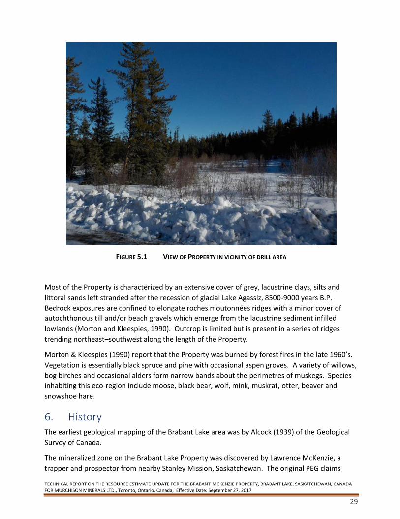
5.4 Physiography, Flora and Fauna
The Property has a base elevation of 486 masl. It is characterized by generally flat topography
interrupted by northeast – southwest trending elongated outcrop ridges having a local relief of
about 10 -25 m (Figure 5-1).
TECHNICAL REPORT ON THE RESOURCE ESTIMATE UPDATE FOR THE BRABANT-MCKENZIE PROPERTY, BRABANT LAKE, SASKATCHEWAN, CANADA FOR MURCHISON MINERALS LTD., Toronto, Ontario, Canada; Effective Date: September 27, 2017
29
FIGURE 5.1 VIEW OF PROPERTY IN VICINITY OF DRILL AREA
Most of the Property is characterized by an extensive cover of grey, lacustrine clays, silts and
littoral sands left stranded after the recession of glacial Lake Agassiz, 8500-9000 years B.P.
Bedrock exposures are confined to elongate roches moutonnées ridges with a minor cover of
autochthonous till and/or beach gravels which emerge from the lacustrine sediment infilled
lowlands (Morton and Kleespies, 1990). Outcrop is limited but is present in a series of ridges
trending northeast–southwest along the length of the Property.
Morton & Kleespies (1990) report that the Property was burned by forest fires in the late 1960’s.
Vegetation is essentially black spruce and pine with occasional aspen groves. A variety of willows,
bog birches and occasional alders form narrow bands about the perimetres of muskegs. Species
inhabiting this eco-region include moose, black bear, wolf, mink, muskrat, otter, beaver and
snowshoe hare.
6. History The earliest geological mapping of the Brabant Lake area was by Alcock (1939) of the Geological
Survey of Canada.
The mineralized zone on the Brabant Lake Property was discovered by Lawrence McKenzie, a
trapper and prospector from nearby Stanley Mission, Saskatchewan. The original PEG claims
TECHNICAL REPORT ON THE RESOURCE ESTIMATE UPDATE FOR THE BRABANT-MCKENZIE PROPERTY, BRABANT LAKE, SASKATCHEWAN, CANADA FOR MURCHISON MINERALS LTD., Toronto, Ontario, Canada; Effective Date: September 27, 2017
30
were staked for a syndicate by M. Murtack and optioned to a joint venture consisting of
Paramount Petroleum Corporation Limited (“Paramount”) and Westore Mines Limited
(“Westore”) in 1956. These companies later merged to become Prairie West Explorations Ltd., a
corporation then controlled by Bison Petroleum and Minerals Ltd. (“Bison”), a subsidiary of
Canadian Javelin Ltd. (“Javelin”).
During 1957-1958, Paramount and Westore completed preliminary exploration consisting of an
airborne magnetic and electromagnetic survey of the surrounding area, five trenches and ground
magnetic and electromagnetic surveys. The trenching revealed a sulphide bearing mineralized
zone varying from 2.2 m to 6.4 m in width (Morton and Kleespies, 1990). This was followed by 39
diamond drill holes for a total of 4,267 m. The drilling tested the McKenzie deposit over a strike
length of about 1,000 m and to vertical depth of about 290 m.
Kirkland (1959) included the Property in his 1:31,360 scale geological map of the Brabant Lake
Area. Byers (1959) examined the Deposit as part of his study of base metal mineralization
associated with pegmatites in northern Saskatchewan. Byers (1962) estimated a historical
resource of 5,052,000 tonnes averaging 4.84% Zn and 0.57% Cu using a 3% combined Cu + Zn
cutoff.
Murchison is not treating the above historical resource estimate as a current mineral resource as
a qualified person has not carried out sufficient work to classify the historical resource estimate
as a current mineral resource and the historical resource should not be relied upon.
In 1964, Bison completed 2 diamond drill holes totalling 962 m. In 1965, Bison commissioned the
Department of Mines and Technical Surveys to run a series of preliminary flotation tests on a
72.73 kg sample of low grade material. The sample was apparently oxidized and, although a
concentrate running 26% Cu with 75% recovery was achieved, difficulty was experienced in
rejecting the Zn from the concentrate (Berry, 1965). In 1964, Bison commissioned the
Department of Mines and Technical Surveys in Ottawa to carry out preliminary flotation testing
on a sample of material from the Property. A 72.73 kg sample of weathered material was
supplied to the Department, the analysis of which yielded 2.28% Zn, 0.66% Cu, 0.55 oz/ton Ag,
and 0.0025 oz/ton Au.
The sample contained disseminated pyrite, chalcopyrite, sphalerite, marcasite, galena and
pyrrhotite along with quartz, feldspar, a fibrous amphibole, biotite and chlorite and minor
goethite.
Despite the oxidized nature of the sample, a series of four flotation tests indicated that copper
concentrates running as high as 26% Cu with recoveries of up to 75% were possible. It was
difficult however to separate the Zn from these concentrates. It was concluded that work on an
unoxidized sample might yield better grades and recoveries of Cu and Zn. It was recommended
that further work be carried out on a higher-grade sample (Berry, 1965).
TECHNICAL REPORT ON THE RESOURCE ESTIMATE UPDATE FOR THE BRABANT-MCKENZIE PROPERTY, BRABANT LAKE, SASKATCHEWAN, CANADA FOR MURCHISON MINERALS LTD., Toronto, Ontario, Canada; Effective Date: September 27, 2017
31
Later in 1965, the Property was optioned to Rio Tinto Canadian Exploration Limited (“Rio Tinto”)
which completed an additional 15 diamond drill holes totaling 3,686 m, the results of which did
not prove sufficiently encouraging (Klemenchuk, 1966).
In 1968, D.M. Knowles estimated an unclassified, “geological and drill indicated” resource of
3,327,000 tonnes averaging 4.42% Zn, 0.64% Cu for Javelin. Knowles identified five apparently
southwesterly plunging shoots within the tabular McKenzie deposit. Also in 1968, S.T.J. Kirkland
estimated an unclassified, “geological and drill indicated” resource of 3,674,000 tonnes grading
4.42% Zn and 0.64% Cu (Morton and Kleespies, 1990).
Murchison is not treating these historical resource estimates as NI 43-101 defined resources (or
reserves). The qualified person has not done sufficient work to classify the historical estimate as
current mineral resources.
In 1970, W.G.Q. Johnston of the Saskatchewan Department of Mineral Resources covered the
Property as part of a regional soil survey. A Zn-Cu soil anomaly coincided with the Deposit. A
second anomaly measuring 350 m long by 120 m wide was identified to the southeast of the
deposit. The results of the survey, as well as a geology map of the Brabant-McKenzie deposit,
were published in 1972.
Sangster (1978) included a sample of galena from the Deposit in a larger study of lead ores of the
circum-Kisseynew volcanic belt.
In 1984, Mr. A.M. Frew was contracted by Bison to carry out ground magnetic and VLF-EM
surveys over 40-line km. A strong VLF-EM conductor coincident with the 350 m x 120 m Zn-Cu
soil anomaly outlined by Johnston (1972) was identified and interpreted to represent a possible
extension to the Deposit. The VLF-EM conductors identified at that time were further
investigated with a biogeochemical survey using the gold content in alder twigs (Morton and
Kleespies, 1990).
In 1988, Gamsan Resources Ltd. (“Gamsan”) purchased Prairie West Explorations Ltd. (Prairie
West) from United Bison Resources Ltd. Prairie West’s only asset was the Brabant-McKenzie
Property. Gamsan commissioned MPH to prepare an independent assessment and summary of
all existing databases. Hawkins and Neale (1988) concluded that the historical resource
calculations of Knowles (1968) and Kirkland (1968) were acceptable with regard to methodology,
and that potential existed for the delineation of additional mineralization.
Gamsan initiated their groundwork with a modest program of soil and lithogeochemical sampling
followed by some trenching. Subsequently a new 100-line km grid was cut and ground
geophysical surveys consisting of magnetics (96.4 km), VLF-EM (96.4 km) and HLEM (45 km) were
completed. In December 1988, Gamsan undertook an 18-hole drill program recovering NQ size
core totaling 3,716 m (Chamois, 1992). This program tested the mineralized zone to a vertical
depth of 446 m and along strike for about 500 m (Morton and Kleespies, 1990).
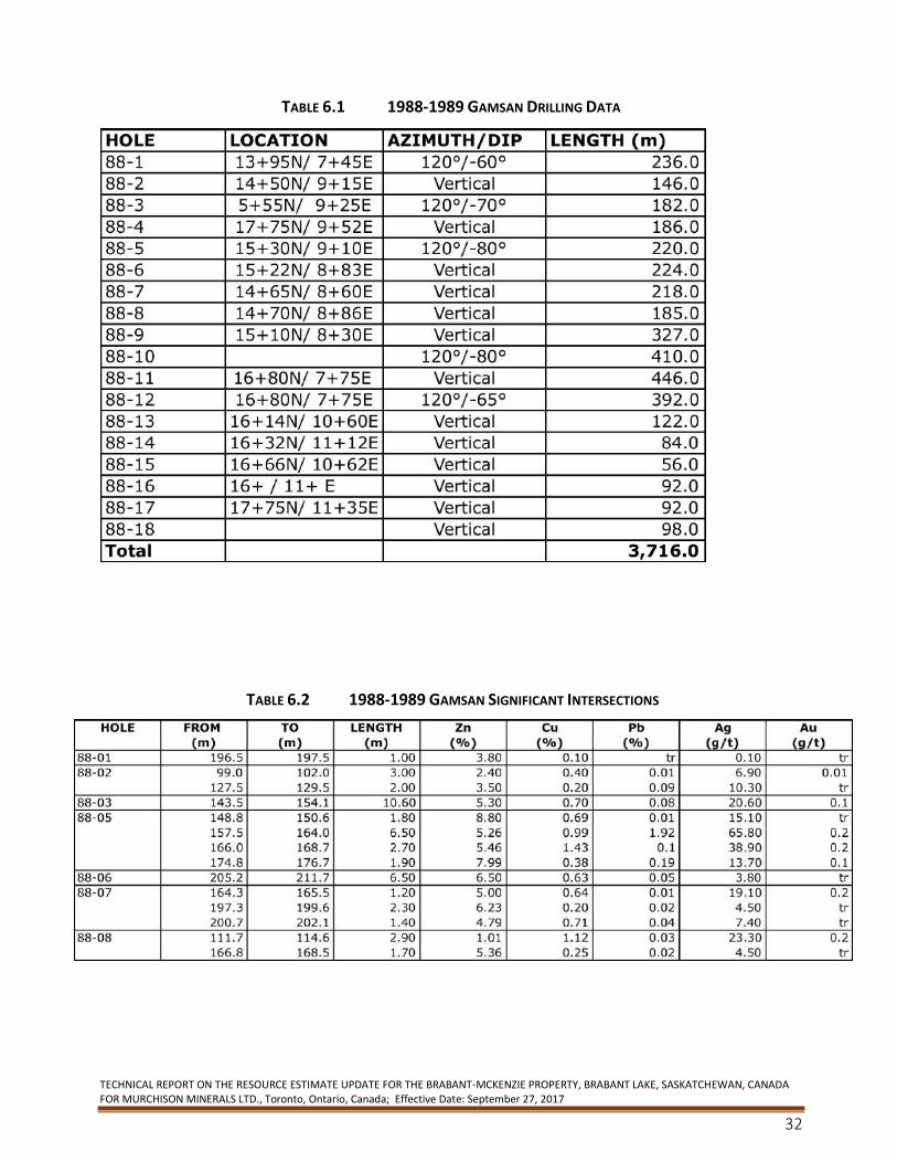
TECHNICAL REPORT ON THE RESOURCE ESTIMATE UPDATE FOR THE BRABANT-MCKENZIE PROPERTY, BRABANT LAKE, SASKATCHEWAN, CANADA FOR MURCHISON MINERALS LTD., Toronto, Ontario, Canada; Effective Date: September 27, 2017
32
TABLE 6.1 1988-1989 GAMSAN DRILLING DATA
TABLE 6.2 1988-1989 GAMSAN SIGNIFICANT INTERSECTIONS

TECHNICAL REPORT ON THE RESOURCE ESTIMATE UPDATE FOR THE BRABANT-MCKENZIE PROPERTY, BRABANT LAKE, SASKATCHEWAN, CANADA FOR MURCHISON MINERALS LTD., Toronto, Ontario, Canada; Effective Date: September 27, 2017
33
TABLE 6.3 1988-1989 GAMSAN SIGNIFICANT INTERSECTIONS CONTD.
In 1989, MPH was contracted to generate a new “geological and drill indicated” mineral resource.
This study estimated an geological and drill indicated resource of 3,489,212 tonnes grading 4.49%
Zn, 0.54% Cu, 0.17% Pb,17.17 g/t Ag and 0.19 g/t Au at a 2% Zn cutoff.
Murchison is not treating the above historical resource estimate as a NI 43-101 defined resource
(or reserve) verified by a qualified person and the historical resource should not be relied upon.
MPH also concluded that the Property had “good potential for an economic polymetallic deposit”
(Hawkins and Naas, 1989). Subsequently, Gamsan completed detailed geological mapping of the
Property as well as an 8-line orientation humus and B-horizon soil sampling program. Based on
the results of the orientation program a larger B-horizon sampling program was completed.
However, because of thick clay/silt cover deposited by glacial Lake Agassiz elsewhere, the survey
was only successful in the south-easterly portion of the Property. The survey successfully
identified the Brabant-McKenzie Deposit as well a lateral strike extension to the southwest as well
as a new anomaly parallel to the Deposit to the southwest (Morton and Kleespies, 1990).
In 1992, Longyear Canada, Inc. (“Longyear”) was awarded title to the Property, pursuant to a
court order, in lieu of payment for work performed.
The Property lay dormant until 1992 when Phelps Dodge Corporation of Canada, Limited (“PDC”)
negotiated an option agreement with Longyear and initiated ground work by re-establishing the
grid (47-line km) and completing a HLEM survey (27-line km). PDC completed a 7-hole drilling
program (NQ size core) totaling 820 m in the spring of 1993 designed to test geophysical targets
HOLE FROM TO LENGTH Zn Cu Pb Ag Au
(m) (m) (m) (%) (%) (%) (g/t) (g/t)
169.5 170.6 1.10 2.38 0.30 0.01 7.00 tr
88-09 209.5 211.0 1.50 0.27 0.01 1.16 17.00 tr
272.1 276.6 4.50 1.56 0.48 0.50 20.40 tr
88-10 339.8 342.0 2.20 5.95 0.67 1.28 52.30 0.50
369.9 373.0 3.10 7.71 2.16 0.79 116.10 0.20
88-11 369.7 373.0 3.30 4.89 0.23 2.06 91.90 0.50
374.0 375.6 1.60 0.38 0.94 1.88 187.00 3.40
381.7 384.4 2.70 0.60 0.50 3.27 198.30 2.90
385.2 387.5 2.30 6.03 0.54 0.35 42.70 1.20
390.0 394.2 4.20 5.99 0.76 0.42 55.30 0.20
397.0 401.3 4.30 0.06 0.10 2.20 79.30 1.80
88-12 288.8 297.7 8.90 2.74 0.38 1.29 74.10 0.70
330.0 341.5 11.50 5.09 0.75 1.35 76.90 1.30
347.4 347.7 0.30 0.03 0.04 5.63 749.50 6.30
88-13 103.7 107.9 4.20 10.60 0.99 0.01 16.00 0.04
88-14 60.0 65.4 5.40 5.64 0.51 tr 8.00 0.04
88-15 36.9 39.2 2.30 2.96 0.31 tr 3.90 0.02
88-16 74.0 78.1 4.10 5.30 1.56 tr 18.67 0.09
88-17 84.2 87.8 3.60 5.23 1.16 tr 18.54 0.20
88-18 63.8 67.2 3.40 2.32 0.29 tr 3.00 0.15
88-18 77.3 80.6 3.30 6.17 2.22 tr 25.60 0.30
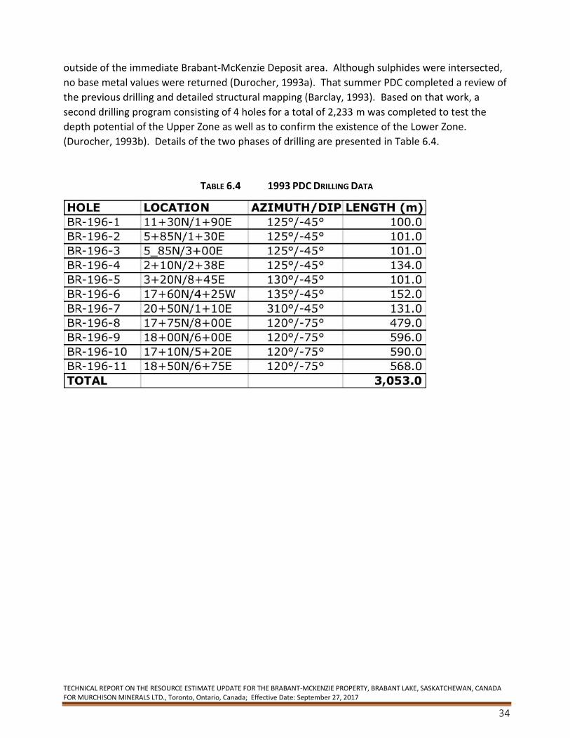
TECHNICAL REPORT ON THE RESOURCE ESTIMATE UPDATE FOR THE BRABANT-MCKENZIE PROPERTY, BRABANT LAKE, SASKATCHEWAN, CANADA FOR MURCHISON MINERALS LTD., Toronto, Ontario, Canada; Effective Date: September 27, 2017
34
outside of the immediate Brabant-McKenzie Deposit area. Although sulphides were intersected,
no base metal values were returned (Durocher, 1993a). That summer PDC completed a review of
the previous drilling and detailed structural mapping (Barclay, 1993). Based on that work, a
second drilling program consisting of 4 holes for a total of 2,233 m was completed to test the
depth potential of the Upper Zone as well as to confirm the existence of the Lower Zone.
(Durocher, 1993b). Details of the two phases of drilling are presented in Table 6.4.
TABLE 6.4 1993 PDC DRILLING DATA
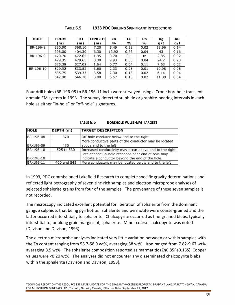
TECHNICAL REPORT ON THE RESOURCE ESTIMATE UPDATE FOR THE BRABANT-MCKENZIE PROPERTY, BRABANT LAKE, SASKATCHEWAN, CANADA FOR MURCHISON MINERALS LTD., Toronto, Ontario, Canada; Effective Date: September 27, 2017
35
TABLE 6.5 1933 PDC DRILLING SIGNIFICANT INTERSECTIONS
Four drill holes (BR-196-08 to BR-196-11 incl.) were surveyed using a Crone borehole transient
domain EM system in 1993. The survey detected sulphide or graphite-bearing intervals in each
hole as either “in-hole” or “off-hole” signatures.
TABLE 6.6 BOREHOLE PULSE-EM TARGETS
In 1993, PDC commissioned Lakefield Research to complete specific gravity determinations and
reflected light petrography of seven zinc-rich samples and electron microprobe analyses of
selected sphalerite grains from four of the samples. The provenance of these seven samples is
not recorded.
The microscopy indicated excellent potential for liberation of sphalerite from the dominant
gangue sulphide, that being pyrrhotite. Sphalerite and pyrrhotite were coarse-grained and the
latter occurred interstitially to sphalerite. Chalcopyrite occurred as fine-grained blebs, typically
interstitial to, or along grain margins of, sphalerite. Minor coarse chalcopyrite was noted
(Davison and Davison, 1993).
The electron microprobe analyses indicated very little variation between or within samples with
the Zn content ranging from 56.7-58.9 wt%, averaging 58 wt%. Iron ranged from 7.82-9.67 wt%,
averaging 8.5 wt%. The sphalerite composition reported as marmatitic (Zn0.85Fe0.15S). Copper
values were <0.20 wt%. The analyses did not encounter any disseminated chalcopyrite blebs
within the sphalerite (Davison and Davison, 1993).
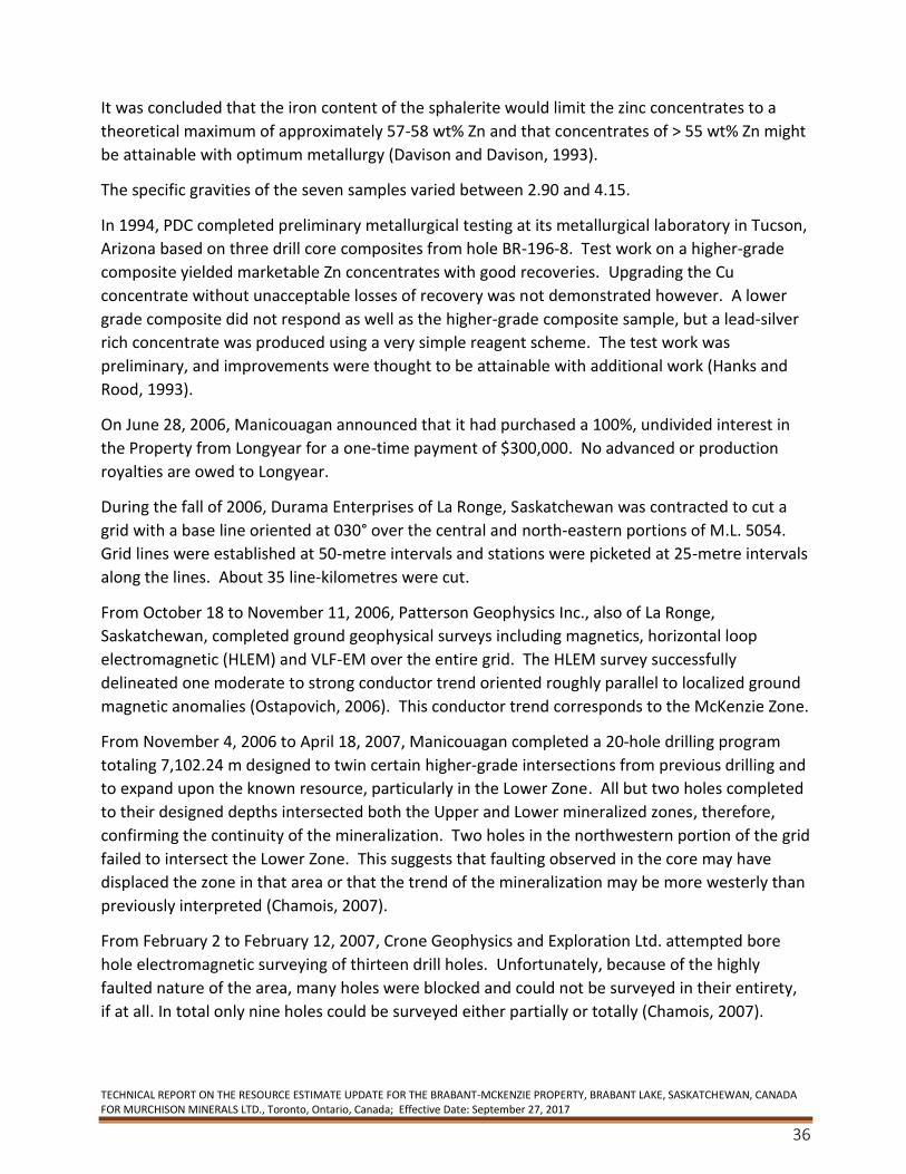
TECHNICAL REPORT ON THE RESOURCE ESTIMATE UPDATE FOR THE BRABANT-MCKENZIE PROPERTY, BRABANT LAKE, SASKATCHEWAN, CANADA FOR MURCHISON MINERALS LTD., Toronto, Ontario, Canada; Effective Date: September 27, 2017
36
It was concluded that the iron content of the sphalerite would limit the zinc concentrates to a
theoretical maximum of approximately 57-58 wt% Zn and that concentrates of > 55 wt% Zn might
be attainable with optimum metallurgy (Davison and Davison, 1993).
The specific gravities of the seven samples varied between 2.90 and 4.15.
In 1994, PDC completed preliminary metallurgical testing at its metallurgical laboratory in Tucson,
Arizona based on three drill core composites from hole BR-196-8. Test work on a higher-grade
composite yielded marketable Zn concentrates with good recoveries. Upgrading the Cu
concentrate without unacceptable losses of recovery was not demonstrated however. A lower
grade composite did not respond as well as the higher-grade composite sample, but a lead-silver
rich concentrate was produced using a very simple reagent scheme. The test work was
preliminary, and improvements were thought to be attainable with additional work (Hanks and
Rood, 1993).
On June 28, 2006, Manicouagan announced that it had purchased a 100%, undivided interest in
the Property from Longyear for a one-time payment of $300,000. No advanced or production
royalties are owed to Longyear.
During the fall of 2006, Durama Enterprises of La Ronge, Saskatchewan was contracted to cut a
grid with a base line oriented at 030° over the central and north-eastern portions of M.L. 5054.
Grid lines were established at 50-metre intervals and stations were picketed at 25-metre intervals
along the lines. About 35 line-kilometres were cut.
From October 18 to November 11, 2006, Patterson Geophysics Inc., also of La Ronge,
Saskatchewan, completed ground geophysical surveys including magnetics, horizontal loop
electromagnetic (HLEM) and VLF-EM over the entire grid. The HLEM survey successfully
delineated one moderate to strong conductor trend oriented roughly parallel to localized ground
magnetic anomalies (Ostapovich, 2006). This conductor trend corresponds to the McKenzie Zone.
From November 4, 2006 to April 18, 2007, Manicouagan completed a 20-hole drilling program
totaling 7,102.24 m designed to twin certain higher-grade intersections from previous drilling and
to expand upon the known resource, particularly in the Lower Zone. All but two holes completed
to their designed depths intersected both the Upper and Lower mineralized zones, therefore,
confirming the continuity of the mineralization. Two holes in the northwestern portion of the grid
failed to intersect the Lower Zone. This suggests that faulting observed in the core may have
displaced the zone in that area or that the trend of the mineralization may be more westerly than
previously interpreted (Chamois, 2007).
From February 2 to February 12, 2007, Crone Geophysics and Exploration Ltd. attempted bore
hole electromagnetic surveying of thirteen drill holes. Unfortunately, because of the highly
faulted nature of the area, many holes were blocked and could not be surveyed in their entirety,
if at all. In total only nine holes could be surveyed either partially or totally (Chamois, 2007).
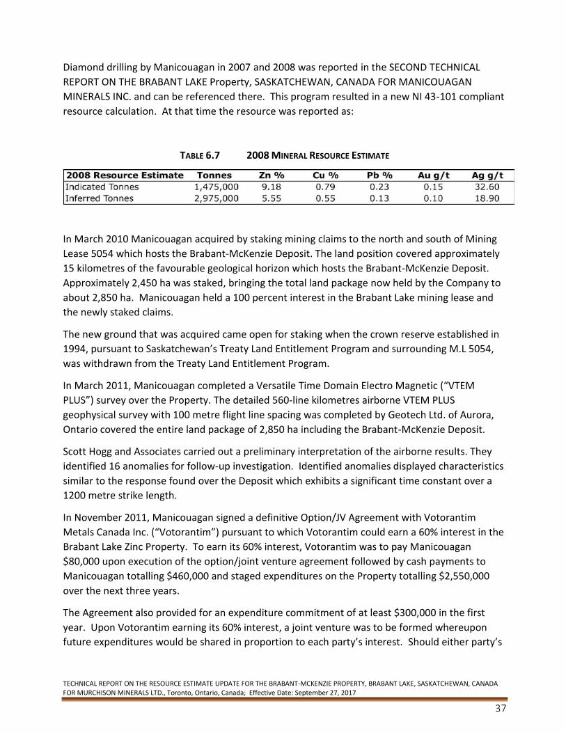
TECHNICAL REPORT ON THE RESOURCE ESTIMATE UPDATE FOR THE BRABANT-MCKENZIE PROPERTY, BRABANT LAKE, SASKATCHEWAN, CANADA FOR MURCHISON MINERALS LTD., Toronto, Ontario, Canada; Effective Date: September 27, 2017
37
Diamond drilling by Manicouagan in 2007 and 2008 was reported in the SECOND TECHNICAL
REPORT ON THE BRABANT LAKE Property, SASKATCHEWAN, CANADA FOR MANICOUAGAN
MINERALS INC. and can be referenced there. This program resulted in a new NI 43-101 compliant
resource calculation. At that time the resource was reported as:
TABLE 6.7 2008 MINERAL RESOURCE ESTIMATE
In March 2010 Manicouagan acquired by staking mining claims to the north and south of Mining
Lease 5054 which hosts the Brabant-McKenzie Deposit. The land position covered approximately
15 kilometres of the favourable geological horizon which hosts the Brabant-McKenzie Deposit.
Approximately 2,450 ha was staked, bringing the total land package now held by the Company to
about 2,850 ha. Manicouagan held a 100 percent interest in the Brabant Lake mining lease and
the newly staked claims.
The new ground that was acquired came open for staking when the crown reserve established in
1994, pursuant to Saskatchewan’s Treaty Land Entitlement Program and surrounding M.L 5054,
was withdrawn from the Treaty Land Entitlement Program.
In March 2011, Manicouagan completed a Versatile Time Domain Electro Magnetic (“VTEM
PLUS”) survey over the Property. The detailed 560-line kilometres airborne VTEM PLUS
geophysical survey with 100 metre flight line spacing was completed by Geotech Ltd. of Aurora,
Ontario covered the entire land package of 2,850 ha including the Brabant-McKenzie Deposit.
Scott Hogg and Associates carried out a preliminary interpretation of the airborne results. They
identified 16 anomalies for follow-up investigation. Identified anomalies displayed characteristics
similar to the response found over the Deposit which exhibits a significant time constant over a
1200 metre strike length.
In November 2011, Manicouagan signed a definitive Option/JV Agreement with Votorantim
Metals Canada Inc. (“Votorantim”) pursuant to which Votorantim could earn a 60% interest in the
Brabant Lake Zinc Property. To earn its 60% interest, Votorantim was to pay Manicouagan
$80,000 upon execution of the option/joint venture agreement followed by cash payments to
Manicouagan totalling $460,000 and staged expenditures on the Property totalling $2,550,000
over the next three years.
The Agreement also provided for an expenditure commitment of at least $300,000 in the first
year. Upon Votorantim earning its 60% interest, a joint venture was to be formed whereupon
future expenditures would be shared in proportion to each party’s interest. Should either party’s
TECHNICAL REPORT ON THE RESOURCE ESTIMATE UPDATE FOR THE BRABANT-MCKENZIE PROPERTY, BRABANT LAKE, SASKATCHEWAN, CANADA FOR MURCHISON MINERALS LTD., Toronto, Ontario, Canada; Effective Date: September 27, 2017
38
interest dilute to 10%, this interest will convert to a 2% Net Smelter Return (“NSR”). The non-
diluting party had the option to purchase 50% of the NSR for $1,000,000.
In May 2012, Votoranim announced it had completed a 12-hole diamond drill program for a total
of 2,430 metres. Votorantim had identified 20 primary drill targets from the 563 line-km airborne
VTEM PLUS survey which Manicouagan conducted over the Property in early 2011.
The drill program was designed to test high priority regional targets on strike from the Deposit.
Previous drilling on the Brabant Lake Property by Manicouagan was concentrated on the Deposit.
10 of the 20 planned targets were drill tested.
After reviewing the results of the drill program, Votorantim elected not to continue its option and
returned the Brabant-McKenzie Property to Manicouagan.
In June 2015, Murchison (Formerly Manicouagan Minerals Inc.) staked an additional 940 hectares,
adjacent to its 3,212 hectares on the Property. The area was considered to be prospective for
zinc-copper because it covered EM conductor trends identified from the 2011 VTEM survey, but
was located outside the original boundary of the Property.
From October 6-10 and 14-21, 2015 Murchison conducted of 2 field investigations and data
compilation on the Brabant-McKenzie Property.
The premise of the field investigations was as follows:
• confirm known drill collars, grid locations, access routes and showings on Mineral Lease
5054 and proximal ground for quality control purposes, geo-rectifying existing data and
planning of future exploration programs;
• assess ground conditions, styles of mineralization and conductive properties from core
and trenches for modelling and future work programs;
• determine structural setting of the known McKenzie deposit and areas proximal to
deposit;
• obtain an inventory of remaining and accessible core and assess its’ condition for
geological control purposes; and
• meet with government representatives in Regina and La Ronge to review their recent
work and establish contacts as well as to informally introduce Murchison staff to members
of the Brabant Lake community for consultation purposes and to assess the potential for
local hires.
Murchison spent time field checking and compiling historical data for the area surrounding the
Brabant-McKenzie deposit itself and area of modeled VTEM geophysics conductors along strike of
the Deposit. These target areas are presumed to be the same geological formation as the Deposit
TECHNICAL REPORT ON THE RESOURCE ESTIMATE UPDATE FOR THE BRABANT-MCKENZIE PROPERTY, BRABANT LAKE, SASKATCHEWAN, CANADA FOR MURCHISON MINERALS LTD., Toronto, Ontario, Canada; Effective Date: September 27, 2017
39
and located on the western limb of the regional fold structure and are likely located within a tight
isoclinal Z fold structure that strikes NE dips 50 degrees NW and plunges to the north.
Field work consisted of checking as many old drill collars (with casing) and grid lines (stations) as
possible in order to be able to geo-reference old historical geology and geophysical data as well as
obtaining a confidence level as to actual collar locations as they pertain to the drill hole model.
Locations of more than 20 collar locations based on pre-determined GPS coordinates gave a high
confidence in their location. All pertinent site visits were GPS marked and flagged for future
reference.
Old historical maps were digitized with conductor trends from both VTEM and HLEM surveys and
these trends were prospected which led to the re-discovery of 6 older trenches, some likely
dating back to the 1950-1960’s. These excavated areas are important as they appear to define
the FW contact zone to the Lower Mineralized Zone of the Deposit as outlined in geological drill
hole modelling by Murchison. The exposures revealed semi-massive to fracture filled and
disseminated pyrrhotite, pyrite, galena, sphalerite and chalcopyrite with local graphite in both
pegmatite dykes (late) and host rock gneisses. The detection of these sites was incorporated into
the geological model as the mineralized footwall contact zone to the Deposit.
In December 2015, Murchison Minerals Ltd conducted a limited ground fixed loop Time Domain
Electromagnetic (“TDEM”) and magnetic ground survey which was conducted over 200 metres of
the southern portion of the Deposit and a further 600 metres along strike to the south along 100-
meter spaced lines. The geophysics program designed to test the Deposit’s southern extension.
The program included one line of SQUID EM.
In 2016, Murchison conducted a borehole EM geophysics survey on five previously drilled holes
designed to continue testing the lateral and down dip extents of the Deposit. The survey was
successful in identifying numerous conductive electromagnetic targets that are coincident with
thicker zones of the Deposit and areas with little or no testing by previous drilling immediately
adjacent to the Mineralized Zones.
The Company also conducted a Helicopter Airborne Sub Audio Magnetics geophysics survey
(“HeliSAM”) which covered the main Deposit, M.L. 5054 and claims immediately adjacent to the
Mining Lease. Interpretation of the data suggests that the Deposit has a down dip extent of
approximately 1,000 metres while historic drilling of the Deposit had identified VMS style
mineralization to a current down dip depth extent of 520 metres. Results also indicated that in
addition to the Deposit conductor, two new large discrete conductors were identified
approximately 1.5 kilometres southwest (Anomaly C) and 1.4 kilometres due south (Anomaly D)
of the Deposit. Neither target has been drill tested.
The Company completed a follow-up ground SQUID EM geophysics program in February 2017
that was conducted over Anomaly C and Anomaly D HeliSAM conductor anomalies.
TECHNICAL REPORT ON THE RESOURCE ESTIMATE UPDATE FOR THE BRABANT-MCKENZIE PROPERTY, BRABANT LAKE, SASKATCHEWAN, CANADA FOR MURCHISON MINERALS LTD., Toronto, Ontario, Canada; Effective Date: September 27, 2017
40
Results from the EM and Mag data indicate that Anomaly C represents a discrete conductive body
and a confirmed drill target with modeled EM plate dimensions measuring 1.4 km by 1.3 km. The
conductive body occurs at approximately 260 m depth from surface within the same geological
horizon as the Deposit.
Anomaly D is identified as a significantly large, very intense conductive body and is located on the
southeastern edge of the EM survey grid. Modeled plate dimensions measure a 1 km strike
length by 2-3 km depth extents with the top edge of the plate at about 145 m from surface. The
conductivity of this body is measured at approximately 1,300 Siemens. By comparison, the
Deposit that outcrops at surface, has a conductive range of 800 to 1,000 Siemens and current
dimensions of 1 km of strike length and 520 m of depth extent.
A geological prospecting program in the area of the Anomaly D modeled EM plate surface
Property in was successful in identifying outcrop exposures of approximately 150 m in strike
length and containing sulphide mineralization of chalcopyrite and pyrrhotite. The evidence of
surface mineralization and its proximity to the conductive body combined with the size and
conductivity of the EM body is considered significant and presents the potential for a sulphide
body of size.
In February and March 2017, Murchison Minerals completed a 5,600 m, 10-hole drill program
designed to test both the lateral and depth extents of the Deposit outside of the 2008, NI 43-101
resource estimate and away from the main central corridor of historic drilling. Volcanogenic
Massive Sulphide (VMS) style zinc-copper mineralization, was intersected by all ten holes of the
recently completed drill program. The results from the program were successful in adding
tonnage to the Deposit while extending its down-dip depth extent to approximately 610 metres
from surface. Additionally, drilling confirmed VMS mineralization at a down-dip extent of 950
metres from surface.
Results from this drilling program and the historic drilling were used to estimate a new resource
for the Deposit. Diamond drilling by Murchison in 2017 is discussed in section 14.
7. Geological Setting and Mineralization
7.1 Regional Geology
The Property is located within the Reindeer Zone of the Early Proterozoic Trans-Hudson Orogen.
The Reindeer Zone in Saskatchewan is a collage of juvenile, arc-related crustal domains
(Rottenstone, La Ronge, Flin Flon, Glennie Lake, Kisseynew and Hanson Lake Block) bounded by
the Rae-Hearn and Archean Superior structural provinces (Figure 7.1). The La Ronge, Flin Flon and
Hanson Lake Block domains represent the vestiges of arc-related volcanism and plutonism in the
Reindeer Zone. These domains broadly envelope the clastic meta-sedimentary dominated inter-
arc Kisseynew Domain. The Glennie Lake domain consists primarily of orthogneisses with lesser
supracrustal gneisses, including minor metavolcanic rocks.
TECHNICAL REPORT ON THE RESOURCE ESTIMATE UPDATE FOR THE BRABANT-MCKENZIE PROPERTY, BRABANT LAKE, SASKATCHEWAN, CANADA FOR MURCHISON MINERALS LTD., Toronto, Ontario, Canada; Effective Date: September 27, 2017
41
The McLennan Lake Tectonic Zone (“MLTZ”) separates the lower metamorphic grade volcanic and
intrusive rocks of the La Ronge Domain (a.k.a. Central Volcanic Belt) (“CVB”) from amphibolite to
granulite facies gneisses of the MacLean Lake Belt (“MLB”) to the east (Figure 7.2). The MLB
consists mainly of paragneisses similar to those of the Kisseynew domain. The MLB is divided into
psammitic (arkosic) gneisses of the McLennan Group which are inferred to overlie the pelitic to
psammitic (greywacke-derived) MacLean Lake Gneisses (Lewry, 1983). Migmatitic gneiss and
other melt-derived units are significant components (up to 50%) and amphibolites and calc-
silicate rocks are minor components of the MLB. The Property is located less than 5 km east of
the MLTZ and straddles the boundary between the McLennan Group and the MacLean Lake
Gneisses (Figure 7.1).
The MLB has undergone a polyphase ductile deformation history. The earliest events (D1 and D2)
are likely related to thrust tectonics, including thrusting in the La Ronge domain over the MLB
along the MLTZ (Lewry, 1983). Primary layering (So) and the earliest tectonic fabric? (S1) are
strongly transposed into the NE-striking, NW-dipping S2 foliation which is axial planar to
recumbent overturned F2 structures. Open, north-trending D3 fold axes east of Brabant Lake
exhibit an axial planar S3 foliation locally. Poulsen et al. (1987) suggest that, although the
downdip lineation found throughout in the MLTZ may attest to earlier recumbent nappe folding
and thrust tectonics as proposed by Lewry (1983), the strain fabrics presently viewed in the MLTZ
record predominantly dextral strike-slip movement.
Although peak metamorphic conditions likely occurred syn-D2 thrusting (Abbas-Hasanie et al.,
1992) and gneissic fabrics are common, many rocks in the MLB exhibit granoblastic textures,
(Durocher, 1992, Barclay 1993). Sillimanite in McLennan Group gneiss is typically to completely
retrogressed adjacent to the MLTZ (Poulsen et al. 1987, Abbas-Hasanie et al. 1992) suggesting
that the transpressive movement on this structure accompanied a retrogressive event which
occurred post-D2.
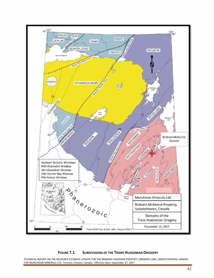
TECHNICAL REPORT ON THE RESOURCE ESTIMATE UPDATE FOR THE BRABANT-MCKENZIE PROPERTY, BRABANT LAKE, SASKATCHEWAN, CANADA FOR MURCHISON MINERALS LTD., Toronto, Ontario, Canada; Effective Date: September 27, 2017
42
FIGURE 7.1 SUBDIVISIONS OF THE TRANS HUDSONIAN OROGENY
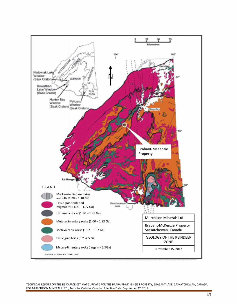
TECHNICAL REPORT ON THE RESOURCE ESTIMATE UPDATE FOR THE BRABANT-MCKENZIE PROPERTY, BRABANT LAKE, SASKATCHEWAN, CANADA FOR MURCHISON MINERALS LTD., Toronto, Ontario, Canada; Effective Date: September 27, 2017
43

TECHNICAL REPORT ON THE RESOURCE ESTIMATE UPDATE FOR THE BRABANT-MCKENZIE PROPERTY, BRABANT LAKE, SASKATCHEWAN, CANADA FOR MURCHISON MINERALS LTD., Toronto, Ontario, Canada; Effective Date: September 27, 2017
44
FIGURE 7.2 GEOLOGY OF THE REINDEER ZONE IN NORTHERN SASKATCHEWAN
7.2 Property Geology
The following is modified from Stewart and Chamois (1994).
The Property is located within the western part of the MLB and straddles the boundary between
the McLean Lake Gneisses and the McLennan Group meta-arkoses. The central portion of the
Property is covered by a thick blanket of Pleistocene to Recent lacustrine sediments with
northeast trending outcrop ridges confined to the northwestern and southeastern quadrants.
The geology of the Property and its immediate surroundings can be found in Kirkland (1959),
Byers (1959), Johnston (1972), Kleespies (1989), Morton and Kleespies (1990) and McCombe et al.
(1991). Barclay (1993) mapped the northern portion of the southeastern outcrop ridge in detail.
Harper (1996, 1997) mapped an area generally to the northeast of, but including parts, of the
Property in an attempt to better define the contact between the CVB and the MLB. Figure 7.3
outlines the Brabant-McKenzie property geology as referenced from the Saskatchewan GeoAltas
Mapping website (November 13, 2017).
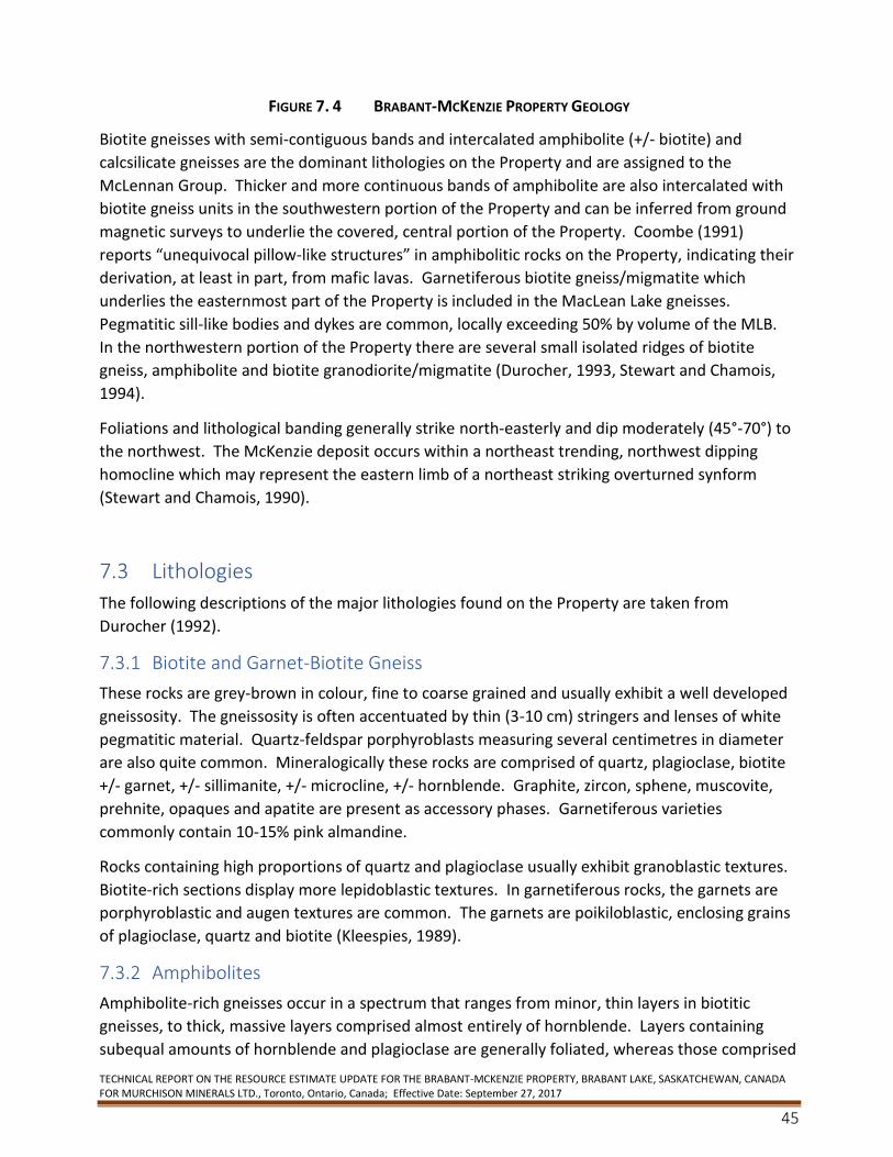
TECHNICAL REPORT ON THE RESOURCE ESTIMATE UPDATE FOR THE BRABANT-MCKENZIE PROPERTY, BRABANT LAKE, SASKATCHEWAN, CANADA FOR MURCHISON MINERALS LTD., Toronto, Ontario, Canada; Effective Date: September 27, 2017
45
FIGURE 7. 4 BRABANT-MCKENZIE PROPERTY GEOLOGY
Biotite gneisses with semi-contiguous bands and intercalated amphibolite (+/- biotite) and
calcsilicate gneisses are the dominant lithologies on the Property and are assigned to the
McLennan Group. Thicker and more continuous bands of amphibolite are also intercalated with
biotite gneiss units in the southwestern portion of the Property and can be inferred from ground
magnetic surveys to underlie the covered, central portion of the Property. Coombe (1991)
reports “unequivocal pillow-like structures” in amphibolitic rocks on the Property, indicating their
derivation, at least in part, from mafic lavas. Garnetiferous biotite gneiss/migmatite which
underlies the easternmost part of the Property is included in the MacLean Lake gneisses.
Pegmatitic sill-like bodies and dykes are common, locally exceeding 50% by volume of the MLB.
In the northwestern portion of the Property there are several small isolated ridges of biotite
gneiss, amphibolite and biotite granodiorite/migmatite (Durocher, 1993, Stewart and Chamois,
1994).
Foliations and lithological banding generally strike north-easterly and dip moderately (45°-70°) to
the northwest. The McKenzie deposit occurs within a northeast trending, northwest dipping
homocline which may represent the eastern limb of a northeast striking overturned synform
(Stewart and Chamois, 1990).
7.3 Lithologies
The following descriptions of the major lithologies found on the Property are taken from
Durocher (1992).
7.3.1 Biotite and Garnet-Biotite Gneiss
These rocks are grey-brown in colour, fine to coarse grained and usually exhibit a well developed
gneissosity. The gneissosity is often accentuated by thin (3-10 cm) stringers and lenses of white
pegmatitic material. Quartz-feldspar porphyroblasts measuring several centimetres in diameter
are also quite common. Mineralogically these rocks are comprised of quartz, plagioclase, biotite
+/- garnet, +/- sillimanite, +/- microcline, +/- hornblende. Graphite, zircon, sphene, muscovite,
prehnite, opaques and apatite are present as accessory phases. Garnetiferous varieties
commonly contain 10-15% pink almandine.
Rocks containing high proportions of quartz and plagioclase usually exhibit granoblastic textures.
Biotite-rich sections display more lepidoblastic textures. In garnetiferous rocks, the garnets are
porphyroblastic and augen textures are common. The garnets are poikiloblastic, enclosing grains
of plagioclase, quartz and biotite (Kleespies, 1989).
7.3.2 Amphibolites
Amphibolite-rich gneisses occur in a spectrum that ranges from minor, thin layers in biotitic
gneisses, to thick, massive layers comprised almost entirely of hornblende. Layers containing
subequal amounts of hornblende and plagioclase are generally foliated, whereas those comprised
TECHNICAL REPORT ON THE RESOURCE ESTIMATE UPDATE FOR THE BRABANT-MCKENZIE PROPERTY, BRABANT LAKE, SASKATCHEWAN, CANADA FOR MURCHISON MINERALS LTD., Toronto, Ontario, Canada; Effective Date: September 27, 2017
46
mainly of hornblende tend to be poorly foliated to massive. Amphibole-rich gneisses also appear
to contain more pyrrhotite than other rock units. Mineralogically these rocks are made up of
amphibole, plagioclase, +/- clinopyroxene, +/- quartz, +/- biotite, +/- garnet. Sphene, calcite,
apatite, graphite and opaques occur as accessory minerals. Texturally, these rocks exhibit
granoblastic textures. The amphibole in these rocks is usually, Mg-rich hornblende. In several thin
sections, green hornblende crystals were surrounded by colourless cummingtonite rims. Diopside
is the clinopyroxene that is present in these rocks (Kleespies, 1989).
7.3.3 Calc-silicate Gneisses
The calc-silicate rocks are intimately associated with the amphibolites. They tend to be coarse to
medium grained, granoblastic and weakly foliated to massive. They are comprised of variable
amounts of diopside, hornblende and cummingtonite, plagioclase and quartz. Accessory minerals
include sphene, apatite, opaques and calcite. In some cases, sphene and apatite constitute 10%
of the rock volume (Kleespies, 1989).
7.3.4 Felsic Gneisses
Although these rocks are volumetrically less abundant than other rock types, they are frequently
present as thin layers or bands intercalated with other rock types. They are generally fine
grained, foliated and are grey to pink in colour. Quartz commonly makes up 50-60% of these
rocks, the remainder consists of microcline and perthite. Kleespies (1989) has observed that
these rocks are more abundant in the hangingwall (within 50 m) of mineralized zones.
7.3.5 Pegmatites
Sill-like bodies of pegmatite ranging in thickness from a few centimetres to 50 metres are quite
common. Complete gradations from biotite gneiss containing a few stringers of pegmatite to
pegmatite containing a few relict bands of biotite gneiss have been observed. Mineralogically the
pegmatite bodies are comprised mainly of varying proportions of plagioclase, microcline and
quartz. Biotite and muscovite are locally present in minor amounts. In most places the
pegmatites have a porphyroblastic appearance with large plagioclase porphyroblasts (2-3cm) set
in a finer grained (5mm) quartzo-feldspathic matrix. Pegmatite bodies range in colour from
green, pink to red, and greyish white. Greenish colored pegmatites are usually highly fractured
and altered and are closely associated with mineralized zones. Pink to red coloured pegmatites
are generally not fractured and not associated with mineralized zones. Greyish white pegmatites
may or may not be mineralized (Kirkland, 1959, Kleespies, 1989).
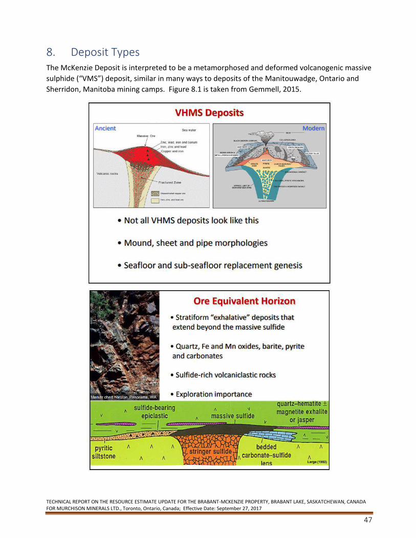
TECHNICAL REPORT ON THE RESOURCE ESTIMATE UPDATE FOR THE BRABANT-MCKENZIE PROPERTY, BRABANT LAKE, SASKATCHEWAN, CANADA FOR MURCHISON MINERALS LTD., Toronto, Ontario, Canada; Effective Date: September 27, 2017
47
8. Deposit Types The McKenzie Deposit is interpreted to be a metamorphosed and deformed volcanogenic massive
sulphide (“VMS”) deposit, similar in many ways to deposits of the Manitouwadge, Ontario and
Sherridon, Manitoba mining camps. Figure 8.1 is taken from Gemmell, 2015.
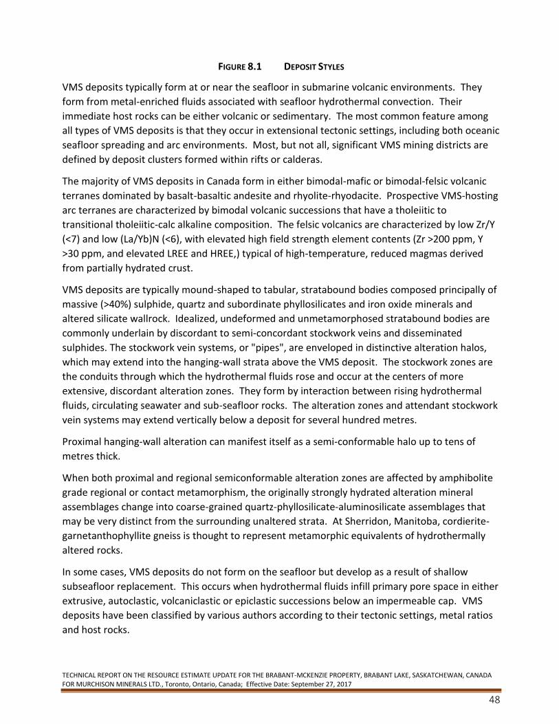
TECHNICAL REPORT ON THE RESOURCE ESTIMATE UPDATE FOR THE BRABANT-MCKENZIE PROPERTY, BRABANT LAKE, SASKATCHEWAN, CANADA FOR MURCHISON MINERALS LTD., Toronto, Ontario, Canada; Effective Date: September 27, 2017
48
FIGURE 8.1 DEPOSIT STYLES
VMS deposits typically form at or near the seafloor in submarine volcanic environments. They
form from metal-enriched fluids associated with seafloor hydrothermal convection. Their
immediate host rocks can be either volcanic or sedimentary. The most common feature among
all types of VMS deposits is that they occur in extensional tectonic settings, including both oceanic
seafloor spreading and arc environments. Most, but not all, significant VMS mining districts are
defined by deposit clusters formed within rifts or calderas.
The majority of VMS deposits in Canada form in either bimodal-mafic or bimodal-felsic volcanic
terranes dominated by basalt-basaltic andesite and rhyolite-rhyodacite. Prospective VMS-hosting
arc terranes are characterized by bimodal volcanic successions that have a tholeiitic to
transitional tholeiitic-calc alkaline composition. The felsic volcanics are characterized by low Zr/Y
(<7) and low (La/Yb)N (<6), with elevated high field strength element contents (Zr >200 ppm, Y
>30 ppm, and elevated LREE and HREE,) typical of high-temperature, reduced magmas derived
from partially hydrated crust.
VMS deposits are typically mound-shaped to tabular, stratabound bodies composed principally of
massive (>40%) sulphide, quartz and subordinate phyllosilicates and iron oxide minerals and
altered silicate wallrock. Idealized, undeformed and unmetamorphosed stratabound bodies are
commonly underlain by discordant to semi-concordant stockwork veins and disseminated
sulphides. The stockwork vein systems, or "pipes", are enveloped in distinctive alteration halos,
which may extend into the hanging-wall strata above the VMS deposit. The stockwork zones are
the conduits through which the hydrothermal fluids rose and occur at the centers of more
extensive, discordant alteration zones. They form by interaction between rising hydrothermal
fluids, circulating seawater and sub-seafloor rocks. The alteration zones and attendant stockwork
vein systems may extend vertically below a deposit for several hundred metres.
Proximal hanging-wall alteration can manifest itself as a semi-conformable halo up to tens of
metres thick.
When both proximal and regional semiconformable alteration zones are affected by amphibolite
grade regional or contact metamorphism, the originally strongly hydrated alteration mineral
assemblages change into coarse-grained quartz-phyllosilicate-aluminosilicate assemblages that
may be very distinct from the surrounding unaltered strata. At Sherridon, Manitoba, cordierite-
garnetanthophyllite gneiss is thought to represent metamorphic equivalents of hydrothermally
altered rocks.
In some cases, VMS deposits do not form on the seafloor but develop as a result of shallow
subseafloor replacement. This occurs when hydrothermal fluids infill primary pore space in either
extrusive, autoclastic, volcaniclastic or epiclastic successions below an impermeable cap. VMS
deposits have been classified by various authors according to their tectonic settings, metal ratios
and host rocks.
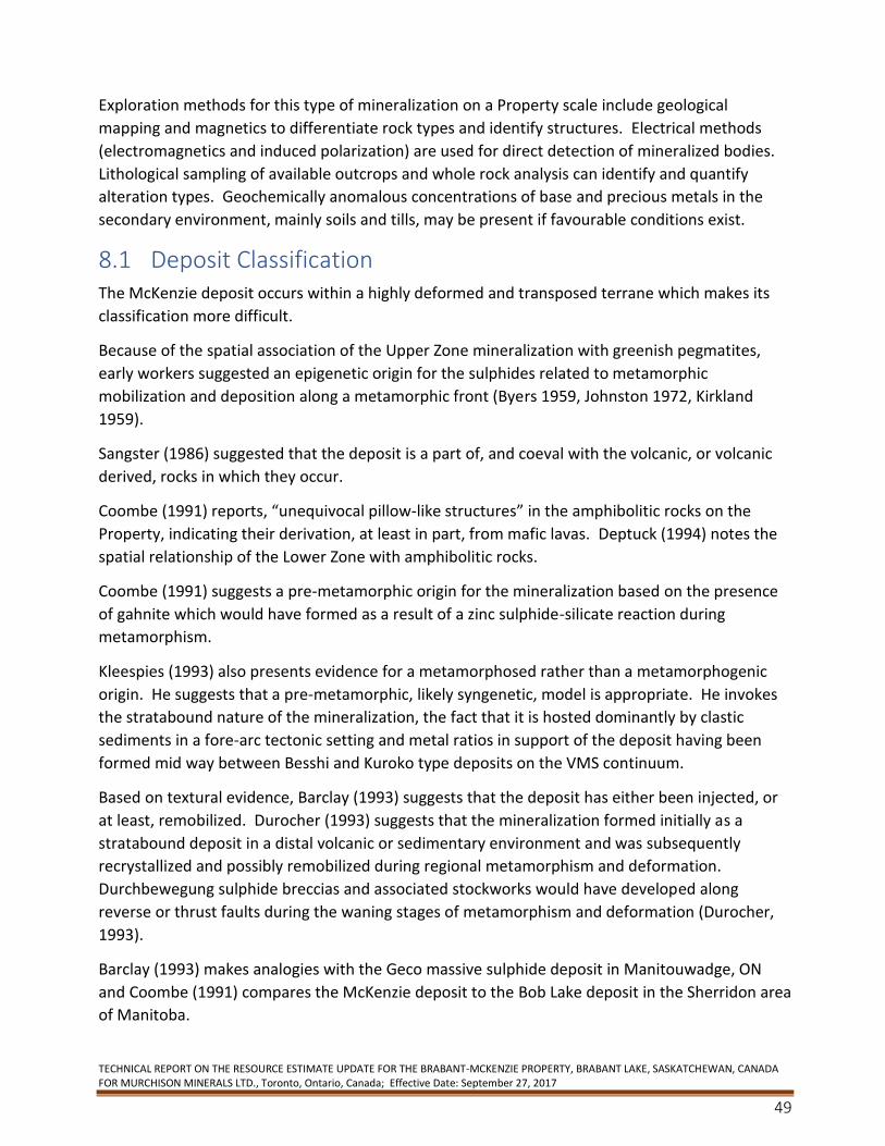
TECHNICAL REPORT ON THE RESOURCE ESTIMATE UPDATE FOR THE BRABANT-MCKENZIE PROPERTY, BRABANT LAKE, SASKATCHEWAN, CANADA FOR MURCHISON MINERALS LTD., Toronto, Ontario, Canada; Effective Date: September 27, 2017
49
Exploration methods for this type of mineralization on a Property scale include geological
mapping and magnetics to differentiate rock types and identify structures. Electrical methods
(electromagnetics and induced polarization) are used for direct detection of mineralized bodies.
Lithological sampling of available outcrops and whole rock analysis can identify and quantify
alteration types. Geochemically anomalous concentrations of base and precious metals in the
secondary environment, mainly soils and tills, may be present if favourable conditions exist.
8.1 Deposit Classification The McKenzie deposit occurs within a highly deformed and transposed terrane which makes its
classification more difficult.
Because of the spatial association of the Upper Zone mineralization with greenish pegmatites,
early workers suggested an epigenetic origin for the sulphides related to metamorphic
mobilization and deposition along a metamorphic front (Byers 1959, Johnston 1972, Kirkland
1959).
Sangster (1986) suggested that the deposit is a part of, and coeval with the volcanic, or volcanic
derived, rocks in which they occur.
Coombe (1991) reports, “unequivocal pillow-like structures” in the amphibolitic rocks on the
Property, indicating their derivation, at least in part, from mafic lavas. Deptuck (1994) notes the
spatial relationship of the Lower Zone with amphibolitic rocks.
Coombe (1991) suggests a pre-metamorphic origin for the mineralization based on the presence
of gahnite which would have formed as a result of a zinc sulphide-silicate reaction during
metamorphism.
Kleespies (1993) also presents evidence for a metamorphosed rather than a metamorphogenic
origin. He suggests that a pre-metamorphic, likely syngenetic, model is appropriate. He invokes
the stratabound nature of the mineralization, the fact that it is hosted dominantly by clastic
sediments in a fore-arc tectonic setting and metal ratios in support of the deposit having been
formed mid way between Besshi and Kuroko type deposits on the VMS continuum.
Based on textural evidence, Barclay (1993) suggests that the deposit has either been injected, or
at least, remobilized. Durocher (1993) suggests that the mineralization formed initially as a
stratabound deposit in a distal volcanic or sedimentary environment and was subsequently
recrystallized and possibly remobilized during regional metamorphism and deformation.
Durchbewegung sulphide breccias and associated stockworks would have developed along
reverse or thrust faults during the waning stages of metamorphism and deformation (Durocher,
1993).
Barclay (1993) makes analogies with the Geco massive sulphide deposit in Manitouwadge, ON
and Coombe (1991) compares the McKenzie deposit to the Bob Lake deposit in the Sherridon area
of Manitoba.
TECHNICAL REPORT ON THE RESOURCE ESTIMATE UPDATE FOR THE BRABANT-MCKENZIE PROPERTY, BRABANT LAKE, SASKATCHEWAN, CANADA FOR MURCHISON MINERALS LTD., Toronto, Ontario, Canada; Effective Date: September 27, 2017
50
FBC suggests that Brabant more closely resembles the “satellite” deposits in the Manitouwadge
(Geco) camp. The lack of a clearly defined footwall and the higher zinc to copper ratios more
closely resemble the much smaller Willroy, WillEcho and Nama Creek (7-10 million tons) deposits
found proximal to the 54 million ton Geco Deposit.
Based on photo in Figure 8.2 Gemmell suggests that the deposit is, “ more clearly subseafloor
replacement. The class all have wispy edges and the appearance of jigsaw fit”.
FIGURE 8.2 SHOWING MINERAL TEXTURE
Given the spatial relationship of the Upper Zone with greenish pegmatites (however it should be
noted that green pegmatites also occur at Geco) and the predominantly sedimentary
environment in which the Property occurs, the possibility exists that the mineralization might be
similar in origin to Broken Hill (Stanton, 1972).
8.2 Mineralization
The following description of the mineralization is presented as it relates to both historical and a
current inferred resource for the McKenzie deposit located on the Brabant Property.
The mineralization has been traced by drilling over a strike length of about 1,000 m. The width of
the zones is variable and ranges up to 18 m. The mineralization generally strikes north-north-
easterly and dips moderately west-northwesterly.
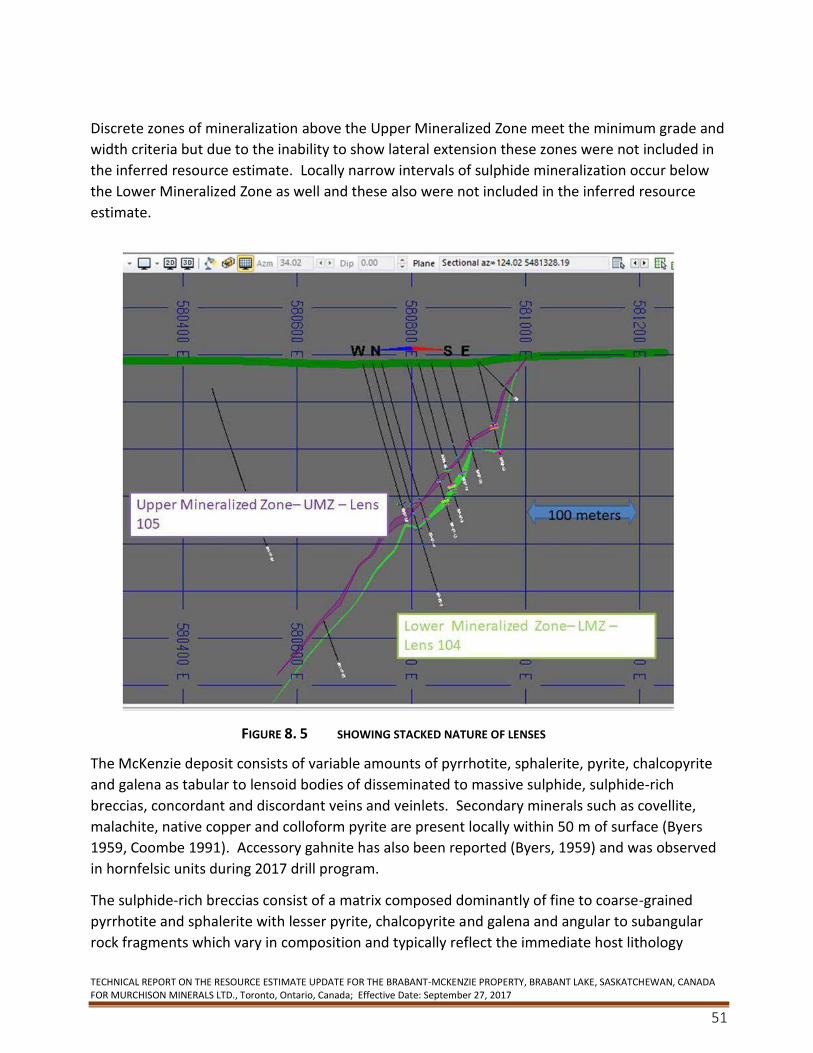
TECHNICAL REPORT ON THE RESOURCE ESTIMATE UPDATE FOR THE BRABANT-MCKENZIE PROPERTY, BRABANT LAKE, SASKATCHEWAN, CANADA FOR MURCHISON MINERALS LTD., Toronto, Ontario, Canada; Effective Date: September 27, 2017
51
Discrete zones of mineralization above the Upper Mineralized Zone meet the minimum grade and
width criteria but due to the inability to show lateral extension these zones were not included in
the inferred resource estimate. Locally narrow intervals of sulphide mineralization occur below
the Lower Mineralized Zone as well and these also were not included in the inferred resource
estimate.
FIGURE 8. 5 SHOWING STACKED NATURE OF LENSES
The McKenzie deposit consists of variable amounts of pyrrhotite, sphalerite, pyrite, chalcopyrite
and galena as tabular to lensoid bodies of disseminated to massive sulphide, sulphide-rich
breccias, concordant and discordant veins and veinlets. Secondary minerals such as covellite,
malachite, native copper and colloform pyrite are present locally within 50 m of surface (Byers
1959, Coombe 1991). Accessory gahnite has also been reported (Byers, 1959) and was observed
in hornfelsic units during 2017 drill program.
The sulphide-rich breccias consist of a matrix composed dominantly of fine to coarse-grained
pyrrhotite and sphalerite with lesser pyrite, chalcopyrite and galena and angular to subangular
rock fragments which vary in composition and typically reflect the immediate host lithology
TECHNICAL REPORT ON THE RESOURCE ESTIMATE UPDATE FOR THE BRABANT-MCKENZIE PROPERTY, BRABANT LAKE, SASKATCHEWAN, CANADA FOR MURCHISON MINERALS LTD., Toronto, Ontario, Canada; Effective Date: September 27, 2017
52
(Deptuck, 1994). Durocher (1992, 1993a,b) refers to this style of mineralization as
durchbewegung. Deptuck (1994) indicates that the highest-grade mineralization occurs as
sulphide-rich breccias with lower grades reflecting vein and disseminated sulphides. The author
of this report and feel that the sulphide mineralization is related to subseafloor replacement.
At or near the surface, the Upper and Lower Zones are found within a sequence comprised mainly
of biotite and/or felsic gneisses. In the hangingwall there are several fairly large and continuous
lenses of amphibolitic rocks which are localized along definite stratigraphic levels. There are also
several smaller and more discontinuous lenses of garnetiferous biotite gneiss and biotite-
amphibole gneiss (Durocher, 1993b).
Garnetiferous biotite gneisses/migmatites appear to be more abundant in the footwall than in the
hangingwall. Sill-like pegmatitic bodies are present at several stratigraphic levels in the footwall
and the hangingwall. Durocher (1993b) indicates that the sulphide mineralization is hosted
mainly within highly fractured and sheared pegmatite sill-like bodies. Deptuck (1994) suggests,
however, that the Lower Zone is generally spatially related to amphibole-bearing rocks. It is the
author’s opinion that the mineralization may have been remobilized into pegmatites but are not
related. Instead both lenses are typical, syngenetic stratabound deposits.
Over most of the length of the Upper Zone, both the immediate hangingwall and footwall rocks
consist of biotite +/- felsic gneisses but in several areas amphibolitic rocks and garnetiferous
biotite +/- felsic gneisses are also present in the immediate structural hangingwall. In places
where the pegmatite lenses thin or pinch out, sheared biotite +/- felsic gneisses or amphibolitic
gneisses host the Upper Zone sulphide mineralization (Durocher, 1993b).
8.2.1 Upper Mineralized Zone (UMZ)
The continuity of the Upper Zone mineralization has been tentatively correlated over a strike
length of 1,100 m. The Upper Zone has continuity from the surface down dip for about 500 m.
The Upper Zone model used 105 diamond drill holes with an average thickness/length of 5.3 m–
no minimums were applied at this stage–geological boundaries were used with an average grade
of 4.6% Zn over 5.32 m and a maximum downhole length of 21.4 m with an approximate true
thickness of 16 metres.
8.2.2 Lower Mineralized Zone (LMZ)
The Lower Zone is located 25-30 m below the Upper Zone. Only 57 Lower Zone intersections
meet the criteria for inclusion in the inferred resource estimate because most of the holes from
the early drill campaigns did not go deep enough to intersect the Lower Zone. It has a strike
length of 400 m and appears to have down-dip continuity of about 520 m. There is a suggestion
that the Lower Zone’s dip flattens with depth. Fifty-seven holes were used with an average
thickness/length of 6.7 metres – no minimums were applied at this stage– geological boundaries
were used with an average length-weighted grade of 6.2 % Zn and maximum down hole length of
29.5 m and approximate true thickness of 18 m.
TECHNICAL REPORT ON THE RESOURCE ESTIMATE UPDATE FOR THE BRABANT-MCKENZIE PROPERTY, BRABANT LAKE, SASKATCHEWAN, CANADA FOR MURCHISON MINERALS LTD., Toronto, Ontario, Canada; Effective Date: September 27, 2017
53
8.3 Structure
The dominant structural features recorded in the drill logs are foliation, banding and gneissosity,
plus local instances of small isoclinal folds in the core and variations in dip. Most drill logs record
evidence of increased deformation such as where foliations are variable, irregular and/or stronger
as well as the existence of chloritic slips or partings (Stewart and Chamois, 1994). Durocher
(1993b) interpreted low angled reverse or thrust faults based on graphitic and/or chloritic
mylonite intervals, slips, partings, shears or fault gouge that dip generally subparallel to the
foliation and banding. Some faults have been interpreted based on evidence seen in sections, but
the correlation of these structures is difficult because of the lack of detail in the older logs
(Deptuck, 1994).
There is debate whether the durchbewegung textures are in fact subseafloor replacement as the
clasts all have wispy edges and the appearance of jigsaw fit. This has an important impact on the
possible genesis of the deposit.
8.4 Alteration
Durocher (1992) suggested that the presence of sillimanite and/or cordierite may be indicative of
pre-metamorphic hydrothermal alteration Abbas-Hasanie et al. (1992), however, documented
that sillimanite and cordierite are common throughout the MLB and Kisseynew Domain.
It should be noted that hornfels type alteration – typically cordierite, chlorite, sillimanite and
garnet in typical felted masses increased in proximity and adjacent to mineralization strongly
suggesting ore related hydrothermal alteration. Grain size also typically increased again
suggesting pre-metamorphic alteration.
Chlorite with carbonate +/- pyrite commonly coats late fractures oriented at a high angle to the
foliation. However, chlorite-rich zones are generally quite removed from the mineralized zones
and are unlikely to express hydrothermal alteration related to the mineralization. More
significant possibly is the common occurrence of pervasive green colourations in pegmatites and
other lithologies proximal to the mineralized zones. This greenish colour is caused by epidote +/-
sericite alteration of plagioclase. This colouration is different from the chlorite occurrences noted
above and these pervasive green zones are more silicified and more massive than adjacent rocks
(Stewart and Chamois, 1994).
Coombe (1991) notes an increase in garnet in the footwall rocks and suggests that this might be
related to footwall alteration.
9. Exploration In October of 2015, 2 field investigations were carried out to the Property to confirm
known drill collars, grid locations, access routes and showings for quality control purposes,

TECHNICAL REPORT ON THE RESOURCE ESTIMATE UPDATE FOR THE BRABANT-MCKENZIE PROPERTY, BRABANT LAKE, SASKATCHEWAN, CANADA FOR MURCHISON MINERALS LTD., Toronto, Ontario, Canada; Effective Date: September 27, 2017
54
geo-rectifying existing data and planning for future exploration programs and reviewing
remaining and accessible core;
Over the periods September – December 2016, February 2017 and August 2017 the
programs included prospecting, investigation of mineralized showings and
identification of geophysical targets, an airborne Heli Sub Audio Magnetics geophysical
survey (“HeliSAM”) and follow up ground SQUID electromagnetic (“EM”) and
magnetics (“Mag”) geophysical surveys covering prospective geological horizons.
In October 2016 the Company also conducted a prospecting program on three minfile
showings, the Teneke (Ryan Gossan), Min and Shore showings and one geophysics
target (TOM3) identified from the 2011 Manicouagan VTEM airborne geophysical
survey.
Rock samples were taken during the prospecting program from the Teneke (Ryan
Gossan) and TOM3 showings. Results from the Teneke yielded an elevated zinc
showing of 1,555 ppm, however, values in copper, silver, lead and gold were generally
low and results from the TOM3 sample did not yield any significant values.
A HeliSAM Geophysics Survey was carried out between November 23 and December 9,
2016 by Discovery Geophysics International (Discovery) in conjunction with Gap
Geophysics Australia Pty Limited (GAP) to conduct the geophysical survey using GAP’s
proprietary techniques.
The survey grid covered 122-line kilometres using 50-meter line spacing over the main
Deposit and adjacent mineral claims.
In February 2017, SQUID (a Time Domain Electromagnetic and Magnetometer
geophysical survey) using a Jessy-Deep HT SQUID sensor was carried out on 5 lines
totaling 12.45 km. The survey was designed to follow up newly identified HeliSam
geophysical anomalies located on mineral claims.
In August 2017, a 4-person crew conducted field investigations on identified outcrop
showings and previously defined SQUID and VTEM geophysical targets in order to
identify potential mineralization.
Five different target areas on the property were prospected and sampled.
Prospecting and sampling in the vicinity of an interpreted 1.3 km long surface
projection of a geophysical target area was also carried out and rock samples and soil
samples were collected to the west of the prospective outcrops.
Prospecting and rock and soil sampling was also carried out on the TOM2 and Priority 3 geophysical targets and the Ryan Gossan.
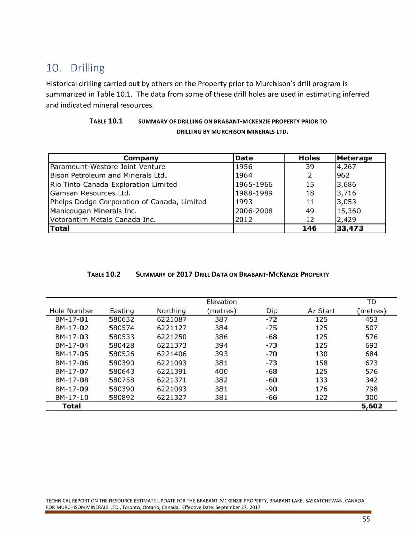
TECHNICAL REPORT ON THE RESOURCE ESTIMATE UPDATE FOR THE BRABANT-MCKENZIE PROPERTY, BRABANT LAKE, SASKATCHEWAN, CANADA FOR MURCHISON MINERALS LTD., Toronto, Ontario, Canada; Effective Date: September 27, 2017
55
10. Drilling Historical drilling carried out by others on the Property prior to Murchison’s drill program is
summarized in Table 10.1. The data from some of these drill holes are used in estimating inferred
and indicated mineral resources.
TABLE 10.1 SUMMARY OF DRILLING ON BRABANT-MCKENZIE PROPERTY PRIOR TO DRILLING BY MURCHISON MINERALS LTD.
TABLE 10.2 SUMMARY OF 2017 DRILL DATA ON BRABANT-MCKENZIE PROPERTY
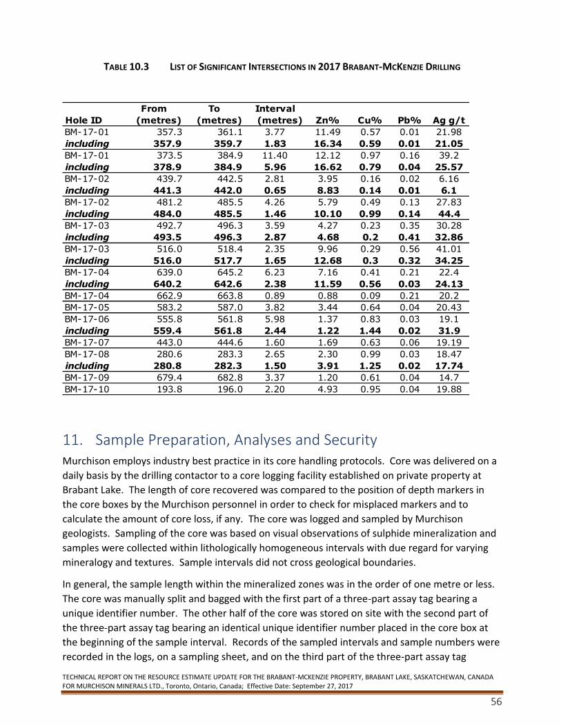
TECHNICAL REPORT ON THE RESOURCE ESTIMATE UPDATE FOR THE BRABANT-MCKENZIE PROPERTY, BRABANT LAKE, SASKATCHEWAN, CANADA FOR MURCHISON MINERALS LTD., Toronto, Ontario, Canada; Effective Date: September 27, 2017
56
TABLE 10.3 LIST OF SIGNIFICANT INTERSECTIONS IN 2017 BRABANT-MCKENZIE DRILLING
11. Sample Preparation, Analyses and Security Murchison employs industry best practice in its core handling protocols. Core was delivered on a
daily basis by the drilling contactor to a core logging facility established on private property at
Brabant Lake. The length of core recovered was compared to the position of depth markers in
the core boxes by the Murchison personnel in order to check for misplaced markers and to
calculate the amount of core loss, if any. The core was logged and sampled by Murchison
geologists. Sampling of the core was based on visual observations of sulphide mineralization and
samples were collected within lithologically homogeneous intervals with due regard for varying
mineralogy and textures. Sample intervals did not cross geological boundaries.
In general, the sample length within the mineralized zones was in the order of one metre or less.
The core was manually split and bagged with the first part of a three-part assay tag bearing a
unique identifier number. The other half of the core was stored on site with the second part of
the three-part assay tag bearing an identical unique identifier number placed in the core box at
the beginning of the sample interval. Records of the sampled intervals and sample numbers were
recorded in the logs, on a sampling sheet, and on the third part of the three-part assay tag
From To Interval
Hole ID (metres) (metres) (metres) Zn% Cu% Pb% Ag g/t
BM-17-01 357.3 361.1 3.77 11.49 0.57 0.01 21.98
including 357.9 359.7 1.83 16.34 0.59 0.01 21.05
BM-17-01 373.5 384.9 11.40 12.12 0.97 0.16 39.2
including 378.9 384.9 5.96 16.62 0.79 0.04 25.57
BM-17-02 439.7 442.5 2.81 3.95 0.16 0.02 6.16
including 441.3 442.0 0.65 8.83 0.14 0.01 6.1
BM-17-02 481.2 485.5 4.26 5.79 0.49 0.13 27.83
including 484.0 485.5 1.46 10.10 0.99 0.14 44.4
BM-17-03 492.7 496.3 3.59 4.27 0.23 0.35 30.28
including 493.5 496.3 2.87 4.68 0.2 0.41 32.86
BM-17-03 516.0 518.4 2.35 9.96 0.29 0.56 41.01
including 516.0 517.7 1.65 12.68 0.3 0.32 34.25
BM-17-04 639.0 645.2 6.23 7.16 0.41 0.21 22.4
including 640.2 642.6 2.38 11.59 0.56 0.03 24.13
BM-17-04 662.9 663.8 0.89 0.88 0.09 0.21 20.2
BM-17-05 583.2 587.0 3.82 3.44 0.64 0.04 20.43
BM-17-06 555.8 561.8 5.98 1.37 0.83 0.03 19.1
including 559.4 561.8 2.44 1.22 1.44 0.02 31.9
BM-17-07 443.0 444.6 1.60 1.69 0.63 0.06 19.19
BM-17-08 280.6 283.3 2.65 2.30 0.99 0.03 18.47
including 280.8 282.3 1.50 3.91 1.25 0.02 17.74
BM-17-09 679.4 682.8 3.37 1.20 0.61 0.04 14.7
BM-17-10 193.8 196.0 2.20 4.93 0.95 0.04 19.88
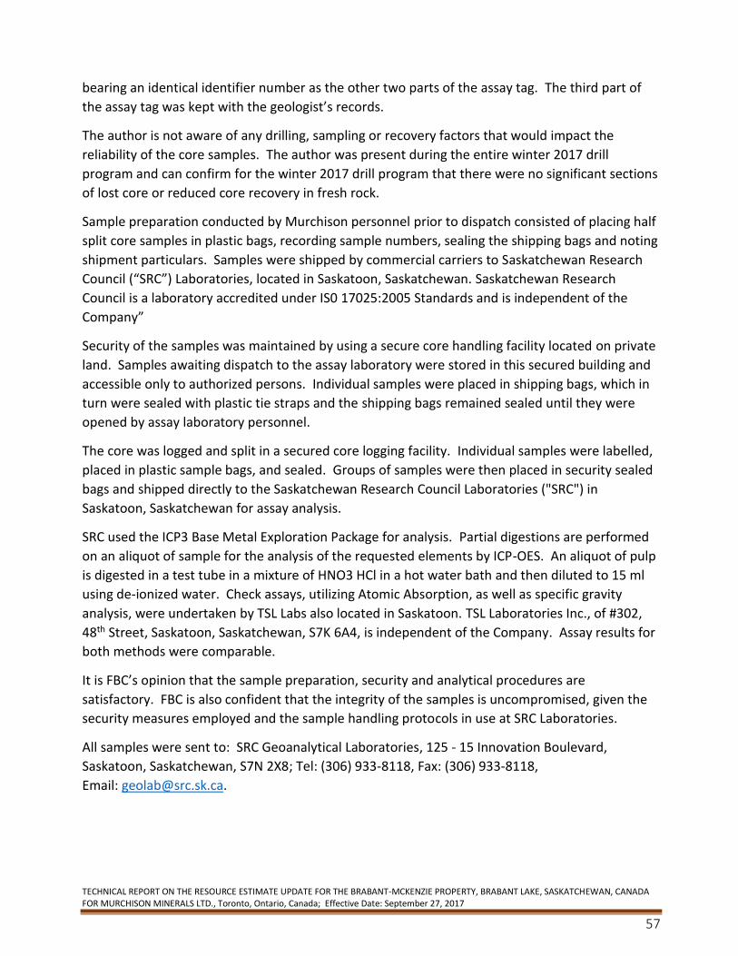
TECHNICAL REPORT ON THE RESOURCE ESTIMATE UPDATE FOR THE BRABANT-MCKENZIE PROPERTY, BRABANT LAKE, SASKATCHEWAN, CANADA FOR MURCHISON MINERALS LTD., Toronto, Ontario, Canada; Effective Date: September 27, 2017
57
bearing an identical identifier number as the other two parts of the assay tag. The third part of
the assay tag was kept with the geologist’s records.
The author is not aware of any drilling, sampling or recovery factors that would impact the
reliability of the core samples. The author was present during the entire winter 2017 drill
program and can confirm for the winter 2017 drill program that there were no significant sections
of lost core or reduced core recovery in fresh rock.
Sample preparation conducted by Murchison personnel prior to dispatch consisted of placing half
split core samples in plastic bags, recording sample numbers, sealing the shipping bags and noting
shipment particulars. Samples were shipped by commercial carriers to Saskatchewan Research
Council (“SRC”) Laboratories, located in Saskatoon, Saskatchewan. Saskatchewan Research
Council is a laboratory accredited under IS0 17025:2005 Standards and is independent of the
Company”
Security of the samples was maintained by using a secure core handling facility located on private
land. Samples awaiting dispatch to the assay laboratory were stored in this secured building and
accessible only to authorized persons. Individual samples were placed in shipping bags, which in
turn were sealed with plastic tie straps and the shipping bags remained sealed until they were
opened by assay laboratory personnel.
The core was logged and split in a secured core logging facility. Individual samples were labelled,
placed in plastic sample bags, and sealed. Groups of samples were then placed in security sealed
bags and shipped directly to the Saskatchewan Research Council Laboratories ("SRC") in
Saskatoon, Saskatchewan for assay analysis.
SRC used the ICP3 Base Metal Exploration Package for analysis. Partial digestions are performed
on an aliquot of sample for the analysis of the requested elements by ICP-OES. An aliquot of pulp
is digested in a test tube in a mixture of HNO3 HCl in a hot water bath and then diluted to 15 ml
using de-ionized water. Check assays, utilizing Atomic Absorption, as well as specific gravity
analysis, were undertaken by TSL Labs also located in Saskatoon. TSL Laboratories Inc., of #302,
48th Street, Saskatoon, Saskatchewan, S7K 6A4, is independent of the Company. Assay results for
both methods were comparable.
It is FBC’s opinion that the sample preparation, security and analytical procedures are
satisfactory. FBC is also confident that the integrity of the samples is uncompromised, given the
security measures employed and the sample handling protocols in use at SRC Laboratories.
All samples were sent to: SRC Geoanalytical Laboratories, 125 - 15 Innovation Boulevard,
Saskatoon, Saskatchewan, S7N 2X8; Tel: (306) 933-8118, Fax: (306) 933-8118,
Email: [email protected].

TECHNICAL REPORT ON THE RESOURCE ESTIMATE UPDATE FOR THE BRABANT-MCKENZIE PROPERTY, BRABANT LAKE, SASKATCHEWAN, CANADA FOR MURCHISON MINERALS LTD., Toronto, Ontario, Canada; Effective Date: September 27, 2017
58
12. Data Verification Standards were obtained from Canadian Research Laboratories. These were inserted as part of
the sampling protocol. Both high and low grade standards were used. In addition, pulps were
submitted to a second laboratory.
The duplicate and check assays were sent to: TSL Laboratories Inc., 2 - 302 48th Street,
Saskatoon, Saskatchewan, S7K 6A4; Tel: (306) 931-1033, Fax (306) 242-4717,
Email: [email protected]. Results are given below.
FIGURE 12.1 LAB COMPARISONS OF SILVER ASSAYS
SRC Labs tends to report higher silver values than TSL. This also appears to be the case when SRC
is compared to submitted standards.
-
10.00
20.00
30.00
40.00
50.00
1 2 3 4 5 6 7 8 9 10 11 12 13 14 15 16
gm S
ilve
r
Silver
SRC Labs TSL Labs
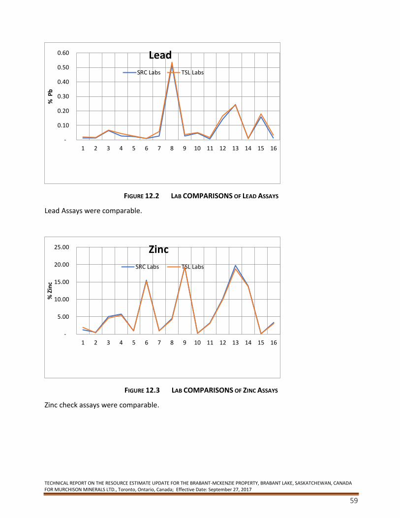
TECHNICAL REPORT ON THE RESOURCE ESTIMATE UPDATE FOR THE BRABANT-MCKENZIE PROPERTY, BRABANT LAKE, SASKATCHEWAN, CANADA FOR MURCHISON MINERALS LTD., Toronto, Ontario, Canada; Effective Date: September 27, 2017
59
FIGURE 12.2 LAB COMPARISONS OF LEAD ASSAYS
Lead Assays were comparable.
FIGURE 12.3 LAB COMPARISONS OF ZINC ASSAYS
Zinc check assays were comparable.
-
0.10
0.20
0.30
0.40
0.50
0.60
1 2 3 4 5 6 7 8 9 10 11 12 13 14 15 16
% P
bLead
SRC Labs TSL Labs
-
5.00
10.00
15.00
20.00
25.00
1 2 3 4 5 6 7 8 9 10 11 12 13 14 15 16
% Z
inc
Zinc
SRC Labs TSL Labs
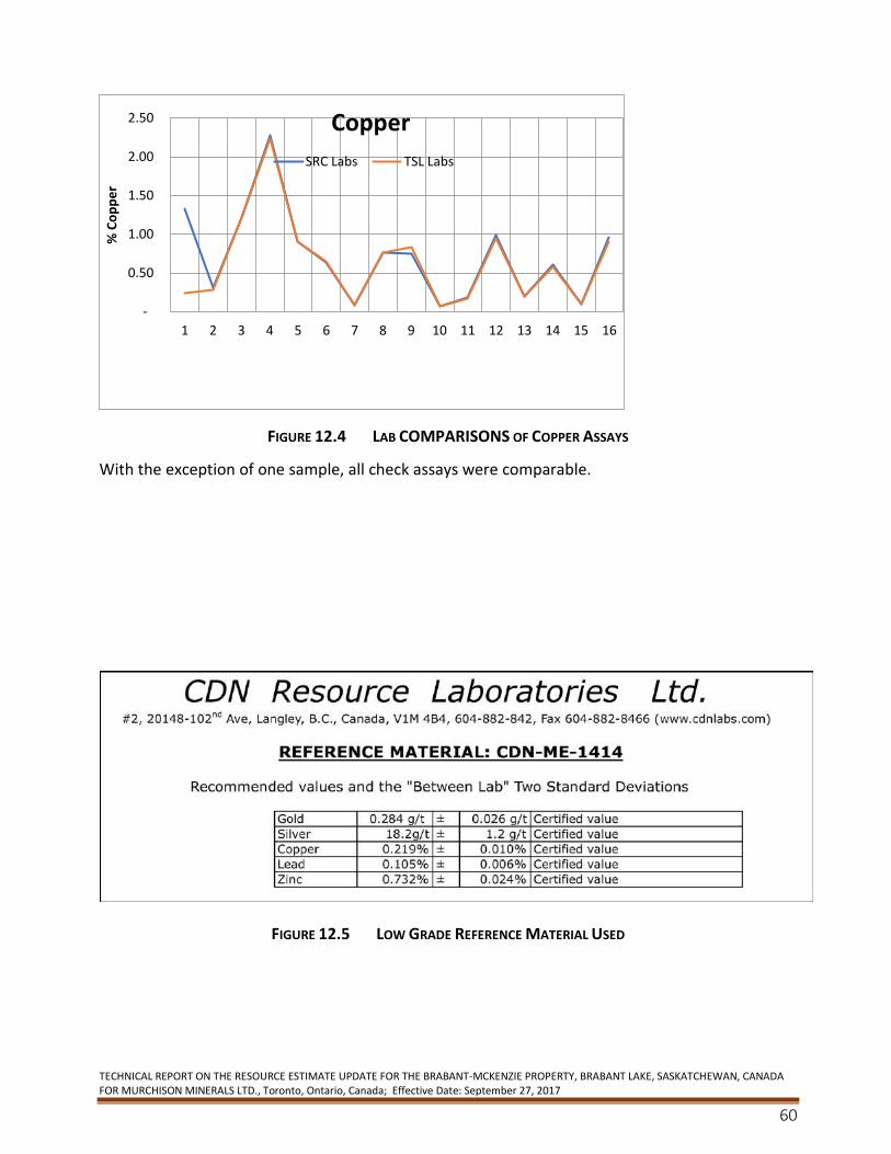
TECHNICAL REPORT ON THE RESOURCE ESTIMATE UPDATE FOR THE BRABANT-MCKENZIE PROPERTY, BRABANT LAKE, SASKATCHEWAN, CANADA FOR MURCHISON MINERALS LTD., Toronto, Ontario, Canada; Effective Date: September 27, 2017
60
FIGURE 12.4 LAB COMPARISONS OF COPPER ASSAYS
With the exception of one sample, all check assays were comparable.
FIGURE 12.5 LOW GRADE REFERENCE MATERIAL USED
-
0.50
1.00
1.50
2.00
2.50
1 2 3 4 5 6 7 8 9 10 11 12 13 14 15 16
% C
op
pe
rCopper
SRC Labs TSL Labs
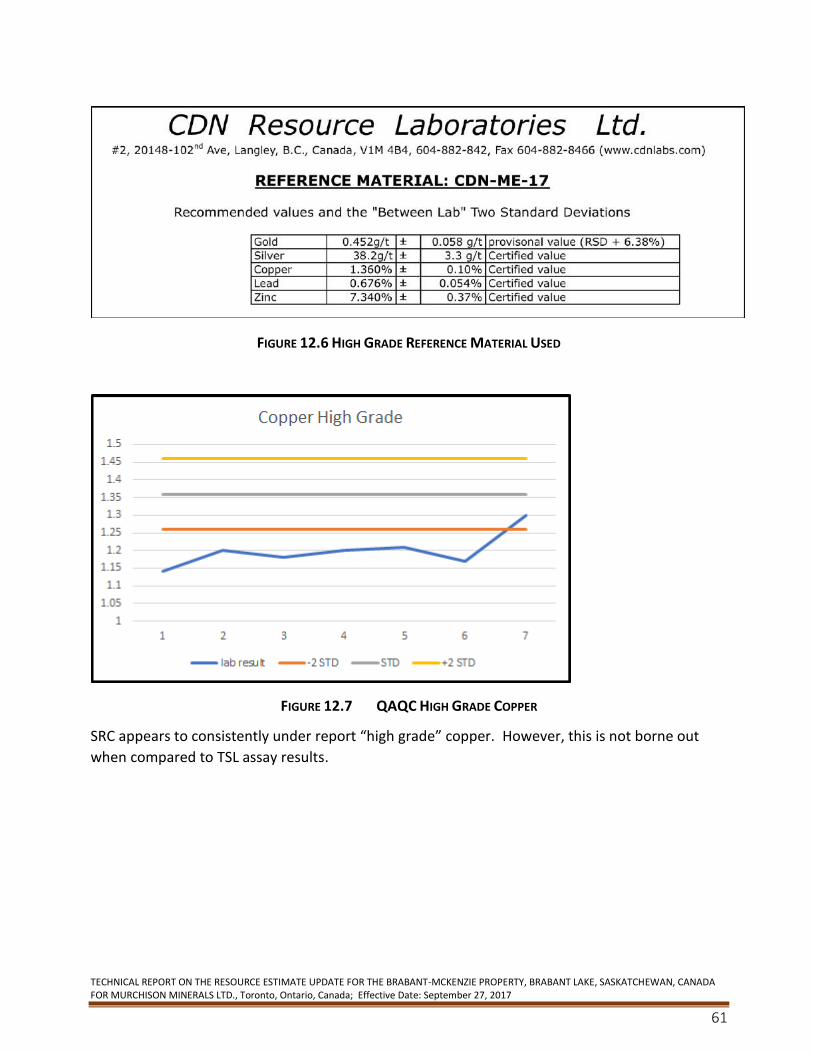
TECHNICAL REPORT ON THE RESOURCE ESTIMATE UPDATE FOR THE BRABANT-MCKENZIE PROPERTY, BRABANT LAKE, SASKATCHEWAN, CANADA FOR MURCHISON MINERALS LTD., Toronto, Ontario, Canada; Effective Date: September 27, 2017
61
FIGURE 12.6 HIGH GRADE REFERENCE MATERIAL USED
FIGURE 12.7 QAQC HIGH GRADE COPPER
SRC appears to consistently under report “high grade” copper. However, this is not borne out
when compared to TSL assay results.
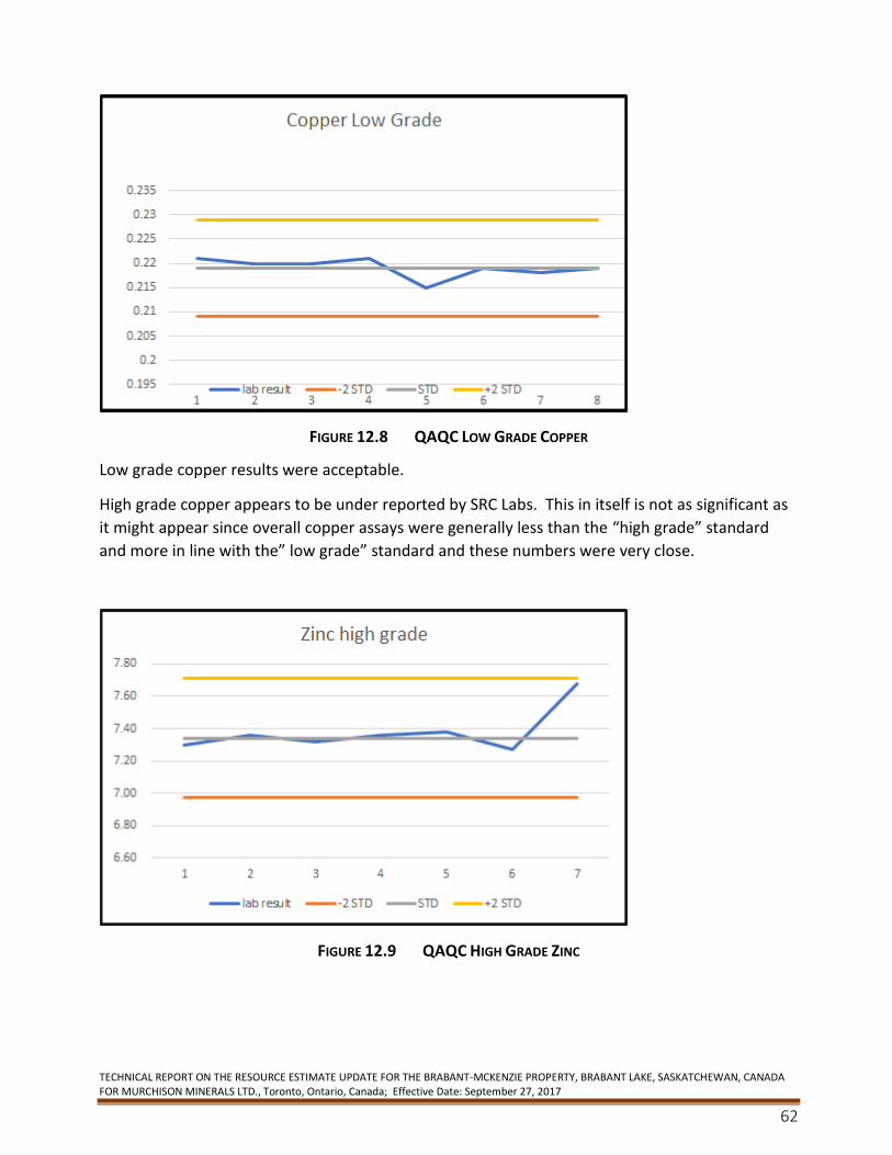
TECHNICAL REPORT ON THE RESOURCE ESTIMATE UPDATE FOR THE BRABANT-MCKENZIE PROPERTY, BRABANT LAKE, SASKATCHEWAN, CANADA FOR MURCHISON MINERALS LTD., Toronto, Ontario, Canada; Effective Date: September 27, 2017
62
FIGURE 12.8 QAQC LOW GRADE COPPER
Low grade copper results were acceptable.
High grade copper appears to be under reported by SRC Labs. This in itself is not as significant as
it might appear since overall copper assays were generally less than the “high grade” standard
and more in line with the” low grade” standard and these numbers were very close.
FIGURE 12.9 QAQC HIGH GRADE ZINC
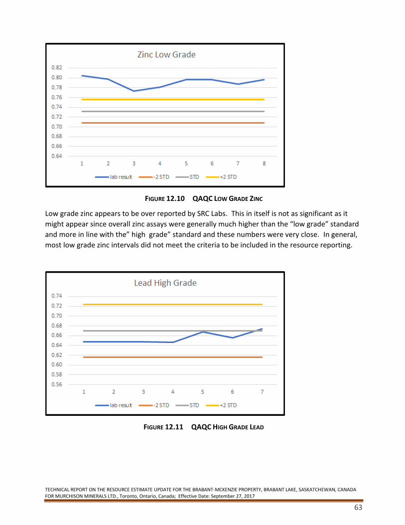
TECHNICAL REPORT ON THE RESOURCE ESTIMATE UPDATE FOR THE BRABANT-MCKENZIE PROPERTY, BRABANT LAKE, SASKATCHEWAN, CANADA FOR MURCHISON MINERALS LTD., Toronto, Ontario, Canada; Effective Date: September 27, 2017
63
FIGURE 12.10 QAQC LOW GRADE ZINC
Low grade zinc appears to be over reported by SRC Labs. This in itself is not as significant as it
might appear since overall zinc assays were generally much higher than the “low grade” standard
and more in line with the” high grade” standard and these numbers were very close. In general,
most low grade zinc intervals did not meet the criteria to be included in the resource reporting.
FIGURE 12.11 QAQC HIGH GRADE LEAD
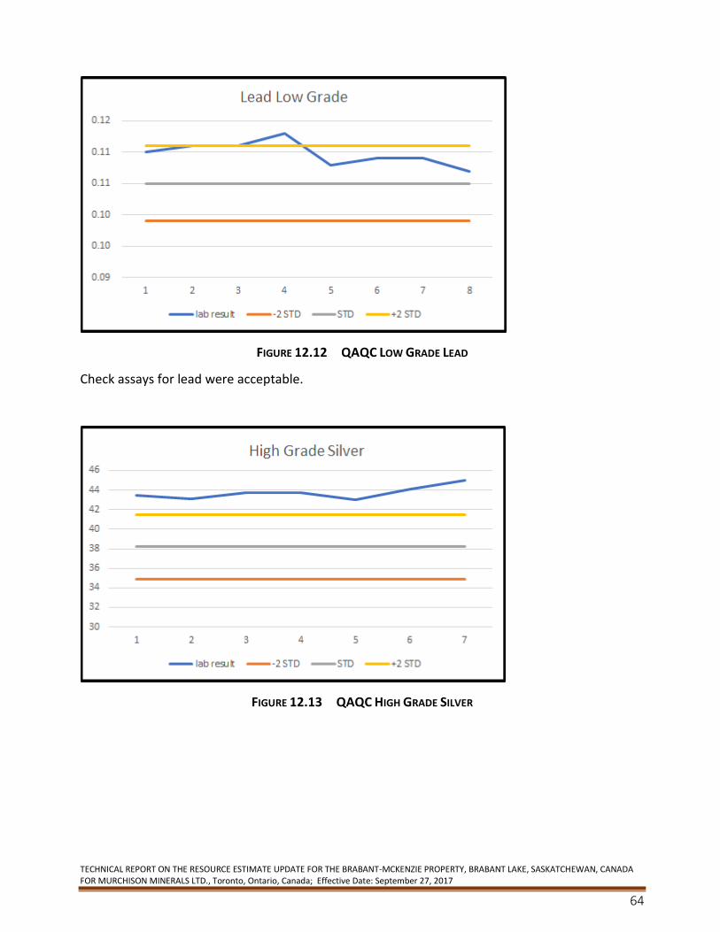
TECHNICAL REPORT ON THE RESOURCE ESTIMATE UPDATE FOR THE BRABANT-MCKENZIE PROPERTY, BRABANT LAKE, SASKATCHEWAN, CANADA FOR MURCHISON MINERALS LTD., Toronto, Ontario, Canada; Effective Date: September 27, 2017
64
FIGURE 12.12 QAQC LOW GRADE LEAD
Check assays for lead were acceptable.
FIGURE 12.13 QAQC HIGH GRADE SILVER
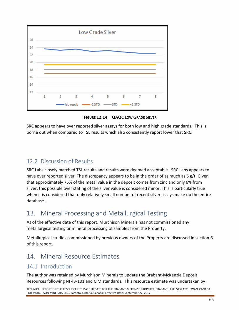
TECHNICAL REPORT ON THE RESOURCE ESTIMATE UPDATE FOR THE BRABANT-MCKENZIE PROPERTY, BRABANT LAKE, SASKATCHEWAN, CANADA FOR MURCHISON MINERALS LTD., Toronto, Ontario, Canada; Effective Date: September 27, 2017
65
FIGURE 12.14 QAQC LOW GRADE SILVER
SRC appears to have over reported silver assays for both low and high grade standards. This is
borne out when compared to TSL results which also consistently report lower that SRC.
12.2 Discussion of Results
SRC Labs closely matched TSL results and results were deemed acceptable. SRC Labs appears to
have over reported silver. The discrepancy appears to be in the order of as much as 6 g/t. Given
that approximately 75% of the metal value in the deposit comes from zinc and only 6% from
silver, this possible over stating of the silver value is considered minor. This is particularly true
when it is considered that only relatively small number of recent silver assays make up the entire
database.
13. Mineral Processing and Metallurgical Testing As of the effective date of this report, Murchison Minerals has not commissioned any
metallurgical testing or mineral processing of samples from the Property.
Metallurgical studies commissioned by previous owners of the Property are discussed in section 6
of this report.
14. Mineral Resource Estimates
14.1 Introduction
The author was retained by Murchison Minerals to update the Brabant-McKenzie Deposit
Resources following NI 43-101 and CIM standards. This resource estimate was undertaken by
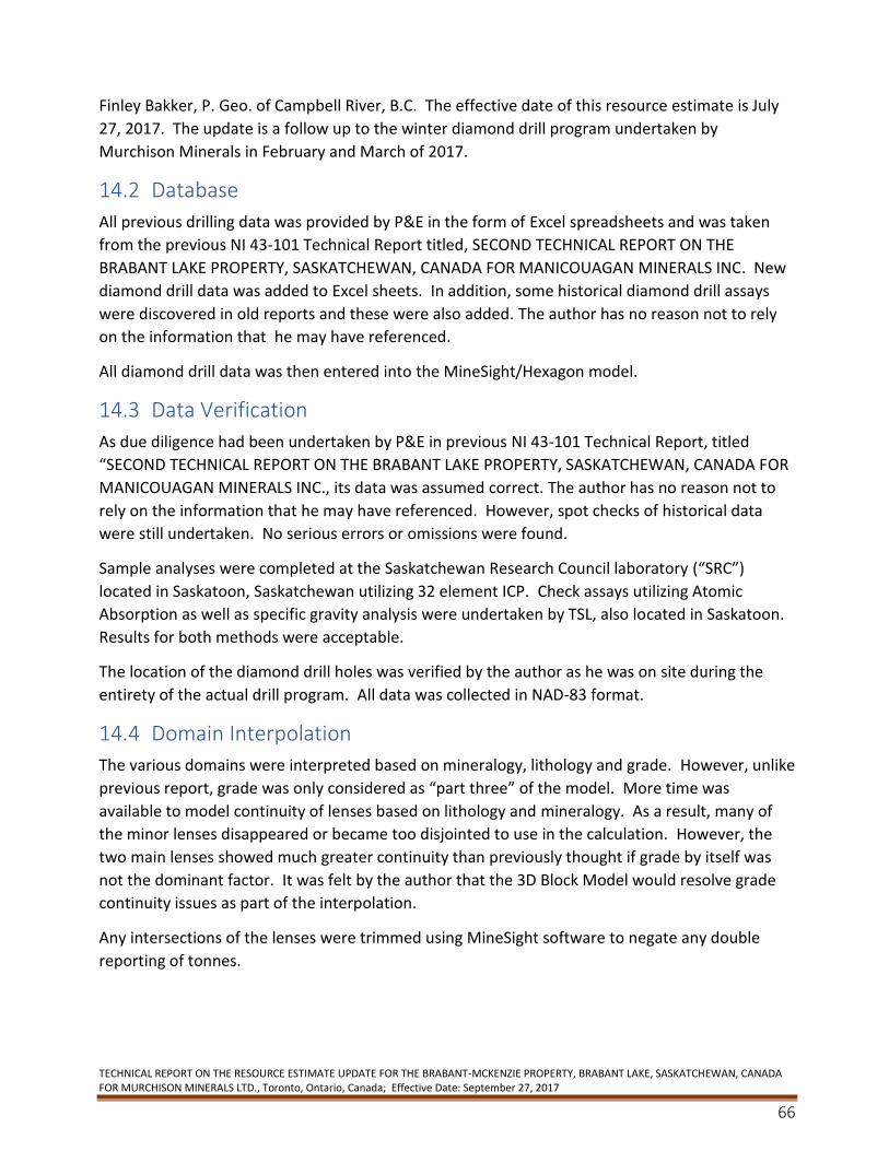
TECHNICAL REPORT ON THE RESOURCE ESTIMATE UPDATE FOR THE BRABANT-MCKENZIE PROPERTY, BRABANT LAKE, SASKATCHEWAN, CANADA FOR MURCHISON MINERALS LTD., Toronto, Ontario, Canada; Effective Date: September 27, 2017
66
Finley Bakker, P. Geo. of Campbell River, B.C. The effective date of this resource estimate is July
27, 2017. The update is a follow up to the winter diamond drill program undertaken by
Murchison Minerals in February and March of 2017.
14.2 Database
All previous drilling data was provided by P&E in the form of Excel spreadsheets and was taken
from the previous NI 43-101 Technical Report titled, SECOND TECHNICAL REPORT ON THE
BRABANT LAKE PROPERTY, SASKATCHEWAN, CANADA FOR MANICOUAGAN MINERALS INC. New
diamond drill data was added to Excel sheets. In addition, some historical diamond drill assays
were discovered in old reports and these were also added. The author has no reason not to rely
on the information that he may have referenced.
All diamond drill data was then entered into the MineSight/Hexagon model.
14.3 Data Verification
As due diligence had been undertaken by P&E in previous NI 43-101 Technical Report, titled
“SECOND TECHNICAL REPORT ON THE BRABANT LAKE PROPERTY, SASKATCHEWAN, CANADA FOR
MANICOUAGAN MINERALS INC., its data was assumed correct. The author has no reason not to
rely on the information that he may have referenced. However, spot checks of historical data
were still undertaken. No serious errors or omissions were found.
Sample analyses were completed at the Saskatchewan Research Council laboratory (“SRC”)
located in Saskatoon, Saskatchewan utilizing 32 element ICP. Check assays utilizing Atomic
Absorption as well as specific gravity analysis were undertaken by TSL, also located in Saskatoon.
Results for both methods were acceptable.
The location of the diamond drill holes was verified by the author as he was on site during the
entirety of the actual drill program. All data was collected in NAD-83 format.
14.4 Domain Interpolation
The various domains were interpreted based on mineralogy, lithology and grade. However, unlike
previous report, grade was only considered as “part three” of the model. More time was
available to model continuity of lenses based on lithology and mineralogy. As a result, many of
the minor lenses disappeared or became too disjointed to use in the calculation. However, the
two main lenses showed much greater continuity than previously thought if grade by itself was
not the dominant factor. It was felt by the author that the 3D Block Model would resolve grade
continuity issues as part of the interpolation.
Any intersections of the lenses were trimmed using MineSight software to negate any double
reporting of tonnes.
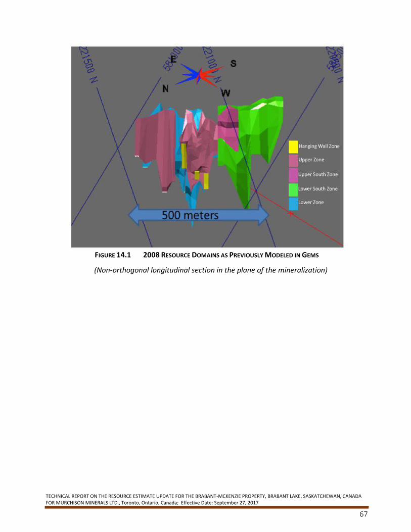
TECHNICAL REPORT ON THE RESOURCE ESTIMATE UPDATE FOR THE BRABANT-MCKENZIE PROPERTY, BRABANT LAKE, SASKATCHEWAN, CANADA FOR MURCHISON MINERALS LTD., Toronto, Ontario, Canada; Effective Date: September 27, 2017
67
FIGURE 14.1 2008 RESOURCE DOMAINS AS PREVIOUSLY MODELED IN GEMS
(Non-orthogonal longitudinal section in the plane of the mineralization)
TECHNICAL REPORT ON THE RESOURCE ESTIMATE UPDATE FOR THE BRABANT-MCKENZIE PROPERTY, BRABANT LAKE, SASKATCHEWAN, CANADA FOR MURCHISON MINERALS LTD., Toronto, Ontario, Canada; Effective Date: September 27, 2017
68
FIGURE 14.2 2017 GEOLOGICAL MODEL OF UMZ AND LMZ AS MODELED IN MINESIGHT
14.5 Lens/Rock Code
Only two lens codes were used in the actual resource calculation, although minor lenses were
also assigned codes in an attempt to create a lens solid. At this stage, it was not possible to
create coherent lenses on the smaller/minor lenses. All lens codes were manually entered into
the assay portion of the model to ensure that correct intervals were interpolated. While it is
easier to let the 3D solid intersect the lens and assign codes based on actual intercept, and is
technically more correct, since only the precise interval that intersects the solid is used, minor
deviations in the lens solid over 200+ metres could mean only a portion of the assay interval
would be flagged. Instead mineralized codes were manually entered as LENS2 and the model
then “speared” the lens and assigned LENS (not LENS2). The two were compared to ensure that
the correct interval was being used.
Lens code 104 was assigned to the Lower Lens/Zone (“Lower Mineralized Zone” or “LMZ”).
Lens code 105 was assigned to the Upper Lens/Zone (“Upper Mineralized Zone” or “UMZ”).
A calculation of the potential impact of not modeling the minor lenses was made. A simple
calculation was made assuming a 15-metre search radius around each intercept. Results were not
reported as tonnage was not considered significant at this stage.
TECHNICAL REPORT ON THE RESOURCE ESTIMATE UPDATE FOR THE BRABANT-MCKENZIE PROPERTY, BRABANT LAKE, SASKATCHEWAN, CANADA FOR MURCHISON MINERALS LTD., Toronto, Ontario, Canada; Effective Date: September 27, 2017
69
The UMZ used 105 diamond drill holes for the geological model; no minimums were applied at
this stage – geological boundaries were used - with an average grade of 4.6% Zn over 5.32 m and
a maximum downhole length of 21.4 m with an approximate true thickness of 16 m.
The LMZ that is located 25-30 m below the Upper Mineralized Zone only used fifty seven diamond
drill holes for the resource calculation. Less LMZ intersections meet the criteria for inclusion in
the resource estimate than for the UMZ because most of the holes from the early drill campaigns
did not go deep enough to intersect this zone. It has a strike length of 400 m and appears to have
down-dip continuity for about 520 m. There is a suggestion that the LMZ dip flattens with depth.
Of the 57 holes used , they have an average thickness/length of 6.7 m and an average length
weighted grade of 6.2 % Zn – no minimums were applied at this stage– geological boundaries
were used. The LMZ had a maximum down hole length of 29.5 m and approximate true thickness
of 18 m.
14.6 Composites
Three sets of composites were created for calculating purposes.
Composite 1 – composited SG/density for use in Density weighted composites and composited
one SG for each interval to be used in a separate calculation for populating the 3D block model.
Details are given in the appendices. Calculations were limited by lens code (LENS2).
Composite 2 – composited metal grades over the entire lens code. This was done to ensure that
entire interval used in calculation could be put into an Excel spreadsheet and compared to block
model. Calculations were limited by lens code (LENS2).
Composite 3 – composited metal grades were limited to lens code but assigned a maximum of
one metre. Calculations were limited by lens code (LENS2). These composites were used in the
model build.
14.7 Grade Capping
Grade-capping was not done because it was noted that the general uniformity of grade was fairly
consistent with no significant outliers in the assay results.
14.8 Variography
A series of variograms were created using Hexagon program – MSDA –this allowed a series of 3D
variograms to be created based on lens code.
These 3D variograms were imported into MineSight. It is apparent that zinc shows a strong
correlation to the trend of the lenses and the other metals do not. The gold and lead variograms
may be misleading since, in many cases, they were consistently quite low given a strong
correlation over great distance.

TECHNICAL REPORT ON THE RESOURCE ESTIMATE UPDATE FOR THE BRABANT-MCKENZIE PROPERTY, BRABANT LAKE, SASKATCHEWAN, CANADA FOR MURCHISON MINERALS LTD., Toronto, Ontario, Canada; Effective Date: September 27, 2017
70
FIGURE 14.3 3D VARIOGRAM OF METALS
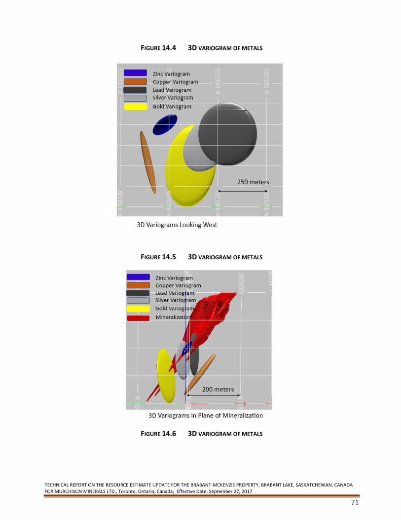
TECHNICAL REPORT ON THE RESOURCE ESTIMATE UPDATE FOR THE BRABANT-MCKENZIE PROPERTY, BRABANT LAKE, SASKATCHEWAN, CANADA FOR MURCHISON MINERALS LTD., Toronto, Ontario, Canada; Effective Date: September 27, 2017
71
FIGURE 14.4 3D VARIOGRAM OF METALS
FIGURE 14.5 3D VARIOGRAM OF METALS
FIGURE 14.6 3D VARIOGRAM OF METALS
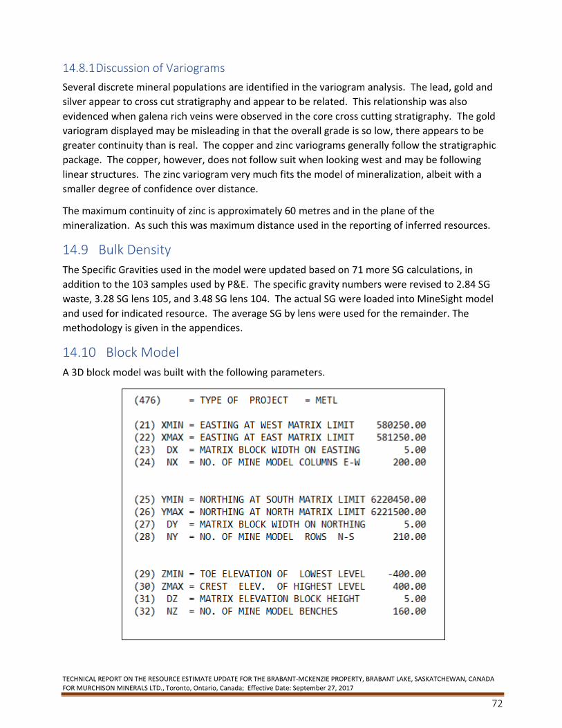
TECHNICAL REPORT ON THE RESOURCE ESTIMATE UPDATE FOR THE BRABANT-MCKENZIE PROPERTY, BRABANT LAKE, SASKATCHEWAN, CANADA FOR MURCHISON MINERALS LTD., Toronto, Ontario, Canada; Effective Date: September 27, 2017
72
14.8.1 Discussion of Variograms
Several discrete mineral populations are identified in the variogram analysis. The lead, gold and
silver appear to cross cut stratigraphy and appear to be related. This relationship was also
evidenced when galena rich veins were observed in the core cross cutting stratigraphy. The gold
variogram displayed may be misleading in that the overall grade is so low, there appears to be
greater continuity than is real. The copper and zinc variograms generally follow the stratigraphic
package. The copper, however, does not follow suit when looking west and may be following
linear structures. The zinc variogram very much fits the model of mineralization, albeit with a
smaller degree of confidence over distance.
The maximum continuity of zinc is approximately 60 metres and in the plane of the
mineralization. As such this was maximum distance used in the reporting of inferred resources.
14.9 Bulk Density
The Specific Gravities used in the model were updated based on 71 more SG calculations, in
addition to the 103 samples used by P&E. The specific gravity numbers were revised to 2.84 SG
waste, 3.28 SG lens 105, and 3.48 SG lens 104. The actual SG were loaded into MineSight model
and used for indicated resource. The average SG by lens were used for the remainder. The
methodology is given in the appendices.
14.10 Block Model
A 3D block model was built with the following parameters.
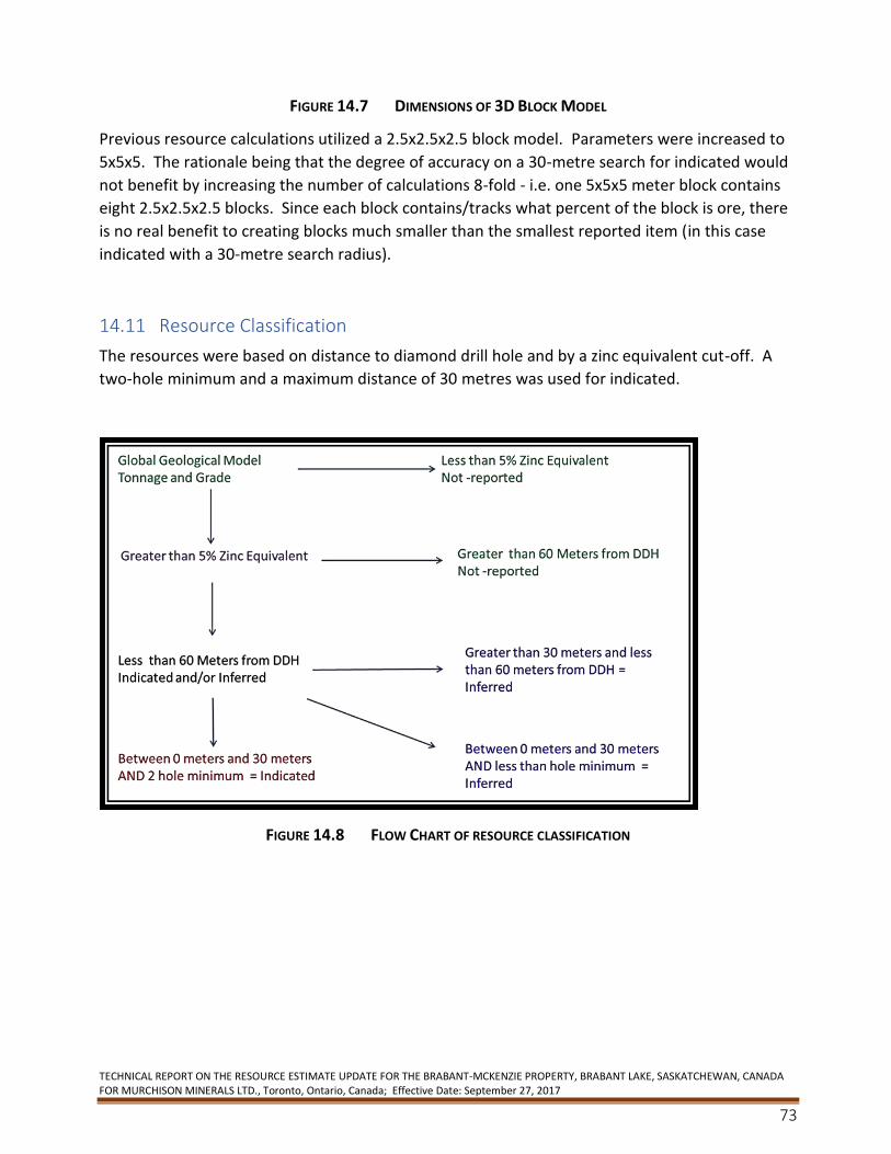
TECHNICAL REPORT ON THE RESOURCE ESTIMATE UPDATE FOR THE BRABANT-MCKENZIE PROPERTY, BRABANT LAKE, SASKATCHEWAN, CANADA FOR MURCHISON MINERALS LTD., Toronto, Ontario, Canada; Effective Date: September 27, 2017
73
FIGURE 14.7 DIMENSIONS OF 3D BLOCK MODEL
Previous resource calculations utilized a 2.5x2.5x2.5 block model. Parameters were increased to
5x5x5. The rationale being that the degree of accuracy on a 30-metre search for indicated would
not benefit by increasing the number of calculations 8-fold - i.e. one 5x5x5 meter block contains
eight 2.5x2.5x2.5 blocks. Since each block contains/tracks what percent of the block is ore, there
is no real benefit to creating blocks much smaller than the smallest reported item (in this case
indicated with a 30-metre search radius).
14.11 Resource Classification
The resources were based on distance to diamond drill hole and by a zinc equivalent cut-off. A
two-hole minimum and a maximum distance of 30 metres was used for indicated.
FIGURE 14.8 FLOW CHART OF RESOURCE CLASSIFICATION
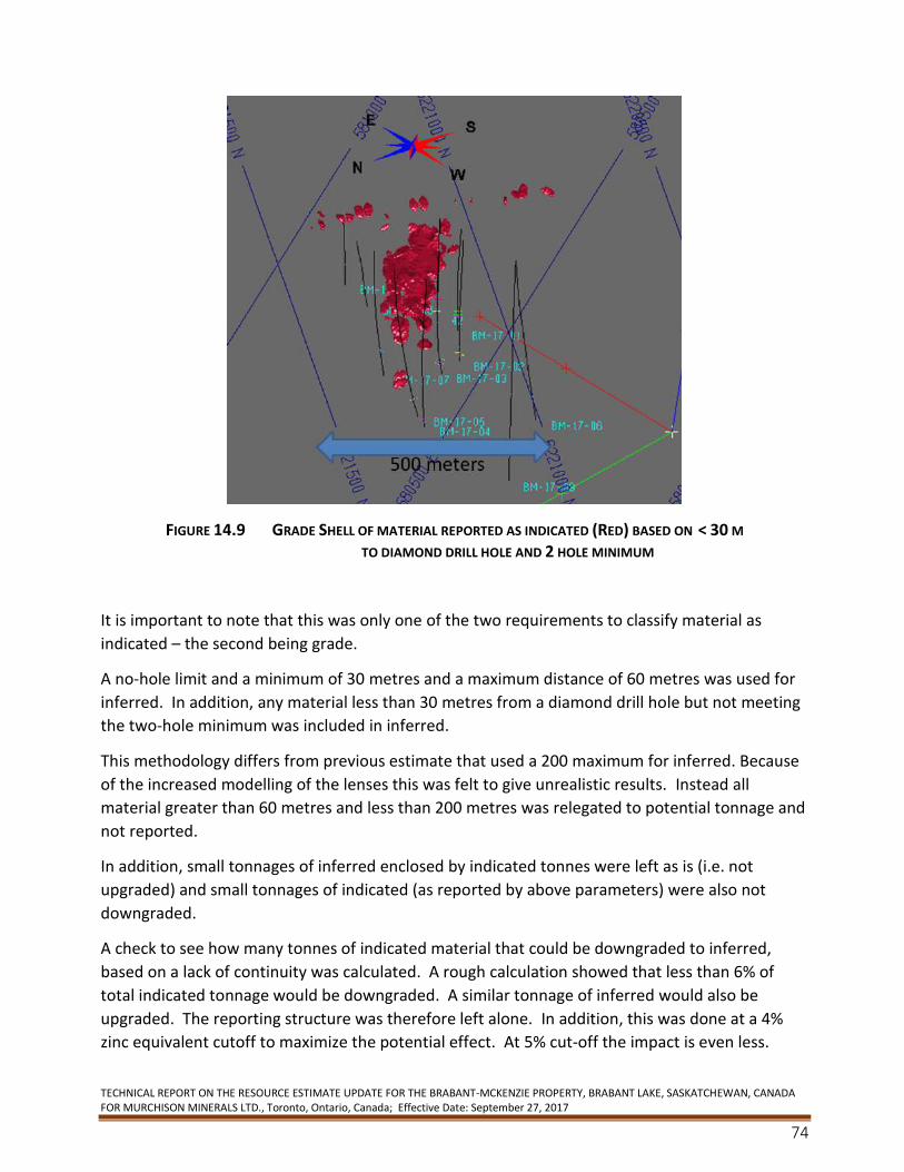
TECHNICAL REPORT ON THE RESOURCE ESTIMATE UPDATE FOR THE BRABANT-MCKENZIE PROPERTY, BRABANT LAKE, SASKATCHEWAN, CANADA FOR MURCHISON MINERALS LTD., Toronto, Ontario, Canada; Effective Date: September 27, 2017
74
FIGURE 14.9 GRADE SHELL OF MATERIAL REPORTED AS INDICATED (RED) BASED ON < 30 M TO DIAMOND DRILL HOLE AND 2 HOLE MINIMUM
It is important to note that this was only one of the two requirements to classify material as
indicated – the second being grade.
A no-hole limit and a minimum of 30 metres and a maximum distance of 60 metres was used for
inferred. In addition, any material less than 30 metres from a diamond drill hole but not meeting
the two-hole minimum was included in inferred.
This methodology differs from previous estimate that used a 200 maximum for inferred. Because
of the increased modelling of the lenses this was felt to give unrealistic results. Instead all
material greater than 60 metres and less than 200 metres was relegated to potential tonnage and
not reported.
In addition, small tonnages of inferred enclosed by indicated tonnes were left as is (i.e. not
upgraded) and small tonnages of indicated (as reported by above parameters) were also not
downgraded.
A check to see how many tonnes of indicated material that could be downgraded to inferred,
based on a lack of continuity was calculated. A rough calculation showed that less than 6% of
total indicated tonnage would be downgraded. A similar tonnage of inferred would also be
upgraded. The reporting structure was therefore left alone. In addition, this was done at a 4%
zinc equivalent cutoff to maximize the potential effect. At 5% cut-off the impact is even less.
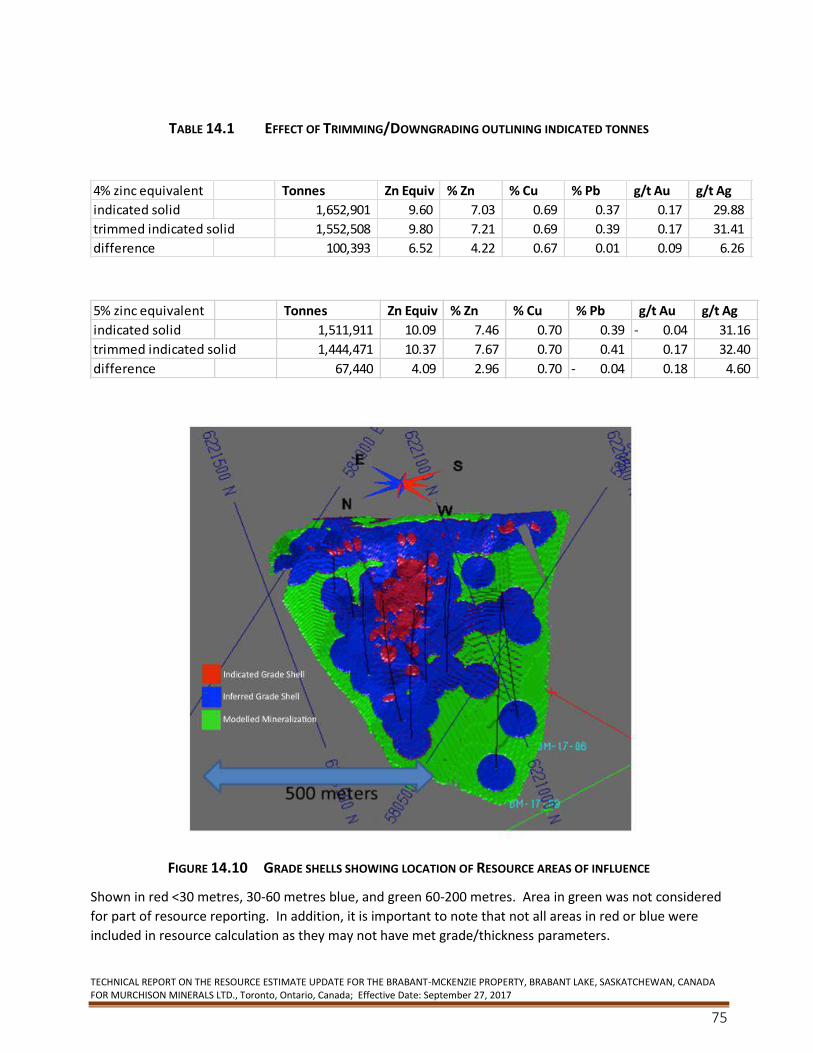
TECHNICAL REPORT ON THE RESOURCE ESTIMATE UPDATE FOR THE BRABANT-MCKENZIE PROPERTY, BRABANT LAKE, SASKATCHEWAN, CANADA FOR MURCHISON MINERALS LTD., Toronto, Ontario, Canada; Effective Date: September 27, 2017
75
TABLE 14.1 EFFECT OF TRIMMING/DOWNGRADING OUTLINING INDICATED TONNES
FIGURE 14.10 GRADE SHELLS SHOWING LOCATION OF RESOURCE AREAS OF INFLUENCE
Shown in red <30 metres, 30-60 metres blue, and green 60-200 metres. Area in green was not considered
for part of resource reporting. In addition, it is important to note that not all areas in red or blue were
included in resource calculation as they may not have met grade/thickness parameters.
4% zinc equivalent Tonnes Zn Equiv % Zn % Cu % Pb g/t Au g/t Ag
indicated solid 1,652,901 9.60 7.03 0.69 0.37 0.17 29.88
trimmed indicated solid 1,552,508 9.80 7.21 0.69 0.39 0.17 31.41
difference 100,393 6.52 4.22 0.67 0.01 0.09 6.26
5% zinc equivalent Tonnes Zn Equiv % Zn % Cu % Pb g/t Au g/t Ag
indicated solid 1,511,911 10.09 7.46 0.70 0.39 0.04- 31.16
trimmed indicated solid 1,444,471 10.37 7.67 0.70 0.41 0.17 32.40
difference 67,440 4.09 2.96 0.70 0.04- 0.18 4.60
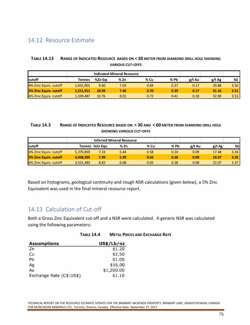
TECHNICAL REPORT ON THE RESOURCE ESTIMATE UPDATE FOR THE BRABANT-MCKENZIE PROPERTY, BRABANT LAKE, SASKATCHEWAN, CANADA FOR MURCHISON MINERALS LTD., Toronto, Ontario, Canada; Effective Date: September 27, 2017
76
14.12 Resource Estimate
TABLE 14.13 RANGE OF INDICATED RESOURCE BASED ON < 30 METER FROM DIAMOND DRILL HOLE SHOWING
VARIOUS CUT-OFFS
TABLE 14.3 RANGE OF INDICATED RESOURCE BASED ON > 30 AND < 60 METER FROM DIAMOND DRILL HOLE
SHOWING VARIOUS CUT-OFFS
Based on histograms, geological continuity and rough NSR calculations (given below), a 5% Zinc
Equivalent was used in the final mineral resource report.
14.13 Calculation of Cut-off
Both a Gross Zinc Equivalent cut-off and a NSR were calculated. A generic NSR was calculated
using the following parameters:
TABLE 14.4 METAL PRICES AND EXCHANGE RATE
Indicated Mineral Resource
cutoff Tonnes %Zn Equiv % Zn % Cu % Pb g/t Au g/t Ag SG
4% Zinc Equiv. cutoff 1,652,901 9.60 7.03 0.69 0.37 0.17 29.88 3.50
5% Zinc Equiv. cutoff 1,511,911 10.09 7.46 0.70 0.39 0.17 31.16 3.51
6% Zinc Equiv. cutoff 1,339,487 10.76 8.01 0.72 0.41 0.18 32.90 3.53
Inferred Mineral Resource
cutoff Tonnes %Zn Equiv % Zn % Cu % Pb g/t Au g/t Ag SG
4% Zinc Equiv. cutoff 5,370,859 7.33 5.44 0.58 0.24 0.09 17.48 3.34
5% Zinc Equiv. cutoff 4,458,395 7.99 5.99 0.62 0.28 0.09 19.37 3.35
6% Zinc Equiv. cutoff 3,521,483 8.82 6.68 0.65 0.28 0.08 22.07 3.37

TECHNICAL REPORT ON THE RESOURCE ESTIMATE UPDATE FOR THE BRABANT-MCKENZIE PROPERTY, BRABANT LAKE, SASKATCHEWAN, CANADA FOR MURCHISON MINERALS LTD., Toronto, Ontario, Canada; Effective Date: September 27, 2017
77
A 5% zinc equivalent was calculated based on values in above table and assumed similar recovery
of all metals.
TABLE 14.5 CALCULATION OF NSR /ZINC EQUIVALENT CUT OFF
Assuming an overall recovery (milling and smelting) of 75%, a 5% zinc equivalent equates to a
$110 NSR cutoff.
The 5% zinc equivalent was based on both economics as well as a tonnage grade curve indicated
that a significant portion of the tonnes and grade would be captured at this cutoff.
FIGURE 14.11 ZINC EQUIVALENT TONNAGE CURVE LIMITED TO UMZ AND LMZ
The histogram below also indicates that a cutoff between 4 to 5% zinc equivalent would ensure
that a bell curve would capture the bulk of the tonnes.
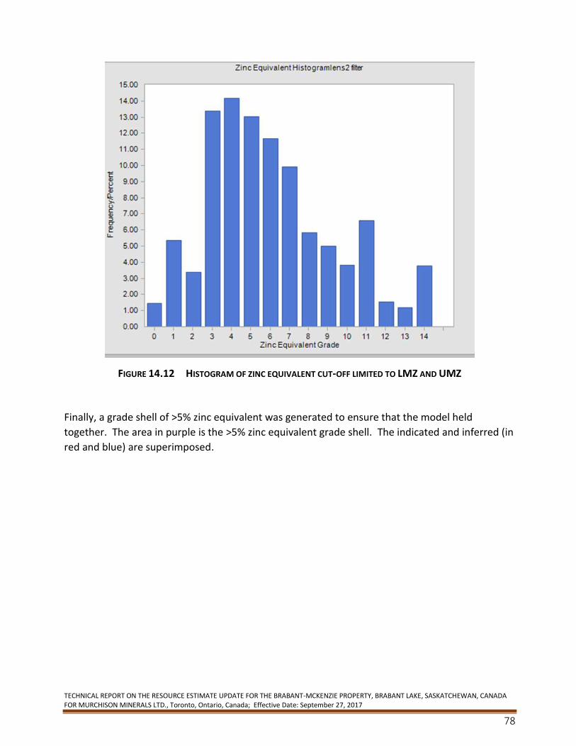
TECHNICAL REPORT ON THE RESOURCE ESTIMATE UPDATE FOR THE BRABANT-MCKENZIE PROPERTY, BRABANT LAKE, SASKATCHEWAN, CANADA FOR MURCHISON MINERALS LTD., Toronto, Ontario, Canada; Effective Date: September 27, 2017
78
FIGURE 14.12 HISTOGRAM OF ZINC EQUIVALENT CUT-OFF LIMITED TO LMZ AND UMZ
Finally, a grade shell of >5% zinc equivalent was generated to ensure that the model held
together. The area in purple is the >5% zinc equivalent grade shell. The indicated and inferred (in
red and blue) are superimposed.
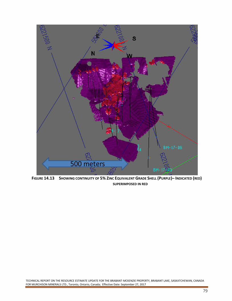
TECHNICAL REPORT ON THE RESOURCE ESTIMATE UPDATE FOR THE BRABANT-MCKENZIE PROPERTY, BRABANT LAKE, SASKATCHEWAN, CANADA FOR MURCHISON MINERALS LTD., Toronto, Ontario, Canada; Effective Date: September 27, 2017
79
FIGURE 14.13 SHOWING CONTINUITY OF 5% ZINC EQUIVALENT GRADE SHELL (PURPLE)– INDICATED (RED)
SUPERIMPOSED IN RED
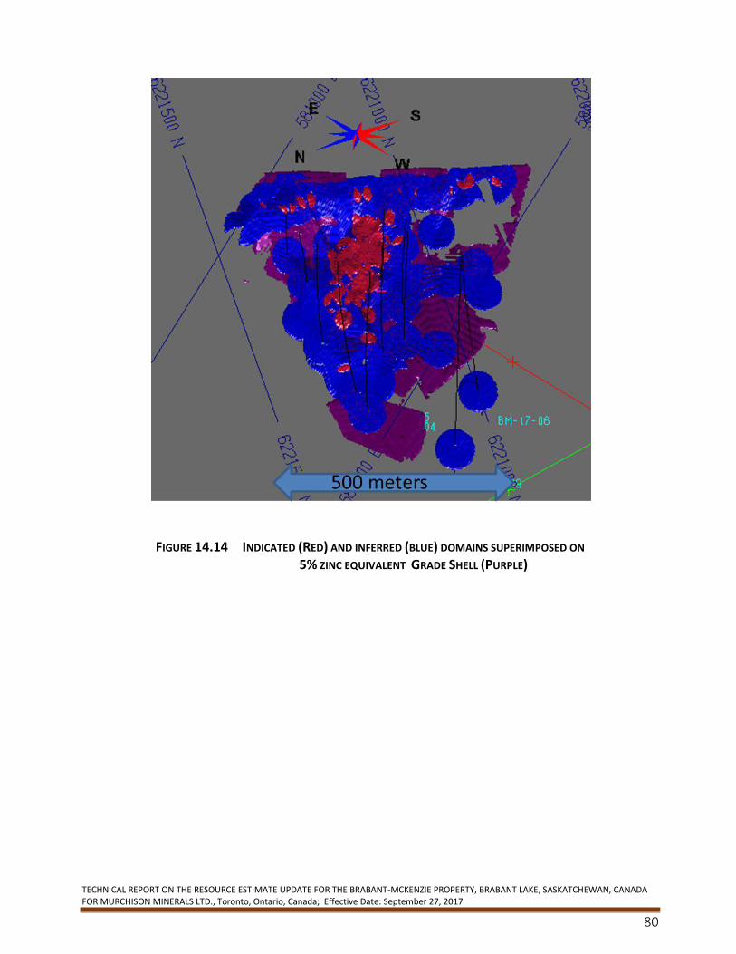
TECHNICAL REPORT ON THE RESOURCE ESTIMATE UPDATE FOR THE BRABANT-MCKENZIE PROPERTY, BRABANT LAKE, SASKATCHEWAN, CANADA FOR MURCHISON MINERALS LTD., Toronto, Ontario, Canada; Effective Date: September 27, 2017
80
FIGURE 14.14 INDICATED (RED) AND INFERRED (BLUE) DOMAINS SUPERIMPOSED ON 5% ZINC EQUIVALENT GRADE SHELL (PURPLE)
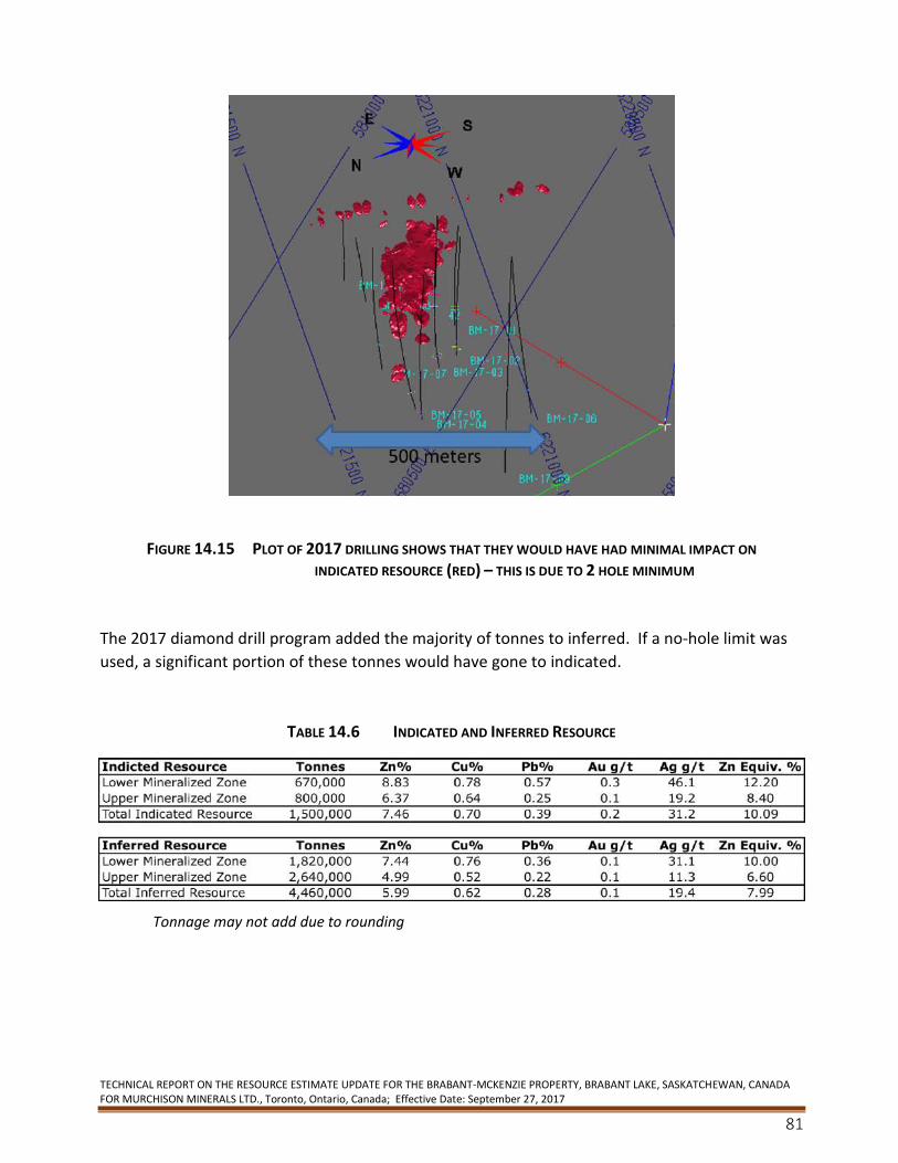
TECHNICAL REPORT ON THE RESOURCE ESTIMATE UPDATE FOR THE BRABANT-MCKENZIE PROPERTY, BRABANT LAKE, SASKATCHEWAN, CANADA FOR MURCHISON MINERALS LTD., Toronto, Ontario, Canada; Effective Date: September 27, 2017
81
FIGURE 14.15 PLOT OF 2017 DRILLING SHOWS THAT THEY WOULD HAVE HAD MINIMAL IMPACT ON INDICATED RESOURCE (RED) – THIS IS DUE TO 2 HOLE MINIMUM
The 2017 diamond drill program added the majority of tonnes to inferred. If a no-hole limit was
used, a significant portion of these tonnes would have gone to indicated.
TABLE 14.6 INDICATED AND INFERRED RESOURCE
Tonnage may not add due to rounding
TECHNICAL REPORT ON THE RESOURCE ESTIMATE UPDATE FOR THE BRABANT-MCKENZIE PROPERTY, BRABANT LAKE, SASKATCHEWAN, CANADA FOR MURCHISON MINERALS LTD., Toronto, Ontario, Canada; Effective Date: September 27, 2017
82
TABLE 14.7 SHOWING REPRESENTATIVE VALUE OF INDICATED RESOURCE
14.14 Confirmation of Estimate
The accuracy of the model reporting was verified in three ways:
1) Pitres (Minesite) was used to calculate the resource tonnage and grade.
2) UG1res (Minesite) was then used to compare resource estimate to the Pitres resource
tonnage and grade.
3) The 3d block model data was exported into excel and the resource tonnage and grade
results independently verified the data as reported by Minesite was correct.
14.15 Discussion of Results
As shown in the accompanying figure, the majority of the diamond drilling occurred outside of the
modeled area used in the 2008 resource domains. As such, it is apparent that the bulk of the
additional tonnage has come from the newly drilled areas and to a lesser degree, remodelling of
the deposit.
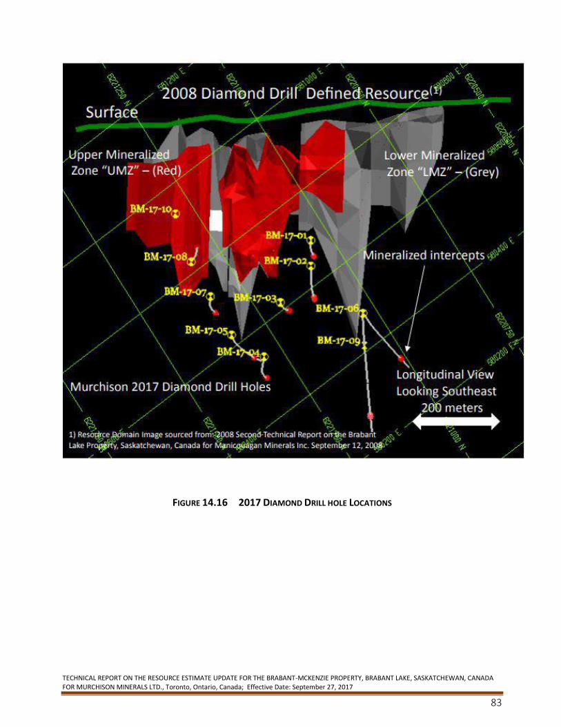
TECHNICAL REPORT ON THE RESOURCE ESTIMATE UPDATE FOR THE BRABANT-MCKENZIE PROPERTY, BRABANT LAKE, SASKATCHEWAN, CANADA FOR MURCHISON MINERALS LTD., Toronto, Ontario, Canada; Effective Date: September 27, 2017
83
FIGURE 14.16 2017 DIAMOND DRILL HOLE LOCATIONS
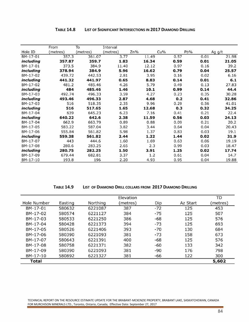
TECHNICAL REPORT ON THE RESOURCE ESTIMATE UPDATE FOR THE BRABANT-MCKENZIE PROPERTY, BRABANT LAKE, SASKATCHEWAN, CANADA FOR MURCHISON MINERALS LTD., Toronto, Ontario, Canada; Effective Date: September 27, 2017
84
TABLE 14.8 LIST OF SIGNIFICANT INTERSECTIONS IN 2017 DIAMOND DRILLING
TABLE 14.9 LIST OF DIAMOND DRILL COLLARS FROM 2017 DIAMOND DRILLING
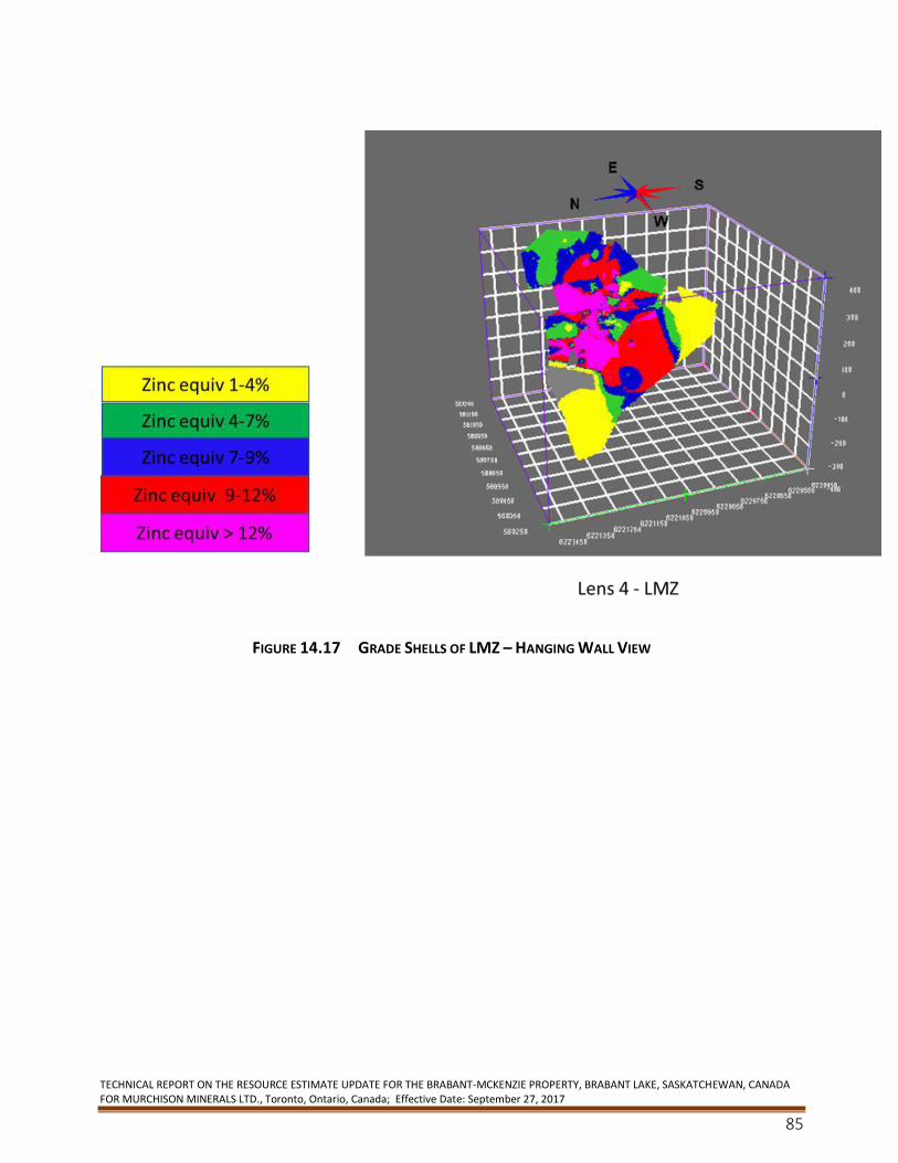
TECHNICAL REPORT ON THE RESOURCE ESTIMATE UPDATE FOR THE BRABANT-MCKENZIE PROPERTY, BRABANT LAKE, SASKATCHEWAN, CANADA FOR MURCHISON MINERALS LTD., Toronto, Ontario, Canada; Effective Date: September 27, 2017
85
FIGURE 14.17 GRADE SHELLS OF LMZ – HANGING WALL VIEW
TECHNICAL REPORT ON THE RESOURCE ESTIMATE UPDATE FOR THE BRABANT-MCKENZIE PROPERTY, BRABANT LAKE, SASKATCHEWAN, CANADA FOR MURCHISON MINERALS LTD., Toronto, Ontario, Canada; Effective Date: September 27, 2017
86
FIGURE 14.18 GRADE SHELLS OF UMZ - HANGING WALL VIEW
A series of grade shells were created for both mineralized zones. This was undertaken to confirm
the continuity of the mineralized zones as well as for future diamond drill and exploration targets.
15. Mineral Reserve Estimates N/A
16. Mining Methods N/A
17. Recovery Methods N/A
TECHNICAL REPORT ON THE RESOURCE ESTIMATE UPDATE FOR THE BRABANT-MCKENZIE PROPERTY, BRABANT LAKE, SASKATCHEWAN, CANADA FOR MURCHISON MINERALS LTD., Toronto, Ontario, Canada; Effective Date: September 27, 2017
87
18. Property Infrastructure N/A
19. Market Studies and Contracts N/A
20. Environmental Studies, Permitting and Social or Community Impact N/A
21. Capital and Operating Costs N/A
22. Economic Analysis N/A
23. Adjacent Properties There are no adjacent properties for comparison with the Brabant-McKenzie Deposit. However
there are other analogous deposits in other parts of the Canadian Shield. A number of gold
mining operations are present in the area but are currently on care and maintenance.
The reader is cautioned that the qualified person preparing this technical report has been unable
to verify the information and that the information in this section is not necessarily indicative of
the mineralization on the property that is the subject of this technical report.
The Property hosts a massive sulphide deposit similar in many respects to those of the
Manitouwadge, Ontario and Sherridon, Manitoba mining camps. Numerous known mineralized
showings and geophysical conductors are present along the strike length of the Property. Massive
sulphide deposits tend to cluster and as such the adjacent ground may have the potential to host
similar mineralization but insufficient work has been completed to properly evaluate its potential.
The Brabant-McKenzie deposit appears to still be open laterally both to the northeast and
southwest as well as to depth. It is not clear at this time, however, whether the Deposit trends
off M.L. 5054 onto the adjacent claims.
24. Other Relevant Data and Information N/A
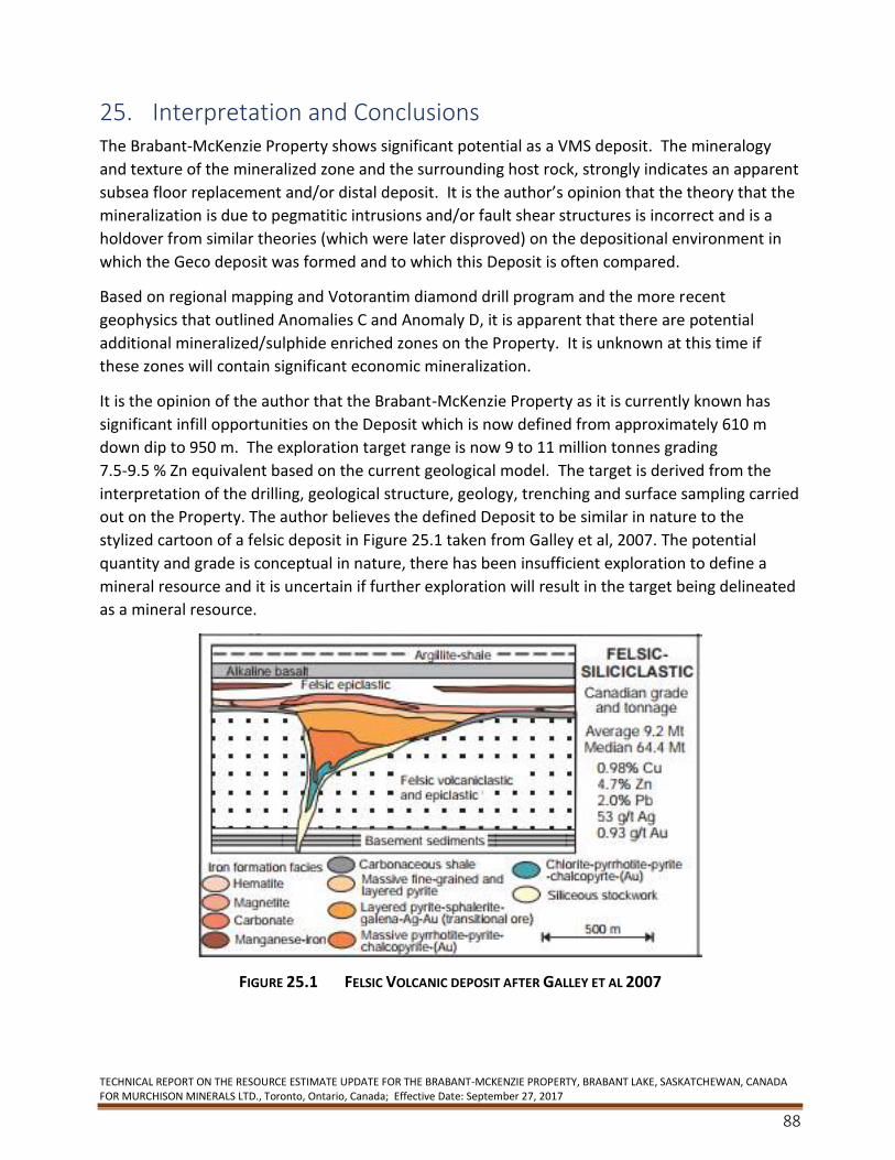
TECHNICAL REPORT ON THE RESOURCE ESTIMATE UPDATE FOR THE BRABANT-MCKENZIE PROPERTY, BRABANT LAKE, SASKATCHEWAN, CANADA FOR MURCHISON MINERALS LTD., Toronto, Ontario, Canada; Effective Date: September 27, 2017
88
25. Interpretation and Conclusions The Brabant-McKenzie Property shows significant potential as a VMS deposit. The mineralogy
and texture of the mineralized zone and the surrounding host rock, strongly indicates an apparent
subsea floor replacement and/or distal deposit. It is the author’s opinion that the theory that the
mineralization is due to pegmatitic intrusions and/or fault shear structures is incorrect and is a
holdover from similar theories (which were later disproved) on the depositional environment in
which the Geco deposit was formed and to which this Deposit is often compared.
Based on regional mapping and Votorantim diamond drill program and the more recent
geophysics that outlined Anomalies C and Anomaly D, it is apparent that there are potential
additional mineralized/sulphide enriched zones on the Property. It is unknown at this time if
these zones will contain significant economic mineralization.
It is the opinion of the author that the Brabant-McKenzie Property as it is currently known has
significant infill opportunities on the Deposit which is now defined from approximately 610 m
down dip to 950 m. The exploration target range is now 9 to 11 million tonnes grading
7.5-9.5 % Zn equivalent based on the current geological model. The target is derived from the
interpretation of the drilling, geological structure, geology, trenching and surface sampling carried
out on the Property. The author believes the defined Deposit to be similar in nature to the
stylized cartoon of a felsic deposit in Figure 25.1 taken from Galley et al, 2007. The potential
quantity and grade is conceptual in nature, there has been insufficient exploration to define a
mineral resource and it is uncertain if further exploration will result in the target being delineated
as a mineral resource.
FIGURE 25.1 FELSIC VOLCANIC DEPOSIT AFTER GALLEY ET AL 2007
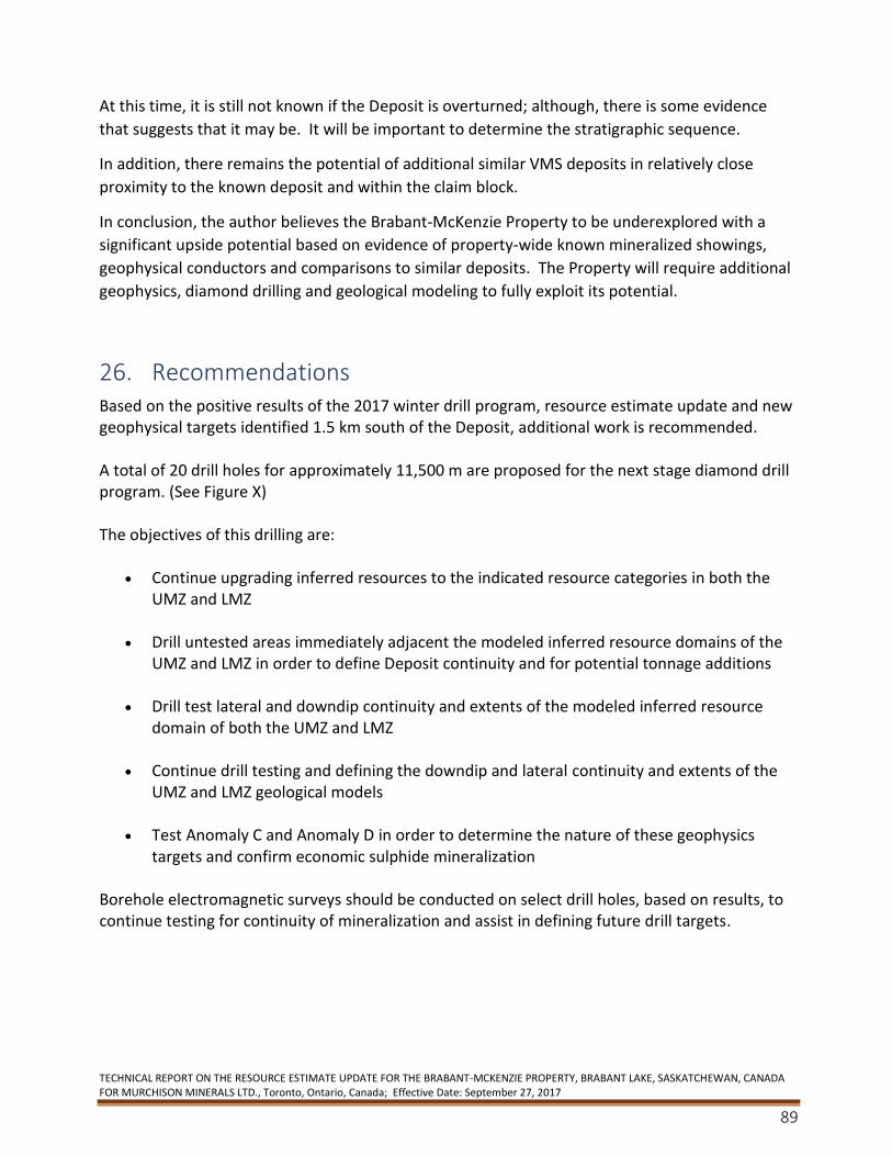
TECHNICAL REPORT ON THE RESOURCE ESTIMATE UPDATE FOR THE BRABANT-MCKENZIE PROPERTY, BRABANT LAKE, SASKATCHEWAN, CANADA FOR MURCHISON MINERALS LTD., Toronto, Ontario, Canada; Effective Date: September 27, 2017
89
At this time, it is still not known if the Deposit is overturned; although, there is some evidence
that suggests that it may be. It will be important to determine the stratigraphic sequence.
In addition, there remains the potential of additional similar VMS deposits in relatively close
proximity to the known deposit and within the claim block.
In conclusion, the author believes the Brabant-McKenzie Property to be underexplored with a
significant upside potential based on evidence of property-wide known mineralized showings,
geophysical conductors and comparisons to similar deposits. The Property will require additional
geophysics, diamond drilling and geological modeling to fully exploit its potential.
26. Recommendations Based on the positive results of the 2017 winter drill program, resource estimate update and new geophysical targets identified 1.5 km south of the Deposit, additional work is recommended. A total of 20 drill holes for approximately 11,500 m are proposed for the next stage diamond drill program. (See Figure X) The objectives of this drilling are:
• Continue upgrading inferred resources to the indicated resource categories in both the UMZ and LMZ
• Drill untested areas immediately adjacent the modeled inferred resource domains of the UMZ and LMZ in order to define Deposit continuity and for potential tonnage additions
• Drill test lateral and downdip continuity and extents of the modeled inferred resource domain of both the UMZ and LMZ
• Continue drill testing and defining the downdip and lateral continuity and extents of the UMZ and LMZ geological models
• Test Anomaly C and Anomaly D in order to determine the nature of these geophysics targets and confirm economic sulphide mineralization
Borehole electromagnetic surveys should be conducted on select drill holes, based on results, to continue testing for continuity of mineralization and assist in defining future drill targets.
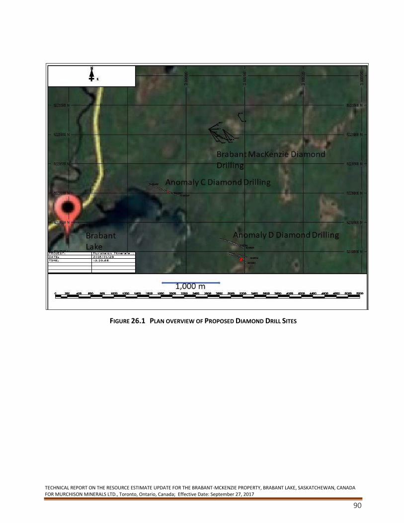
TECHNICAL REPORT ON THE RESOURCE ESTIMATE UPDATE FOR THE BRABANT-MCKENZIE PROPERTY, BRABANT LAKE, SASKATCHEWAN, CANADA FOR MURCHISON MINERALS LTD., Toronto, Ontario, Canada; Effective Date: September 27, 2017
90
FIGURE 26.1 PLAN OVERVIEW OF PROPOSED DIAMOND DRILL SITES
TECHNICAL REPORT ON THE RESOURCE ESTIMATE UPDATE FOR THE BRABANT-MCKENZIE PROPERTY, BRABANT LAKE, SASKATCHEWAN, CANADA FOR MURCHISON MINERALS LTD., Toronto, Ontario, Canada; Effective Date: September 27, 2017
91
FIGURE 26.2 SECTION LOOKING WEST OF ANOMALY C AND ANOMALY D
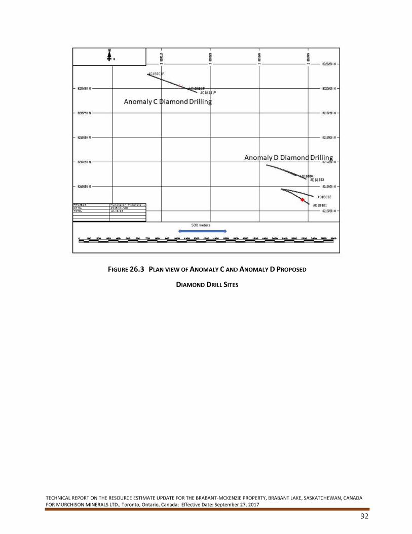
TECHNICAL REPORT ON THE RESOURCE ESTIMATE UPDATE FOR THE BRABANT-MCKENZIE PROPERTY, BRABANT LAKE, SASKATCHEWAN, CANADA FOR MURCHISON MINERALS LTD., Toronto, Ontario, Canada; Effective Date: September 27, 2017
92
FIGURE 26.3 PLAN VIEW OF ANOMALY C AND ANOMALY D PROPOSED
DIAMOND DRILL SITES
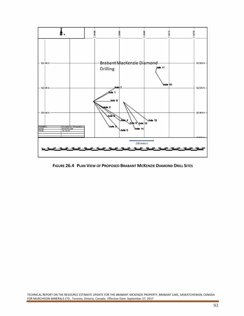
TECHNICAL REPORT ON THE RESOURCE ESTIMATE UPDATE FOR THE BRABANT-MCKENZIE PROPERTY, BRABANT LAKE, SASKATCHEWAN, CANADA FOR MURCHISON MINERALS LTD., Toronto, Ontario, Canada; Effective Date: September 27, 2017
93
FIGURE 26.4 PLAN VIEW OF PROPOSED BRABANT MCKENZIE DIAMOND DRILL SITES
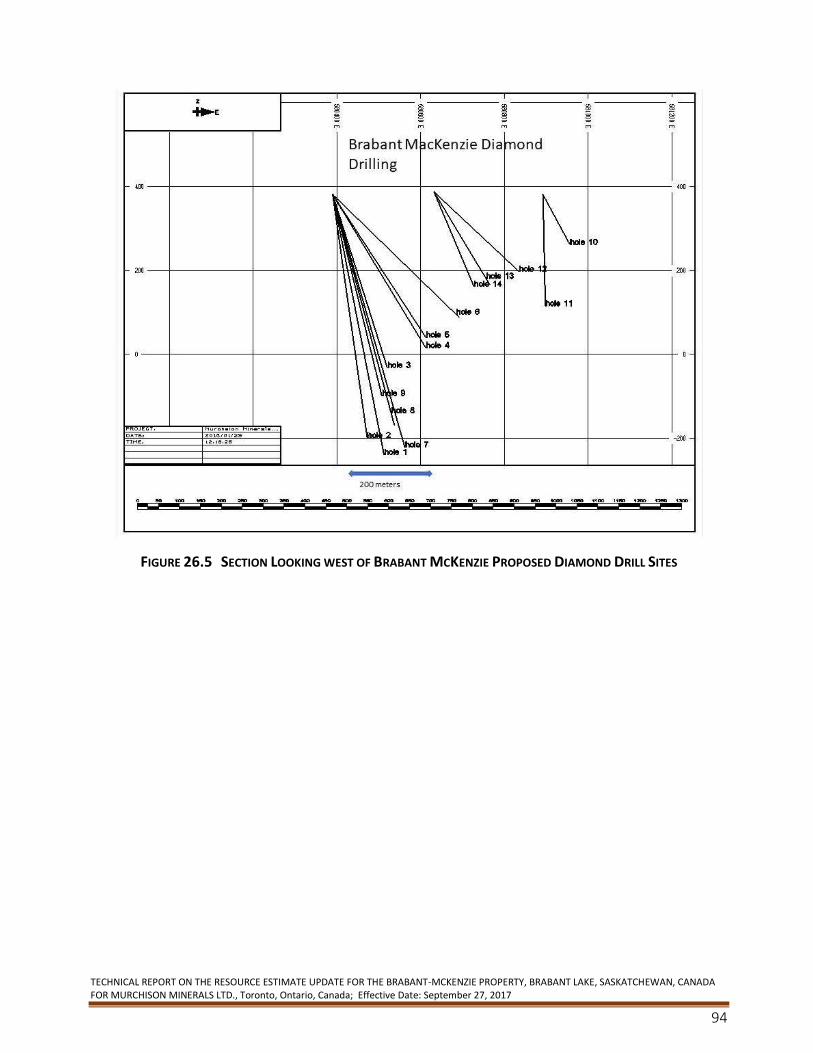
TECHNICAL REPORT ON THE RESOURCE ESTIMATE UPDATE FOR THE BRABANT-MCKENZIE PROPERTY, BRABANT LAKE, SASKATCHEWAN, CANADA FOR MURCHISON MINERALS LTD., Toronto, Ontario, Canada; Effective Date: September 27, 2017
94
FIGURE 26.5 SECTION LOOKING WEST OF BRABANT MCKENZIE PROPOSED DIAMOND DRILL SITES
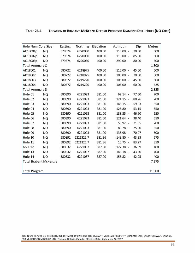
TECHNICAL REPORT ON THE RESOURCE ESTIMATE UPDATE FOR THE BRABANT-MCKENZIE PROPERTY, BRABANT LAKE, SASKATCHEWAN, CANADA FOR MURCHISON MINERALS LTD., Toronto, Ontario, Canada; Effective Date: September 27, 2017
95
TABLE 26.1 LOCATION OF BRABANT-MCKENZIE DEPOSIT PROPOSED DIAMOND DRILL HOLES (NQ CORE)
Hole NumberCore Size Easting Northing Elevation Azimuth Dip Meters
AC18001p NQ 579674 6220030 400.00 110.00 70.00- 600
AC18002p NQ 579674 6220030 400.00 110.00 85.00- 600
AC18003p NQ 579674 6220030 400.00 290.00 80.00- 600
Total Anomaly C 1,800
AD18001 NQ 580722 6218975 400.00 115.00 45.00- 600
AD18002 NQ 580722 6218975 400.00 100.00 70.00- 500
AD18003 NQ 580572 6219220 400.00 105.00 45.00- 600
AD18004 NQ 580572 6219220 400.00 105.00 60.00- 625
Total Anomaly D 2,325
Hole 01 NQ 580390 6221093 381.00 62.14 77.50- 700
Hole 02 NQ 580390 6221093 381.00 124.15 80.26- 700
Hole 03 NQ 580390 6221093 381.00 148.15 59.03- 550
Hole 04 NQ 580390 6221093 381.00 125.80 53.15- 550
Hole 05 NQ 580390 6221093 381.00 138.35 46.60- 550
Hole 06 NQ 580390 6221093 381.00 121.64 38.40- 550
Hole 07 NQ 580390 6221093 381.00 58.92 71.55- 700
Hole 08 NQ 580390 6221093 381.00 89.78 75.00- 650
Hole 09 NQ 580390 6221093 381.00 136.98 70.27- 600
Hole 10 NQ 580892 6221326.7 381.36 148.80 43.83- 275
Hole 11 NQ 580892 6221326.7 381.36 10.75 83.27- 350
hole 12 NQ 580632 6221087 387.00 127.38 36.59- 400
Hole 13 NQ 580632 6221087 387.00 145.18 43.50- 400
Hole 14 NQ 580632 6221087 387.00 156.82 42.95- 400
Total Brabant McKenzie 7,375
Total Program 11,500
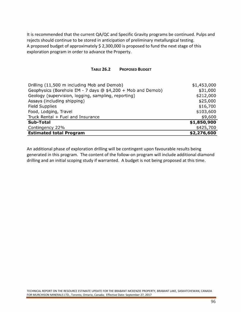
TECHNICAL REPORT ON THE RESOURCE ESTIMATE UPDATE FOR THE BRABANT-MCKENZIE PROPERTY, BRABANT LAKE, SASKATCHEWAN, CANADA FOR MURCHISON MINERALS LTD., Toronto, Ontario, Canada; Effective Date: September 27, 2017
96
It is recommended that the current QA/QC and Specific Gravity programs be continued. Pulps and rejects should continue to be stored in anticipation of preliminary metallurgical testing. A proposed budget of approximately $ 2,300,000 is proposed to fund the next stage of this exploration program in order to advance the Property.
TABLE 26.2 PROPOSED BUDGET
An additional phase of exploration drilling will be contingent upon favourable results being generated in this program. The content of the follow-on program will include additional diamond drilling and an initial scoping study if warranted. A budget is not being proposed at this time.
TECHNICAL REPORT ON THE RESOURCE ESTIMATE UPDATE FOR THE BRABANT-MCKENZIE PROPERTY, BRABANT LAKE, SASKATCHEWAN, CANADA FOR MURCHISON MINERALS LTD., Toronto, Ontario, Canada; Effective Date: September 27, 2017
97
27. References Alcock, F.S., 1939: Olive Lake, northern Saskatchewan. Geological Survey of Canada Map 528A with
descriptive notes.
Abbas-Hasanie, S.A.F., Lewry, J.F. and Perkins, D., 1992: Metamorphism of high grade pelites in the
Brabant Lake area, eastern La Ronge Domain, northern Saskatchewan. Canadian Journal of Earth Sciences,
29, pp. 1686-1700.
Bakker, Finley., 1979, Petrology and Geochemistry of the Quartz Pebble Conglomerate of the Geco Massie
Sulphide Deposit at Manitouwadge, Ont. – Unpub BSc Thesis McMaster University
Barclay, W.A., 1993: Geological Mapping, Review of Core, Drilling Proposal, Brabant Lake Deposit. Internal
report prepared for Phelps Dodge Corporation of Canada, Limited, 50p.
Barrie, C.T. and Hannington, M.D., 1999: Classification of VMS deposits on host rock composition, in Barrie,
C.T. and Hannington, M.D., eds., Volcanic-Associated Massive Sulfide Deposits: Processes and Examples in
Modern and Ancient Settings: Reviews in Economic Geology, v.8, p. 2-10.
Berry, T.F., 1965: Flotation of a Copper-Zinc Ore from the Brabant Lake Area, Northern Saskatchewan.
Dept. of Mines and Technical Surveys, Mineral Processing Division, 7p.
Bickford, M.E., Collerson, K.D., Lewry, J.F., van Schmus, W.R. and Chiarenzelli, J.R., 1990: Proterozoic
collisional tectonism in the Trans-Hudson Orogen, Saskatchewan. Geology, 18, pp. 14-18.
Byers, A.R., 1959: Base metal mineralization associated with pegmatite, northern Saskatchewan.
Proceedings of the Geological Association of Canada, 11, pp. 81-88.
Byers, A.R., 1962: Report on the PEG Group of Claims, Brabant Lake, Northern Saskatchewan. Internal
report prepared for Bison Petroleum & Minerals Limited and Prairie West Explorations Ltd., 16p.
Byers, A.R., 1964: Supplementary Report on the PEG Group of Claims, Brabant Lake, Northern
Saskatchewan. Report prepared for Bison Petroleum & Minerals Limited and Prairie West Explorations
Ltd., 6p.
Chamois, P., 1992: Report of the 1988-1989 Drilling Program on Mineral Lease 5054, Brabant Lake
Property, Saskatchewan, NTS 64D/4. Saskatchewan Assessment Report Number 64D040171, 9p.
Coombe Geological Consultants, 1991: Base metals in Saskatchewan. Saskatchewan Energy and Mines,
Geological Survey Open File Report 91-1.
Davison, J.G. and Davison, N.A., 1994: Lakefield Research #8900-687 Ore Petrography
Deptuck, R.J., 2006: Brabant Lake Property, NI 43-101 Requirements for Mineral Resource Estimates.
Memo prepared for MPH Consulting Limited, 3p.
Deptuck, R.J., 1994: Geological Study of the Drill Logs at the Brabant Lake Property, Northern
Saskatchewan for Phelps Dodge Corporation, Limited, 30p.
Durocher, M.E., 1993a: Summary Report, April 1993 Diamond Drilling Program, Brabant Lake Property,
Saskatchewan. Report prepared for Phelps Dodge Corporation of Canada, Limited, 20p.
TECHNICAL REPORT ON THE RESOURCE ESTIMATE UPDATE FOR THE BRABANT-MCKENZIE PROPERTY, BRABANT LAKE, SASKATCHEWAN, CANADA FOR MURCHISON MINERALS LTD., Toronto, Ontario, Canada; Effective Date: September 27, 2017
98
Durocher, M.E., 1993b: Summary Report, August-September 1993 Diamond Drilling, Brabant Lake
Property, Saskatchewan. Report prepared for Phelps Dodge Corporation of Canada, Limited, 20p.
Durocher, M.E., 1992: Geology of the Brabant Lake Property – Saskatchewan. Report prepared for Phelps
Dodge Corporation of Canada, Limited, 32p.
Friesen, R.G., Pierce, G,A and Weeks , R.M., 1978, Geology of the Geco Base Metal Deposit at
Manitouwadge, Ont., Canada presented at the Robinson Symposium on Precambrian Sulphide Deposits,
Toronto
Froese, E. and Goetz, P.A., 1981: Geology of the Sherridon Group in the Vicinity of Sherridon, Manitoba.
Energy, Mines & Resources Canada.
Galley, A., Hannington, M. and Jonasson, I., 2007: Volcanogenic Massive Sulphide Deposits; Consolidation
and Synthesis of Mineral Deposits Knowledge web site, Geological Survey of Canada
(http://gsc.nrcan.gc.ca/mindep/synth_dep/vms)
Gilligan, L.B. and Marshall, B., 1987: Textural evidence for remobilization in metamorphic environments.
Ore Geology Reviews, 2, pp. 205-229.
Gemmell, J. Bruce; February 28 ,2017, personal communication.
Gemmell, J. Bruce, Ancient and Modern VHMS Deposits; 2015 Presented at VIX Meeting, Campbell River,
B.C
Hanks, J.T. and Rood, E.A., 1994: Brabant Lake Property Metallurgical Test Report No.1. Report prepared
for Phelps Dodge Corporation of Canada, Limited, 5p.
Harper, C.T., 1996; La Ronge – Lynn Lake Bridge Property: Sucker Lake – Fleming Lake area. In Summary of
Investigations, 1996. Saskatchewan Geological Survey, Saskatchewan Energy and Mines, Miscellaneous
Report 96-4, pp. 66-78.
Harper, C.T., 1997: Sucker Lake – Fleming Lake update. In Summary of Investigations, 1997. Saskatchewan
Geological Survey. Saskatchewan Energy and Mines, Miscellaneous Report 97-4, pp. 42-50.
Harron, G., Yassa A., Puritch, E., 2008: SECOND TECHNICAL REPORT ON THE BRABANT LAKE Property,
SASKATCHEWAN, CANADA FOR MANICOUAGAN MINERALS INC.
Hawkins, T.G. and Naas, C.O., 1989: Preliminary Geological Resources Evaluation with a Recommended
Advanced Exploration Program, Brabant Lake Property for Gamsan Resources Ltd., Volume I of II, 21p.
Hawkins, T.G and Neale, T., 1988: Summary Report on Mineral Lease ML5054 (Peg 1-21 Claims), Brabant
Lake, Saskatchewan, NTS 64D/4. Report prepared for Gamsan Resources Ltd.
Jagodits, F.J., 1993: Report on ground magnetic, VLF-EM and horizontal loop electromagnetic surveys,
Brabant Property, Brabant Lake Property, La Ronge area, Saskatchewan, NTS 64/D. Report prepared for
Phelps Dodge Corporation of Canada, Limited.
Johnston, W.G.Q., Thomas, M.W., 1984: Compilation Bedrock Geology, Reindeer Lake South, NTS Area
64D; Saskatchewan Energy and Mines, Report 230 (1:250,000 scale map with marginal notes.)
TECHNICAL REPORT ON THE RESOURCE ESTIMATE UPDATE FOR THE BRABANT-MCKENZIE PROPERTY, BRABANT LAKE, SASKATCHEWAN, CANADA FOR MURCHISON MINERALS LTD., Toronto, Ontario, Canada; Effective Date: September 27, 2017
99
Johnston, W.G.Q. 1972: Base metal geochemistry, Brabant Lake area, Saskatchewan. Saskatchewan
Department of Natural Resources, Geological Survey Report No. 148.
Kirkland, S.T.J. 1968: Summary Internal Report for Bison Petroleum and Minerals Ltd.
Kirkland, S.T.J., 1959: The geology of the Brabant Lake area, Saskatchewan. Saskatchewan Department of
Mineral Resources, Report 33, 31p.
Kleespies, P.A., 1993: Geology of the Brabant Lake Polymetallic Sulphide Deposit, Northern Saskatchewan.
Research Property submitted to Dr. R.D. Morton, University of Alberta, 22p.
Klemenchuk, F. J., 1966: Report on 1965 and 1966 Diamond Drilling on the PEG Group of Claims, Brabant
Lake, Northern Saskatchewan, NTS 64-D-4. Report prepared for Rio Tinto Canadian Exploration Limited, 8p.
Knowles, D.M., 1968: Summary Internal Report for Canadian Javelin Ltd.
Lewry, J.F., 1983: Character and structural relations of the McLennan Group meta-arkoses, McLennan-
Jaysmith Lakes area, In Summary of Investigations, 1983. Saskatchewan Geological Survey, Miscellaneous
Paper 83-4, pp. 48-51.
Marshall, I.B. and Schut, P.H., 1999: A National Ecological Framework for Canada – Overview. A
cooperative product by Ecosystems Science Directorate, Environment Canada and Research Branch,
Agriculture and Agri-Food Canada.
MacConnell, Stepehen, 2012, Evaluation Report, Diamond Drilling , Brabant Lake Property, Northern
Saskatchewan Claim Groups
McDonald, R., 1987: Update on the Precambrian geology and domainal classification of northern
Saskatchewan. In Summary of Investigations, 1987. Saskatchewan Geological Survey, Miscellaneous Paper
87-4, pp. 87-104.
Morton, R.D. and Kleespies, P.A., 1990: Summary Geological Report, the Brabant Lake Zn-CuPb- (Ag, Au)
Deposit, Northern Saskatchewan, Canada. Report prepared for Gamsan Resources Ltd., 16p.
Pearl Pentney, Sandra, THE ARCHAEOLOGY OF BRABANT LAKE, A Thesis Submitted to the College of
Graduate Studies and Research in Partial Fulfilment of the Requirements for the Degree of Master of Arts
in the Department of Anthropology and Archaeology, University of Saskatchewan, Saskatoon by Sandra
Pearl Pentney, Fall 2002
Petrina, M; 2017 personal communication
Poulsen, K.H., Ames, D.E., Galley, A.G., Derome, I. and Brommecker, R., 1987: Structural studies in the
northern part of the La Ronge Domain. In Summary of Investigations, 1987. Saskatchewan Geological
Survey, Miscellaneous Paper 87-4, pp. 107-114.
Sangster, D.F., 1978: Isotopic studies of ore lead of the circum-Kisseynew volcanic belt of Manitoba and
Saskatchewan. Canadian Journal of Earth Science, 15, pp. 1112-1121.
(Government of) Saskatchewan GeoAtlas Mapping website. Geology of Brabant-McKenzie area. Retrieved
November 13, 2017 from https://gisappl.saskatchewan.ca/Html5Ext/index.html?viewer=GeoAtlas
TECHNICAL REPORT ON THE RESOURCE ESTIMATE UPDATE FOR THE BRABANT-MCKENZIE PROPERTY, BRABANT LAKE, SASKATCHEWAN, CANADA FOR MURCHISON MINERALS LTD., Toronto, Ontario, Canada; Effective Date: September 27, 2017
100
Scott, B.P., 1991: Metallogenic Map Series, Reindeer Lake South, NTS Area 64D; Saskatchewan Energy and
Mines, Report 253, 18p (accompanied by 1:250,000 scale map).
Stanton, R.L., 1972: Ore Petrology, McGraw Hill Book Company, Chapter 15.
Stewart, P.W. and Chamois, P., 1994: Summary Report, Brabant Property (McKenzie Zn-Cu-Ag Deposit),
Saskatchewan, NTS 64 D/4. Report prepared for Phelps Dodge Corporation of Canada, Limited, 26p.
Thomas, D.J., 1984: Geological mapping, Star Lake area (part of 73P-16 and 74A-1). In Summary of
Investigations, 1984. Saskatchewan Geological Survey, Miscellaneous Paper 84-4,
TECHNICAL REPORT ON THE RESOURCE ESTIMATE UPDATE FOR THE BRABANT-MCKENZIE PROPERTY, BRABANT LAKE, SASKATCHEWAN, CANADA FOR MURCHISON MINERALS LTD., Toronto, Ontario, Canada; Effective Date: September 27, 2017
101
Statement of Qualifications I, Finley J. Bakker, P. Geo, as the author of this technical report entitled, “TECHNICAL REPORT ON
THE BRABANT-MCKENZIE PROPERTY, SASKATCHEWAN, CANADA FOR MURCHISON MINERALS
LTD.”, prepared for MURCHISON MINERALS LTD., with mailing address Suite 2500, 120 Adelaide
Street West, Toronto, Ontario M5H 1T1, Canada, Tel: 416.350.3776, and dated September 22,
2017 do hereby certify that:
1. I am a Professional Geoscientist and Consultant, residing at 4798 Andy Road, Campbell River,
British Columbia, V9H 1C6.
2. I graduated with a degree in BSc. Honours in Geology from the McMaster University in 1979.
3. I am a member of the Association of Professional Engineers and Geoscientists of British
Columbia (1991) with APEGBC (1991) (registration No. 18639).
4. I have worked as a geologist for a total of 38 years since my graduation from university.
5. I have read the definition of “qualified person” as set out in National Instrument 43-101
(“NI 43-101”) and certify that by reason of my education, affiliation with a professional
association (as defined in NI 43-101), and past relevant work experience, I fulfill the
requirements to be a “qualified person” for the purposes of NI 43-101.
6. My relevant experience for the purpose of the Technical Report is:
a. Chief Geologist at four mines,
b. I have also held the positions of Senior Resource Geologist, Exploration Manager
and Superintendent of Technical Services,
c. I have undertaken Resource calculations for 36 years,
d. I have worked on a number of deposit types including VMS, skarn, epigenetic and
porphyry deposits and have specifically worked at and on Massive Sulphide deposits for 26
years.
e. I have been involved with commodities including copper, lead, zinc, gold, silver, REE,
tungsten and iron, and
f. I have used MineSight/Compass/Hexagon software used in calculating the Mineral
Resource for 29 years.
7. I am responsible for all of the items in the technical report titled “entitled “TECHNICAL
REPORT ON RESOURCE ESTIMATE UPDATE FOR THE BRABANT MCKENZIE PROPERTY,
BRABANT LAKE, SASKATCHEWAN, CANADA FOR MURCHISON MINERALS LTD.”
8. I have had prior involvement with the property that is the subject of the Technical Report.
The nature of my prior involvement is: I have worked at the site from February 2017 to
March 2017, as well as ongoing consulting to Murchison Minerals.
TECHNICAL REPORT ON THE RESOURCE ESTIMATE UPDATE FOR THE BRABANT-MCKENZIE PROPERTY, BRABANT LAKE, SASKATCHEWAN, CANADA FOR MURCHISON MINERALS LTD., Toronto, Ontario, Canada; Effective Date: September 27, 2017
102
9. That, at the effective date of the technical report, to the best of my knowledge, information
and belief, the technical report contains all scientific and technical information that is
required to be disclosed to make the technical report not misleading.
10. I am independent of the issuer applying all of the tests in section 1.5 of National Instrument
43-101.
11. I have read National Instrument 43-101 and Form 43-101F1, and the Technical Report has
been prepared in compliance with that instrument and form.
12. I consent to the filing of the Technical Report with any stock exchange and other regulatory
authority and any publication by them for regulatory purposes, including electronic
publication in the public Company files on their websites accessible by the public, of the
Technical Report.
Dated this 17th day of November 2017
//signed Finley Bakker
Finley J. Bakker, P.Geo.

TECHNICAL REPORT ON THE RESOURCE ESTIMATE UPDATE FOR THE BRABANT-MCKENZIE PROPERTY, BRABANT LAKE, SASKATCHEWAN, CANADA FOR MURCHISON MINERALS LTD., Toronto, Ontario, Canada; Effective Date: September 27, 2017
103
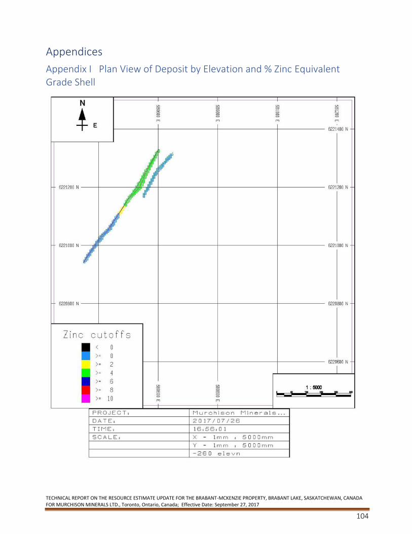
TECHNICAL REPORT ON THE RESOURCE ESTIMATE UPDATE FOR THE BRABANT-MCKENZIE PROPERTY, BRABANT LAKE, SASKATCHEWAN, CANADA FOR MURCHISON MINERALS LTD., Toronto, Ontario, Canada; Effective Date: September 27, 2017
104
Appendices
Appendix I Plan View of Deposit by Elevation and % Zinc Equivalent Grade Shell
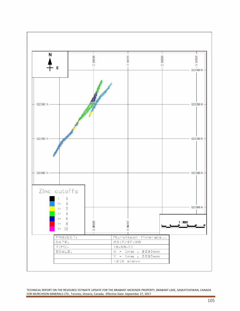
TECHNICAL REPORT ON THE RESOURCE ESTIMATE UPDATE FOR THE BRABANT-MCKENZIE PROPERTY, BRABANT LAKE, SASKATCHEWAN, CANADA FOR MURCHISON MINERALS LTD., Toronto, Ontario, Canada; Effective Date: September 27, 2017
105
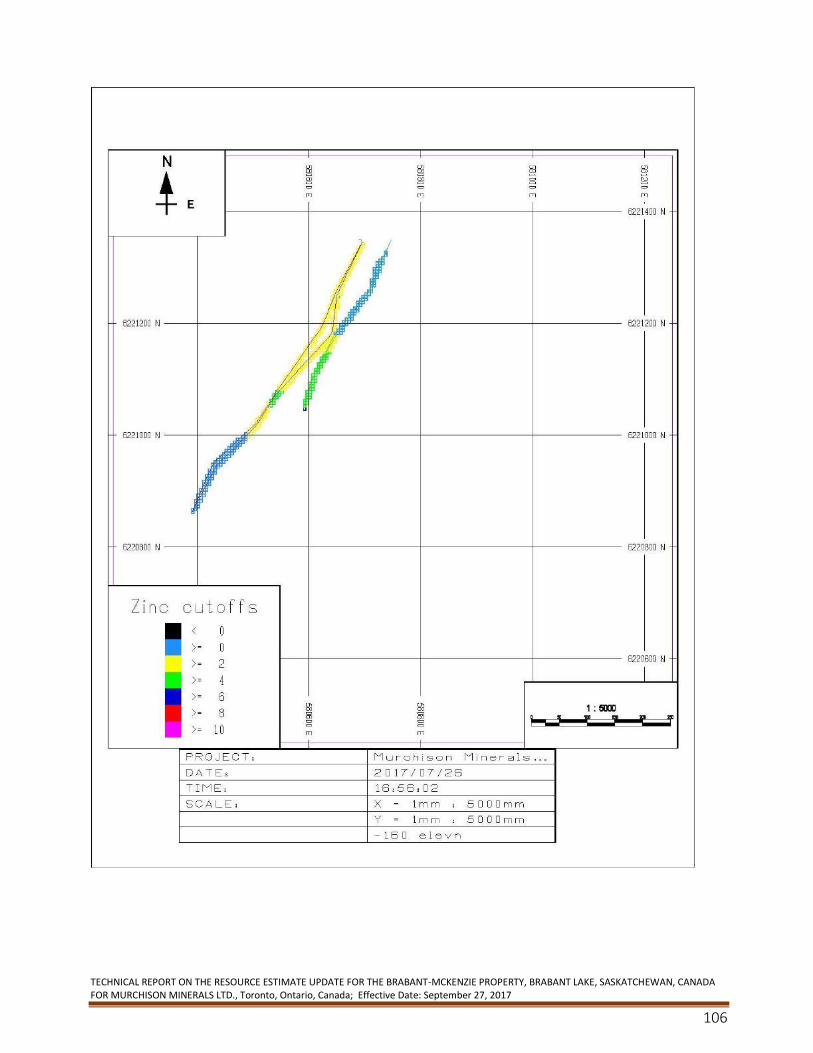
TECHNICAL REPORT ON THE RESOURCE ESTIMATE UPDATE FOR THE BRABANT-MCKENZIE PROPERTY, BRABANT LAKE, SASKATCHEWAN, CANADA FOR MURCHISON MINERALS LTD., Toronto, Ontario, Canada; Effective Date: September 27, 2017
106
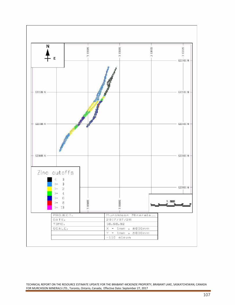
TECHNICAL REPORT ON THE RESOURCE ESTIMATE UPDATE FOR THE BRABANT-MCKENZIE PROPERTY, BRABANT LAKE, SASKATCHEWAN, CANADA FOR MURCHISON MINERALS LTD., Toronto, Ontario, Canada; Effective Date: September 27, 2017
107
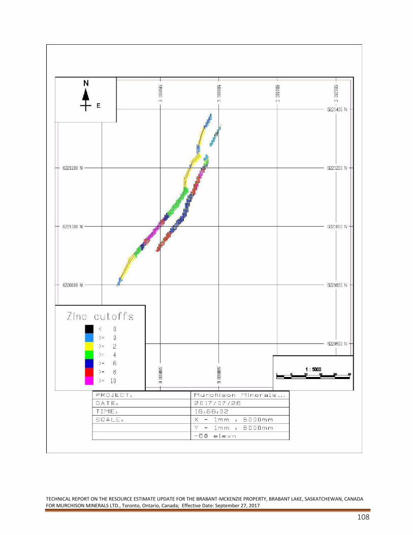
TECHNICAL REPORT ON THE RESOURCE ESTIMATE UPDATE FOR THE BRABANT-MCKENZIE PROPERTY, BRABANT LAKE, SASKATCHEWAN, CANADA FOR MURCHISON MINERALS LTD., Toronto, Ontario, Canada; Effective Date: September 27, 2017
108
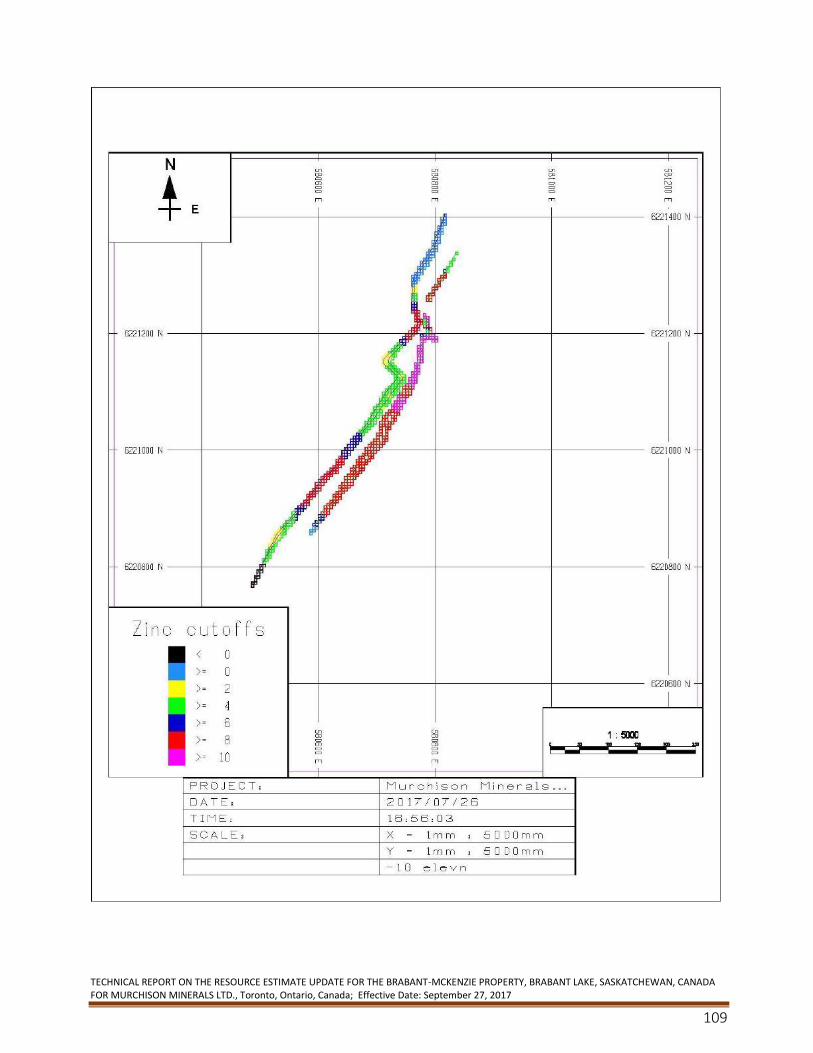
TECHNICAL REPORT ON THE RESOURCE ESTIMATE UPDATE FOR THE BRABANT-MCKENZIE PROPERTY, BRABANT LAKE, SASKATCHEWAN, CANADA FOR MURCHISON MINERALS LTD., Toronto, Ontario, Canada; Effective Date: September 27, 2017
109
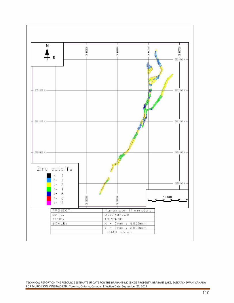
TECHNICAL REPORT ON THE RESOURCE ESTIMATE UPDATE FOR THE BRABANT-MCKENZIE PROPERTY, BRABANT LAKE, SASKATCHEWAN, CANADA FOR MURCHISON MINERALS LTD., Toronto, Ontario, Canada; Effective Date: September 27, 2017
110
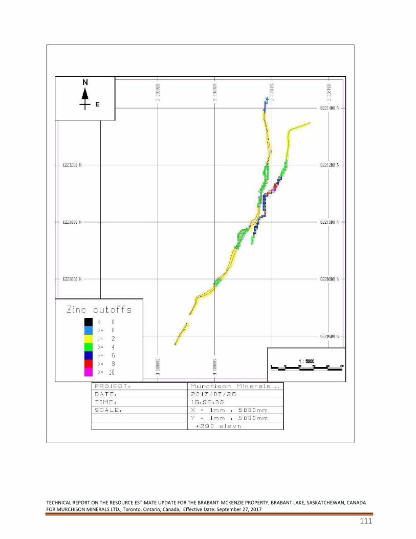
TECHNICAL REPORT ON THE RESOURCE ESTIMATE UPDATE FOR THE BRABANT-MCKENZIE PROPERTY, BRABANT LAKE, SASKATCHEWAN, CANADA FOR MURCHISON MINERALS LTD., Toronto, Ontario, Canada; Effective Date: September 27, 2017
111
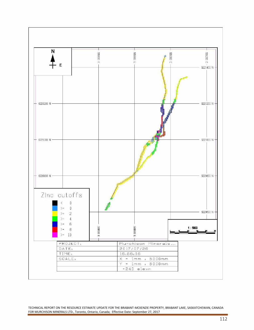
TECHNICAL REPORT ON THE RESOURCE ESTIMATE UPDATE FOR THE BRABANT-MCKENZIE PROPERTY, BRABANT LAKE, SASKATCHEWAN, CANADA FOR MURCHISON MINERALS LTD., Toronto, Ontario, Canada; Effective Date: September 27, 2017
112
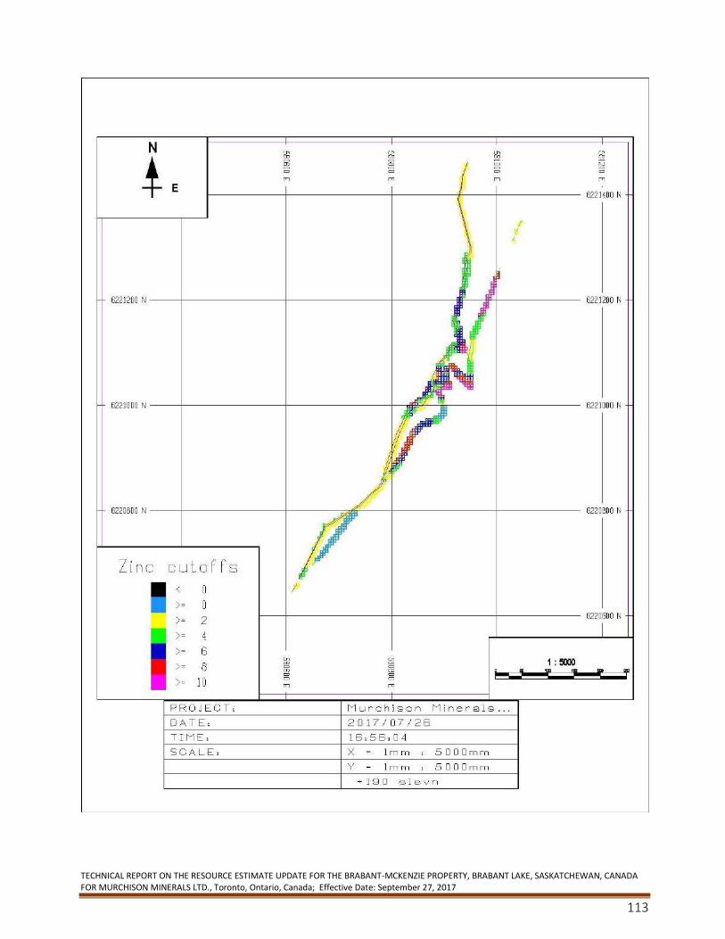
TECHNICAL REPORT ON THE RESOURCE ESTIMATE UPDATE FOR THE BRABANT-MCKENZIE PROPERTY, BRABANT LAKE, SASKATCHEWAN, CANADA FOR MURCHISON MINERALS LTD., Toronto, Ontario, Canada; Effective Date: September 27, 2017
113
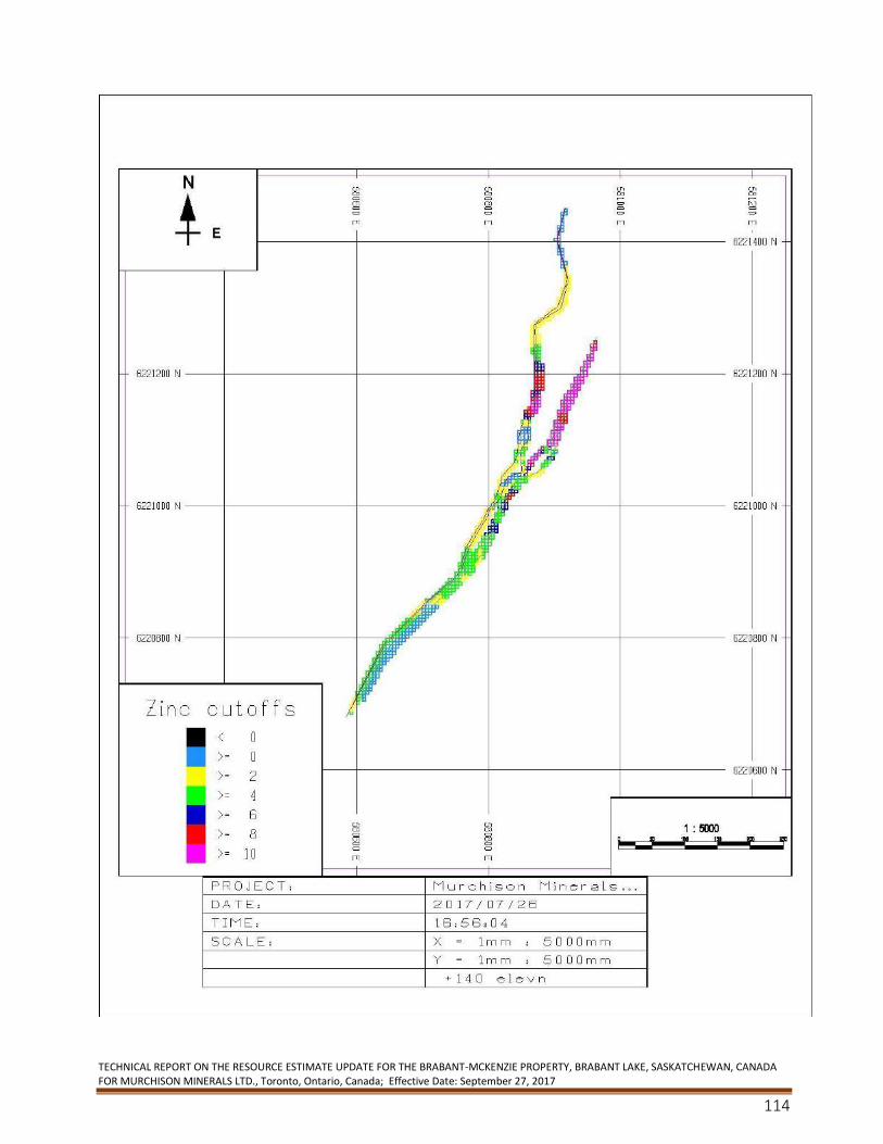
TECHNICAL REPORT ON THE RESOURCE ESTIMATE UPDATE FOR THE BRABANT-MCKENZIE PROPERTY, BRABANT LAKE, SASKATCHEWAN, CANADA FOR MURCHISON MINERALS LTD., Toronto, Ontario, Canada; Effective Date: September 27, 2017
114
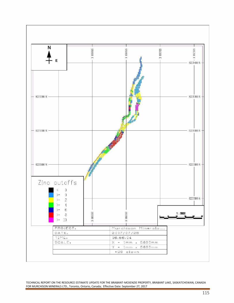
TECHNICAL REPORT ON THE RESOURCE ESTIMATE UPDATE FOR THE BRABANT-MCKENZIE PROPERTY, BRABANT LAKE, SASKATCHEWAN, CANADA FOR MURCHISON MINERALS LTD., Toronto, Ontario, Canada; Effective Date: September 27, 2017
115
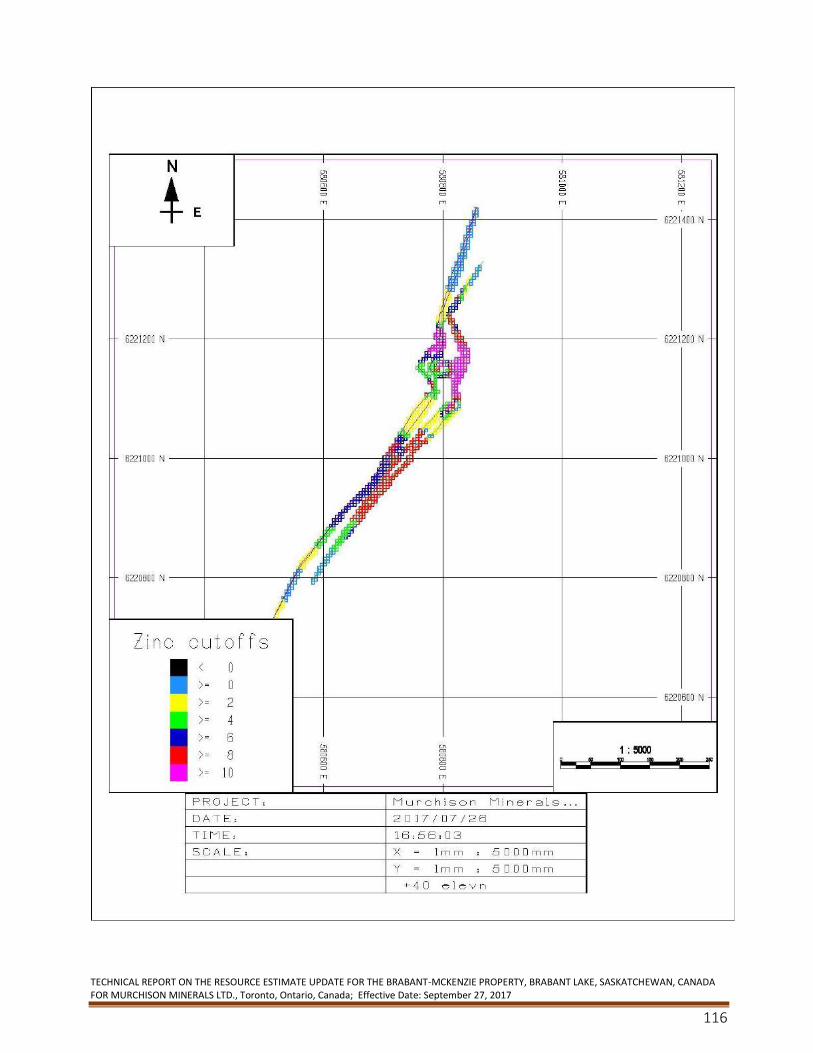
TECHNICAL REPORT ON THE RESOURCE ESTIMATE UPDATE FOR THE BRABANT-MCKENZIE PROPERTY, BRABANT LAKE, SASKATCHEWAN, CANADA FOR MURCHISON MINERALS LTD., Toronto, Ontario, Canada; Effective Date: September 27, 2017
116
CONSENT of QUALIFIED PERSON
I, Finley Bakker, consent to the public filing of the technical report titled “TECHNICAL REPORT ON THE RESOURCE ESTIMATE UPDATE FOR THE BRABANT-MCKENZIE PROPERTY, BRABANT LAKE, SASKATCHEWAN, CANADA FOR MURCHISON MINERALS LTD.” and dated November 25, 2017 (the "Technical Report") filed by Murchison Minerals Ltd.
Dated this March 11, 2018
“Finley Bakker”
Finley Bakker, P. Geo