technical report for the - condor resources inc · here to milpo’s cerro lindo mine. this road is...
TRANSCRIPT

TECHNICAL REPORT FOR THE PUCAMAYO GOLD-SILVER PROPERTY, CORDILLERA OCCIDENTAL, PERU FOR: CONDOR RESOURCES INC. BY: Richard Culbert, Ph.D., P.Eng. Dated: June, 2010

TABLE OF CONTENTS Page Summary 3 Introduction and Terms of Reference 3 Disclaimer 4 Property Description and Location 4 Accessibility, Climate, Local Resources, Infrastructure and Physiography 5 History 6 Geological Setting 5 Deposit Types 6 Mineralization 9 Exploration 9
Geophysical Surveys 9 Drilling 10 Sampling Method and Approach 15 Sample Preparation, Analyses and Security 15 Data Verification 15 Adjacent Properties 17 Interpretation and Conclusions 17 Recommendations 17 Cost Estimates 17 Certificate 19 FIGURES Figure 1: Property Location Map 4 Figure 2: Claims map 5 Figure 3: East Zone Lithology 7 Figure 4: West Zone Lithology 8 Figure 5: East Zone, Chargeability, 50 m. 22 Figure 6: East Zone, Chargeability, 200 m. 22 Figure 7: East Zone, Resistivity, 100 m. 23 Figure 8: East Zone, Geophysical Section, line 0N 24 Figure 9: East Zone, Geophysical Section, line 600N 24 Figure 10: East Zone, Geophysical Anomalies 25 Figure 11: West Zone, Chargeability, 100 m. 26 Figure 12: West Zone, Resistivity, 100 m. 26 Figure 13: East Zone, Sample Results for Gold 11 Figure 14: East Zone, Sample Results for Silver 12 Figure 15: West Zone, Sample Results for Gold 13 Figure 16: West Zone, Sample Results for Silver 14
2

page APPENDICES Appendix I Geophysical Result 21 Figures 5 to 12 Appendix II Photographs 27 SUMMARY The Pucamayo Property is located on a rolling plateau at 4000 meters altitude in the mountains southeast of Lima, Peru. Condor Resources Inc. have optioned these claims from Back Arc Minerals S.A., a Peruvian company, and have carried out extensive sampling, mapping and geophysical surveys over epithermal alteration zones in the Eastern and Western sectors of the elongated, forty two square kilometre claim block. Despite limited outcrop, sampling of siliceous breccias exposed along structures has yielded significant gold and silver values, and the induced polarization data suggest that the visible outcrops are part of much larger epithermal systems, especially in the Eastern Zone. The author spent three days in the area, check sampling and examining the geology, and verified both the tenor of precious metals and the nature of the epithermal zones, which appear to vary from high to low sulfidization. In view of the attractive precious metal assays and geophysical results, a program of up to 3000 meters of diamond drilling is recommended to test the various geochemical, geophysical and geological targets on this property. The estimated cost if the full program is completed comes to $616,000 in U.S. dollars. INTRODUCTION AND TERMS OF REFERENCE This report has been written at the request of Mr. Patrick Burns, President of Condor Resources Incorporated. It is based on a three day visit to the Pucamayo property in the high Cordillera to southeast of Lima, Peru. The visit and the report are to independently verify the tenor of the gold and silver values being reported by Condor Resouces, and to comment on the models of the Pucamayo deposits being developed.
3
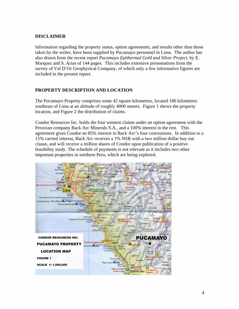
DISCLAIMER Information regarding the property status, option agreements, and results other than those taken by the writer, have been supplied by Pucamayo personnel in Lima. The author has also drawn from the recent report Pucamayo Epithermal Gold and Silver Project, by E. Marquez and S. Arias of 144 pages. This includes extensive presentations from the survey of Val D’Or Geophysical Company, of which only a few informative figures are included in the present report. PROPERTY DESCRIPTION AND LOCATION The Pucamayo Property comprises some 42 square kilometres, located 180 kilometres southeast of Lima at an altitude of roughly 4000 meters. Figure 1 shows the property location, and Figure 2 the distribution of claims. Condor Resources Inc. holds the four western claims under an option agreement with the Peruvian company Back Arc Minerals S.A., and a 100% interest in the rest. This agreement gives Condor an 85% interest in Back Arc’s four concessions. In addition to a 15% carried interest, Back Arc receives a 1% NSR with a two million dollar buy out clause, and will receive a million shares of Condor upon publication of a positive feasibility study. The schedule of payments is not relevant as it includes two other important properties in northern Peru, which are being explored.
4

ACCESSIBILITY, CLIMATE, LOCAL RESOURCES, INFRASTRUCTURE AND PHYSIOGRAPHY To date, exploration of the Pucamayo Property has largely been based from the small mountain town of Chavin. This is reached from kilometre 180 on the Panamerican Highway (soon to be replaced) south of Lima. An excellent haulage road climbs from here to Milpo’s Cerro Lindo Mine. This road is controlled, but traffic to Chavin is allowed to pass. After approximately 60 km., the road to Chavin branches, and it is another hours drive to the town. From here the western showings can be reached in about 20 minutes with a 4x4 vehicle. The eastern showings are only 33 km. from Chavin, but this can take well over an hour due to difficult driving, and it is planned to bring the drill in via another access from the coastal town of Cañete. It is also possible that for detailed work on the eastern showings, the base will be moved to the closer town of Liscay. The western flank of the Cordillera Occidental is deeply incised by valleys, but the upper parts of the range tend to be open and surprisingly gentle in topography, with the property at roughly 4000 meters elevation. Small villages are widely scattered in the region. Being well above timberline, the only present use of the uplands is sparse grazing by
5

sheep, goats and cattle. The only large wild animal noted was the vicuña, a deer-like cameloid, which are hunted by the local people. Although the adjacent coast of Peru is an extreme desert, there is substantial rainfall in the upper reaches of the Cordillera Occidental, mainly as the result of thunderstorms. El Niño years can be especially wet. Other than food, water and man-power, local resources are scant and infrastructure primitive. HISTORY Most of the territory surrounding the Pucamayo Property has now by staked by other interests. Geologix Inc. and other companies are known to have examined the general region, and one drill hole was apparently made farther north. GEOLOGICAL SETTING In the regional setting, Lower Cretaceous sediments are overlain by island arc andesites, which host the nearby Cerro Lindo volcanic massive sulfide deposit. These have been invaded by an intrusive complex known as the coastal batholith, with both Cretaceous and Tertiary units. Overlying these are Pliocene-Pleistocene tuffs and flows of acid composition related to a nearby volcanic center. This is part of a Tertiary volcanic belt which hosts major gold-silver deposits in Peru, such as Yanachocha, Pierina and Alto Chicama. In the vicinity of the property, rhyodacitic tuffs overly both pre-mineralization andesites and granitic rocks. The precious metals are hosted in epithermal systems related to this relatively recent phase of volcanism. The deposits are controlled both by northwest trending fractures (which dominate the Cordillera) and by northeast trending cross-fractures. It is likely that the interaction of these two systems produced sites of dilation, which assisted emplacement of epithermal materials. Outcrop exposure is somewhat erratic due to widespread glacio-fluvial and other detritus. Some of the more competent quartz veins are exposed by differential weathering, but the geophysical data suggest that the systems are larger, undoubtedly involving argillic alteration zones and other complexities.
6

7

DEPOSIT TYPES Two areas, on the east and west sides of the property have been examined in some detail, involving mapping, sampling and geophysics. There are also some epithermal occurrences between, but these are less well exposed or studied to date. The Eastern Zone is dominated by a wide and complex band of epithermal silicification which can be traced from the property border for some 300 meters, and in reduced form well beyond. The width is difficult to estimate due to overburden. These exposed siliceous sectors present a multiphase, high sulphidization system, with quartz ranging from vuggy and drusy to chalcedonous, and a wide variety of breccias. Argillic materials found with the silica include alunite and dickite, and although poorly exposed, the occurrence appears to be surrounded by extensive zones of alteration. Vents of granular silica typical of steam eruptions are found on higher ground to the east. This, and the geophysical data, suggest that the zone of epithermal influence is extensive.
8

The Western Zone displays what appear to be classical low to medium sulfidization quartz veins, with varying widths and with textures indicating at least two phases of emplacement. The argillic alteration zones which usually accompany such epithermal systems are not exposed, but geophysical evidence suggests that they are part of a larger system. MINERALIZATION The form in which the precious metals occur has not yet been determined. Several outcrops in which the sulfides have not been oxidized show copper, lead and zinc mineralization. Gold, however, shows no correlation with any of the other elements, including silver. Copper, lead and zinc are strongly inter-correlated and clearly form an association or a ‘mineralization factor’. They are moderately correlated with silver and with the epithermal elements such as arsenic and antimony. It is possible that gold was precipitated and controlled by boiling levels and has little relationship to sulfides. Some samples were sent by Condor Resources for Terraspec analysis, a method used to identify clays and other alteration products. The results showed considerable amounts of the mineral dickite in a few cases, which is usually considered a high temperature form of kaolin. Other assemblages suggested lower temperature origins, however. This again points to a complex, multiphase epithermal history. EXPLORATION Gold and silver sampling and results are shown in Figures 13 and 14 respectively for Pucamayo East and in Figures 15 and 16 for Pucamayo West. Values are erratic, as is the nature of precious metals in epithermal zones. It should be recalled that exposure is not good for much of this area, and as a rule if anything outcrops it is likely to be the most silicified materials. For a broader look at the epithermal systems involved, geophysics provides some guidance. Geophysical Surveys Scintillometer, magnetometer and induced polarization (I.P.) surveys were carried out over grids covering sites of interest in both the eastern and western parts of the property. Little in the way of structure appeared from the radioactivity data, although both potassium and thorium appeared to be depleted over the large alteration zone in Pucamayo East. Magnetic intensity was likely controlled by the chemistry of the tuff layers and subsequent weathering or destruction of any magnetite. There were, however, thin, enigmatic magnetic lines flanking the above-mentioned alteration zone in a northwesterly direction. The most valuable information came from the I.P. work, and selected diagrams (figures 5 to 12) are presented to show various features. These have been placed in Appendix 1, to avoid disruption of the written report.
9

Turning first to the high sulfidization epithermal zone of Pucamayo East, the primary surface feature is an elongated exposure of vuggy, multiphase quartz breccias with minor disseminated sulfides and pockets of clay minerals, including alunite. It is not clear whether this mixture would be anomalous in either chargeability (low for quartz vs. high for sulfides and clays), or in resistivity (high for quartz vs. low for wet clays, oxides). Indeed, this breccia was almost invisible to the I.P., but some very strong anomalies did present themselves, especially in chargeablity. Figure 5 shows chargeability at 50 meters depth, and Figure 6 at 200 meters. The most riveting feature is a very strong, nearly circular high. This extends to at least 300 meters depth (Figure 9) and has a diameter of roughly half a kilometre. It may be some sort of pipe or diatreme, but it is almost certainly the deep plumbing for this epithermally altered region, and should be explored by drilling. At 200 meters depth, the chargeability shows an axis extending to the southeast, flanking the esposed breccia band. At greater depths, the feature develops an intriguing northeast-trending cross-structure with high chargeability and high resistivity. Compared to chargeability, the resistivity data is not very informative. The map for 100 meters depth (Figure 7) shows a weak low axis through the chargeability high, but the effect is diluted by an undefined region of low resistivity to the east. What is clear and somewhat mysterious is that everywhere the resistivity increases with depth, even under the above-described circular anomaly (Figure 9), where chargeability continues downward. This might be due to increasing silicification or to passing below the level of ground water and weathering. Turning now to Pucamayo West, Figure 11 shows chargeability at 100 meters depth. The main vein trend hardly shows up at all, which is perhaps not surprising considering that the gold and silver values here are not accompanied by much sulphides. There is a strong response from the northeast trending cross-structure, but this is based only on the two lines that cross it. The projected junction of these two structures might be an interesting drill target. On the resistivity diagram for the same depth (Figure 12), the main trend shows up as parallel high and low anomalies. This is what might be expected if this is a siliceous system flanked by argillic alteration, which is common in epithermal veining. In that case, the system is considerably wider than the poorly exposed quartz outcrops would indicate. DRILLING There has been no drilling on the property to date, but as the sampling, mapping and geophysics have outlined several attractive targets, a program is recommended.
10

11

12

13

14

SAMPLING METHOD AND APPROACH Sampling by workers of Condor Resources has relied mainly on taking “chip channels” across the limited exposures of silicified or otherwise altered structures. The check-samples taken by the author were of a similar nature. Later work by Condor has relied on a rock saw to take more representative channels. SAMPLE PREPARATION, ANALYSES AND SECURITY Samples taken by the author were placed in plastic bags and sealed with security straps. They were delivered to ALS Chemex Laboratories is San Isidro, Lima. This is a well known and respected analytical laboratory, fully ISO certified. Samples were dried, crushed, split and pulverized. For gold, a 30 gram sample was fire assayed with an atomic absorption finish. Silver and other elements were measured by induction coupled plasma – mass spectronomy following an aqua regia leach. DATA VERIFICATION Seven samples were taken by the author at Pucamayo West and seven at Pucamayo East to verify the general tenor of assays being reported by Condor Resources from this property. Results for gold and silver are shown in the following table, compared to those from nearby samples taken by Condor. Three samples attempted to replicate erratically high (over 5 ppm) gold results from the many previously taken, and these returned values more typical of the others in their structure. It hence appears that these were not highly anomalous locations, but simply sampling outliers typical of gold distribution. Otherwise, the results for both gold and silver confirm company reports. In the following table, PMW (Pucamayo West) and PME (Pucamayo East) samples by the author are followed by adjacent samples sites reported by Condor Resources.
15

16

ADJACENT PROPERTIES Although the surrounding terrain has been staked by other interests, and although similar Tertiary volcanic centers have hosted major precious metal deposits in the Cordillera Occidental of Peru, the only known mineral deposit of importance in the immediate vicinity is the Cerro Lindo Mine, a volcanic massive sulfide deposit unrelated to the Pucamayo mineralization. INTERPRETATION AND CONCLUSIONS The sampling, mapping and geophysical surveys have outline a complex, poorly-exposed geothermal system with the size and with the levels of precious metals to be an economically attractive drill target. RECOMMENDATIONS Little more can be done to define drill targets on the showings explored to date, and drilling is clearly indicated, following completion of permit agreements with the adjacent communities. The cost estimations envision a program with a maximum of 3000 meters diamond drilling, lasting three months. In view of the uncertainties, the spotting of all holes in advance is not advised, as the strategy is expected to evolve as the targets are drilled and the core logged. It is assumed that the geologist and assistant geologist presently employed by Condor Resources in Peru will be involved in this project. Their wages, along with the ongoing overhead of the Lima office, accounting and any visits by other Condor personnel have not been included in the following estimates. Cost Estimates ($U.S.) Drilling 306,000.00 Mobilization/demobilization 7,500.00 2000 gallon water tank 12,500.00 Bulldozer for access, platforms etc. 30,000.00 Core boxes, sample bags, storage etc. 18,000.00 Additional field assistants (wages) 27,000.00 Food and local lodging 15,000.00 Field equipment (tents, medicine, saw blades, sat. phone etc.) 17,000.00 Transportation and fuel 9,000.00 Sample analyses 65,000.00 Community permits, assistance 25,000.00 Drafting, reports, environmental permit 13,000.00 Insurance, taxes 5,000.00
17

Subtotal 550,000.00 12% contingency 66,000.00 Total estimated cost $616,000.00
18

RICHARD CULBERT; Ph. D., P. Eng. MINING EXPLORATION CONSULTANT P.O. Box 9, Gibsons B.C. Canada, V0N1V0 Ph 604 886 0919 FAX 604 886 9236 [email protected] CERTIFICATE OF AUTHOR I, Richard Culbert; Ph.D., P.Eng. do hereby certify that:
1. I am a private consultant, with office address as above.
2. I graduated with a degree in Geological Engineering from The University of British Columbia in 1963, and I obtained a doctorate from the Department of Geophysics from the same university in 1970.
3. I am a member of the Association of Professional Engineers and Geoscientists of British Columbia.
4. I have worked as a geologist for a total of 40 years since my graduation from university.
5. I have read the definition of “qualified person” set out in National Instrument 43-101 (“NI-43-101”) and certify that by reason of my education, affiliation with a professional association (as defined in NI 43-101) and past relevant work experience, I fulfill the require- ments to be a “qualified person” for the purposes of NI 43-101.
6. I am responsible for the preparation of all sections of the technical report titled: Technical Report for the Pucamayo Gold-Silver Property, Cordillera Occidental, Peru and dated June, 2010, relating to the Pucamayo Property, (the “Technical Report”). I visited the Pucamayo Property in March of 2010 for three days.
7. I had once visited the Pucamayo property two years earlier.
8. I am not aware of any material fact or material change with respect to the subject matter of the Technical Report that is not reflected in the Technical Report, the omission to disclose which makes the Technical
19

Report misleading.
9. I am independent of the issuer applying all of the tests in section 1.5 of National Instrument 43-101.
10. I have read National Instrument 43-101 and form 43-101F1, and the Technical Report has been prepared in compliance with that instrument and form.
10. I consent to the filing of the Technical Report with any stock exchange and other regulatory authority and any publication by them for regulatory purposes, including electronic publication in the public company files on their websites accessible by the public, of the Technical Report.
Dated: June 20, 2010.
20

APPENDIX I GEOPHYSICAL DIAGRAMS
21

22

23

24

25

26

APPENDIX II PHOTOGRAPHS
27

28

29

30

31