technical report 8: cia ngati te ata waiohua
TRANSCRIPT


This report takes into account the particular instructions and requirements of our client. It is not intended for and should not be relied upon by any third party and no responsibility is undertaken to any third party. The cultural information in this report is the intellectual property of Ngati Te Ata Waiohua Iwi Authority.
MATUKUTUREIA
PRELIMINARY CULTURAL IMPACT ASSESSMENT
FOR
McLaughlins Quarry Private Plan Change
PREPARED FOR
EUROCLASS SERVICES LTD
PREPARED BY
NGATI TE ATA WAIOHUA
APRIL 2019

2 8 April 2019
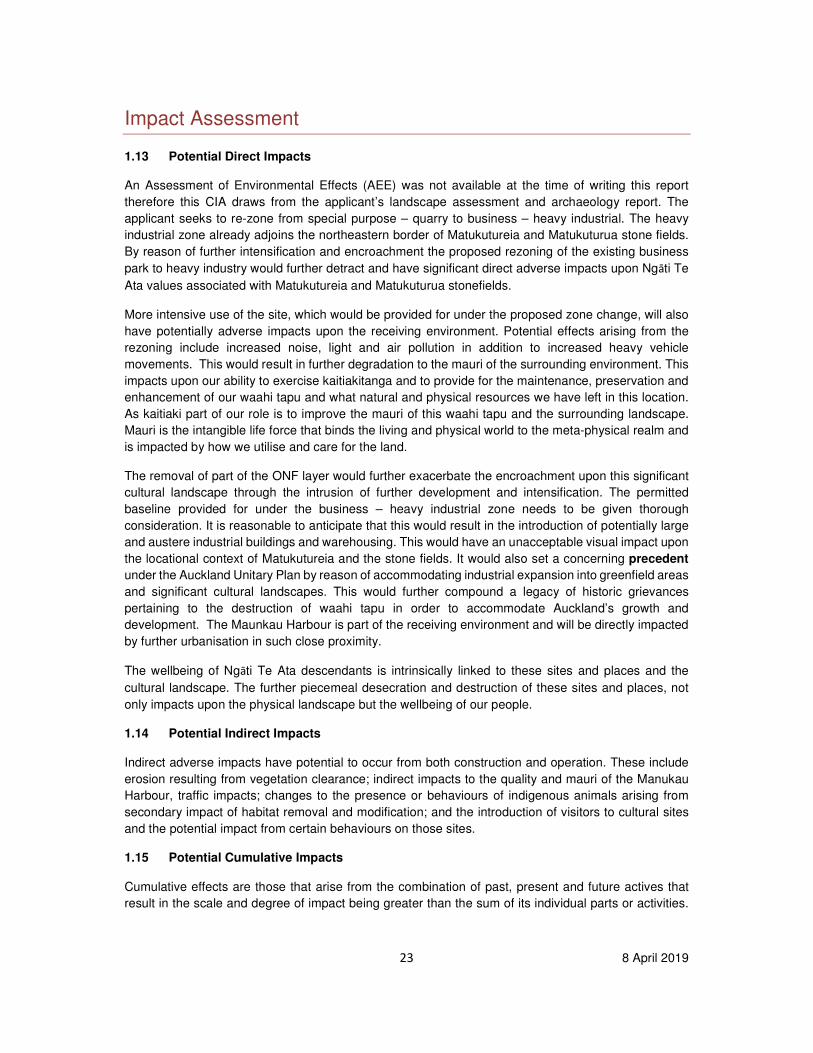
Found in situ Matukutureia stonefields,
the upright stones (pou-paenga) which served as traditional boundary markers

3 8 April 2019
WHAKATAUAKI
Whakatauaki; Taonga Tuku Iho
He wāhi hirahira, he hangānga, me nga rakau o te ngahere kei tenei rohe. He nui te mana o nga taonga
nei; ahakoa he mana tikanga, mana wairua, mana korero tuturu, mana mahi huakanga ranei.
Whakanuia, tiakina hoki te whanuitanga me te mana motuhake o nga taonga tuku iho, hei painga mo
nga tamariki, mokopuna, o nga ra kei te haere mai.
Proverb: Treasures Passed Down
There are special sites, places, structures and trees which are treasured by us as a heritage passed
into our care. Let us be good caretakers of our diverse and unique heritage that we in turn may pass it
on to the care of future generations.
4 8 April 2019
CONTENTS
Introduction 5
1.1 Project Background 5
1.2 Site Description 5
1.3 Aims and Objectives 7
Methodology 8
1.4 Statutory Context 8
1.5 Planning Policy Context 9
1.6 Scoping and Consultation 12
1.7 Assessment Approach 13
1.8 Assumptions and Limitations 14
Environmental Baseline 15
1.9 Topography and Geology 15
1.10 Natural Resources and Ecology
Error! Bookmark not defined.
Cultural Baseline 15
1.11 Statement of Association 15
1.12 Māori Archaeology 19
1.13 Cultural Sites and Resources 21
Impact Assessment 23
1.14 Potential Direct Impacts 23
1.15 Potential Indirect Impacts 23
1.16 Potential Cumulative Impacts 23
1.17 Summary of Effects 25
Conclusion 26
Recommendations 27
References
5 8 April 2019
INTRODUCTION 1.1 Project Background
Te Ara Rangatu o te Iwi o Ngāti Te Ata Waiohua have been commissioned by Euroservices Limited
(hereafter the Client) to prepare a Preliminary Cultural Impact Assessment (CIA) informing a proposed private plan change request to the Auckland Unitary Plan. As part of the plan change, Euroclass Services Ltd seeks to:
• rezone the existing quarry zoning associated with the Stonehill Business Park under the AUPOP to Business - Heavy Industry,
• remove the ONF classification from the southern part of the plan change area that generally corresponds to the site at 79 McLaughlins Road.
In relation to the partial removal of the ONF, the applicant argues that the portion concerned has been
assigned the ONF classification in error and that parts of the current demarcation do not correspond
with the geological reality.
This preliminary CIA report has been prepared by Te Ara Rangatu o te Iwi o Ngāti Te Ata Waiohua as a legal entity of Ngāti Te Ata Waiohua, who are a mana whenua iwi of Tāmaki Makaurau and the upper
Waikato region. The purpose of this preliminary CIA report is to provide the Client and relevant statutory agencies with initial documentation of cultural values, interests and associations with the project area and its cultural and natural resources, and the potential high level impacts of the proposed project activities on these. This preliminary impact assessment also provides high level recommendations as to how to avoid, remedy or mitigate any potential cultural effects that arise from the project. Mana Whenua engagement in statutory processes, including provision of technical advice for impact assessments, is guided by our tikanga (customs and protocols) and framed by Te Tiriti o Waitangi, our Iwi Management Plan (IMP), and our organisational strategic values. 1.2 Site Description
The site description, as detailed by LA4 Landscape Architects, provides a succinct overview of the plan change environs and wider locational context.
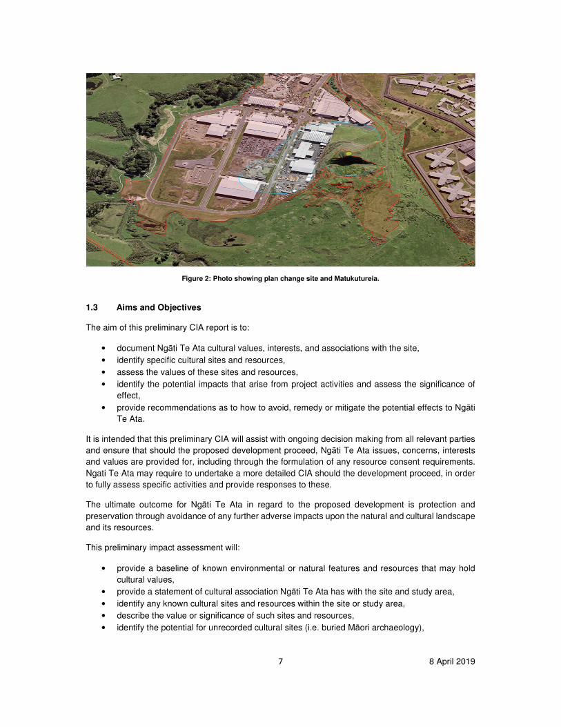
In the AUPOP ONF 93 is identified as Matukutureia (volcanic cone) and Matukuturua lava fields and tuff ring. In the wider context, these features are located between the Auckland International Airport to the west and the established urban areas of Papatoetoe, Wiri and Manurewa to the east. The local area is generally characterised by low lying, varied and gently undulating terrain located on the edge of the Manukau Harbour, and is defined by the lower reaches of the Waokauri Creek to the north and the Puhinui Creek to the south. Historically, and until relatively recent times, quarrying operations were also a significant feature of the area.1
Immediately to the west beyond the Puhinui Creek is Puhinui Reserve. Together with the lava fields (also commonly referred to as stonefields) they provide sizeable areas of public open space and a distinctive landscape scattered with archaeological remnants and natural
1 LA4 Landscape Architects, Technical Report 7: Landscape Assessment, p5

6 8 April 2019
landscape features. The most notable of which is the maunga, Matukutureia (formerly McLaughlin’s Mountain), which is a prominent local landmark. The maunga is of particular significance to Ngati Te Ata whom hold Mana Whenua status, being the birthplace of the tribe’s eponymous ancestor Te Ata Rehia. The Stonefields are one of the last significant remaining examples of pre-European Maori settlement and gardening on volcanic soils in the region.
The proposed plan change area lies immediately to the west of the Matukuturua lava field. Large scale industrial buildings and warehouses currently occupy the northern and much of the central part of the business park. The southern portion, a large part of which comprises 79 McLaughlins Road, currently remains undeveloped. In this area, the land beyond the perimeter road (Harbour Ridge Drive), is characterised by open grassland extending down to the edge of the Puhinui Creek. This land contrasts with the more hummocky terrain of the lower lava fields to the east. A natural feature of this area is a wetland located between the road and Puhinui Creek.2
Figure 1: Plan showing plan change area and wider environmental context. (Source: Clough, Technical Report 4, p2)
2 LA4 Landscape Architects, Technical Report 7: Landscape Assessment, p5
7 8 April 2019
Figure 2: Photo showing plan change site and Matukutureia.
1.3 Aims and Objectives
The aim of this preliminary CIA report is to:
• document Ngāti Te Ata cultural values, interests, and associations with the site,
• identify specific cultural sites and resources,
• assess the values of these sites and resources,
• identify the potential impacts that arise from project activities and assess the significance of
effect,
• provide recommendations as to how to avoid, remedy or mitigate the potential effects to Ngāti
Te Ata.
It is intended that this preliminary CIA will assist with ongoing decision making from all relevant parties
and ensure that should the proposed development proceed, Ngāti Te Ata issues, concerns, interests
and values are provided for, including through the formulation of any resource consent requirements.
Ngati Te Ata may require to undertake a more detailed CIA should the development proceed, in order
to fully assess specific activities and provide responses to these.
The ultimate outcome for Ngāti Te Ata in regard to the proposed development is protection and
preservation through avoidance of any further adverse impacts upon the natural and cultural landscape
and its resources.
This preliminary impact assessment will:
• provide a baseline of known environmental or natural features and resources that may hold
cultural values,
• provide a statement of cultural association Ngāti Te Ata has with the site and study area,
• identify any known cultural sites and resources within the site or study area,
• describe the value or significance of such sites and resources,
• identify the potential for unrecorded cultural sites (i.e. buried Māori archaeology),
8 8 April 2019
• identify the cultural constraints and risks associated with the Site and the potential significance
of effects,
• provide recommendations for further assessment where necessary and/or measures to avoid,
remedy or mitigate adverse effects upon Ngāti Te Ata.
METHODOLOGY 1.4 Statutory Process
Te Tiriti o Waitangi The key guiding document in any consideration of planning or practice that may impact upon the cultural values or wellbeing of Mana Whenua is Te Tiriti o Waitangi. The principles of the Treaty are recognised and provided for in the sustainable management of ancestral lands, water, air, coastal sites, wāhi tapu and other taonga, and natural and physical resources. The Treaty is articulated in law through an evolving set of principles; these include:
a) reciprocity, b) rangatiratanga, c) partnership, d) shared decision-making, e) active protection, f) mutual benefit, g) right of development, h) redress.
Heritage New Zealand Pouhere Taonga Act 2014 Statutory protection of Māori archaeology and wāhi tapu is provided for under the Heritage New Zealand Pouhere Taonga Act 2014 (HNZPTA), which is administered by Heritage New Zealand Pouhere Taonga (HNZPT), an autonomous Crown Entity. Under the Act all in situ materials, sites and features older than 1900AD are considered archaeological sites, whether previously recorded or not, and are afforded automatic protection from damage, modification or destruction without first obtaining an Archaeological Authority from HNZPT. Moveable objects and artefacts that are not in situ but that are from an archaeological context, or are of Māori origin, are controlled under the Protected Objects Act (1975). The HNZ Act S45(2)b stipulates that works on sites of interest to Māori can only occur if:
a) the practitioners can demonstrate they have the requisite competencies for recognising and respecting Māori values, and
b) the practitioners undertaking the works have access to appropriate cultural support. Under the Act Mana Whenua are enabled to provide advice or assessment regarding the management or decision taking arising from impacts to their cultural sites, provided these meet the Act’s criteria. Resource Management Act 1991 The Resource Management Act (RMA) 1991 provides statutory recognition of the Treaty of Waitangi and the principles derived from the Treaty. It introduces the Māori resource management system via the recognition of kaitiakitanga and tino Rangatiratanga, and accords Territorial Local Authorities with the power to delegate authority to iwi over relevant resource management decisions. The Act contains over 30 sections, which require Councils to consider matters of importance to tangata whenua. Some of the most important of these are:
9 8 April 2019
• The principles of the Treaty of Waitangi and their application to the management of resources
(Section 8).
• Recognition and provision for, as a matter of national importance, the relationship of Māori and
their culture and traditions with their ancestral lands, water, sites, wāhi tapu and other taonga
(Section 6(e)).
• Having particular regard to the exercise of kaitiakitanga or the iwi’s exercise of guardianship
over resources (Section 7(a)).
• Requiring the Minister for the Environment to consider input from an iwi/hapū authority when
preparing a national policy statement (Section 46).
• The ability for local authorities to transfer their functions, powers or duties under the Act to iwi
authorities (Section 33).
• Development of joint management agreements between councils and iwi/hapū authorities
(Section 36B to 36E).
• Having regard to any relevant planning document recognised by an iwi/hapū authority (sections
35A(b), 61.2A(a), 66.2A(a), 74.2A).
• The obligation to consult with iwi/hapū over consents, policies and plans (Combination of all
the sections above and Clause 3(1)(d) of Part 1 of the first schedule of the Resource
Management Act).
An assessment of impacts on cultural values and interests (CIA) can assist both applicants and the council in meeting statutory obligations in a number of ways, including:
• Preparation of an Assessment of Environmental Effects (AEE) in accordance with s88(2)(b)
and Schedule 4 of the Resource Management Act 1991 (RMA).
• Requests for further information under s92 of the RMA in order to assess the application.
• Providing information to assist the council in determining notification status under ss95 to 95F
of the RMA.
• Providing information to enable appropriate consideration of the relevant Part II matters when
making a decision on an application for resource consent under s104 of the RMA.
• Consideration of appropriate conditions of resource consent under s108 of the RMA.
Reserves Act 1977 and Conservation Act 1987 Section 4 of the Conservation Act, which is invoked by the Reserves Act, states that the Act must be interpreted and administered so as to give effect to the principles of the Treaty of Waitangi. 1.5 Planning Policy Context
National Policy Statement (NPS) for Freshwater Management 2014 The NPS for freshwater management provides national policy settings that relevant statutory agencies, including local authorities, must comply with. Policy AA1 provides for the recognition of Te Mana o Te Wai, being the connection between water and the broader environment. Policy D1 provides for the involvement of iwi/hapū in the management of fresh water and freshwater ecosystems, enabling iwi/hapū to identify cultural values and interests in fresh water and freshwater ecosystems, and reflects tangata whenua values and interests in the management of and decision-making regarding fresh water and freshwater ecosystems.
10 8 April 2019
New Zealand Coastal Policy Statement 2010 This NPS for coastal management provides national policy settings that relevant statutory agencies, including local authorities, must comply with. Policy 2 provides for the principles of Te Tiriti o Waitangi and kaitiakitanga through:
a) recognising the traditional and continuing cultural relationship with areas of the coastal environment;
b) involving tangata whenua in the preparation of regional policy statements and plans; c) with the consent of tangata whenua, incorporate mātauranga Māori in regional policy
statements, in plans and in the consideration of applications for resource consents, notices of requirement for designations, and private plan changes;
d) provide opportunities in appropriate circumstances for Māori involvement in decision making, for example when a consent application or notice of requirement is dealing with cultural localities or issues of cultural significance;
e) take into account any relevant iwi resource management plan and any other relevant planning document recognised by the appropriate iwi authority or hapū and lodged with the council;
f) provide for opportunities for tangata whenua to exercise kaitiakitanga over waters, forests, lands, and fisheries in the coastal environment; and
g) in consultation and collaboration with tangata whenua, i. recognise the importance of Māori cultural and heritage values through such methods
as historic heritage, landscape and cultural impact assessments, and ii. provide for the identification, assessment, protection and management of areas or sites
of significance or special value to Māori, and the development of methods such as alert layers and predictive methodologies for identifying areas of high potential for undiscovered Māori heritage.
Auckland Unitary Plan At a Local Government level, the Auckland Unitary Plan (AUP) provides for the protection and management of matters of importance to Mana Whenua including the environment and cultural heritage. These matters are set out in the Regional Policy Statement Chapter B6. Policy B6.2.2 provides for the recognition of Treaty of Waitangi/Te Tiriti o Waitangi partnerships and participation. This includes Policy B6.2.2(1) that provides for Mana Whenua to actively participate in the sustainable management of natural and physical resources including ancestral lands, water, sites, wāhi tapu and other taonga. Policy B6.3.2 deals with recognising Mana Whenua values and includes clause (1) that enables Mana Whenua to identify their values associated with ancestral lands, freshwater, biodiversity, and cultural heritage places and areas, and clause (2) that requires the integration of Mana Whenua values, mātauranga and tikanga in the management of natural and physical resources within the ancestral rohe. Clause (3) ensures that any assessment of environmental effects for an activity that may affect Mana Whenua values includes an appropriate assessment of adverse effects on those values. Clause (6) of the policy requires resource management decisions to have particular regard to potential impacts on: the holistic nature of the Mana Whenua world view; the exercise of kaitiakitanga; mauri; customary activities; sites and areas with significance spiritual or cultural heritage value; and any protected customary right under the Takutai Moana Act (2011). Policy B6.5.2 provides for the active protection of Mana Whenua cultural heritage. Clause (2) sets out a framework for identifying and evaluating Mana Whenua cultural heritage using the assessment factors of: mauri; wāhi tapu; kōrero tūturu; rawa tūturu; hiahiatanga tūturu; and whakaaronui o te wā. Clause (4) requires the protection of places and areas listed in Schedule 12 Sites and Places of Signifiance to Mana Whenua from adverse effects. Clause (7) provides for the inclusion of a Māori cultural assessment in structure planning and plan change processes, and clause (9) encourages appropriate design, materials and techniques for infrastructure in areas of known historic settlement and occupation.
11 8 April 2019
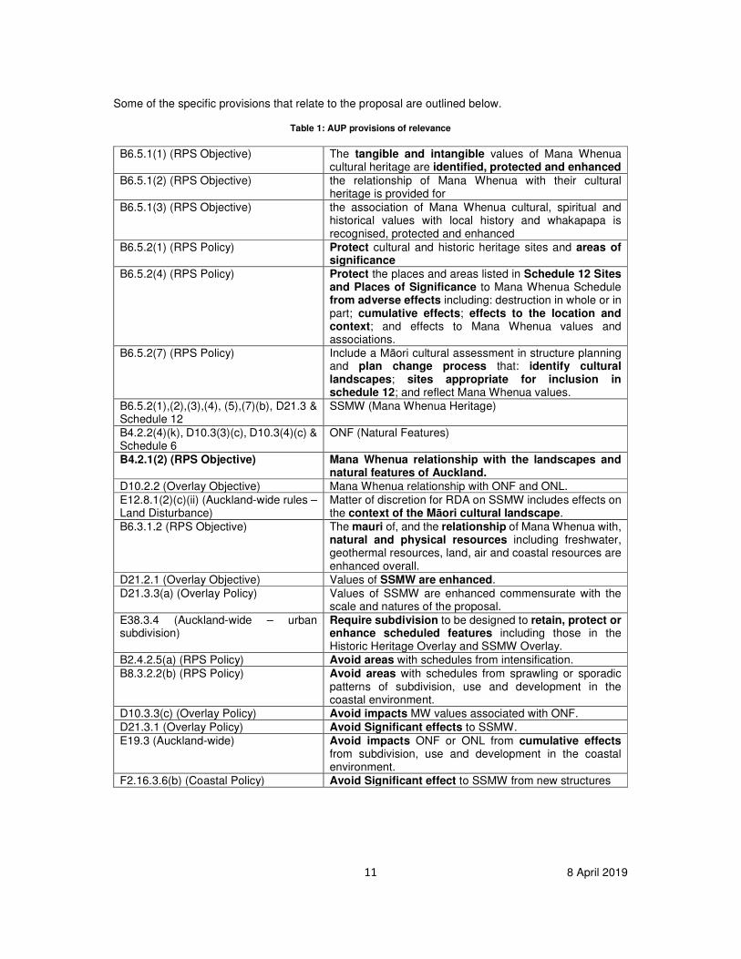
Some of the specific provisions that relate to the proposal are outlined below.
Table 1: AUP provisions of relevance
B6.5.1(1) (RPS Objective)
The tangible and intangible values of Mana Whenua cultural heritage are identified, protected and enhanced
B6.5.1(2) (RPS Objective) the relationship of Mana Whenua with their cultural heritage is provided for
B6.5.1(3) (RPS Objective) the association of Mana Whenua cultural, spiritual and historical values with local history and whakapapa is recognised, protected and enhanced
B6.5.2(1) (RPS Policy) Protect cultural and historic heritage sites and areas of significance
B6.5.2(4) (RPS Policy) Protect the places and areas listed in Schedule 12 Sites and Places of Significance to Mana Whenua Schedule from adverse effects including: destruction in whole or in part; cumulative effects; effects to the location and context; and effects to Mana Whenua values and associations.
B6.5.2(7) (RPS Policy)
Include a Māori cultural assessment in structure planning and plan change process that: identify cultural landscapes; sites appropriate for inclusion in schedule 12; and reflect Mana Whenua values.
B6.5.2(1),(2),(3),(4), (5),(7)(b), D21.3 & Schedule 12
SSMW (Mana Whenua Heritage)
B4.2.2(4)(k), D10.3(3)(c), D10.3(4)(c) & Schedule 6
ONF (Natural Features)
B4.2.1(2) (RPS Objective) Mana Whenua relationship with the landscapes and natural features of Auckland.
D10.2.2 (Overlay Objective) Mana Whenua relationship with ONF and ONL.
E12.8.1(2)(c)(ii) (Auckland-wide rules – Land Disturbance)
Matter of discretion for RDA on SSMW includes effects on the context of the Māori cultural landscape.
B6.3.1.2 (RPS Objective) The mauri of, and the relationship of Mana Whenua with, natural and physical resources including freshwater, geothermal resources, land, air and coastal resources are enhanced overall.
D21.2.1 (Overlay Objective) Values of SSMW are enhanced.
D21.3.3(a) (Overlay Policy) Values of SSMW are enhanced commensurate with the scale and natures of the proposal.
E38.3.4 (Auckland-wide – urban subdivision)
Require subdivision to be designed to retain, protect or enhance scheduled features including those in the Historic Heritage Overlay and SSMW Overlay.
B2.4.2.5(a) (RPS Policy) Avoid areas with schedules from intensification.
B8.3.2.2(b) (RPS Policy) Avoid areas with schedules from sprawling or sporadic patterns of subdivision, use and development in the coastal environment.
D10.3.3(c) (Overlay Policy) Avoid impacts MW values associated with ONF.
D21.3.1 (Overlay Policy) Avoid Significant effects to SSMW.
E19.3 (Auckland-wide) Avoid impacts ONF or ONL from cumulative effects from subdivision, use and development in the coastal environment.
F2.16.3.6(b) (Coastal Policy) Avoid Significant effect to SSMW from new structures
12 8 April 2019
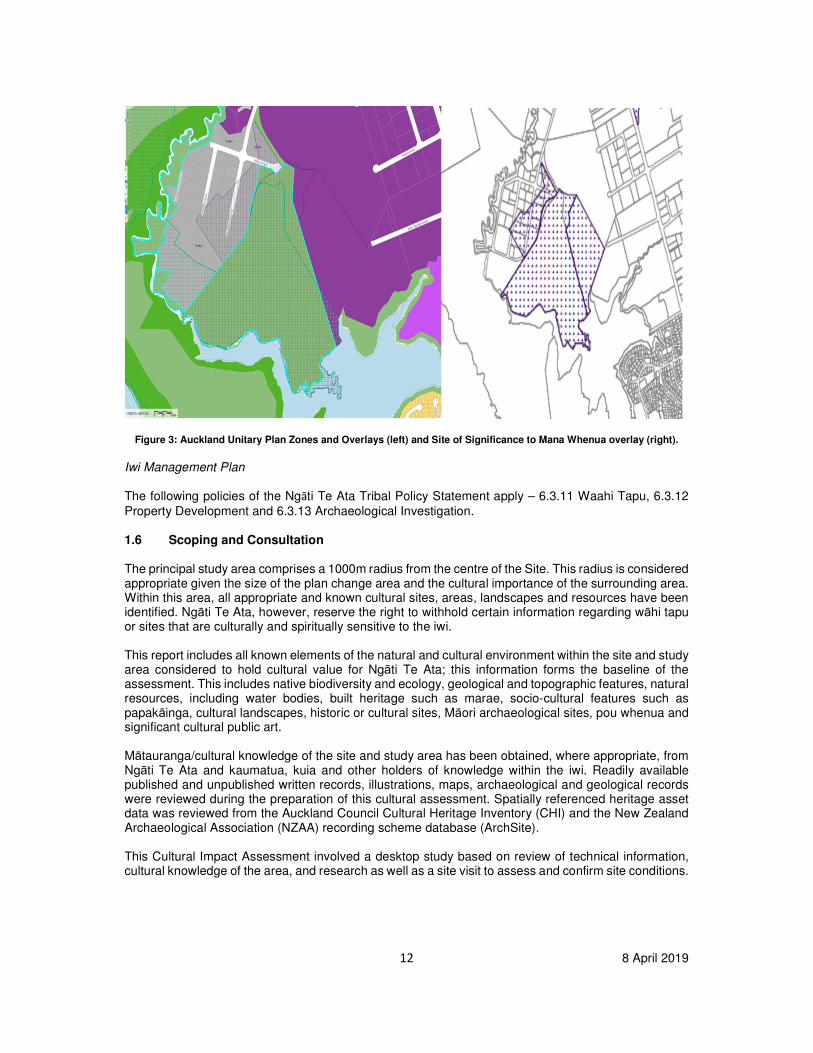
Figure 3: Auckland Unitary Plan Zones and Overlays (left) and Site of Significance to Mana Whenua overlay (right).
Iwi Management Plan The following policies of the Ngāti Te Ata Tribal Policy Statement apply – 6.3.11 Waahi Tapu, 6.3.12
Property Development and 6.3.13 Archaeological Investigation. 1.6 Scoping and Consultation
The principal study area comprises a 1000m radius from the centre of the Site. This radius is considered appropriate given the size of the plan change area and the cultural importance of the surrounding area. Within this area, all appropriate and known cultural sites, areas, landscapes and resources have been identified. Ngāti Te Ata, however, reserve the right to withhold certain information regarding wāhi tapu or sites that are culturally and spiritually sensitive to the iwi. This report includes all known elements of the natural and cultural environment within the site and study area considered to hold cultural value for Ngāti Te Ata; this information forms the baseline of the assessment. This includes native biodiversity and ecology, geological and topographic features, natural resources, including water bodies, built heritage such as marae, socio-cultural features such as papakāinga, cultural landscapes, historic or cultural sites, Māori archaeological sites, pou whenua and significant cultural public art. Mātauranga/cultural knowledge of the site and study area has been obtained, where appropriate, from Ngāti Te Ata and kaumatua, kuia and other holders of knowledge within the iwi. Readily available published and unpublished written records, illustrations, maps, archaeological and geological records were reviewed during the preparation of this cultural assessment. Spatially referenced heritage asset data was reviewed from the Auckland Council Cultural Heritage Inventory (CHI) and the New Zealand Archaeological Association (NZAA) recording scheme database (ArchSite). This Cultural Impact Assessment involved a desktop study based on review of technical information, cultural knowledge of the area, and research as well as a site visit to assess and confirm site conditions.
13 8 April 2019
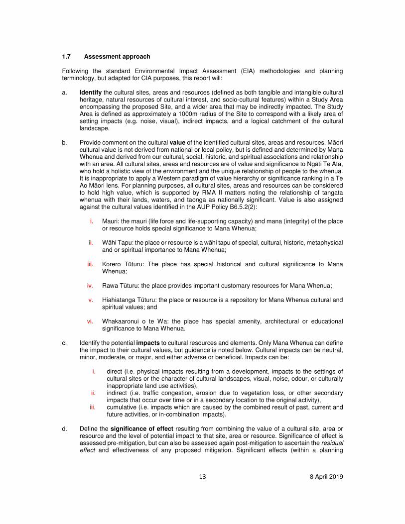
1.7 Assessment approach
Following the standard Environmental Impact Assessment (EIA) methodologies and planning terminology, but adapted for CIA purposes, this report will: a. Identify the cultural sites, areas and resources (defined as both tangible and intangible cultural
heritage, natural resources of cultural interest, and socio-cultural features) within a Study Area encompassing the proposed Site, and a wider area that may be indirectly impacted. The Study Area is defined as approximately a 1000m radius of the Site to correspond with a likely area of setting impacts (e.g. noise, visual), indirect impacts, and a logical catchment of the cultural landscape.
b. Provide comment on the cultural value of the identified cultural sites, areas and resources. Māori
cultural value is not derived from national or local policy, but is defined and determined by Mana Whenua and derived from our cultural, social, historic, and spiritual associations and relationship with an area. All cultural sites, areas and resources are of value and significance to Ngāti Te Ata, who hold a holistic view of the environment and the unique relationship of people to the whenua. It is inappropriate to apply a Western paradigm of value hierarchy or significance ranking in a Te Ao Māori lens. For planning purposes, all cultural sites, areas and resources can be considered to hold high value, which is supported by RMA II matters noting the relationship of tangata whenua with their lands, waters, and taonga as nationally significant. Value is also assigned against the cultural values identified in the AUP Policy B6.5.2(2):
i. Mauri: the mauri (life force and life-supporting capacity) and mana (integrity) of the place or resource holds special significance to Mana Whenua;
ii. Wāhi Tapu: the place or resource is a wāhi tapu of special, cultural, historic, metaphysical and or spiritual importance to Mana Whenua;
iii. Korero Tūturu: The place has special historical and cultural significance to Mana
Whenua;
iv. Rawa Tūturu: the place provides important customary resources for Mana Whenua;
v. Hiahiatanga Tūturu: the place or resource is a repository for Mana Whenua cultural and spiritual values; and
vi. Whakaaronui o te Wa: the place has special amenity, architectural or educational
significance to Mana Whenua. c. Identify the potential impacts to cultural resources and elements. Only Mana Whenua can define
the impact to their cultural values, but guidance is noted below. Cultural impacts can be neutral, minor, moderate, or major, and either adverse or beneficial. Impacts can be:
i. direct (i.e. physical impacts resulting from a development, impacts to the settings of cultural sites or the character of cultural landscapes, visual, noise, odour, or culturally inappropriate land use activities),
ii. indirect (i.e. traffic congestion, erosion due to vegetation loss, or other secondary impacts that occur over time or in a secondary location to the original activity),
iii. cumulative (i.e. impacts which are caused by the combined result of past, current and future activities, or in-combination impacts).
d. Define the significance of effect resulting from combining the value of a cultural site, area or resource and the level of potential impact to that site, area or resource. Significance of effect is assessed pre-mitigation, but can also be assessed again post-mitigation to ascertain the residual effect and effectiveness of any proposed mitigation. Significant effects (within a planning
14 8 April 2019
framework) are those with moderate or large effects (either adverse or beneficial). This method is outlined below in Table 1.
Table 2: Significance of effect
LEVEL OF IMPACT
No Change Minor Moderate Major
CU
LT
UR
AL V
ALU
E Hig
h Neutral Moderate Large Large
Me
diu
m
N/A N/A N/A N/A
Low
N/A N/A N/A N/A
1.8 Assumptions and limitations
Ngāti Te Ata are the experts of their own culture and tikanga. Through a necessity to work within a
western planning framework, we utilise planning language where possible to aid in mutual
understanding, however, there is difficulty in the translation and application of some core cultural
concepts to such a framework. This is particularly challenging when segmenting or demarcating value
spatially, when ascribing a type of significance hierarchy, and when limiting value to tangible elements
(whereas Māori hold a holistic perspective that operates counter to typical western paradigms). This
means that where there is doubt or confusion over a term or point of discussion, readers should contact
Ngāti Te Ata directly for clarification.
Due to the sensitive nature of certain cultural knowledge, areas and sites (e.g. burial grounds), Ngāti
Te Ata reserves the right not to identify the exact spatial extents, or provide full information of such
areas to retain and protect this knowledge within the iwi. In other situations, while a general area may
be known to be of cultural significance, the exact spatial extent or location of the site may have been
lost over successive generations. Where possible and appropriate, sites are described and defined to
enable discussion of the impacts, while acknowledging these limitations.
The environmental and archaeological data relied upon for elements of this report are derived from
secondary sources, and it is assumed the data and opinions within these and other secondary sources
are reasonably accurate.
The CHI and ArchSite databases are a record of known archaeological and historic sites; they are not
an exhaustive record of all surviving historic or cultural sites and resources and do not preclude the
existence of further sites which are unknown at present. The databases also utilise a site location point
co-ordinate system, rather than detailing site extents or cultural landscapes.
At the time of writing this report, no assessment of environmental effects (AEE) was available.
15 8 April 2019
Environmental Baseline 1.9 Topography and Geology
In the AUPOP ONF 93 is identified as Matukutureia (volcanic cone) and Matukuturua lava fields and tuff ring. In the wider context, these features are located between the Auckland International Airport to the west and the established urban areas of Papatoetoe, Wiri and Manurewa to the east. The local area is generally characterised by low lying, varied, and gently undulating terrain located on the edge of the Manukau Harbour, and is defined by the lower reaches of the Waokauri Creek to the north and the Puhinui Creek to the south. Historically, and until relatively recent times, quarrying operations were also a significant feature of the area.3 Matukutureia/McLaughlin Mt is the southernmost volcano in the Auckland Volcanic Field. The southern half of the lava flow field and the remnant of the mostly-quarried away scoria cone are now preserved with a historic reserve accessible to the public. Here you can see a wetland occupying a small explosion crater surrounded by a tuff ring arc with lava flows partly filling it from the north. Matukuturua Stonefields are the second largest remnant of the extensive lava flow gardens that covered much of Auckland in pre-European times.4 The unquarried remains of Matukutureia/McLaughlin Mt scoria cone and lava flow field at Wiri have been in DoC reserve since about 2008. In describing the geological significance of this landscape we make further reference to comments from Bruce Hayward from the Geological Society of New Zealand (GSNZ);
This (DOC Reserve area) is clearly now a major heritage jewel and would surely be part of the suite of reserves to be recommended for inclusion in the future Auckland Volcanoes World Heritage area, particularly on the basis of its archaeology. The reserve also contains the only remaining part of the highly modified and quarried away McLaughlins Mt scoria cone, marking the source of the lava flows over which the stonefields settlement, gardens and fish traps were developed by pre-European Maori.5
Further evidence from GSNZ regarding the proposals impact upon the geological significance of Matukutureia will be considered in assessing direct and potential impacts of the plan change proposal.
Cultural Baseline 1.10 Statement of Association
Ngāti Te Ata is an iwi with customary interests that extend across Tamaki Makaurau (Auckland), including the Manukau and Waitemata Harbours. Franklin. ManukauNgāti Te Ata hold mana whenua or customary rights in particular over the districts of Franklin, Papakura-Takanini, and Manukau - which is the heartland of the iwi and where we assert lead cultural interests. Ngāti Te Ata are represented by Te Ara Rangatu O Te Iwi Ngāti Te Ata Waiohua Incorporated which is the governance entity mandated to represent the iwi established in 2013. The central purpose of Te Ara Rangatu O Te Iwi Ngāti Te Ata Waiohua Inc is to enhance the spiritual, cultural, and social wellbeing of the iwi and to provide for the kaitiaki responsibility of ensuring the restoration and maintenance of the
3 LA4 Landscape Architects, Maclaughlins Quarry Private Plan Change, Pg 27 4 Matukutureia https://www.geotrips.org.nz/trip.html?id=632 5 Letter from GSNZ on values of Matukutureia tuff ring arc and wetland, 2009.

16 8 April 2019
cultural and natural environment. Only Ngāti Te Ata has the right to determine what is significant to Ngāti Te Ata in terms of its natural and physical resources and other taonga within its tribal boundaries, noting that Ngāti Te Ata has never relinquished its rangātiratanga or its kaitiakitanga over natural and physical resources including its coastal environment and coastal resources. Ngati Te Ata descend from Te Waiohua and Waikato-Tainui. It is these associations that connect the iwi to the Manukau district, with particular regard to their ancestral Pa, the Manukau Harbour and tributaries such as the Puhinui Stream. The tribe later took its name from the Wai-o-Hua chieftiness Te Ata I Rehia, a granddaughter of the founding Wai-o-Hua chief Te Hua-o-Kaiwaka. Te Ata I Rehia joined with Tapaue a prominent Waikato chief whom gained control of the lands from Taupiri to Port Waikato. The Ancestral Relationship of Ngāti Te Ata to the Matukutureia Cultural Landscape The project site sits within a broader ancestral cultural landscape. This wider context is required to better understand the cultural values associated with the physical and natural resources that comprise and surround the site. Cultural landscapes are the sum of the physical resources and geography, archaeological features, wāhi tapu, place names, histories, places and sites that are interconnected and imbue a spatially defined area with context and meaning for a particular cultural group or groups. Cultural landscapes are what give meaning to and allow interpretation of otherwise spatially discrete sites and resources. Matukutureia is a prominent local landmark and the birth place of our eponymous ancestor Te Ata Rehia. Ngati Te Ata continue to maintain a spiritual and cultural relationship to this landscape through whakapapa both in terms of our connection to papatuanku and ancestral relationship through Te Ata Rehia. The following Whakapapa (genealogy) further demonstrates our customary connections to this area.
RANGIHUAMOA [f] = HUAKAIWAKA [m] = RAUWHAKIWHAKI [f]
[‘Consumer of waka’ origin of Waiohua]
IKAMAUPOHO HUATAU
KIWI TAMAKI TE ATA I REHIA
[Origin of Te Akitai] [Origin of Ngati Te Ata]
Members of the Tainui waka settled around the isthmus and began to intermarry with the ancestors of Te Waiohua. It was this intermarriage and the development of other bonds between the people that settlement was established. This was mainly on the eastern shores of the Manukau Harbour in places such as Ihumatao, Mangere, Pukaki, Wiri, Papatoetoe, Manurewa, Otara and Papakura.
In pre-European times the landscape would have been more varied with swamps and bush. It was a well-travelled route and considered a ‘gateway’ into areas of settlement, resource use and occupation. Waahi nohoanga (encampments) are still known among iwi today on the many headlands and promontories around the harbour. Numerous creeks originating from deep swamps dissected Manukau making travel difficult and reducing the amount of firm, habitable land.

17 8 April 2019
From these vantage points, it was possible to observe Waka movements and receive early warning of the approach of friend or foe. In these early times the rivers and streams were wider and followed different courses. The waka were able to traverse the district with far greater ease than seems possible today. The main waka route used by all tribes traversing North and South was via the Waikato River then onto the Manukau harbour via the Awaroa River. Harbour headlands and promontories were settled and highly valued for their access to kaimoana in the harbour. Manukau has always been regarded by iwi as having a strategic position to Tamaki Makaurau (Auckland). Numerous Iwi and hapu were mobile throughout the area. Whether visiting, passing through or conquest, a number of complex inter-tribal relationships developed around the harbour shoreline. The relationship of our people to the water is evidenced by the many marae (and Pa remnants) still in close proximity to the harbour shores. The marae have traditionally enjoyed rights to the water, its resources and access to them. The marae form an integral part of the harbour. Statements made by elders during the Manukau Harbour hearings enlighten us of the principles, which have dominated from the very beginning and provided the foundation for later environmental controls and customary practices (tikanga).
“We were taught a respect for the sea, the sea gods and for Kaiwhare the guardian spirit of the Manukau who wreaked havoc on transgressors. We were told of the maintenance of the laws of the sea through tapu and rahui (with their self-imposed punishments by whaka hawea and Maori mate). “We were introduced to rules that compelled quietness at sea and prohibited food on the water, gutting fish at sea or opening shellfish, lighting fires or cooking on the shoreline. Bathing was prohibited in certain places at certain times and urinating in the water was prohibited at all times. We were told how the people used kits not sacks, never dragged the kits over shellfish beds, dug only with their hands, replaced upturned rocks, and never took more than their needs. We were given brief references to incantations and rituals (still practised by many). The reading of signs was a specialised art, the reading being taken from wave patterns, fish breaking the waves, shellfish digging deeper into the bed, bird movements and the growth or blooms of trees. The appropriate places for collecting various fish and shellfish according to seasonal migratory and spawning and feeding habits”
This korero fundamentally demonstrates how these are ancestral landscapes that contain both tangible and intangible values form socio-environmental interactions over time. Ngāti Te Ata’s relationship with their cultural heritage and to their ancestral lands and resources is intrinsically linked to their wellbeing. Post European Arrival As settler numbers grew, the Tainui tribes in the Waikato decided to resist selling any more land and to establish a king, Potatau Te Wherowhero, in 1858. Governor Gore Browne and his successor, Sir George Grey, as well as the settler government viewed the Maori King as incompatible with British sovereignty and prepared for war. Grey's troops moved to invade the Waikato on 12 July 1863. Most Maori on the Manukau Harbour were forced to abandon their settlements and retreat into the Waikato. Government policy treated Waikato Maori as 'rebels' – that included those from Manukau. Te Akitai, Ngati Tamaoho, and Ngati Te Ata lands on the Manukau were confiscated as 'punishment'. Related tribes Te Kawerau and Ngati Whatua were also affected. A sense of grievance still exists today with the loss of lands and fisheries for iwi. Much ‘ill feeling’ underlies the sentiment from iwi regarding the large-scale drainage and accelerated settlement of these places, the swamps and wetlands. The damage which has been caused to the mauri of waterways, the cultural offence caused by practices such as sewage and effluent discharge, the damage to and loss of mahinga kai, rongoa, and building resources these natural places once held and the damage to the health of the iwi.
18 8 April 2019
The Fairburn purchase (known as ‘Tamaki’ in Old Land Claim files) came into being as the result of peace-making attempts by missionaries. The missionaries mistakenly believed that the underlying reason for the instability of the Tamaki region was the competition between Waikato and Thames tribes for the large area of relatively unpopulated borderland later incorporated in the ‘purchase’. Henry Williams argued that the territory should be ceded to missionaries and held in trust as a buffer between the contending parties, thereby removing any immediate obstacles to peace. As a result, the deed of sale for this huge block of land originally calculated as being 40,000 acres. The land was acquired by a series of payments, almost exclusively in trade goods such as blankets, pipes, adzes, tobacco, garden implements, clothing etc, valued at £907. On 12 July 1837, Fairburn signed an agreement promising to return one-third of the block back to its Maori owners once the boundaries had been surveyed. In the 1840s Fairburn’s Purchase was examined by the Land Claims Commission and eventually he received a number of grants totalling 5,495 acres, slightly less than one seventh of his original purchase. However, the ‘disallowed’ parts of the purchase did not automatically revert to the Maori owners but became ‘Surplus Land’ at the disposal of the Crown. In 1851 the land was estimated to be nearly 75,000 acres and a century later at 83,947 acres. The grievances continued with the land confiscations of the 1860’s. By confiscation the tribes lost most of their lands including villages and sacred places. We live with this loss today. To many of our people that confiscation didn’t just stop in 1863. It continued in one form or another, from then to the present day. The loss of customary land ownership is no better described than in the Manukau Harbour Claim findings:
“Despite pleas that remaining Native Reserves should be held by tribes as a whole, in accordance with Maori custom, the Maori Land Court was established and directed by Parliament to convert tribal titles to titles held in individual ownership and this was duly done. In accordance with the same laws, lands that were owned by large numbers were vested by the Court in ten or fewer persons to facilitate the issuing of Crown Grants. These people, being recorded on the titles without reference to any trust, came to be regarded as absolute owners and disposed of the land as such, or were succeeded by their children so as to defeat the inheritance of the majority. Tribal control was thereby lost, and with pressure from the growth of Auckland, further lands were sold”.
Ngati Te Ata has suffered enough human and cultural losses through various actions, laws, decisions and decision-makers’ lack of understanding. According to the ‘Ngati Ta Ata Social Impact Report: Raupatu and Ngati Te Ata’ 1999 of Richard Boast, senior lecturer of law and historian, ‘Ngati Te Ata were one of the most impacted upon of all tribes for a variety of reasons, not all of which were connected to raupatu’. Matukututureia and its surrounding stonefields were eventually desecrated, with the sacred maunga quarried to feed the demand for building stone from a growing Auckland. Ngati Te Ata were not consulted regarding the destruction, the desecration of such an important tohu severely impacting the wellbeing of the iwi and being felt still to this day. This legacy of harm remains with the existing quarry and other development activities on the site. The ‘Ngati Te Ata Land Alienation Report’ 1998 prepared by historian Tony Walzl reaffirms the enormous amount of land loss and the many breaches of the Treaty of Waitangi concerning land alienation on Ngati Te Ata. Ngati Te Ata, who once held dominion of the entire area from the panoramic view of Matukututureia are now landless in the Manukau and not one acre was willingly alienated within the city’s boundaries. Today the guardian families of the Manukau are represented in various marae (Pukaki, Makaurau, Te Puea, Tahunakaitoto and Whatapaka) all in close proximity to its shores. Each of these marae once thrived and relished in easy access to the bounty of the harbour. This includes the many significant waterways still used for food harvesting and ceremonial purposes. The Puhinui, Waimahia, Waokauri, Pukaki and Oruarangi are but a few.
19 8 April 2019
There are four natural and physical landscape features which comprise key elements of the cultural landscape which visible today. These are as follows:
- A remnant basalt lava flow incorporated in the triangle of land at the southern end of the site, adjacent to the Korowai Manaaki Youth Justice Facility;
- The area of land commonly referred to as the Matukurua Stonefields incorporating the boundary between the stonefields and the site;
- The southern part of the site, adjacent to the moana (harbour) which incorporates several “wetland” sites; and
- Maunga Matukutureia births place of our eponymous ancestor Te Ata I Rehia and former pā
and battle site When combined with the un-recorded sites and korero (history) relevant to the site, these four key physical landscape indicators provide an important backdrop to the mana that tangata whenua continue to give to this site in spite of its severe modifications. 1.11 Māori Archaeology
In the consideration of archaeology Ngāti Te Ata encourage applicants and decision makers to take a holistic, whole landscape perspective where practicable. Archaeological sites should not be viewed in isolation but rather as part of a wider mosaic of cultural sites, places and resources that collectively form part of an archaeological landscape. This position appears to be partially supported by existing archaeological research which states that; the archaeological remains previously recorded around Matukutureia/ McLaughlins Mountain logically all fall within a single archaeological landscape and could have been recorded as one site. However, historically they have been recorded as a number of sites which combine to cover the settlement on the lava flow of Matukutureia.6 The site was once part of an extensive pre-European landscape relating to Maori occupation of the area centred on Matukutureia Pā (McLaughlins Mountain) and Te Manurewa o Tamapahore Pā (Wiri
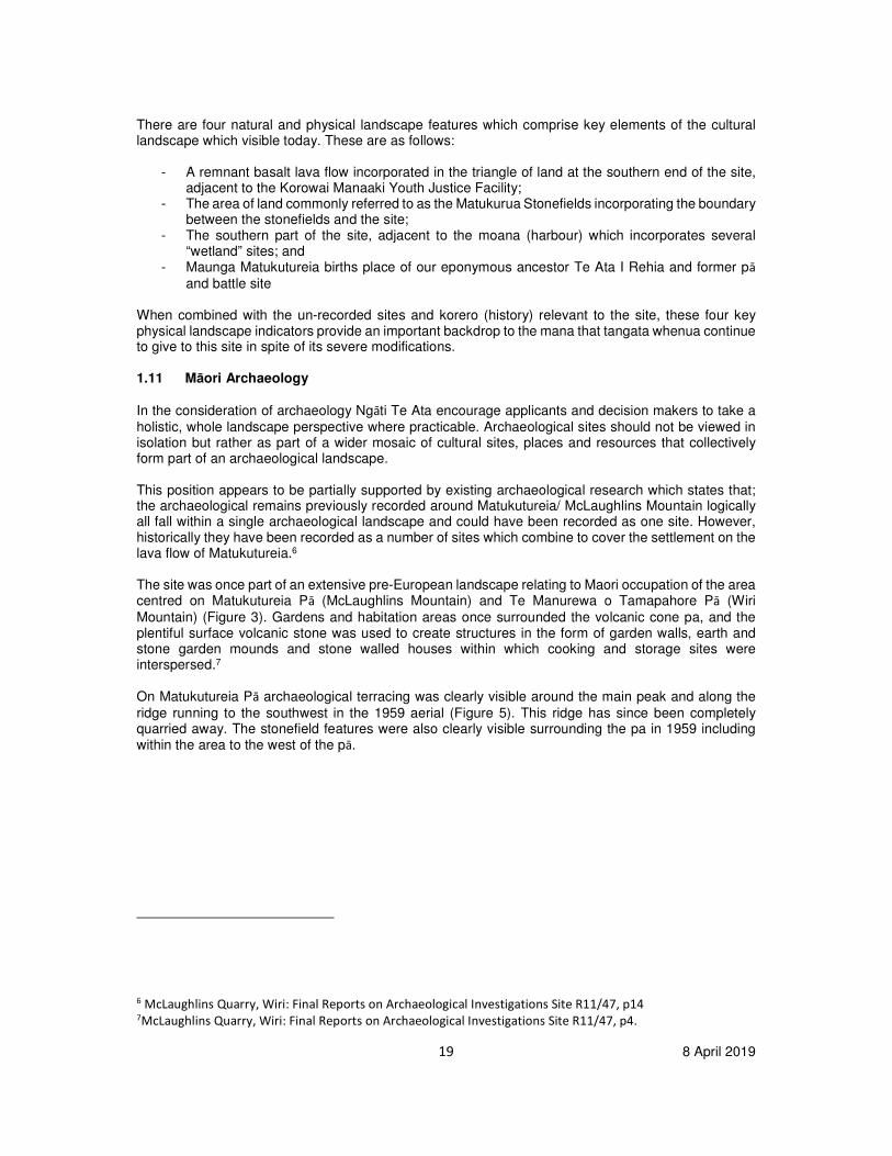
Mountain) (Figure 3). Gardens and habitation areas once surrounded the volcanic cone pa, and the plentiful surface volcanic stone was used to create structures in the form of garden walls, earth and stone garden mounds and stone walled houses within which cooking and storage sites were interspersed.7 On Matukutureia Pā archaeological terracing was clearly visible around the main peak and along the
ridge running to the southwest in the 1959 aerial (Figure 5). This ridge has since been completely quarried away. The stonefield features were also clearly visible surrounding the pa in 1959 including within the area to the west of the pā.
6 McLaughlins Quarry, Wiri: Final Reports on Archaeological Investigations Site R11/47, p14 7McLaughlins Quarry, Wiri: Final Reports on Archaeological Investigations Site R11/47, p4.
20 8 April 2019
Figure 5: 1959 Aerial Photo with overlays of Matukutureia Pā extent and stonefields.
The original geomorphology, together with the archaeology, traditions and history of this area, has been comprehensively reported by Agnes Sullivan and the description provides a baseline for understanding the subsequent modification (1989 pp.4-5):
“The southern volcanic cone (Matukutureia, Puhinui, McLaughlins Mt) was a breached crater open to the south-east. Steep slopes led up to a crater rim which was relatively broad on the south-east. A high cone piled upon the north end increased total height to around 90 m. A commanding view out over the Manukau Harbour and inwards up to the central Tamaki isthmus resulted. The northern cone (Matukutururu, Wiri Mt) was extensively quarried before any currently known record of it was made. Here the summit area appears to have been more restricted and the overall height and profile lower. Lava field surfaces varied continuously. The consistency of original lava sheets, the type of material traversed, and the amount of ash cover were among factors contributing to intricate combinations of sink holes, gullies, scarps, ridges, hillocks, outcrops and gentle slopes and flats which comprised the final lava field topography. Broad natural lava field subdivisions can be traced, more or less corresponding to the surface extent of individual lava spreads. Lava from Puhinui cone was laid down before some of the Wiri Mt lava, and forms most of the southern end of Matukurua. Wiri Mt lava covers a large northern area and extends downwards to the south partially covering lava from Puhinui cone. East and north of Puhinui cone a zone of great corrugations and deep hollows was formed where a sluggish flow of Wiri Mt lava was apparently checked and re-channelled below the base of the cone. Lava from Puhinui cone flowing out to the west formed a short, wide wedge with a relatively even surface and sharp, exterior edge scarp. The stonefield segment which is the subject of the appeal for preservation lies between these two areas. It compromises lava which flowed from the breached crater of Puhinui cone down to sea level in the Puhinui stream.
21 8 April 2019
The western part of this stonefield segment has, for convenience, been named Otakawai (calabash, water bottle, moist) from a 17th century traditional name associated with the zone. The eastern part has been similarly named Puhiroa (long eel) from a 17th century tradition. Both eastern and western portions were intact in 1939, but the upper parts of both areas nearest the Puhinui cone have since been heavily stripped and the greater part demolished. The lower ends are intact.”
Extensive quarrying has destroyed a substantial portion of the stonefield features, and only a small area of stone field remains survive in the southern part of the area, most of the remains being located within the Matukurua Historic Reserve next to the current McLaughlins Quarry property.
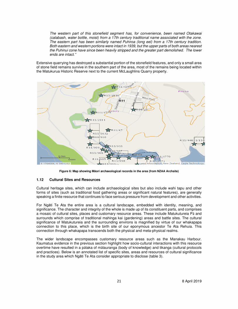
Figure 6: Map showing Māori archaeological records in the area (from NZAA Archsite)
1.12 Cultural Sites and Resources
Cultural heritage sites, which can include archaeological sites but also include wahi tapu and other forms of sites (such as traditional food gathering areas or significant natural features), are generally speaking a finite resource that continues to face serious pressure from development and other activities. For Ngāti Te Ata the entire area is a cultural landscape, embedded with identity, meaning, and significance. The character and integrity of the whole is made up of its constituent parts, and comprises a mosaic of cultural sites, places and customary resource areas. These include Matukutureia Pā and
surrounds which comprise of traditional mahinga kai (gardening) areas and battle sites. The cultural significance of Matukutureia and the surrounding environs is magnified by virtue of our whakapapa connection to this place, which is the birth site of our eponymous ancestor Te Ata Rehuia. This connection through whakapapa transcends both the physical and meta-physical realms. The wider landscape encompasses customary resource areas such as the Manakau Harbour. Kaumatua evidence in the previous section highlight how socio-cultural interactions with this resource overtime have resulted in a pātaka of mātauranga (body of knowledge) and tikanga (cultural protocols
and practices). Below is an annotated list of specific sites, areas and resources of cultural significance in the study area which Ngāti Te Ata consider appropriate to disclose (table 3).
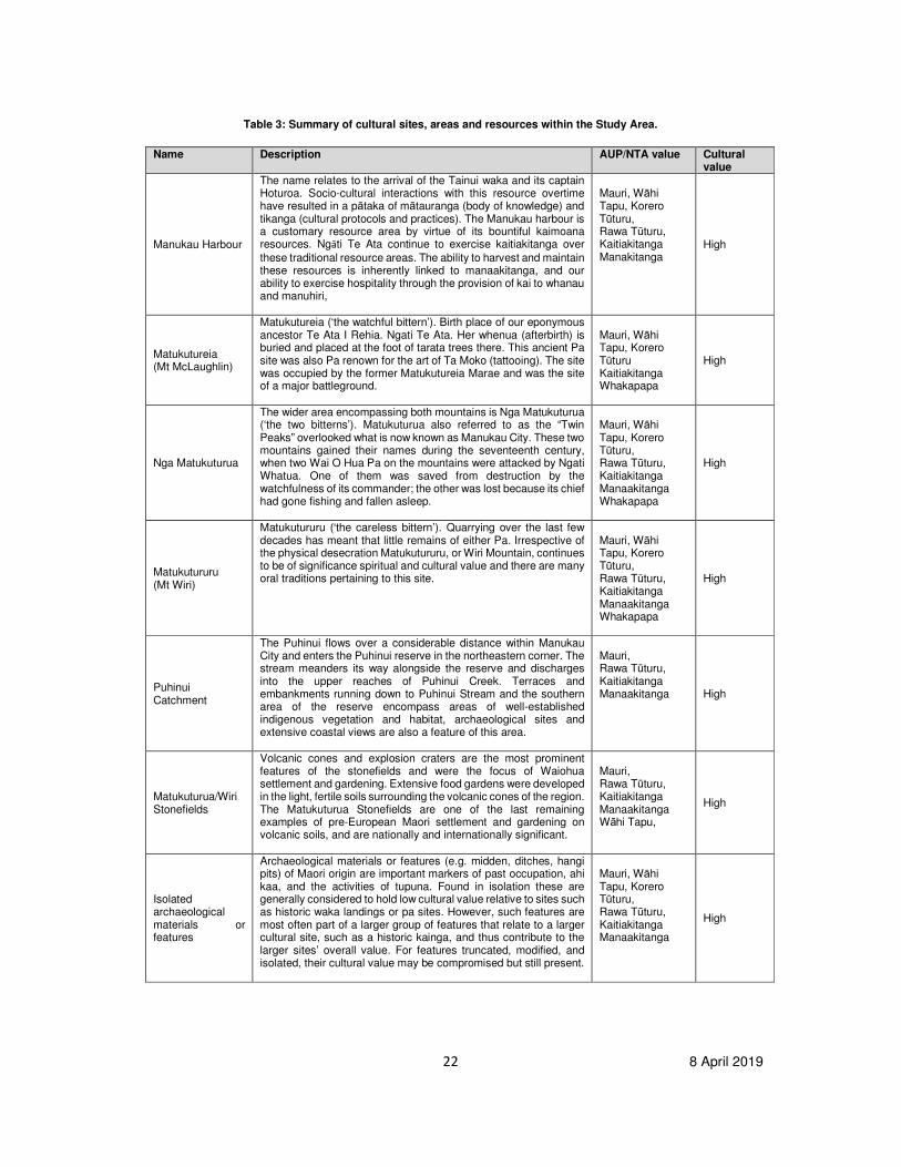
22 8 April 2019
Table 3: Summary of cultural sites, areas and resources within the Study Area.
Name Description AUP/NTA value Cultural value
Manukau Harbour
The name relates to the arrival of the Tainui waka and its captain Hoturoa. Socio-cultural interactions with this resource overtime have resulted in a pātaka of mātauranga (body of knowledge) and tikanga (cultural protocols and practices). The Manukau harbour is a customary resource area by virtue of its bountiful kaimoana resources. Ngāti Te Ata continue to exercise kaitiakitanga over
these traditional resource areas. The ability to harvest and maintain these resources is inherently linked to manaakitanga, and our ability to exercise hospitality through the provision of kai to whanau and manuhiri,
Mauri, Wāhi Tapu, Korero Tūturu, Rawa Tūturu, Kaitiakitanga Manakitanga
High
Matukutureia (Mt McLaughlin)
Matukutureia (‘the watchful bittern’). Birth place of our eponymous ancestor Te Ata I Rehia. Ngati Te Ata. Her whenua (afterbirth) is buried and placed at the foot of tarata trees there. This ancient Pa site was also Pa renown for the art of Ta Moko (tattooing). The site was occupied by the former Matukutureia Marae and was the site of a major battleground.
Mauri, Wāhi Tapu, Korero Tūturu Kaitiakitanga Whakapapa
High
Nga Matukuturua
The wider area encompassing both mountains is Nga Matukuturua (‘the two bitterns’). Matukuturua also referred to as the “Twin Peaks” overlooked what is now known as Manukau City. These two mountains gained their names during the seventeenth century, when two Wai O Hua Pa on the mountains were attacked by Ngati Whatua. One of them was saved from destruction by the watchfulness of its commander; the other was lost because its chief had gone fishing and fallen asleep.
Mauri, Wāhi Tapu, Korero Tūturu, Rawa Tūturu, Kaitiakitanga Manaakitanga Whakapapa
High
Matukutururu (Mt Wiri)
Matukutururu (‘the careless bittern’). Quarrying over the last few decades has meant that little remains of either Pa. Irrespective of the physical desecration Matukutururu, or Wiri Mountain, continues to be of significance spiritual and cultural value and there are many oral traditions pertaining to this site.
Mauri, Wāhi Tapu, Korero Tūturu, Rawa Tūturu, Kaitiakitanga Manaakitanga Whakapapa
High
Puhinui Catchment
The Puhinui flows over a considerable distance within Manukau City and enters the Puhinui reserve in the northeastern corner. The stream meanders its way alongside the reserve and discharges into the upper reaches of Puhinui Creek. Terraces and embankments running down to Puhinui Stream and the southern area of the reserve encompass areas of well-established indigenous vegetation and habitat, archaeological sites and extensive coastal views are also a feature of this area.
Mauri, Rawa Tūturu, Kaitiakitanga Manaakitanga High
Matukuturua/Wiri Stonefields
Volcanic cones and explosion craters are the most prominent features of the stonefields and were the focus of Waiohua settlement and gardening. Extensive food gardens were developed in the light, fertile soils surrounding the volcanic cones of the region. The Matukuturua Stonefields are one of the last remaining examples of pre-European Maori settlement and gardening on volcanic soils, and are nationally and internationally significant.
Mauri, Rawa Tūturu, Kaitiakitanga Manaakitanga Wāhi Tapu,
High
Isolated archaeological materials or features
Archaeological materials or features (e.g. midden, ditches, hangi pits) of Maori origin are important markers of past occupation, ahi kaa, and the activities of tupuna. Found in isolation these are generally considered to hold low cultural value relative to sites such as historic waka landings or pa sites. However, such features are most often part of a larger group of features that relate to a larger cultural site, such as a historic kainga, and thus contribute to the larger sites’ overall value. For features truncated, modified, and isolated, their cultural value may be compromised but still present.
Mauri, Wāhi Tapu, Korero Tūturu, Rawa Tūturu, Kaitiakitanga Manaakitanga
High
23 8 April 2019
Impact Assessment 1.13 Potential Direct Impacts
An Assessment of Environmental Effects (AEE) was not available at the time of writing this report
therefore this CIA draws from the applicant’s landscape assessment and archaeology report. The
applicant seeks to re-zone from special purpose – quarry to business – heavy industrial. The heavy
industrial zone already adjoins the northeastern border of Matukutureia and Matukuturua stone fields.
By reason of further intensification and encroachment the proposed rezoning of the existing business
park to heavy industry would further detract and have significant direct adverse impacts upon Ngāti Te
Ata values associated with Matukutureia and Matukuturua stonefields.
More intensive use of the site, which would be provided for under the proposed zone change, will also
have potentially adverse impacts upon the receiving environment. Potential effects arising from the
rezoning include increased noise, light and air pollution in addition to increased heavy vehicle
movements. This would result in further degradation to the mauri of the surrounding environment. This
impacts upon our ability to exercise kaitiakitanga and to provide for the maintenance, preservation and
enhancement of our waahi tapu and what natural and physical resources we have left in this location.
As kaitiaki part of our role is to improve the mauri of this waahi tapu and the surrounding landscape.
Mauri is the intangible life force that binds the living and physical world to the meta-physical realm and
is impacted by how we utilise and care for the land.
The removal of part of the ONF layer would further exacerbate the encroachment upon this significant
cultural landscape through the intrusion of further development and intensification. The permitted
baseline provided for under the business – heavy industrial zone needs to be given thorough
consideration. It is reasonable to anticipate that this would result in the introduction of potentially large
and austere industrial buildings and warehousing. This would have an unacceptable visual impact upon
the locational context of Matukutureia and the stone fields. It would also set a concerning precedent
under the Auckland Unitary Plan by reason of accommodating industrial expansion into greenfield areas
and significant cultural landscapes. This would further compound a legacy of historic grievances
pertaining to the destruction of waahi tapu in order to accommodate Auckland’s growth and
development. The Maunkau Harbour is part of the receiving environment and will be directly impacted
by further urbanisation in such close proximity.
The wellbeing of Ngāti Te Ata descendants is intrinsically linked to these sites and places and the
cultural landscape. The further piecemeal desecration and destruction of these sites and places, not
only impacts upon the physical landscape but the wellbeing of our people.
1.14 Potential Indirect Impacts
Indirect adverse impacts have potential to occur from both construction and operation. These include
erosion resulting from vegetation clearance; indirect impacts to the quality and mauri of the Manukau
Harbour, traffic impacts; changes to the presence or behaviours of indigenous animals arising from
secondary impact of habitat removal and modification; and the introduction of visitors to cultural sites
and the potential impact from certain behaviours on those sites.
1.15 Potential Cumulative Impacts
Cumulative effects are those that arise from the combination of past, present and future actives that
result in the scale and degree of impact being greater than the sum of its individual parts or activities.
24 8 April 2019
Cumulative effects can also be in-combination effects, or those that occur from one activity combined
with a different but contemporaneous activity that combine to cause additional elements of impact.
The urbanisation of Auckland has led to the quarrying of many of the maunga or volcanic cone pa, often
to the point where no physical remnants remain at all. Matukutururu a prime example. Housing
development, industrial intensification, roading and other infrastructure integral to a growing city have
developed in an ad-hoc way that has left the majority of archaeological sites and many waahi tapu
damaged, desecrated, or destroyed. This has resulted in a legacy of historical grievances many of
which are well documented and reflected in the Waitangi Tribunals; Manukau Report.
The protection or management of cultural heritage sites was legislated by the passing of the Resource
Management Act 1991 and the Historic Places Act 1993 (now Heritage New Zealand Act 2014) but the
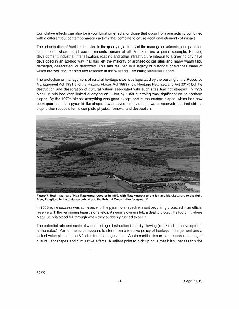
destruction and desecration of cultural values associated with such sites has not stopped. In 1939
Matukutūreia had very limited quarrying on it, but by 1959 quarrying was significant on its northern
slopes. By the 1970s almost everything was gone except part of the eastern slopes, which had now
been quarried into a pyramid-like shape. It was saved mainly due its water reservoir, but that did not
stop further requests for its complete physical removal and destruction.
Figure 7: Both maunga of Ngā Matukurua together in 1952, with Matukutūreia to the left and Matukutūruru to the right.
Also, Rangitoto in the distance behind and the Puhinui Creek in the foreground8
In 2008 some success was achieved with the pyramid-shaped remnant becoming protected in an official
reserve with the remaining basalt stonefields. As quarry owners left, a deal to protect the footprint where
Matukutūreia stood fell through when they suddenly rushed to sell it.
The potential rate and scale of wider heritage destruction is hardly slowing (ref: Fletchers development
at Ihumatao). Part of the issue appears to stem from a reactive policy of heritage management and a
lack of value placed upon Māori cultural heritage values. Another critical issue is a misunderstanding of
cultural landscapes and cumulative effects. A salient point to pick up on is that it isn’t necessarily the
8 ????
25 8 April 2019
physical destruction alone which causes the negative cultural and heritage impacts, but the activities
occurring upon them. For Ngāti Te Ata the placement of a toilet or the eating of food on or in the vicinity
of a particular cultural site can cause desecration to the site and impact on the wellbeing of the iwi.
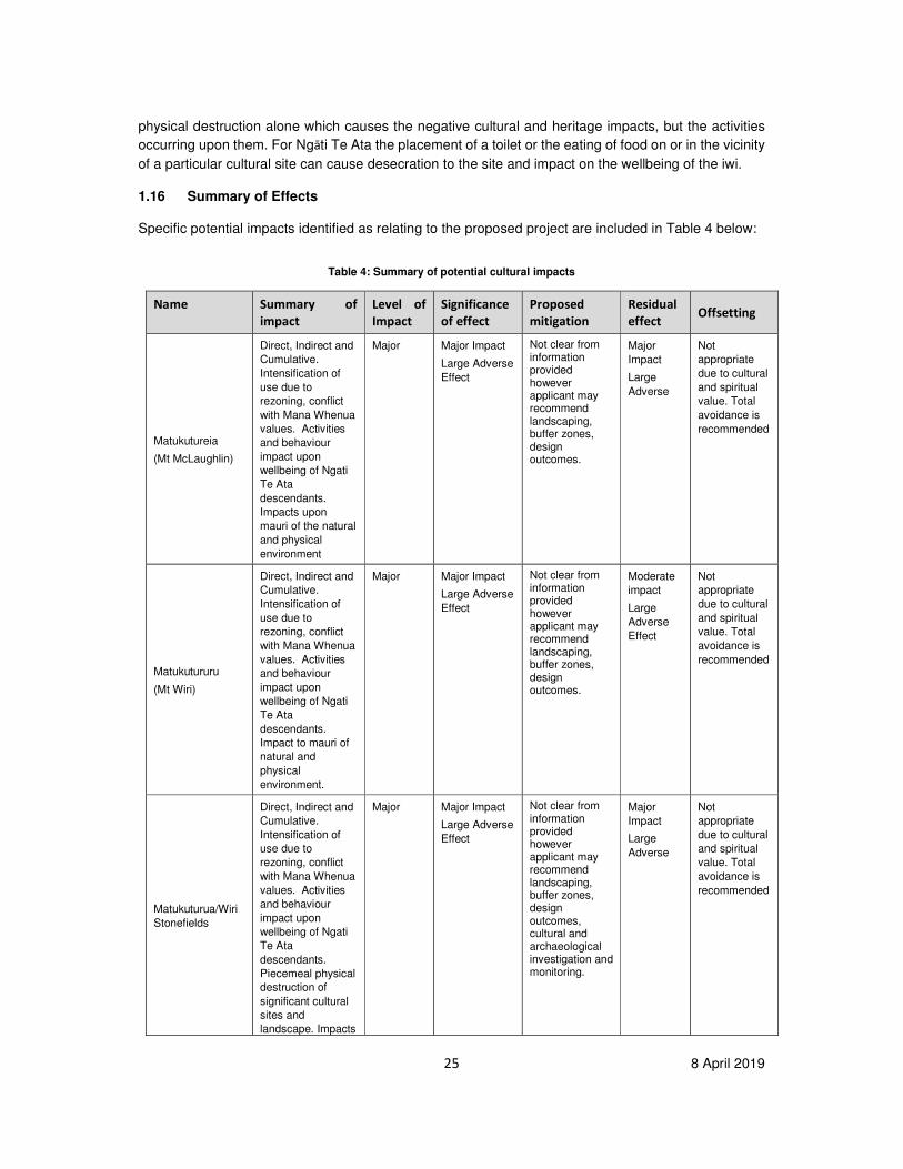
1.16 Summary of Effects
Specific potential impacts identified as relating to the proposed project are included in Table 4 below:
Table 4: Summary of potential cultural impacts
Name Summary of
impact
Level of
Impact
Significance
of effect
Proposed
mitigation
Residual
effect Offsetting
Matukutureia
(Mt McLaughlin)
Direct, Indirect and
Cumulative.
Intensification of
use due to
rezoning, conflict
with Mana Whenua
values. Activities
and behaviour
impact upon
wellbeing of Ngati
Te Ata
descendants.
Impacts upon
mauri of the natural
and physical
environment
Major Major Impact
Large Adverse
Effect
Not clear from information provided however applicant may recommend landscaping, buffer zones, design outcomes.
Major
Impact
Large
Adverse
Not
appropriate
due to cultural
and spiritual
value. Total
avoidance is
recommended
Matukutururu
(Mt Wiri)
Direct, Indirect and
Cumulative.
Intensification of
use due to
rezoning, conflict
with Mana Whenua
values. Activities
and behaviour
impact upon
wellbeing of Ngati
Te Ata
descendants.
Impact to mauri of
natural and
physical
environment.
Major Major Impact
Large Adverse
Effect
Not clear from information provided however applicant may recommend landscaping, buffer zones, design outcomes.
Moderate
impact
Large
Adverse
Effect
Not
appropriate
due to cultural
and spiritual
value. Total
avoidance is
recommended
Matukuturua/Wiri
Stonefields
Direct, Indirect and
Cumulative.
Intensification of
use due to
rezoning, conflict
with Mana Whenua
values. Activities
and behaviour
impact upon
wellbeing of Ngati
Te Ata
descendants.
Piecemeal physical
destruction of
significant cultural
sites and
landscape. Impacts
Major Major Impact
Large Adverse
Effect
Not clear from information provided however applicant may recommend landscaping, buffer zones, design outcomes, cultural and archaeological investigation and monitoring.
Major
Impact
Large
Adverse
Not
appropriate
due to cultural
and spiritual
value. Total
avoidance is
recommended
26 8 April 2019
Name Summary of
impact
Level of
Impact
Significance
of effect
Proposed
mitigation
Residual
effect Offsetting
upon mauri of the
natural and
physical
environment
Puhinui
Catchment
Direct, Indirect and
Cumulative.
Stormwater
discharges,
impacts upon mauri
of the natural and
physical
environment.
Cumulative impacts
from increased
impermeable
surface and heavy
industrial activities.
Moderate Moderate
Impact
Large Adverse
Effect
Not clear from information provided but may include engineered and natural storm water detention options. Buffer areas an landscaping, customary protocols and cultural monitoring
Minor
Impact
Moderate
adverse
effect
Required
Manukau Harbour
Direct, Indirect and
Cumulative.
Stormwater
discharges,
impacts upon mauri
of the natural and
physical
environment.
Cumulative impacts
from increased
impermeable
surface and heavy
industrial activities.
Moderate Moderate
Impact
Large Adverse
Effect
Not clear from information provided but may include engineered and natural storm water detention options. Buffer areas an landscaping, customary protocols and cultural monitoring
Minor
impact
Moderate
adverse
effect
Required
CONCLUSION Within Māori culture our ancestral lineage and lineage to the physical and natural elements that
surround us define our individual identity and who we are as a people. Our connection to this place and landscape through whakapapa to our eponymous ancestor Te Ata Rehuia cannot be understated and results in an enduring cultural and spiritual relationship to this location. Due to this intrinsic connection any destruction or disturbance to these sites and places directly impacts upon the wellbeing of Ngāti Te Ata descendants. This proposal would only serve to further desecrate and destroy our cultural heritage and waahi tapu and our relationship to it, and is reflective of historic pattern of development on and around the site. The proposal would result in an unacceptable level of intensification of the existing business park further encroaching upon our waahi tapu and adversely impacting upon our relationship to and ability to exercise kaitiakitanga over our significant sites and places and natural and physical resources. The partial removal of the ONF would only serve to further accelerate the continued piecemeal destruction of our significant sites and places and the wider cultural landscape. It is also considered that the proposed plan change is in conflict with the Auckland Regional Policy Statement provisions relating to Mana Whenua and natural heritage, and specifically the AUP provisions relating to avoidance of effects to ONFs (E19.3, D10.3.3), avoidance of intensification in areas containing scheduled items (B2.4.2.5(a), B8.3.2.2(b), E38.3.4), and avoidance of significant effects to Sites of Significance to Mana Whenua (B6.5.2(4), D21.2.1, D21.3.1, and potentially
27 8 April 2019
F2.16.3.6(b)). It is also our contention that the NZCPS may apply to the proposal, and is equally inconsistent with the provisions in the NZCPS. The reduction of an ONF in not only in a landscape already so harmed by historic quarrying and development, but in the wider Auckland context of loss, is unacceptable. Total avoidance is considered to be the only effective way of reducing these adverse cultural and spiritual effects to an acceptable level. On this basis Ngāti Te Ata will not entertain any offsetting
measures at this time. It should also be noted that a further assessment would be deemed appropriate once the Assessment of Environmental Effects has been prepared.
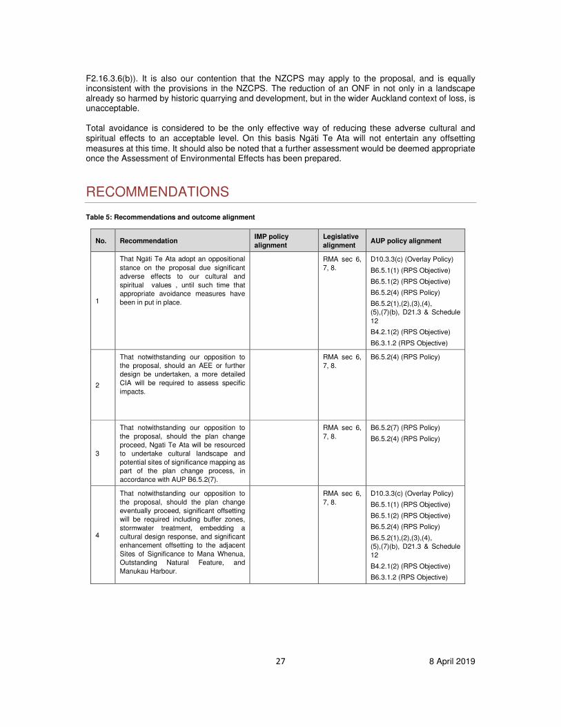
RECOMMENDATIONS
Table 5: Recommendations and outcome alignment
No. Recommendation IMP policy
alignment
Legislative
alignment AUP policy alignment
1
That Ngāti Te Ata adopt an oppositional
stance on the proposal due significant
adverse effects to our cultural and
spiritual values , until such time that
appropriate avoidance measures have
been in put in place.
RMA sec 6,
7, 8.
D10.3.3(c) (Overlay Policy)
B6.5.1(1) (RPS Objective)
B6.5.1(2) (RPS Objective)
B6.5.2(4) (RPS Policy)
B6.5.2(1),(2),(3),(4),
(5),(7)(b), D21.3 & Schedule
12
B4.2.1(2) (RPS Objective)
B6.3.1.2 (RPS Objective)
2
That notwithstanding our opposition to
the proposal, should an AEE or further
design be undertaken, a more detailed
CIA will be required to assess specific
impacts.
RMA sec 6,
7, 8.
B6.5.2(4) (RPS Policy)
3
That notwithstanding our opposition to
the proposal, should the plan change
proceed, Ngati Te Ata will be resourced
to undertake cultural landscape and
potential sites of significance mapping as
part of the plan change process, in
accordance with AUP B6.5.2(7).
RMA sec 6,
7, 8.
B6.5.2(7) (RPS Policy)
B6.5.2(4) (RPS Policy)
4
That notwithstanding our opposition to
the proposal, should the plan change
eventually proceed, significant offsetting
will be required including buffer zones,
stormwater treatment, embedding a
cultural design response, and significant
enhancement offsetting to the adjacent
Sites of Significance to Mana Whenua,
Outstanding Natural Feature, and
Manukau Harbour.
RMA sec 6,
7, 8.
D10.3.3(c) (Overlay Policy)
B6.5.1(1) (RPS Objective)
B6.5.1(2) (RPS Objective)
B6.5.2(4) (RPS Policy)
B6.5.2(1),(2),(3),(4),
(5),(7)(b), D21.3 & Schedule
12
B4.2.1(2) (RPS Objective)
B6.3.1.2 (RPS Objective)

28 8 April 2019
References LA4 Landscape Architects (2019), Technical Report 7: Landscape Assessment McLaughlins Quarry (2019), Wiri: Final Reports on Archaeological Investigations Site R11/47, Ngāti Te Ata, CIA for Proposed Mens Prison.