technical planning development …4071/obj/20002871.pdf · technical planning development...
TRANSCRIPT

LuLdC TfTcMQ M J
TECHNICAL PLANNING Development Control/Environmental Assessment
Situation Report 1991
ENVIRONMENT AGENCY
102335
TECHNICAL PLANNING
Development Control/Environmental Assessment Situation Report 199L
Introduction
This report documents activities in development concrol, quantifying mitigation and enhancement measures obtained by the NRA as a resulc of negotiations with developers following pre-planning enquiries and planning or land drainage consent applications. These discussions have usually taken place with the agreement and support of the relevant local authorities.Negotiations have resulted in increasing numbers of baseline surveys, both hydraulic and environmental, being carried out by the developer, in accordance with the NRA's statutory duties including those identified under section 8 of the 1989 Water Act, to assess the likely impacts of projects.NRA- (TR) has a presumption against the culverting of watercourses unless absolutely necessary. In addition the Authority generally objects to river realignment and straightening which can have geomorphological impacts, inducing instability and also destroying the natural channel with associated implications for flora and fauna. For many smaller day-to-day projects, Technical Planning staff advise using guidance notes (eg. golf courses, culverts and bank protection.More recently NRA (TR) has succeeded in negotiating wider river corridors, initially for access (a minimum of 8m), and increasingly wider corridors (up to 100m +) are being requested from the wildlife and conservation point of view. NRA (TR) is keen to sncourage developers to view rivers as key features of a development rather than engineering problems to be overcome.Contents
The input made by Technical Planning staff in negotiating environmentally acceptable solutions to developments over the past 4 months, either still in progress or completed after 31st December 1990, is recorded.
Only those projects of sufficient significance to record in this way have been included, although a similar approach is taken with a larger number of less significant cases. This summary allows the quality of work to be recorded as well as the basic number of planning applications/land drainage consents processed, which is the sole 'achievement' currently noted by the authority.Consideration of the various criteria adopted in this report, which may be capable of further development, may lead to improved reporting of the value of the Section's work in T.S. Quarterly Achievement Reports, as well as an enhanced measures of NRA influence at regional/national level. A series of draft Development Control Guidance Notes will increasingly ensure consistency in the content and quality of the approach to development proposals.
\wpfiles\AB\SitRepor.Intro
Summary Of ResultsRecurns from Che opening programme of the monitored proactive approach, ie. the first 3 months of 1991, show the following:
Total length of river enhancement Environmental Damage Avoided:
Very high : Category A
High level, local : Category B
Medium to high level, local : Category C Low level, local : Category DTotal Technical Planning Staff input Total value of engineering assets
" ” " environmental (data) assetsMinimum estimate of enhancements
- 38 Kms
- 5 schemes
- 8 schemes- 5 schemes
- 'J. schemei- 1234+ days.- £146,000.
- £90,000.
- £9 million.
It should be noted that staff time input to these major projects is not complete in all cases; if 200 days were allowed for completion, and an estimated 100 days allowed for support from other staff, together with 30% unproductive time (ie. a total of X m.y. approx), an output of £4.5 million per person per quarter is calculable. To the annual figure achieved should be added the cost (note, these costs probably understate the true value substantially) of flood defence asset creation, estimated in 1989/90 to be £40 million.
Conclusions
The NRA TR has found a significant way of achieving its goals through proactive intervention into development control, building on the Forward Planning/Catchment Planning Initiative. Valuable mitigation and enhancement measures are now being negotiated with developers, and will increasingly be based on the series of Development Control Guidance Notes.
Baseline studies, both hydraulic and environmental (including river corridor surveys) are now carried out by developers to assess the likely impacts of a project, and mitigation and enhancement measures are increasingly being considered as a integral part of a development package. Some basic measures of this influence _ on how the vast investment in land use change are practicable and helpful in determining the cost-effectiveness of che planning function.
\wpf iIes\AB\ConcIus i on.M i c

READING OFFICE
Location: ReadingNature of application: Development of gravel pit (Pre-planning)Proposed by: Redland Properties Ltd.Negotiations
The proposed site for development lies within the floodplain of the Thames in 30 year-old gravel extraction area, and covers an area of approximately 350 acres.
Peter Bretts Associates are constructing a mathematic model of the river floodplain at present.The N.R.A, has stressed that the hydraulic solution must not merely be local to the site, and should facilitate improvement of flood defence levels of service of Reading.NRA Departments consulted:
Recreation & Conservation, Aquatic Biology, Fisheries, Landscape Architecture, Pollution Control.Proposed treatment:
Still being discussed.SolutionStill being discussed.
Area of river/floodplain treatment: 1 km of River Thames and tributary.
Environmental damage averted: High local, with significant systemicimplications: Cat. B.
Time input by Technical Planning staff: Engineering 5 daysEnvironmental 2 davs
7 daysTotal Capital Value (of enhancements and mitigation1): Potentially very high/High: > £1 million.
Title of application: Caversham Lakes Development.
READING OFFICE
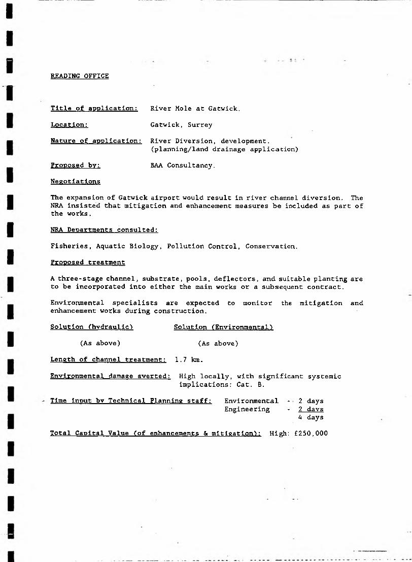
Location: Gatwick, Surrey
Nature of application: River Diversion, development.(planning/land drainage application)
Proposed bv: BAA Consultancy.Negotiations
Title of application: River Mole at Gatwick.
The expansion of Gatwick airport would result in river channel diversion. The NRA insisted that mitigation and enhancement measures be included as part of the works.NRA Departments consulted:
Fisheries, Aquatic Biology, Pollution Control, Conservation.Proposed treatment
A three-stage channel, substrate, pools, deflectors, and suitable planting are to be incorporated into either the main works or a subsequent contract.Environmental specialists are expected to monitor the mitigation and enhancement works during construction.Solution (hydraulic1 Solution (Environmental1)
(As above) (As above)Length of channel treatment: 1.7 km.
Environmental damage averted: High locally, with significant systemicimplications: Cat. B.
Time input by Technical Planning staff: Environmental - 2 daysEngineering - 2 davs
4 daysTotal Capital Value (of enhancements & mitigation^: High: £250,000

Title- of application: The Reading Oracle Development.
Location: Reading town centre.Nature of application: Land drainage consent.Proposed bv: Reading Borough Council.NegotiationsThe proposal is to straighten a short section of the River Kennet for development recreational reasons. The NRA wishes to minimise any channel realignment to avoid creating instability and as far as possible enhance the river environment.The Authority requested a desk study be carried out, to investigate the morphological impacts of the realignment. Another of the Authority's requirements is to ensure that a landscape architect carries out the final enhancement work to a specification dictated by the NRA.NRA Departments consulted:Aquatic Biology, Fisheries, Conservation, Landscape Architecture.Proposed treatment
READING OFFICE - - - - - =- = •
vr~l*\j ucuaxxd jf c l agiccuSolut ion (Hvdraulic) Solution (Environmental)
None as yet. Approx £20,000 None as yet.for studies etc.
Length of channel treatment: 100m
Environmental damage averted: Medium-High locally (some systemicimplications: Cat. C .
Time Input bv Technical Planning staff: Environmental) only studyEngineering) negotiations have
taken place so far.Total Capital Value (of solutions, enhancements & mitigation'): Medium:
> £100,000.

READING OFFICE
Title of application: Blackwater Valley Road. (Hampshire Section).
Location: Farnborough, Hampshire.Nature of application: Land drainage consent.Proposed by: Hampshire County Council.NegotiationsThere are to be five realignments to the river.Negotiations with engineering and environmental staff resulted in Hampshire County Council financing an Environmental Co-ordinator who will monitor the works during construction.NRA Departments consulted:Conservation, Fisheries, Aquatic Biology, Pollution Control.Proposed treatment
Mitigation measures include:- a two stage flood channel
distributions for the reinstated substrate.
Length of channel treatment: 3 - 5 km.
Environmental damage averted: High over long length of river, with high
- the construction of pools- bank treatment (eg. riprap and willow spiling).- other sensitive works.
Solution (Hydraulic) Solution (Environmental)Standard designs include reed storage and size
mitigation measures as mentioned above.
significant systemic applications: Cat. A.Time input bv Technical Planning staff: Environmental 7 days
Engineering 10 davs 17 days
Total Capital Value (of enhancements & mitigation): Very High> €1 million.

READING OFFICE
Location: Kennet Valley.Nature of application: Pre-planning.Proposed bv: A Consortium of gravel companies; including
ARC properties, Tarmac, Hall Aggregates.
Negotiations:Environmental coordination discussions are taking place.The developer's consultants are to carry out 8 to 10 baseline surveys including archaeology, wildlife, fisheries/angling, aquatic biology, recreation, minerals and waste, landscape and ornithology to NRA specification.NRA Departments consulted:Conservation, Fisheries, Aquatic Biology, Pollution Control, Water Quality, Water Resources.Proposed treatmentThe N.R.A, is giving advice on studies at this stage in the scheme. Solutions
Options under preparation.Length of river treatmentEnvironmental damage averted: Potentially very high over large local area,
with significant systemic implications for all NRA interests except navigation: Cat. A.
Time input bv Technical Planning staff: Environmental 3 daysEngineering 4 days
7 days
Total Capital Value (of solutions, enhancements and mitigation): Verh High, so far, about £50,000 of data collection. Estimated value of potential enhancements > £1 million.
Title of application: Kennet Valley Park.

READING OFFICE
Nature of application: Land drainage consent.Proposed by: Crest HomesNegotiationsThe Proposals of urban development involve a channel diversion. The brook involved is of sinuous nature in erodible sediments and therefore any planned straightening of the channel would need to be resisted.
Negotiations with Surrey County Council, McDowells and Crest were held, regarding the brook diversion.NRA Departments consulted:Fisheries, Maintenance Operations, Conservation.Proposed treatmentAppropriate mitigation and enhancement measures.Channel cross sections have been revised to emulate natural asymmetry of the diverted brook section, which is to be made sinuous. Gravel substrate will also be instated.Solution (Hydraulic’) Solution (Environmental’)
The size of flood storage Revised channel sections.and the ecological pondwould be decreased in orderto accommodate the course of thebrook. Also, instability wouldbe avoided as a result.Length of river treatment: 30m max.
Environmental damage averted: High locally with significant systemicimplications: Cat. B.
Time input bv Technical Planning staff: Environmental 1 dayEngineering 2 days
3 days
Title of application: Redhill Brook realignment
Location: Redhill, Surrey.
Total Capital Value (of enhancements & mitigation’): Medium €150,000

READING OFFICE
Location: Chertsey.Nature of application: Residential development (pre-planning stage) Proposed bv: Mount York Estates.Negotiations
The original plans encroached onto the river corridor.Also, the proposals lie in the flood plain, and the Authority advised against development.NRA Departments consulted:Conservation, Pollution Control, Operations.Proposed treatmentEnvironment mitigation/enhancement alongside the development.Solution (Hydraulic) Solution (Environmental)
N/A NRA has negotiated the enhancements oftree and shrub planting.
Length of river treatment: about h kmManpower Time input: (Environmental) h day.
(Engineering) 1 day.
Environmental damage averted: Low, local: Cat. D.
Time input by Technical Planning Staff: Environmental H dayEngineering 1 day
7H daysTotal Capital Value (of solution, enhancements & mitigation'): Low: £50,000
Title of application: Eastworth Road, Chertsey.

READING OFFICE
Location: Reading.Nature of application: Development of river floodplain.Proposed bv: Pitnile Ltd.NegotiationsInitial proposals were to build a car park, bus shelter and associated facilities on the river floodplain.No Environmental Assessment of the site was done.The NRA refused the proposals on the grounds that the scheme would be detrimental to the environment, (loss of river corridor), and considerably affect the flood capacity of the reach.Compensatory flood storage would need to be found.NRA Departments consulted:
Conservation, Pollution Control, Operations.Proposed treatment None as yet.Solution (Hydraulic) Solution (Environmental)
No solutions found yet. N/ALength of river treatment: 350m
Environmental damage averted: High locally, with some systemic implications:Cat. C.
Time input bv Technical Planning staff: Environmental 2 daysEngineering 2 davs
4 daysTotal Capital Value (of solutions, enhancements & mitigation): Medium:
Environmental Studies £20,000 Enhancements >£80,000
Title of application; Park and Ride scheme at Loddon Bridge.
READING OFFFICE
Title of application:
Location:
Nature of application:
Proposed by: Negotiations
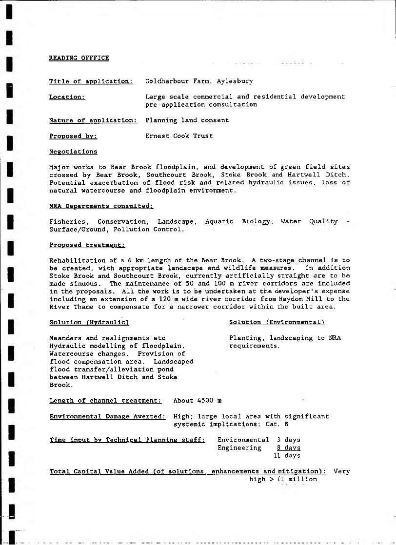
Coldharbour Farra, AylesburyLarge scale commercial and residential development pre-application consultation
Planning land consent
Ernest Cook Trust
Major works to Bear Brook floodplain, and development of green field sites crossed by Bear Brook, Southcourt Brook, Stoke Brook and Hartwell Ditch. Potential exacerbation of flood risk and related hydraulic issues, loss of natural watercourse and floodplain environment.NRA Departments consulted:Fisheries, Conservation, Landscape, Aquatic Biology, Water Quality Surface/Ground, Pollution Control.Proposed treatment:Rehabilitation of a 6 km length of the Bear Brook. A two-stage channel is to be created, with appropriate landscape and wildlife measures. In addition Stoke Brook and Southcourt Brook, currently artificially straight are to be made sinuous. The maintenance of 50 and 100 m river corridors are included in the proposals. All the work is to be undertaken at the developer's expense including an extension of a 120 m wide river corridor from Haydon Mill to the River Thame to compensate for a narrower corridor within the built area.Solution (Hydraulic) Solution (Environmental)
Meanders and realignments etc Hydraulic modelling of floodplain.Watercourse changes. Provision of flood compensation area. Landscaped flood transfer/alleviation pond between Hartwell Ditch and Stoke Brook.Length of channel treatment: About 4500 m
Environmental Damage Averted: High; large local area with significantsystemic implications: Cat, B
Time input by Technical Planning staff: Environmental 3 daysEngineering 8 days
11 days
Planting, landscaping to NRA requirements.
Total Capital Value Added (of solutions, enhancements and mitigation): Veryhigh > £1 million
READING OFFICE
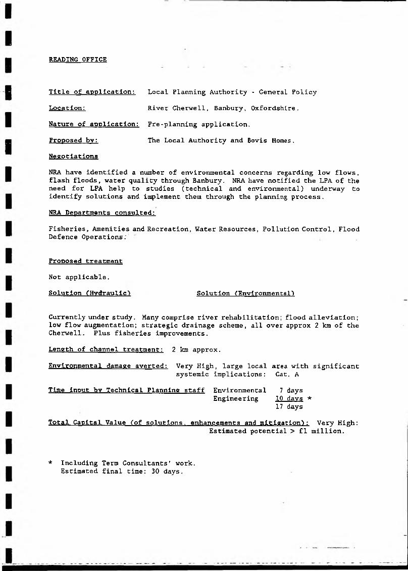
Nature of application: Pre-planning application.Proposed by: The Local Authority and Bovis Homes.Negotiations
NRA have identified a number of environmental concerns regarding low flows, flash floods, water quality through Banbury. NRA have notified the LPA of the need for LPA help to studies (technical and environmental) underway to identify solutions and implement them through the planning process .NRA Departments consulted:
Fisheries, Amenities and Recreation, Water Resources, Pollution Control, Flood Defence Operations;
Proposed treatment Not applicable.Solution (Hydraulic Solution (Environmental')
Currently under study. Many comprise river rehabilitation; flood alleviation; low flow augmentation; strategic drainage scheme, all over approx 2 km of the Cherwell. Plus fisheries improvements.Length of channel treatment: 2 km approx.
Environmental damage averted: Very High, large local area with significantsystemic implications: Cat. A
Time input bv Technical Planning staff Environmental 7 daysEngineering 10 davs *
17 daysTotal Capital Value (of solutions, enhancements and mitigation^: Very High:
Estimated potential > £1 million.
Title of application: Local Planning Authority - General Policy
Location: River Cherwell, Banbury, Oxfordshire.
* Including Term Consultants' work. Estimated final time: 30 days.

READING OFFICE
Nature of application: Pre-planning application
Proposed by: Oxfordshire County CouncilNegotiations- Flood defence concerns, increased flood risk to Witney.- Environmental - diversions of watercourse and major structures over E & W
arms of Windrush floodplain.- Fisheries - EEC designated salmonid fishery.NRA Departments consulted:Aquatic Biology, Conservation, Fisheries, Pollution Control.Proposed treatment:
(Under negotiation) All this yet to be agreed by Technical Planning (EA Section).Geotextile seeded and planted to diverted watercourses outside main structures. Oversized culverts for secondary watercourses. Proposed 'Armoflex' revetment of sections beneath main structures, could be coloured concrete and will leave the bed of channels undisturbed. Downstream, river grading works to west channel normally not supported by NRA but may form part of fisheries improvement scheme.Solution (Hydraulic) Solution (Environmental’)To be agreed. River corridor survey
requested.Oxfordshire County Council are paying 50% of hydraulic/ hydrological modelling studies to look at these and wider NRA interests, ie. £20,000.
Length of channel treatment: Minimum 500 m.Environmental damage averted: Medium to High, locally: Cat. CTime Input by Technical Planning staff: Environmental 2 days
Engineering 5 days- - 7 days
Total Capital Value (of solutions, enhancements and mitigation1): High Contribution Estimated following negotiation - > £500,000
Title of application: Cogges Link Road, Witney
Location: Witney, Oxfordshire
READING OFFICE
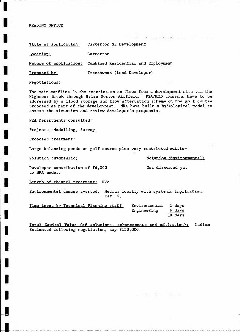
Nature of application: Combined Residential and Employment Proposed by: Trenchwood (Lead Developer)
Negotiations:The main conflict is the restriction on flows from a development site via the Highmoor Brook through Brize Norton Airfield. PSA/MOD concerns have to be addressed by a flood storage and flow attenuation scheme on the golf course proposed as part of the development. NRA have built a hydrological model to assess the situation and review developer's proposals.NRA Departments consulted:Projects, Modelling, Survey.Proposed treatment:Large balancing ponds on golf course plus very restricted outflow.Solution (Hydraulic) Solution (Environmental')Developer contribution of €6,000 Not discussed yetto NRA model.Length of channel treatment: N/AEnvironmental damage averted: Medium locally with systemic implication:
Cat. C.Time input by Technical Planning staff: Environmental 2 days
Engineering 8 davs 10 days
Total Capital Value (of solutions, enhancements and mitigation): Medium: Estimated following negotiation; say £150,000.
Title of application: Carterton NE Development
Location: Carterton

READING OFFICE
Title of application: Location:Nature of application:
Proposed bv: Negotiations
A418 Aylesbury Bypass Wing to Aylesbury, Bucks.
Pre-planning.DTp/Bucks County Council
Crossing of Thame floodplain and approximately another thirty main/non main river watercourses by a major new road. Cuttings proposed through Bedgrave and Stoke Brooks at Aylesbury, requiring inverted syphons for continuation of the watercourses beneath the cuttings. Pumped road drainage requiring balancing ponds and pollution control measures outside cuttings.NRA Departments consulted:None as yet.Proposed treatment:To be discussed in detail. NRA have stated that environmental enhancement, particularly with regard to mitigating the effects of the cuttings south of Aylesbury will be required. This is a most intractable problem, all the more so because the DTp resisted earlier invitations to a partnership approach.Solution (Hvdraulic) Solution ('Environmental)To be agreed. To be agreed.Outlines contained in To start, river corridor survey ofPeter Brett Associates 1.5 km for each watercourse crossing, report for the cuttings.
Length of channel treatment: > 30 road crossings of main/non main rivers.
Environmental damage averted: Very high with many significant systemicimplications: Cat. A.
Time input of Technical Planning staff: Environmental 1 dayEngineering 15 days *
16 days
Total Capital Value (of solutions, enhancements and mitigation): Very High>£1 million.
* Including Term Consultants' time.

READING OFFICE
Location: Poyle, Near Slough.Nature of application: Planning ApplicationProposed bv: Douglas Norwood Architects (on behalf of Gulf Air) Negotiations
Title of application: Poyle Manor Hotel.
The NRA objected on two grounds:- Breach of NRA Byelaw: The development plans did not include an 8 m wide maintenance strip, adjacent to the Poyle Channel, for use as access by the NRA.
- The proposed development would have a detrimental effect on the water environment, and would conflict with the Authority's wildlife corridor policy.
These objections were in addition to restrictions on the architect's solution (of accommodating the hotel), by other bodies.Proposed treatment
Environmental enhancement of the river corridor. • •NRA Departments consulted:
Land Drainage, Surfacewater Pollution, Groundwater Pollution, Amenities and Recreation, Fisheries, Operations, Projects.Solution:After further discussions, the developer produced revised plans which included a corridor of minimum width 8 m. In addition to this revised corridor width, further discussions produced enhancement measures which included landscaping of the environment in the vicinity of the river corridor, planting and improved public access to the river.Discussions with Spelthorne Borough Council have been an essential element in this case and are continuing.
Length of channel treatment: 300 m
Environmental damage averted: Medium-high locally: Cat. C.Time input bv Technical Planning staff: Environmental 1 day
Engineering 1 day2 days
Total Capital Value (of solutions, enhancements and mitigation): Medium£100,000.

READING OFFICE
Location: LightwaterNature of application: (Unlawful action)Proposed bv: N/A
NegotiationUnlawful tipping by an individual occurred next to a river channel. This had the effect of raising ground levels. Surrey County Council recommended enforcement action.NRA Departments consulted:Aquatic Biology, River Operations, Land Drainage, Pollution Control, Water Resources, Groundwater ProtectionProposed treatment:
The NRA has suggested mitigation and enhancement measures which include planting. An 8 m corridor is intended to be created along the length of the river.Solution (Hydraulic) Solution (Environmental)
N/A N/ALength of river treatment: 100 m
Environmental damage averted: Low locally (over small length of river)Time input by Technical Planning staff: (Environmental) 5 hours maximum.
(Engineering)Total Capital Value (of solutions, enhancements & mitigation'): Low: £5,000
Title of application: Brooklands farm

READING OFFICE
Location: Woking.
Nature of application: Filling of land for agricultural purposes.Proposed by: Chambers Homefield Sandpit Ltd.NegotiationsObjection was made to a planning application to fill a wetland in order to convert it to agricultural land. The reasons for the objections were; loss of habitat and concern about flood water levels.The channel a affected is a non-main river.NRA Departments consulted:
Water Resources, Amenity and Conservation, Fisheries, River Operations, Pollution Control, Land Drainage, Groundwater Protection.Proposed treatmentSee below.Solution (Hydraulic) Solution (Environmental)
The developers are Minor enhancements are to be agreed.constructing a floodstorage pond as aminimum requirement fromthe NRA.
Length of river treatment: 2 km of minor channel.
Environmental damage averted: High locally, significant systemicimplications: Cat. B.
Time input by Technical Planning staff: Environmental 1 dayEngineering 3 days
4 daysTotal Capital Value (of solutions, enhancements & mitigation): £50,000
Title of application: Whitmoor Wood, Woking.
LONDON OFFICE
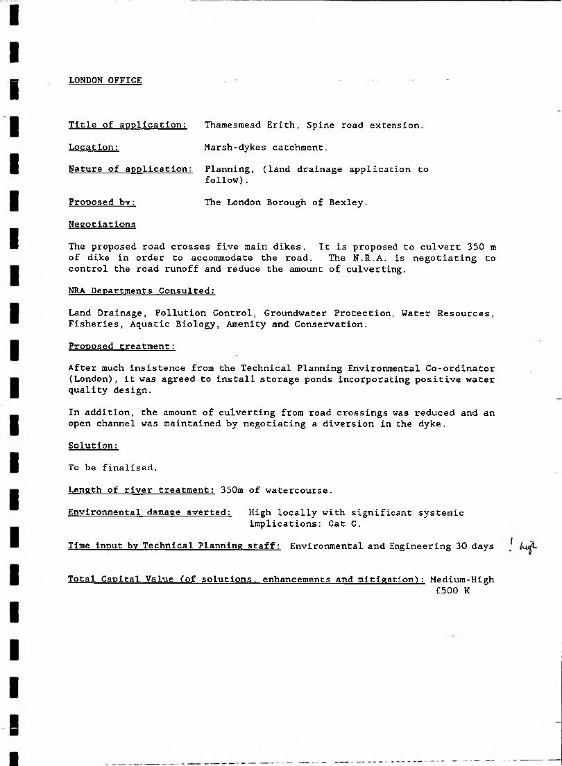
Title of application: Thamesraead Erith, Spine road extension.
Location: Marsh-dykes catchment.Nature of application: Planning, (land drainage application to
follow).Proposed bv: The London Borough of Bexley.Negotiations
The proposed road crosses five main dikes. It is proposed to culvert 350 m of dike in order to accommodate the road. The N.R.A, is negotiating to control the road runoff and reduce the amount of culverting.NRA Departments Consulted:
Land Drainage, Pollution Control, Groundwater Protection, Water Resources, Fisheries, Aquatic Biology, Amenity and Conservation.Proposed treatment:After much insistence from the Technical Planning Environmental Co-ordinator (London), it was agreed to install storage ponds incorporating positive water quality design.
In addition, the amount of culverting from road crossings was reduced and an open channel was maintained by negotiating a diversion in the dyke.Solution:To be finalised.
Length of river treatment: 350m of watercourse.Environmental damage averted: High locally with significant systemic
implications: Cat C.Time input bv Technical Planning staff: Environmental and Engineering 30 days
Total Capital Value (of solutions, enhancements and mitigation') : Medium-High£500 K
LONDON OFFICE
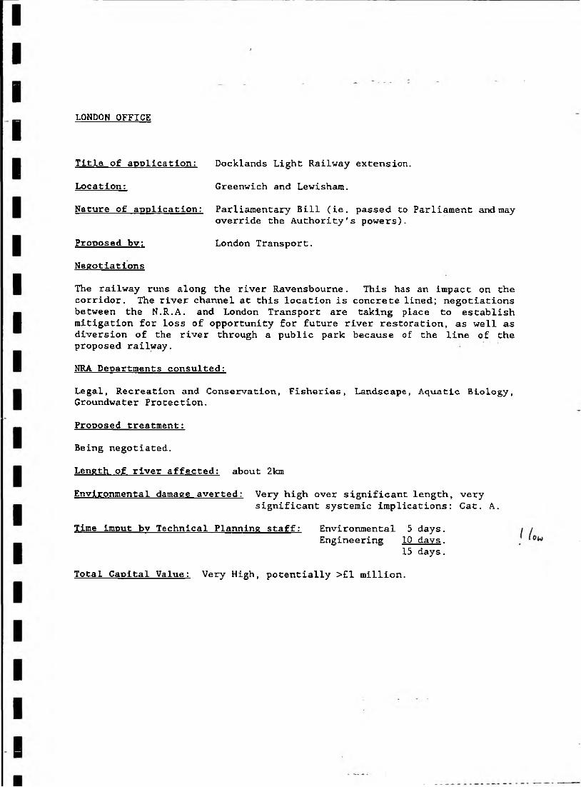
Location: Greenwich and Lewisham.Nature of application: Parliamentary Bill (ie. passed to Parliament and may
override the Authority's powers).Proposed bv: London Transport.Negotiations
The railway runs along the river Ravensbourne. This has an impact on the corridor. The river channel at this location is concrete lined; negotiations between the N.R.A, and London Transport are taking place to establish mitigation for loss of opportunity for future river restoration, as well as diversion of the river through a public park because of the line of the proposed railway.NRA Departments consulted:
Legal, Recreation and Conservation, Fisheries, Landscape, Aquatic Biology, Groundwater Protection.Proposed treatment:Being negotiated.
Length of river affected: about 2km
Environmental damage averted: Very high over significant length, verysignificant systemic implications: Cat. A.
Time lmput bv Technical Planning staff: Environmental 5 days.Engineering 10 days.
15 days.
Title of application: Docklands Light Railway extension.
Total Capital Value: Very High, potentially >£1 million.
WALTHAM CROSS OFFICE
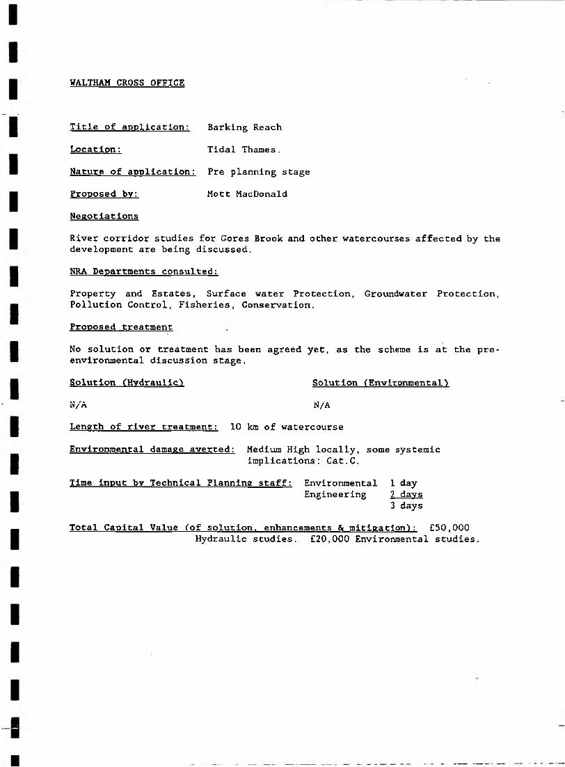
Title of application: Barking Reach
Location: Tidal Thames.Nature of application: Pre planning stage Proposed bv: Mott MacDonaldNegotiations
River corridor studies for Gores Brook and other watercourses affected by the development are being discussed.NRA Departments consulted:
Property and Estates, Surface water Protection, Groundwater Protection, Pollution Control, Fisheries, Conservation.Proposed treatment
No solution or treatment has been agreed yet, as the scheme is at the pre- environmental discussion stage.Solution (Hydraulic) Solution (Environmental)N/A N/ALength of river treatment: 10 km of watercourse
Environmental damage averted: Medium High locally, some systemicimplications: Cat.C.
Time Input bv Technical Planning staff: Environmental 1 dayEngineering 2 days
3 daysTotal Capital Value (of solution, enhancements & mitigation): €50,000
Hydraulic studies. £20,000 Environmental studies.

WALTHAM CROSS OFFICE
Nature of application: Pre-planning stage.
Proposed bv: Trafalgar House Business Parks.Negotiations
Proposals to create water features on Quinton Hall Brook, NRA negotiated the installation of off-line features as opposed to on-line features.Improvements in the river capacity were also established.NRS Departments consulted:
Water Resources, Navigation, Fisheries.Proposed treatment
The NRA accepted proposals, in principle, for off-line features of a more natural course of river.Solution (Hydraulic) Solut ion (Environment a 1)N/A N/ALength of river treatment: 1 to 2 km.
Environmental damage averted: High locally, significant systemicimplications: Cat. B,
Time Input by Technical Planning staff: Environmental: 1 dayEngineering: 6 davs
7 daysTotal Capital Value (of solution, enhancements & mitigation): Medium:
> £250,000
Title of application: Royal Ordnance Site, Enfield
Location: Enfield, Middlesex.

Development Control Guidance Note 1. ('Draft')
Culverting Issues
Developers' arguments, and suggested answers
(1) channels in urban areas are often regarded as rubbish tips. Regular clearance of this rubbish (to prevent flooding) is at the taxpayers expense (ref: Slough).
A. enhancement/creation of channel reduces mistreatment and encourages interest in maintaining community asset.
(2) safety issue where the river is apparently at risk of undercutting the embankment of a dam (ref: London Borough of Croydon).
A. safety aspects can be resolved without recourse to culverting-and more cheaply.
(3) safety issue: open channels are dangerous for children.A. natural channels with variably-sloping banks are not dangerous, and are
recreational assets.(4) money available to spend on capital projects (such as culverting). No
money for maintenance of an open channel.A. spend capital on enhancement/provision of community asset, take advice
on minimising maintenance.(5) open channels encourage rats. Can be a hazard where development
includes food outlets (ref: River Cole).A. rats also inhabit sewers.(6) aesthetic issues. A culvert replaces an unsightly ditch.A. see 4 - why is it unsightly?(7) odours in open watercourses.A. see 4 - odours are not inescapable, but can be minimised by good
design.(8) open watercourses more likely to flood (ref: East Herts)A. if upstream development increases flood risk, is a culvert the best
starting point for improvement?(9) need to maximise area of development (eg. for car parking).A. in urban area, both human and wildlife communities need a good
environment - river corridors represent a small, precious fraction of the total land available for car parking in the catchment.
Problems associated with culverting(1) Geomorphology. Loss of pool-riffle sequence and natural substrate.
Increased velocities may cause downstream erosion.
(2) Wildlife. Loss of marginal and aquatic vegetation. Loss of natural substrate and diversity.
(3) Fisheries. Potential loss of natural habitat, unknown effects on natural migrations of fish. Precise impact depends on type/length of culvert.
(4) Hydraulics. Potential upstream and downstream flooding. Loss of floodplain storage.
(5) Maintenance. Potential for blockage. Difficult/danger in clearing blockage under storm conditions.
V I

(6) Water Quality. Loss of beneficial action from aquatic vegetation; unable to trace a polluting source.
(7) Loss of recreation/amenity facility/potential.(8) Loss of landscape.
(9) Health and Safety. Problems for children and with maintenance. Gases/petroleum vapour. Rescue access difficult.
Circumstances where culverts might be acceptable
Road crossings with suitable replacement of substrate. However clear, single- spah structure with natural inverts may be more appropriate.Mitigation/enhancement criteriaIf culverting is necessary then minimise length. Minimise slope increase along culverted section and choose satisfactory alignment with channel upstream and downstream. Preserve natural bed. Maximise cross-section of culvert and use box in preference to pipe. Preserve floodplain flow routes and characteristics.Size culvert to permit future regrading of channel if necessary and allow replacement of natural bed material.Minimise tree removal. Reinstate land above and alongside culvert with appropriate native trees and shrub planting and wildflower seed mixes.
If culverting is absolutely necessary then there should be extensive provision of access openings for entry/exit/ ventilation and for monitoring sewer outfalls.
Any culverting should be regarded as causing adverse environmental impact which should be fully mitigated and offset by suitable environmental enhancements.
Guide to circulation.
Applications for culverting should be circulated to:Fisheries,Conservation,Environmental CoordinatorRiver Operations (for main river),Land Drainage,Biology.
Andrew Brookes 12/1/91 Revised 24/5/91
\wpfiles\AB\Note1.Hie

Golf Courses
Development Control Guidance Note 2 (Second draft)
Developers arguments, and suggested answers(1) The need for recreation facilities and benefits to the community etc.A. A 'natural' river corridor adds interest and habitat diversity without
inhibiting facilities.(2) Promises to preserve some areas of wildlife value.A. What wildlife need is conservation of the vital continuum provided by
a river corridor, linking areas planned for 'preservation'.(3) The turning of farm land and industrial land into golf courses may well
improve the environmental value of the land.A. Our advice can optimise this welcome improvement.(4) Creation of areas of rough - sowing of wild seeds etc to replace the
natural habitat that has been removed.A. The river corridor is a specialist's area - rough-sowing may be
entirely unsuitable.Problems Associated with Golf Courses(1) Damage to river banks resulting from heavy machinery working too close
(see photographs in archive). This leads to instability, slumping and erosion.
(2) Destruction of marginal and bankside vegetation associated with (1) above. Trees and shrubs are often cut down and removed to facilitate clear sighting of tees etc. This leads to further bank instability and a decrease in shade and cover affecting fisheries and wildlife interests in the channel (eg. increased temperature, decrease dissolved oxygen).
(3) Increased surface water run-off due to removal of trees, improved drainage under greens, irrigation etc. This could affect the hydrograph and as well as causing localised erosion could lead to flooding problems downstream. (This depends on the location of the golf course in the Catchment e.g. headwaters or in floodplain downstream). Re-landscaping can affect the catchment boundaries which may also increase run-off etc.
(4) Loss of floodplain storage and flood flow routes due to landscaping etc. This can cause upstream and downstream flooding.
(5) Culverting of minor ditches and streams. See guidance note (1) for implications.
(6) Construction causes temporary problems such as siltation, local ponding and flooding. Dewatering may have pollution control implications.
(7) Water features such as on-stream lakes lead to widening and excavation of the river bed. These have adverse consequences such as habitat destruction, the deterioration of water quality during construction, due to suspended solids, or after the works due to algal blooms.
. . ./I
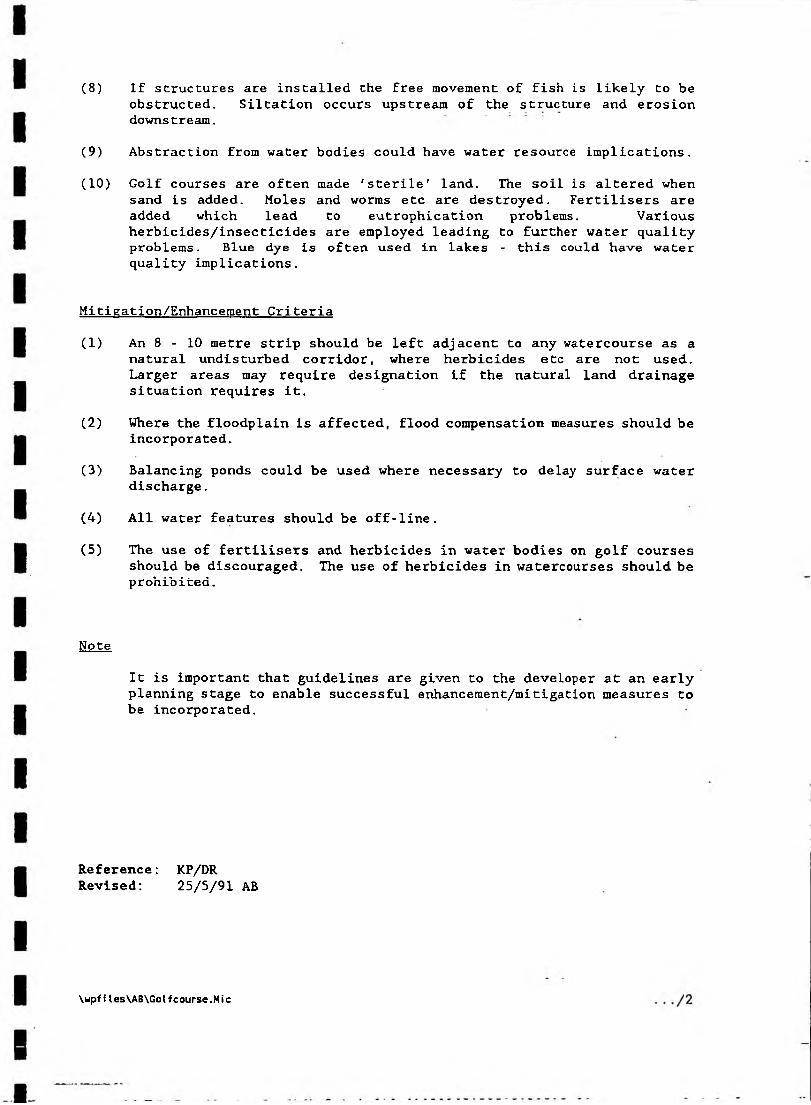
(8) If structures are installed the free movement of fish is likely to be obstructed. Siltation occurs upstream of the structure and erosion downstream.
(9) Abstraction from water bodies could have water resource implications.(10) Golf courses are often made 'sterile' land. The soil is altered when
sand is added. Moles and worms etc are destroyed. Fertilisers are added which lead to eutrophication problems. Various herbicides/insecticides are employed leading to further water quality problems. Blue dye is often used in lakes - this could have water quality implications.
Mitigation/Enhancement Criteria(1) An 8 - 10 metre strip should be left adjacent to any watercourse as a
natural undisturbed corridor, where herbicides etc are not used. Larger areas may require designation if the natural land drainage situation requires it.
(2) Where the floodplain is affected, flood compensation measures should be incorporated.
(3) Balancing ponds could be used where necessary to delay surface water discharge.
(4) All water features should be off-line.(5) The use of fertilisers and herbicides in water bodies on golf courses
should be discouraged. The use of herbicides in watercourses should be prohibited.
Note
It is important that guidelines are given to the developer at an early planning stage to enable successful enhancement/mitigation measures to be incorporated.
Reference: KP/DR Revised: 25/5/91 AB
\wpfiles\AB\Golfcourse.Mic

Development Control Guidance Note 4 (Draft)
BANK PROTECTION WORKS
Developers' arguments, and suggested answers
(1) Perceived erosion problem.A. Explain why this is a perceived problem only.(2) Safety issue - where a river is apparently at risk of undercutting a
building/structure.A. Ditto(3) Development pressure - bank protection may permit a greater area of
land to be developed.A. River corridor is a small but very special/valuable fraction of total
land mass, and should be protected as such.Problems with bank protection1. Geomorphology
2. Wildlife
3. Fisheries
4. Hydraulics5. Water Quality
6. Landscape
7. Health and Safety
- loss of natural bank profiles.- impact on bed of channel where bank protection works require footings/protective apron into the channel.
- loss of marginal habitat and bankside trees and shrubs.
- long stretches of bank protection works mean a considerable disruption to the rivsr corridor.
- artificial vertical banks curtail free access of wildlife from the bank to the water.
- loss of hiding places in and under the bank for fish and other organisms.
- loss of marginal and bankside vegetation leading to impoverishment of the habitat eg loss of shade from tree cover.
- possible loss of channel capacity.
- loss of marginal reed beds may have detrimental effect on water quality.
- unsympathetic bank protection works may be visually intrusive.
- long sections of vertical banks resulting from hard bank protection works create safety problems.
Circumstances where bank protection might be acceptable1. Where a building or other structure is threatened by erosion.
•/I
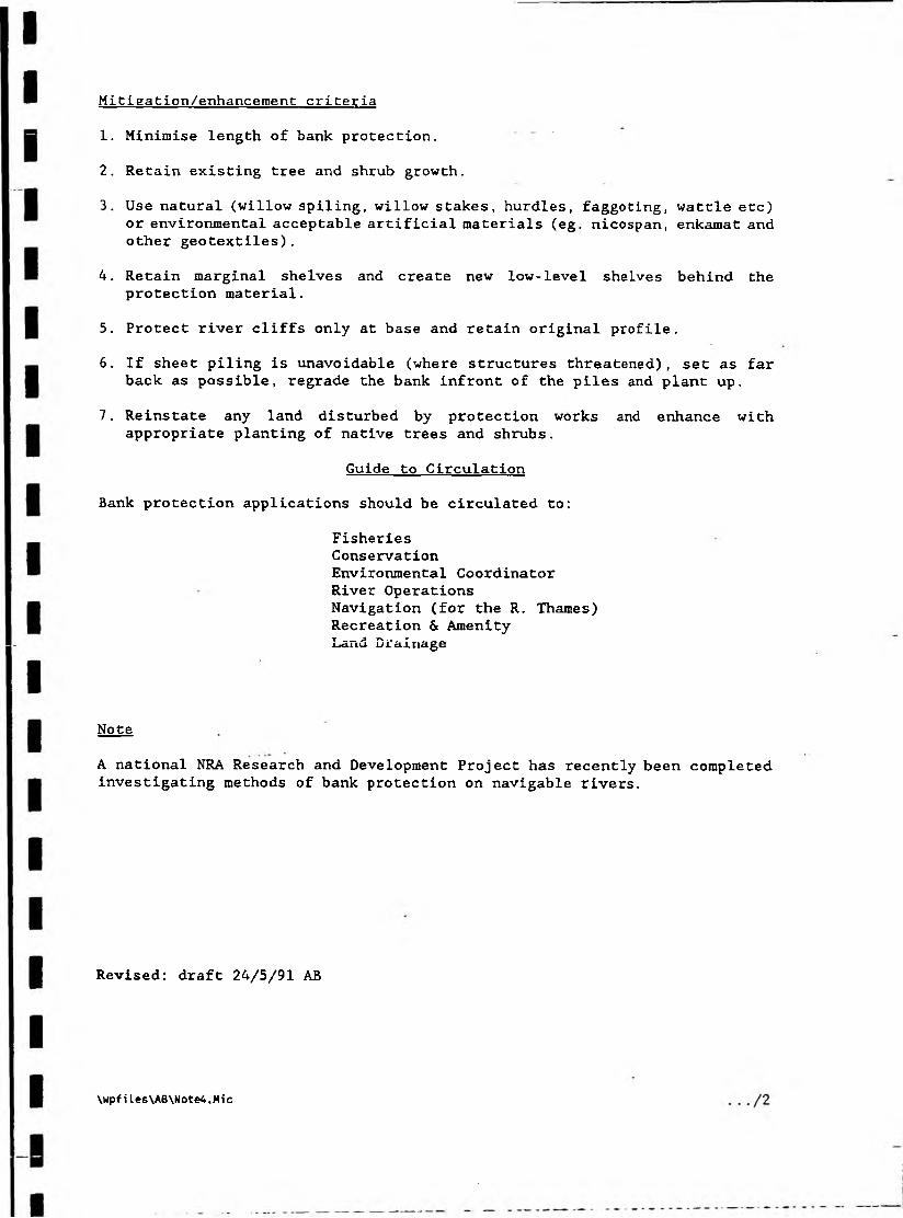
Mitigation/enhancement criteria
1. Minimise length of bank protection.2. Retain existing tree and shrub growth.
3. Use natural (willow spiling, willow stakes, hurdles, faggoting, wattle etc) or environmental acceptable artificial materials (eg. nicospan, enkamat and other geotextiles).
4. Retain marginal shelves and create new low-level shelves behind the protection material.
5. Protect river cliffs only at base and retain original profile.6. If sheet piling is unavoidable (where structures threatened), set as far
back as possible, regrade the bank infront of the piles and plant up.7. Reinstate any land disturbed by protection works and enhance with
appropriate planting of native trees and shrubs.Guide to Circulation
Bank protection applications should be circulated to:
FisheriesConservationEnvironmental CoordinatorRiver OperationsNavigation (for the R. Thames)Recreation & Amenity Land Drainage
Note
A national NRA Research and Development Project has recently been completed investigating methods of bank protection on navigable rivers.
Revised: draft 24/5/91 AB
\wpfiles\AB\Note4.Mic
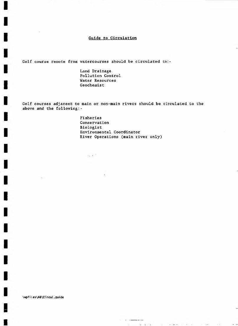
Guide to Circulation
Golf course remote from watercourses should be circulated to:Land Drainage Pollution Control Water Resources Geochemist
Golf courses adjacent to main or non-main rivers should be circulated to the above and the following:-
FisheriesConservationBiologistEnvironmental CoordinatorRiver Operations (main river only)
\wpfiles\AB\Circul.guide
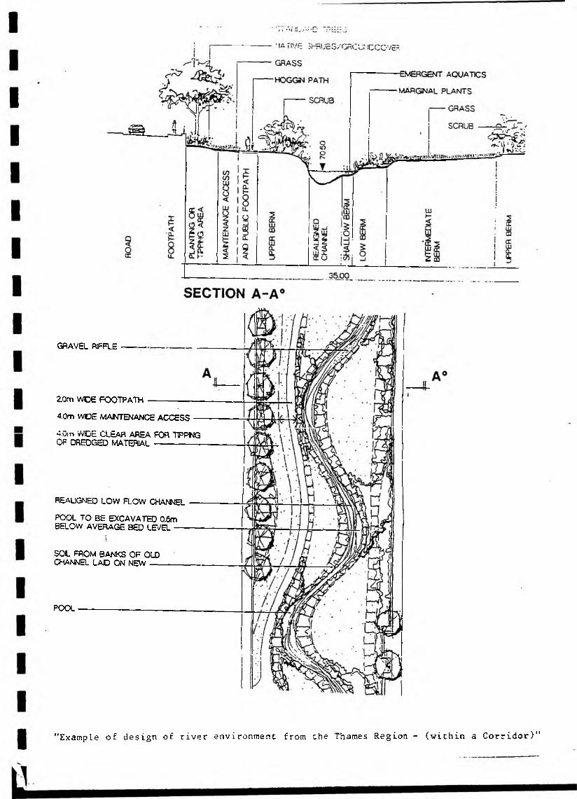
GRAVEL RIFFLE
2.0m WOE FOOTPATH
4.0m WDE MAINTENANCE ACCESS
H.utn WiuE CLEAR AREA FOR TFP1NG OF DREDGED MATERIAL
REALIGNED LOW FLOW CHANNEL
POOL TO BE EXCAVATED 0.6m BELOW AVERAGE BED LEVEL
SOL FROM BANKS OF OLD CHANNEL LAD ON NEW
POOL
"Example of design of river environment from the Thames Region - (within a Corridor)”
SSgGSBfiF**1*-'....... '
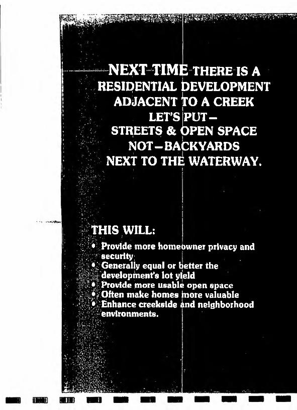
NEXT TIME THERE IS A RESIDENTIAL bEVELOPMENT
ADJACENT TO A CREEK LET'S [PUT -
STREETS & OPEN SPACE NOT-BACKYARDS
NEXT TO THE WATERWAY.
•THIS WILL:^ • Provide more homebwner privacy and
security;^'Generally equal or tetter the
development's lot yield Provide more usable open space Often make homes hiore valuable
:'|;^!-Enhance creekslde ind neighborhood environments.
‘ate {•“ '* 'I*

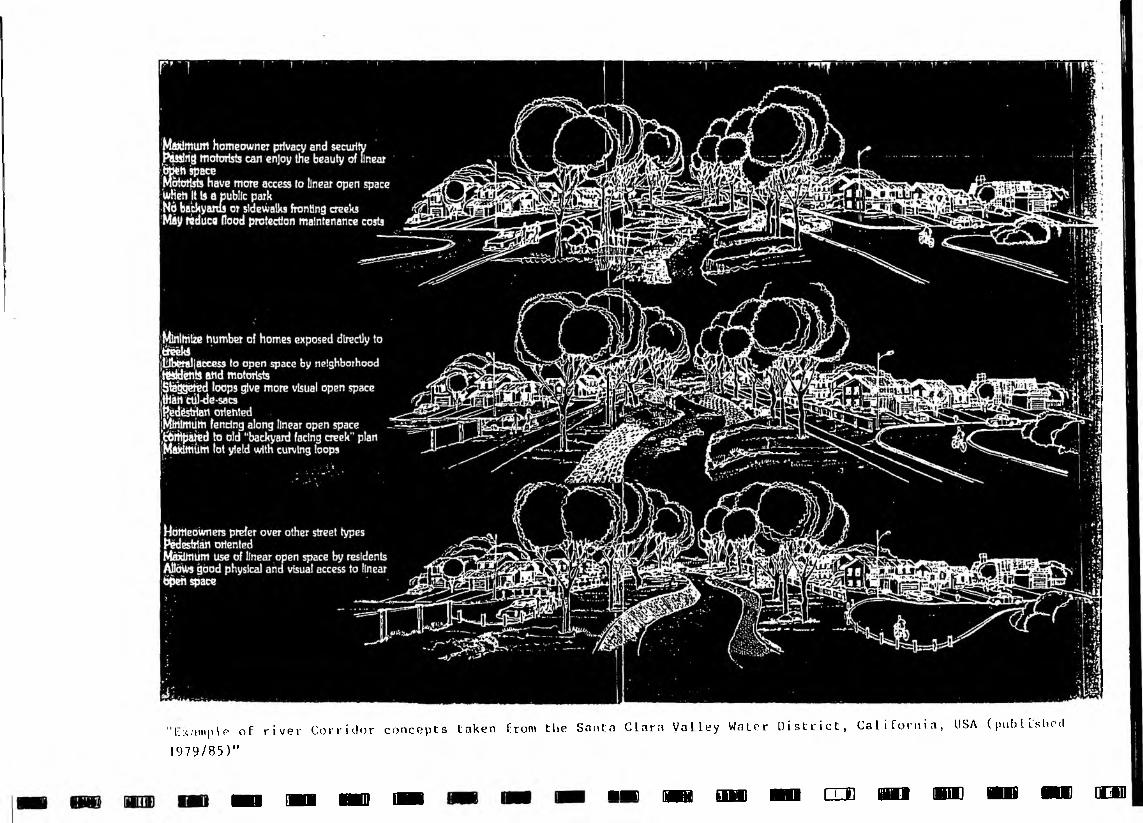
"tix.-implo of rivev Corridor concepts taken from the Santa Clara Valley Water District, California, USA (published 1979/85)"
■ n HB HO H i ■» m iDu n cm n o mn m m odb