technical manual for post-disaster rapid … · 6.1.3.12 clean-up buildings ... system for rapid...
TRANSCRIPT
OECS - ENVIRONMENT & SUSTAINABLE DEVELOPMENT UNIT
TECHNICAL MANUAL FOR POST-DISASTER RAPID ENVIRONMENTAL ASSESSMENT
VOLUME 1
MANUAL
(CONTRACT No. 2001.067CIDA)
April 4, 2003
Funding for this activity is provided by the Canadian International Development Agency (CIDA) th rough its Environmental Capacity Development (ENCAPD) Pro ject.
Supplementary funding relative to the work of the Disaster Management Specialist provided by the
Caribbean Development Bank (CDB) through its Disaster Mitigation Facility for the Caribbean.
The views expressed herein are those of the Authors and do not necessarily reflect the views of the Don or Agencies
supporting the Activity.
PREPARED BY
ECOENGINEERING CARIBBEAN LIMITED IN COLLABORATION WITH
DR. BARBARA CARBY, DISASTER MANAGEMENT SPECIALIST
62 EASTERN MAIN ROAD ST. AUGUSTINE
TRINIDAD, WEST INDIES
TELEPHONE: (868) 645 4420 FAX: (868) 662 7292
e-mail: [email protected]

COVER PHOTOGRAPHS COURTESY MR. PHILIP WARNER, SMITH WARNER INTERNATIONAL , KINGSTON, JAMAICA
TECHNICAL MANUAL FOR POST DISASTER RAPID ENVIRONMENTAL ASSESSMENT
VOLUME 1: MANUAL
i
TABLE OF CONTENTS
PREFACE……………………………………………………………………………………….v GLOSSARY…………………………………………………………………………………….vi LIST OF ACRONYMS…………………………………………………………………………xi
CHAPTER 1: INTRODUCTION ............................ .......................................................... 1
1.1. CONTEXT............................................................................................................ 1 1.2. THE DISASTER MANAGEMENT CYCLE .................................................................... 2
1.2.1 Stages in the Cycle.................................................................................... 2 1.2.2 Post-Disaster Assessments ....................................................................... 4
1.3. RAPID ENVIRONMENTAL ASSESSMENT .................................................................. 5 1.3.1 Definition.................................................................................................... 5 1.3.2 The REA Process ...................................................................................... 5 1.3.3 Before the Event ........................................................................................ 5 1.3.4 After the Event ........................................................................................... 7
1.3.4.1 Safety First! ........................................................................................ 7 1.3.4.2 Damage Assessment.......................................................................... 7 1.3.4.3 Environmental Protection.................................................................... 7
1.4. USING THIS MANUAL ............................................................................................ 7 1.4.1 Environmental Practitioners ....................................................................... 8 1.4.2 The Team Approach .................................................................................. 8 1.4.3 Disaster Management Areas ..................................................................... 8 1.4.4 Being Prepared.......................................................................................... 8 1.4.5 Response and Recovery............................................................................ 9 1.4.6 Rebuilding.................................................................................................. 9
CHAPTER 2: MAPPING AND DESCRIBING ENVIRONMENTAL ASS ETS ............... 10
2.1. SIGNIFICANT ENVIRONMENTAL ASSETS ............................................................... 11 2.1.1 Marine Environment................................................................................. 11
2.1.1.1 Corals ............................................................................................... 11 2.1.1.2 Seagrass Beds ................................................................................. 11 2.1.1.3 Fishing Grounds ............................................................................... 12
2.1.2 Coastal Features ..................................................................................... 12 2.1.2.1 Sandy Beaches ................................................................................ 12 2.1.2.2 Salt Ponds ........................................................................................ 12
2.1.3 Forests..................................................................................................... 12 2.1.4 Wetlands.................................................................................................. 13 2.1.5 Fresh Water Bodies ................................................................................. 13
2.1.5.1 Rivers, Streams and Ponds .............................................................. 13 2.1.5.2 Ground Water ................................................................................... 13
2.1.6 Historical and Archaeological Sites.......................................................... 13 2.2. MAPPING OF ASSETS ......................................................................................... 14
2.2.1 Coral Reefs.............................................................................................. 14

TECHNICAL MANUAL FOR POST DISASTER RAPID ENVIRONMENTAL ASSESSMENT
VOLUME 1: MANUAL
ii
2.2.2 Seagrass Beds ........................................................................................ 15 2.2.3 Fishing Grounds ...................................................................................... 15 2.2.4 Sandy Beaches........................................................................................ 15 2.2.5 Salt Ponds ............................................................................................... 15 2.2.6 Forests..................................................................................................... 16 2.2.7 Wetlands.................................................................................................. 16 2.2.8 Rivers, Ponds and Streams ..................................................................... 16 2.2.9 Ground Water .......................................................................................... 16 2.2.10 Historical and Archaeological Sites.......................................................... 16
2.3. DESCRIBING ASSETS ......................................................................................... 16 2.3.1 Overview.................................................................................................. 17 2.3.2 Corals ...................................................................................................... 17 2.3.3 Seagrass Beds ........................................................................................ 18 2.3.4 Fishing Grounds ...................................................................................... 21 2.3.5 Sandy Beaches........................................................................................ 21 2.3.6 Salt Ponds ............................................................................................... 21 2.3.7 Forests..................................................................................................... 22 2.3.8 Wetlands.................................................................................................. 22 2.3.9 Rivers, Streams and Ponds ..................................................................... 23 2.3.10 Ground Water .......................................................................................... 24 2.3.11 Historical and Archaeological Sites.......................................................... 24
2.4. FINANCIAL VALUING OF ASSETS.......................................................................... 24 2.4.1 Insurances ............................................................................................... 25 2.4.2 Replacement Cost ................................................................................... 25 2.4.3 Loss of Earnings ...................................................................................... 26 2.4.4 Loss of Investment................................................................................... 27 2.4.5 Willingness to Pay (Direct)....................................................................... 28 2.4.6 Willingness to Pay (Indirect) .................................................................... 28 2.4.7 Unit Rates ................................................................................................ 29 2.4.8 Choice of Method..................................................................................... 29
2.5. RANKING OF ASSETS ......................................................................................... 30 2.5.1 Ranking Criteria ....................................................................................... 30 2.5.2 “Red Flags” .............................................................................................. 30
CHAPTER 3:HUMAN-INDUCED HAZARDS .................... ........................................... 31
3.1. BULK FUEL STORAGE ........................................................................................ 32 3.2. EXPLOSIVES...................................................................................................... 32 3.3. AGROCHEMICALS .............................................................................................. 33 3.4. OTHER HAZARDOUS SUBSTANCES ...................................................................... 34 3.5. ASBESTOS ........................................................................................................ 34 3.6. PCBS............................................................................................................... 35 3.7. SUMMARY SHEETS ............................................................................................ 36
3.7.1 Preparation .............................................................................................. 36 3.7.2 Updating .................................................................................................. 36

TECHNICAL MANUAL FOR POST DISASTER RAPID ENVIRONMENTAL ASSESSMENT
VOLUME 1: MANUAL
iii
CHAPTER 4:OPERATIONAL PROCEDURES................... .......................................... 38
4.1. RESPONSE PROCEDURES .................................................................................. 38 4.1.1 Warning Phase ........................................................................................ 39 4.1.2 Activation ................................................................................................. 39 4.1.3 Response................................................................................................. 39 4.1.4 Rehabilitation ........................................................................................... 39
4.2 SAFETY FIRST! .................................................................................................. 40
CHAPTER 5:ASSESSMENT OF DAMAGE ..................... ............................................ 41
5.1. INITIAL REPORT ................................................................................................. 41 5.2. RAPID ASSESSMENT TOOL ................................................................................. 41
5.2.1 Rating Parameters................................................................................... 43 5.2.2 Intensity ................................................................................................... 43 5.2.3 Extent....................................................................................................... 44 5.2.4 Damage Assessment............................................................................... 44 5.2.5 Appropriate Intervention........................................................................... 44 5.2.6 Valuing Damage ...................................................................................... 45
5.2.6.1 Full Economic Loss........................................................................... 45 5.2.6.2 Remediation Cost ............................................................................. 46
5.2.7 Timing ...................................................................................................... 47 5.2.8 Scope of Inspections................................................................................ 47
5.3. TYPES OF DAMAGE ............................................................................................ 47 5.3.1 Coral Communities .................................................................................. 48 5.3.2 Seagrass Beds ........................................................................................ 50 5.3.3 Fishing Grounds ...................................................................................... 50 5.3.4 Sandy Beaches........................................................................................ 51 5.3.5 Salt Ponds ............................................................................................... 51 5.3.6 Forests..................................................................................................... 52 5.3.7 Wetlands.................................................................................................. 52 5.3.8 Rivers, Ponds and Streams ..................................................................... 53 5.3.9 Ground Water .......................................................................................... 53 5.3.10 Historical and Archaeological Sites.......................................................... 53 5.3.11 Summary of Results................................................................................. 54
CHAPTER 6: MEASURES TO MINIMIZE ENVIRONMENTAL DAMA GE .................. 56
6.1. BASIC CHECKLIST FORMAT ................................................................................ 56 6.1.1 Layout ...................................................................................................... 56 6.1.2 Example................................................................................................... 56 6.1.3 Typical Response/Recovery Activities ..................................................... 59
6.1.3.1 Establish Temporary Staging Areas ................................................. 59 6.1.3.2 Build Temporary Jetties .................................................................... 59 6.1.3.3 Build Emergency Helipad ................................................................. 59 6.1.3.4 Re-open/Repair Roads ..................................................................... 60 6.1.3.5 Clear/Reopen Runways.................................................................... 60 6.1.3.6 Restore Electricity/Telecommunications ........................................... 60
TECHNICAL MANUAL FOR POST DISASTER RAPID ENVIRONMENTAL ASSESSMENT
VOLUME 1: MANUAL
iv
6.1.3.7 Restore Water Supply....................................................................... 60 6.1.3.8 Build Temporary Accommodation..................................................... 60 6.1.3.9 Clear Water Courses ........................................................................ 60 6.1.3.10 Temporary Stabilization of Landslips ................................................ 61 6.1.3.11 Temporary Stabilization of Shorelines .............................................. 61 6.1.3.12 Clean-up Buildings............................................................................ 61 6.1.3.13 Demolition and Clearing of Damaged Structures.............................. 61 6.1.3.14 Vector Control................................................................................... 61 6.1.3.15 Containment and Collection of Contaminants On Land.................... 61 6.1.3.16 Containment and Collection of Contaminants In Water .................... 61
6.2. ALTERNATIVE FORMAT ....................................................................................... 62 6.2.1 Layout and Functions............................................................................... 62 6.2.2 Example................................................................................................... 62
6.3. TREATMENT AND DISPOSAL OF HAZARDOUS CHEMICALS AND CONTAMINATED
MATERIAL.................................................................................................................... 64
TECHNICAL MANUAL FOR POST DISASTER RAPID ENVIRONMENTAL ASSESSMENT
VOLUME 1: MANUAL
v
PREFACE
This Manual has been prepared as a resource document for Environmental and Disaster Response Agencies in the member-territories of the Organization of Eastern Caribbean Countries (OECS), for use in Post-Disaster situations. The objectives are:
i. to assess environmental damage caused by an adverse event, and
ii. to aid in addressing environmental concerns during activities undertaken in response to that event.
With regard to the former, this manual is intended to provide the assessment team with meaningful information on damage to the natural environment, based on a standardized approach. With regard to the latter, the manual seeks to ensure that activities undertaken in response to an event do not themselves create environmental problems. The manual is intended for use in Disaster Preparedness, Response and Recovery. It is envisaged, however, that the Rebuilding Stage will be informed by the damage assessments and environmental protection measures undertaken during the response and recovery stages respectively, but that normal environmental and planning controls will be reverted to during the Rebuilding Stage. This document is intended for use in situations of disasters due to natural and human phenomena, as well as situations where an event has caused some degree of damage but that damage may not be so extensive as to define the event as a “disaster”. The focus of the manual is the natural environment. This focus was chosen in recognition of the fact that the disaster response agencies in the OECS already address impacts on the human environment when preparing their response and recovery plans, so there is no need for duplication. The content of this Manual has been guided by the results of a survey of current (2002) practice with regard to environmental considerations in disaster response in the OECS [see R-1.1 in the Reference Notes, in Volume 2]. Volume 1 of this Manual consists of 6 chapters. The first chapter discusses the Disaster Management Cycle as it is presently applied in the OECS, introduces the concept of rapid environmental assessment (REA) and provides an overview on “Using this Manual@. Chapters 2 and 3 are relevant to the Preparedness Stage of the Disaster Management Cycle. Chapter 2 provides information on mapping and describing important components of the environment in the OECS, while Chapter 3 lists hazards. Chapters 4, 5, and 6 are relevant to the Response and Recovery Stages of the Disaster Management Cycle. Chapter 4 highlights operational procedures, while Chapter 5 presents a system for rapid assessment of damage caused by an adverse event. Finally, Chapter 6 lists steps which may be taken to minimize the possibility of environmental damage during response and recovery activities following an adverse event. Volume 2 of this manual contains forms, guidelines and reference notes, each in a separate Part with its own table of contents. The first Part includes forms for describing environmental assets, summarizing risk factors, assessing damage to environmental assets and identifying appropriate environmental protection measures for different activities. The other two Parts (Guidelines and Reference Notes) are arranged so that each sub-section aligns to a chapter in Volume 1. A Glossary is included in both volumes of this manual.
TECHNICAL MANUAL FOR POST DISASTER RAPID ENVIRONMENTAL ASSESSMENT
VOLUME 1: MANUAL
vi
GLOSSARY This Glossary contains definitions of terms used in the Technical Manual. Definitions were obtained from various sources which include references listed in Part III of Volume 2 of this Manual, and a Glossary of Environmental Terms prepared in 1997 for use by the OECS. Definitions for disaster management terms were obtained from Guidelines for Rapid Environmental Impact Assessment in Disasters prepared by the Benfield Greig Hazard Research Centre and CARE International and Field Reference Guide prepared by CDERA, OFDA and USAID. A few definitions were developed by Ecoengineering in the course of our work and in some cases, definitions have been adapted to make them specific to this Manual.
Abundance:
The number of individual specimens of an animal or plant. Adverse Event: An occurrence (natural or man-made) with potential to precipitate a disaster. Aquifer:
An underground geological formation, or group of formations, containing usable amounts of groundwater that can supply wells and springs.
Barrier Reefs:
These are reefs which are found fairly far away from the shore, usually with a lagoon formed in between the reef and the shore.
Baseline Condition:
The condition of an ecosystem/environmental asset before an adverse event occurs. Bioaccumulation:
The uptake and assimilation of persistent chemicals in the environment by living organisms. These chemicals may then accumulate in the living tissues of these organisms, thus moving up the food chain.
Bleaching:
A process by which corals expel their pigmented algal inhabitants and thus lose their colour, appearing white, the colour of their white limestone skeleton.
Berm:
An embankment which acts as a barrier between a lagoon or salt pond and the sea.
Bunker: A large container or compartment for storage purposes.
Coral:
Rock-like substance composed of the skeletons of dead polyps. Coral Polyps:
These are tiny, soft, transparent, flower-like animals which live together in groups or colonies.
TECHNICAL MANUAL FOR POST DISASTER RAPID ENVIRONMENTAL ASSESSMENT
VOLUME 1: MANUAL
vii
Delphi Technique: A technique for maximizing the reliability of the subjective judgments of a group of experts, using a planned programme of consecutive, iterative, individual interrogations interspersed with information feedback.
Disaster:
Any adverse event (natural or human-induced) which disrupts the basic fabric and normal functioning of a society or community, giving rise to casualties and/ or damage to property, infrastructure, essential services and means of livelihood on a scale which is beyond the capacity of the affected society to cope with without assistance.
Disaster Management :
A collective term encompassing all aspects of planning for and responding to disaster, including both pre- and post- disaster activities. It refers to both the risk and consequences of a disaster.
Disaster Management Cycle:
Disaster management can be seen as a series of phases on a time continuum. The Disaster Management Cycle is a six-stage system on this continuum, designed for effectively managing disasters by relying on preventative, mitigatory and post-disaster measures.
Damage Assessment:
The preparation of specific, quantified estimates of physical and economic damage resulting from a disaster.
Disaster Mitigation:
Measures taken to reduce the loss of life, livelihood and property by hazards and disasters, either by reducing vulnerability or by modifying the hazard where possible.
Disaster Preparedness:
Actions taken in advance of a disaster to minimize loss of life and damage, organize temporary removal of people and property from a threatened location, and facilitate timely and effective rescue and relief rehabilitation after the disaster.
Disaster Prevention:
Measures taken to prevent hazards from giving rise to disasters.
Disaster Response/Relief: Actions intended to save lives, alleviate suffering and provide basic care in the immediate aftermath of a disaster.
Diversity:
Richness of the number of species.
Elfin Woodland: The type of vegetation usually encountered above 2,000 feet in elevation. It is generally short and wind-deformed and usually laden with mosses and epiphytes and matted with lianas.
Environmental Asset:
A valued feature of the natural or human environment. Eutrophication:
The extreme growth of algae in a water body due to the presence of high concentrations of nutrients (nitrates, phosphates, etc).

TECHNICAL MANUAL FOR POST DISASTER RAPID ENVIRONMENTAL ASSESSMENT
VOLUME 1: MANUAL
viii
Fish Kill: Where masses of fish and other aquatic life (freshwater or marine) are killed, usually as a result of pollution.
Fringing Reefs:
These reefs grow out from the shores of the land masses where the water is shallow. Fumarole:
A small hole in the earth’s crust near a volcano from which gases, smoke or steam are released.
Groundwater: Water which is held in soil or in porous rock and which may be prevented from downward movement by an impermeable layer of rock beneath.
Hazard: A potentially damaging phenomenon, whether natural or man-induced whose presence increases the probability of damage to life, health, property or the environment.
Hazardous Substance/ Material:
Any substance or material which may be classified into one of the following categories: toxic, corrosive, flammable, explosive or infectious.
Initial Damage Assessment (IDA):
An assessment usually carried out within the first 48 hours after the impact of a hazard, by trained evaluators, to obtain an initial evaluation of the damage to each sector.
Invasive Species:
An invasive species is one which after introduction, begins to out-compete the existing/native species.
Lagoon: A shallow part of the sea in the tropics, surrounded or almost surrounded by reefs.
Lens:
A layer of water which sits atop another layer of water, e.g. a layer of fresh water may be found floating on a more dense layer of salt water.
Littoral Woodland :
Salt spray tolerant vegetation which occurs near the coastline, where tree growth is asymmetrical due to the onslaught of sea breezes.
Mangrove:
A generic term used to describe a group of woody, salt tolerant plants that grow along sheltered tropical and sub-tropical coasts.
Material Safety Data Sheet:
This is a standard document provided by chemical manufacturers, which lists important information concerning the health, safety and environmental characteristics of the product being sold.
Montane Rain Forest:
Found above elevations where rainforest vegetation is found but below mountain peaks and ridges. Montane Thicket:
The type of vegetation which occurs at elevations of approximately 3,500 feet.
TECHNICAL MANUAL FOR POST DISASTER RAPID ENVIRONMENTAL ASSESSMENT
VOLUME 1: MANUAL
ix
Mossing: The increased growth of mosses and algae which covers substrate and corals in hyper-nutrified waters often associated with sewage contaminated waters. See Eutrophication.
Natural Forest:
Native forest which has not been altered. Patch Reefs:
These are isolated patches of reef on parts of the sea floor that rise close to the surface.
Plantation Forest: Forest which has been cultivated for commerce, usually with a single species.
Polychlorinated Biphenyls (PCB’s):
A group of compounds, formed by chlorination of a biphenyl compound. They are known carcinogens and may be toxic and persistent.
Post-Disaster:
Period following a disaster event, whether natural or human-induced. Rain Forest:
A large, dense forest in a hot, humid region (tropical or subtropical), usually found above 1,000 feet in areas of abundant precipitation.
Rapid Environmental Assessment:
An assessment which is carried out in the period immediately following a disaster to determine the degree of damage suffered and the appropriate response.
Rebuilding/Reconstruction:
The medium to long term repair of physical, social and economic damage and the return of affected communities to a condition equal to or better than before a disaster. This is usually undertaken after a period of rehabilitation and normally involves significant construction extending for several months or even years following an adverse event.
Recovery/Rehabilitation:
Short-term actions such as restoration of basic services undertaken after the immediate threat has passed, intended to bring life back to normal. This may be typically completed within 10-12 weeks of the disaster event.
Relief:
see Disaster Response/Relief. Response:
see Disaster Response/Relief. Rhizome:
Plant stem which lies underground and contains leaf buds (as opposed to a root which lies underground but is not a stem).
Risk Factor: see Hazard.

TECHNICAL MANUAL FOR POST DISASTER RAPID ENVIRONMENTAL ASSESSMENT
VOLUME 1: MANUAL
x
Salt Pond: An enclosed saltwater body found near to the sea formed by the barring off of part of the sea by a berm in which salinity may be highly elevated due to evaporation and fluctuations are great.
Sand Dunes: These are waves of drifting sand, the height and movement of which are determined by the direction and intensity of the wind; they may form small hills or ridges, or crescents in the desert and may be covered with sparse grass near the sea.
Sand Migration:
The movement of sand along the sea bed, beaches or coastlines by wave or wind action. Scouring:
The erosion or removal of material by the action of running water Sea Grass:
True flowering marine plants found in clear, shallow sea waters, which grow prolifically via runners with emergent shoots.
Sea Grass Beds:
The marine habitat which supports sea grasses. Secondary Containment:
An enclosure surrounding a primary containment vessel, which prevents dispersal of the material being stored in the event of a rupture to the primary containment vessel.
Secondary Forest:
Forest which has grown back in areas where the original forest has been cleared or logged. Scrub Woodland:
The type of vegetation which occurs downslope of secondary rainforest vegetation. Smothering:
The covering up of sea bed communities (corals, sea grass beds, etc.) by the deposition of particulate matter (silt, ash, etc.) which cuts off the light to these communities required for their survival.
Spill Containment:
The process by which spills are contained within a given area. See Secondary Containment. Staging Area:
A safe, clear area where resources (persons, equipment, supplies, etc.) are gathered and from which they are mobilized, following a disaster.
Tank Farm:
A collection of storage tanks within an area. Wetlands:
Areas of marsh, fen, peatland or water, whether natural or artificial, permanent or temporary, with water that is static or flowing, fresh, brackish or salt, including areas of marine water the depth of which at low tide does not exceed six metres.
TECHNICAL MANUAL FOR POST DISASTER RAPID ENVIRONMENTAL ASSESSMENT
VOLUME 1: MANUAL
xi
LIST OF ACRONYMS
CDERA Caribbean Disaster and Emergency Response Agency DSA Detailed Sector Assessment EOC Emergency Operations Center IDA Initial Damage Assessment ISO International Standards Organisation NEOC National Emergency Operations Center NGOs Non-governmental Organizations OFDA Office of Foreign development Assistance OECS Organization of Eastern Caribbean States REA Rapid Environmental Assessment USAID United States Agency for International Development

TECHNICAL MANUAL FOR POST DISASTER RAPID ENVIRONMENTAL ASSESSMENT
VOLUME 1: MANUAL
1 of 63
CHAPTER 1: INTRODUCTION
This chapter consists of four parts:
< a discussion which places the REA process in the context of disaster management,
< a discussion of the Disaster Management Cycle, < an introduction to the concept of Rapid Environmental Assessment, and < an overview of using this manual.
It is intended to place the use of the manual in the context of other response and recovery activities following an adverse event in the OECS.
1.1. Context This manual is intended for use in the member countries of the Organization of Eastern Caribbean States. It is therefore useful to start with a brief overview of the way that disaster management is organized in the OECS, as the Rapid Environmental Assessment (REA) will have to harmonize with the existing disaster management system if it is to be effective. The National Disaster Management Organization in most OECS Countries consists of:
� A National Disaster Committee , chaired by the Prime Minister;
� A National Disaster Management Office , led by the National Disaster Co-ordinator; and
� Various Sub-Committees with responsibility for different functional areas such as
Response & Relief, Health & Welfare, Damage Assessment or Mitigation. These committees are comprised of public sector agencies, as well as NGOs. The REA Team should be members of the Environmental Management, Damage Assessment and/or Mitigation Sub-committees. The present Terms of Reference of these sub-committees will have to be amended to include the application of the REA. Because these sub-committees are responsible for national disaster programmes, such an amendment will help to institutionalize the REA Process. Further actions needed to incorporate the REA Process into the National Disaster Management System are discussed in the Guidelines to this Manual [See Section G-1 of the Guidelines].
TECHNICAL MANUAL FOR POST DISASTER RAPID ENVIRONMENTAL ASSESSMENT
VOLUME 1: MANUAL
2 of 63
1.2. The Disaster Management Cycle
≡
Successful disaster management requires adequate at tention to all stages of the Disaster Management Cycle. Disasters provide a wind ow of opportunity for preventing future disasters or reducing their impact. Adequat e preparation before the onset of a disaster is critical to successful response. A re sponse system which relies exclusively on actions to be taken after the disaster event is unlikely to be effective.
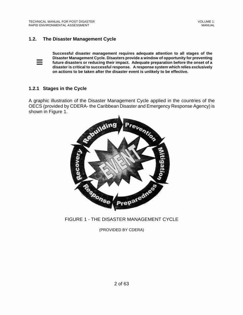
1.2.1 Stages in the Cycle A graphic illustration of the Disaster Management Cycle applied in the countries of the OECS (provided by CDERA- the Caribbean Disaster and Emergency Response Agency) is shown in Figure 1.
FIGURE 1 - THE DISASTER MANAGEMENT CYCLE
(PROVIDED BY CDERA)
TECHNICAL MANUAL FOR POST DISASTER RAPID ENVIRONMENTAL ASSESSMENT
VOLUME 1: MANUAL
3 of 63
The Disaster Management Cycle in Figure 1 includes a total of six stages, three of which precede the disaster event:
<<<< Prevention, <<<< Mitigation, and <<<< Preparedness.
The remaining three stages follow the disaster event:
<<<< Response, <<<< Recovery, and < Rebuilding.
The six stages of disaster management may be briefly described as follows:
< Prevention describes actions taken to eliminate the possibility of a hazard becoming a disaster.
< Mitigation describes actions taken to reduce the effects of a hazard or disaster.
< Preparedness describes actions taken in advance of a disaster which ensure
timely, appropriate and effective organisation and delivery of relief and assistance following a disaster. Effective disaster preparedness planning should consider recovery needs as well as response needs.
< Response describes actions intended to safeguard life and limb in the immediate
aftermath of a disaster (eg: first aid, emergency medical care, shelter, temporary relocation, etc). Typically, in the West Indies in 2002, this stage of the disaster management cycle is expected to be completed within 2 weeks [see Reference Note 1.2].
< Recovery describes actions undertaken after the immediate threat has passed and
intended to bring life back to normal (eg: clean-up, restoration of utilities, etc). Typically, in the West Indies in 2002, this stage of the disaster management cycle is expected to be completed within 10 weeks [see Reference Note 1.2].
< Rebuilding describes actions which normally involve significant construction and
may extend for a period of months (or even years) after the disaster [see Reference Note 1.2].
TECHNICAL MANUAL FOR POST DISASTER RAPID ENVIRONMENTAL ASSESSMENT
VOLUME 1: MANUAL
4 of 63
1.2.2 Post-Disaster Assessments Assessing the damage which has been occasioned by a disaster or an adverse event is an important first step in response. According to CDERA (CDERA/OFDA/USAID), there are three main types of assessments which are carried out following a disaster or adverse event:
< Initial Situation Overview, < Initial Damage Assessment, and < Detailed Sector Assessment.
These are briefly described below.
• The Initial Situation Overview (ISO) is typically carried out within the first 8 hours of a disaster, often by aerial reconnaissance, to obtain rapidly a broad picture of the extent of the damage suffered. It focuses on casualties, displacement of the population and damage to lifelines and critical facilities. The ISO is based on general reconnaissance rather than on detailed field assessment and the information allows national officials to determine immediate actions necessary to respond to the effects of the event.
• The Initial Damage Assessment (IDA) is typically carried out and completed within the first
48 hours following a disaster to obtain an initial evaluation of the damage suffered. It is conducted by trained evaluators who classify and record the extent of damage to items or structures (bridges, houses, etc.), using pre-defined criteria. The information which is gathered from the IDA can be used by authorities at the local, district or national level to determine priority needs, requirements for short-term assistance, and preparation of an initial estimate of the cost of the disaster. It is envisaged that the application of the REA process will start during the IDA.
• The Detailed Sector Assessment (DSA) is typically carried out following the first 48 hours
after the disaster has occurred and can last several weeks. It is carried out by sector specialists (for example, engineers, economists, agricultural extension officers, etc.) To obtain a more detailed and accurate evaluation and economic cost of the damage suffered. The information collected in the DSA is used to determine the overall economic impact of the disaster; recovery and rehabilitation needs; types of long-term assistance required; and types of action required to minimize damage from future events. The application of the REA process which started during the IDA is expected to continue during the DSA.

TECHNICAL MANUAL FOR POST DISASTER RAPID ENVIRONMENTAL ASSESSMENT
VOLUME 1: MANUAL
5 of 63
1.3. Rapid Environmental Assessment
≡
Rapid Environmental Assessment tools are particular ly useful in circumstances like post disaster situations, where it is impractical t o undertake extensive data-collection and analysis.
1.3.1 Definition The World Health Organization (Economopoulos, 1993) has suggested that the rapid assessment concept is useful:
< In countries where there is limited availability of human resources, < For making an initial appraisal of a situation, and < In the design of environmental control strategies and policies.
In disaster management, an initial assessment of the damage caused by an adverse event is required within forty-eight hours of the event. The information collected during this initial appraisal is used to guide response and recovery activities in the aftermath of the adverse event. The efficient and timely completion of this exercise therefore depends heavily on the application of rapid assessment procedures. It is within this context that the rapid environmental assessment (REA) tool described in this manual has been developed. As mentioned before, this REA focuses on the natural (physical and biological) environment since disaster response agencies in the OECS already address impacts on the human environment when preparing their response and recovery plans.
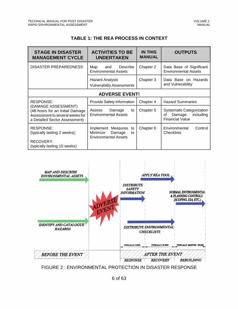
1.3.2 The REA Process Figure 2 provides an overview of the Rapid Environmental Assessment Process as it is envisaged in this manual. In addition, Table 1 places the rapid environmental assessment (REA) process into the context of the disaster management cycle and the layout of this Manual. The REA process begins during the preparedness stage and follows through into the response and recovery stages. The process is further explained in the sections below.
1.3.3 Before the Event Disaster Preparedness requires a broad understanding of the environment (both natural and human) in which the damage assessment and response and recovery teams will be called upon to operate. The process therefore requires the cataloguing of significant environmental assets and hazards for each disaster management area. This includes the identification and mapping of environmental assets, describing the condition of those assets and assigning financial values, and the identification and description of hazards. It is expected that this information will be updated periodically, to reflect changes in the condition of assets or the location and type of hazards.
TECHNICAL MANUAL FOR POST DISASTER RAPID ENVIRONMENTAL ASSESSMENT
VOLUME 1: MANUAL
6 of 63
TABLE 1: THE REA PROCESS IN CONTEXT
STAGE IN DISASTER
MANAGEMENT CYCLE
ACTIVITIES TO BE
UNDERTAKEN
IN THIS
MANUAL
OUTPUTS
Map and Describe Environmental Assets
Chapter 2
Data Base of Significant Environmental Assets
DISASTER PREPAREDNESS
Hazard Analysis
Vulnerability Assessments
Chapter 3
Data Base on Hazards and Vulnerability
ADVERSE EVENT!
Provide Safety Information
Chapter 4
Hazard Summaries
RESPONSE: (DAMAGE ASSESSMENT) (48 hours for an Initial Damage Assessment to several weeks for a Detailed Sector Assessment)
Assess Damage to Environmental Assets
Chapter 5
Systematic Categorization of Damage, including Financial Value
RESPONSE: (typically lasting 2 weeks); RECOVERY: (typically lasting 10 weeks)
Implement Measures to Minimize Damage to Environmental Assets
Chapter 6
Environmental Control Checklists
FIGURE 2 : ENVIRONMENTAL PROTECTION IN DISASTER RESPONSE
TECHNICAL MANUAL FOR POST DISASTER RAPID ENVIRONMENTAL ASSESSMENT
VOLUME 1: MANUAL
7 of 63
1.3.4 After the Event
1.3.4.1 Safety First!
Once an adverse event has occurred, the damage assessment and response and recovery teams need to be aware of risks to which they might be exposed. It is therefore important to provide these teams with summaries of the hazards identified during the Preparedness Stage. The objective is to ensure that response personnel remain effective in that role and do not join the ranks of the victims. This is intended to supplement, but not to replace parallel efforts by specialist agencies like the Fire Department.
1.3.4.2 Damage Assessment The first step following an adverse event is to assess the situation. This is a normal task of disaster response agencies, but (until now) has not included an assessment of environmental effects. The process includes a tool for rapid, systematic assessment of damage to the environment, based on field observations. The system relies on the descriptions of environmental assets prepared prior to the event, and will only be effective if that preparation has been properly done.
1.3.4.3 Environmental Protection
During the actual response and recovery effort, it is necessary to take steps to safeguard the environment from damage consequent upon those activities. The process includes a method of identifying environmental safeguards based on a checklist format. Different checklists have been developed for specific activities, and within each checklist the protection measures have been sorted according to specific environmental components.
1.4. Using this Manual
≡
The design of this manual assumes that environmenta l practitioners will be fully integrated into the disaster management team.

TECHNICAL MANUAL FOR POST DISASTER RAPID ENVIRONMENTAL ASSESSMENT
VOLUME 1: MANUAL
8 of 63
1.4.1 Environmental Practitioners The application of this manual is expected to be the responsibility of environmental practitioners in the various countries of the OECS. The term “environmental practitioners” is used here to describe persons who have had a basic level of training in environmental science, engineering or management at the post-secondary level (technical or professional level), and whose day-to-day work involves some aspect of the natural environment. In the OECS, this runs the gamut from foresters and fishery officers to environmental management officers and public health inspectors. The focus is not so much the level of academic attainment, but rather a broad appreciation of environmental concerns in the home country and/or sectoral specialization.
1.4.2 The Team Approach This manual is intended to assist the entire team which is involved in disaster management in each country of the OECS. It is not envisaged that the environmental practitioners will function as a separate but parallel group. Instead, it is expected that the environmental practitioners will provide specialist inputs which will contribute to a common effort.
1.4.3 Disaster Management Areas In the OECS, disaster management is normally organized at the local level, with each country being divided into different management areas. It is expected that the work in this manual will also be organized along the same lines.
1.4.4 Being Prepared One of the most important lessons learned during the research for this assignment is that the Assessment of Damage and other Response and Recovery actions are unlikely to be successful unless there is adequate preparation prior to the adverse event. This manual therefore identifies information which must be collected ahead of an event, which will be used during the Response and Recovery stages. For efficiency, it is likely that this information will be developed by specialist sectoral agencies for each country as a whole, and then disaggregated to the different disaster management areas.

TECHNICAL MANUAL FOR POST DISASTER RAPID ENVIRONMENTAL ASSESSMENT
VOLUME 1: MANUAL
9 of 63
1.4.5 Response and Recovery After an event, the thrust of this manual is three-fold:
First, it provides a mechanism by which safety information can be disseminated to the personnel who will go into the field to assess damage or to undertake response activities.
Second, this manual provides a rapid, systematic approach for assessing damage to the natural environment occasioned by the event.
Third, this manual provides a simple method (based on checklists) for identifying measures which may be taken to protect the environment during response and recovery activities.
It is expected that each of these activities will be undertaken by the environmental practitioners, and delivered to the local area disaster management co-ordinator or the national disaster management co-ordinator.
1.4.6 Rebuilding While there can be no doubt that the damage assessments and environmental protection checklists which are undertaken/prepared during the response and recovery stages will inform the work of rebuilding, this manual is not intended to replace more formal environmental controls during the Rebuilding Stage. Instead, it assumes that the Rebuilding Stage of the disaster management cycle will be subject to the normal environmental/ planning controls in each territory, specifically:
i scoping of the rebuilding action, to determine whether an Environmental Impact Assessment (EIA) is required, and
ii undertaking the EIA if one is needed.
TECHNICAL MANUAL FOR POST DISASTER RAPID ENVIRONMENTAL ASSESSMENT
VOLUME 1: MANUAL
10 of 63
CHAPTER 2: MAPPING AND DESCRIBING ENVIRONMENTAL ASSETS
This chapter focuses on mapping and describing significant environmental assets in the OECS, in advance of adverse events. Specifically, it discusses:
i Significant Environmental Assets in the OECS, ii Mapping of Assets, iii Describing Assets, iv Financial Valuing of Assets and v Ranking of Assets.
As will be discussed later, the location and pre-disaster condition of these assets will guide the Environmental Officer(s) on the disaster response team in assessing environmental damage. Mapping and describing environmental assets is not to be considered as a one-time effort. Rather, it must be approached as an on-going activity requiring periodic updates. The frequency of re-evaluation will differ depending on the type of asset, but in general the period between updates should not exceed 5 years. An important aspect of development of national disaster plans is a data base containing the resources available for disaster management. Traditionally, this data base contains resources available for response and recovery operations. Thus, transport equipment, shelters, communications equipment, relief supplies, etc are listed. Once a country’s environmental assets have been mapped and described, however, they should be added to the resource base. This will make them part of the information available in the NEOC. It should be noted that the description, mapping and valuing of environmental assets will also be useful should litigation be considered after, say, an oil spill, when the polluter may be required to pay for damage incurred.
TECHNICAL MANUAL FOR POST DISASTER RAPID ENVIRONMENTAL ASSESSMENT
VOLUME 1: MANUAL
11 of 63
2.1. Significant Environmental Assets The following significant environmental assets have been identified within the OECS and are briefly introduced in the sections below.
< Marine Environment: Corals Sea Grass Beds Fishing Grounds and nurseries
< Coastal Features Sandy Beaches
Salt Ponds < Forests
< Wetlands (mainly Mangroves)
< Fresh Water Bodies Rivers, Streams and Ponds
Ground Water In addition to the assets listed above, it is recommended that one component of the human environment should be included:
< Historical and Archaeological Sites.
2.1.1 Marine Environment
2.1.1.1 Corals Coral communities [see Reference Note 2.1] are formed by the activity of coral polyps (invertebrate animals), and the resulting communities may be soft or stony. Corals are typically found in warm, shallow, clear, clean water and grow best where there is constant movement of water around them. Large coral communities are called coral reefs, which take different forms. Barrier reefs occur off the coast, fringing reefs occur along the shoreline and patch reefs occur in the lagoons between the barrier and the shore.
2.1.1.2 Seagrass Beds Seagrass beds [see Reference Note 2.2] are often (but not exclusively) found in relatively close proximity to coral communities. They are usually present in shallow (less than 20m) areas of the coastal zone. Seagrasses have extensive interwoven underground creeping stems with roots attached. These stems are called rhizomes. Caribbean seagrass beds are typically a mixed association with broad-bladed turtle grass predominating with various
TECHNICAL MANUAL FOR POST DISASTER RAPID ENVIRONMENTAL ASSESSMENT
VOLUME 1: MANUAL
12 of 63
stands of finer manatee and shoal grasses.
2.1.1.3 Fishing Grounds There are important commercial as well as recreational fisheries throughout the OECS, some of which are associated with coral communities and seagrass beds [see Sections 2.1.1.1 and 2.1.1.2, above]. Other fishing grounds may be associated with submerged rocks which provide shelter for marine animals and points of attachment for marine plants.
2.1.2 Coastal Features
2.1.2.1 Sandy Beaches Sandy beaches are areas of high stress and constant motion of beach sand. They are usually backed by sand dunes (waves of drifting sand) which are stabilized by shifting dune plants. Behind the shifting dunes are stable dunes characterized by heavier vegetation. The sand found on beaches in the OECS may either be black volcanic, white calcareous or yellow sand.
2.1.2.2 Salt Ponds Most salt ponds [see Reference Note 2.3] are isolated former bays or parts of a bay that have become closed by reef or mangrove growth across the bay. The characteristic high salinity (ranging from 115 to 180 ppt) results from high evaporation of runoff waters which are then stirred by winds, keeping the sediments in suspension. Salt ponds were once of commercial importance in the West Indies for the production of salt, but this use has diminished. Several salt ponds have been either filled in for built development, or dredged out for marina development.
2.1.3 Forests Forests in the OECS Territories [see Reference Note 2.4] comprise natural forest, secondary forest and plantation forest. Much of the natural forest on the islands has historically been cleared for agriculture and built development. However, there are still areas of natural forest, including rain forest, montane thicket, and elfin woodland in areas of high rainfall; montane rain forest in well drained areas of intermediate elevation and moderate rainfall; littoral woodland which occurs near the coast; and scrub woodland which occurs in dry areas. Unique vegetative types, such as fumarole vegetation in the Valley of Desolation in Dominica, also occur. In some areas, secondary vegetation has sprung up in areas where agriculture has been abandoned. In other areas, plantation forests have been planted. Secondary forest is
TECHNICAL MANUAL FOR POST DISASTER RAPID ENVIRONMENTAL ASSESSMENT
VOLUME 1: MANUAL
13 of 63
usually a mix of native species, but forest plantations consist largely of a monoculture of native or introduced species such as cedar, mahogany, blue mahoe, and Caribbean pine.
2.1.4 Wetlands Wetlands are lands which are transitional between terrestrial and aquatic systems, where the water table is usually at or near the surface or the land is covered by shallow water. Wetlands can be permanent, temporary or seasonal, with static or flowing water which may be fresh, brackish or salt. Many wetlands in the OECS consist of mangrove [see Reference Note 2.5]. Red mangrove tends to be more abundant along the lowest, more flooded areas. Black mangrove tends to thrive on the mud of the slightly higher elevations. White mangrove may be scattered among the black mangrove and extending to drier (and often higher) ground. Buttonwood may be abundant along the inland border of the swamps. In the Eastern Caribbean, the steep shorelines of high islands, the limited freshwater runoff of low dry islands and the exposure of a large portion of the shorelines to powerful waves impose limits on mangrove development. Here mangroves develop in small sheltered pockets at protected river mouths or fringing the most sheltered shoreline areas.
2.1.5 Fresh Water Bodies
2.1.5.1 Rivers, Streams and Ponds Natural bodies of surface water in the OECS Territories include rivers, streams and inland ponds. These serve the dual purpose of drainage and water supply. Rivers and streams in some islands may begin at high elevations, and they flow seaward along natural drainage channels.
2.1.5.2 Ground Water Ground water reserves develop when rain water or surface water infiltrates into the ground and collects in porous rock formations (aquifers). Because ground water reserves are less susceptible to evaporation than surface water bodies, they represent a more consistent water source over the changing seasons. The nature of fresh water reserves in the ground varies from aquifers of substantial thickness to very thin lenses overlaying salt water.
2.1.6 Historical and Archaeological Sites In addition to the components of the natural environment listed above, it is recommended that one component of the human environment (historical and archaeological sites) should
TECHNICAL MANUAL FOR POST DISASTER RAPID ENVIRONMENTAL ASSESSMENT
VOLUME 1: MANUAL
14 of 63
also be considered. The OECS Territories possess a rich historical and archaeological heritage which should be preserved for future generations. Historical sites include sugar mills, military structures, wind mills, colonial buildings, plantation sites, vernacular architecture, churches, historic towns and villages, shipwrecks, and cemeteries. Archaeological sites date to the Pre-Columbian period and consist of Amerindian remains.
2.2. Mapping of Assets The locations of all of the significant environmental assets listed in Section 2.1, should as far as practical be mapped. This will allow quick identification of environmental assets located within an adverse event area. The following sections list some of the sources of information for producing these maps. If resources are not available for mapping of assets, a simple listing of such assets is a good first step (with mapping to be done later when resources become available).
2.2.1 Coral Reefs Information on the location of coral communities can be obtained from the following sources:
< Ordinance Survey Maps show the location of coral communities close to the shoreline, and also show large coral communities (reefs) further offshore.
< The Fisheries Department normally has information on the location of
important coral communities, particularly those which are breeding-grounds for commercially-important fish species.
< Dive shop and tourist boat operators also have information on the location of
coral communities.
< Commercial and sport fishermen can usually provide some information on the location of coral communities.
TECHNICAL MANUAL FOR POST DISASTER RAPID ENVIRONMENTAL ASSESSMENT
VOLUME 1: MANUAL
15 of 63
2.2.2 Seagrass Beds Information on the location of seagrass beds can be obtained from the following sources:
< The Fisheries Department normally has information on the location of important seagrass beds, particularly those which are breeding-grounds for commercially-important fish species.
< Dive shop and tourist boat operators also have information on the location of
seagrass beds.
< Commercial and sport fishermen can usually provide some information on the location of seagrass beds.
2.2.3 Fishing Grounds Information on the location of fishing grounds is more difficult to come by, as commercial and recreational fishermen jealously guard these locations from competitors. However, some information may be gained from:
< The Fisheries Department normally has information on the location of important fishing grounds for commercially-important fish species.
< Dive shop and tourist boat operators and fishermen may release limited
information on the location of fishing grounds if they understand the use to which this information will be put.
2.2.4 Sandy Beaches Sandy beaches are very easy to identify. They are generally shown on Ordinance Survey maps, and can also be easily located through field reconnaissance. In many OECS Territories, specific sandy beaches are nesting grounds for marine turtles. These species are all listed as endangered, and special conservation efforts are in place region-wide. The Fisheries Department and some naturalist groups will be able to identify turtle nesting beaches, and these should be clearly identified on your list or map.
2.2.5 Salt Ponds Salt ponds are generally shown on Ordinance Survey maps, and their status (functioning or
TECHNICAL MANUAL FOR POST DISASTER RAPID ENVIRONMENTAL ASSESSMENT
VOLUME 1: MANUAL
16 of 63
non-functional) can also be verified through field reconnaissance.
2.2.6 Forests Forests are another environmental component which are relatively easy to identify. They are generally shown on Ordinance Survey maps, and can also be easily located through field reconnaissance. However, it may be necessary to seek the assistance of the Forestry Department to differentiate between different forest types.
2.2.7 Wetlands Like forests, wetlands are relatively easy to identify. They are generally shown on Ordinance Survey maps, and can also be easily located through field reconnaissance. Again, though, it may be necessary to seek the assistance of the Forestry Department and the Fisheries Department to determine the relative significance of different wetlands.
2.2.8 Rivers, Ponds and Streams These features are shown on Ordinance Survey Maps. However, information should be sought from the Water Supply Utility to identify intakes and catchment areas for the public water supply.
2.2.9 Ground Water Information on ground water reserves may be obtained from the Water Supply Utility. In mapping these reserves, it is important to show the full extent of unconfined aquifers, and the recharge areas for confined aquifers.
2.2.10 Historical and Archaeological Sites Some historical and a few archaeological sites are shown on Ordinance Survey Maps. Additional information can be obtained from the National Trust, Museums, Historical Societies, government institutions and research institutions.
2.3. Describing Assets This section discusses the description of environmental assets as part of the preparedness stage. It begins with an overview, and then provides an example (inclusive of a tabular presentation format) based on a Coral Community. The remainder of the section discusses
TECHNICAL MANUAL FOR POST DISASTER RAPID ENVIRONMENTAL ASSESSMENT
VOLUME 1: MANUAL
17 of 63
the description of other environmental assets, but the corresponding presentation tables are contained in Part I of Volume 2.
2.3.1 Overview Significant environmental assets should be described in terms of their health and integrity as part of the disaster preparedness effort (in the case of historical and archaeological sites, this would be condition and integrity). This information is vital in the post-disaster situation in order to differentiate between pre-existing damage and damage which was actually caused by the adverse event. The description of environmental assets is not exclusively a Disaster management@ function. In fact, particular government agencies compile information on ecosystem health as part of their normal functions. For example, the Forestry Department in several islands periodically describes the health of forests and wetlands; the Fisheries Department describes the health of coral communities and fishing grounds; while the National Trust describes the condition of historical sites. In such cases, it is not necessary to repeat the descriptions. Instead, the relevant information should simply be summarized for use in the disaster response activity. The level of detail in the descriptions should be appropriate to the intended use. For example, the condition of coral communities may be sufficiently uniform that a single description is adequate for all. In contrast, the condition of historical sites is usually quite varied, so individual descriptions would be appropriate. Finally, in the majority of cases, a single Snapshot@ description is usually not adequate. It is normal for the health of environmental assets to fluctuate seasonally, and there may also be long-term trends at work. Therefore, descriptions of environmental assets require repetition over time. As indicated above, the remainder of this section sets out a simple table which may be used to describe a coral community prior to the onset of adverse events. This constitutes the baseline conditions@ against which damage may be evaluated after an adverse event. Discussions of other environmental assets follow, but the corresponding presentation tables are included in Volume 2.
2.3.2 Corals Methods used to describe coral communities range from simple reconnaissance and observation to more structured methods [see Guidelines 2.1.1]. The description should contain information on:
< nature and structure of the community;
TECHNICAL MANUAL FOR POST DISASTER RAPID ENVIRONMENTAL ASSESSMENT
VOLUME 1: MANUAL
18 of 63
< abundance and diversity of stony coral, soft coral, fish and macro-invertebrates; and
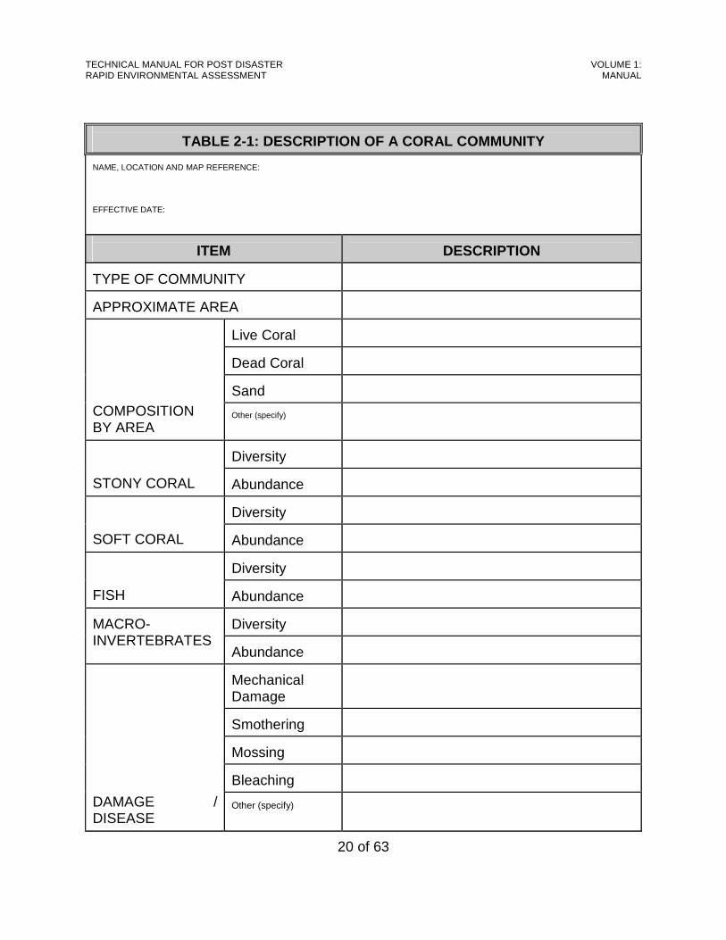
< evidence of damage or disease. Table 2-1 is an example of a simple summary of the description of a coral community. The following explanations apply: The Effective Date is the most recent date on which the description was updated. Type of Community may be barrier reef, fringing reef, patch reef, etc [see Reference Note 2.1.1). For Composition by Area , estimate the percentage area of the community covered by live coral,
dead coral, sandy bottom, etc. For Diversity and Abundance , use simple descriptors like normal, sub-normal or impoverished.
Definitions of A normal, sub-normal and impoverished should be gauged relative to other coral communities on the island.
For Damage / Disease , estimate the percentage of the community affected by each type
[See Reference Note 2.1.4].
2.3.3 Seagrass Beds As with coral communities, methods used to describe seagrass beds range from simple reconnaissance and observation to more structured methods [see Guidelines 2.1.2]. The description should contain information on:
< nature of the community;
< abundance and diversity of fish and macro-invertebrates; and
< evidence of damage or disease. A simple summary table (Form 2.2) for the description of a sea grass bed is found in Volume 2, to which the following explanations apply: The Effective Date is the most recent date on which the description was updated. For Composition by Area , estimate the percentage area of the bed covered by live seagrass,
dead seagrass, sandy bottom, rocks or rocky ledges, etc. For Diversity and Abundance , use simple descriptors like normal, sub-normal or impoverished.
Definitions of A normal , sub-normal and impoverished should be gauged relative to other seagrass beds on the island.
For Damage / Disease , estimate the percentage of the seagrass bed affected by each type

TECHNICAL MANUAL FOR POST DISASTER RAPID ENVIRONMENTAL ASSESSMENT
VOLUME 1: MANUAL
19 of 63
[See Reference Note 2.2.4].
TECHNICAL MANUAL FOR POST DISASTER RAPID ENVIRONMENTAL ASSESSMENT
VOLUME 1: MANUAL
20 of 63
TABLE 2-1: DESCRIPTION OF A CORAL COMMUNITY NAME, LOCATION AND MAP REFERENCE: EFFECTIVE DATE:
ITEM
DESCRIPTION TYPE OF COMMUNITY
APPROXIMATE AREA
Live Coral
Dead Coral
Sand
COMPOSITION BY AREA
Other (specify)
Diversity
STONY CORAL
Abundance
Diversity
SOFT CORAL
Abundance
Diversity
FISH
Abundance
Diversity
MACRO-INVERTEBRATES
Abundance
Mechanical Damage
Smothering
Mossing
Bleaching
DAMAGE / DISEASE
Other (specify)
TECHNICAL MANUAL FOR POST DISASTER RAPID ENVIRONMENTAL ASSESSMENT
VOLUME 1: MANUAL
21 of 63
2.3.4 Fishing Grounds The health of fishing grounds may be closely related to nearby coral reefs and seagrass beds but may also be independently described using the following criteria:
< Water quality (presence of solid waste, temperature, pH, total suspended solids, oil and grease, biochemical oxygen demand, total and faecal coliform),
< Fish species composition, and
< Fish landing data.
A simple summary table (Form 2.3) for the description of fishing grounds is found in Volume 2.
2.3.5 Sandy Beaches Two simple parameters may be used to describe the condition of sandy beaches: sand width to the high water mark, and consistency of the sand. The methods used to quantify these parameters vary in sophistication. The width of a beach may be simply paced off, or a beach profile could be measured using survey equipment. Similarly, the consistency of the sand may be described based on simple observation (fine sand, coarse sand with cobbles, etc) [see Guidelines 2.1.3], or samples of the sand may be sieved in a laboratory. A simple summary table (Form 2.4) for the description of a sandy beach is found in Volume 2.
2.3.6 Salt Ponds Salt ponds depend on a high salinity to maintain the halophytic organisms which inhabit the area. The health of the system is dependent on high salinity. Criteria which will help in describing ecosystem health are [see Reference Note 2.3]:
< Salinity,
< Physical status of the berm,
< Community composition An assessment of the salinity of the salt pond and the composition of the community will reveal the health of the system. As salinity becomes lower, halophytic organisms will die and will be replaced by less salt tolerant species. The physical condition of the berm will also give an indication of the health since any breaching of the berm is likely to lead to a lowering of salinity inside the pond. A simple summary table (Form 2.5) for the description of a salt pond is found in Volume 2.

TECHNICAL MANUAL FOR POST DISASTER RAPID ENVIRONMENTAL ASSESSMENT
VOLUME 1: MANUAL
22 of 63
2.3.7 Forests In the OECS, the health of forests can be described on the basis of:
< nature and structure of the forest [see Guidelines 2.1.4];
< abundance and diversity of avifauna and other fauna;
< human intrusion; and
< evidence of damage or disease. A simple summary table (Form 2.6) for the description of a forest is found in Volume 2, to which the following explanations apply: The Effective Date is the most recent date on which the description was updated. Type of Forest should be listed [see Reference Note 2.4.1], and special ecosystems or
rare/endangered species in the forest should be noted. For Diversity and Abundance , use simple descriptors like normal, sub-normal or impoverished.
Definitions of A normal, sub-normal and impoverished should be gauged relative to other forests of the same type on the island or elsewhere in the OECS.
Hunting and Logging include both legal and illegal activities. Reaping refers to the collection of forest products such as seeds, fruit, etc. For Damage / Disease , estimate the percentage of the forest affected by each type
[see Reference Notes 2.4.2 and 2.4.3].
2.3.8 Wetlands In the OECS, the health of wetlands [see Guidelines 2.1.5] can be described on the basis of:
< nature and structure of the wetland;
< abundance and diversity of avifauna, fish and macro-invertebrates;
< water quality; and
< evidence of damage or disease.

TECHNICAL MANUAL FOR POST DISASTER RAPID ENVIRONMENTAL ASSESSMENT
VOLUME 1: MANUAL
23 of 63
A simple summary table (Form 2.7) for the description of a wetland is found in Volume 2, to which the following explanations apply: The Effective Date is the most recent date on which the description was updated. Type of Wetland should be listed [see Reference Note 2.5], and special ecosystems or
rare/endangered species in the wetland should be noted. In the OECS, the majority of wetlands are mangroves, but other types may also be present.
For Diversity and Abundance , use simple descriptors like normal, sub-normal or impoverished.
Definitions of A normal, sub-normal and impoverished should be gauged relative to other wetlands of the same type on the island or elsewhere in the OECS.
For Diminished Water Quality , describe the prevalence of the problem. Reaping refers to the collection of products such as seeds, fruit, bark, etc. For Damage / Disease , estimate the percentage of the wetland affected by each type
[see Reference Notes 2.5.2 and 2.5.5].
2.3.9 Rivers, Streams and Ponds In order to assess the health of a surface water system there are two key factors which should be ascertained:
< Water Quality, and
< Biodiversity. Water Quality can be assessed based on sampling and testing (for temperature, pH, salinity, biochemical oxygen demand, total suspended solids, total and faecal coliform); or more simply based on gross indicators of pollution such as debris/garbage, odour and oil sheen. Biodiversity assessments can take the form of ichthyofaunal (fish) surveys while invertebrate surveys should focus on macroinvertebrates since these are usually more well known and are easier to spot and identify. A simple summary table (Form 2.8) for the description of rivers, streams and ponds is found in Volume 2.
TECHNICAL MANUAL FOR POST DISASTER RAPID ENVIRONMENTAL ASSESSMENT
VOLUME 1: MANUAL
24 of 63
2.3.10 Ground Water To assess the health of a groundwater reserve it is necessary to look at:
< Water Quality, and
< Sustainable Productivity. Because of the nature of ground water reserves, both of these parameters must be obtained by sampling and/or testing. This information must generally be accessed from the water utility, the water resources agency or the geological survey. A simple summary table (Form 2.9) for the description of ground water is found in Volume 2.
2.3.11 Historical and Archaeological Sites With respect to archaeological or historical sites, integrity (rather than Ahealth@) should be described based on criteria such as:
< Degree of Disturbance,
< Preservation of Artefacts, and
< Protection and Preservation of the Site.
A simple summary table (Form 2.10) for the description of historical and archaeological sites is found in Volume 2.
2.4. Financial Valuing of Assets Descriptions of the significant environmental assets cannot be complete without consideration of their economic value. Establishing the economic value of an asset prior to an adverse event will assist in the rapid assignment of a dollar value to the damage brought about by the event. The absence of this valuation will hinder the REA process making it impossible to be included in the initial damage assessment report.

TECHNICAL MANUAL FOR POST DISASTER RAPID ENVIRONMENTAL ASSESSMENT
VOLUME 1: MANUAL
25 of 63
There is no universal method which can be used for valuing all environmental assets and attempts have been made to value environmental assets on a financial basis using several methods. Seven such methods are introduced below:
< Insured Value, < Replacement Cost, < Earning Potential, < Level of Investment, < Willingness to Pay (Direct), < Willingness to Pay (Indirect), and < Unit Rates.
It must be noted, though, that each has drawbacks, which are also indicated.
2.4.1 Insurances Some environmental assets are insured against damage, particularly historical and archaeological sites. The insured value is determined by the operator of the site, and this may be taken as the value of the asset. The obvious drawback of this method is that many assets in the natural environment are not insured.
2.4.2 Replacement Cost This approach is based on the philosophy that the value of an environmental asset is the cost of replacing it. If, for example, a mangrove forest is filled in for the extension of an airport runway, then the value of that asset is the cost of creating an equal area of mangrove forest at another location. In applying this method, the following principles should be applied:
i All costs involved in the replacement should be included. This would include purchase value of land, cost of recreating the asset, and cost of care for a reasonable period until the asset is self-sustaining.
ii The real estate value of the land must be included, even where there is no
actual payment for the land. For example, a government may release state land at no cost to one of its agencies to replace an environmental asset, but this does not mean that the value of that land is zero.
iii Costing should be based on active rather than passive processes. For
example, costing of forest replacement should be based on the cost of growing seedlings, planting them and tending them until they are established. It is not
TECHNICAL MANUAL FOR POST DISASTER RAPID ENVIRONMENTAL ASSESSMENT
VOLUME 1: MANUAL
26 of 63
sufficient to provide the land and let nature take its course@. While this method has gained some degree of acceptance in the West Indies and internationally, it does have some drawbacks:
i It is not always possible to replace particular assets in a sustainable manner. For example, certain efforts to plant new areas of mangrove have been spectacularly unsuccessful.
ii In other situations, our incomplete understanding of ecosystem dynamics
makes it difficult (if not impossible) to successfully replace the asset. Certain forest types, for example, have proved impossible to replicate.
iii Replacement cost is relatively insensitive to the pre-existing quality of the
asset being replaced and the final quality of the replacement. It does not, for example, make any adjustment for the fact that the original asset may have been in very poor environmental health prior to the adverse event.
iv Finally, this method does not address the time value of replacement; that is,
the loss of productivity during the period between the removal of the original asset and the creation of a fully functional replacement.
2.4.3 Loss of Earnings A second approach is to evaluate the loss of potential earnings associated with the damage to the asset. For example, if a coral reef is damaged there would be losses to fishermen, dive shop operators, etc. The underlying philosophy here is that the value of an environmental asset is represented by the earnings derived from that asset. In applying this method, the following principles are important:
i The evaluation of earnings must include formal as well as informal earnings. For example, some environmental assets provide nutrition or building material to rural communities even though there is no transfer of cash.
ii The evaluation of earnings must also include direct as well as indirect
earnings. In the case of damage to a coral reef, fishermen and dive shop operators will suffer direct losses. Indirect losses would be suffered by other parts of the tourism industry (hotels, taxis, etc).
iii Because earnings will accumulate over time, it is necessary to determine the
time frame over which the analysis will be done. For example, if the asset will recover naturally over time, then the earnings will be computed only for the time that the asset is non-functional (or impaired). However, if an asset is totally destroyed, then earnings must be computed over the long-term.

TECHNICAL MANUAL FOR POST DISASTER RAPID ENVIRONMENTAL ASSESSMENT
VOLUME 1: MANUAL
27 of 63
Weaknesses of this method include:
i The method does not address benefits of the asset which do not include payments. For example, barrier reefs and mangroves help stabilize shorelines, but there is no cash payment for this.
ii The method assumes that environmental assets have no intrinsic value. It
only considers the value of the assets to society.
2.4.4 Loss of Investment This is a variation on the previous method, where the key indicator is the amount of money invested in an asset rather than the potential earnings from this asset. In this case, the value of a park is considered to be the total investment in developing the park. In using this method, the following principles must be applied:
i Formal as well as informal investments must be considered. For example, if there has been community action in preserving or developing an asset, the value of this action must be included (even if the community action was done on a voluntary basis).
ii The evaluation of investment must also include direct as well as indirect
investments. Thus, the valuation of a park would include the investment in guest houses catering to users of the park.
iii Principle ii, above, may be taken further to include loss of any investment
which is compromised by damage to the environmental asset. In such a case, the loss of investment would include beach-front structures which may be damaged due to increased erosion consequent on loss of a barrier reef.
Weaknesses of this method include:
i It is often difficult to realistically quantify informal investment.
ii The method assumes that environmental assets have no intrinsic value. It only considers the value of investment by society.
iii Notwithstanding Item ii, above, the method does not address cultural
sensitivities. For example, an asset which is used in cultural or religious ceremonies will have a value over and above the investment value.

TECHNICAL MANUAL FOR POST DISASTER RAPID ENVIRONMENTAL ASSESSMENT
VOLUME 1: MANUAL
28 of 63
2.4.5 Willingness to Pay (Direct) The concept of willingness to pay has been applied most commonly to the setting of entrance fees for particular environmental assets. However, it can be applied to evaluating environmental damage. The basic principle is to ask a representative section of the community what value they place on a particular asset. Specifically, they would be asked what they would be prepared to pay for the asset, or what they would consider a fair value for the sale of the asset to others. In applying this method, the following principles should be applied:
i The question of willingness to pay should be posed to a panel which is representative of society as a whole, and not biased to any particular segment of society.
ii Members of the panel should be selected so as to avoid any conflict of
interest on the part of any member. For example, if the purpose of the exercise is to levy a fine on a polluter, then no panel member should have an interest in the polluter.
iii It is likely that different panel members will indicate radically different values
for the same asset. In such a case, simply averaging the answers is not suitable. Instead, a system such as the Delphi Technique should be used to resolve the differences.
One major limitation of this method is the difference between stated willingness to pay and actual willingness to pay. There have been situations where the public was polled on their willingness to pay a particular level of entrance fee for an environmental asset, and the actual fee was established on that basis. When the asset was opened to the public, there was low attendance and complaints that the fees were too high.
2.4.6 Willingness to Pay (Indirect) In order to avoid the difference between stated willingness to pay and actual willingness to pay, it is sometimes possible to identify situations where there is an actual disparity in cost between the presence or the absence of an asset. For example, a forested area may serve as a buffer between a housing area and an industrial site, providing a reduction in noise levels. In such a circumstance, the difference in real estate values between those residential areas which enjoy the benefit of the buffer and those which do not would represent the value of the buffer.

TECHNICAL MANUAL FOR POST DISASTER RAPID ENVIRONMENTAL ASSESSMENT
VOLUME 1: MANUAL
29 of 63
There are two principal limitations to the use of this method:
i It is not always possible to find suitable situations on which to base the analysis.
ii As in the example above, the analysis may only address one aspect of the asset (noise barrier). Other aspects (such as ecological productivity) may not be included.
2.4.7 Unit Rates The application of unit rates to environmental assets is a variation of the foregoing methods, where several assets of a similar type are put to similar uses. Internationally, this method has been used quite frequently for valuing forests. Consider the case where several tracts of natural forest of the same association support a logging industry. Instead of valuing each tract separately, it is possible to derive an average value for a hectare of forest (based, say, on the earning potential). The value of each tract of forest can then be computed on the basis of area. Clearly, however, different forest associations would have different unit rates when the values of different timber species are significantly different, or if the non-timber products which are harvested vary with tree species.
2.4.8 Choice of Method The appropriate method for assigning a financial value to any particular environmental asset will depend on the nature of the asset, the use to which it is put and the availability of background data. Table 2-2 broadly summarizes the applicability of different valuation methods.
TABLE 2-2: APPLICABILITY OF VALUATION METHODS
ENVIRONMENTAL ASSETS
Insu
ranc
e
Rep
lace
men
t C
ost
Ear
ning
P
oten
tial
Leve
l of
Inve
stm
ent
Will
ingn
ess
to
Pay
Coral Communities Τ Τ Τ Sea Grass Beds Τ Fishing Grounds Τ Τ Sandy Beaches/Turtle Nesting Beaches Τ Τ Τ Τ Salt Ponds Τ Τ Forests & Special Land Habitats Τ Τ Τ Τ Wetlands Τ Τ Τ Rivers, Ponds & Streams Τ Τ Ground Water Τ Τ

TECHNICAL MANUAL FOR POST DISASTER RAPID ENVIRONMENTAL ASSESSMENT
VOLUME 1: MANUAL
30 of 63
Historical & Archaeological Sites Τ Τ Τ Τ
2.5. Ranking of Assets While it is desirable to protect all of an island=s environmental assets, this may not be practical in times of an adverse event. Therefore, as part of the disaster preparedness effort, it may be prudent to rank environmental assets so that in a post-disaster scenario priority may be given to the more important assets. This section provides information which may be used in the ranking of assets.
2.5.1 Ranking Criteria Ranking of assets must be a country-specific exercise. However, in addition to the health of the ecosystem [see Section 2.3, above], three other general criteria may be used in ranking:
< Uses and Economic Value [see Guidelines 2.2],
< Uniqueness, and
< Pre-existing Threats [see Guidelines 2.3]. The following rationale may be used in ranking environmental assets: i Assets which serve a greater number of uses and produce economic value may be
assigned a higher importance rank than those which serve less uses and produce less economic value.
ii Unique assets are more important than those which are more common (and hence easier to
replace). iii Assets which are under threat prior to an adverse event are likely to require a greater
protection effort in the post-disaster scenario than those which were not under threat.
2.5.2 “Red Flags” The concept of “red flags” is borrowed from EIA (environmental impact assessment) practice, and the term is used in this manual to describe assets which are so important that any damage would be considered to be extreme in nature, requiring positive and meaningful remedial action. Examples of “red flag” environmental assets would include sites of great religious importance or habitats of rare/endangered species.
TECHNICAL MANUAL FOR POST DISASTER RAPID ENVIRONMENTAL ASSESSMENT
VOLUME 1: MANUAL
31 of 63
CHAPTER 3: HUMAN-INDUCED HAZARDS
≡
Identification of locations at which hazardous mate rials are used or stored is important both to protect the environment and to protect emer gency workers.
The second aspect of preparatory work in the context of Post-Disaster Rapid Environmental Assessment is the identification of human induced hazards. In disaster management, hazards are commonly divided into natural and human-induced (sometimes called technological). The division is by no means clear-cut, but hazardous materials are classified as man-induced hazards. After an adverse event, it is usually impractical to seek out information on the location and nature of such hazards. Instead, to the extent practical, these must be identified and mapped in advance. Assembling data on these hazards is not intended to replace the work of specialized agencies such as the Fire Department. Instead, this information will be needed in the immediate post-disaster period to check whether there has been release of hazardous substances to the environment, and also to ensure that disaster response activities do not themselves lead to the release of these substances. In this chapter, we will discuss a number of hazardous materials which are present in several of the OECS Territories:
< Bulk Fuel Storage, < Explosives, < Agrochemicals, < Other Hazardous Substances, < Asbestos, and < PCBs.
It is recommended that relevant information on each hazardous material and/ or hazardous materials installation should be summarized in a convenient format for rapid retrieval. A suggested format for the summary sheet is provided in Section 3.7. This information may be stored on a computer, but a back-up copy on paper is strongly recommended [see Guidelines 3.1]. In compiling this information and mapping facilities, any additional threat posed by natural hazards must be recognized and recorded. For example, a hazardous materials release can be precipitated by a flood if the facility is located in a flood plain. Therefore in completing the description, the location and threat posed from flooding should be recorded. Similarly, facilities at threat from storm surge, unstable slopes or seismic induced shaking

TECHNICAL MANUAL FOR POST DISASTER RAPID ENVIRONMENTAL ASSESSMENT
VOLUME 1: MANUAL
32 of 63
should be carefully recorded.
3.1. Bulk Fuel Storage Fuel is stored in tanks of varying sizes and materials, above as well as below ground. Fuels themselves may be liquid (gasoline, kerosene, diesel, etc) or gaseous (compressed natural gas). Solid fuels are not as common in the OECS countries, and are also less prone to dispersion if containment is breached. In the context of this Manual, the term bulk storage is applied to storage tanks commercial-scale (as opposed to home-scale) storage facilities. In the case of liquid fuels, this is generally tanks in excess of 1,000 L. For gaseous fuels, tanks in excess of half-tonne capacity would be considered bulk tanks. Bulk storage of fuel is associated with a wide range of commercial activities. The most obvious are tank farms which store the country=s fuel supply, and fuel sales facilities, such as gas stations, ports, marinas, etc. In addition, certain commercial facilities themselves use significant quantities of fuel, and therefore store bulk quantities on site. For example, restaurants and hotels which use compressed natural gas (CNG) usually use half-tonne or one-tonne tanks. The list or map of bulk fuel storage facilities should indicate:
< the type of fuel and quantity being stored, and whether liquid or gaseous;
< the type of tank (material, whether above or below ground, and condition if available); and
< whether there is secondary containment (spill containment systems).
3.2. Explosives In the OECS, in common with the rest of the West Indies, the use of explosives is generally associated with quarrying. The importation, storage and use of explosives are usually closely regulated by the Police Service, so the location of storage bunkers for explosives is generally known to the authorities. However, for security reasons, the location of such facilities is considered to be confidential. For this reason, it is not recommended that the location of bunkers be shown on publicly available maps. Instead, the maps should list the contact information for the persons who can be contacted to obtain this information at short notice in the immediate post-disaster period.
TECHNICAL MANUAL FOR POST DISASTER RAPID ENVIRONMENTAL ASSESSMENT
VOLUME 1: MANUAL
33 of 63
3.3. Agrochemicals Agrochemicals (pesticides as well as fertilizers) are used in the OECS countries by small farmers and large estates. They may be natural or synthetic in origin and may be used alone or in mixtures to stimulate or regulate growth of produce and to control pests. This results in increased yields, and quality of produce, reduced production costs and increased income. A 1985 survey indicated that some 86 pesticide-active ingredients are marketed in the Eastern Caribbean. These include fungicides, herbicides, insecticides and infanticides; all of which are toxic to some degree. Over the years, the persistence of pesticides in the environment has been recognized as a significant problem, and newer pesticides are designed to degrade naturally in the soil. The most commonly used fertilizers are the NPK types containing nitrogen, phosphorus and potassium. Fertilizers are generally non-toxic, but can create environmental problems of eutrophication if released into water bodies. Eutrophication is the extreme growth of algae due to the presence of high concentrations of nutrient. As the amount of algae in the water increases, the available oxygen decreases. This can lead to die-off, decay and a further cycle of eutrophication. Listing or mapping all storage sites for agrochemicals is simply impractical. As with fuel, therefore, it is necessary to focus on the larger storage facilities. These include farm supply stores and central storage facilities for plantations. The list or map of agrochemical storage facilities should indicate:
< the type and quantities of agrochemicals being stored, and whether solid or liquid;
< the type of containers in which they are stored; and
< whether there is secondary containment (spill containment systems). In addition to the type, location and storage of these chemicals, useful information on their properties is readily available from the Material Safety Data Sheets [see Reference Note 3.1] which form a standard part of the delivery paperwork.
TECHNICAL MANUAL FOR POST DISASTER RAPID ENVIRONMENTAL ASSESSMENT
VOLUME 1: MANUAL
34 of 63
3.4. Other Hazardous Substances While the OECS countries are not highly industrialized, some industrial chemicals are used. In addition, infectious substances may be generated from health care facilities, laboratories and sewage treatment plants. The focus here should be on substances which may be classified as:
< Toxic, < Corrosive, < Flammable, < Explosive, or < Infectious.
As with agrochemicals, it would be impractical to list or map all such substances in the area of interest. Instead, the listing should focus on locations where significant volumes of these substances are stored. The list or map of storage facilities for hazardous substances should indicate:
< the type and quantities of substances being stored, and whether solid or liquid;
< the type of containers in which they are stored; and
< whether there is secondary containment (spill containment systems). Useful information on hazardous chemicals is readily available from the Material Safety Data Sheets [see Reference Note 3.1]. It is again recommended that relevant information from these sheets should be summarized in a convenient format for rapid retrieval. Information may be stored in a binder in the format shown in Table 3-1.
3.5. Asbestos Asbestos is being phased out of use world-wide, but it may be encountered in older buildings or equipment. Asbestos is an effective fire-retardant material which has been used as thermal insulation and roof and wall sheeting in the past. Asbestos is the generic name for six naturally occurring minerals that have been used in commercial products for their strength, flexibility, low electrical conductivity, and resistance to heat and chemicals. It is composed of silicon, oxygen, hydrogen, and various metals. Asbestos can be divided into two basic groups, serpentine and amphibole, which differ in their physical characteristics. Serpentine asbestos develops in a layered or tiered form,
TECHNICAL MANUAL FOR POST DISASTER RAPID ENVIRONMENTAL ASSESSMENT
VOLUME 1: MANUAL
35 of 63
whereas amphibole asbestos has a chain-like structure. The material is a mineral which consists of fibre bundles which easily separate into long, thin fibres. Positive identification of a specific fibre type requires microscopic analysis and examination. There are six types of asbestos:
< Chrysotile [White Asbestos), < Amosite [Brown Asbestos), < Crocidolite [Blue Asbestos), < Tremolite, < Anthophyllite, and < Actinolite.
All asbestos fibres are hazardous to human health. Asbestos exposure can cause serious diseases, including cancer. When inhaled, asbestos fibres enter the lungs where some of the fibres will be deposited in the air passages and on the cells making up the lungs. Some fibres remain trapped in the lungs, causing severe respiratory damage. Fibres that clear the lungs are carried away in a layer of mucus to the throat, where they are swallowed into the stomach. They may become stuck in the membranes lining the stomach or intestines, or be distributed throughout the body via the blood. Wherever the fibres are, they have the potential to promote genetic errors in cell division that can lead to cancer. In the context of this exercise, it is sufficient to list or map buildings with asbestos insulation or sheeting.
3.6. PCBs Polychlorinated Biphenyls [PCBs) like asbestos is also being phased out of use world-wide, but it may be encountered in older equipment. PCBs were used in electrical transformers and other equipment as a spark arrester. While they have excellent properties for this application, PCBs have also been found to be carcinogenic. The manufacture of PCBs was discontinued in 1976, and equipment manufactured after that year is unlikely to contain PCBs. Information should be available from the local electrical utility on the age of their transformers, and whether they are certified PCB-free. In addition, there are areas where old transformers are held for long term storage. The effort should also be made to ascertain whether these old pieces of equipment are PCB-free. Polychlorinated biphenyls are mixtures of up to 209 individual chlorinated compounds [known as congeners). They are either oily liquids or solids that are colourless to light yellow. Some PCBs can exist as a vapour in air. PCBs have no known smell or taste. The US EPA has determined that PCBs are toxic and persistent. PCBs can enter the body through the lungs, gastrointestinal tract, and skin, can circulate throughout the body, and
TECHNICAL MANUAL FOR POST DISASTER RAPID ENVIRONMENTAL ASSESSMENT
VOLUME 1: MANUAL
36 of 63
can be stored in the fatty tissue. Available animal studies indicate an oncogenic potential. The US EPA has also found that PCBs may cause reproductive effects and developmental toxicity in humans. Chloracne may also occur in humans exposed to PCBs. Certain PCB congeners are among the most stable chemicals known, which decompose very slowly once they are released in the environment. They are absorbed and stored in the fatty tissue of higher organisms as they bioaccumulate up the food chain through invertebrates, fish, and mammals. This ultimately results in human exposure through consumption of PCB-containing food sources. PCBs also have reproductive and other toxic effects in aquatic organisms, birds, and mammals.
3.7. Summary Sheets
3.7.1 Preparation Summary sheets for each of the hazardous materials facilities identified should be prepared as part of disaster preparedness. A possible format for these summary sheets [see Guidelines 3.2] is given in Table 3-1. These summary sheets should be kept in a binder and organized by location. In the event of an adverse event, those summary sheets pertaining to risk factors in the area of the adverse event can be easily obtained.
3.7.2 Updating Once the summary sheets have been prepared the process of updating and maintaining the database is an on-going one. New risk factors may be added, some may be no longer present in an area, or quantities may change.
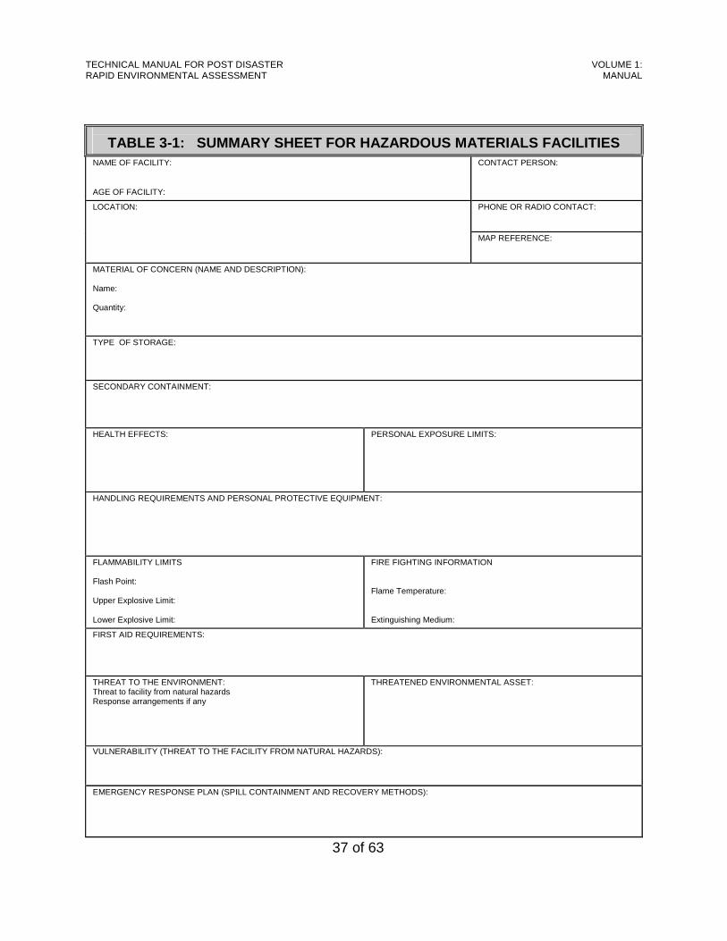
TECHNICAL MANUAL FOR POST DISASTER RAPID ENVIRONMENTAL ASSESSMENT
VOLUME 1: MANUAL
37 of 63
TABLE 3-1: SUMMARY SHEET FOR HAZARDOUS MATERIALS FACILITIES NAME OF FACILITY: AGE OF FACILITY:
CONTACT PERSON:
PHONE OR RADIO CONTACT:
LOCATION:
MAP REFERENCE:
MATERIAL OF CONCERN (NAME AND DESCRIPTION): Name: Quantity:
TYPE OF STORAGE: SECONDARY CONTAINMENT: HEALTH EFFECTS:
PERSONAL EXPOSURE LIMITS:
HANDLING REQUIREMENTS AND PERSONAL PROTECTIVE EQUIPMENT: FLAMMABILITY LIMITS Flash Point: Upper Explosive Limit: Lower Explosive Limit:
FIRE FIGHTING INFORMATION Flame Temperature: Extinguishing Medium:
FIRST AID REQUIREMENTS: THREAT TO THE ENVIRONMENT: Threat to facility from natural hazards Response arrangements if any
THREATENED ENVIRONMENTAL ASSET:
VULNERABILITY (THREAT TO THE FACILITY FROM NATURAL HAZARDS):
EMERGENCY RESPONSE PLAN (SPILL CONTAINMENT AND RECOVERY METHODS):

TECHNICAL MANUAL FOR POST DISASTER RAPID ENVIRONMENTAL ASSESSMENT
VOLUME 1: MANUAL
38 of 63
CHAPTER 4:
OPERATIONAL PROCEDURES Implementing the items in Chapters 2 and 3 will prepare environmental practitioners to fulfil their role in the response and recovery stages [see Guidelines 4]. This chapter and the next two describe the activities in which environmental practitioners will be involved after an adverse event [see Figures 1 and 2]:
i Operational Procedures, including safety concerns, ii Assessment of the damage to environmental assets in the affected area,
and iii Identification of environmental protection measures to be observed while
undertaking particular response/recovery.
4.1. Response Procedures Emergency events are managed from a command and control centre called an Emergency Operations Centre (EOC). EOCs can be activated for any level of response: community, regional or national. For events requiring coordination at the national level, the National Emergency Operations Centre (NEOC) is activated. The major functions of the EOC/NEOC are:
• Issuing of Warnings, • Co-ordination of all Response and Recovery Efforts, • Tracking and Provision of Resources, • Information Management, • Preparation of Reports (eg. Situation Updates, Damage Reports), • Provision of Communications, and • Issuing Needs Lists.
This section describes procedures to be followed by the REA Team during response. In the case of slow-onset events (such as hurricanes), warnings can be issued. However, for rapid-onset events (hazardous material spills or leaks), there is generally not sufficient time for warnings to be issued. As such, in the case of rapid-onset events, the response goes immediately to the activation of the EOC/NEOC (depending on the nature of the event).

TECHNICAL MANUAL FOR POST DISASTER RAPID ENVIRONMENTAL ASSESSMENT
VOLUME 1: MANUAL
39 of 63
4.1.1 Warning Phase During this phase, the REA Team will:
• Provide maps, data and vulnerability and risk assessments.
• Advise on preparedness or precautionary measures to be taken.
4.1.2 Activation During the activation phase, the members of the REA Team will report to the EOC/NEOC, along with other members of the respective sub-committees. It is important that existing call-out procedures be amended to include the REA Team.
4.1.3 Response During the Response Phase, the REA Team will:
• Forecast Impacts based on available data,
• Participate in Initial Situation Overview and Initial Damage Assessment,
• Guide Damage Assessment Checks based on forecasts,
• Advise on Hazardous Materials response,
• Map Impacts,
• Advise on Hazardous Materials Containment and Clean-up (as required), and
• Advise on and Oversee Environmental Protection Measures.
4.1.4 Rehabilitation During Rehabilitation, the REA Team will:
• Continue Recording of Impacts, • Continue Advising on Environmental Protection Measures, • Monitor Rehabilitation Efforts and Ensure Compliance, and • Provide “Bridging” to the Rebuilding Phase.
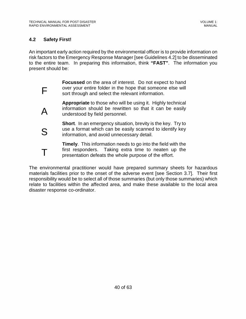
TECHNICAL MANUAL FOR POST DISASTER RAPID ENVIRONMENTAL ASSESSMENT
VOLUME 1: MANUAL
40 of 63
4.2 Safety First! An important early action required by the environmental officer is to provide information on risk factors to the Emergency Response Manager [see Guidelines 4.2] to be disseminated to the entire team. In preparing this information, think “FAST” . The information you present should be:
F
Focussed on the area of interest. Do not expect to hand over your entire folder in the hope that someone else will sort through and select the relevant information.
A
Appropriate to those who will be using it. Highly technical information should be rewritten so that it can be easily understood by field personnel.
S
Short . In an emergency situation, brevity is the key. Try to use a format which can be easily scanned to identify key information, and avoid unnecessary detail.
T
Timely . This information needs to go into the field with the first responders. Taking extra time to neaten up the presentation defeats the whole purpose of the effort.
The environmental practitioner would have prepared summary sheets for hazardous materials facilities prior to the onset of the adverse event [see Section 3.7]. Their first responsibility would be to select all of those summaries (but only those summaries) which relate to facilities within the affected area, and make these available to the local area disaster response co-ordinator.
TECHNICAL MANUAL FOR POST DISASTER RAPID ENVIRONMENTAL ASSESSMENT
VOLUME 1: MANUAL
41 of 63
CHAPTER 5: ASSESSMENT OF DAMAGE
Following an adverse event (associated either with natural or human phenomena) immediate response is needed as well as an assessment is required to rapidly determine the degree of damage suffered by environmental assets, and also to determine the appropriate response to the damage. This chapter describes the role of the REA Team in during the initial situation review and a tool for rapidly assessing the damage to the natural environment by adverse events due to natural and human phenomena. It begins by describing the format for presenting the initial report to the NEOC then goes on to describe the Rapid Assessment Tool, including the valuation of damage. The final section provides more details relative to each of the environmental assets listed in Section 2.1.
5.1. Initial Report An adverse event can cause environmental impact immediately or pose a threat. For example, an earthquake can result in physical damage to a hazardous materials installation, resulting in a spill or leak. In a case such as this, immediate response is needed, and the REA Team must be directly involved in the response by providing technical support to emergency response personnel. Potential threats can be forecast based on knowledge of the area impacted and the existing database, or will be revealed during the initial situation overview [see Section 1.2.2, above]. For potential threats, the REA Team will advise on how impact can be prevented or reduced. In all cases a quick assessment and report back to the NEOC is needed [see Section 4.1, above]. Once the actual or potential situation is stabilized, the REA tool can be applied. A suggested format for presenting the initial summary report to the NEOC is shown in Table 5-1.
5.2. Rapid Assessment Tool This section presents the rapid assessment tool, and then discusses the timing of its application and the scope of inspections which are necessary for the application of the method.
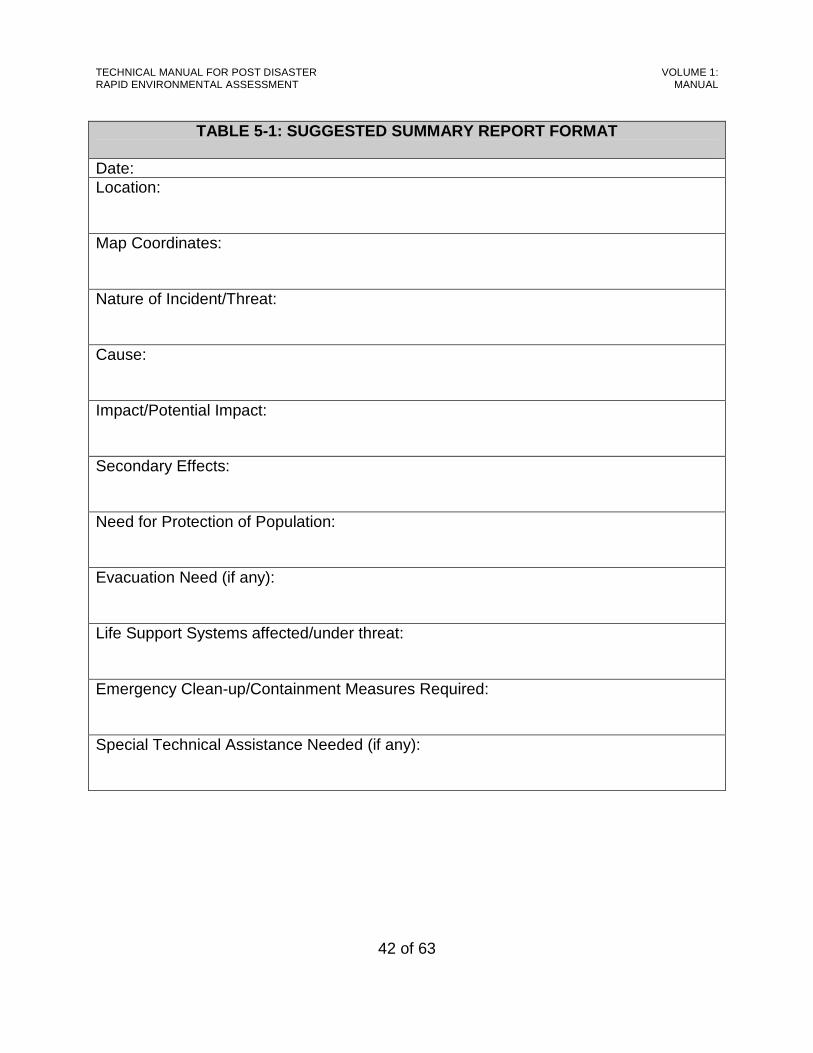
TECHNICAL MANUAL FOR POST DISASTER RAPID ENVIRONMENTAL ASSESSMENT
VOLUME 1: MANUAL
42 of 63
TABLE 5-1: SUGGESTED SUMMARY REPORT FORMAT
Date: Location: Map Coordinates: Nature of Incident/Threat: Cause: Impact/Potential Impact: Secondary Effects: Need for Protection of Population: Evacuation Need (if any): Life Support Systems affected/under threat: Emergency Clean-up/Containment Measures Required: Special Technical Assistance Needed (if any):
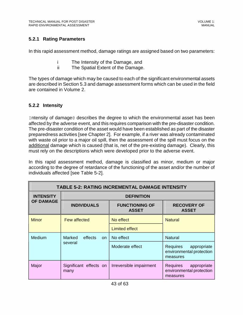
TECHNICAL MANUAL FOR POST DISASTER RAPID ENVIRONMENTAL ASSESSMENT
VOLUME 1: MANUAL
43 of 63
5.2.1 Rating Parameters In this rapid assessment method, damage ratings are assigned based on two parameters:
i The Intensity of the Damage, and ii The Spatial Extent of the Damage.
The types of damage which may be caused to each of the significant environmental assets are described in Section 5.3 and damage assessment forms which can be used in the field are contained in Volume 2.
5.2.2 Intensity Intensity of damage@ describes the degree to which the environmental asset has been affected by the adverse event, and this requires comparison with the pre-disaster condition. The pre-disaster condition of the asset would have been established as part of the disaster preparedness activities [see Chapter 2]. For example, if a river was already contaminated with waste oil prior to a major oil spill, then the assessment of the spill must focus on the additional damage which is caused (that is, net of the pre-existing damage). Clearly, this must rely on the descriptions which were developed prior to the adverse event. In this rapid assessment method, damage is classified as minor, medium or major according to the degree of retardance of the functioning of the asset and/or the number of individuals affected [see Table 5-2].
TABLE 5-2: RATING INCREMENTAL DAMAGE INTENSITY
DEFINITION INTENSITY
OF DAMAGE INDIVIDUALS
FUNCTIONING OF
ASSET
RECOVERY OF
ASSET No effect
Minor
Few affected
Limited effect
Natural
No effect
Natural
Medium
Marked effects on several
Moderate effect Requires appropriate environmental protection measures
Major
Significant effects on many
Irreversible impairment
Requires appropriate environmental protection measures
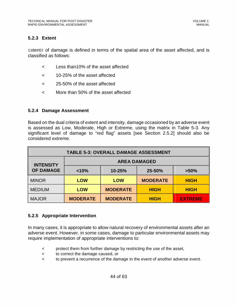
TECHNICAL MANUAL FOR POST DISASTER RAPID ENVIRONMENTAL ASSESSMENT
VOLUME 1: MANUAL
44 of 63
5.2.3 Extent Extent@ of damage is defined in terms of the spatial area of the asset affected, and is classified as follows:
< Less than10% of the asset affected
< 10-25% of the asset affected
< 25-50% of the asset affected
< More than 50% of the asset affected
5.2.4 Damage Assessment Based on the dual criteria of extent and intensity, damage occasioned by an adverse event is assessed as Low, Moderate, High or Extreme, using the matrix in Table 5-3. Any significant level of damage to “red flag” assets [see Section 2.5.2] should also be considered extreme.
TABLE 5-3: OVERALL DAMAGE ASSESSMENT
AREA DAMAGED INTENSITY
OF DAMAGE
<10%
10-25%
25-50%
>50% MINOR
LOW
LOW
MODERATE
HIGH
MEDIUM
LOW
MODERATE
HIGH
HIGH
MAJOR
MODERATE
MODERATE
HIGH
EXTREME
5.2.5 Appropriate Intervention In many cases, it is appropriate to allow natural recovery of environmental assets after an adverse event. However, in some cases, damage to particular environmental assets may require implementation of appropriate interventions to:
< protect them from further damage by restricting the use of the asset, < to correct the damage caused, or < to prevent a recurrence of the damage in the event of another adverse event.
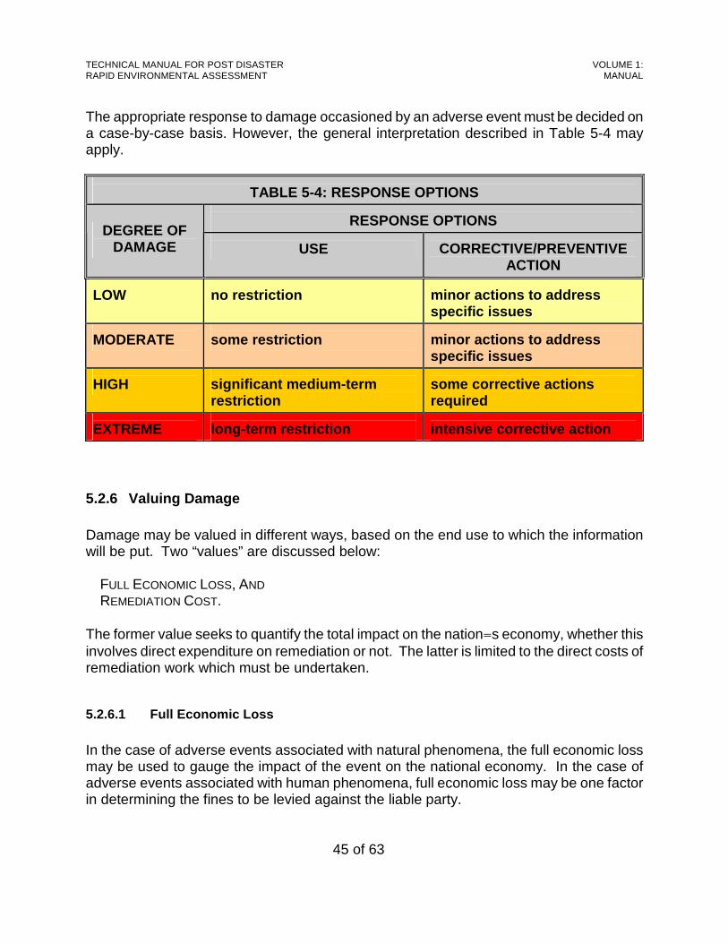
TECHNICAL MANUAL FOR POST DISASTER RAPID ENVIRONMENTAL ASSESSMENT
VOLUME 1: MANUAL
45 of 63
The appropriate response to damage occasioned by an adverse event must be decided on a case-by-case basis. However, the general interpretation described in Table 5-4 may apply.
TABLE 5-4: RESPONSE OPTIONS
RESPONSE OPTIONS DEGREE OF
DAMAGE
USE
CORRECTIVE/PREVENTIVE ACTION
LOW
no restriction
minor actions to address specific issues
MODERATE
some restriction
minor actions to address specific issues
HIGH
significant medium-term restriction
some corrective actions required
EXTREME
long-term restriction
intensive corrective action
5.2.6 Valuing Damage Damage may be valued in different ways, based on the end use to which the information will be put. Two “values” are discussed below:
FULL ECONOMIC LOSS, AND REMEDIATION COST.
The former value seeks to quantify the total impact on the nation=s economy, whether this involves direct expenditure on remediation or not. The latter is limited to the direct costs of remediation work which must be undertaken.
5.2.6.1 Full Economic Loss
In the case of adverse events associated with natural phenomena, the full economic loss may be used to gauge the impact of the event on the national economy. In the case of adverse events associated with human phenomena, full economic loss may be one factor in determining the fines to be levied against the liable party.
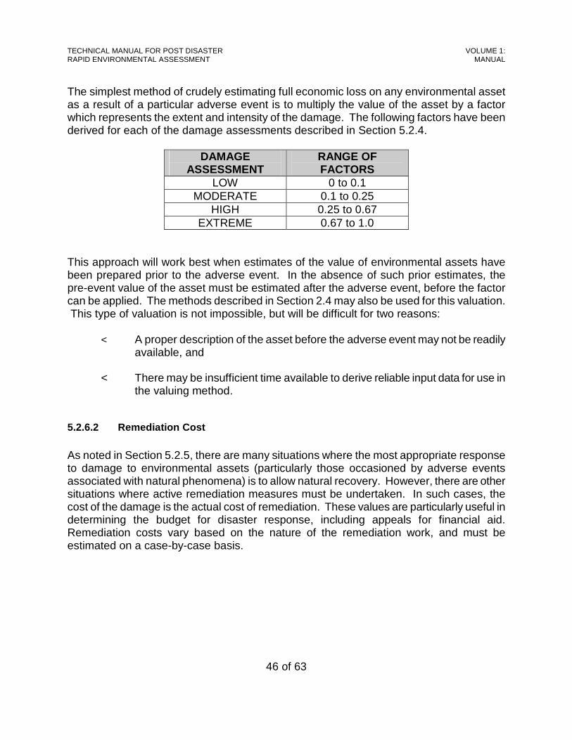
TECHNICAL MANUAL FOR POST DISASTER RAPID ENVIRONMENTAL ASSESSMENT
VOLUME 1: MANUAL
46 of 63
The simplest method of crudely estimating full economic loss on any environmental asset as a result of a particular adverse event is to multiply the value of the asset by a factor which represents the extent and intensity of the damage. The following factors have been derived for each of the damage assessments described in Section 5.2.4.
DAMAGE ASSESSMENT
RANGE OF FACTORS
LOW 0 to 0.1 MODERATE 0.1 to 0.25
HIGH 0.25 to 0.67 EXTREME 0.67 to 1.0
This approach will work best when estimates of the value of environmental assets have been prepared prior to the adverse event. In the absence of such prior estimates, the pre-event value of the asset must be estimated after the adverse event, before the factor can be applied. The methods described in Section 2.4 may also be used for this valuation. This type of valuation is not impossible, but will be difficult for two reasons:
< A proper description of the asset before the adverse event may not be readily available, and
< There may be insufficient time available to derive reliable input data for use in
the valuing method.
5.2.6.2 Remediation Cost
As noted in Section 5.2.5, there are many situations where the most appropriate response to damage to environmental assets (particularly those occasioned by adverse events associated with natural phenomena) is to allow natural recovery. However, there are other situations where active remediation measures must be undertaken. In such cases, the cost of the damage is the actual cost of remediation. These values are particularly useful in determining the budget for disaster response, including appeals for financial aid. Remediation costs vary based on the nature of the remediation work, and must be estimated on a case-by-case basis.

TECHNICAL MANUAL FOR POST DISASTER RAPID ENVIRONMENTAL ASSESSMENT
VOLUME 1: MANUAL
47 of 63
5.2.7 Timing This manual was developed with a view to having the assessment of environmental damage undertaken relatively early in the post-disaster period ideally, at the same time that the other members of the evaluation team are in the field undertaking the initial damage assessment (IDA) [see Section 1.2.2]. However, issues of safety and access may preclude that approach and the results of the assessment may coincide with the detailed sector assessment (DSA) [see Section 1.2.2]. In general, the following will apply:
i Damage to terrestrial and coastal assets (salt ponds, forests, wetlands, beaches, surface waters and historical and archaeological sites) can be assessed within 24 to 48 hours of the adverse event.
ii Damage to marine assets (coral reefs, sea grass beds and fishing grounds) cannot
be assessed until marine conditions have stabilized and it is safe to enter the sea. This often means that the assessment will not be undertaken until several days after the adverse event.
iii Damage to groundwater cannot be rapidly assessed because of its location.
However, the threats to groundwater which have been created by the occurrence of the adverse event can be identified soon following the adverse event, and measures implemented to minimize the damage [see Chapter 6].
5.2.8 Scope of Inspections In carrying out the damage assessment, those assets which are within areas affected by the adverse event should be selected for inspection. It would be relatively simple to identify such assets from the database which was compiled in the disaster preparedness phase [see Section 2.2]. If the area affected by the adverse event is large and it encompasses many assets, it may be impractical to inspect each one. In such cases, inspections should focus on typical and important assets [see Section 2.5].
5.3. Types of Damage This section summarizes the various types of damage [see Guidelines 5) which may be noted at each of the environmental assets listed in Section 2.1, in the immediate aftermath of an adverse event. A suggested format for summarizing and presenting the assessment of a coral community is included in this section, while similar formats for summarizing and presenting the assessment of other types of environmental assets are included among the Tables in Volume 2.

TECHNICAL MANUAL FOR POST DISASTER RAPID ENVIRONMENTAL ASSESSMENT
VOLUME 1: MANUAL
48 of 63
5.3.1 Coral Communities In the immediate aftermath of an adverse event, the following types of damage to coral communities may be observed [see Guidelines 5.2.1]:
< Mechanical Damage , which can result from storm surges or grounding of ships.
< Smothering , related to the releases of silt or ash laden waters associated with storms or volcanic activity.
< Impeding of Light , again due to releases of silt or ash laden water.
< Fish Kills , due to releases of toxic material (as evidenced by dead fish or
macroinvertibrates).
< Extraneous Matter , which may have been transported (such as garbage, etc) or scraped (such as anti-foulant paint from ships) onto the coral.
A suggested format for summarizing and presenting the assessment of damage to a coral community is included as Form 5-1 of Volume 2 and shown in Table 5-4.

TECHNICAL MANUAL FOR POST DISASTER RAPID ENVIRONMENTAL ASSESSMENT
VOLUME 1: MANUAL
49 of 63
TABLE 5-5: FORM FOR ASSESSMENT OF DAMAGE TO A CORAL REEF
IMPACT INTENSITY SPATIAL EXTENT
DAMAGE RATING
Mechanical Damage
Smothering
Impeding of Light
“Fish Kills”
Extraneous Matter
Effective Assessment
Value of Asset Prior to Event $
Damage Factor: (0 to 0.1 for a Low Effective Assessment, 0.1 to 0.25 for a Moderate Effective Assessment, 0.25 to 0.66 for a High Effective Assessment, and 0.66 to 1.0 for an Extreme Effective Assessment)
Full Economic Loss (asset value times damage factor) $
Appropriate Responses:
Restriction of Use: Corrective Action(s): Long-Term Measure(s): Other:
Remediation Cost $

TECHNICAL MANUAL FOR POST DISASTER RAPID ENVIRONMENTAL ASSESSMENT
VOLUME 1: MANUAL
50 of 63
5.3.2 Seagrass Beds In the immediate aftermath of an adverse event, the following types of damage to seagrass beds may be observed [see Guidelines 5.2.2]:
< Uprooting , which can result from storm surges or grounding of ships.
< Smothering , related to silt or ash laden water.
< Impeding of Light , due to releases of silt or ash laden water.
< Fish Kills , due to releases of toxic material (as evidenced by dead fish or macroinvertibrates).
< Extraneous Matter , which may have been transported onto the sea grass bed.
A suggested format for summarizing and presenting the assessment of damage to seagrass beds is contained in Form 5-2 in Volume 2.
5.3.3 Fishing Grounds In the immediate aftermath of an adverse event, the following types of damage to fishing grounds may be observed [see Guidelines 5.2.3]:
< Mechanical Damage , which can result from grounding of ships.
< Smothering , related to releases of silt or ash laden water.
< Impeding of Light , again due to releases of silt or ash laden water.
< Fish Kills , due to releases of toxic material (as evidenced by dead fish or macroinvertibrates).
< Extraneous Matter , which may have been transported into the fishing ground
(including trees and branches which may snag nets and lines). A suggested format for summarizing and presenting the assessment of damage to fishing grounds is contained in Form 5-3 in Volume 2.

TECHNICAL MANUAL FOR POST DISASTER RAPID ENVIRONMENTAL ASSESSMENT
VOLUME 1: MANUAL
51 of 63
5.3.4 Sandy Beaches In the immediate aftermath of an adverse event, the following types of damage to sandy beaches may be observed [see Guidelines 5.2.4]:
< Loss of Beach Width , due to surges or changed wave patterns.
< Sand Migration , and particularly the movement of sand from the beach further inland (may also result in loss of beach width, or changed composition).
< Scouring across the beach, due to flood runoff.
< Changed Composition , due either to washout of fine particles (leaving gravel,
cobbles and boulders) or blanketing of the beach with mud due to flood runoff or with volcanic discharges.
< Contamination (of sand or water) due to oil, sewage, industrial and agro-chemical
discharges.
< Littering of the beach with solid debris. A suggested format for summarizing and presenting the assessment of damage to sandy beaches is contained in Form 5-4 in Volume 2.
5.3.5 Salt Ponds In the immediate aftermath of an adverse event, the following types of damage to salt ponds may be observed [see Guidelines 5.2.5]:
< Breached Berm removing the separation of the pond from the sea. This generally leads to washing-out of the pond.
< Filling Up due to ingress of silt, volcanic ash, etc.
< Contamination due to oil, sewage, industrial and agro-chemical discharges.
< Littering of the pond with solid debris.
It should be noted that hydrogen sulphide may be released into the surrounding environment if the sediment of a salt pond is disturbed. A suggested format for summarizing and presenting the assessment of damage to salt ponds is contained in Form 5-5 in Volume 2.
TECHNICAL MANUAL FOR POST DISASTER RAPID ENVIRONMENTAL ASSESSMENT
VOLUME 1: MANUAL
52 of 63
5.3.6 Forests In the immediate aftermath of an adverse event, the following types of damage to forests may be observed [see Guidelines 5.2.6]:
< Defoliation , that is, the loss of leaves due to strong winds or airborne toxicants.
< Broken Limbs , again due to strong winds, heavy rains or physical impact.
< Tree Fall or Clearing , due to heavy rainfall, strong winds, or physical impact.
< Landslide / Mudslide Damage
< Fire Damage . A suggested format for summarizing and presenting the assessment of damage to forests is contained in Form 5-6 in Volume 2.
5.3.7 Wetlands In the immediate aftermath of an adverse event, the following types of damage to wetlands may be observed [see Guidelines 5.2.7]:
< Defoliation , that is, the loss of leaves due to strong winds or airborne toxicants.
< Broken Limbs , again due to strong winds, heavy rains or physical impact.
< Tree Fall or Clearing , due to heavy rainfall, strong winds, or physical impact.
< Impaired Drainage , which prevents efficient flushing of the wetland.
< Filling Up due to ingress of silt, volcanic ash, etc.
< Contamination due to oil, sewage, industrial and agro-chemical discharges.
< Littering of the wetland with solid debris. A suggested format for summarizing and presenting the assessment of damage to wetlands is contained in Form 5-7 in Volume 2.
TECHNICAL MANUAL FOR POST DISASTER RAPID ENVIRONMENTAL ASSESSMENT
VOLUME 1: MANUAL
53 of 63
5.3.8 Rivers, Ponds and Streams In the immediate aftermath of an adverse event, the following types of damage to rivers, ponds and streams may be observed [see Guidelines 5.2.8]:
< Fish Kills , usually associated with the inflow of toxicants.
< Impaired Drainage , which prevents efficient flow of water. This may be associated with the inflow of silt, volcanic ash, etc; or the presence of large obstructions such as fallen trees, etc.
< Altered Channels usually result as a result of impaired drainage.
< Contamination due to oil, sewage, industrial and agro-chemical discharges.
< Littering of the water body with solid debris.
A suggested format for summarizing and presenting the assessment of damage to surface waters is contained in Form 5-8 in Volume 2.
5.3.9 Ground Water Damage to ground water resources is normally associated with contamination, and (to a lesser extent) with impairment of recharge areas. It is impractical to rapidly assess such damage in the immediate aftermath of an adverse event. A suggested format for summarizing and presenting the assessment of potential damage to ground water is contained in Form 5-9 in Volume 2.
5.3.10 Historical and Archaeological Sites Damage to historical and archaeological sites will consist of physical damage to sites, structures, etc. which can usually be readily identified during site inspection.
< Structural Damage < Landslides < Burial
A suggested format for summarizing and presenting the assessment of damage to
TECHNICAL MANUAL FOR POST DISASTER RAPID ENVIRONMENTAL ASSESSMENT
VOLUME 1: MANUAL
54 of 63
historical and archaeological sites is contained in Form 5-10 in Volume 2.
5.3.11 Summary of Results It is useful to summarize the assessment of damage for presentation, and the matrix in Table 5-6 is an example of such a presentation. This is based on the damage sustained by a coral reef due to the grounding of a ship. In this example using the method described in Section 5.1, above, two levels of damage are recorded: low and moderate. In such cases, the higher assessment value is accepted. Thus, the report on this assessment would be that the reef has suffered a moderate degree of damage as a result of the grounding @. Let us assume that the value of this asset was estimated at $450,000 (based on earning potential) prior to the event. Applying a damage factor of 0.2 [see Section 5.1.6.1], the full economic loss would be estimated as $90,000. In this particular case, a number of remedial actions were deemed appropriate:
< Restrict access to the reef until the coral has been cleaned of extraneous matter, and for a period of six months thereafter.
< Clean adhering extraneous matter from the coral, collect this material, and store and
dispose of appropriately (depending on its nature).
< Verify that the presence of this coral reef is properly marked on navigation charts. The cost of removing the extraneous matter from the coral, storing and disposing of it was estimated at US$2,700.
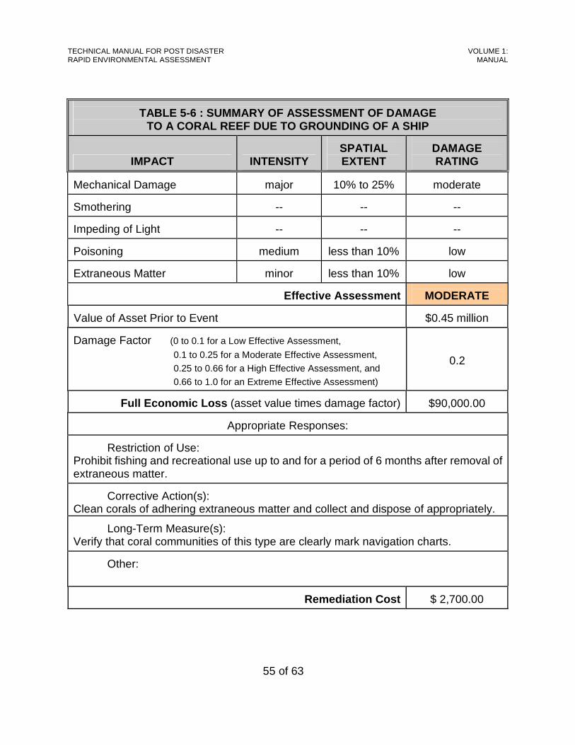
TECHNICAL MANUAL FOR POST DISASTER RAPID ENVIRONMENTAL ASSESSMENT
VOLUME 1: MANUAL
55 of 63
TABLE 5-6 : SUMMARY OF ASSESSMENT OF DAMAGE TO A CORAL REEF DUE TO GROUNDING OF A SHIP
IMPACT INTENSITY
SPATIAL EXTENT
DAMAGE RATING
Mechanical Damage
major
10% to 25%
moderate
Smothering
--
--
--
Impeding of Light
--
--
--
Poisoning
medium
less than 10%
low
Extraneous Matter
minor
less than 10%
low
Effective Assessment
MODERATE
Value of Asset Prior to Event
$0.45 million
Damage Factor (0 to 0.1 for a Low Effective Assessment,
0.1 to 0.25 for a Moderate Effective Assessment,
0.25 to 0.66 for a High Effective Assessment, and
0.66 to 1.0 for an Extreme Effective Assessment)
0.2
Full Economic Loss (asset value times damage factor)
$90,000.00
Appropriate Responses:
Restriction of Use:
Prohibit fishing and recreational use up to and for a period of 6 months after removal of extraneous matter.
Corrective Action(s): Clean corals of adhering extraneous matter and collect and dispose of appropriately.
Long-Term Measure(s): Verify that coral communities of this type are clearly mark navigation charts.
Other:
Remediation Cost
$ 2,700.00
TECHNICAL MANUAL FOR POST DISASTER RAPID ENVIRONMENTAL ASSESSMENT
VOLUME 1: MANUAL
56 of 63
CHAPTER 6: MEASURES TO MINIMIZE
ENVIRONMENTAL DAMAGE This chapter presents simple measures which can be implemented during the response and recovery stages to minimize the potential for damage to the natural environment by specific activities. Two approaches are presented, a basic checklist format and a somewhat simplified alternative format.
≡
The environmental checklists introduced in this cha pter list potential measures for environmental protection, but each measure must be evaluated in the context of the specific disaster response situation. Some measure s may be inappropriate in particular circumstances.
6.1. Basic Checklist Format
6.1.1 Layout For each selected action, the environmental protection measures are arranged in the form of a checklist as shown in Forms 6A-1 to 6A-16 of Volume 2, and illustrated in Table 6-1. The first group of columns list different components of the environment which would be protected by particular measures. The relationship between measures and environmental components are indicated by a check mark in the matrix. For convenience, the environmental protection measures are arranged in two groups: one consisting of general measures which may be applied during both the response and recovery stages, and the other consisting of measures which are more applicable to the recovery stage.
6.1.2 Example The use of this checklist is illustrated by the following example: Following an adverse event, it is necessary to build a temporary jetty on XYZ Beach. This
beach is a popular recreation spot, and there is a small wetland to the site of it. In the checklist, the Environmental Professional identifies the column “Sandy Beaches &
Turtle Nesting (shown in red in Table 6-1). Working down this column, there are three measures which are intended to protect a sandy beach (follow the red arrows to the appropriate check marks). The Environmental professional marks these measures with an “X” in the penultimate column.
TECHNICAL MANUAL FOR POST DISASTER RAPID ENVIRONMENTAL ASSESSMENT
VOLUME 1: MANUAL
57 of 63
Next, Environmental Professional identifies the column “wetlands” (shown in blue in Table 6-1). Working down this column, there is one measure which is intended to protect a wetland (follow the blue arrows to the appropriate check marks). The Environmental Professional marks this measure with an “X” in the penultimate column.
The checklist is now given to the personnel who are responsible for building the temporary
jetty, and they will implement the measures marked with an “X” in the penultimate column if they are practicable in the field.
Field personnel will indicate in the last column which measures were implemented. Where
particular measures were not implemented, they should so indicate by way of a note. For example, they may indicate that there has never been a jetty on this beach, so the first measure was not applicable.
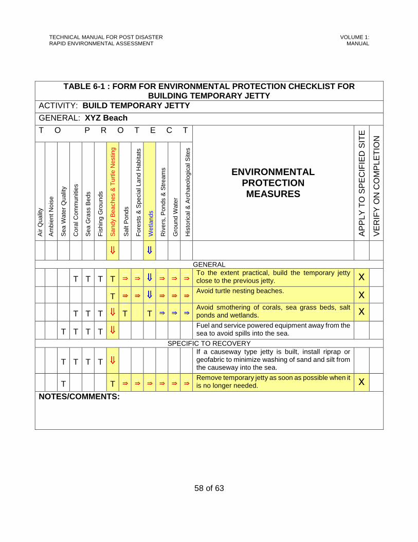
TECHNICAL MANUAL FOR POST DISASTER RAPID ENVIRONMENTAL ASSESSMENT
VOLUME 1: MANUAL
58 of 63
TABLE 6-1 : FORM FOR ENVIRONMENTAL PROTECTION CHECK LIST FOR BUILDING TEMPORARY JETTY
ACTIVITY: BUILD TEMPORARY JETTY
GENERAL: XYZ Beach
T O P R O T E C T
Air
Qua
lity
Am
bien
t Noi
se
Sea
Wat
er Q
ualit
y
Cor
al C
omm
uniti
es
Sea
Gra
ss B
eds
Fis
hing
Gro
unds
San
dy B
each
es &
Tur
tle N
estin
g
Sal
t Pon
ds
For
ests
& S
peci
al L
and
Hab
itats
Wet
land
s
Riv
ers,
Pon
ds &
Str
eam
s
Gro
und
Wat
er
His
toric
al &
Arc
haeo
logi
cal S
ites
ENVIRONMENTAL PROTECTION MEASURES
AP
PLY
TO
SP
EC
IFIE
D S
ITE
VE
RIF
Y O
N C
OM
PLE
TIO
N
⇓⇓⇓⇓ ⇓⇓⇓⇓
GENERAL
Τ
Τ
Τ
Τ ⇒⇒⇒⇒ ⇒⇒⇒⇒ ⇓⇓⇓⇓ ⇒⇒⇒⇒ ⇒⇒⇒⇒ ⇒⇒⇒⇒ To the extent practical, build the temporary jetty close to the previous jetty. x
Τ ⇒⇒⇒⇒ ⇒⇒⇒⇒ ⇓⇓⇓⇓ ⇒⇒⇒⇒ ⇒⇒⇒⇒ ⇒⇒⇒⇒ Avoid turtle nesting beaches. x
Τ
Τ
Τ ⇓⇓⇓⇓
Τ
Τ ⇒⇒⇒⇒ ⇒⇒⇒⇒ ⇒⇒⇒⇒ Avoid smothering of corals, sea grass beds, salt ponds and wetlands. x
Τ
Τ
Τ
Τ ⇓⇓⇓⇓ Fuel and service powered equipment away from the sea to avoid spills into the sea.
SPECIFIC TO RECOVERY
Τ
Τ
Τ
Τ ⇓⇓⇓⇓ If a causeway type jetty is built, install riprap or geofabric to minimize washing of sand and silt from the causeway into the sea.
Τ
Τ ⇒⇒⇒⇒ ⇒⇒⇒⇒ ⇒⇒⇒⇒ ⇒⇒⇒⇒ ⇒⇒⇒⇒ ⇒⇒⇒⇒ Remove temporary jetty as soon as possible when it is no longer needed. x
NOTES/COMMENTS:

TECHNICAL MANUAL FOR POST DISASTER RAPID ENVIRONMENTAL ASSESSMENT
VOLUME 1: MANUAL
59 of 63
6.1.3 Typical Response/Recovery Activities Checklists were developed for a range of typical response and recovery activities which were identified during meetings and interviews with emergency management agencies in the OECS and other Caribbean territories:
< Establish Temporary Staging Areas, < Build Temporary Jetties, < Build Emergency Helipad, < Re-open/Repair Roads, < Clear/Reopen Runways, < Restore Electricity/Communication, < Restore Water Supply, < Clear Drains and Rivers, < Temporary Stabilization of Landslips, < Temporary Stabilization of Shorelines, < Clean-up Buildings, < Demolition and Clearing of Damaged Structures, < Build Temporary Accommodation, < Vector Control, and < Containment and Collection of Chemical and Fuel Spills.
Notes on these activities are provided below, and the corresponding checklists are included in Volume 2, Part I, Forms 6A-1 to 6A-16.
6.1.3.1 Establish Temporary Staging Areas
One of the earliest activities in disaster response is the establishment of staging areas where personnel can assemble and material, fuel and equipment can be stored prior to deployment. It is desirable to pre-select these areas, but the final decision can only be made after the adverse event.
6.1.3.2 Build Temporary Jetties
On occasion, it is necessary to construct a temporary jetty to access a particular site for an adverse event. This may occur when an existing jetty has been damaged or when road access has been cut off and cannot be restored in a reasonably short time frame.
6.1.3.3 Build Emergency Helipad
Particularly when medical treatment or evacuation of injured persons is critical, an emergency helipad may be established.

TECHNICAL MANUAL FOR POST DISASTER RAPID ENVIRONMENTAL ASSESSMENT
VOLUME 1: MANUAL
60 of 63
6.1.3.4 Re-open/Repair Roads
The re-opening of roads generally involves clearing of debris (including fallen trees, mudslides and landslips) from the road surface. Repair may involve diversion, temporary stabilization of landslips [see Section 6.2.10], and demolition and replacement of damaged bridges and culverts [see Section 6.2.13].
6.1.3.5 Clear/Reopen Runways
Where runways have been obstructed during an adverse event, they must be cleared for re-opening. The obstruction of runways is generally by debris (fallen trees, collapsed buildings, etc). They may also be obstructed by mudflows, but obstruction by landslides is less common. As a result, the measures to protect the environment are similar to those for clearing and re-opening of roads.
6.1.3.6 Restore Electricity/Telecommunications
Disruption of electricity and telecommunications is generally due to fallen cables and wires, fallen poles, pylons and towers, and damaged equipment.
6.1.3.7 Restore Water Supply
After an adverse event, the water supply may be disrupted by broken mains, loss of power supply, or by damage to wells, pumps and water treatment plants. In general, work during Emergency Response is limited to repair of mains and restoration of power supply [see Section 6.2.6, above]. Repair to wells, pumps and water treatment plants is usually undertaken during Recovery.
6.1.3.8 Build Temporary Accommodation
Temporary housing for disaster victims varies in type from tents to commandeered buildings and purpose-built shelters. During Emergency Response, the emphasis is on providing shelter as rapidly as possible so the tendency is toward the use of serviceable buildings and tents. Purpose-built temporary structures are normally erected during the Recovery stage.
6.1.3.9 Clear Water Courses
The clearing of water courses (drains, streams and rivers) usually begins in the Recovery stage. Mixed debris is removed from the water course, and sometimes mud and silt is dredged. In many cases, the clearing effort is concentrated at bridge and culvert locations or at sharp bends, as this is where the debris tends to become lodged.
TECHNICAL MANUAL FOR POST DISASTER RAPID ENVIRONMENTAL ASSESSMENT
VOLUME 1: MANUAL
61 of 63
6.1.3.10 Temporary Stabilization of Landslips
Again, the temporary stabilization of landslips is usually undertaken during the Recovery stage. Failed material is removed, the slope is reshaped and a stabilization technique is applied. This could range from the simple planting of grass to the laying of geofabric and the installation of cribwork.
6.1.3.11 Temporary Stabilization of Shorelines
As with the clearing of water courses and the temporary stabilization of landslips, the temporary stabilization of shorelines is usually undertaken during the Recovery stage.
6.1.3.12 Clean-up Buildings
Where buildings are structurally sound enough for re-occupation, it is often necessary to clean up debris, silt, etc. This activity normally takes place during the recovery stage.
6.1.3.13 Demolition and Clearing of Damaged Structu res
When buildings have been structurally damaged to the point where they are no longer serviceable, they must be demolished. This activity is normally done during the Recovery stage.
6.1.3.14 Vector Control
Vector control is required to prevent the propagation of insect and other pests. During emergency response, the emphasis is preventing the spread of disease.
6.1.3.15 Containment and Collection of Contaminants On Land
Contamination on land may arise where underground fuel tanks may have been flooded or where chemicals were spilt. During emergency response the primary concern is to contain and collect the spilt material and prevent spreading and migration as well as to collect the contaminated soil for treatment and/or proper disposal [see Section 6.3].
6.1.3.16 Containment and Collection of Contaminants In Water
Contaminants may become introduced in oceans and rivers due to accidents involving oil tankers or aircraft at sea which can produce oil spills; deliberate dumping of waste offshore; and accidental leaks and spills from ocean going vessels. Activities on land may also contribute contaminants to rivers and nearshore marine areas. During emergency response the primary concern is to contain and collect the spilt material and prevent spreading and migration [see Guidelines 6.2.4].
TECHNICAL MANUAL FOR POST DISASTER RAPID ENVIRONMENTAL ASSESSMENT
VOLUME 1: MANUAL
62 of 63
6.2. Alternative Format
6.2.1 Layout and Functions The format illustrated in Table 6-2 provides an alternative way of presenting Environmental Protection Measures. Twelve basic functions are used:
< Clearing of Vegetation < Debris Removal and Disposal < Construction of Temporary Facilities < Clearing Watercourses < Demolition and Clearing of Structures < Vector Control < Containment and Collection of Hazardous Materials < Restoration of Utilities < Restoration of Access < Slope Stabilization < Shore Stabilization < Waste Management
Explanatory notes of these functions are similar to those described in Section 6.1.3, above. Some of these functions are common to several activities. For example, clearing of vegetation may be necessary for construction of temporary facilities restoration of access and utilities and waste management. In such cases, the protection measures for clearing vegetation would apply to all instances.
6.2.2 Example For each selected function, the environmental protection measures are arranged in the form of a checklist as shown in Forms 6B-1 to 6B-12 of Volume 2, and illustrated in Table 6-2. The general approach to environmental protection is stated at the top of the form. The first column lists the assets at risk which would be protected by particular measures listed in the second column. These measures may be applied during both the response and recovery stages. Application of measures to a site is indicated by a check mark. It is important that tracking and verification of implementation of the protection measures be done by the REA Team.

TECHNICAL MANUAL FOR POST DISASTER RAPID ENVIRONMENTAL ASSESSMENT
VOLUME 1: MANUAL
63 of 63
TABLE 6-2 : FORM FOR ENVIRONMENTAL PROTECTION CHECK LIST FOR CLEARING OF VEGETATION
FUNCTION: CLEARING OF VEGETATION GENERAL APPROACH: Clear only when essential. Clear minimum of vegetation. Replanting
where possible. No burning.
ASSET AT RISK
PROTECTION MEASURE CHECK IF APPLICABLE
AIR QUALITY
Do not burn vegetation. Windrow in suitable area for decomposition. Re-use where possible. Do not burn solid waste, garbage etc.
AMBIENT NOISE Use well-maintained and appropriate equipment. SEA WATER QUALITY Fuel and service powered equipment away from
sea to avoid spills entering sea. Replant vegetation as soon as possible.
CORAL COMMUNITIES “ SEAGRASS BEDS “ SANDY BEACHES AND TURTLE NESTING
---
FISHING GROUNDS --- SALT PONDS Do not place cut vegetation in salt ponds. FORESTS AND SPECIAL LAND HABITATS
Avoid clearing these areas. Replant where possible.
GROUND WATER --- WETLANDS Avoid clearing wetlands.
Replant where possible.
RIVERS, PONDS, STREAMS
Avoid dumping cleared material in waterways.
HISTORIC AND ARCHAEOLOGICAL SITES
Avoid clearing if possible.
VERIFIED BY:
DATE:

TECHNICAL MANUAL FOR POST DISASTER RAPID ENVIRONMENTAL ASSESSMENT
VOLUME 1: MANUAL
64 of 63
6.3. Treatment and Disposal of Hazardous Chemicals and Contaminated Material The treatment and/or proper disposal of contaminated material once it has been suitably collected is usually conducted during the Rebuilding Stage. As noted earlier [see Section 1.3.6], normal environmental controls should be applied during the Rebuilding Stage, and that includes the treatment and proper disposal of hazardous chemicals and contaminated material. Table 6-3 contains a listing of methods which are available in the OECS Territories (or from neighbouring West Indian countries) for treating this type of waste. Details of these methods are contained in the Reference Notes [See Volume 2] identified in the table.
TABLE 6-3: METHODS OF HANDLING AND TREATING HAZARDOUS CHEMICALS AND CONTAMINATED MATERIAL
TYPE OF WASTE
TREATMENT
Containment Booms [See Reference Note 6.1.3] Oil Skimmers [See Reference Note 6.1.4] Sorbents [See Reference Note 6.1.5] Dispersing Agents [See Reference Note 6.1.6] Gelling Agents [See Reference Note 6.1.7]
Oil Spilt on Water
Biological Agents [See Reference Note 6.1.8] Bioremediation [See Reference Note 6.2.1 and See Reference Note 6.2.3] Thermal Desorption [See Reference Note 6.2.4 & See Reference Note 6.2.5]
Oil-Contaminated Soil
Fixing [See Reference Note 6.2.6]
Asbestos
Burial [See Reference Note 6.3.1]
PCBs
Re-export [See Reference Note 6.3.2]
Other Chemicals
Fixing [See Reference Note 6.3.3]