technical drafting, geographic information …ecorpconsulting.com/docs/soq_mapping_2013.pdftechnical...
TRANSCRIPT
Technical Drafting,
Geographic Information
Systems and Computer-
Based Cartography
Project-Specific and Regional Resource Mapping Services
Geographic Information Systems -
Spatial Analysis
Terrestrial Lidar and Bathymetry Acquisition and Analysis
Renewable Energy Services Input
Analysis
Image Processing and Land Cover Analysis
Computer-Based Cartography

Project-Specific and Regional Resource Mapping Services
ECORP's mapping needs are met by its Computer-Based Mapping department staff who are experienced in image analysis, Geographic Information Systems (GIS), and Computer-Aided Design (CAD). Systems are integrated to provide the most effective and efficient solutions to complex mapping and analytical problems. ECORP has extensive experience using the ESRI suite of GIS products, Autodesk AutoCAD packages, and Trimble Pathfinder Global Positioning System (GPS) units and geomatics applications. These tools allow for seamless communication and data sharing with surveyors and engineers, as well as local, regional, and federal data clearinghouses. ECORP uses the latest technology to comply with the mapping standards required by the U.S. Army Corps of Engineers, U.S. Fish and Wildlife Service, the California Department of Fish and Wildlife, and other natural resource state and local agencies for permit applications, report preparation, and map publication. ECORP mapping staff bring together discrete datasets, such as regional land cover data, aerial photographs, land ownership, and special-status species locations to support regional resource mapping. This information, as well as resource data collected by field staff is frequently integrated with site-specific data, such as boundary and topographic surveys, to expeditiously produce informative maps for use in resource assessment and site planning, as well as to support permit applications. These maps, in conjunction with engineering drawings, can be used as base data for restoration construction plan sets, storm water pollution prevention plans, and planting plans for restoration projects. Services Provided
Preliminary site aerial photographic maps Regional resource mapping Preparation of composite dataset mapping GPS data collection and warehousing Special-status species, vegetation, and cultural resource mapping Restoration construction plan sets and planting plan creation

Geographic Information Systems - Spatial Analysis
Geographic Information System (GIS) mapping is a powerful analytical tool that can be applied to a wide range of disciplines. ECORP GIS staff are proficient in conducting site analysis and can seamlessly interface with engineers and planners to prepare opportunity and constraints maps. Through the application of spatial analysis, hydraulic and hydrographic modeling, or resource density mapping, ECORP staff can provide analytical data that has proven critical in the land use entitlement process, watershed modeling for Federal Energy Regulatory Commission licensing support and for habitat restoration projects. GIS software allows complex dataset comparison to support the project objectives, while incorporating existing conditions and defined parameters into the analysis. Additionally, ECORP staff have extensive experience with developing innovative raster, vector, and geostatistical study designs to support the needs of complex projects.
Services Provided
Habitat preserve and impact analysis Calculation of indirect habitat impact and buffer analysis Resource density mapping Spatial statistics Hydraulic and hydrographic modeling for restoration projects Cut and fill earthworks calculations Tree canopy impact analysis Alternative analysis to support Least Environmentally Damaging Practicable Alternative (LEDPA) requirements
1909 USGS Topography and Elevation Model
2006 Lidar Topography and Elevation Model
Soil Surface Change Analysis
Claypan Depth Model

Terrestrial Lidar and Bathymetry Acquisition and Analysis
ECORP strives to utilize the most current mapping technology and data collection processes. One of the most powerful and promising new data collection technologies is known as Laser Imaging Detection and Ranging (lidar). Lidar data collection relies on an aircraft-mounted, computer-controlled laser that records high precision distance measurements, synchronized with a precision survey grade Global Positioning System (GPS) unit and inertia measurement system. As the aircraft passes over the study site it has the potential to record high density x,y,z measurements that can later be interpolated into high density digital terrain models (DTMs), topographic contour data, and vegetation height maps. DTMs interpolated from lidar data provide an accurate data source for spatial analysis, terrain modeling and change analysis. ECORP provides access to lidar data collection for our clients by being the point of contact and liaison between the data collection vendor, ground survey crew, and aerial imagery provider. Also, ECORP can potentially help decrease our client’s costs by combining collection orders to create bulk rate flights with lower project origination fees and aircraft ferry charges. Lidar vendors used by ECORP produce elevation coordinates that meet or exceed National Map Accuracy Standards. Lidar technology provides a cost-effective data collection method for medium to large project sites.
Services Provided
Client consultation for lidar data collection Pre-flight project data preparation Lidar data analysis and modeling Topographic contour development and map production

Renewable Energy Services Input Analysis
ECORP combines a full range of solar resource mapping, modeling and analysis services with an extensive knowledge of natural resource constraints, as well as an onsite comprehensive spatial data library, to provide unparalleled assistance with locating and designing renewable energy sites. Solar spatial analysis combines a GIS-based solar insolation model with regional elevation and vegetation data and known climatic conditions to estimate Global Horizontal Irradiance (GHI), Direct Normal Insolation (DNI), and hours of daylight for a designated study area. This becomes the foundation on which an Opportunity/Constraints analysis is prepared by adding information about existing utility infrastructure, visual resources, special status species habitat, cultural resources locations, and land use/ownership limitations. ECORP’s in-house spatial data library allows for the efficient and timely creation of Opportunity/Constraints analysis, providing knowledge of properties prior to and during land acquisition negotiations. The result is a constraints analysis prepared rapidly without the need for expensive site ground-truthing, but which provides enough data to assist in determining the suitability of a particular site for the needs of a solar project. Once a particular site has been acquired, ECORP’s team of scientists, permitting specialists and spatial analysis assist with identifying regulatory issues posed by a specific project location or layout. Upon identifying site constraints, ECORP can facilitate the regulatory permitting process by assisting team engineers in designing a project that will both meet the needs of the current regulatory environment and be cost efficient to construct and operate. Services Provided
Solar Resource Potential Assessment Site Specific Global Horizontal Irradiance (GHI) and Direct Normal Insolation (DNI) Evaluation and Mapping
Opportunity/Constraints Analysis Utility Corridor Proximity Assessment BLM Corridor Conflict Analysis Light Reflectance/Hazard Assessment
Site Visual Simulation
Wetland
Constraint
Constraint
Setback
Affected
Panels
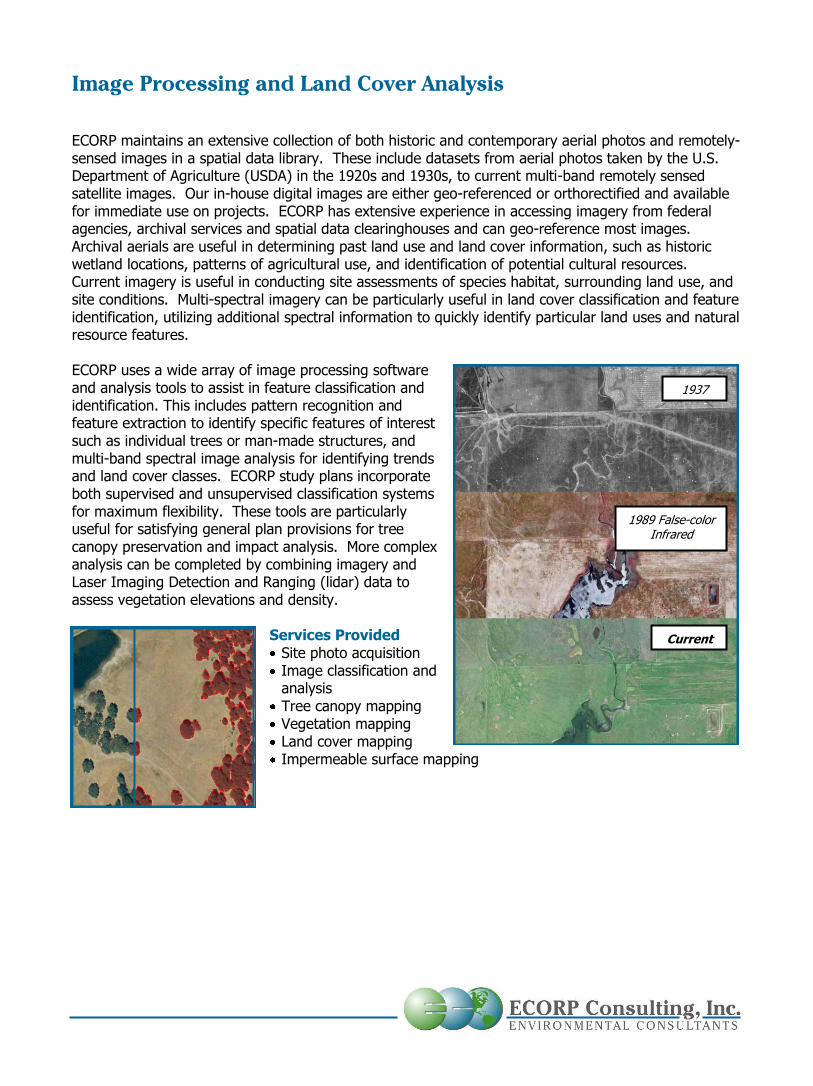
Image Processing and Land Cover Analysis
ECORP maintains an extensive collection of both historic and contemporary aerial photos and remotely-sensed images in a spatial data library. These include datasets from aerial photos taken by the U.S. Department of Agriculture (USDA) in the 1920s and 1930s, to current multi-band remotely sensed satellite images. Our in-house digital images are either geo-referenced or orthorectified and available for immediate use on projects. ECORP has extensive experience in accessing imagery from federal agencies, archival services and spatial data clearinghouses and can geo-reference most images. Archival aerials are useful in determining past land use and land cover information, such as historic wetland locations, patterns of agricultural use, and identification of potential cultural resources. Current imagery is useful in conducting site assessments of species habitat, surrounding land use, and site conditions. Multi-spectral imagery can be particularly useful in land cover classification and feature identification, utilizing additional spectral information to quickly identify particular land uses and natural resource features. ECORP uses a wide array of image processing software and analysis tools to assist in feature classification and identification. This includes pattern recognition and feature extraction to identify specific features of interest such as individual trees or man-made structures, and multi-band spectral image analysis for identifying trends and land cover classes. ECORP study plans incorporate both supervised and unsupervised classification systems for maximum flexibility. These tools are particularly useful for satisfying general plan provisions for tree canopy preservation and impact analysis. More complex analysis can be completed by combining imagery and Laser Imaging Detection and Ranging (lidar) data to assess vegetation elevations and density.
Services Provided
Site photo acquisition Image classification and analysis
Tree canopy mapping Vegetation mapping Land cover mapping Impermeable surface mapping
1937
1989 False-color Infrared
Current

Computer-Based Cartography
Maps are powerful visual tools for displaying study results in a clear and comprehensive format. For this reason, ECORP emphasizes high cartographic quality for all project graphics. The clarity, quality and usability of map products included in project documentation assists in relaying complex concepts to clients, regulatory agencies, and other interested parties. ECORP has extensive mapping capabilities and experience with vector and raster based mapping, construction and landscape plans, three-dimensional representations and renderings, and site illustrations. Additionally our mapping department has experience with animation creation, which is effective when graphically presenting results of analysis and modeling. ECORP offers advanced display capabilities for presentation and “on the fly” mapping exercise, bringing senior mapping staff together with clients, regulators, and other group members to quickly answer questions, analyze scenarios, and display results in a collaborative setting. Other mapping and data display services include web map preparation, and map and graphic creation for interpretive signs and educational materials. ECORP maintains in-house replication equipment for reproducing large format documents and maps, minimizing production time and cost. Services Provided Small and large format cartographic design Client directed real-time mapping and analysis
Data display in axonometric and oblique projections 3D representation of site conditions and analysis results Animations, walk- and fly-throughs