te - report - european aviation safety agency safety analysis.pdf · an increasing number of...
TRANSCRIPT
Safety Intelligence and Performance SM1.1
TE.GEN.00400-003 © European Aviation Safety Agency. All rights reserved. ISO9001 Certified. Proprietary document. Copies are not controlled. Confirm revision status through the EASA-Internet/Intranet.
An agency of the European Union
Safety Intelligence and Performance SM1.1
Report
UAS Safety Risk Portfolio and Analysis
UAS Safety Risk Portfolio and Analysis
Safety Intelligence and Performance SM1.1
TE.GEN.00400-003 © European Aviation Safety Agency. All rights reserved. ISO9001 Certified. Proprietary document. Copies are not controlled. Confirm revision status through the EASA-Internet/Intranet.
An agency of the European Union
Report
UAS Safety Risk Portfolio and Analysis
Document ref. Status Date
Contact name and address for enquiries: Yngvi Rafn Yngvason [email protected] European Aviation Safety Agency SM1.1 Safety Intelligence and Performance Postfach 10 12 53 50452 Köln Germany Information on EASA is available at: www.easa.europa.eu
Authorisation :
Name Signature Date
Prepared Yngvi Rafn Yngvason and Vincent Le Strat
24/06/2016
Reviewed 1 John Franklin 04/07/2016
Reviewed 2 (Optional)
Authorised (Optional)
Report Distribution List:
1
2
3
4
5
UAS Analysis
Safety Intelligence and Performance SM1.1
TE.GEN.00400-003 © European Aviation Safety Agency. All rights reserved. ISO9001 Certified. Proprietary document. Copies are not controlled. Confirm revision status through the EASA-Internet/Intranet.
An agency of the European Union
Executive Summary
The analysis in this paper seeks to identify the main safety risks involving Unmanned Aircraft System (UAS) operations. The Key Risk Areas (Outcomes) identified from the data were: - Airborne Conflict: The number of near-miss occurrences between drones and aircraft has increased significantly is the past 2 years. There have been a small number of collisions between drones and GA aircraft, thankfully with no fatalities or injuries so far. However, it should be noted that many of the reports of near-misses with UAS are uncomfirmed and might in fact involve other objects such as birds. Indeed, some of the reports of near-misses with UAS have occurred at altitudes where UAS are not normally able to operate. - Aircraft Upset. The 2nd Key Risk Area identified involved Aircraft Upset, which covers the full range of Loss of Control situations, which presents the potential for injuries to people on the ground. - System Failures. Both System/ Component Failure Powerplant and Non-Powerplant feature in the outcome types and therefore is also included in the Key Areas as it could also lead to injuries to people on the ground, especially in certain types of UAS operation. - Third Party Conflict. The final Key Risk Area covers the risk of UAS conflicts (collisions) with people or property (i.e. not involving aircraft) where they may cause injuries or damage. There were no occurrences involving such damage or injuries but expert judgement identified this as a key risk area that could occur through causes not associated with loss of control (Aircraft Upset) or technical failure in situations where a drone operator accidentally flies into people or property. The purpose of this paper is to identify the Key Risk Areas (Outcomes) and Safety Issues in UAS operations to form the basis of the UAS Safety Risk Portfolio.
UAS Analysis
Safety Intelligence and Performance SM1.1
TE.GEN.00400-003 © European Aviation Safety Agency. All rights reserved. ISO9001 Certified. Proprietary document. Copies are not controlled. Confirm revision status through the EASA-Internet/Intranet.
An agency of the European Union
1 Introduction
An increasing number of occurrences involving Unmanned Aircraft Systems (UAS) have hit the aviation world over the last couple of years. Small UAS for civil use are becoming easily available to commercial entities for use in a range of purposes, as well as to the general public with possibilities which are beyond anything previously foreseen. They introduce new risks to people and property on the ground as well as to other parts of the aviation system where potential Mid-Air Collisions pose a threat to passenger aircraft in particular. The scope of this paper covers all aspects of UAS usage from a safety risk perspective. The paper will specifically address the risk of collisions of UAS with other aircraft. However, deep and thorough technical discussion on the impact of such a collision is being handled by the RPAS Task Force (RPAS TF) launched in June 2016 by EASA and the industry and this paper will not cover these aspects.
2 Objective
The objective of the study is to better understand the safety risks posed by the growing use of UAS (both Commercial and Non-Commercial) to civil aviation and people on the ground. This specifically involves: - Understanding in detail the characteristics of “Airborne Conflict” occurrences. - Identifying the top Safety Issues contributing the risks of airborne conflict. The study uses two main sources of information. Firstly occurrence data has been taken from both the European Central Repository (occurrences reported to NAAs of the EASA Member States – including accidents) and also from airlines involved in EASA’s Commercial Air Transport (CAT) Aeroplanes Collaborative Analysis Group (CAG). Recent publicity of the risk of UAS collisions has meant that there are often occurrences reported as involving UAS that may well have been another object or a bird. In most cases it is very difficult to positively identify exactly if a UAS was involved. However, all such potential cases are included in this analysis.
3 Scope
3.1 Scope
The scope of this study includes UAS occurrence data for the time period from 2010 to May 2016 taken from EASA’s own occurrence database, European Central Repository (ECR1) data and data collected from NAAs and industry. The analysis covers:
1. Location of occurrences. 2. Aircraft type and drone type information where possible. 3. Operation type if known. 4. Occurrence class (Severity – i.e. accidents/ serious incident/ incident). 5. The identified Key Risk Areas (Outcomes). 6. Analysis of Event Types to enable the identification of Safety Issues. 7. Specific information on Mid Air Collision occurrences between aircraft and drones.
1 The European Central Repository is the European database where occurrences reported under Regulation (EU) 376/2014 are collected having been reported to the EASA Member States.
UAS Analysis
Safety Intelligence and Performance SM1.1
TE.GEN.00400-003 © European Aviation Safety Agency. All rights reserved. ISO9001 Certified. Proprietary document. Copies are not controlled. Confirm revision status through the EASA-Internet/Intranet.
An agency of the European Union
4 UAS – Types of Operation
Two main areas are identified within the UAS spectrum in terms of the types of operation. This is important because in the same way different safety activities are identified for Commercial Air Transport compared with Non-Commercial operations, the same is likely to be true for UAS. These areas are 1) the professional use of drones for various security, safety, survey and other tasks and 2) the recreational use where the general public are using drones for fun and private activities.
4.1 Commercial Operations
The professional domain can be split into 3 areas.
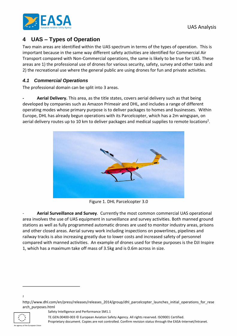
- Aerial Delivery. This area, as the title states, covers aerial delivery such as that being developed by companies such as Amazon Primeair and DHL, and includes a range of different operating modes whose primary purpose is to deliver packages to homes and businesses. Within Europe, DHL has already begun operations with its Parcelcopter, which has a 2m wingspan, on aerial delivery routes up to 10 km to deliver packages and medical supplies to remote locations2.
Figure 1. DHL Parcelcopter 3.0
- Aerial Surveillance and Survey. Currently the most common commercial UAS operational area involves the use of UAS equipment in surveillance and survey activities. Both manned ground stations as well as fully programmed automatic drones are used to monitor industry areas, prisons and other closed areas. Aerial survey work including inspections on powerlines, pipelines and railway tracks is also increasing greatly due to lower costs and increased safety of personnel compared with manned activities. An example of drones used for these purposes is the DJI Inspire 1, which has a maximum take off mass of 3.5kg and is 0.6m across in size.
2 http://www.dhl.com/en/press/releases/releases_2014/group/dhl_parcelcopter_launches_initial_operations_for_research_purposes.html

UAS Analysis
Safety Intelligence and Performance SM1.1
TE.GEN.00400-003 © European Aviation Safety Agency. All rights reserved. ISO9001 Certified. Proprietary document. Copies are not controlled. Confirm revision status through the EASA-Internet/Intranet.
An agency of the European Union
Figure 2. DJI Inspire 1
- Other Activities. Currently there are other activities where the use of drones is increasing or foreseen in the future. These include aerial agriculture for purposes such as crop spraying and surveillance to identify optimal harvest times. In addition drone racing is increasing in popularity involving internet audiences but it could be foreseen that this could become a more commercial activity involving paying audiences bringing people in close contact with UAS races.
4.2 Recreational Use
The general public has enthusiastically embraced UAS as a leisure activity. UAS sizes vary from few grams up to 3-4 kg. Attractive prices make drones easily accessible to people with little or no understanding of the aviation system, which creates challenges in terms of rules and regulations and EASA is currently addressing that issue. In addition, safety promotion is also a useful tool that can help to provide both the public and commercial operators with a better understanding of how to use UAS safely. EASA have already produced such promotional material and a video is already available on the EASA website3. In addition, it is important that for UAS that are sold to the general public are provided with clear instructions so that users of such drones are able to use them as safely as possible.
5 Overview Analysis
The overview analysis covers the annual breakdown of UAS occurrences in Europe since 2010. As much of this data comes from the ECR (Data from the EASA MS only), there are some challenges with regards to data quality such as the lack of narrative, which makes it hard to verify the data and some insufficient event coding. However, it is a good basis for a general overview.
3 https://www.easa.europa.eu/easa-and-you/civil-drones-rpas
UAS Analysis
Safety Intelligence and Performance SM1.1
TE.GEN.00400-003 © European Aviation Safety Agency. All rights reserved. ISO9001 Certified. Proprietary document. Copies are not controlled. Confirm revision status through the EASA-Internet/Intranet.
An agency of the European Union
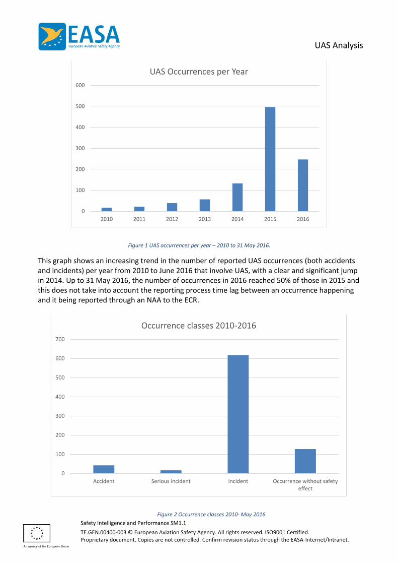
Figure 1 UAS occurrences per year – 2010 to 31 May 2016.
This graph shows an increasing trend in the number of reported UAS occurrences (both accidents and incidents) per year from 2010 to June 2016 that involve UAS, with a clear and significant jump in 2014. Up to 31 May 2016, the number of occurrences in 2016 reached 50% of those in 2015 and this does not take into account the reporting process time lag between an occurrence happening and it being reported through an NAA to the ECR.
Figure 2 Occurrence classes 2010- May 2016
0
100
200
300
400
500
600
2010 2011 2012 2013 2014 2015 2016
UAS Occurrences per Year
0
100
200
300
400
500
600
700
Accident Serious incident Incident Occurrence without safetyeffect
Occurrence classes 2010-2016

UAS Analysis
Safety Intelligence and Performance SM1.1
TE.GEN.00400-003 © European Aviation Safety Agency. All rights reserved. ISO9001 Certified. Proprietary document. Copies are not controlled. Confirm revision status through the EASA-Internet/Intranet.
An agency of the European Union
From these occurrences there were 42 accidents, the majority of which resulted from the crash of drone for either technical reasons or due to loss of control. None of these occurrences involved fatalities or injuries.
6 Identification of Key Risk Areas
The first stage in the development of the Safety Risk Portfolio involves the identification of the Key Risk Areas (Outcomes) that derive from the Occurrence Categories in the ECCAIRS Taxonomy4. From the analysis of the Occurrence Categories in Figure 3, the most common outcomes can be identified into the Key Risk Areas. Some of the actual Occurrence Categories are not outcomes, so these have been removed from the final Key Risk Areas, which are provided after the graph. Some of the Key Risk Areas are interlinked and may give rise to another outcome.
Figure 3 Occurrence Categories 2010- May 2016
- Airborne Conflict. Airborne conflict in the context of UAS covers specifically the risk of airborne collision between a drone and an aircraft in the air. Accounting for MAC/ Airprox and Navigation occurrences as well as a link to ATM/ ANS. Further analysis of this Key Risk Area will be covered later in Chapter 10. - Aircraft Upset. From the occurrence category analysis the 2nd Key Risk identified was Aircraft Upset, which covers the full range of Loss of Control situations. Whilst drone upsets (Loss of Control) are different to those involved other aircraft because there is no risk to persons on board the aircraft, there is a potential for injuries to people on the ground depending on the
4 The European Coordination Centre for Accident and Incident Reporting Systems is a software tool used by EASA and it’s Member States to collect safety occurrences. The taxonomy used in this software provides data structured in accordance with the ICAO taxonomies developed to enable global data sharing.
0 50 100 150 200 250
LALT: Low altitude operations
RE: Runway excursion
GCOL: Ground Collision
SEC: Security related
SCF-PP: powerplant failure or malfunction
ADRM: Aerodrome
SCF-NP: System/component failure or malfunction…
ATM: ATM/CNS
UNK: Unknown or undetermined
LOC-I: Loss of control - inflight
NAV: Navigation error
MAC: Airprox/ ACAS alert/ loss of separation/ (near)…
Occurrence Categories
UAS Analysis
Safety Intelligence and Performance SM1.1
TE.GEN.00400-003 © European Aviation Safety Agency. All rights reserved. ISO9001 Certified. Proprietary document. Copies are not controlled. Confirm revision status through the EASA-Internet/Intranet.
An agency of the European Union
planning of the flight and the reversion modes of the drone following a technical failure. Loss of control is particularly relevant for UAS as they are likely to operate in closer proximity to the ground than other types of aviation. - System Failures. Both System/ Component Failure Powerplant and Non-Powerplant feature in the outcome types and therefore would be included in the Key Risk Areas. For the purpose of the Safety Risk Portfolio this would be split into two areas. Firstly Engine Failure, which covers failure of the UAS propulsion system and secondly Other System Failures which includes both electrical and control systems as well as software and data link failures. - Third Party Conflict. The final Key Risk Area covers the risk of UAS conflicts (collisions) with people or property (i.e. not involving aircraft) where they may cause injuries or damage. There were no occurrences involving such damage or injuries but scenario based risk assessment has identified as a potential outcome that should be included as a key risk area for UAS operations. It is known that accidents involving UAS colliding with people on ground do happen, indeed such an event happened in the USA involving an UAS being used for media filming. However, none have been formally reported within the EASA MS. As the UAS industry is relatively new it could be possible that injuries due to drones are simply not reported on aviation level, but only in hospitals where the injuries are treated or at local law enforcement level. The initial Safety Risk Portfolio developed as part of the EASA Annual Safety Review 2016 is provided in Chapter 8 and within the Portfolio these Key Risk Areas are prioritised by their percentage involvement in the accidents in the analysis.
7 Identification of Safety Issues
The second part of analysis for the development of the Safety Risk Portfolio involves the identification of the Safety Issues that are associated with the different Key Risk Areas (Outcomes). Normally, this would involve a mainly quantitative analysis however due to the lack of detail in some of the UAS data, the analysis of Event Types can only provide some indications on possible Safety Issues. The identification of Safety Issues has been done in 2 stages. The first stage involves the initial analysis for the EASA Annual Safety Review, which combined the analysis of the Event Types and expert judgement within the Agency. The results of the first stage is captured in the Safety Risk Portfolio. In addition, since the completion of the Annual Safety Review, further work involving experts from various collaborative groups has led to a proposal for some additional Safety Issues to be included in the Safety Risk Portfolio. The subsequent analysis in this paper covers the identification of the Safety Issues in more detail. Figure 4 shows the initial Event Types analysis in which precursors to Airborne Conflict accidents unsurprisingly feature highly. These include Airspace infringements and Loss of Separation, as well as near collisions. The vast majority of the Safety Issues subsequently identified, and the analysis that follows, covers this outcome category.

UAS Analysis
Safety Intelligence and Performance SM1.1
TE.GEN.00400-003 © European Aviation Safety Agency. All rights reserved. ISO9001 Certified. Proprietary document. Copies are not controlled. Confirm revision status through the EASA-Internet/Intranet.
An agency of the European Union
Figure 4 UAS Occurrences 2010- May 2016 - Safety Events
8 UAS Safety Risk Portfolio
The initial UAS Safety Risk Portfolio provided below was published in the 2016 Annual Safety Review.
0 50 100 150 200 250
Uncommanded Movement of the Aircraft
Forced Landing
Interference by Other Activity
Collision with Level Terrain
ANS Traffic Information Provision
Separation Minima Infringement
Near Airborne Collision with RPAS
Near Airborne Collision with Other Airborne…
Loss of Separation
Interference by Model Aircraft
Airspace Infringement
Types of UAS Safety Events
UAS Analysis
Safety Intelligence and Performance SM1.1
TE.GEN.00400-003 © European Aviation Safety Agency. All rights reserved. ISO9001 Certified. Proprietary document. Copies are not controlled. Confirm revision status through the EASA-Internet/Intranet.
An agency of the European Union
It can be seen that 63% of occurrences are related to Airborne Conflict, which is the main Key Risk Area. This means that airspace infringements and proximity of drones to other aircraft is causing a significant number of occurrences. At this point it is worth noting that publicity of the potential for collisions with UAS has led to a number of unconfirmed near-misses with UAS. In the past many of these unconfirmed reports would have been cited as being near Birdstrikes. Both the Key Risk Areas on Airborne Conflict and Third Party Conflict will be covered in further detail later in the report. In terms of the Safety Issues in the initial Safety Risk Portfolio, which have been identified following the expert judgement discussion within the Agency, are summarised below: - Detection, Recognition and Recovery of Deviation from Normal Operations. The first Safety Issue, that was found most frequently in terms of accidents is related to the Key Risk Area of Aircraft Upset. It specifically relates to the operators’ ability to recognise and recover from abnormal aircraft attitudes. - UAS Handling and Flight Path Management. This Safety Issues is related to both Airborne Conflict and Aircraft Upset, as well as Third Party Conflict. It relates to both the normal handling of an RPAS and the planning and management of the flight path. There is also a relationship to the planning and preparation of RPAS operations. - UAS Infringement of Controlled Airspace/ UAS Proximity to Other Aircraft in Uncontrolled Airspace. The next Safety Issues in UAS involves the risk of a UAS either infringing controlled airspace or presenting a collision risk to other aircradt in uncontrolled airspace. Work to investigating the potential benefits of Geo-Fencing to prevent UAS flying into controlled airspace is already taking place. This Safety Issue is also linked to the Human Factors (HF) Safety Issues on UAS Operator Knowledge of the Aviation System. - Technical Safety Issues. Three technical Safety Issues have been identified from the analysis of occurrences and covers the failures of the guidance and control system, propulsion system and power sources. - Pre-Flight Planning and Preparation. The first HF Safety Issue for UAS involves the need for good pre-flight planning and preparation so that an UAS operator conducts any flight in a safe manner. As UAS operations involve many people that are unfamiliar with the aviation system, safety promotion will be important to make operators aware of good practices that they can easily follow. - UAS Operator Knowledge of the Aviation System. The second HF priority area is to ensure that anyone operating UAS who is new to aviation is able to easily learn about the aviation regulatory framework as it applies to UAS operations. - Maintenance/ Manufacturing. The final Safety Issue is related to the maintenance and manufacturing of UAS and further analysis work is required to consider this issue in more detail as minimal information was available from the analysis.
UAS Analysis
Safety Intelligence and Performance SM1.1
TE.GEN.00400-003 © European Aviation Safety Agency. All rights reserved. ISO9001 Certified. Proprietary document. Copies are not controlled. Confirm revision status through the EASA-Internet/Intranet.
An agency of the European Union
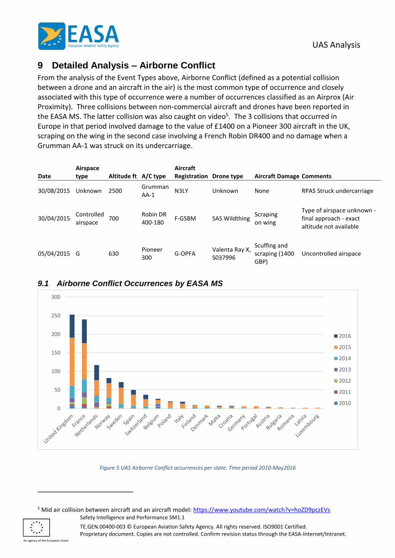
9 Detailed Analysis – Airborne Conflict
From the analysis of the Event Types above, Airborne Conflict (defined as a potential collision between a drone and an aircraft in the air) is the most common type of occurrence and closely associated with this type of occurrence were a number of occurrences classified as an Airprox (Air Proximity). Three collisions between non-commercial aircraft and drones have been reported in the EASA MS. The latter collision was also caught on video5. The 3 collisions that occurred in Europe in that period involved damage to the value of £1400 on a Pioneer 300 aircraft in the UK, scraping on the wing in the second case involving a French Robin DR400 and no damage when a Grumman AA-1 was struck on its undercarriage.
Date Airspace type Altitude ft A/C type
Aircraft Registration Drone type Aircraft Damage Comments
30/08/2015 Unknown 2500 Grumman AA-1
N3LY Unknown None RPAS Struck undercarriage
30/04/2015 Controlled airspace
700 Robin DR 400-180
F-GSBM SAS Wildthing Scraping on wing
Type of airspace unknown - final approach - exact altitude not available
05/04/2015 G 630 Pioneer 300
G-OPFA Valenta Ray X, S037996
Scuffing and scraping (1400 GBP)
Uncontrolled airspace
9.1 Airborne Conflict Occurrences by EASA MS
Figure 5 UAS Airborne Conflict occurrences per state. Time period 2010-May2016
5 Mid air collision between aircraft and an aircraft model: https://www.youtube.com/watch?v=hoZD9pczEVs
0
50
100
150
200
250
300
2016
2015
2014
2013
2012
2011
2010
UAS Analysis
Safety Intelligence and Performance SM1.1
TE.GEN.00400-003 © European Aviation Safety Agency. All rights reserved. ISO9001 Certified. Proprietary document. Copies are not controlled. Confirm revision status through the EASA-Internet/Intranet.
An agency of the European Union
Figure 5 shows the number of reported Airborne Conflict occurrences taken from the ECR which highlights the different numbers across the EASA MS. Further data is becoming available from other sources in individual States (such as from the ANSV – Accident Investigation Board Italy).. The data from operators collected through the CAT Aeroplanes CAG was used to cross-check the number of occurrences in different states.
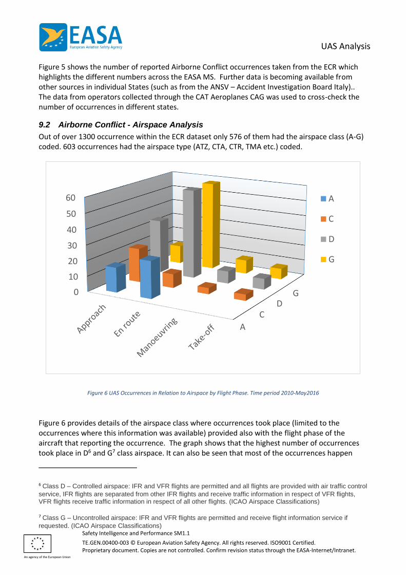
9.2 Airborne Conflict - Airspace Analysis
Out of over 1300 occurrence within the ECR dataset only 576 of them had the airspace class (A-G) coded. 603 occurrences had the airspace type (ATZ, CTA, CTR, TMA etc.) coded.
Figure 6 UAS Occurrences in Relation to Airspace by Flight Phase. Time period 2010-May2016
Figure 6 provides details of the airspace class where occurrences took place (limited to the occurrences where this information was available) provided also with the flight phase of the aircraft that reporting the occurrence. The graph shows that the highest number of occurrences took place in D6 and G7 class airspace. It can also be seen that most of the occurrences happen
6 Class D – Controlled airspace: IFR and VFR flights are permitted and all flights are provided with air traffic control
service, IFR flights are separated from other IFR flights and receive traffic information in respect of VFR flights, VFR flights receive traffic information in respect of all other flights. (ICAO Airspace Classifications)
7 Class G – Uncontrolled airspace: IFR and VFR flights are permitted and receive flight information service if
requested. (ICAO Airspace Classifications)
A
CD
G0
10
20
30
40
50
60 A
C
D
G
UAS Analysis
Safety Intelligence and Performance SM1.1
TE.GEN.00400-003 © European Aviation Safety Agency. All rights reserved. ISO9001 Certified. Proprietary document. Copies are not controlled. Confirm revision status through the EASA-Internet/Intranet.
An agency of the European Union
during Approach and during En route phases of the flight. It also needs to be considered that many occurrences do not have any airspace information coded which limits the usability of the data.
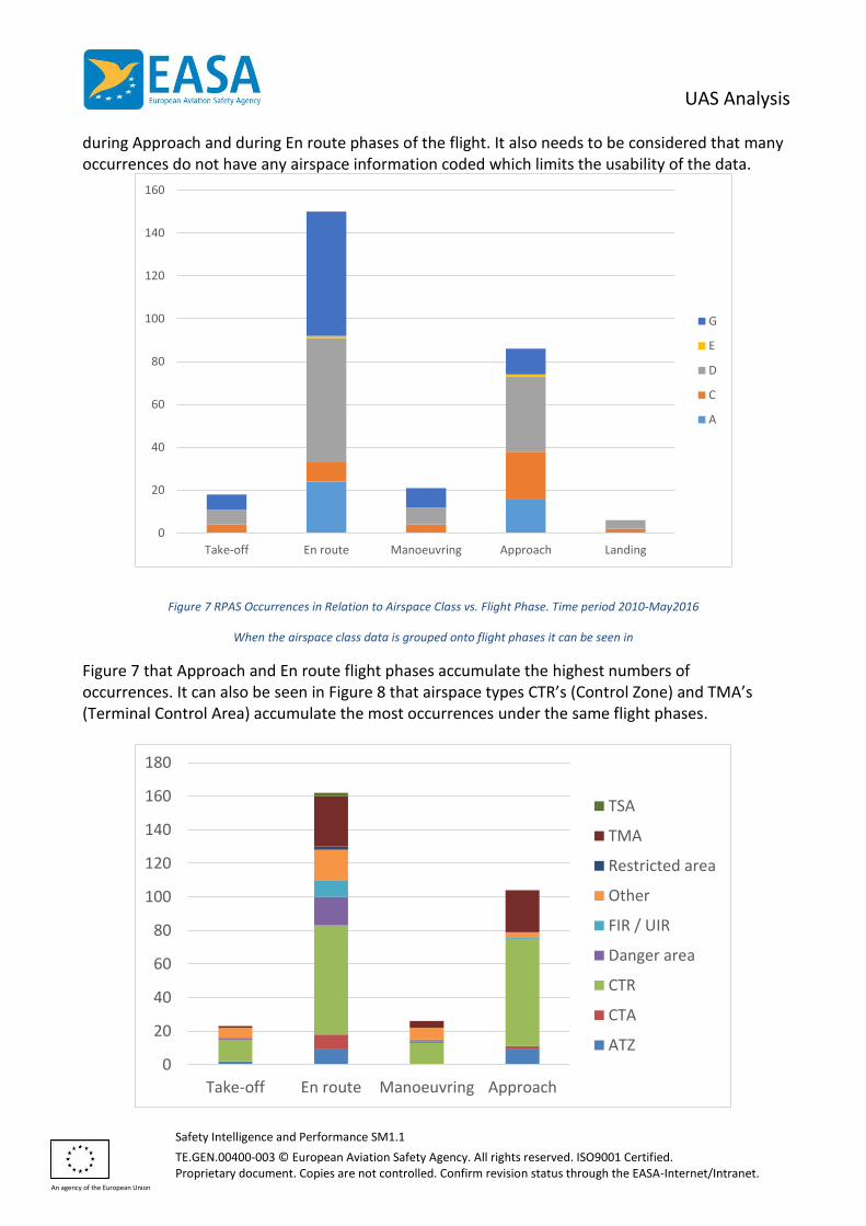
Figure 7 RPAS Occurrences in Relation to Airspace Class vs. Flight Phase. Time period 2010-May2016
When the airspace class data is grouped onto flight phases it can be seen in
Figure 7 that Approach and En route flight phases accumulate the highest numbers of occurrences. It can also be seen in Figure 8 that airspace types CTR’s (Control Zone) and TMA’s (Terminal Control Area) accumulate the most occurrences under the same flight phases.
0
20
40
60
80
100
120
140
160
Take-off En route Manoeuvring Approach Landing
G
E
D
C
A
0
20
40
60
80
100
120
140
160
180
Take-off En route Manoeuvring Approach
TSA
TMA
Restricted area
Other
FIR / UIR
Danger area
CTR
CTA
ATZ
UAS Analysis
Safety Intelligence and Performance SM1.1
TE.GEN.00400-003 © European Aviation Safety Agency. All rights reserved. ISO9001 Certified. Proprietary document. Copies are not controlled. Confirm revision status through the EASA-Internet/Intranet.
An agency of the European Union
Figure 8 Occurrences in Relation to Flight Phase vs. Airspace Type.
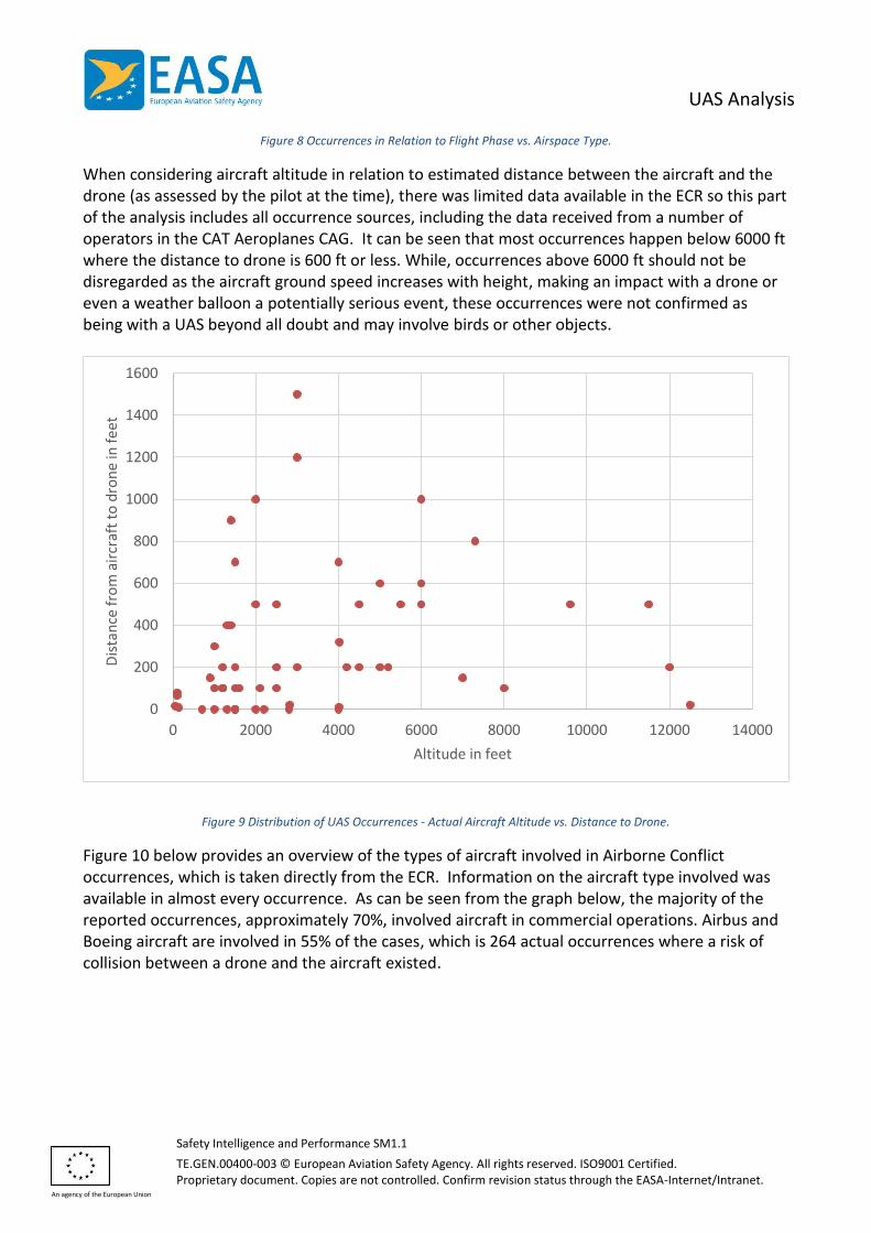
When considering aircraft altitude in relation to estimated distance between the aircraft and the drone (as assessed by the pilot at the time), there was limited data available in the ECR so this part of the analysis includes all occurrence sources, including the data received from a number of operators in the CAT Aeroplanes CAG. It can be seen that most occurrences happen below 6000 ft where the distance to drone is 600 ft or less. While, occurrences above 6000 ft should not be disregarded as the aircraft ground speed increases with height, making an impact with a drone or even a weather balloon a potentially serious event, these occurrences were not confirmed as being with a UAS beyond all doubt and may involve birds or other objects.
Figure 9 Distribution of UAS Occurrences - Actual Aircraft Altitude vs. Distance to Drone.
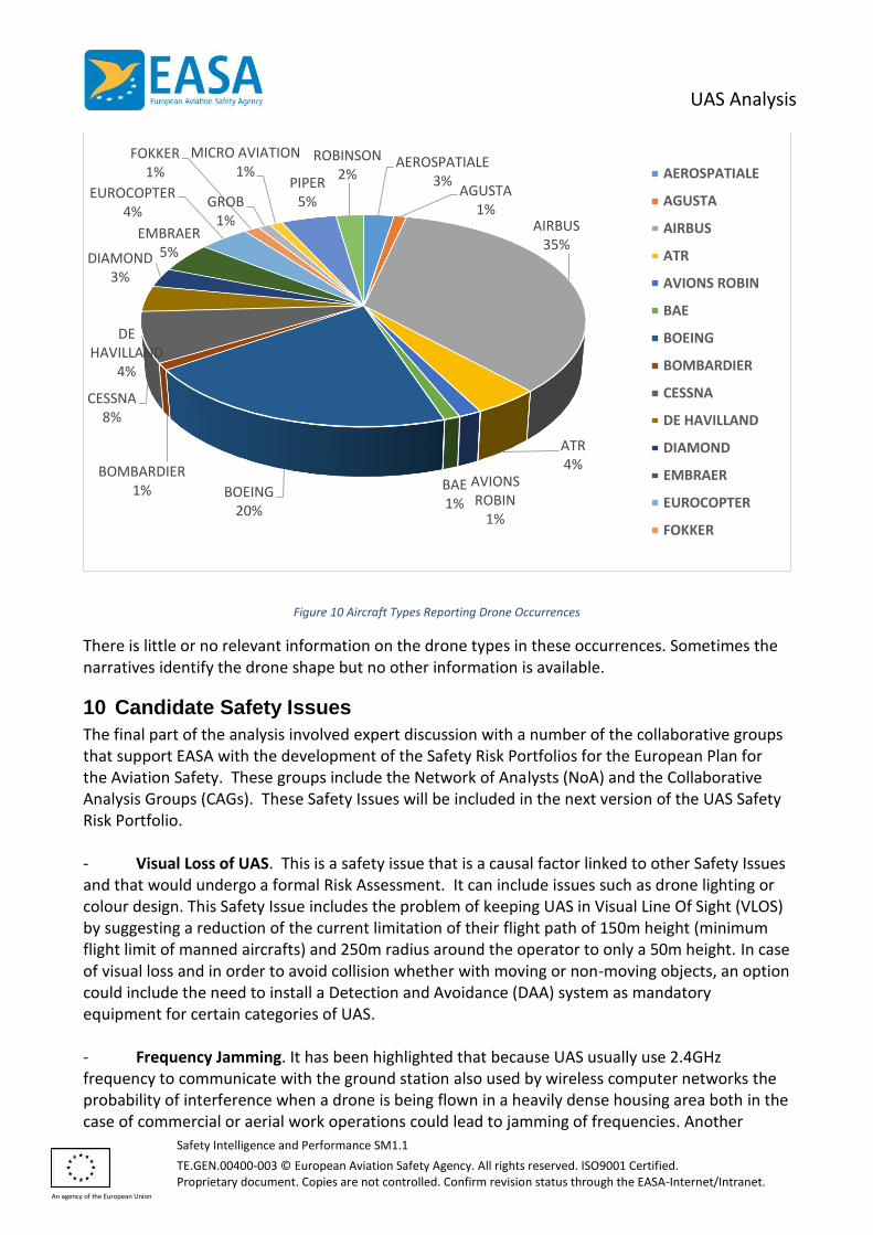
Figure 10 below provides an overview of the types of aircraft involved in Airborne Conflict occurrences, which is taken directly from the ECR. Information on the aircraft type involved was available in almost every occurrence. As can be seen from the graph below, the majority of the reported occurrences, approximately 70%, involved aircraft in commercial operations. Airbus and Boeing aircraft are involved in 55% of the cases, which is 264 actual occurrences where a risk of collision between a drone and the aircraft existed.
0
200
400
600
800
1000
1200
1400
1600
0 2000 4000 6000 8000 10000 12000 14000
Dis
tan
ce f
rom
air
craf
t to
dro
ne
in f
eet
Altitude in feet
UAS Analysis
Safety Intelligence and Performance SM1.1
TE.GEN.00400-003 © European Aviation Safety Agency. All rights reserved. ISO9001 Certified. Proprietary document. Copies are not controlled. Confirm revision status through the EASA-Internet/Intranet.
An agency of the European Union
Figure 10 Aircraft Types Reporting Drone Occurrences
There is little or no relevant information on the drone types in these occurrences. Sometimes the narratives identify the drone shape but no other information is available.
10 Candidate Safety Issues
The final part of the analysis involved expert discussion with a number of the collaborative groups that support EASA with the development of the Safety Risk Portfolios for the European Plan for the Aviation Safety. These groups include the Network of Analysts (NoA) and the Collaborative Analysis Groups (CAGs). These Safety Issues will be included in the next version of the UAS Safety Risk Portfolio. - Visual Loss of UAS. This is a safety issue that is a causal factor linked to other Safety Issues and that would undergo a formal Risk Assessment. It can include issues such as drone lighting or colour design. This Safety Issue includes the problem of keeping UAS in Visual Line Of Sight (VLOS) by suggesting a reduction of the current limitation of their flight path of 150m height (minimum flight limit of manned aircrafts) and 250m radius around the operator to only a 50m height. In case of visual loss and in order to avoid collision whether with moving or non-moving objects, an option could include the need to install a Detection and Avoidance (DAA) system as mandatory equipment for certain categories of UAS. - Frequency Jamming. It has been highlighted that because UAS usually use 2.4GHz frequency to communicate with the ground station also used by wireless computer networks the probability of interference when a drone is being flown in a heavily dense housing area both in the case of commercial or aerial work operations could lead to jamming of frequencies. Another
AEROSPATIALE3%
AGUSTA1%
AIRBUS35%
ATR4%
AVIONS ROBIN
1%
BAE1%
BOEING20%
BOMBARDIER1%
CESSNA8%
DE HAVILLAND
4%
DIAMOND3%
EMBRAER5%
EUROCOPTER4%
FOKKER1%
GROB1%
MICRO AVIATION1%
PIPER5%
ROBINSON2% AEROSPATIALE
AGUSTA
AIRBUS
ATR
AVIONS ROBIN
BAE
BOEING
BOMBARDIER
CESSNA
DE HAVILLAND
DIAMOND
EMBRAER
EUROCOPTER
FOKKER
UAS Analysis
Safety Intelligence and Performance SM1.1
TE.GEN.00400-003 © European Aviation Safety Agency. All rights reserved. ISO9001 Certified. Proprietary document. Copies are not controlled. Confirm revision status through the EASA-Internet/Intranet.
An agency of the European Union
possible problematic aspect raised is in regards to the operation of several drones in the same area at the same time when the radio allocated spectrum for drones is not wide enough to allow a huge amount of different drones operated by different operators. - UAS Task Management. Many UAS operate in a First Person View use mode, where the operator sees the equivalent view from the aircraft as if they were in a cockpit using a video link often using goggles. As this view is designed for flying the aircraft, it raises a risk during payload delivery because the pilot might be unsighted on where the payload is. In addition, when performing survey/ film work for example (as well as payload delivery) the operator must both fly the drone and concentrate on the task they are performing, which could cause a loss of control of the UAS during such critical phase of operation. This is a problem that could be addressed by considering the need for an extra observer for certain tasks. - UAS Hard Landings. Hard landings can cause extensive damages to UAS, as well as to both people and property in the surrounding area. Examples of near-missed drone crashes on civilians are getting more and more common8. Following such events, close inspection of the UAS is needed before future flights to ensure that it is still in a serviceable condition. - Instructions for Use of UAS equipment. It has been identified by UAS users that the User Manuals provided by UAS manufacturers are not up the standard they need to be. Hence, proper knowledge on the behaviour of individual systems and how they interact with other systems on board is not clearly laid out causing incidents of unexpected behaviour and in the worst cases loss of control.
11 Conclusion
The analysis in this paper seeks to identify the main safety risks involving UAS operations. The Key Risk Areas (Outcomes) identified from the data were: - Airborne Conflict: The number of reported near-miss occurrences between drones and aircraft has increased significantly is the past 2 years. There have been a small number of collisions between drones and GA aircraft, fortunately with no fatalities so far. However, it should be noted that many of the reports of near-misses with UAS are unconfirmed and might in fact involve other objects such as birds. Indeed, some of the reports of near-misses with UAS have occurred at altitudes where UAS are not normally able to operate. - Aircraft Upset. The 2nd Key Risk Area identified involved Aircraft Upset, which covers the full range of Loss of Control situations, which presents the potential for injuries to people on the ground. - System Failures. Both System/ Component Failure Powerplant and Non-Powerplant feature in the outcome types and therefore is also included in the Key Areas as it could also lead to injuries to people on the ground, especially in certain types of UAS operation.
8 Drone crash: https://www.youtube.com/watch?v=TJu4kmcy8gQ
UAS Analysis
Safety Intelligence and Performance SM1.1
TE.GEN.00400-003 © European Aviation Safety Agency. All rights reserved. ISO9001 Certified. Proprietary document. Copies are not controlled. Confirm revision status through the EASA-Internet/Intranet.
An agency of the European Union
- Third Party Conflict. The final Key Risk Area covers the risk of UAS conflicts (collisions) with people or property (i.e. not involving aircraft) where they may cause injuries or damage. There were no occurrences involving such damage or injuries but expert judgement identified this as a key risk area that could occur through causes not associated with loss of control (Aircraft Upset) or technical failure in situations where a drone operator accidentally flies into people or property.