tanana chiefs conference native allotment continuous ... · during the course of setting up the...
TRANSCRIPT

Tanana Chiefs Conference Native Allotment Continuous Forest Inventory Initiative Status Report, October 4, 2017 Will Putman, TCC Forestry Director Background There are approximately 2,714 Native allotment parcels covering 256,629 acres in the TCC Region, also referred to as the Doyon Management Unit by BIA and TCC Forestry. For management purposes, the region is split into 8 subunits. Previous stand-based forest inventories exist for the Native allotments, but are in need of updating. This project proposes to update the land cover typing on the Native allotment parcels as part of an inventory update process, but to focus additional field data collection on the establishment of permanently established continuous forest inventory (CFI) plots in order to establish a system of monitoring forest changes and growth in the context of climate change on allotment forest lands in the region. It is proposed to do this by accomplishing plot work in one subunit each year with a periodic remeasurement cycle of 10 years, continuing the project work indefinitely over time.
Initial funding for the project was provided in response to a request from the BIA in FY2014 intended to support forest inventory capacity building in the context of climate change on Native trust lands. Additional funding was acquired from the BIA in FY2015 in response to a similar RFP. Funding has also been provided by the BIA in FY2016 and FY2017 using Forest Management Inventory and Planning (FMIP) funds. The initial funding in FY2014 supported the initial design work and the 2015 field work in the Fairbanks Subunit. The funding acquired in FY2015 supported the sample and data processing from the 2015 field work, and the design work and the field work for the 2016 field work in the Delta Subunit. The FY2016 FMIP funds were used to process the data and samples collected in 2016, and to design and implement the 2017 field work in the McGrath Subunit. The FY2017 funds will be used to process the data and samples collected in 2017, to accomplish cover type updating in the Upper Yukon subunit and to design and implement the 2018 field work in the Upper Yukon Subunit.
U.S. Forest Service Partnership A key feature from the outset of TCC’s Continuous Forest Inventory initiative has been to collaborate as much as possible with other similar efforts in Interior Alaska, particularly an effort by the U.S. Forest Service to extend the Forest Inventory and Analysis program (FIA) into Interior Alaska. FIA is a standardized nationwide forest inventory and monitoring system across all land ownerships that essentially constitutes a national forest inventory. Because of past logistical and budgetary issues, Interior Alaska is the only major forested region of the United States that does not have a system of FIA plots installed; recent interest in the role of boreal forest ecosystems in global climate change has prompted the U.S. Forest Service to initiate the establishment of FIA plots in Interior Alaska.
To formalize our relationship with the USFS, TCC Forestry entered into a Memorandum of Cooperation in early 2017 that specifies the nature of our collaborative relationship. TCC’s partnership with the USFS has a number of key features:
• The USFS has provided technical assistance in sample design, which resulted in the adoption of FIA protocols for the TCC project.
• Under the terms of the agreement, the use of FIA protocols enables TCC to take full advantage of manuals, database designs, software tools, field data collection software and hardware, and training made available by the USFS.

• The data collected by TCC are incorporated into the larger FIA system as supplemental data, although TCC retains the right to deny use of the data for specified uses if required. In this way, TCC is able to contribute to the overall challenge of forest monitoring in Interior Alaska.
The Interior Alaska FIA effort was started in 2014 with a Tanana Valley Pilot Project, and involved the use of standard FIA data collection protocols modified for Interior Alaska. Production work on the Interior Alaska FIA started in 2016, with the USFS contracting much of the work to the State of Alaska, who hired personnel for several crews to install field plots. During the course of setting up the field work for the Interior Alaska FIA in 2017, a training session was held for field personnel in Fairbanks in May, and TCC staff were able to attend the training in preparation for the 2017 TCC CFI work.
Sample Design and Plot Selection
Initial outreach to USFS FIA resulted in collaboration with the National Inventory and Monitoring Applications Center (NIMAC), an office within FIA that is focused on providing technical assistance in designing and implementing monitoring and inventory systems. Technical assistance from NIMAC resulted in the adoption of FIA field data collection protocols for the TCC project, and the adoption of a system for determining the location of Native allotment sample locations.
Within a subunit that is subject to sampling in a given year, the sample frame is defined over those areas on Native allotments that have a suitable cover type and are feasibly and logistically accessible. A suitable cover type is any currently forested land cover type or a land cover type that could conceivably change to a forest type in the forseeable future in the context of climate change. Essentially, the only cover types excluded from inclusion in the sample frame were types consisting of water or persistently wet wetlands, cultural types (villages, roads, airstrips), or barren areas. Dry shrubland types were included in the potential sample area. Accessible parcels are identified as those parcels within 1 mile of a navigable river or highway, with possible additional access or logistical constraints imposed.
In the McGrath Subunit there are 158 Native allotment parcels comprising 13,331 acres. 108 parcels comprising 9,954 acres lie within 1 mile of a navigable river, but some additional access constraints were imposed for logistical concerns, reducing the number of accessible parcels to only 45 comprising 4,679 acres. On those parcels, there are 4,015 acres in suitable land cover types, and this is the area defining the sample area.
NIMAC provided access to a number of ArcGIS software tools that enabled running a plot selection process that uses a GIS and space-filling curves to create a sample frame of a grid of points over the sample area, superimpose a tessellation, and draw a sample. The result is a system that allows for random plot selection in a spatially balanced manner. A 30mx30m grid of potential plot locations was laid across the sample area. These potential plot locations were additionally filtered by excluding those points within 20m of an allotment boundary in an effort to ensure that the extent of selected plots is largely confined to trust land. For the 2017 work in the McGrath Subunit, the resulting grid contained 14,517 possible plot locations. The ArcGIS tool provided by NIMAC took those potential plot locations and grouped them into 20 clusters. Within each cluster, 1 plot was randomly selected by assigning a random number to each point in the sample frame grid and selecting the plot with the largest random number in each cluster. If a plot needed to be reselected because of permission issues, access, or other reasons, the plot with the next largest random number in each cluster was selected as the alternate selection.
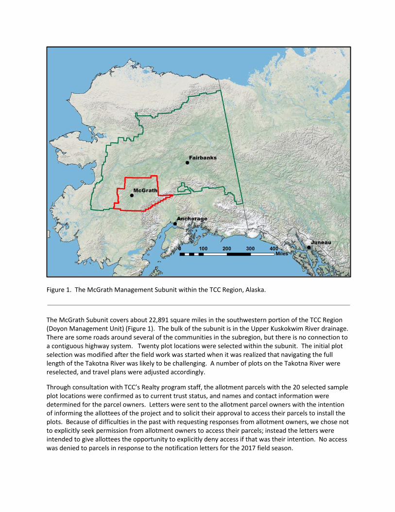
Figure 1. The McGrath Management Subunit within the TCC Region, Alaska.
The McGrath Subunit covers about 22,891 square miles in the southwestern portion of the TCC Region (Doyon Management Unit) (Figure 1). The bulk of the subunit is in the Upper Kuskokwim River drainage. There are some roads around several of the communities in the subregion, but there is no connection to a contiguous highway system. Twenty plot locations were selected within the subunit. The initial plot selection was modified after the field work was started when it was realized that navigating the full length of the Takotna River was likely to be challenging. A number of plots on the Takotna River were reselected, and travel plans were adjusted accordingly.
Through consultation with TCC’s Realty program staff, the allotment parcels with the 20 selected sample plot locations were confirmed as to current trust status, and names and contact information were determined for the parcel owners. Letters were sent to the allotment parcel owners with the intention of informing the allottees of the project and to solicit their approval to access their parcels to install the plots. Because of difficulties in the past with requesting responses from allotment owners, we chose not to explicitly seek permission from allotment owners to access their parcels; instead the letters were intended to give allottees the opportunity to explicitly deny access if that was their intention. No access was denied to parcels in response to the notification letters for the 2017 field season.
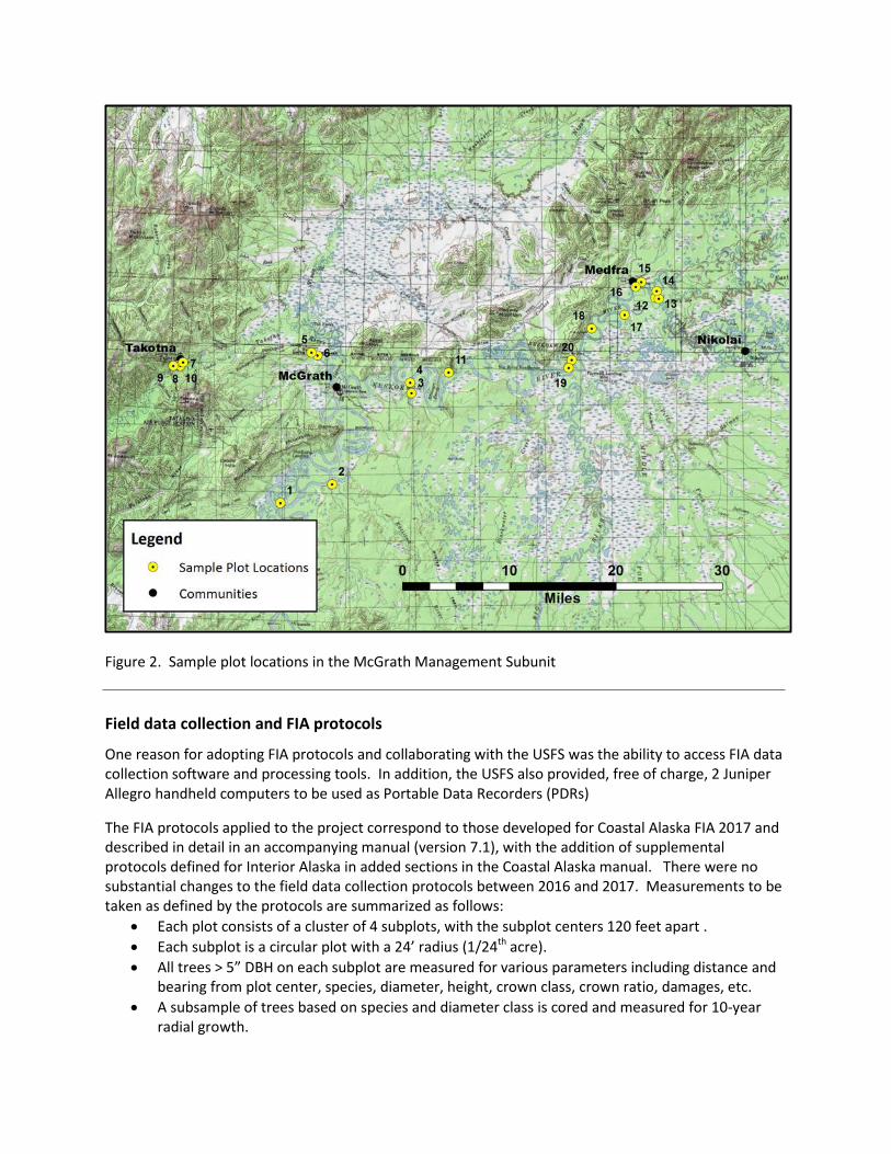
Figure 2. Sample plot locations in the McGrath Management Subunit
Field data collection and FIA protocols
One reason for adopting FIA protocols and collaborating with the USFS was the ability to access FIA data collection software and processing tools. In addition, the USFS also provided, free of charge, 2 Juniper Allegro handheld computers to be used as Portable Data Recorders (PDRs)
The FIA protocols applied to the project correspond to those developed for Coastal Alaska FIA 2017 and described in detail in an accompanying manual (version 7.1), with the addition of supplemental protocols defined for Interior Alaska in added sections in the Coastal Alaska manual. There were no substantial changes to the field data collection protocols between 2016 and 2017. Measurements to be taken as defined by the protocols are summarized as follows:
• Each plot consists of a cluster of 4 subplots, with the subplot centers 120 feet apart . • Each subplot is a circular plot with a 24’ radius (1/24th acre). • All trees > 5” DBH on each subplot are measured for various parameters including distance and
bearing from plot center, species, diameter, height, crown class, crown ratio, damages, etc. • A subsample of trees based on species and diameter class is cored and measured for 10-year
radial growth.
• Trees under 5” DBH are counted or measured on a circular microplot whose center is located 12’ at 90 degrees from each subplot center. Seedlings (trees , 1.0” DBH) are tallied on a 6.8’ radius (1/300th acre) circular plot. Trees 1.0” to 4.9” DBH (saplings) are tallied and measured on a 9.6’ radius (1/150th acre) circular plot. Dead saplings are included in the sample.
• On each subplot, 2 24’ transects are established. On each transect measurements are collected for:
o Fine, medium, and coarse down woody fuels (Brown’s transect techniques). o Litter and duff depths at the end of each transect. o Moss and lichen functional group coverage estimates on 4 microquad plots located
along each transect; this protocol is part of the Interior Alaska protocols described in the supplemental manual sections.
• On each subplot, vegetation structure is estimated by percent cover of functional group (tree, shrub, graminoid, forb) and layer, and percent cover of vegetation species is estimated for the 4 most dominant species within each functional group that is over 3% cover.
• As part of the Interior Alaska FIA protocols, soil sampling is conducted on subplots 1, 2, and 3: o Active layer depth measurements (4). o Litter depth measurements (4). o 12” radius sample of litter, collected and brought in from the field. o An extracted soil core that is measured for depth of organic soil layers, with collected
samples of each layer brought in from the field. • Over the plot area, several trees are sampled for site trees (species, height, diameter, age), and
several trees are sampled as age trees from the dominant tree species in the forest type on the plot.
All data collected were recorded using the PDRs, which were provided pre-loaded with MIDAS (Mobile Integrated Data Acquisition System) software. Subplot center locations and location of a reference point near each plot were recorded using a resource-grade GPS receiver (Trimble GeoXT 6000). These locations have been differentially corrected using post-processing techniques in the office, and the location data will be integrated with the plot data. The subplot centers were also referenced with witness trees which were measured and tagged. Subplot centers and microplot centers were marked with painted 1/2 ” rebar stakes. Tally trees on the subplots were measured for DBH at a height of 4.5’, but were marked with an aluminum nail facing plot center at a height of 4.0’ to avoid having the nail affect diameter measurements. As specified in FIA protocols, all bearings – from reference points to plot centers, from subplot centers to witness trees and subplot centers to tally trees, transect bearings, etc. – were taken in magnetic bearings.
To additionally document plot conditions, digital photographs were taken at each subplot center with a Ricoh Theta digital camera capable of shooting images with a view in all directions simultaneously. These images can be best viewed with an application available from Ricoh that enables scrolling the view of an image in any direction.
The location of the selected plots dictated 3 field trips to be undertaken (Figure 2). The first trip started by flying to Nikolai, assembling inflatable boats, traveling down the South Fork and main stem of the Kuskokwim, and accessing 9 plots from June 17 to June 27, 2017. Many of the plots accessed on that first trip were in the vicinity of Medfra. A second trip was taken July 10 to July 18, starting and ending in McGrath, where the boats and motors had been stored between the 1st and 2nd trip. 5 plots were visited on the 2nd trip accessed from the Kuskokwim River up and down river from McGrath. A 3rd trip was taken August 15 to August 24, flying to McGrath and returning to Fairbanks from Takotna at the end

of the trip. On the 3rd trip, 2 plots were accessed on the lower Takotna River by boating from McGrath, and then the crew chartered a flight from McGrath to Takotna and accessed 4 more plots from the village of Takotna using a rented boat. While traveling to and from McGrath, the inflatable boats and motors were stored at State of Alaska Division of Forestry facilities in McGrath. The chartered aircraft returning the crew to Fairbanks from Takotna at the end of the 3rd trip stopped in McGrath to retrieve the stored boats and motors.
The crew used to collect the field data was a combination of TCC Forestry and non-Forestry staff, 1 BIA personnel, and 1 State of Alaska FIA employee made available to TCC through a cooperative agreement established between TCC and State of Alaska Division of Forestry. On the 1st trip, the crew consisted of TCC forester Jeremy Douse, TCC surveyor Albert Macica, and BIA forester Josh Holte. The crew on the 2nd trip consisted of Jeremy Douse, Albert Macica, and TCC Archaeologist Bob Sattler. The crew on the 3rd trip consisted of Jeremy Douse, TCC Forestry Director Will Putman, and Jonathan Kummer, a State of Alaska seasonal employee that had worked on USFS FIA plots earlier in the season.
Field work in 2015 highlighted the need for TCC Forestry to upgrade or replace the boating equipment required to conduct remote river-based projects. To that end, a new Achilles inflatable boat and 25-horse 4-stroke outboard motor were purchased and used in the 2016 field season, and another Achilles inflatable boat and outboard motor were purchased in 2017; both of the new boats and motors were used to complete the field work in 2017.
Data Processing Data collected in 2016 was processed during the winter of 2016-17:
• Plot data files were transferred from the PDRs to a desktop computer. • Using MIDAS software utilities provided by the USFS, the plot data files were edited and cleaned
up for further processing. • The plot data files were transferred to the USFS; it is presumed that the data will be
incorporated as auxiliary plots in the USFS FIA system. • Staff at the USFS Forestry Sciences Lab in Anchorage (Vicki Johnson) took the TCC plot data files,
loaded the data into a MS Access database, and transferred the database to TCC. • The Access database was loaded into a SQL Server database on TCC’s network with as little
schema change to the database as possible. • Queries and reports developed previously are used to analyze and query the data, and
enhancements continue to be made to improve this capability. This may be enhanced in the future with direct access to USFS analytical tools.
As of this writing, the data collected in 2017 have been transferred into an Access database, and are awaiting integration into the SQL Server master database. The data can then be integrated with GIS feature classes already in place in a SQL Server geodatabase on the TCC system. GPS data collected for the plots have been post-processed and loaded into the geodatabase.
The soils samples collected in 2015 and 2016 were processed and analyzed by TCC Forestry staff in a soils lab at the University of Alaska Fairbanks (UAF) with the assistance of UAF personnel. The samples were analyzed for bulk density, and amounts of carbon and nitrogen, and the results stored in the SQL Server database. A similar process is planned for the 2017 soils samples; apparently, the UAF Forest Soils Lab is also being utilized to process identical soils sample collected by the USFS and State FIA crews.
Future Work At this point in time, FY2017 funding has been secured from BIA BOFRP to support Native Allotment CFI project work in FY2018, and it is our intention to secure additional funding on a year-to-year basis to continue the project by expanding CFI work into remaining subunits. GIS land cover update work will continue in front of CFI plot implementation by interpreting and classifying land cover on Native allotment parcels with available current satellite imagery and aerial photography.
The work associated with this project to date has been accomplished by professional staff at TCC with field work assistance from BIA staff, either BIA BOFRP or the BIA Alaska Region Office. One option for staffing for future field work would be to hire temporary employees or interns, preferably with tribal members from the TCC region. There have been discussions that TCC may be in the position to help build the labor force for the USFS Interior Alaska FIA work, and one option is to maintain a crew that could contract with the USFS for that work.
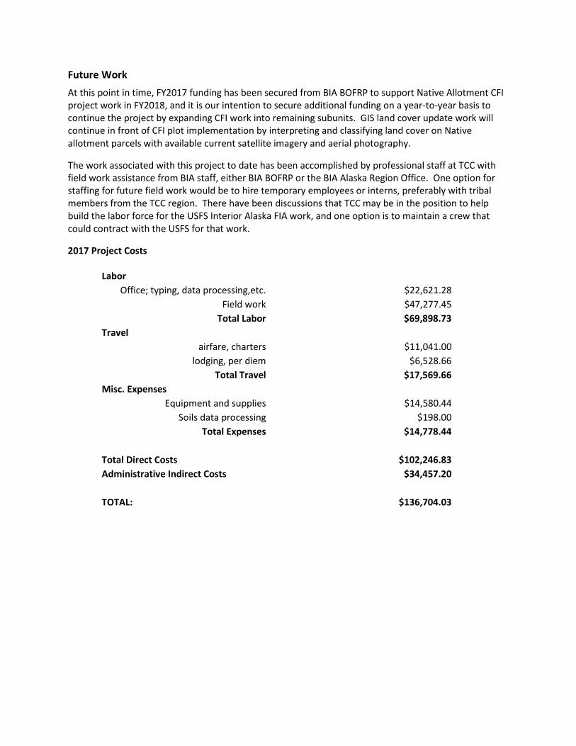
2017 Project Costs
Labor Office; typing, data processing,etc. $22,621.28
Field work $47,277.45 Total Labor $69,898.73
Travel airfare, charters $11,041.00
lodging, per diem $6,528.66 Total Travel $17,569.66
Misc. Expenses Equipment and supplies $14,580.44
Soils data processing $198.00 Total Expenses $14,778.44
Total Direct Costs $102,246.83 Administrative Indirect Costs $34,457.20
TOTAL: $136,704.03
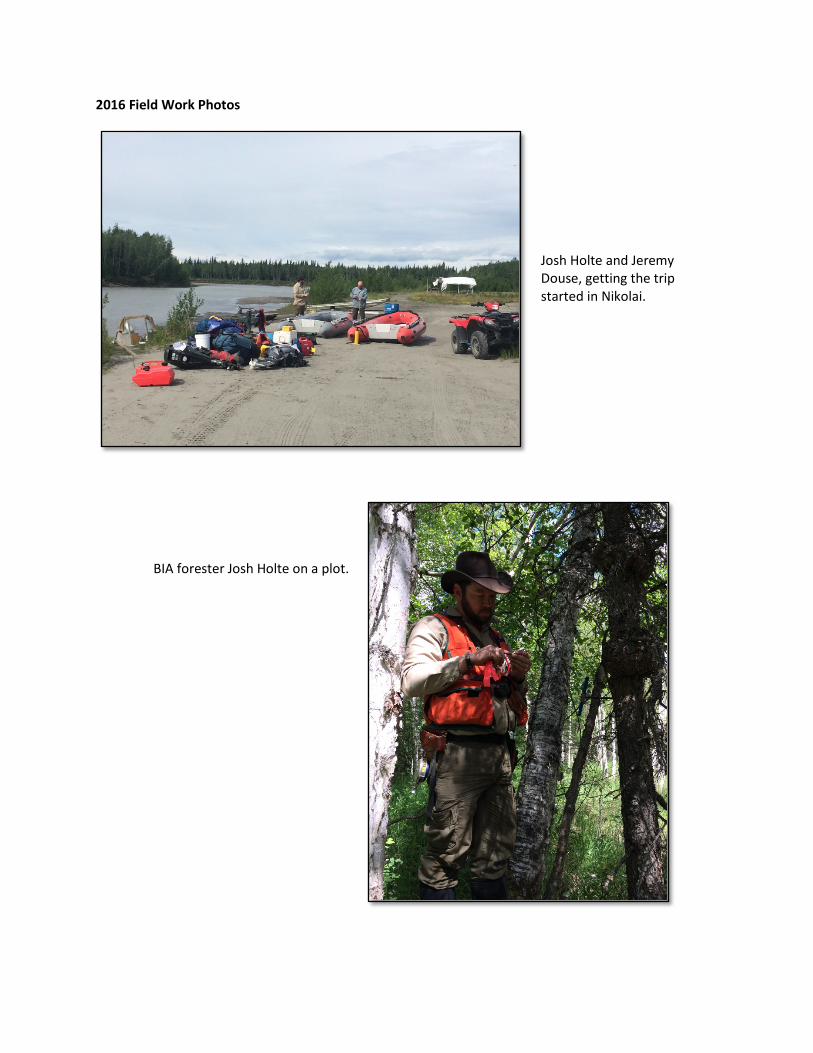
2016 Field Work Photos
Josh Holte and Jeremy Douse, getting the trip started in Nikolai.
BIA forester Josh Holte on a plot.
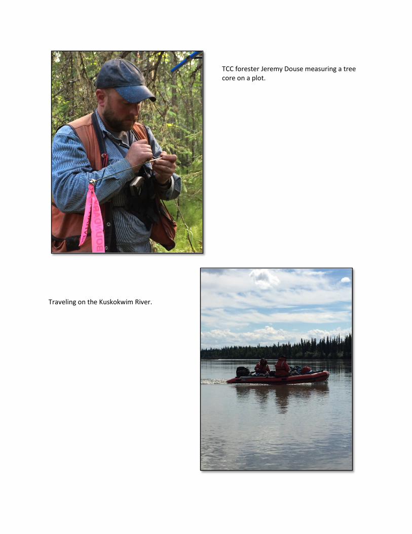
TCC forester Jeremy Douse measuring a tree core on a plot.
Traveling on the Kuskokwim River.

In Takotna.
TCC forester Jeremy Douse on a plot near Takotna.

Will Putman and Jonathan Kummer, travelling by boat on the Takotna River.
Organic soil sampling.