taking liberty by micahel s. coffman, phd...or into giving away a large portion of their property to...
TRANSCRIPT
30 • RANGE MAGAZINE • FALL 2005
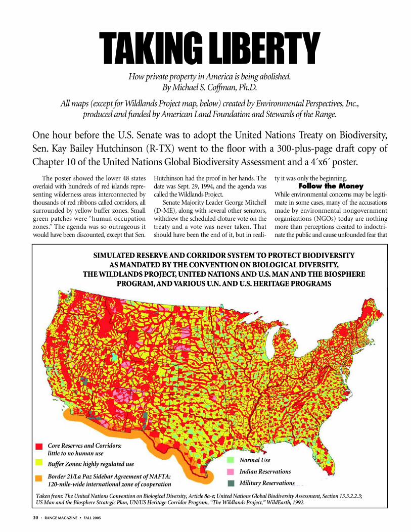
The poster showed the lower 48 statesoverlaid with hundreds of red islands repre-senting wilderness areas interconnected bythousands of red ribbons called corridors, allsurrounded by yellow buffer zones. Smallgreen patches were “human occupationzones.” The agenda was so outrageous itwould have been discounted, except that Sen.
Hutchinson had the proof in her hands. Thedate was Sept. 29, 1994, and the agenda wascalled the Wildlands Project.
Senate Majority Leader George Mitchell(D-ME), along with several other senators,withdrew the scheduled cloture vote on thetreaty and a vote was never taken. Thatshould have been the end of it, but in reali-
ty it was only the beginning.Follow the Money
While environmental concerns may be legiti-mate in some cases, many of the accusationsmade by environmental nongovernmentorganizations (NGOs) today are nothingmore than perceptions created to indoctri-nate the public and cause unfounded fear that
TAKING LIBERTYHow private property in America is being abolished.
By Michael S. Coffman, Ph.D.
All maps (except for Wildlands Project map, below) created by Environmental Perspectives, Inc.,produced and funded by American Land Foundation and Stewards of the Range.
Normal Use
Indian Reservations
Military Reservations
One hour before the U.S. Senate was to adopt the United Nations Treaty on Biodiversity,Sen. Kay Bailey Hutchinson (R-TX) went to the floor with a 300-plus-page draft copy ofChapter 10 of the United Nations Global Biodiversity Assessment and a 4´x6´ poster.
SIMULATED RESERVE AND CORRIDOR SYSTEM TO PROTECT BIODIVERSITYAS MANDATED BY THE CONVENTION ON BIOLOGICAL DIVERSITY,
THE WILDLANDS PROJECT, UNITED NATIONS AND U.S. MAN AND THE BIOSPHEREPROGRAM, AND VARIOUS U.N. AND U.S. HERITAGE PROGRAMS
Taken from: The United Nations Convention on Biological Diversity, Article 8a-e; United Nations Global Biodiversity Assessment, Section 13.3.2.2.3;US Man and the Biosphere Strategic Plan, UN/US Heritage Corridor Program, “The Wildlands Project,” WildEarth, 1992.
Core Reserves and Corridors: little to no human use
Buffer Zones: highly regulated use
Border 21/La Paz Sidebar Agreement of NAFTA:120-mile-wide international zone of cooperation
FALL 2005 • RANGE MAGAZINE • 31
generates income for the NGO. Environmen-tal fear has become a multibillion-dollar busi-ness that preys on unknowing urbanites.
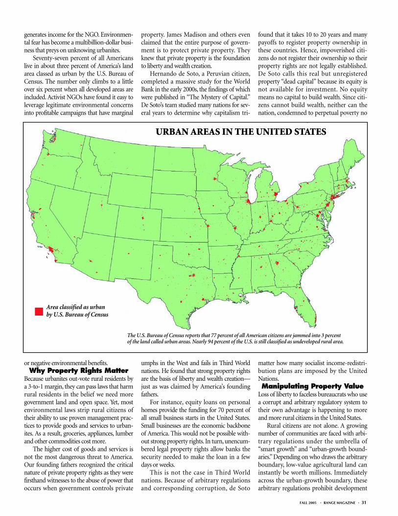
Seventy-seven percent of all Americanslive in about three percent of America’s landarea classed as urban by the U.S. Bureau ofCensus. The number only climbs to a littleover six percent when all developed areas areincluded. Activist NGOs have found it easy toleverage legitimate environmental concernsinto profitable campaigns that have marginal
or negative environmental benefits.Why Property Rights Matter
Because urbanites out-vote rural residents bya 3-to-1 margin, they can pass laws that harmrural residents in the belief we need moregovernment land and open space. Yet, mostenvironmental laws strip rural citizens oftheir ability to use proven management prac-tices to provide goods and services to urban-ites. As a result, groceries, appliances, lumberand other commodities cost more.
The higher cost of goods and services isnot the most dangerous threat to America.Our founding fathers recognized the criticalnature of private property rights as they werefirsthand witnesses to the abuse of power thatoccurs when government controls private
property. James Madison and others evenclaimed that the entire purpose of govern-ment is to protect private property. Theyknew that private property is the foundationto liberty and wealth creation.
Hernando de Soto, a Peruvian citizen,completed a massive study for the WorldBank in the early 2000s, the findings of whichwere published in “The Mystery of Capital.”De Soto’s team studied many nations for sev-eral years to determine why capitalism tri-
umphs in the West and fails in Third Worldnations. He found that strong property rightsare the basis of liberty and wealth creation—just as was claimed by America’s foundingfathers.
For instance, equity loans on personalhomes provide the funding for 70 percent ofall small business starts in the United States.Small businesses are the economic backboneof America. This would not be possible with-out strong property rights. In turn, unencum-bered legal property rights allow banks thesecurity needed to make the loan in a fewdays or weeks.
This is not the case in Third Worldnations. Because of arbitrary regulationsand corresponding corruption, de Soto
found that it takes 10 to 20 years and manypayoffs to register property ownership inthese countries. Hence, impoverished citi-zens do not register their ownership so theirproperty rights are not legally established.De Soto calls this real but unregisteredproperty “dead capital” because its equity isnot available for investment. No equitymeans no capital to build wealth. Since citi-zens cannot build wealth, neither can thenation, condemned to perpetual poverty no
matter how many socialist income-redistri-bution plans are imposed by the UnitedNations.Manipulating Property Value
Loss of liberty to faceless bureaucrats who usea corrupt and arbitrary regulatory system totheir own advantage is happening to moreand more rural citizens in the United States.
Rural citizens are not alone. A growingnumber of communities are faced with arbi-trary regulations under the umbrella of“smart growth” and “urban-growth bound-aries.” Depending on who draws the arbitraryboundary, low-value agricultural land caninstantly be worth millions. Immediatelyacross the urban-growth boundary, thesearbitrary regulations prohibit development
Area classified as urban by U.S. Bureau of Census
URBAN AREAS IN THE UNITED STATES
The U.S. Bureau of Census reports that 77 percent of all American citizens are jammed into 3 percent of the land called urban areas. Nearly 94 percent of the U.S. is still classified as undeveloped rural area.
32 • RANGE MAGAZINE • FALL 2005
and the value of the land remains low. Within100 yards, one landowner reaps millions andanother gets nothing. Arbitrary regulation—no matter how noble the intent—alwaysbreeds corruption.
Studies conducted by the Harvard Insti-tute of Economic Research clearly show thisenormous economic impact. Quarter-acrelots in cities with minimum smart-growthregulations average $10,000 to $40,000 perlot, while similar lots in cities imposing heavysmart-growth regulations average $200,000 to$600,000 per lot. There is a strong correlationbetween the time it takes to get a permit andthe cost of the land, just as de Soto found inThird World nations.
Harvard economists Edward L. Glaeserand Joseph Gyourko, in their paper “The
Impact of Zoning on Housing Affordability”(March 2002), emphasized that the entireincrease was due to smart-growth regula-tions. These “feel-good” regulations representa huge drag on future urban economy.
Little did I know when I prepared themap Sen. Hutchinson used on the Senatefloor, that environmental operatives werealready in key positions of our government,ready to implement the antiproperty rightsdirectives of the United Nations Treaty onBiodiversity. Although the treaty did not passthe Senate, they were able to shift gears, devel-oping the authority necessary to implementthe Wildlands agenda under an administra-tive cloak that didn’t require congressionalapproval. It has been just over 10 years sincethey actively began transforming Americainto a Wildlands. What is most frightening ishow much they have accomplished in thatshort period.
For anyone who doubts that environmen-talists are serious about destroying privateproperty in America, redistributing thewealth, and reducing the use of our naturalresources, those doubts should be put to rest.They are more than halfway there.
The Wildlands ProjectUnder the Wildlands Project, the UnitedStates would be transformed from a land
where people can live where they choose andtravel freely, to a Wildlands-dominated land-scape where people live in designated popula-tion centers with limited travel allowedthrough highly restricted corridors. TheWildlands Project is the master plan for boththe United Nations’ Agenda 21 and Biodiver-sity Treaty. In classic socialist utopian ideal-ism, Agenda 21 defines how every humanbeing must live in order to save mother earth.The Wildlands Project represents a grandiosedesign to transform at least half the land areaof the continental United States into animmense “eco-park” cleansed of modernindustry and private property.
Wildlands Project coauthor Reed Nossexplains their intent: “The collective needs ofnonhuman species must take precedence over
the needs and desires of humans.”Federal Programs
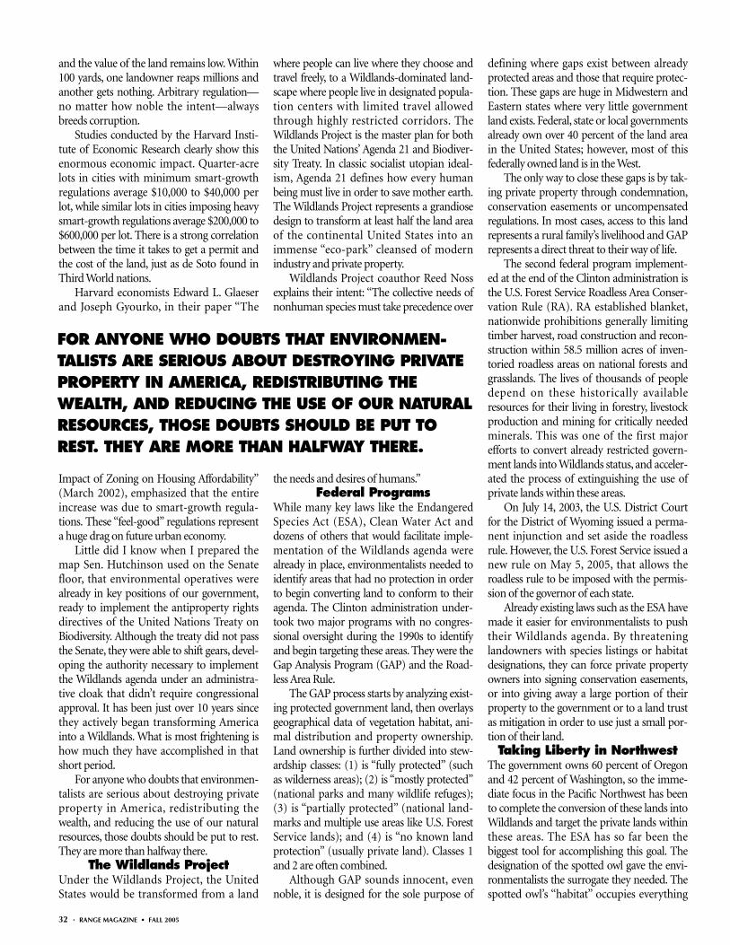
While many key laws like the EndangeredSpecies Act (ESA), Clean Water Act anddozens of others that would facilitate imple-mentation of the Wildlands agenda werealready in place, environmentalists needed toidentify areas that had no protection in orderto begin converting land to conform to theiragenda. The Clinton administration under-took two major programs with no congres-sional oversight during the 1990s to identifyand begin targeting these areas. They were theGap Analysis Program (GAP) and the Road-less Area Rule.
The GAP process starts by analyzing exist-ing protected government land, then overlaysgeographical data of vegetation habitat, ani-mal distribution and property ownership.Land ownership is further divided into stew-ardship classes: (1) is “fully protected” (suchas wilderness areas); (2) is “mostly protected”(national parks and many wildlife refuges);(3) is “partially protected” (national land-marks and multiple use areas like U.S. ForestService lands); and (4) is “no known landprotection” (usually private land). Classes 1and 2 are often combined.
Although GAP sounds innocent, evennoble, it is designed for the sole purpose of
defining where gaps exist between alreadyprotected areas and those that require protec-tion. These gaps are huge in Midwestern andEastern states where very little governmentland exists. Federal, state or local governmentsalready own over 40 percent of the land areain the United States; however, most of thisfederally owned land is in the West.
The only way to close these gaps is by tak-ing private property through condemnation,conservation easements or uncompensatedregulations. In most cases, access to this landrepresents a rural family’s livelihood and GAPrepresents a direct threat to their way of life.
The second federal program implement-ed at the end of the Clinton administration isthe U.S. Forest Service Roadless Area Conser-vation Rule (RA). RA established blanket,nationwide prohibitions generally limitingtimber harvest, road construction and recon-struction within 58.5 million acres of inven-toried roadless areas on national forests andgrasslands. The lives of thousands of peopledepend on these historically availableresources for their living in forestry, livestockproduction and mining for critically neededminerals. This was one of the first majorefforts to convert already restricted govern-ment lands into Wildlands status, and acceler-ated the process of extinguishing the use ofprivate lands within these areas.
On July 14, 2003, the U.S. District Courtfor the District of Wyoming issued a perma-nent injunction and set aside the roadlessrule. However, the U.S. Forest Service issued anew rule on May 5, 2005, that allows theroadless rule to be imposed with the permis-sion of the governor of each state.
Already existing laws such as the ESA havemade it easier for environmentalists to pushtheir Wildlands agenda. By threateninglandowners with species listings or habitatdesignations, they can force private propertyowners into signing conservation easements,or into giving away a large portion of theirproperty to the government or to a land trustas mitigation in order to use just a small por-tion of their land.
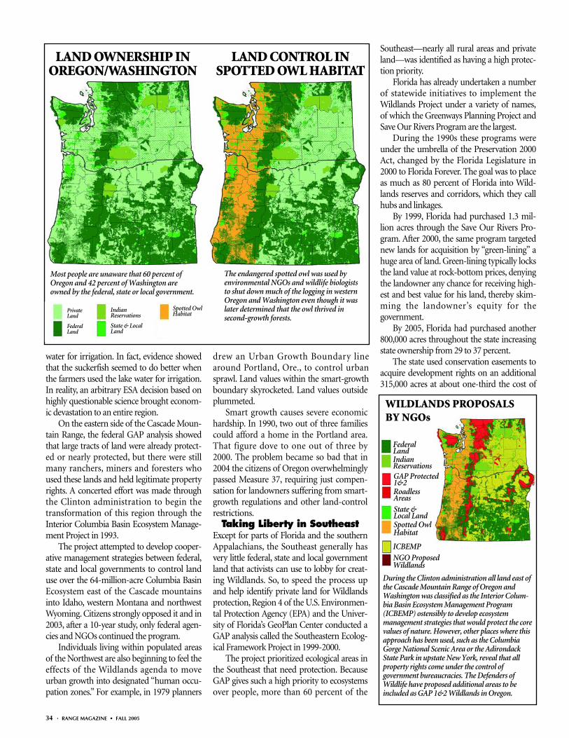
Taking Liberty in NorthwestThe government owns 60 percent of Oregonand 42 percent of Washington, so the imme-diate focus in the Pacific Northwest has beento complete the conversion of these lands intoWildlands and target the private lands withinthese areas. The ESA has so far been thebiggest tool for accomplishing this goal. Thedesignation of the spotted owl gave the envi-ronmentalists the surrogate they needed. Thespotted owl’s “habitat” occupies everything
FOR ANYONE WHO DOUBTS THAT ENVIRONMEN-TALISTS ARE SERIOUS ABOUT DESTROYING PRIVATEPROPERTY IN AMERICA, REDISTRIBUTING THEWEALTH, AND REDUCING THE USE OF OUR NATURALRESOURCES, THOSE DOUBTS SHOULD BE PUT TOREST. THEY ARE MORE THAN HALFWAY THERE.
west of the Cascade mountain range’s center-line, which includes large tracts of privateproperty. The intention was never to save thebird, but to make ghost towns out of entirecommunities.
The federal government, State of Oregonand environmental NGOs collaborated tocompletely shut down agriculture in the Kla-math Basin of south-central Oregon in 2001.Federal agents misrepresented the amount ofwater needed for endangered suckerfish inKlamath Lake, resulting in the loss of all irri-gation water to farmers in the basin andturning farmland into dustbowls. The envi-ronmental NGOs fulfilled their mission.
Even though their land essentiallybecame worthless, the State of Oregon didnothing to help the farmers. Thousands ofKlamath residents lost their jobs, and busi-nesses that supported farming faced financialruin. Later that summer, the National Acade-my of Sciences reviewed the data supportingthe court decision and found “no clear evi-dence” that high lake levels benefited the fishor “convincing scientific justification” for notallowing the farmers to continue to use the
FALL 2005 • RANGE MAGAZINE • 33
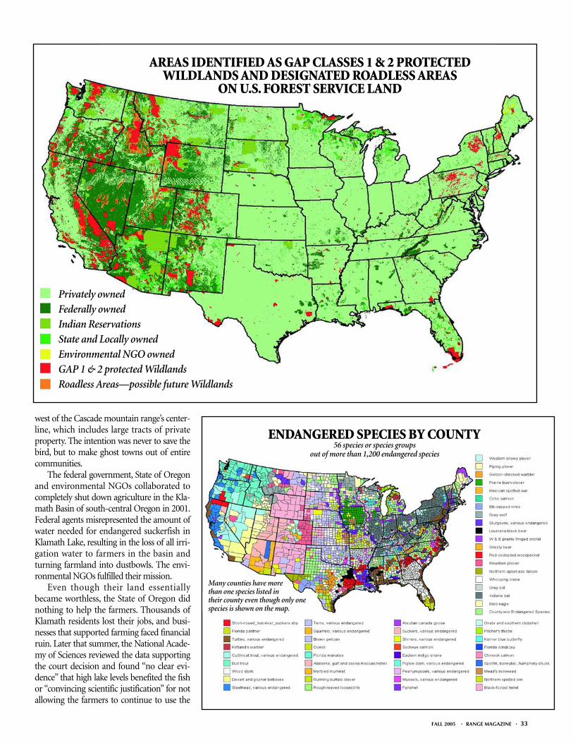
ENDANGERED SPECIES BY COUNTY56 species or species groups
out of more than 1,200 endangered species
Privately owned
Federally owned
Indian Reservations
State and Locally owned
Environmental NGO owned
GAP 1 & 2 protected Wildlands
Roadless Areas—possible future Wildlands
AREAS IDENTIFIED AS GAP CLASSES 1 & 2 PROTECTEDWILDLANDS AND DESIGNATED ROADLESS AREAS
ON U.S. FOREST SERVICE LAND
Many counties have morethan one species listed in their county even though only onespecies is shown on the map.
water for irrigation. In fact, evidence showedthat the suckerfish seemed to do better whenthe farmers used the lake water for irrigation.In reality, an arbitrary ESA decision based onhighly questionable science brought econom-ic devastation to an entire region.
On the eastern side of the Cascade Moun-tain Range, the federal GAP analysis showedthat large tracts of land were already protect-ed or nearly protected, but there were stillmany ranchers, miners and foresters whoused these lands and held legitimate propertyrights. A concerted effort was made throughthe Clinton administration to begin thetransformation of this region through theInterior Columbia Basin Ecosystem Manage-ment Project in 1993.
The project attempted to develop cooper-ative management strategies between federal,state and local governments to control landuse over the 64-million-acre Columbia BasinEcosystem east of the Cascade mountainsinto Idaho, western Montana and northwestWyoming. Citizens strongly opposed it and in2003, after a 10-year study, only federal agen-cies and NGOs continued the program.
Individuals living within populated areasof the Northwest are also beginning to feel theeffects of the Wildlands agenda to moveurban growth into designated “human occu-pation zones.” For example, in 1979 planners
drew an Urban Growth Boundary linearound Portland, Ore., to control urbansprawl. Land values within the smart-growthboundary skyrocketed. Land values outsideplummeted.
Smart growth causes severe economichardship. In 1990, two out of three familiescould afford a home in the Portland area.That figure dove to one out of three by2000. The problem became so bad that in2004 the citizens of Oregon overwhelminglypassed Measure 37, requiring just compen-sation for landowners suffering from smart-growth regulations and other land-controlrestrictions.
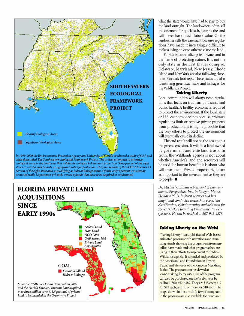
Taking Liberty in SoutheastExcept for parts of Florida and the southernAppalachians, the Southeast generally hasvery little federal, state and local governmentland that activists can use to lobby for creat-ing Wildlands. So, to speed the process upand help identify private land for Wildlandsprotection, Region 4 of the U.S. Environmen-tal Protection Agency (EPA) and the Univer-sity of Florida’s GeoPlan Center conducted aGAP analysis called the Southeastern Ecolog-ical Framework Project in 1999-2000.
The project prioritized ecological areas inthe Southeast that need protection. BecauseGAP gives such a high priority to ecosystemsover people, more than 60 percent of the
Southeast—nearly all rural areas and privateland—was identified as having a high protec-tion priority.
Florida has already undertaken a numberof statewide initiatives to implement theWildlands Project under a variety of names,of which the Greenways Planning Project andSave Our Rivers Program are the largest.
During the 1990s these programs wereunder the umbrella of the Preservation 2000Act, changed by the Florida Legislature in2000 to Florida Forever. The goal was to placeas much as 80 percent of Florida into Wild-lands reserves and corridors, which they callhubs and linkages.
By 1999, Florida had purchased 1.3 mil-lion acres through the Save Our Rivers Pro-gram. After 2000, the same program targetednew lands for acquisition by “green-lining” ahuge area of land. Green-lining typically locksthe land value at rock-bottom prices, denyingthe landowner any chance for receiving high-est and best value for his land, thereby skim-ming the landowner’s equity for thegovernment.
By 2005, Florida had purchased another800,000 acres throughout the state increasingstate ownership from 29 to 37 percent.
The state used conservation easements toacquire development rights on an additional315,000 acres at about one-third the cost of
34 • RANGE MAGAZINE • FALL 2005
During the Clinton administration all land east ofthe Cascade Mountain Range of Oregon andWashington was classified as the Interior Colum-bia Basin Ecosystem Management Program(ICBEMP) ostensibly to develop ecosystemmanagement strategies that would protect the corevalues of nature. However, other places where thisapproach has been used, such as the ColumbiaGorge National Scenic Area or the AdirondackState Park in upstate New York, reveal that allproperty rights come under the control ofgovernment bureaucracies. The Defenders ofWildlife have proposed additional areas to beincluded as GAP 1&2 Wildlands in Oregon.
LAND OWNERSHIP IN OREGON/WASHINGTON
LAND CONTROL IN SPOTTED OWL HABITAT
Most people are unaware that 60 percent ofOregon and 42 percent of Washington areowned by the federal, state or local government.
The endangered spotted owl was used byenvironmental NGOs and wildlife biologiststo shut down much of the logging in westernOregon and Washington even though it waslater determined that the owl thrived insecond-growth forests.
WILDLANDS PROPOSALS BY NGOs
Federal LandIndianReservationsGAP Protected1&2Roadless Areas
State & Local LandSpotted OwlHabitat
ICBEMP
NGO ProposedWildlands
PrivateLand
FederalLand
IndianReservations
State & LocalLand
Spotted OwlHabitat
FALL 2005 • RANGE MAGAZINE • 35
what the state would have had to pay to buythe land outright. The landowners often sellthe easement for quick cash, figuring the landwill never have much future value. Or thelandowner sells the easement because regula-tions have made it increasingly difficult tomake a living on or to otherwise use the land.
Florida is cannibalizing its private land inthe name of protecting nature. It is not theonly state in the East that is doing so.Delaware, Maryland, New Jersey, RhodeIsland and New York are also following close-ly in Florida’s footsteps. These states are alsoidentifying greenway hubs and linkages forthe Wildlands Project.
Taking LibertyLocal communities will always need regula-tions that focus on true harm, nuisance andpublic health. A healthy economy is requiredto protect the environment. If the local, stateor U.S. economy declines because arbitraryregulations limit or remove private propertyfrom production, it is highly probable thatthe very efforts to protect the environmentwill eventually cause its decline.
The end result will not be the eco-utopiathe greens envision. It will be a land ownedby government and elite land trusts. Intruth, the Wildlands agenda is not aboutwhether America’s land and resources willbe used for human benefit; it is about whowill own them. Private property rights areas important to the environment as they areto people. ■
Dr. Michael Coffman is president of Environ-mental Perspectives, Inc., in Bangor, Maine.He has a Ph.D. in forest sciences and hastaught and conducted research in ecosystemclassification, global warming and acid rain for25 years before founding Environmental Per-spectives. He can be reached at 207-945-9878.
In 1999-2000 the Environmental Protection Agency and University of Florida conducted a study of GAP andother data called The Southeastern Ecological Framework Project. The project attempted to prioritizeecological areas in the Southeast that wildlands ecologists believe need protection. Sixty percent of the eightstates received a high priority or significant status for protection. The final resulsts of the SEFP delineated 43percent of the eight-state area as qualifying as hubs or linkage status. Of this, only 9 percent was alreadyprotected while 52 percent is privately owned uplands that have to be acquired or condemned.
Taking Liberty on the Web!“Taking Liberty” is a sophisticated Web-basedanimated program with narrations and stun-ning visuals showing the progress environmen-talists have made and what programs they areusing in their efforts to implement the radicalWildlands agenda. It is funded and produced bythe American Land Foundation in Taylor,Texas, and Stewards of the Range in Meridian,Idaho. The program can be viewed at<www.takingliberty.us>. CDs of the programcan also be purchased on the Web site or bycalling 1-800-452-6389. They are $15 each; 4-9for $12 each; and 10 or more for $10 each. Themaps shown in this article (a few of many) andin the program are also available for purchase.
SOUTHEASTERN
ECOLOGICAL
FRAMEWORK
PROJECT
Priority Ecological Areas
Significant Ecological Areas
FLORIDA PRIVATE LAND ACQUISITIONS SINCE EARLY 1990s
Since the 1990s the Florida Preservation 2000and the Florida Forever Programs have acquiredover three million acres (11.5 percent) of privateland to be included in the Greenways Project.
GOALFuture WildlandHubs & Linkages
Federal LandState LandNGO LandGAP Status 1&2Private LandAcquisitions