tables - department of natural resources · tables 143 . tittabawassee river assessment 144 this...
TRANSCRIPT

TABLES
143

Tittabawassee River Assessment
144
This page was intentionally left blank.

Tittabawassee River Assessment
145
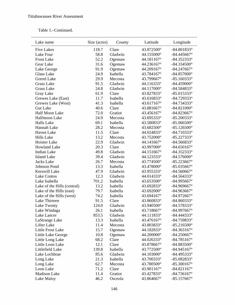
Table 1.–Name, size, and location of lakes and impoundments 10 acres or greater in the Tittabawassee River watershed.
Lake name Size (acres) County Latitude Longitude
Arnold Lake 121.3 Clare 44.069500° -84.752000° Atchel Lake 16.3 Roscommon 44.183500° -84.520333° Bailey Lake 38.3 Clare 43.891667° -84.651500° Barrytown 46.7 Mecosta 43.746333° -85.146667° Bass Lake 101.1 Montcalm 43.402500° -84.927333° Bass Lake 55.8 Clare 43.867500° -85.072667° Beebe Lake 49.7 Clare 43.945500° -84.759000° Bentley Marsh 303.3 Gladwin 44.014333° -84.170500° Bertha Lake 35.7 Clare 43.932167° -84.892667° Big Cranberry Lake 310.5 Clare 43.883000° -85.038667° Big Eldred Lake 12.0 Isabella 43.598000° -85.070667° Big Mud Lake 230.9 Clare 43.900333° -85.074333° Blanchard Millpond 14.9 Isabella 43.523333° -85.075167° Blue Lake 24.4 Gladwin 44.122500° -84.561167° Bluegill Lake 11.7 Mecosta 43.697000° -85.226000° Bluff Lake 41.8 Clare 43.833000° -84.977333° Boathouse Lake 50.0 Clare 44.025500° -84.722000° Boyles Creek 287.7 Clare 43.847500° -85.014833° Brine Pond 868.6 Midland 43.576000° -84.221333° Brine ponds 375.9 Midland 43.590167° -84.237333° Budd Lake 173.7 Clare 44.020333° -84.794333° Bungo Lake 18.7 Clare 43.940333° -84.910333° Camelot Lake 55.6 Isabella 43.584333° -84.610167° Campbell Lake 14.8 Roscommon 44.191833° -84.045833° Cedar Lake 10.2 Gladwin 44.137500° -84.349500° Chatman Lake 61.2 Ogemaw 44.167500° -84.341000° Chippewa Lake 791.3 Mecosta 43.754500° -85.298167° Clear Lake 52.4 Clare 43.894167° -84.941500° Clear Lake 65.8 Roscommon 44.230000° -84.488167° Coldwater Lake 285.3 Isabella 43.661167° -84.956000° Cranberry Lake 162.9 Clare 44.057500° -84.743667° Deaner Lake 25.4 Montcalm 43.392167° -84.875667° Deer Lake 19.1 Clare 44.020833° -84.757333° Diamond Lake 85.7 Mecosta 43.723000° -85.204500° Dodge Lake 23.4 Clare 44.021333° -84.712833° Dunham Lake 19.1 Roscommon 44.209667° -84.403667° East Twin Lake (East) 16.5 Roscommon 44.246667° -84.451000° East Twin Lake (West) 52.9 Roscommon 44.246167° -84.456000° Eddy Lake 18.7 Roscommon 44.239833° -84.465167° Edwards Lake 56.0 Ogemaw 44.193833° -84.304000° Eight Point Lake 415.6 Clare 43.840000° -85.073500° Elbow Lake 23.7 Clare 44.134167° -84.662000° Elk Lake 68.3 Gladwin 44.157833° -84.359833° Emerald Lake 13.6 Mecosta 43.800833° -85.247333° Lake Enola 17.9 Clare 43.932833° -84.752333° Eureka Lake 14.3 Clare 43.926333° -84.881667°
Tittabawassee River Assessment
146
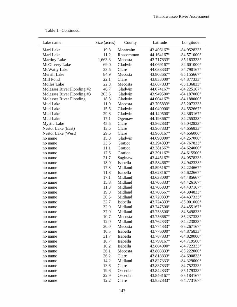
Table 1.–Continued.
Lake name Size (acres) County Latitude Longitude
Five Lakes 118.7 Clare 43.872500° -84.801833° Lake Four 58.8 Gladwin 44.155000° -84.445667° Frost Lake 52.2 Ogemaw 44.181167° -84.352333° Gear Lake 31.6 Ogemaw 44.236167° -84.334500° Lake George 91.9 Ogemaw 44.209167° -84.247667° Glass Lake 24.9 Isabella 43.784167° -84.857000° Gorrel Lake 29.9 Mecosta 43.799667° -85.160333° Grass Lake 91.5 Gladwin 44.116333° -84.459000° Grass Lake 24.8 Gladwin 44.117000° -84.584833° Gray Lake 61.9 Clare 43.827833° -85.015333° Grewes Lake (East) 11.7 Isabella 43.616833° -84.729333° Grewes Lake (West) 41.3 Isabella 43.617167° -84.734333° Gut Lake 40.6 Clare 43.881667° -84.821000° Half Moon Lake 72.0 Gratiot 43.456167° -84.823667° Halfmoon Lake 24.9 Mecosta 43.695333° -85.200333° Halls Lake 69.1 Isabella 43.580833° -85.066500° Hannah Lake 28.2 Mecosta 43.682500° -85.126500° Haven Lake 11.5 Clare 44.024833° -84.710333° Hills Lake 13.2 Mecosta 43.752000° -85.227333° Hoister Lake 22.9 Gladwin 44.141667° -84.566833° Howland Lake 20.3 Clare 43.997000° -84.650167° Indian Lake 49.8 Gladwin 44.151667° -84.352333° Island Lake 39.4 Gladwin 44.123333° -84.576000° Jacks Lake 26.7 Mecosta 43.774500° -85.223667° Johnson Pond 13.3 Isabella 43.478000° -85.035667° Kerswill Lake 47.9 Gladwin 43.955333° -84.560667° Lake Contos 12.3 Gladwin 44.014333° -84.564333° Lake Isabella 701.2 Isabella 43.653500° -84.995667° Lake of the Hills (central) 13.2 Isabella 43.692833° -84.969667° Lake of the Hills (east) 79.7 Isabella 43.692000° -84.963667° Lake of the Hills (west) 74.2 Isabella 43.694167° -84.972667° Lake Thirteen 91.5 Clare 43.860833° -84.860333° Lake Twenty 124.0 Gladwin 43.940500° -84.578333° Lake Windaga 26.1 Isabella 43.718667° -84.997667° Lake Lancer 853.5 Gladwin 44.111833° -84.444333° LaStrange Lake 13.3 Isabella 43.476167° -84.759833° Lifter Lake 11.4 Mecosta 43.803833° -85.216500° Little Frost Lake 15.7 Ogemaw 44.182833° -84.363167° Little Lake George 10.8 Ogemaw 44.200000° -84.250667° Little Long Lake 68.2 Clare 44.026333° -84.785167° Little Loon Lake 12.1 Clare 43.878667° -84.883500° Littlefield Lake 139.8 Isabella 43.772500° -84.945167° Lake Lochbrae 85.6 Gladwin 44.103000° -84.495333° Long Lake 21.3 Isabella 43.700333° -85.082833° Long Lake 62.7 Mecosta 43.780500° -85.300167° Loon Lake 71.2 Clare 43.901167° -84.821167° Madison Lake 11.4 Gratiot 43.427833° -84.736167° Lake Maloy 46.2 Osceola 43.864667° -85.157667°
Tittabawassee River Assessment
147
Table 1.–Continued.
Lake name Size (acres) County Latitude Longitude
Marl Lake 19.3 Montcalm 43.406167° -84.952833° Marl Lake 11.2 Roscommon 44.164167° -84.571000° Martiny Lake 1,663.3 Mecosta 43.717833° -85.183333° McGilvery Lake 69.0 Gladwin 44.069167° -84.601000° McWatty Lake 23.5 Clare 44.033333° -84.790167° Merrill Lake 84.9 Mecosta 43.808667° -85.155667° Mill Pond 22.1 Clare 43.833000° -84.877333° Moiles Lake 22.3 Mecosta 43.687833° -85.136833° Molasses River Flooding #2 46.7 Gladwin 44.074167° -84.225167° Molasses River Flooding #3 203.6 Gladwin 43.949500° -84.187000° Molasses River Flooding 18.3 Gladwin 44.004167° -84.188000° Mud Lake 11.0 Mecosta 43.705833° -85.207333° Mud Lake 15.5 Gladwin 44.040000° -84.552667° Mud Lake 29.8 Gladwin 44.149500° -84.363167° Mud Lake 17.1 Ogemaw 44.193667° -84.255333° Mystic Lake 45.5 Clare 43.862833° -85.042833° Nestor Lake (East) 13.5 Clare 43.967333° -84.656833° Nestor Lake (West) 29.6 Clare 43.960167° -84.656000° no name 15.8 Gladwin 44.090000° -84.257000° no name 23.6 Gratiot 43.294833° -84.767833° no name 11.1 Gratiot 43.381667° -84.624000° no name 17.6 Gratiot 43.391167° -84.615500° no name 21.7 Saginaw 43.445167° -84.057833° no name 18.9 Isabella 43.584667° -84.942333° no name 17.3 Midland 43.595167° -84.224667° no name 11.8 Isabella 43.623167° -84.622667° no name 17.1 Midland 43.638000° -84.485667° no name 15.8 Midland 43.705333° -84.426167° no name 11.3 Midland 43.706833° -84.437167° no name 19.8 Midland 43.708667° -84.394833° no name 20.5 Midland 43.720833° -84.437333° no name 22.7 Isabella 43.724333° -85.001000° no name 32.0 Midland 43.747500° -84.455167° no name 37.0 Midland 43.753500° -84.549833° no name 10.7 Mecosta 43.756667° -85.237333° no name 12.0 Midland 43.762333° -84.423833° no name 30.0 Mecosta 43.774333° -85.267167° no name 10.5 Isabella 43.776000° -84.875833° no name 31.7 Isabella 43.787333° -84.820000° no name 18.7 Isabella 43.799167° -84.719500° no name 10.2 Isabella 43.804000° -84.722333° no name 26.1 Mecosta 43.808833° -85.222000° no name 26.2 Clare 43.818833° -84.690833° no name 14.2 Midland 43.827333° -84.329000° no name 13.6 Clare 43.837833° -84.752333° no name 19.6 Osceola 43.842833° -85.179333° no name 22.9 Osceola 43.846167° -85.184167° no name 12.2 Clare 43.852833° -84.773167°

Tittabawassee River Assessment
148
Table 1.–Continued.
Lake name Size (acres) County Latitude Longitude
no name 11.4 Clare 43.866500° -84.896333° no name 53.4 Gladwin 43.893833° -84.235333° no name 12.2 Clare 43.899333° -84.631333° no name 14.0 Clare 43.904667° -84.828667° no name 15.6 Gladwin 43.918333° -84.508500° no name 22.3 Clare 43.919667° -84.892500° no name 22.8 Clare 44.016333° -84.713167° no name 12.8 Gladwin 44.122167° -84.331333° no name 17.5 Roscommon 44.170333° -84.375000° no name 11.9 Ogemaw 44.202000° -84.296333° no name 15.6 Ogemaw 44.222667° -84.301500° Otter Lake 20.8 Clare 43.859667° -84.842833° Peas Lake 13.4 Isabella 43.555500° -84.846833° Perch Lake 16.7 Isabella 43.691333° -84.986500° Perch Lake 47.7 Clare 43.849167° -85.001833° Perch Lake 25.0 Clare 43.921167° -84.930333° Pine Lake 19.1 Bay 43.583000° -85.141167° Pine Lake 19.8 Mecosta 43.785333° -85.284833° Pine River 76.6 Gratiot 43.040167° -84.668833° Pine River 136.0 Gratiot 43.413500° -84.606833° Pratt Lake 188.1 Gladwin 44.025000° -84.547000° Pretty Lake 116.4 Mecosta 43.696167° -85.234833° Puro Lake 10.8 Gladwin 44.037000° -84.563500° Rattail Lake (Lower) 23.3 Mecosta 43.809333° -85.196500° Rattail Lakes 50.7 Osceola 43.816167° -85.204333° Robbins Lake 15.3 Montcalm 43.400333° -84.848667° Rock Lake 51.2 Montcalm 43.408333° -84.942833° Rollway Lake 54.3 Roscommon 44.186333° -84.553500° Ross Lake 249.4 Gladwin 43.883833° -84.484000° Round Lake 21.3 Isabella 43.697500° -85.080167° Round Lake 91.2 Clare 43.898833° -84.641500° Round Lake 26.3 Gladwin 44.085833° -84.485167° Russell Lake 20.7 Isabella 43.807500° -85.009000° Russell Lake 11.8 Clare 43.867000° -84.953667° Sand Lake 24.3 Clare 44.020000° -84.720667° Sanford Lake 1,401.6 Midland 43.677000° -84.380167° Scott Lake 16.2 Isabella 43.717833° -84.936000° Secord Lake 399.5 Gladwin 44.041667° -84.341833° sewage disposal pond 13.8 Gratiot 43.362500° -84.668000° sewage disposal pond 10.3 Isabella 43.532333° -84.673333° Shamrock Lake 61.7 Clare 43.831167° -84.760833° Smallwood Lake 370.5 Gladwin 43.960333° -84.336000° South Lake 18.2 Clare 43.868833° -84.793500° Spillway Lake 14.7 Clare 43.873667° -85.025167° Spring Lake 16.0 Roscommon 44.236333° -84.497833° Spring Lake 11.6 Roscommon 44.262833° -84.437667° Springwood Lakes (east) 23.9 Clare 44.006667° -84.683833° Springwood Lakes (west) 65.6 Clare 44.008333° -84.690000°

Tittabawassee River Assessment
149
Table 1.–Continued.
Lake name Size (acres) County Latitude Longitude
Stevenson Lake 156.6 Isabella 43.762833° -84.821167° Streaked Lake 10.4 Gladwin 44.129167° -84.554500° Strong Lake 11.9 Mecosta 43.704500° -85.094833° Surrey Lake 41.8 Clare 43.850500° -84.911167° Sutherland Lake 76.2 Clare 44.024667° -84.769333° Tanner Creek Flooding 58.3 Mecosta 43.716000° -85.110167° Tee Lake 42.1 Ogemaw 44.208333° -84.350167° Three Lake 72.9 Clare 43.886667° -84.995333° Tower Lake 15.8 Isabella 43.775333° -84.958667° Town Line Lake 12.4 Mecosta 43.791167° -85.207333° Townline Lake 31.9 Clare 44.029167° -84.727667° Trout Lake 19.8 Clare 44.134500° -84.630667° Trout Lake 26.4 Gladwin 44.136167° -84.565167° Tubs Lake 35.4 Osceola 43.855833° -85.114833° Twin Lake 10.4 Montcalm 43.378333° -84.871833° Wahl Lake 12.2 Isabella 43.802500° -84.872000° Wallic Lake 21.6 Gladwin 44.118833° -84.519167° Waterworks Reservoir 20.9 Midland 43.607833° -84.195000° West Twin Lake (East) 139.4 Roscommon 44.248667° -84.479000° West Twin Lake (West) 68.6 Roscommon 44.249000° -84.482833° Wiggins Lake 293.1 Gladwin 43.996167° -84.543667° Willing Lake 16.3 Roscommon 44.187333° -84.524000° Wing Lake 11.7 Isabella 43.553667° -84.864333° Wixom Lake 1,141.9 Gladwin 43.817000° -84.384833° Woodruff Lake 31.2 Isabella 43.558833° -84.970167° Woods Lake 33.5 Roscommon 44.234167° -84.483167°

Tittabawassee River Assessment
150
Table 2.–Archaeological sites within the Tittabawassee River watershed by county and township. Data from B. Mead, Department of State, Office of the State Archaeologist, personal communication.
County Township Number of sites
Arenac 19N 06E 1 Bay 14N 03E 1 Clare 17N 03W 1 17N 04W 2 17N 05W 3 17N 06W 3 18N 04W 1 19N 03W 3 19N 04W 14 20N 03W 1 20N 04W 5 Gladwin 18N 01E 1 18N 02E 2 19N 02E 2 Gratiot 10N 03W 1 10N 04W 1 11N 03W 23 11N 04W 25 12N 01W 7 12N 02W 14 12N 03W 23 12N 04W 16 Isabella 13N 03W 1 13N 04W 14 13N 06W 3 14N 03W 4 14N 04W 5 15N 03W 1 15N 04W 7 15N 05W 1 15N 06W 2 16N 04W 1 16N 05W 2 16N 06W 1 Mecosta 13N 07W 3 Midland 13N 01E 7 13N 01W 39 13N 02E 52 13N 02W 27 14N 01E 53 14N 01W 41 14N 02E 174 14N 02W 10

Tittabawassee River Assessment
151
Table 2.–Continued.
County Township Number of sites
15N 01E 3 15N 01W 37 15N 02E 20 15N 02W 9 16N 01E 7 16N 01W 24 16N 02E 3 16N 02W 1 Ogemaw 21N 01E 5 Roscommon 21N 01W 1 23N 01W 4 23N 02W 1 Saginaw 11N 03E 8 11N 04E 16 12N 02E 1 12N 03E 73 12N 04E 81 13N 02E 1 13N 03E 31 13N 04E 1 14N 03E 1
Tittabawassee River Assessment
152
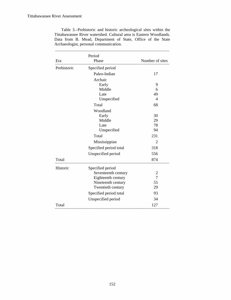
Table 3.–Prehistoric and historic archeological sites within the Tittabawassee River watershed. Cultural area is Eastern Woodlands. Data from B. Mead, Department of State, Office of the State Archaeologist, personal communication.
Era Period
Phase Number of sites
Prehistoric Specified period Paleo-Indian 17 Archaic Early 9 Middle 6
Late 49 Unspecified 4 Total 68 Woodland Early 30 Middle 29 Late 78 Unspecified 94 Total 231 Mississippian 2 Specified period total 318 Unspecified period 556 Total 874
Historic Specified period Seventeenth century 2 Eighteenth century 7 Nineteenth century 55 Twentieth century 29 Specified period total 93 Unspecified period 34 Total 127

Tittabawassee River Assessment
153
Table 4.–Bedrock layers, period of their formation, and composition within the Tittabawassee River watershed.
Bedrock layer Period of formation Area mi2 Percent of watershed
Red Beds Late Jurassic 1,025.68 41.51
Grand River Formation Late Pennsylvanian 1.50 0.06
Saginaw Formation Early Pennsylvanian 1,379.76 55.83
Bayport Limestone Late Mississippian 4.36 0.18
Michigan Formation Late Mississippian 58.04 2.35
Marshall Formation Early Mississippian 1.67 0.07
Coldwater Shale Early Mississippian 0.18 0.01
Table 5.–Percent of the Tittabawassee River watershed covered by various surficial materials and permeability rates.
Material Percent of watershed
Permeability ([ft/day]*1,000)
High permeability Ice-contact outwash sand and gravel 4.7 328.08 End moraines of coarse-texture till 38.0 98.43 Dune sand 3.0 65.62 Glacial outwash sand and gravel and postglacial alluvium 14.5 65.62
Medium permeability Lacustrine sand and gravel 39.8 32.81
Table 6.–Annual precipitation by weather station within the Tittabawassee River watershed, 1951-80.
Precipitation (inches) Form Midland Gladwin Alma Mt. Pleasant
Rain 25.8 27.5 26.3 27.4
Snow 37.7 51.6 41.8 36.3
Total 28.7 31.5 29.6 30.2

Tittabawassee R
iver Assessm
ent
154
Table 7.–United States Geological Survey gauging stations within the Tittabawassee River watershed. Station numbers are referenced in Figure 6. Included in this table are period of record for each station, mean discharge, watershed area, and mean yield.
Segment name, Latitude USGS Period Mean discharge Watershed Mean yieldmap number–river Location Longitude station no. of record (ft3/s) area (mi2) (ft3/s mi2)
Middle 1–Tobacco Beaverton 43.879500° 04152500 1948–82 373.8 487 0.77
-84.473833° 2–South Branch Tobacco Beaverton 43.867000° 04152238 1987–03 74.2 160 0.46
-84.545333 Mouth
3–Tittabawassee Midland 43.595333° 04156000 1936–03 1,702.1 2,400 0.71 -84.235500°
4–Tittabawassee Freeland 43.522000° 04156500 1930–36 1,265.6 2,530 0.50 -84.125333° 5–Salt North Bradley 43.702833° 04153500 1934–71 75.7 138 0.55
-84.470500° 6–Chippewa Mt. Pleasant 43.625500° 04154000 1930–03 322.9 416 0.78
-84.707833° 7–Chippewa Midland 43.594500° 04154500 1947–72 426.5 597 0.71
-84.369500° 8–Pine Alma 43.379500° 04155000 1930–2003 228.2 288 0.79
-84.655500° 9–Pine Midland 43.564500° 04155500 1934–38 316.0 390 0.81
-84.369167° 1948–97 2000–03
Tittabawassee River Assessment
155
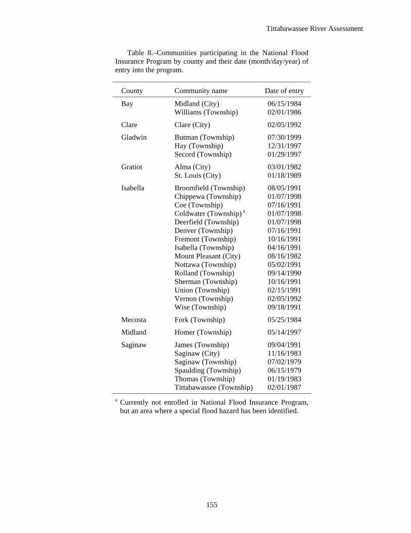
Table 8.–Communities participating in the National Flood Insurance Program by county and their date (month/day/year) of entry into the program.
County Community name Date of entry
Bay Midland (City) 06/15/1984 Williams (Township) 02/01/1986
Clare Clare (City) 02/05/1992
Gladwin Butman (Township) 07/30/1999 Hay (Township) 12/31/1997 Secord (Township) 01/29/1997
Gratiot Alma (City) 03/01/1982 St. Louis (City) 01/18/1989
Isabella Broomfield (Township) 08/05/1991 Chippewa (Township) 01/07/1998 Coe (Township) 07/16/1991 Coldwater (Township) a 01/07/1998 Deerfield (Township) 01/07/1998 Denver (Township) 07/16/1991 Fremont (Township) 10/16/1991 Isabella (Township) 04/16/1991 Mount Pleasant (City) 08/16/1982 Nottawa (Township) 05/02/1991 Rolland (Township) 09/14/1990 Sherman (Township) 10/16/1991 Union (Township) 02/15/1991 Vernon (Township) 02/05/1992 Wise (Township) 09/18/1991
Mecosta Fork (Township) 05/25/1984
Midland Homer (Township) 05/14/1997
Saginaw James (Township) 09/04/1991 Saginaw (City) 11/16/1983 Saginaw (Township) 07/02/1979 Spaulding (Township) 06/15/1979 Thomas (Township) 01/19/1983 Tittabawassee (Township) 02/01/1987
a Currently not enrolled in National Flood Insurance Program, but an area where a special flood hazard has been identified.

Tittabawassee River Assessment
156
Table 9.–Year 2001 water withdrawal from the Tittabawassee River watershed, select watersheds, and statewide. Units are in gallons/day/mi2 (MDEQ 2005b).
Water source Watershed Great Lakes Surface water Groundwater Total
Au Sable 0 322 1,851 2,173
Cheboygan 0 369 2,764 3,133
Clinton 8,618 4,177 26,505 39,300
Flint 0 1,902 5,840 7,742
Huron 697 29,154 20,089 49,940
Kalamazoo 0 8,242 43,710 51,952
Manistique 0 4,130 53 4,184
Muskegon 109,623 3,104 9,572 122,298
Thunder 93,186 520 1,599 95,306
Tittabawassee 28 2,326 3,798 6,152
Statewide 164,473 7,545 8,727 180,745
Table 10.–Irrigated agriculture 1997, estimated agricultural water withdrawal 2001, and total water withdrawal within the Tittabawassee River watershed (MDEQ 2005c).
1997 2001 No. farms Irrigated (gallons/day/mi2) Land use ≥14 acres acres Great Lakes Surface water Groundwater Total
Agriculture 31 4,528 0 190 752 942
Nonagriculture 28 2,136 3,046 5,210
Total 28 2,326 3,798 6,152

157
Tittabawassee R
iver Assessm
ent
Table 11.–Presettlement land cover (circa 1800) by percentage of area for the Tittabawassee River watershed and for catchments of the main stem segments and their major tributaries. Catchment summaries for a segment represent the local landscape that contributes water to the segment and do not represent the cumulative upstream landscape.
Cover type Watershed Headwaters Middle Tobacco Mouth Salt Chippewa Pine
Aspen–birch forest 0.9 0.8 0.6 0.0 1.9 3.4 0.7 0.5
Beech–sugar maple forest 19.1 0.0 0.0 0.2 20.9 29.7 25.6 46.9
Beech–sugar maple–hemlock forest 25.4 21.6 20.0 48.9 9.2 24.9 33.9 1.5
Black ash swamp 1.0 0.6 1.1 2.0 0.8 1.3 0.8 0.4
Cedar swamp 6.0 19.5 14.1 9.1 0.0 4.4 2.0 0.9
Hemlock–white pine forest 20.8 30.3 38.3 12.1 43.8 24.8 15.4 6.1
Jack pine–red pine forest 0.3 1.2 1.5 0.1 0.0 0.0 0.0 0.0
Lake/river 0.8 1.1 0.5 0.8 0.6 0.1 1.5 0.5
Mixed conifer swamp 8.6 4.1 16.0 9.4 11.5 6.0 7.8 5.0
Mixed hardwood swamp 4.4 0.7 2.9 1.6 10.1 4.3 2.9 9.1
Muskeg/bog <0.1 0.0 0.0 0.0 0.0 0.0 <0.1 <0.1
Oak/pine barrens 0.2 0.0 0.0 1.1 0.0 0.0 0.0 0.0
Oak–hickory forest <0.1 0.0 0.0 0.0 0.0 0.0 0.0 0.2
Pine barrens 0.5 6.4 0.0 0.2 0.0 0.0 0.0 0.0
Shrub swamp/emergent marsh 0.8 0.6 2.1 0.7 0.7 0.2 0.9 0.3
White pine–mixed hardwood forest 5.9 0.0 0.0 0.0 0.0 0.0 7.7 23.9
White pine–red pine forest 4.0 13.2 3.1 11.9 0.4 0.9 0.8 0.0
White pine–white oak forest 1.2 0.0 0.0 1.9 0.0 0.0 0.0 4.8

Tittabawassee River Assessment
158
Table 12.–Current land use by percentage of area for the Tittabawassee River watershed and for catchments of the main stem segments and their major tributaries. Catchment summaries for a segment represent the local landscape that contributes water to the segment and do not represent the cumulative upstream landscape.
Land use Watershed Headwaters Middle Tobacco Mouth Salt Chippewa Pine
Agriculture 44.8 12.0 21.2 36.2 38.7 61.0 54.4 67.8
Commercial 0.8 0.5 0.1 0.5 3.4 0.5 0.6 0.4
Developed 1.2 0.0 0.2 0.6 6.5 0.3 0.8 1.0
Grassland 1.3 4.5 3.0 2.4 0.2 0.2 0.1 0.1
Open water 1.7 2.3 3.3 1.5 1.6 0.1 2.0 0.6
Upland 34.8 53.7 37.9 47.7 30.8 24.1 32.3 21.4
Wetland 15.4 26.9 34.3 11.0 18.8 13.8 9.8 8.6
Table 13.–Agricultural use by acres for the Tittabawassee River watershed and for catchments of the main stem segments and their major tributaries. Catchment summaries for a segment represent the local landscape that contributes water to the segment and do not represent the cumulative upstream landscape.
Agricultural use Watershed Headwaters Middle Tobacco Mouth Salt Chippewa Pine
Grassland/Herbaceous 18,829 5,400 5,914 7,515
Pasture/Hay 125,148 7,304 12,438 26,687 5,777 9,440 34,513 28,990
Row crops 583,282 6,728 29,135 85,408 56,228 76,866 175,670 153,246
Total acres 727,258 19,432 47,487 119,611 62,004 86,303 210,183 182,236
Table 14.–Number of oil and natural gas wells and wells per mi2 for the Tittabawassee River watershed and for catchments of the main stem segments and their major tributaries.
Number of oil & gas wells Watershed Upper Middle Tobacco Mouth Salt Chippewa Pine
Wells 398 2 45 34 38 117 96 66
Wells/mi2 0.16 0.01 0.15 0.07 0.15 0.53 0.16 0.16

Tittabawassee River Assessment
159
Table 15.–Classification of gradient and the channel characteristics associated with each. Data from G. Whelan, MDNR, Fisheries Division, unpublished data.
Gradient class Value (ft/mi) Channel characteristics
Low 0.0–2.9 Mostly run habitat with low hydraulic diversity Fair 3.0–4.9 Some riffles with modest hydraulic diversity Good 5.0–9.9 Riffle-pool sequences with good hydraulic diversity Excellent 10.0–69.9 Established, regular riffle-pool sequences with excellent
hydraulic diversity Fair 70.0–149.9 Chute and pool habitats with only fair hydraulic diversity Poor >150 Falls and rapids with poor hydraulic diversity
Table 16.–Percent of river miles in each gradient class for the Tittabawassee River watershed. Total miles of river for each segment and tributary in parentheses.
Percentage Gradient Upper Middle Tobacco S. Br. Tobacco Mouth Salt Chippewa Pine (ft/mi) (20) (36) (34) (38) (35) (18) (89) (94)
0.0–2.9 5.0 61.1 34.2 100.0 66.7 31.5 47.9
3.0–4.9 20.0 38.9 31.3 43.8 28.1
5.0–9.9 20.0 15.6 39.5 33.3 24.7 18.8
10.0–69.9 45.0 53.1 26.3 5.2
70.0–149.9 10.0
>150

Tittabawassee R
iver Assessm
ent
160
Table 17.–United States Geological Survey gauging stations within the Tittabawassee River watershed. Station numbers are referenced in Figure 6. Included in this table are record period for each station, measured bank full widths, expected lower 95% estimated width, expected mean width, and expected upper 95% upper width. Measured bank-full widths outside of the lower and upper 95% widths are noted with “*”.
Segment name, USGS Period Width (ft) map number–river Location station no. of record Measured Lower 95% Expected mean Upper 95%
Middle 2–Tobacco Beaverton 04152500 1948–82 92.2 75.2 105.6 148.5 3–South Branch Tobacco Beaverton 04152238 1987–03 55.1 35.1 47.2 63.5
Mouth 9–Tittabawassee Midland 04156000 1936–03 216.8 153.6 224.9 329.3 4–Salt North Bradley 04153500 1934–71 60.8 35.4 47.7 64.2 5–Chippewa Mt. Pleasant 04154000 1930–03 84.8 70.1 98.2 137.5 6–Chippewa Midland 04154500 1947–72 205.5* 80.0 112.8 159.1 7–Pine Alma 04155000 1930–03 80.3 59.6 82.6 114.6 8–Pine Midland 04155500 1934–38 183.0* 69.4 97.2 135.9
1948–97 2000–03

Tittabawassee R
iver Assessm
ent
161
Table 18.–Dams and water control structures in the Tittabawassee River watershed. Data from Department of Environmental Quality, Land and Water Management Division, Dams Safety Unit. Hazard ranking: low, significant, high. High hazard = loss of life would occur; significant hazard = large amounts of property damage would occur. Blank indicates no data available. Dam no. corresponds to Figures 46-48. Dam type “other” includes stop logs and rock rip-rap. Sig = significant; hydro = hydroelectric producing.
Segment Dam Tributary Surface no. Dam name River Latitude Longitude Built Owner Type Height Acres acres Purpose Hazard
Headwaters Main Stem
1 Baker Wheeler Drain 44.082886° -84.372730° 1962 Private Earth 19 7 40 Recreation Low 2 Benmark West Branch Tittabawassee 44.205928° -84.428034° 1945 Private Gravity 12 1 10 Recreation Low 3 Benmark West Branch Tittabawassee 44.213272° -84.428756° 1945 Private Gravity 6 3 10 Recreation Low 4 Benmark West Branch Tittabawassee 44.203607° -84.427422° 1945 Private Other 5 2 4 Recreation Low 5 Benmark West Branch Tittabawassee 44.214564° -84.434322° 1945 Private Gravity 10 4 16 Recreation Low 6 Benmark West Branch Tittabawassee 44.212195° -84.429431° 1945 Private Other 9 4 14 Recreation Low 7 Benmark West Branch Tittabawassee 44.208451° -84.430189° 1945 Private Gravity 12 2 30 Recreation Low 8 Benmark West Branch Tittabawassee 44.197318° -84.416622° 1945 Private Gravity 6 2 5 Recreation Low 9 Benmark West Branch Tittabawassee 44.203287° -84.425817° 1940 Private Earth 7 1 0 Recreation Low
10 Blackhurst West Branch Tittabawassee 44.225007° -84.418029° 1967 Private Earth 9 4 18 Recreation Low 11 Bowsher West Branch tributary 44.170518° -84.308542° Private 3 1 0 Low 12 Bowsher West Branch tributary 44.169488° -84.308761° Private 3 1 0 Low 13 Bowsher West Branch tributary 44.170843° -84.307023° Private 3 1 0 Low 14 Bunting Cooks Creek 44.238445° -84.229488° 1970 Private Earth 7 1 0 Water supply Low 15 Cahoon Mansfield tributary 44.207300° -84.313093° Private Earth 8 2 0 Recreation Low 16 Cushoff West Branch tributary 44.184044° -84.448461° 1966 Private Other 7 2 0 Recreation Low 17 Dunham West Branch tributary 44.206356° -84.406969° 1961 Private Earth 5 19 100 Recreation Low 18 Ed Klemac West Branch tributary 44.133348° -84.374968° 1961 Private Earth 11 1 0 Other Low 19 Elk Lake Elk Lake Creek 44.151269° -84.360072° Private 1 65 0 Low 20 Good News Wheeler Drain 44.079947° -84.369127° 1964 Private Earth 12 2 8 Recreation Low 21 Hill East Branch tributary 44.137794° -84.229657° Private 5 Low 22 Hoffman Lake Four 44.151360° -84.427749° 1964 Private Earth 19 3 29 Farm Pond Low 23 Horgewski East Branch tributary 44.222808° -84.261811° 1949 Private Gravity 3 1 2 Recreation Low 24 Huston Lake Four Creek 44.148518° -84.415525° Private 19 3 0 Low 25 Morris Lake Parren Creek tributary 44.238745° -84.339724° 1965 Private Earth 21 15 181 Recreation Low 26 Rau Lake Rau Creek 44.223948° -84.263605° 1970 Private Earth 0 0 0 Recreation 27 Sanislow West Branch tributary 44.182757° -84.414830° 1960 Private Earth 34 4 Recreation Low

Tittabawassee R
iver Assessm
ent
162
Table 18.–Continued.
Segment Dam Tributary Surface no. Dam name River Latitude Longitude Built Owner Type Height Acres acres Purpose Hazard
28 Soloskey West Branch Tittabawassee 44.166684° -84.386685° 1951 Private Gravity 6 2 0 Low 29 Stillwagon Mansfield tributary 44.191685° -84.323334° Private Earth 6 1 0 Recreation Low 30 Timmeck West Branch tributary 44.166301° -84.409405° 1969 Private Gravity 15 2 0 Recreation Low 31 Toutant Elk Lake Creek 44.108335° -84.353410° Private 3 3 0 Low 32 Winter Perry’s Creek 44.235010° -84.314208° Private 3 1 0 Low 33 Winter Perry’s Creek 44.235474° -84.313204° Private 3 1 0 Low 34 West Branch Tittabawassee tributary 44.168877° -84.386145°
Middle Main Stem
35 Edenville Tittabawassee 43.816298° -84.384026° 1924 Private Earth, gravity 54 2250 66200 Hydro High
36 Frayer Sugar River tributary 44.071162° -84.397029° 1972 Private Earth 26 4 90 Farm Pond Low 37 Heil Black Creek 43.971529° -84.323234° 1970 Private Earth 23 10 140 Recreation Low 38 Lake Lancer Sugar River 44.106394° -84.435254° 1976 Private Earth 36 977 17500 Recreation High 39 Lake Lancelot Sugar River tributary 44.110302° -84.465114° 1976 Private Earth 17 250 2100 Recreation Low 40 Lake Lochbrae Long Lake Creek 44.103548° -84.487378° 1968 Private Earth 14 82 700 Recreation Sig 41 Sugar River tributary 44.163425° -84.486906° Private Earth 7 1 30 Low 42 Molasses Molasses 44.085164° -84.205473° 1949 State Earth 5 83 276 Recreation Low 43 Molasses Little Molasses 43.948641° -84.186840° 1955 State Earth 12 590 4100 Recreation Low 44 Molasses Molasses 44.074126° -84.224654° 1959 State Earth 12 228 2000 Recreation Low 45 Molasses Molasses tributary 44.005288° -84.211966° 1962 State Earth 9 195 1240 Other Low 46 Morey Sugar River 44.143719° -84.500011° 1912 Private Earth 6 2 Recreation Low 47 Priddy Lake Sugar River tributary 44.196946° -84.495490° 1968 Private Earth 16 9 80 Recreation Sig 48 Russell Sugar River tributary 44.136948° -84.483488° 1950 Private Earth 17 4 50 Recreation Low 49 Sanford Tittabawassee 43.676807° -84.380246° 1925 Private Earth,
gravity 36 1528 34500 Hydro High 50 Secord Tittabawassee 44.041171° -84.341817° 1925 Private Earth,
gravity 57 894 51000 Hydro High 51 Smallwood Tittabawassee 43.960012° -84.335796° 1925 Private Earth,
gravity 36 402 9000 Hydro High Tobacco River
52 Arnold Lake Cranberry Creek 44.065277° -84.746942° 1966 Private Earth 4 118 190 Recreation Low 53 Beaverton Tobacco 43.883272° -84.483444° 1919 Local gov Gravity 30 270 2390 Hydro High
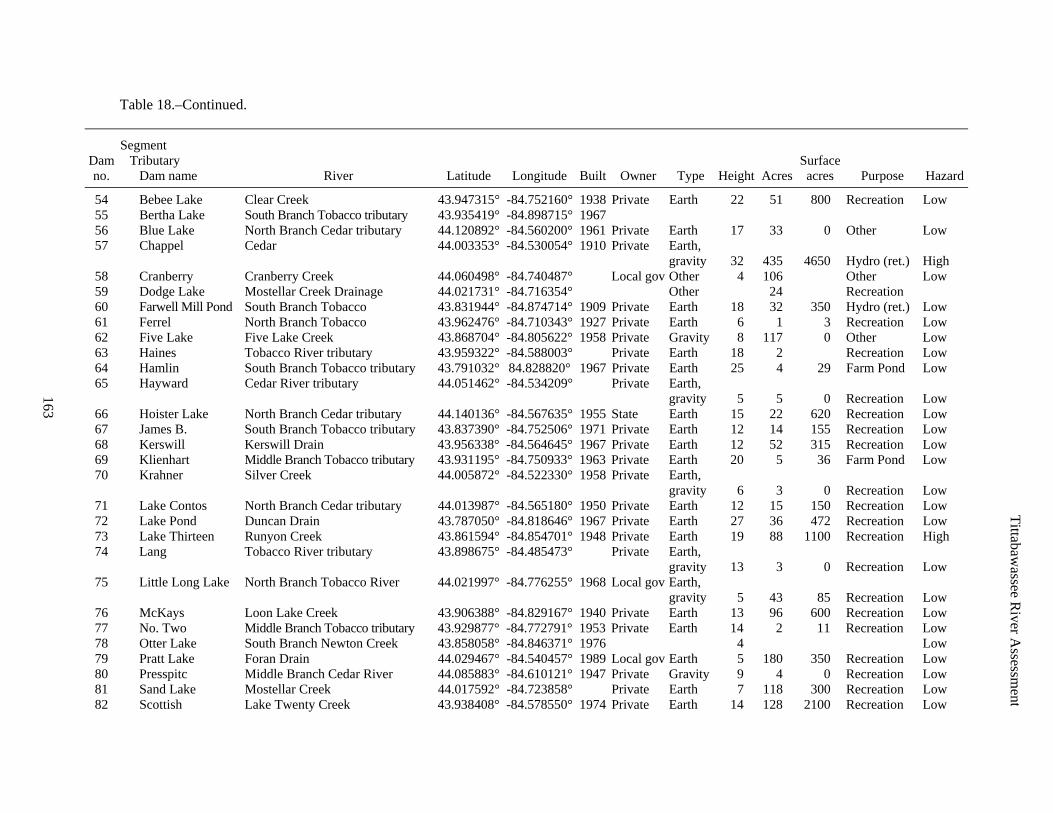
Tittabawassee R
iver Assessm
ent
163
Table 18.–Continued.
Segment Dam Tributary Surface no. Dam name River Latitude Longitude Built Owner Type Height Acres acres Purpose Hazard
54 Bebee Lake Clear Creek 43.947315° -84.752160° 1938 Private Earth 22 51 800 Recreation Low 55 Bertha Lake South Branch Tobacco tributary 43.935419° -84.898715° 1967 56 Blue Lake North Branch Cedar tributary 44.120892° -84.560200° 1961 Private Earth 17 33 0 Other Low 57 Chappel Cedar 44.003353° -84.530054° 1910 Private Earth,
gravity 32 435 4650 Hydro (ret.) High 58 Cranberry Cranberry Creek 44.060498° -84.740487° Local gov Other 4 106 Other Low 59 Dodge Lake Mostellar Creek Drainage 44.021731° -84.716354° Other 24 Recreation 60 Farwell Mill Pond South Branch Tobacco 43.831944° -84.874714° 1909 Private Earth 18 32 350 Hydro (ret.) Low 61 Ferrel North Branch Tobacco 43.962476° -84.710343° 1927 Private Earth 6 1 3 Recreation Low 62 Five Lake Five Lake Creek 43.868704° -84.805622° 1958 Private Gravity 8 117 0 Other Low 63 Haines Tobacco River tributary 43.959322° -84.588003° Private Earth 18 2 Recreation Low 64 Hamlin South Branch Tobacco tributary 43.791032° 84.828820° 1967 Private Earth 25 4 29 Farm Pond Low 65 Hayward Cedar River tributary 44.051462° -84.534209° Private Earth,
gravity 5 5 0 Recreation Low 66 Hoister Lake North Branch Cedar tributary 44.140136° -84.567635° 1955 State Earth 15 22 620 Recreation Low 67 James B. South Branch Tobacco tributary 43.837390° -84.752506° 1971 Private Earth 12 14 155 Recreation Low 68 Kerswill Kerswill Drain 43.956338° -84.564645° 1967 Private Earth 12 52 315 Recreation Low 69 Klienhart Middle Branch Tobacco tributary 43.931195° -84.750933° 1963 Private Earth 20 5 36 Farm Pond Low 70 Krahner Silver Creek 44.005872° -84.522330° 1958 Private Earth,
gravity 6 3 0 Recreation Low 71 Lake Contos North Branch Cedar tributary 44.013987° -84.565180° 1950 Private Earth 12 15 150 Recreation Low 72 Lake Pond Duncan Drain 43.787050° -84.818646° 1967 Private Earth 27 36 472 Recreation Low 73 Lake Thirteen Runyon Creek 43.861594° -84.854701° 1948 Private Earth 19 88 1100 Recreation High 74 Lang Tobacco River tributary 43.898675° -84.485473° Private Earth,
gravity 13 3 0 Recreation Low 75 Little Long Lake North Branch Tobacco River 44.021997° -84.776255° 1968 Local gov Earth,
gravity 5 43 85 Recreation Low 76 McKays Loon Lake Creek 43.906388° -84.829167° 1940 Private Earth 13 96 600 Recreation Low 77 No. Two Middle Branch Tobacco tributary 43.929877° -84.772791° 1953 Private Earth 14 2 11 Recreation Low 78 Otter Lake South Branch Newton Creek 43.858058° -84.846371° 1976 4 Low 79 Pratt Lake Foran Drain 44.029467° -84.540457° 1989 Local gov Earth 5 180 350 Recreation Low 80 Presspitc Middle Branch Cedar River 44.085883° -84.610121° 1947 Private Gravity 9 4 0 Recreation Low 81 Sand Lake Mostellar Creek 44.017592° -84.723858° Private Earth 7 118 300 Recreation Low 82 Scottish Lake Twenty Creek 43.938408° -84.578550° 1974 Private Earth 14 128 2100 Recreation Low

Tittabawassee R
iver Assessm
ent
164
Table 18.–Continued.
Segment Dam Tributary Surface no. Dam name River Latitude Longitude Built Owner Type Height Acres acres Purpose Hazard
83 Shamrock South Branch Tobacco 43.830474° -84.753006° 1962 Local gov Earth 20 120 882 Recreation High 84 Sikkema Elm Creek 43.860165° -84.916564° 1963 Private Earth 10 4 0 Other Low 85 Spring Valley Newton Creek 43.892007° -84.859915° 1956 Private Earth 6 4 0 Other Low 86 Springwood North Branch Cedar tributary 44.007158° -84.688047° 1959 Private Earth 18 70 230 Recreation Low 87 Springwood North Branch Cedar tributary 44.007776° -84.680241° 1959 Private Earth 11 32 320 Recreation Low 88 Surrey Lake Elm Creek 43.850045° -84.910654° 1965 Private Earth 16 234 1800 Recreation High 89 Sutherland Lake North Branch Tobacco 44.019772° -84.774311° 1968 Private Earth 9 78 230 Recreation Low 90 Trout Lake North Branch Cedar tributary 44.135562° -84.562775° 1961 State Earth 19 25 240 Recreation Low 91 Valdaloch Overton Creek 43.874386° -84.920109° 1963 Private Earth 14 10 0 Other Low 92 Walter W. Middle Branch Tobacco tributary 43.904077° -84.738873° Private Earth 5 Other Low 93 Warner Cranberry Creek 44.047212° -84.707772° 1966 Private Earth 9 9 0 Recreation Low
Mouth 94 Cole Tittabawassee tributary 43.535175° -84.134103° 1949 Private Earth 16 3 15 Recreation Low 95 Dow Tittabawassee 43.599994° -84.238957° 1939 Private Gravity 7 0 Other Low 96 Lincoln’s Tittabawassee tributary 43.543183° -84.135329° 1951 Private Earth 7 11 0 Recreation Low
Salt River 97 Coleman B. Bluff Creek tributary 43.749096° -84.546788° State Low 98 Gregor Bluff Creek tributary 43.712976° -84.478252° Private Earth 6 1 0 Low 99 Marcus Bluff Creek tributary 43.707920° -84.468949° 1975 Private Earth 20 3 0 Recreation Low
Chippewa River 100 Barryton West Branch Chippewa 43.746479° -85.140520° 1920 Local gov Earth,
gravity 15 46 260 Hydro (ret.) Sig 101 Big Cranberry North Branch Chippewa 43.879550° -85.048447° 1961 Private Earth 6 293 Other Low 102 Birch Lake Long Lake Creek tributary 43.772556° -85.291243° 1985 Private Earth 11 Recreation Low 103 Chippewa Chippewa Creek 43.743591° -85.302234° Private 3 770 0 Low 104 Crooked Lake North Branch Chippewa tributary 43.856404° -85.020257° 1976 Low 105 Deerfield Chippewa River tributary 43.591099° -84.899263° 1960 State Earth 14 3 11 Other Low 106 Dragonfly West Branch Chippewa 43.593198° -84.284958° 1992 Private Earth 6 17 Other Low 107 Eight Point Eight Point Creek 43.831388° -85.072008° 1966 Private Gravity 4 388 615 Recreation Low 108 Forbes Delaney Creek 43.780893° -85.047783° Private Earth,
gravity 2 3 0 Recreation Low 109 Georgia J. Tanner Creek 43.716082° -85.108542° 1972 Private Earth 15 45 348 Recreation Low 110 Gray Lake North Branch Chippewa tributary 43.832313° -85.021895° Other 61 Recreation Low

Tittabawassee R
iver Assessm
ent
165
Table 18.–Continued.
Segment Dam Tributary Surface no. Dam name River Latitude Longitude Built Owner Type Height Acres acres Purpose Hazard
111 Grey's Walker Creek tributary 43.730217° -85.020220° 1959 Private Earth, gravity 5 1 8 Irrigation Low
112 Harris (removed) Chippewa 43.600887° 84.784778° 1870 Private Earth 16 2 150 Recreation Low 113 Heron West Branch Chippewa 43.595793° -84.284353° 1992 Private Earth 8 10 Other Low 114 Lake Camelot Black Creek 43.583594° -84.609733° 1971 Private Earth 19 85 855 Irrigation Low 115 Lake Isabella Chippewa 43.653379° -84.992598° 1967 Private Earth 45 730 13500 Recreation High 116 Long Lake Long Lake Creek tributary 43.775826° -85.295036° 1993 Local gov Other 6 75 Other Low 117 Maloy Lake North Branch Chippewa tributary 43.861566° -85.157209° 1962 Private Earth 5 40 180 Recreation Low 118 Maple Lake Long Lake Creek tributary 43.771307° -85.288793° 1985 Private Earth 11 4 Recreation Low 119 Mission Creek Mission Creek 43.621645° -84.792591° 1950 Private Earth 12 0 95 Recreation Low 120 Muskrat West Branch Chippewa 43.593514° -84.289127° 1992 Private Earth 6 10 Other Low 121 Peas Lake Johnson Creek 43.555666° -84.846607° 1961 Private Earth 18 10 165 Recreation Low 122 Phillips Bamber Creek tributary 43.723629° -85.136969° Private Earth 5 4 0 Low 123 Pretty Lake West Branch Chippewa tributary 43.698321° -85.231744° 1992 Local gov Other 6 116 Recreation Low 124 Siebecker Rattail Creek 43.808976° -85.195823° 1978 Private Earth 21 28 315 Recreation Low 125 Stevenson North Branch Chippewa tributary 43.757368° -84.826924° 1975 Private Earth,
gravity 5 113 340 Recreation Low 126 Thompson North Branch Chippewa 43.760225° -84.864314° Private Earth,
gravity 13 22 160 Recreation Low 127 Walker Creek Walker Creek 43.717681° -84.997996° 1965 Private Earth 17 41 850 Recreation Low 128 Walker Creek Walker Creek 43.724872° -85.000228° 1968 Private Earth 18 42 900 Recreation Sig 129 Weidman Mill Coldwater 43.688715° -84.964217° 1900 Private Earth 12 65 300 Recreation Sig 130 Wiedman Pond Walker Creek 43.693673° -84.971438° 1968 Private Earth 14 50 420 Recreation Sig 131 Winchester West Branch Chippewa 43.718365° -85.182989° 1954 State Earth 13 1420 7500 Recreation Sig
Pine River 132 Archer South Branch Pine tributary 43.410060° -84.992325° Private 11 2 0 Low 133 Babcocks South Branch Pine tributary 43.518238° -85.069934° 1973 Private Earth 18 9 66 Recreation Low 134 Blanchard North Branch Pine tributary 43.523086° -85.072599° 1978 Private Earth 12 13 300 Recreation Low 135 Fitzgeral Pony Creek 43.540912° -84.994606° 1965 Private Earth,
gravity 5 3 0 Recreation Low 136 Johnson Pond Skunk Creek tributary 43.477118° -85.037000° Private 6 1 0 Low 137 Mason Decker Creek tributary 43.522415° -85.123100° 1977 Private Earth 14 2 12 Recreation Low 138 Millbrook Pine Creek 43.556086° -85.119337° 1915 Private Other 7 1 25 Low

Tittabawassee R
iver Assessm
ent
166
Table 18.–Continued.
Segment Dam Tributary Surface no. Dam name River Latitude Longitude Built Owner Type Height Acres acres Purpose Hazard
139 Peterson Skunk Creek tributary 43.478762° -85.034651° 1948 Private Earth 12 10 0 Irrigation Low 140 Schafer Thatcher Creek 43.533550° -84.862915° 1969 Private Earth 10 3 60 Recreation Low 141 St Louis Pine 43.412628° -84.607385° 1887 Local gov Gravity 21 71 1000 Hydro Sig 142 State Street Pine 43.375107° -84.662165° 1938 Local gov Gravity 18 140 1500 Water supply Sig 143 Stevens Lake Carpenter Creek tributary 43.313097° -84.887808° Private Gravity 4 7 0 Recreation Low

Tittabawassee River Assessment
167
Table 19.–Designated trout streams (as of 2006) in the Tittabawassee River watershed. Streams are designated upstream of the town, range, and section number unless specified otherwise. Data are from MDNR (2005).
Segment County
Stream Location
Headwaters Ogemaw
East Br. Tittabawassee River from T21N, R2E, S32 upstream Spring Creek (T21N, R2E, S32) Cooks Creek (T21N, R2E, S20) Rau Creek (T21N, R1E, S13) Brick Creek (T21N, R1E, S13) Middle Br. Tittabawssee tributaries. Mansfield Creek (T21N, R1E, S22) Parren Creek (T21N, R1E, S10) Perrys Creek (T21N, R1E, S10)
Gladwin, Roscommon W. Br. Tittabawassee and tributaries From T20N, R1W, S23 upstream and tributaries
Except: Lake Four Outlet (Gladwin County) Roscommon
Muma Creek (T21N, R1W, S35) W. Br. Tittabawassee River (T21N, R1W, S22)
Roscommon, Ogemaw Unnamed tributary (T21N, R1W, S24)
Middle Gladwin, Roscommon
Sugar Creek (T21N, R1W, S24) Gladwin
Sugar River and tributaries upstream from T20N, R1W, S19 Sugar River (T20N, R1W, S22 and 27)
Gladwin, Clare Cedar River T19N, R2W, S20 upstream N. Br. Tobacco and tributaries (T17N, R2W, S1) Middle Br. Tobacco (T17N, R2W, S11)
Clare Middle Br. Cedar and tributaries (T19N, R3W, S14) West Branch Cedar River (T19N, R3W, S15) Cranberry Creek (T19N, R3W, S15) Popple Creek Creek (T20N, R3W, S34) Mostellar Creek downstream (T18N, R4W, S1),
upstream (T19N, R4W, S25) Jose Creek (T18N, R4W, S12) Spike Horn Creek (T19N, R4W, S35) Unnamed tributary (T18N, R3W, S32) Clear Creek (T18N, R3W, S30) S. Br. Tobacco River T17N, R4W, S27)

Tittabawassee River Assessment
168
Table 19.–Continued.
Segment County
Stream Location
Clare–continued Sanford Creek (Tl7N, R4W, S13) Five Lakes Creek (T17N, R4W, S33) Loon Lake Creek (T17N, R4W, S6) Newton Creek (Tl7N, R4W, S30) Runyon Creek (T17N, R5W, S13) Overton Creek (T17N, R5W, S26) Elm Creek (T17N, R5W, S16) Two unnamed tributaries (T17N, R5W, S28)
Mouth Mecosta, Osceola
North Branch Chippewa River (T16N, R7W, S27) Butts Creek (Devil Creek) (T16N, R7W, S11) Benjamin Creek Creek (T16N, R7W, S2)
Mecosta Rattail Creek (T16N, R7W, S22) Brown Creek (T16N, R7W, S28) Roundybranch Creek (T16N, R8W, S35)
Isabella Jewell Creek (T13N, R6W, S18) Squaw Creek (T14N, R6W, S3) Indian Creek (T14N, R6W, S3) Jewell Creek S18) (T14N, R6W, S3) Johnson Creek (T14N, R4W, S30) Colley Creek (T16N, R6W, S34) Delaney Creek (T16N, R6W, S34) Walker Creek and tributaries above T16N, R6W, S35 Cedar Creek (T14N, R5W, S27) Sucker Creek (T16N, R5W, S18)
Gratiot, Montcalm, Isabella, Mecosta Pine River mainstream mainstream from Lumberjack Road (T12N, R4W, S18)
upstream to 10th Avenue (T14N, R7W, S26) Gratiot, Montcalm, Isabella
North Branch Pine River from confluence with mainstream of Pine to Coe Road (T13N, R5W, S34)
Isabella, Mecosta Skunk Creek (T13N, R6W, S25)
Mecosta Miller Creek (T14N, R7W, S36)
Isabella Pony Creek from confluence with Pine River upstream to
S2, T13N, R6W Decker Creek (T13N, R6W, S18)

Tittabawassee River Assessment
169
Table 20.–Monthly maximum river temperatures (°F) allowed in selected streams. These standards are applied to all permitted stream discharges and are given a 2–5 °F variance as shown in Table 8b. Data from Michigan Department of Environmental Quality, Water Bureau.
Month Stream type Jan Feb Mar Apr May June July Aug Sept Oct Nov Dec
Temperature (°F)
Coldwater 38 38 43 54 65 68 68 68 63 56 48 40 Warmwater 41 40 50 63 76 84 85 85 79 68 55 43
Table 21.–Dissolved oxygen (mg/l) and temperature (°F) standards for designated uses of the
Tittabawassee River and tributaries. Temperatures represent allowable degrees of increase from the monthly river maximum. Data from Michigan Department of Environmental Quality, Water Bureau.
Minimum dissolved Designated use oxygen (mg/l) Temperature (°F)
Warmwater fish 5.0 5 Coldwater fish
Designated trout 7.0 2 Designated migratory route 5.0 5

Tittabawassee River Assessment
170
Table 22.–Areas not attaining designated uses (303d listings as of 2004) in the Tittabawassee River by segment. u/s = upstream; d/s = downstream.
Segment and stream Category a Problem Location
Headwaters E. Br. Tittabawassee River 2 Sedimentation Herner Road crossing SW of
Greenwood Road Middle Branch
Tittabawassee River 2 Sedimentation Boensch Road crossing, W. of
Greenwood Road W. Br. Tittabawassee River 2 Sedimentation Fitzwater Road crossing, NE
of Sugar Rapids Middle
Black Creek 2 E. of Woodenshoe at M61 upstream Larabee Creek 2 At Weiman Road crossing,
W. of Highwood Sugar River 2 Suspended Solids At M30 upstream Little Sugar River 2 Sugar River confluence u/s to M18 Little Tobacco River 2 Habitat and bank erosion At drain crossing NW
of Wooden Shoe Molasses River 2 Habitat and bank erosion At M61 crossing, E of Wooden Shoe Tittabawassee River 2 Sedimentation Fitzwater Crossing,
NE of Sugar Rapids Sanford Lake 5 FCA-PCBs and fish tissue
mercury NW of Midland at Sanford
Little Cedar River 2 At Dale Road SE of Beaverton Middle Branch Cedar River 2 Confluence with Cedar River u/s N. Br. Cedar River 2 Confluence with Cedar River u/s W. Br. Cedar River 2 Cranberry Creek confluence u/s Budd Lake 3 Vicinity of Harrison Cranberry Lake 3 NE of Harrison N. Br. Tobacco River 2 Grout Road u/s to Clarwin Road Middle Branch Tobacco River 2 McCullough Road u/s to Hoover AvenueBlack Creek 3 Sanford Lake Confluence,
West River Road S. Br. Tobacco River 2 Grout Road u/s to Rodgers Road S. Br. Tobacco River 2 Grant Road u/s of Clare N. Br. Tobacco River 3 Erosion Ross Lake Confluence u/s Middle Branch Tobacco River 3 Ross Lake Confluence u/s Tobacco River Shock Road u/s to Ross Lake Outlet Cedar River 5 CSO and pathogens Vicinity of Gladwin (M61) u/s
to Howard Oil Field Road Mouth
Viscar Drain 2 TWP 17, 18 Black Creek 3 Sanford Lake Confluence,
West River Road Carrol Creek Dr. 2 Habitat At Meridian Rd, NW of Midland Sturgeon Creek 3 Habitat Tittabawassee confluence Tittabawassee River 5 Untreated sewage
discharge, pathogens 1 mile d/s of Dow Dam
Tittabawassee River 5 FCA-PCBs, TCDD (Dioxins), fish tissue-mercury, WQS exceedances for hg
Dow Dam to confluence with Saginaw River

Tittabawassee River Assessment
171
Table 22.–Continued.
Segment and stream Category a Problem Location
Bluff Creek 2 Habitat Poseyville Road crossing Salt River 2 Big Salt River at North Bradley
to Rosebush Road Cedar Creek 2 Chippewa River confluence u/s
to Millbrook Road Chippewa River 2 At S. Meridian Road crossing,
SW of Mt. Pleasant Chippewa River 2 At Meridian Road crossing, W. of
Midland, E. of Little Salt Creek Chippewa River 2 At Coldwater Road crossing,
SW of Weidman Chippewa River 2 M-20 u/s to Barryton (excluding
Lake Isabella) Chippewa River 2 Lincoln Road u/s of Mt. Pleasant,
Jerome Twp, Sec. 24 Chippewa River, N. Br. 2 Coleman Road crossing u/s
to Grass Lake outlet Coldwater River 2 Temperature At Baseline Road crossing,
S. of Weidman Hogg Creek 2 Hogg Creek is a tributary to N. Br.
Chippewa River in Deerfield Twp. Jewel Creek 2 Blanchard Millpod confluence u/s Little Salt Creek 2 From confluence with Chippewa
River W. of 8 Mile Road (T14N, R1W) u/s to Redstone Road
Hogg Creek 2 Hogg Creek is a tributary to N. Br. Chippewa River in Deerfield Twp.
N. Br. Chippewa River 2 Chippewa River at Barryton u/s Walker Creek Lake of the Hills inlet u/s
(Section 11 Sherman Twp). Chippewa River 3 At Mt. Pleasant Chippewa River, S. Br. 3 SW of Barryton. 35th Avenue u/s to
Winchester Dam (19th Avenue) Crooked Lake 3 Vicinity of Lake Station S. of
U.S. Rt. 10 West of Clare Martiny Lake 3 SW of Barryton. u/s of Winchester
Dam on the W. Br. Chippewa River Potter Creek 3 Poor macroinvertebrates Onion Creek confluence u/s Salt Creek 3 Ammonia WQS exceedance
(one grab sample) Chippewa River confluence u/s Coldwater River 4a Biological community
threatened Vernon Road Crossing u/s to Outlet
Lake (Littlefield Lake area). Pine River 2 Harrison Road, SW of Alma, u/s to
Pine Lake, S. of Remus Pony Creek 2 Pine River confluence u/s Halls Lake 3 3.5 miles SE of Remus. D/s of
Wheatland Twp. WWSL and Pony Creek
Pine River, S. Br. 3 E. of Blanchard. Pine River confluence u/s

Tittabawassee River Assessment
172
Table 22.–Continued.
Segment and stream Category a Problem Location
Pony Creek 3 Wheatland Twp., E. of Remus on M-20
Rock Lake 3 NW of Vestaburg. E. of Pine Grove; E. of Pine Grove Road and N. of M-46
Sugar Creek 3 Poor macroinvertebrates Pine River confluence u/s from the vicinity of Begole Road
Wolf Creek 3 Assess fish for mercury concentrations due to historical discharges of mercury
d/s of Hitachi Magnetics in Edmore. Pine River confluence u/s to Cedar
Pine River and St. Louis Impoundment 4b FCA-PBBs, DDT
a Water quality assessment and water quality attainment categories: 1 All designated uses met. 2 Some uses are met but there is insufficient data to determine if remaining uses are met. 3 Insufficient data to determine whether any uses are met. 4a WQS Nonattained (USEPA approved TMDL but unverified WQS restoration). 4b WQS Nonattained (Other corrective action used but unverified WQS restoration). 4c WQS Nonattained (Highly modified water body). 5 Water is impaired or threatened and a TMDL is needed.

Tittabawassee River Assessment
173
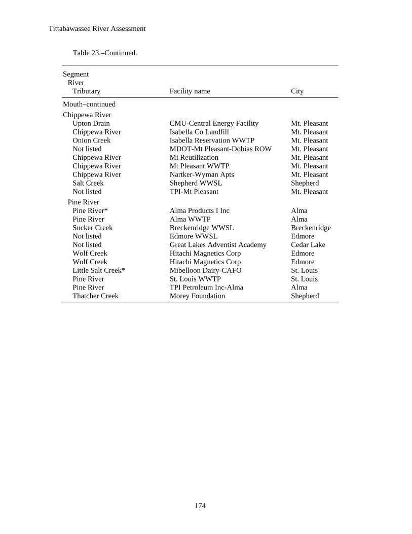
Table 23.–National Pollution Discharge Elimination System permits issued in the Tittabawassee River watershed by Michigan Department of Environmental Quality, Surface Water Quality Division. Acronyms: WWTP = wastewater treatment plant, WWSL = wastewater sewage lagoon, WW = wastewater, * = major discharges.
Segment River
Tributary Facility name City
Middle Main Stem
Unnamed Billings Township WWTP Beaverton Sugar River Butman Township WWTP Gladwin Unnamed Eggers Exc-Lakewood Estates Freeland Unnamed Stockholm Forest Vil MHP Bay City
Tobacco River Tobacco River Brown Machine-Beaverton Beaverton Tobacco River Brown Machine-Beaverton Beaverton South Branch Tobacco River Clare PRP Committee Clare South Branch Tobacco River Clare WWTP Clare Unnamed Clare-Water Filtration Plant Clare Not listed Farwell WWSL Farwell Cedar River Gladwin WWTP Gladwin Bailey Creek Packard Farms-CAFO Clare
Mouth Main Stem
Unnamed Bullock Creek High School WWSL Midland Tittabawassee River* Dow Chemical-Midland Midland Lingle Drain Dow Corning Corp-Midland Midland Lingle Drain Dow Corning Corp-Midland Midland Unnamed Fisher Cont Co-Pardel Pit Midland Unnamed Freeland MHP Freeland Tittabawassee River* Midland Cogeneration Venture Midland Tittabawassee River* Midland WWTP Midland Tittabawassee River Old Oak Trails Est MHP Sanford Sturgeon Creek Pats Gradall Stark Pit Hope Tittabawassee River* Saginaw Township WWTP Saginaw Tittabawassee River Saginaw Township-Center Road LF Saginaw Carrol Creek Drain Sterling Manor MHP Midland Tittabawassee River Tittabawassee Township WWTP Freeland Not listed James Township MS4-Saginaw Saginaw Not listed Saginaw Township MS4-Saginaw Saginaw Not listed Tittabawassee Township MS4-Saginaw Freeland Not listed Thomas Township MS4-Saginaw Saginaw
Salt River Jordon Creek Country Place Park MHP Mt. Pleasant Unnamed Rosebush WWSL Rosebush Bluff Creek Coleman WWSL Coleman Bluff Creek, Mud Creek Robinson Industries Inc Coleman Bluff Creek Huhtamaki Plastics Inc Coleman
Tittabawassee River Assessment
174
Table 23.–Continued.
Segment River
Tributary Facility name City
Mouth–continued Chippewa River
Upton Drain CMU-Central Energy Facility Mt. Pleasant Chippewa River Isabella Co Landfill Mt. Pleasant Onion Creek Isabella Reservation WWTP Mt. Pleasant Not listed MDOT-Mt Pleasant-Dobias ROW Mt. Pleasant Chippewa River Mi Reutilization Mt. Pleasant Chippewa River Mt Pleasant WWTP Mt. Pleasant Chippewa River Nartker-Wyman Apts Mt. Pleasant Salt Creek Shepherd WWSL Shepherd Not listed TPI-Mt Pleasant Mt. Pleasant
Pine River Pine River* Alma Products I Inc Alma Pine River Alma WWTP Alma Sucker Creek Breckenridge WWSL Breckenridge Not listed Edmore WWSL Edmore Not listed Great Lakes Adventist Academy Cedar Lake Wolf Creek Hitachi Magnetics Corp Edmore Wolf Creek Hitachi Magnetics Corp Edmore Little Salt Creek* Mibelloon Dairy-CAFO St. Louis Pine River St. Louis WWTP St. Louis Pine River TPI Petroleum Inc-Alma Alma Thatcher Creek Morey Foundation Shepherd
Tittabawassee River Assessment
175
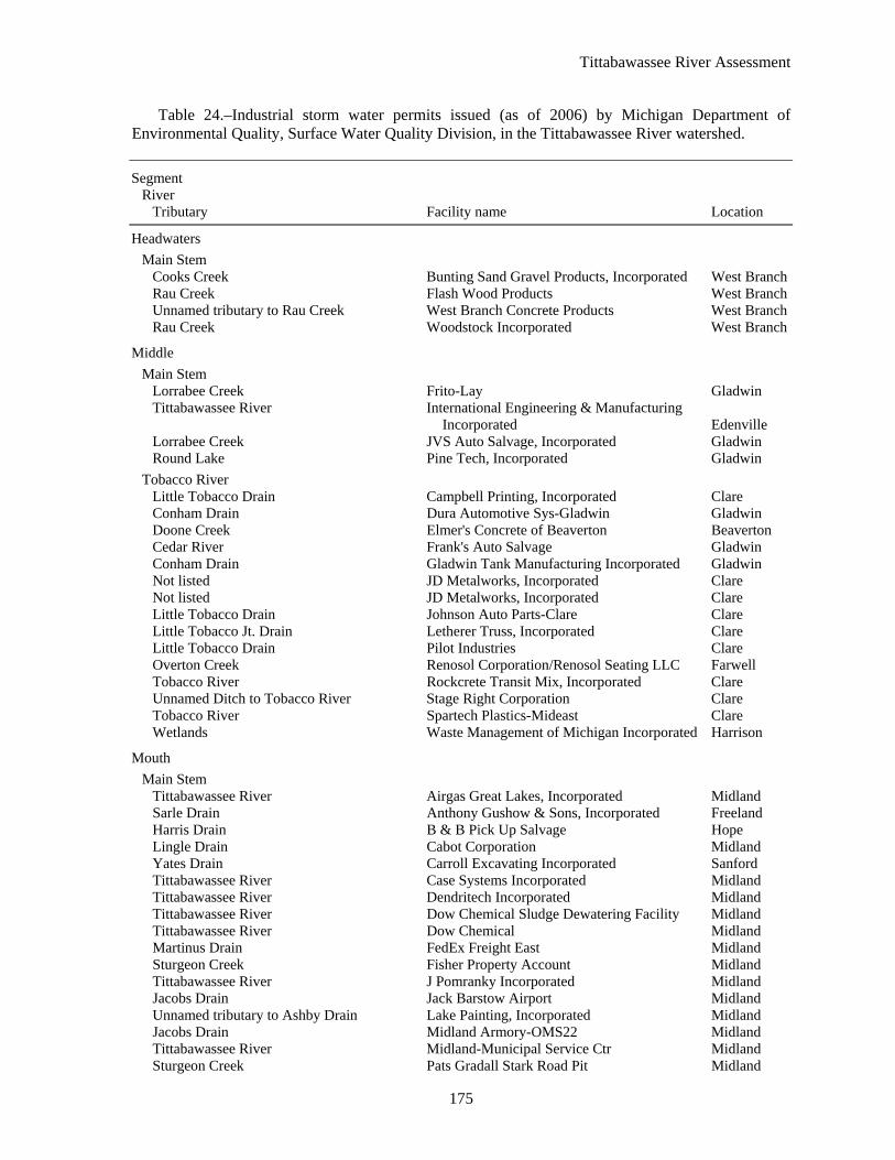
Table 24.–Industrial storm water permits issued (as of 2006) by Michigan Department of Environmental Quality, Surface Water Quality Division, in the Tittabawassee River watershed.
Segment River
Tributary Facility name Location
Headwaters Main Stem
Cooks Creek Bunting Sand Gravel Products, Incorporated West BranchRau Creek Flash Wood Products West BranchUnnamed tributary to Rau Creek West Branch Concrete Products West BranchRau Creek Woodstock Incorporated West Branch
Middle Main Stem
Lorrabee Creek Frito-Lay Gladwin Tittabawassee River International Engineering & Manufacturing
Incorporated Edenville Lorrabee Creek JVS Auto Salvage, Incorporated Gladwin Round Lake Pine Tech, Incorporated Gladwin
Tobacco River Little Tobacco Drain Campbell Printing, Incorporated Clare Conham Drain Dura Automotive Sys-Gladwin Gladwin Doone Creek Elmer's Concrete of Beaverton Beaverton Cedar River Frank's Auto Salvage Gladwin Conham Drain Gladwin Tank Manufacturing Incorporated Gladwin Not listed JD Metalworks, Incorporated Clare Not listed JD Metalworks, Incorporated Clare Little Tobacco Drain Johnson Auto Parts-Clare Clare Little Tobacco Jt. Drain Letherer Truss, Incorporated Clare Little Tobacco Drain Pilot Industries Clare Overton Creek Renosol Corporation/Renosol Seating LLC Farwell Tobacco River Rockcrete Transit Mix, Incorporated Clare Unnamed Ditch to Tobacco River Stage Right Corporation Clare Tobacco River Spartech Plastics-Mideast Clare Wetlands Waste Management of Michigan Incorporated Harrison
Mouth Main Stem
Tittabawassee River Airgas Great Lakes, Incorporated Midland Sarle Drain Anthony Gushow & Sons, Incorporated Freeland Harris Drain B & B Pick Up Salvage Hope Lingle Drain Cabot Corporation Midland Yates Drain Carroll Excavating Incorporated Sanford Tittabawassee River Case Systems Incorporated Midland Tittabawassee River Dendritech Incorporated Midland Tittabawassee River Dow Chemical Sludge Dewatering Facility Midland Tittabawassee River Dow Chemical Midland Martinus Drain FedEx Freight East Midland Sturgeon Creek Fisher Property Account Midland Tittabawassee River J Pomranky Incorporated Midland Jacobs Drain Jack Barstow Airport Midland Unnamed tributary to Ashby Drain Lake Painting, Incorporated Midland Jacobs Drain Midland Armory-OMS22 Midland Tittabawassee River Midland-Municipal Service Ctr Midland Sturgeon Creek Pats Gradall Stark Road Pit Midland

Tittabawassee River Assessment
176
Table 24.–Continued.
Segment River
Tributary Facility name Location
Mouth–continued Tittabawassee River Quebecor World Midland Midland Newell Drain Sova Auto Sales and Parts Midland Tittabawassee River Specialty Manufacturing, Incorporated Saginaw Jacobs Drain Three Rivers Construction Company Midland Lingle Drain Transport Service Company Midland Unnamed tributary to Tittabwawassee River Willsie Lumber Company Freeland
Salt River Howard Drain #11 C & M Rubber Technologies Incorporated Coleman Curtis Drain G & D Auto Sales Coleman Curtis Drain Homestead Tool & Machine, Incorporated Coleman Curtis Drain Homestead Tool & Machine, Incorporated Coleman Unnamed tributary of Howard Creek Mark-1 Flooring, Incorporated Coleman Bluff Creek Robinson Industries Coleman
Chippewa River Chippewa River 4-D an Oldcastle Co-Midland Midland Duncan Drain Fair Salvage Company Clare Chippewa River Fisher-Whitman Dr Sand & Clay Midland North Branch Chippewa River Bandit Industries Inc-Remus Remus Chippewa River Central Asphalt Incorporated Mt. Pleasant Unnamed Ditch Central Concrete Products Mt. Pleasant Potter Creek CME Corporation Mt. Pleasant Chippewa River Delfield Company Mt. Pleasant Salt Creek Dice’s Auto Scrap-Plus Shepherd Graves Lake EaglePicher Automotive Mt. Pleasant Graves Lake EaglePicher Automotive Mt. Pleasant Chippewa River Elmer’s Concrete of Mount Pleasant Mt. Pleasant Chippewa River Frito-Lay Mt. Pleasant Salt Creek Highland Plastics Incorporated Shepherd Chippewa River ITW Foil Mt. Pleasant Coldwater River Maeder Brothers, Incorporated Weidman Unnamed tributary to Chippewa River McGuirk Sand and Gravel, Incorporated Mt. Pleasant Chippewa River Mt. Pleasant Central Concrete, Inc. Mt. Pleasant Chippewa River Mt. Pleasant Minicipal Airport Mt. Pleasant Halstead Drain Oil City Auto Salvage Incorporated Shepherd Chippewa River Randell Manufacturing Weidman Chippewa River Snowmobile-Motorcycle Salvage Mt. Pleasant Chippewa River TB Woods Incorporated Mt. Pleasant Chippewa River United Parcel Service Mt. Pleasant Chippewa River W. Wing Auto Parts & Recycling Mt. Pleasant Chippewa River Waste Management of Michigan Mt. Pleasant Wagner Drain Weber Brothers Sawmill Incorporated Mt. Pleasant
Pine River Pine River Alma Concrete Products Alma Pine River Alma Iron & Metal Co Inc Alma Pine River Alma Products I Inc Alma Pine River Alpha Plastics-St Louis St. Louis Riggle Marsh Drain Apex Marine St. Louis Pine River Bear Truss & Components Co St. Louis Horse Creek Brinks Machine Co Inc-Alma Alma

Tittabawassee River Assessment
177
Table 24.–Continued.
Segment River
Tributary Facility name Location
Mouth–continued Brady Creek C & S Steel Service Co Inc Ithaca Brady Creek Craig Frames Incorporated Ithaca St. Louis Storm Drain Crippen Manufacturing Co Inc St. Louis Brady Creek Davis Machine & Manufacturing Ithaca Pine River Lear Corp-Alma Alma Horse Creek Liquid Transport Trucking Inc Alma Pine River Mich Chloride Sales-St Louis St. Louis Pine River Oxford Automotive-Alma Alma Pine River Plasti-Paint Incorporated St. Louis Pine River Playbuoy Pontoon Mfg-Alma Alma Pine River Powell Fabrication & Mfg Inc St. Louis Pine River SPX Contech-Alma Alma Pine River Terry Materials of Mich-Alma Alma Pine River US EPA-Velsicol St. Louis

Tittabawassee River Assessment
178
Table 25.–Michigan Department of Environmental Quality 319 Grants to address nonpoint source issues. CL-project closed OP–project is open.
Project Status Goals of project/Cost
Dundas Road Reconstruction CL As a result of this road stabilization project, 269 tons of sediment per year were eliminated from entering Wixom Lake. 7100 cubic yards of gravel and 2654 tons of asphalt pavement were installed to reduce erosion and sedimentation into the Tittabawassee River watershed. $437,671.70
Cedar River Road Crossings CL This project resulted in the stabilization of 5 eroding road-stream crossings. $116,563.00
Cedar River Watershed Project CL The goal of the project is to complete a comprehensive nonpoint source watershed management plan, which will identify, document, quantify, and prioritize nonpoint pollution sources within the watershed. $101,995.00
North Branch Salt River CL This project resulted in the installation of 5.5 miles of exclusionary fencing, 15 grade stabilization structures, 10 livestock crossings/watering practices, 5.5 acres of critical area treatment and 1 diversion. During this project, EQIP practices were installed, including manure management and upland wildlife habitat improvement. Also installed during this project were Conservation Reserve Enchancement Program (CREP) practices, including filter strips, shallow water wildlife ponds, and animal exclusionary fencing/crossings. EQIP and CREP practices were not eligible nor counted as match. Advisory Committee meetings were held throughout this project to update partners. $390,559.20
Sturgeon Creek Watershed Plan (Midland County)
CL The goal of this project is to develop a comprehensive watershed management plan. $170,801.00
Cedar River Implementation OP The goal of the Cedar River project is to restore the environmental integrity and the state's designated uses of warmwater fishery, coldwater fishery and partial body contact recreation of the Cedar River watershed. $394,502.97
Saginaw Bay Watershed Livestock Exclusion
OP The goal of this project is to improve water quality by reducing nutrient and sediment input into the small creeks and flood plains, excluding livestock, providing stable crossings, restoring critical areas and providing stable watering facilities. $633,338.00
Sturgeon Creek Transition/Implementation I
OP To upgrade watershed plan to meet EPA's 9 elements and begin implementation of priority BMPs to address priority pollutants of concern. $121,234.50
Sturgeon Creek Watershed Implementation
OP Contract is to stabilize 7 stream banks, 5 storm drain outlets and restore a 5-acre wetland. $374,212.16
Cedar River Watershed Permanent Easement Acquisition Program
OP The goals of this project include improving water quality and wildlife habitat, and protecting key natural features, by obtaining permanent conservation easements. $563,145.80
North Branch Chippewa River CL –Workshop seminar, Kellogg Center, MSU –Bi-weekly monitoring of selected physical and chemical parameters
$38,000.00

Tittabawassee River Assessment
179
Table 25.–Continued.
Project Status Goals of project/Cost
North Branch Chippewa River CL –Streambank=2,470.14 ft –Fencing=12,380 ft –Filter strips=8 acres –Diversions=833 ft –Critical Area seeding=7.2 acres $200,000.00
North Branch Chippewa River CL –Grade stabilization structures==14 units –Diversions==50 feet –Streambank stabilization==1626.63 feet –Filter strips==2.71 units –Agricultural waste storage==1 unit –Critical area planting==1.37 acres $130,842.00
South Branch Salt River CL –erosion control structures –filters strips –animal exclusionary fencing –grassed waterways –critical area seeding –diversions –stream bank stabilization –agricultural waste management $43,012.00
South Branch Salt River CL Planning only. $47,500.00
South Branch Salt River CL BMP's implemented as a result of this project include: 39 erosion control stuctures, 5,962 feet of animal exlusionary fencing, two demonstration farms, and 3.18 acres of filter strips. In addition, information and education activities included a "Twilight Tour" of the demonstration farms for local interested parties, and the development of a newsletter and a photo journal. $130,738.00
South Branch Big Salt River CL As a result of this project, thirteen erosion control structures, 7,900 feet of fencing, five animal crossings, 20, 746 feet of animal exclusionary fencing, and eleven grade stabilization structures were installed. In addition, three animal crossings were repaired. $261,476.00
Coldwater River TMDL Project
OP The project goal is to achieve a habitat rating of "acceptable" by reducing sediment inflows. Achievement of project objectives should result in removal from the TMDL list. $150,429.94

Tittabawassee River Assessment
180
Table 26.–Natural Resources Environmental Protection Act Part 201 Contamination sites in the Michigan portion of the Tittabawassee River watershed, by segment. Acronyms: BTEX = benzene, toluene, ethylbenzene, and xylene; DCA = dichloroethane; DCE = dichloroethylene; DDE = dichlorodiphenyldichloroethylene; MTBE = methyl tertiary butyl ether; DDT = Dechlorodiphenyltrichloroethane; PCB = polychlorinated biphenyl; PCE or PERC = perchloroethylene; PNAs = polynuclear aromatic hydrocarbons; TCA = trichloroethane; TCE = trichloroethylene; TPH = total petroleum hydrocarbons; LF = landfill.
Segment Tributary
Site Location Pollutant
Headwaters Main Stem
Zettel Drive West Branch Fuel oil , heating oil
Middle Main Stem
Buckeye Oil Field Brine/chloride, crude oil Elm Street Spill Gladwin Ethylbenzene, xylenes, home heating oil Rabb, Mary 12 Condensate-BTEX, crude oil, brine, chloride D and G Laundromat Sanford PCE, dichloroethane, bromodichlorometha
Tobacco River Buckeye Twp Dump Closed Gladwin Trace pesticides, landfil D and B Disposal Closed Beaverton Domestic Comm Elliot Gas and Oil Co Gladwin Fuel oil Gladwin Bulk Oil Plant State St Gladwin BTEX Gladwin City of LF Closed Gladwin Arsenic, cadmium chromium, lead Gladwin Co Road Comm Gladwin salt Ruby Dr Residential Leaking Pipeline Gladwin Fuel oil Sage Twp Dump Closed Gladwin Domestic Comm Tobacco Twp Refuse Closed Beaverton Landfill Chovich #1 Gladwin brine/chloride Maier J 1 Gladwin Co. Condensate BTEX, crude oil Buckeye Oil Field T&E Investment Gladwin Co. Condensate BTEX, crude oil, brine/chloride American Dry Cleaners Clare Xylene, Tetrachloroethylene, carbontetrachloride Arthur Twp Dump Gladwin Domestic Comm Clare Co MDOT Bulk Storage Site Clare Benzene xylene, ethylbenzene, toluene Clare Co Rd Comm Mansiding Rd Harrison Salt Clare LF Closed City of Clare Domestic Comm Clare Municipal Wells City of Clare PCE TCE 1,2 DCE, 1,1,1 TCA Clare Sanitary LF City of Clare Chloroform, trichloroethylene, cadmium Dodge Lake Dump Harrison Landfill GW Contamination Meredith Gladwin PERC, BTX Harrison Lagoon System City of Harrison Ammonia nitrate Harrison LF City of Harrison Domestic Comm Hoover Universal Funnell Prop Farwell Cr, Mn, Ni, Cu, As, beta-BHC Renosol Plant Farwell Ethylhexylphthalate Residential Well Farwell Farwell Nitrates Surrey Twp LF Farwell PERC, Cis 1,2-DCE Tuscola Saginaw Bay RR Derail Farwell Diesel fuel Valcast Inc Clare Manufacturing waste Crichton Property Harrison DDE, DDD, DDT, copper Hamilton Compressor Station Clare Co. Condensate BTEXs Mid Michigan Recyclers Clare PCB Lead, toluene Gleason, Agnes J. 1 Clare Co. Natural gas, chloride

Tittabawassee River Assessment
181
Table 26.–Continued.
Segment Tributary
Site Location Pollutant
Middle–continued McDonald Property Clare benzene, xylenes, ethylbenzene Residential Contam Curtis Road Edenville BTEX
Mouth Main Stem
Dow Chemical Rockwell Landfill Midland Benzene, ethylbenzene, chlorophenol phenol SCA Saginaw Twp LF Saginaw C-66 endrin aldehyde, cadmium chromium Shields Ziebart Midland Mineral spirits Saginaw Community Hospital Saginaw Fuel oil Dow Chem Brine Pipeline Spills Several Brine Dow Corning Midland Toluene Mostly Mopars Midland Toluene, methylene chloride Oil Field Area Andreason Residential Midland Chlorides Dow Poseyville Land Fill Midland Benzene, pentachlorophenol, PCE Residential Contam W Isabella Road Midland BTEX Tittabawassee River Midland 2,3,7,8 Tetrachloro-, dibenzo-p-dioxin Tridge Area Midland Domestic Comm Dow Chemical Midland Plant Midland 2,3,7,8 Tetrachloro-, dibenzo-p-dioxin Dalton Pesticide Spill-Midland Midland 2,4-D, gasoline Transport Services Midland BTEX 1,1 DCE PERC, DCB 1,1,1 TCE,
trichlorobenzene Dow Corning Benzene Midland Benzene Midland Co Bldg LUST Midland Fuel oil Midland Co Bldg PCE Midland Tetrachloroethylene Midland Painting Midland MEK Xylene, ethylbenzene toluene, dichlorobenzene Hary Herron Domestic Well Midland Brine/chloride State B 2 Flowline Johnson Site Midland Crude oil, brine/chloride Howland 3 and TB Midland Condensate-BTEX, crude oil, brine/chloride Tittabawassee River Midland Not listed
Salt River Michigan Ohio Pipeline Co Mt. Pleasant Petroleum products Residential Well Loomis Loomis Benzene, ethylbenzene, toluene, xylenes Wise Twp LF Rose Bush Hg As Cd Cr PERC TCA, 1,2-DCE Harry Tope No 3 Beaverton Brine Warren Township Dump Midland Co. Nickel , arsenic, Mn, BEHP
Chippewa River Dana Corp Mt. Pleasant PCE TCE, methylene chloride Fussman Race Track Mt. Pleasant Brine Gilmore Twp Sanitary LF Gilmore Phthalates chrysene, Chromium Arsenic, AluminumIsabella Co Sanitary LF Mt. Pleasant Phthalates Mich Wisconsin Pipeline Co Weidman Hydrocarbons Mt Pleasant, City of Mt. Pleasant Benzene, ethylbenzene, toluene xylenes Mt Pleasant Tar Pit Mt. Pleasant Chromium, lead, phenol, benzene, cyanide, As, PNAsResidential Well Nottawa Coldwater Lake Gasoline, lubricating oil Residential Well Schutt Mt. Pleasant Gasoline Stanley Oil Co Shepherd Gasoline Total Petroleum Inc Roosevelt Mt Pleasant Lead, oils Dalton 24D Spill Isabella Co Isabella Co. 2,4-D Shepherd Village DPW Shepherd Salt Rodgers, John 2 Isabella Co. Crude oil BEXT, chloride

Tittabawassee River Assessment
182
Table 26.–Continued.
Segment Tributary
Site Location Pollutant
Mouth–continued Watkins, Andrew 1 Isabella Co. Crude oil BEXT, chloride Sides, Russell 2 Isabella Co. Crude oil BEXT, chloride Dague, Robert 0 1 Isabella Co. Crude oil BEXT, chloride Hoffman, Fred L. 1 Isabella Co. Crude oil BEXT, chloride Rodgers, J W 1 Isabella Co. Crude oil BEXT, chloride Dague, Robert O 2 Isabella Co. Crude oil BEXT, chloride Cummings, John 5 Isabella Co. Crude oil BEXT, chloride Cummings John 4 Isabella Co. Crude oil BEXT, chloride CMU/MDOT Mt. Pleasant Crude oil BEXT, chloride Gordonville Road Midland Benzo(a)pyrene, Cr, Cu, chrysene Pb PNAs Midland Iron Works Midland Heavy mfg Residential Well Bradford Road Midland Co. Sodium chloride Shepard Road Dump St Louis PCB, Cr, Cd, pyrene chrysene St Jasper and Baker 1-2 Midland Co. Brine/chloride Conley and St Jasper 1-3 Midland Co. Brine/chloride Reed, Emma O C-1 Midland Co. Condensate-BTEX, crude oil, brine/chloride Bond Root 12, 18, 19 and TB Midland Co. Condensate-BTEX, crude oil, brine/chloride Rayner D2, B3,B4 and Bond B
RaynerTB Midland Co. Condensate-BTEX, crude oil, brine/chloride
Bond Root 7 Midland Co. Condensate-BTEX, crude oil, brine/chloride Rayner, John B D-7 Midland Co. Condensate-BTEX, crude oil, brine/chloride Rayner, J B 1 Midland Co. Condensate-BTEX, crude oil, brine/chloride Jasin Property Garden City BTEX Ullom Residence Mecosta BTEX
Pine River Wickes Agriculture Blanchard Nitrate (Nitrogen), urea Alma City of Alma Phenol Alma Iron Metal Smith Property Alma Lead, chromium, PCB, Nickel, PBB Alma Products Alma Cyanide, toluene, TCE Total Petroleum Alma Alma Methylene, chloride, phenols Lobdell-Emery Alma Lead, benzene, tetrachloroethene Total Petroleum Present Refinery Alma BTEX Admiral Petroleum Alma PNA’S, cyanide, BTEX, Pb, Cd, As, Ni Midwest Refinery Alma BTEX, Chloroform, PCE, PNA’s, Acetone, Pb,Cd
As, Cr Total Petro Lansing Product Line Alma Gasoline Vining Welding Riverdale Hydrocarbons Gratiot County LF St Louis PBB City of St. Louis, Electric Dept St. Louis PNAs, PCE, benzene, pesticides 1,4-DCB Pat’s Service Sumner Benzene, toluene, lead Velsicol Chemical Corporation St. Louis Benzene, DDT, DDD, chromium, PBB Crystal Oil Field Montcalm Co. Brine/chloride Hitachi Magnetics Edmore Trichloroethene(TCE), mercury, PCBs Residential Wells Vestaburg Vestaburg Salt, brine Gallaher Tank Battery Home Twp Oil, brine Staffen, Glen Et Al 1 Montcalm Co. BTEX Brine/Chloride, crude oil Sackett, Raymond 2 Montcalm Co. BTEX Brine/Chloride, crude oil Graham, Harold 2 Montcalm Co. BTEX Brine/Chloride, crude oil Graham, Harold 1 Montcalm Co. BTEX Brine/Chloride, crude oil Lamphier Frank 2 Montcalm Co. BTEX Brine/Chloride, crude oil

Tittabawassee River Assessment
183
Table 26.–Continued.
Segment Tributary
Site Location Pollutant
Middle–continued Marzig, Max C 1 Montcalm Co. BTEX Brine/Chloride, crude oil North 10 Mile Montcalm Co. Chloride Campbell Lease Midland Co. Crude oil Howard 7, 6, 2 and Howard TB Midland Co. Condensate-BTEX, brine/chloride Root C-4, C-7, C-10 and Root C TB Midland Co. Condensate-BTEX, brine/chloride TMT Petroleum Porter Field Midland Co. Condensate-BTEX, brine/chloride Kleinhans TB and Kleinhans 1,2,3,4 Midland Co. Condensate-BTEX, brine/chloride Wager #2-12 DRLG 85-12-10 Midland Co. Brine/chloride

Tittabawassee River Assessment
184
Table 27.–July average stream temperature (°F) for the Tittabawassee River and tributaries. Blanks indicate missing information (MDNR, Fisheries Division, unpublished data).
Temperature(°F) Stream County Site Year Minimum Maximum Mean
Main Stem Headwaters Mid. Br. Tittabawassee Gladwin M30/BoenschRd 2004 62.4 79.4 69.2 W. Br. Tittabawassee Roscommon Dunham Road 2004 52.8 68.2 58.8 E. Br. Tittabawassee Ogemaw Cook Road 2005 60.6 83.7 73.6 Mid. Br. Tittabawassee Ogemaw Beardslee Road 2004 63.9 80.1 70.7 Brick Creek Ogemaw Lehman Road 2004 53.5 67.5 59.4 Cooks Creek Ogemaw Lehman Road 2004 54.6 68.4 60.2
Main Stem Middle Little Molasses Gladwin Grim Road 2005 54.0 80.9 68.1 Molasses Flooding 3 Gladwin Grim Road 2005 55.1 77.6 67.5 Fish Creek Gladwin Wildwood Road 2005 44.8 78.1 66.7 Sugar River Gladwin Above L. Lancer 2002 57.0 74.2 65.8 Sugar River Gladwin Below L. Lancer 2002 67.6 79.1 72.6 Bailey Creek Clare Surrey Road 2005 57.3 74.4 67.2 N. Br. Tobacco Clare Rodgers Road 2004 53.3 68.7 59.7 Sanford Creek Clare Elderhart Road 2004 53.9 68.4 60.0 Cedar River** Gladwin Above Wiggins L 2002 74.6 86.1 80.2 Cedar River Gladwin Below Wiggins L 2002 59.8 78.1 68.8
Main Stem Mouth Carroll Creek Midland Meridian Road 2005 57.3 75.6 75.6 Sturgeon Creek Midland Letts Road 2005 49.0 84.8 70.3 McDonald Drain Isabella Battle Road 2004 64.0 81.2 71.6 N. Br. Salt River Isabella Vernon Road 2005 59.2 79.4 70.5 S. Br. Salt River Isabella Leaton Road 2005 60.6 77.2 69.3 Big Salt River Midland Castor Road-Down 2004 60.8 80.9 70.4 Big Salt River Midland Castor Road-Up 2005 63.5 84.3 74.1 Big Salt River Midland Coleman Road 2004 57.3 75.6 67.8 Big Salt River Midland Coleman Road 2005 62.8 79.2 71.1 Cedar Creek Isabella Tyler Road 2004 54.9 69.9 61.8 Coldwater River Isabella Baseline Road 2005 67.9 86.4 77.2 Delaney Creek Isabella Rolland Road 2004 53.4 70.5 61.2 Indian Creek Isabella Wyman Road 2004 51.5 67.6 58.6 Johnson Creek Isabella Bluegrass Road 2004 53.2 66.6 59.0 N. Br. Chippewa River Isabella Glass Lake Road 2004 64.0 81.2 71.6 Walker Creek Isabella Vernon Road 2004 54.9 72.8 63.6 Brown Creek Mecosta 20 Mile/40th 2005 58.3 67.2 63.0 Butts Creek Mecosta 10th Avenue 2004 49.5 62.6 55.8 Jewell Creek Mecosta Harrison Road 2004 53.2 67.4 60.2 N. Br. Chippewa River Mecosta Hoover Road 2004 56.6 76.4 66.0 Rattail Creek Mecosta 40th Avenue 2004 55.0 79.4 66.2 Roundybranch Creek Mecosta 20 Mile 2004 57.3 73.0 64.8 South Branch Chippewa Mecosta 19 Mile 2004 63.9 83.0 72.0 Benjamin Creek Osceola 10th Avenue 2005 54.7 73.7 65.3 Honeyoey Creek Gratiot Madison Road 2004 55.8 73.7 65.0

Tittabawassee River Assessment
185
Table 27.–Continued.
Temperature(°F) Stream County Site Year Minimum Maximum Mean
Main Stem Mouth–continued
Pine River Gratiot Bridge Road 2004 66.2 83.5 74.5 Pine River Gratiot Lumberjack Road 2005 60.5 78.7 71.2 Pine River Gratiot Tyler Road 2004 55.6 104.1 71.5 Pine River Midland Redstone Road 2004 66.2 83.5 74.5 Pine River Midland Redstone Road 2005 68.4 85.8 78.5 N. Br. Pine River Isabella Coe Road 2004 53.9 73.0 63.8 Pine River Isabella Rolland Road 2004 55.1 74.9 65.2 S. Br. Pine River Isabella Pleasant Valley Rd 2005 46.8 93.9 69.4 Pony Creek Isabella Bridge 2004 56.2 74.3 65.2 Skunk Creek Isabella Brinton Road 2004 53.8 72.8 62.9 Decker Creek Mecosta 10th Avenue 2004 52.7 67.3 59.8

Tittabawassee River Assessment
186
Table 28.–Trigger levels for nine chemicals used by the Michigan Department of Community Health in the establishment of fish consumption advisories (ppm = parts per million; ppt = parts per trillion). Information from Wesley (2005).
Chemical Advisory triggers
Total chlordane 0.3 ppm
Total DDT 5.0 ppm
Dieldrin 0.3 ppm
Toxic dioxin equivalents 10.0 ppt
Heptachlor 0.3 ppm
Mercury 0.5 ppm
Mirex 0.1 ppm
Total PCB 2.0 ppm
Toxaphene 5.0 ppm

Tittabawassee River Assessment
187
Table 29.–Length (mi) and establishment date (Est.) of Tittabawassee River watershed designated county drains by subwatershed, county, and township. Information provided by county drain offices. Some drains are in more than one township and county. If so, this information is listed in parentheses following the drain name. N/A = not available.
Drain Length
(mi) Est. Drain Length
(mi) Est.
Headwaters Gladwin County • Sherman Township – continued • Sherman Township Jadle Drain 1.50 1925
Busch Drain (Butman) 1.00 1922 Wheeler Drain 5.00 1907Butman Township • Clement Township Busch Drain (Sherman) 1.00 1922 Elk Creek Drain 1.25 1909Hunt Drain 2.00 1918 Fornier Drain 1.25 1960
Middle Gladwin County • Hay Township – continued • Sherman Township LeClear Drain (Billings) 2.00 1911
Foote Drain (Butman) 1.00 1922 McMahon Drain 1.50 1917Round Lake Drain (Sherman, Sage, Gladwin) 4.00 1902 Oard Drain (Buckeye) 2.00 1914
• Sage Township Robbins Drain 1.00 1914Foran Drain 3.00 1923 Thompson Drain 0.50 1918Long Drain (Gladwin) 2.00 1909 • Billings Township Mud Lake Drain 2.00 1913 LeClear Drain (Hay) 2.00 1911Round Lake Drain (Sherman, Butman, Gladwin) 4.00 1902 Leuenberger Drain 4.00 1922
• Butman Township Abbott & Ware Drain (Jerome) 6.99 1901Foote Drain (Sherman) 1.00 1922 Edd Drain 0.63 1916Round Lake Drain(Sherman, Sage, Gladwin) 4.00 1902 Ervin Drain 2.04 1897Shell Drain 3.00 1915 Lee Drain 0.96 1908
• Gladwin Township Mason Drain (Hope) 1.26 1892Bennington Drain 2.50 1912 Meridian Drain (Hope) 2.48 1890Canham Drain (Buckeye) 4.00 1895 Raymond Drain (Hope) 4.01 1906Humason Drain 1.00 1901 Snyder Drain 0.45 1929Johnson Drain 1.00 1917 Stone Drain 0.45 1916Long Drain (Sage) 2.00 1909 • Hope Township Little Sugar Drain 3.00 1894 Davids Drain 3.60 1903Round Lake Drain(Sherman, Sage, Butman) 4.00 1902 Fowley Drain 2.90 1914Weir Drain 2.00 1899 Hess Drain 1.78 1909
• Buckeye Township Meridian Drain (Edenville) 2.48 1890Arkwright Drain 2.00 1920 Raymond Drain (Edenville) 4.01 1906Canham Drain (Gladwin) 4.00 1895 • Jerome Township Dam Drain 2.00 1918 Abbott & Ware Drain (Edenville) 6.99 1901Heth Drain 2.50 1911 Crosby Drain 3.85 1995Larabee Creek Drain (Hay) 7.00 1916 Flanders Beach Tile 0.21 1965Oard Drain (Hay) 2.00 1914 Francis Drain 1.45 1919Van Horn Drain 3.00 1911 Francis Grove Sub. Tile 0.08 1965
• Secord Township Perry Drain (Lincoln, Jerome) 1.20 1914Sheridan Drain (Grim) 4.00 1917 Midland County
• Hay Township • Geneva Township Babcock Drain 1.00 1919 Carroll Creek (Jerome, Homer) 15.50 1912Emmott Drain 2.00 1919 Custer Drain 1.50 1914Larabee Creek Drain (Buckeye) 7.00 1916 Russ Drain 2.50 1917

Tittabawassee River Assessment
188
Table 29.–Continued.
Drain Length
(mi) Est. Drain Length
(mi) Est.
Mouth Midland County • Lincoln Township – continued • Greendale Township State Drain (Homer, City) 2.52 1902
South Br. Carroll Creek (Jerome) 9.00 1915 Stearns Drain 4.00 1894Prairie Creek Drain (Homer, City) 5.50 1908 Weaves Cutoff 1.30 1891
• Jerome Township • Mt. Haley Township Black Creek 4.00 1902 Bullock Creek (Gratiot County, Porter, Homer) 11.20 1925Carroll Creek (Geneva, Homer) 15.50 1912 Duncan Brooks Drain (Homeer) 7.00 1891Falk Tile 0.50 1915 Kneeland Drain (Porter) 8.00 1913Irish Reed Drain (Homer) 3.25 1915 Mt. Haley 16 0.70 1956Knapp Drain (Lee, Homer) 4.20 1904 Valler & Rose Drain 3.40 1966Sanford Tile 0.75 1966 • Homer Township South Br. Carroll Creek (Greendale) 9.00 1915 State Drain (Lincoln, City) 2.52 1902Zilski Drain 0.75 1915 Bullock Creek (Gratiot Cty, Porter, Mt. Haley) 11.20 1925
• Lee Township Carroll Creek (Jerome, Homer) 15.50 1912Grace & Waltz Drain 3.00 1903 Colon Drain 1.50 1910Knapp Drain (Homer, Jerome) 4.20 1904 Draves Drain 1.00 1918Knapp Drain Cutoff 6.25 1917 Duncan Brooks Drain (Mt. Haley) 7.00 1891Prairie Creek Drain (Homer, City, Greendale) 5.50 1908 Feaster Drain 1.00 1915
• Porter Township Gleason Tile 0.50 1946Bullock Creek (Gratiot Cty, Mt. Haley, Homer) 11.20 1925 Haywood Drain 1.25 1913Corbat Drain 3.00 1905 Irish Reed Drain(Jerome) 3.25 1915Dowd Drain 1.70 1898 Knapp Drain (Lee, Jerome) 4.20 1904Hood Drain 2.00 1947 Prairie CreekDrain (Greendale, Lee, City) 5.50 1908Howley Drain 1.00 1897 Rose Drain 5.00 1914Kneeland Drain (Mt. Haley) 8.00 1913 Schrade Drain 0.25 1961Oliver Drain 2.00 1908 Youngs Drain 1.50 1937Ryan Drain 2.50 1895 State Drain (Lincoln, City) 2.52 1902
• Hope Township • Mills Township Boyle Drain (Mills, Larkin, Lincoln) 7.50 1913 Boyle Drain (Larkin, Hope, Lincoln) 7.50 1913Clark Drain 1.00 1913 Morris Drain 3.50 1905Harris Drain(Lincoln) 1.34 1906 Whitmer Drain (Larkin) 5.00 1950Kelly Drain 2.50 1989 • Larkin Township McCoy Drain 2.22 1908 Balcirak Drain 0.63 1917Schoolhouse Drain (Lincoln) 2.30 1913 Boyle Drain (Mills, Hope, Lincoln) 7.50 1913Weaver Br. 1 3.62 1906 Demski Drain 2.73 1908Weaver Drain 1.95 1907 Hahn Drain (City) 2.00 1902
• Lincoln Township Jacobs Drain (City) 6.13 1899Averill Drain 2.00 1901 Jebert Drain (City) 3.50 1903Beck Drain 0.39 1905 Kohtz Drain (City) 0.79 1946Bensch Drain (City) 4.28 1900 Kruse Drain 0.71 1923Boyle Drain (Mills, Hope, Larkin) 7.50 1913 Lathrope Drain 1.73 1906Ditmar Drain 9.53 1905 Miller Drain 2.33 1901Harris Drain (Hope) 1.34 1906 Newell Drain (City) 11.90 1895Inman Drain 3.85 1896 Pluss Drain 6.33 1898Lincoln Estates Drain 0.20 1984

Tittabawassee River Assessment
189
Table 29.–Continued.
Drain Length
(mi) Est. Drain Length
(mi) Est.
Mouth, Midland County–continued
• Larkin Township – continued • Tittabawassee Township – continued Venner Drain 2.41 1904 Macomber Drain (Thomas) 3.14 1895Whitmer Drain (Mills) 5.00 1950 New Freeland Tile 0.80 1956Wisgar Drain 3.09 1896 Ostrander Drain 1.14 1915
• Ingersoll Township Parker Swamp Drain 4.29 1912Cane Drain (City) 2.50 1998 Ralph Drain 1.14 1968Haley Drain (City) 3.50 1884 Sarle Drain 2.40 1920DeBolt Drain (City) 3.70 1882 Trickey Drain 2.86 1917
• City Township • Thomas Township Ames Drain (Saginaw & Bay cnties; Ingersoll) 2.00 1922 Dutch Garey Drain (Saginaw) 1.71 1916Ashby Main 0.75 1914 Hager 1 1.00 1927Beck Drain (Lincoln) 0.39 1903 Hoffman Drain 2.86 1903Bensch Drain (Lincoln) 4.28 1900 Hunters Ridge Drain 2.14 1992Cane Drain (Ingersoll) 2.50 1998 Kastorf Drain 3.86 1916Carter Drain 1.50 1941 Macomber Drain (Tittabawassee) 3.14 1895DeBolt Drain (Ingersoll) 3.70 1882 Metzler Drain (Saginaw) 1.00 1960Hahn Drain (Larkin) 2.00 1902 Monk Tile (Saginaw) 2.50 1916Haley Drain (Ingersoll) 3.50 1884 Reineke Drain (Saginaw) 3.71 1899Irelan Drain 0.50 1938 TKS Drain (Saginaw, Kochville) 6.14 1899Jacobs Drain (Larkin) 6.13 1899 Wagner Drain (Saginaw) 0.80 1964Jebert Drain (Larkin) 3.50 1903 • Kochville Township Kohtz Drain (Larkin) 0.79 1946 TKS Drain (Saginaw, Thomas) 6.14 1899Lalk Drain 0.13 1951 • James Township Lingle Drain 1.50 1903 Thompson 2 Drain 1.71 1915Martinus Drain 1.00 1914 • Saginaw Township Miller Relief 0.50 1962 Allenhurst Drain 1.20 1969Moore Drain 0.25 1954 Amanda Drain 0.71 1970Newell Drain (Larkin) 11.93 1895 Center Road Drain 3.71 1957Prairie Drain (Homer, Lee) 5.5 1908 Companion Tile 0.50 1998Rockwell Drain 0.50 1897 Dutch Garey Drain (Thomas) 1.71 1916State Drain (Lincoln, Homer) 2.52 1902 Gemple Drain 0.50 1921
Bay County Metzler Drain (Thomas) 1.00 1960• Williams Township Monk Tile (Thomas) 2.50 1916
Ames Drain (Saginaw & Midland cnties) 1.14 1923 Otto Tile 1.57 1972Saginaw County Reineke Drain (Saginaw) 3.71 1899• Tittabawassee Township Seidel Drain 2.86 1946
Ames Drain (Bay County) 2.10 1919 Stroeble Drain 2.29 1931Brown & Mills Drain (Midland County) 2.86 1900 TKS Drain (Thomas, Kochville) 6.14 1899Freeland Tile 0.80 1926 Wagner Drain (Thomas) 0.80 1964Hackett Drain 1.20 1928 Winterstein Drain 3.14 1900Lentz Drain 1.00 1946
Tobacco River Clare County • Surrey Township • Lincoln Township Allen Drain (Grant) 1.69 1915
Bertha Lake Drain N/A 1997 Cut-off Drain N/A 1992Ross Drain N/A N/A Farwell Drain (Village of Farwell) 0.54 1920

Tittabawassee River Assessment
190
Table 29.–Continued.
Drain Length
(mi) Est. Drain Length
(mi) Est.
Tobacco River, Clare County–continued
• Hatton Township • Sage Township – continued Lower Drain(Grant, Arthur) 0.48 1916 Van Drain 6.00 1895
• Grant Township • Grout Township Allen Drain (Surrey) 1.69 1915 Carr Drain 2.50 1916Gilmore Jt. Drain (City of Clare) 2.00 1898 Dickens Drain(Beaverton) 2.00 1918Herring Drain (Isabella County) 0.56 1901 Doane Creek Drain (Beaverton) 3.50 1903Jordan Drain (Sheridan)) 1.47 1914 Flynn Drain 1.00 1900Little Tobacco Dr (Isabella Cnty, City of Clare) 2.27 1897 Grams Drain 1.00 1914Lloyd Drain 1.02 1921 Huber Drain (Beaverton) 1.50 1913Lower Drain(Hatton, Arthur) 0.48 1916 Lee Farm Creek Drain 2.00 1894Ness Drain 0.91 1913 Longstretch Drain (Buckeye) 2.00 1923State Trunkline Drain (City of Clare) 1.50 1922 Lucas Drain 2.50 1916Tobacco Drain 3.00 N/A Mills Drain 1.00 1901Whitbeck Drain (City of Clare) N/A 1989 Stroman Drain (Beaverton) 1.00 1909
• Franklin Township Tobacco Drain 1.25 1895Nash Drain (Gladwin County) 0.75 N/A Tubbs Drain 0.50 1919
• Arthur Township Walker I. C. Drain (Clare County) 1.00 1998Ackney Drain 1.74 1914 Whitman Drain 1.00 1899Coates Drain 0.89 1918 Carr Drain 2.50 1916Cook Drain (Sheridan) 2.13 1915 Dickens Drain(Beaverton) 2.00 1918Cornwell Drain 0.38 N/A Doane Creek Drain (Beaverton) 3.50 1903Hutchinson Drain (Arthur) 0.61 N/A Flynn Drain 1.00 1900Leitner Drain 0.88 N/A Grams Drain 1.00 1914Lower Drain(Hatton, Grant) 0.48 1916 Huber Drain (Beaverton) 1.50 1913Mark & Brand Drain 0.41 1909 Lee Farm Creek Drain 2.00 1894Tonkin Drain 0.62 N/A Longstretch Drain (Buckeye) 2.00 1923Tonkin Jt. Drain 3.50 N/A Lucas Drain 2.50 1916
• Sheridan Township Mills Drain 1.00 1901Bailey Drain 2.03 N/A Stroman Drain (Beaverton) 1.00 1909Carrow Drain 0.92 N/A Tobacco Drain 1.25 1895Cook Drain (Arthur) 2.13 1915 Tubbs Drain 0.50 1919Harvey Drain 0.90 1921 Walker I. C. Drain (Clare County) 1.00 1998Howe Dr (Isabella, Gladwin, & Midland cnties) N/A 1910 Whitman Drain 1.00 1899Hutchinson Drain (Arthur) 0.61 N/A • Beaverton Township Jordan Drain (Grant) 1.47 1914 Baker Drain 0.50 1921Larson-Elliot Drain 0.16 1918 Bear Creek Drain (Tobacco) 5.00 1902Loomis Jt. Drain 0.05 N/A Bell Drain 0.50 1921McGivern Drain 1.70 1901 Burleson Drain 3.00 1915Rilette Jr. Drain (Gladwin County) 3.00 1920 Davidson Creek Drain 3.00 1913Warner Drain 0.97 N/A Dickens Drain (Grout) 2.00 1918
Gladwin County Doane Creek Drain (Grout) 3.50 1903• Sherman Township Dopp Drain 2.50 1901
Nash IC Drain (Clare County) 1.00 1916 Dopp Drain Ext. 1.00 1910• Sage Township Dow Drain (Tobacco) 8.00 1903
Bendle Drain 2.50 1914 Dunbar I.C. Drain ( Midland County) 3.00 1916Foran Drain 3.00 1923 Huber Drain (Grout) 1.50 1913Grams Drain 1.00 1914 Long/Scott Drain (Tobacco) 4.50 1908

Tittabawassee River Assessment
191
Table 29.–Continued.
Drain Length
(mi) Est. Drain Length
(mi) Est.
Tobacco River, Clare County–continued
• Beaverton Township–continued • Billings Township Lyle Drain 7.00 1912 Brushaber Drain (Tobacco) 1.00 1921McKimmy Drain (Tobacco) 1.50 1913 Hoy Drain (Buckeye, Tobacco, Hay) 3.00 1907Nestor Creek Drain (Beaverton) 6.00 1915 • Tobacco Township Quillet Drain (Tobacco) 2.50 1919 Bear Creek Drain (Beaverton) 5.00 1902Spencer Drain 3.50 1918 Brooks Drain 0.50 1898Stroman Drain (Grout) 1.00 1909 Brushaber Drain (Billings) 1.00 1921Taylor Drain 1.00 1917 Coolidge Drain 2.00 1914
• Gladwin Township Crockett Drain 1.00 1910Little Tobacco Drain 3.50 1908 Dow Drain (Buckeye) 8.00 1903Ogg Drain 4.00 1903 Hay Drain (Buckeye, Billings, Hay) 3.00 1907Sampson Drain 3.00 1912 Hoover Drain 2.00 1917Van Drain 6.00 1895 Hoy Drain (Buckeye, Billings, Hay) 3.00 1907Warner Drain 1.00 1918 Kaake Drain 1.25 1908
• Buckeye Township Long/Scott Drain (Beaverton) 4.50 1908Bennett Drain 3.00 1917 McKimmy Drain (Beaverton) 1.50 1913Canham Drain (City of Gladwin) 4.00 1895 Nestor Creek Drain (Beaverton) 6.00 1915Dow Drain (Tobacco) 8.00 1903 Ottgen Drain 2.00 1908Duby DRAIN 1.50 1902 Quillet Drain (Beaverton) 2.50 1919Flynn/Nash Drain 0.75 1917 Ray Drain 1.00 1920Graham Drain 7.75 1914 Rich Drain 2.00 1905Hoy Drain (Tobacco, Billings, Hay) 3.00 1907 Smith/Chris Drain 1.50 1917Longstretch Drain (Grout) 2.00 1923 Snyder Drain 2.00 1912Martin Drain 2.50 1900 Tremaine Drain 1.50 1904Pete Drain 4.00 1918 Wagner Drain 1.00 1929Venison Creek Drain 4.50 1913 Woodby Drain 1.00 1917
• Hay Township Hoy Drain (Tobacco, Billings, Tobacco) 3.00 1907
Salt River Gladwin County • Vernon Township – continued • Beaverton Township Jennings Drain (Wise) 3.95 1916
Bliss 1 Drain (Midland County) 2.00 1901 Killenbeck Drain (Isabella, Wise, Denver) 6.68 1914Bliss 2 Drain (Midland County) 0.50 1901 Lamphere Drain (Wise) 8.08 1967Sage IC Drain (Midland County) 2.00 1918 Loomis Drain (Clare Cnty, Vernon, Wise) 8.30 1904
• Tobacco Township McConnell Drain (Isabella) 0.89 1819Curtice IC Drain (Midland County) 2.00 1920 Ouderkirk Drain 0.61 1907
Isabella County Seeley Drain 1.91 1899• Nottawa Township Seiter Drain (Isabella) 0.77 1915
Garvin Drain (Union, Isabella) 1.22 1894 Sharp Drain 2.56 1968John Neff Drain (Union, Isabella, Deerfield) 7.96 1904 Spring Creek Drain (Denver, Isabella) 8.20 1951Jordan Creek Drain (Isabella) 12.6 1903 Wager Drain (Isabella) 2.43 1915
• Vernon Township Wing Drain (Isabella) 3.03 1897Crowley Drain 1.19 1919 • Isabella Township Dixon Drain 4.65 1901 Bloom Drain 0.77 1914Gilmore Drain (Clare County) 0.54 1898 Bradley Drain 0.52 1921Howland Drain 1.90 1906 Bullard Drain 1.79 1926

Tittabawassee River Assessment
192
Table 29.–Continued.
Drain Length
(mi) Est. Drain Length
(mi) Est.
Salt River, Isabella County–continued
• Isabella Township – continued • Wise Township – continued Burr & Thompson Drain 0.79 1916 Jennings Drain (Vernon) 3.95 1916Calkins Drain 3.96 1900 Killenbeck Drain (Isabella, Vernon, Denver) 6.68 1914Cameron Drain 1.16 1918 King Drain 2.31 1915Carpenter Drain 0.72 1906 Klashak Drain 1.92 1915Clare Drain 0.63 1913 Knipe Drain 2.19 1951Conway Drain 2.14 1907 Lamphere Drain (Vernon) 8.08 1967Dimond Drain (Denver, Union, Chippewa) 3.64 1918 Lennox Drain (Denver) 0.60 1917Dock Bryant Drain 1.01 1911 Loomis Drain (Clare County, Vernon) 8.30 1904Ege Drain (Union) 1.83 1921 Lowe Drain (Midland County, Denver) 3.18 1915Elliot Drain 0.53 1907 Menery DRAIN 1.60 1911Fall Drain 0.78 1916 Methner Drain 2.05 1913Fitzpatrick Drain 0.51 1911 Morrison Drain 0.80 1913Garvin Drain (Union, Nottawa) 1.22 1894 Sealey Drain 1.91 1899Harrison Drain (Denver) 2.25 1916 Sharp Drain (Vernon) 2.50 1968House Drain 3.88 1918 Wise Drain (Midland County, Denver) 3.26 1900John Neff Drain (Nottawa, Union, Deerfield) 7.96 1918 • Denver Township Johnson Drain 2.35 1915 Bender Drain 0.38 1946Jordan Creek Drain (Nottawa) 12.58 1903 Boone Drain 2.85 1913Killenbeck Drain (Wise, Vernon, Denver) 6.68 1914 Brock Drain (Wise) 0.28 1944Lewis Drain (Denver) 8.52 1904 Cluley Drain 1.95 1918McConnell Drain (Vernon) 0.89 1819 Dimond Drain (Isabella, Union, Chippewa) 3.64 1918McDonald Drain (Union) 0.78 1919 Epple Drain 1.49 1932McKay Drain (Denver) 6.65 1916 Harrison Drain (Isabella) 2.25 1916Pelcher Drain 0.27 1943 Killenbeck Drain (Isabella, Vernon, Wise) 6.68 1914Phillips Drain 0.23 1920 Kirkey Drain 0.99 1918Seiter Drain (Vernon) 0.77 1915 Kreiner Drain 1.99 1918Spring Creek Drain (Vernon, Denver) 8.20 1951 Leaton Drain 0.74 1945Vincent Drain 3.44 1894 Lennox Drain (Wise) 0.60 1917Wager Drain (Vernon) 2.43 1915 Lewis Drain (Isabella) 8.52 1904Walton Drain 1.15 1915 Lowe Drain (Midland County, Wise) 3.18 1915West Drain (Denver) 2.82 1916 McKay Drain (Isabella) 6.65 1916Wing Drain (Vernon) 3.03 1897 Raymond Drain 0.70 1915
• Union Township Spring Creek Drain (Vernon, Isabella) 8.20 1951Dimond Drain (Denver, Isabella, Chippewa) 3.64 1918 Stuber Drain 1.67 1916Ege Drain (Isabella) 1.83 1921 Welnack Drain (Chippewa) 5.62 1916Garvin Drain (Isabella, Nottawa) 1.22 1894 West Drain (Isabella) 2.82 1916McDonald Drain (Isabella) 0.78 1919 Wise Drain (Midland County, Wise) 3.26 1900
• Wise Township • Chippewa Township Bagley Drain 1.07 1917 Dimond Drain (Isabella, Union, Denver) 3.64 1918Bickerton Drain (Midland County) 2.74 1903 Welnack Drain (Denver) 5.62 1916Brock Drain (Denver) 0.28 1944 Midland County Burns Drain 2.33 1911 • Warren Township Butler Drain 1.08 1917 Babcock Drain (Edenville, Jerome) 1.50 1912Curtiss Drain 2.96 1905 Bickerton Drain 5.00 1903Gibson Drain 0.80 1930 Bliss 1 Drain (Gladwin County) 10.00 1900High Drain (Midland County) 3.40 1915 Bliss 2 Drain (Gladwin County) 3.00 1901Howe Jt. Drain (Mecosta County) 2.50 1910 Bluff Creek 4.00 N/A

Tittabawassee River Assessment
193
Table 29.–Continued.
Drain Length
(mi) Est. Drain Length
(mi) Est.
Salt River, Midland County–continued
• Warren Township – continued • Geneva Township – continued Childs Drain (Geneva) 3.40 1900 Lamping Drain 1.00 1914Coleman Drain 3.30 1902 Lowe Drain (Isabella County) 0.50 1915High Drain (Isabella County) 3.20 1900 Macnelly Drain 0.20 N/AHome Drain (Isabella County) 6.50 1900 May Drain 1.50 1923Howard Drain(Geneva) 5.50 1886 Middleton Drain 0.30 N/AJohnson Drain 0.70 1915 Roth Drain 0.50 1973McCumber Drain 0.75 1921 Smith Drain 1.00 1915Nelson Drain 2.20 1916 Stemple Drain (Warren) 3.40 1904Russell Drain 1.00 1917 Teed Drain (Jerome) 12.00 1904Sage Drain (Gladwin County) 0.70 1918 Tigner Drain 2.00 1909Stemple Drain (Geneva) 3.40 1904 Vanderveen Drain 1.00 1918Tripp Drain (Edenville) 4.30 1912 • Edenville Township
• Geneva Township Curtis Drain (Gladwin County) 8.50 1898Childs Drain (Warren) 3.40 1900 Babcock Drain (Jerome, Warren) 1.50 1912Dawe Drain 0.25 1916 Tripp Drain (Warren) 4.30 1912Green Drain 1.00 1916 • Jerome Township Haller Drain 1.50 1915 Babcock Drain (Edenville, Warren) 1.50 1912Haulk Jt. Drain (Isabella County) 2.50 1962 Durbin Drain 9.00 1919Housholder Drain 1.70 1921 Teed Drain (Geneva) 12.00 1904Howard Drain (Warren) 5.50 1886 Vane Drain 2.00 1911
Chippewa River Osceola County • Gilmore Township – continued • Orient Township Larrance Drain (Vernon Nottawa, Isabella) 1.43 1916
Orient Drain #4 and #5 2.27 1906 Love Drain(Nottawa) 9.90 1915Orient Fork Jt. Drain (Mecosta County) 0.97 1929 Scholfield Creek 4.60 1898
Mecosta County Scutt Lake Drain (Nottawa) 6.60 1913• Martiny Township Seymour Drain 1.50 1907
Martiny and Br.1 Drain 1.70 1916 Willow Lake Drain (Vernon) 3.13 1896• Fork Township • Nottawa Township
Orient Fork Drain (Osceola County) 0.60 1928 Blesch Drain (Gilmore) 3.15 1920Barryton Drain 3.10 1920 Burgess Drain(Gilmore) 3.44 1915
• Sheridan Township Foerst Drain 3.90 1903Mark/Meeker Drain 2.83 1907 Fox Drain 1.26 1921Green Drain 1.53 1916 Garrett Drain 2.38 1947Sheridan Drain 3.23 1917 Hagerman Drain (Deerfield) 0.38 1913Moyer Drain 1.60 1907 Kennedy Drain 0.93 1918
Isabella County Larrance Drain(Vernon, Gilmore Isabella) 1.43 1916• Coldwater Township Lawens Drain 0.57 1917
Buger Drain 2.21 1912 Love Drain(Gilmore) 9.90 1915Conley Drain 0.20 1925 Martin Drain (Deerfield) 5.10 1912Reynolds Drain 1.48 1917 Pitts Drain 0.23 1905
• Sherman Township Schafer Drain 0.95 1917Denslow Drain 1.88 1919 Scutt Lake Drain (Gilmore) 6.60 1913
• Gilmore Township Simmer Drain 3.37 1917Blesch Drain (Nottawa) 3.15 1920 Smith Drain (Deerfield) 1.03 1896Burgess Drain(Nottawa) 3.44 1915 Tilman Drain 1.51 1919

Tittabawassee River Assessment
194
Table 29.–Continued.
Drain Length
(mi) Est. Drain Length
(mi) Est.
Chippewa River, Isabella County–continued
• Nottawa Township – continued • Union Township – continued Wagner Drain 2.83 1906 Bufford Drain 0.38 1918Weber/Mill Drain 0.29 1917 Cahoon Drain (Lincoln) 2.30 1915Weidman Drain 1.03 1884 Carroll Drain 1.58 1924White Imp. Drain 2.51 1901 Cole Drain 1.29 1920Wichenhiser Drain 1.40 1922 Dorris Drain 1.25 1917Yonker Drain 3.97 1912 Dumas Drain 0.28 1952Zucker Drain (Deerfield) 1.00 1925 Fitzgerald Drain 2.37 1919
• Deerfield Township Gordon/Meyers Drain (Deerfield) 0.50 1912Barnard Drain (Union) 1.82 1915 Hance Drain (Chippewa) 4.60 1909Boettner Drain 0.48 1915 Hunter Drain (Chippewa) 2.10 1910Bunker Drain 0.68 1929 Jefford Drain 0.70 1906Davis Drain 2.76 1917 LaPoe Drain (Chippewa) 1.10 1941Fowler Drain 2.34 1915 Log Cabin Drain 0.40 1935Gordon/Meyers Drain (Union) 0.50 1912 Mead Creek 1.11 1916Hagerman Drain (Nottawa) 0.38 1913 Miser Drain (Chippewa) 6.17 1905Hein Drain 1.60 1913 Mission Creek 5.47 1904Martin Drain (Nottawa) 5.10 1912 Oberlin Drain (Chippewa) 0.85 1888McCarthy Drain 1.16 1913 Onion Creek Drain (Chippewa, Lincoln) 6.15 1907Murphy Drain 0.63 1908 Paisley Drain 0.99 1909Page Drain 1.02 1911 Peterson Drain 0.56 1923Rhodes Drain (Union) 0.67 1915 Pope Drain 0.50 1918Smith Drain (Nottawa) 1.03 1896 Potter Brodie Drain (Coe, Lincoln, Chippewa) 8.63 1908Starkweather Drain(Fremont) 4.02 1922 Quarterline Drain (Chippewa) 2.27 1973Urie Drain 0.95 1914 Reserve Drain (Chippewa) N/A N/AWalker Drain (Union) 1.96 1919 Sponsteller Drain 0.2 1938Young Drain 3.03 1913 Sterling Drain 0.89 1910Zucker Drain (Nottawa) 1.00 1925 Stillwell (Lincoln)1.71 0.89 1895
• Vernon Township Theirs Drain 1.00 1918Bogan Drain 0.94 1915 Tice Drain 2.28 1904Duncan Drain 6.88 1897 Travis Drain 0.49 1922Flood Drain 0.28 1904 Turney Drain 0.10 1929Gilbert Drain 1.53 1903 Upton Drain (City) 2.47 1964Gorr Drain 0.79 1900 Welsch Drain (Lincoln) 1.25 1911Larrance Drain (Gilmore, Nottawa, Isabella) 1.43 1916 Wheeler Drain (Lincoln) 3.60 1918McKinnen Drain 2.27 1899 Woodin Drain (Lincoln) 1.33 1921McMillan Drain 0.28 1916 • Lincoln Township Nevills Drain 2.39 1900 Bass Lake Drain (Gratiot County) 3.00 1910Snear Drain 1.42 1950 Bellinger/Schooley Drain (Union) 1.69 1917Willow Lake Drain (Gilmore) 3.13 1896 Bowman Drain 0.23 1925
• Isabella Township Brenner Drain 0.85 1921Larrance Drain (Gilmore, Nottawa, Vernon) 1.43 1916 Brody Drain (Union) 4.20 N/A
• Union Township Bronson Drain (Coe) 0.67 1914Beckett Drain 0.59 1936 Burdick Drain 0.58 1901Bellinger/Schooley Drain (Lincoln) 1.69 1917 Cahoon Drain (Union) 2.30 1915Beltnick Drain 0.48 1919 Campbell Drain (Coe) 2.10 1906Bollman Drain 0.94 1946 Childs Drain (Coe) 2.10 1906Brody Drain (Lincoln) 4.20 N/A Coe & Lincoln Drain (Coe) 2.06 1894

Tittabawassee River Assessment
195
Table 29.–Continued.
Drain Length
(mi) Est. Drain Length
(mi) Est.
Chippewa River, Isabella County–continued
• Lincoln Township – continued • Chippewa Township – continued Crim Drain 0.56 1905 Hammond Drain 0.61 1914Dubois Drain 2.68 1908 Hance Drain (Union) 4.60 1909Ervans Drain 1.17 1913 Hentz Drain 0.12 1924Figg Drain 11.77 1903 Hickson Drain 2.12 1973Fisher Drain 0.95 1911 Hill Drain (Midland County) 1.26 1903Garber Drain 0.61 1912 Hunter Drain (Chippewa) 2.10 1910Irishtown Drain (Gratiot County) 0.60 1956 John Dibble Drain 0.68 1914Jerseyville Drain N/A N/A Kempter Drain 1.31 1901Kenny Drain 0.34 1944 Kern Drain (Coe) 1.67 1915Key Drain (Coe) 2.37 1918 Landon Drain 1.52 1910Keys Drain (Lincoln) 2.37 1918 Maurice Drain 1.55 1953Kirconnell Drain 0.50 1915 Miles Drain 1.24 1910Krick Drain (Midland County, Fremont, Coe) 0.52 1916 Miley Drain (Coe) 0.61 1915Kyser Drain 0.2 1927 Miser Drain (Union) 6.17 1905Little Salt Dr (Midland & Gratiot cnties; Coe) 1.40 1906 Mitchell Drain (Denver) 4.03 1903Mead Drain 1.16 1925 Neff Drain 5.90 1910Millett Drain (Gratiot County) 0.69 1919 Oberlin Drain (Union) 0.85 1888Mud Lake Drain 4.22 1916 Onion Creek Drain (Union, Lincoln) 6.15 1907Onion Creek Drain (Union, Lincoln) 6.15 1907 Potter Brodie Drain (Coe, Lincoln, Union) 8.63 1908Parcher Drain 2.45 1907 Powers Drain 1.23 1912Piatt Drain 0.48 1919 Quarterline Drain(Union) 2.27 1973Potter Brodie Drain (Coe Union Chippewa) 8.63 1908 Richmond Drain 1.16 1914Roberts Drain (Gratiot County) 0.71 1917 Ripley Drain 0.50 1918Root Drain 1.61 1914 Salisbury Drain 1.93 1911Rowlader Drain 0.54 1919 Servoss Drain 0.33 1914Salt River Drain (Coe) 6.00 1900 Stacey Drain 0.76 1912Saunders Drain 3.80 1906 • Coe Township Stillwell (Union) 1.71 1895 Adams Drain 0.54 1961Tomlinson Drain 0.54 1913 Adgate Drain 1.3 1909Tripp Drain (Coe) 2.11 1916 Alexander Drain 0.54 1914Van Lieu Drain 2.36 1923 Atwater Drain (Midland County) 3.90 1956Welsch Drain (Union) 1.25 1911 Barden & Ross Drain 2.78 1905Wheeler Drain (Union) 3.60 1918 Bell Drain 1.12 1928Wilberding Drain 0.77 1930 Best Drain 2.69 1902Woodin Drain (Union) 1.33 1921 Bronson Drain (Lincoln) 0.67 1914Wyant Drain 2.80 1899 Campbell Drain (Lincoln) 2.10 1906
• Denver Township Childs Drain (Lincoln) 2.10 1906Mitchell Drain (Chippewa) 4.03 1903 Church Drain (Chippewa)) 3.69 1906
• Chippewa Township Cline Drain 1.03 1916Chamberlain Drain 6.04 1912 Coe & Lincoln Drain (Lincoln) 2.06 1894Church Drain (Coe) 3.69 1906 Conley Jt. Drain (Gratiot) 0.59 1914Deputy Drain 2.43 1903 Countyline Drain(Gratiot) 1.04 1912Durfee Drain 2.28 1908 Dubois Drain (Lincoln) 2.68 1908Froggett & Fitzgerald Drain (Coe) 0.21 1922 Dutt & Hart Drain(Midland County) 1.64 1906Gillspie Drain 1.43 1911 Ewing Drain (Midland County) 1.00 1900Granger Drain 3.78 18.99 Feltman Drain 0.50 1937Halstead Drain (Midland County) 3.00 1906 Froggett & Fitzgerald Drain (Chippewa) 0.21 1922

Tittabawassee River Assessment
196
Table 29.–Continued.
Drain Length
(mi) Est. Drain Length
(mi) Est.
Chippewa River, Isabella County––continued
• Coe Township – continued • Jasper Township Frost Drain (Midland County) 1.76 1905 Alspaugh Drain 5.00 1913Gallagher Drain (Midland County) 0.76 1950 Atwater Drain (Isabella County) 1.10 1907Girvin Drain 1.25 1916 Barnes Drain 0.50 1914Hall Drain (Midland County) 0.05 1914 Caywood Drain(Greendale Porter, Lee) 2.00 1961Hannett Jt. Drain (Midland County) 0.75 1904 Cronk Drain (Gratiot County) 7.00 1895Kent & Northrup Drain 2.40 1927 Davison Drain 1.00 1909Kern Drain (Chippewa) 1.67 1915 Dolan Drain 1.30 1911Keys Drain (Lincoln) 2.37 1918 Dutt & Hart Drain (Isabella County) 2.00 1906Kinter Hannett Drain 2.57 1912 Ewing Drain (Isabella County) 2.60 1904Krick Drain (Midland County) 0.52 1916 Frost Drain (Isabella County) 2.00 1905Leonard Drain 3.43 1912 Hall Drain (Isabella County) 3.00 1894Little Salt Dr (Midland & Gratiot cnties; Lincoln) 1.40 1906 Hanlet Drain 2.50 1912McClintic Drain 0.51 1916 Hannett Drain (Isabella County) 2.50 1903McFarren Drain (Midland County) 0.70 1906 Harlon Drain 0.10 1917Mellville Drain 1.18 1920 Hevel Drain 2.50 1912Miley Drain (Chippewa) 0.61 1915 Holton Drain 0.30 1953Miller & Occonner Drain 1.13 1924 Jasper Coe 1 Drain (Isabella County) 0.60 1913Myers Drain 1.65 1916 Jasper Coe 2 Drain 0.50 1893Nilson Drain 0.27 1918 Krick Drain (Isabella County, Jasper) 0.52 1916Petoskey Drain 2.80 1929 Little Salt Creek (Isaballa County ) 7.00 1882Potter Brodie Drain (Lincoln, Union, Chippewa) 8.63 1908 Martin Drain 1.00 1911Salt River Drain (Lincoln) 6.00 1900 McFarren Drain (Isabella County) 3.00 1900Stahlman Drain 1.21 1911 Murry Drain 0.60 N/AStuble Drain 0.63 1914 Old Cronk Drain 3.00 1895Swain Jt. Drain (Midland County) 0.38 1930 Sehler Drain 0.50 1945Taylor Drain 1.02 1897 Sinif Drain 2.80 1913Throop Drain 0.47 1905 Sparks Drain 1.50 1914Tripp Drain (Lincoln) 2.11 1916 Swain Drain (Isabella County) 3.00 1894Turner Jt. Drain (Midland County) 0.88 1911 Turner Drain (Isabella County) 2.00 1911Turnwald Drain 1.29 1954 • Lee Township VanVraken Drain 0.16 1915 Baker Drain(Homer) 3.60 1902Walling Drain 0.40 1912 Caywood Drain(Greendale Jasper, Porter) 2.00 1961Way & Childs Drain 2.18 1913 Emma Drain (Greendale) 1.00 2000
Midland County Frank Drain (Porter) 1.00 1919• Greendale Township Herrill Drain 3.00 1915
Caywood Drain (Jasper, Porter, Lee) 2.00 1961 Hoxie Drain (Porter) 4.80 1902Dickensen Drain (Isabella County) 0.50 N/A Huber Drain (Porter, Homer) 5.50 1913Emma Drain (Lee) 1.00 2000 Lawson Drain (Greendale) 4.00 1917Halstead Drain (Isabella County) 1.00 N/A Prairie Drain (Greendale) 9.00 1908Hill Drain (Isabella County) 1.50 1900 Turkey Creek (Porter) 14.00 1914Krick Drain (Isabella County, Jasper) 0.52 1916 Unnamed Drain 3.00 N/ALawson Drain (Lee) 4.00 1917 Wilson Drain 2 (Homer) 3.00 1899Prairie Drain (Lee) 9.00 1908 • Porter Township Purtell Drain 2.50 1956 Caywood Drain(Greendale Jasper, Lee) 2.00 1961Unnamed Drain (Isabella County) 1.00 N/A Frank Drain (Lee) 1.00 1919

Tittabawassee River Assessment
197
Table 29.–Continued.
Drain Length
(mi) Est. Drain Length
(mi) Est.
Chippewa River, Midland County–continued
• Porter Township – continued • Homer Township – continued Hoxie Drain (Lee) 4.80 1902 Dice Drain 4.00 1903Huber Drain (Lee, Homer) 5.50 1913 Huber Drain (Porter, Lee) 5.50 1913Turkey Creek (Lee) 14.00 1914 Wilson Drain 2 (Lee) 3.00 1899Wilson Drain 2.50 1889 • CityTownship
• Homer Township Burgoon Drain (Homer, City) 2.00 1909Baker Drain(Lee) 3.60 1902 Hepner Drain 0.50 1913Burgoon Drain (Mills, City) 2.00 1909 O'Conner Drain 1.00 1951
Pine River Mecosta County • Fremont Township – continued • Wheatland Township Russell Drain 2.11 1923
Pine Lake Drain 1.90 1911 Stanley 5.10 1900Martin Drain 3.05 1917 Montcalm County Cummins Drain 0.54 1921 • Home Township Millbrook Jt. Drain(Isabella County) 1.47 1918 100 (Richland, Ferris) 3.78 1901Gingrich Drain 0.79 1912 Dallavo Drain 0.64 1898
• Millbrook Township Edmore Sewer 0.63 1940Blanchard Jt. Drain (Isabella) 1.26 1916 Parmeter Drain N/A N/A
Isabella County Wilson Drain 1.62 1898• Broomfield Township 100 (Richland, Ferris) 3.78 1901
Millbrook Jt. Drain (Mecosta County) 3.05 1919 Dallavo Drain 0.64 1898Riggle Marsh Drain (Rolland, Fremont) 4.00 1904 • Richland Township
• Rolland Township Erskin Drain 0.95 1916Blanchard Drain (Mecosta County) 3.70 1915 Fisk and Johnson Drain 0.66 1898Delo Drain 1.04 1915 Galvin Drain 2.79 1952Foster Drain (Fremont) 1.28 1916 Lacey and Hall Drain 1.11 1904Guy Drain 0.10 1916 Montc/Isabella Drain ( Isabella County) 0.75 N/AHoward Drain (Fremont) 1.50 1905 Richland Drain 0.80 1944Masters Drain (Fremont) 1.49 1916 100 (Home, Ferris) 3.78 1901Moody Drain 1.70 1917 • Ferris Township Riggle Marsh Drain (Broomfield) 4.00 1904 Corbin Creek 11.9 1893Stanley Drain (Fremont) 5.10 1900 Ext. 131 (Gratiot County, Crystal) 5.29 1916
• Fremont Township Ferris Creek and Brs. 5.27 1900Bundy Drain 1.24 1883 Howe Drain 2.12 1923Delo Drain(Rolland) 1.04 1915 Kneer/Robinson ( Gratiot County, Crystal) 3.00 1893Demlow Drain 1.41 1907 Whetsone (Crystal) 3.02 1952Foster Drain (Rolland) 1.28 1916 Gratiot County Masters (Rolland) 1.49 1906 • Seville Township Howard Drain (Rolland) 1.50 1905 96 (Sumner, Pine River, Arcada) 8.32 1894Bundy Drain 1.24 1883 105 (Pine River, Bethany) 5.25 1998Delo Drain(Rolland) 1.04 1915 174 6.60 1900Demlow Drain 1.41 1907 176 5.20 1901Foster Drain (Rolland) 1.28 1916 177 0.80 1902Masters (Rolland) 1.49 1906 178 (Montalm County) 0.26 1903Howard Drain (Rolland) 1.50 1905 226 1.80 1902Richardson Drain 0.95 1898 243 (Pine River, Arcada, Seville, Bethany) 0.60 1909Riggle Marsh Drain(Broomfield, Fremont) 4.00 1904 290 (Sumner, Arcada) 5.80 1912

Tittabawassee River Assessment
198
Table 29.–Continued.
Drain Length
(mi) Est. Drain Length
(mi) Est.
Pine River, Gratiot County–continued
• Seville Township – continued • Newhaven Township – continued 321 1.60 1914 303 (Sumner) 1.50 1912507 0.25 1954 557 (Montcalm County, Sumner) 1.13 1950553 (Isabella County) 1.00 1943 • Pine River Township 556 (Isabella County) 1.10 1918 21 (Emerson, Arcada) 2.00 1882
• Sumner Township 52 (Emerson, Arcada) 6.20 189836 (Newhaven) 1.83 1890 73 (Arcada) 11.60 190670 5.40 1902 96 (Seville, Sumner, Arcada) 8.32 189496 (Seville, Pine River, Arcada) 8.32 1894 104 (Bethany) 4.18 189897 2.00 1904 105 (Pine Rr, Seville, Sumner) 5.25 1998111 (Newhaven, Arcada) 17.40 1887 160 (Arcada) 5.50 1888112 4.76 1898 180 0.50 1996113 6.60 1898 218 (Bethany, Emerson) 7.78 1880126 (Newhaven) 1.15 1889 199 2.29 1906147 0.63 1890 231(Midland County, Bethany) 5.00 1884166 5.50 1901 232 (Bethany) 1.64 1892167 3.90 1901 243 (Arcada,Sumner,Bethany, Seville) 1.50 1909189 0.26 1905 251 (Midland County, Bethany) 1.75 1894243 (Arcada, Seville, Bethany, PineR) 1.50 1909 254 2.25 1911263 1.40 1910 283 (Bethany) 9.00 1911290 (Seville, Arcada) 5.80 1912 319 2.47 1913291 4.00 1912 335 (Arcada) 1.80 1915303 (Newhaven) 1.50 1912 339 4.96 1915318 1.50 1914 343 (Bethany) 0.60 1909337 3.00 1915 374 1.01 1917366 3.15 1916 384 (Midland) 1.00 1914367 0.70 1915 398 1.60 1918388 0.50 1883 418 (Arcada) 4.48 1920420 1.00 1920 424 (Bethany) 0.65 1923443 0.46 1928 432 (Arcada) 0.28 1925557 (Montcalm County, Newhaven) 1.13 1950 441 0.57 1927263 1.40 1910 445 0.88 1928290 (Seville, Arcada) 5.80 1912 463 0.40 1930291 4.00 1912 464 1.40 1930303 (Newhaven) 1.50 1912 470 0.56 1926318 1.50 1914 486 0.52 1969337 3.00 1915 491 0.62 1948366 3.15 1916 497 2.15 N/A367 0.70 1915 501 0.44 1952388 0.50 1883 539 (Midland County) 1.14 1913420 1.00 1920 • Arcada Township 443 0.46 1928 1 4.30 1894557 (Montcalm County, Newhaven) 1.13 1950 8 1.20 1879
• Newhaven Township 21 (Emerson, Pine River) 2.00 188236 (Sumner) 1.83 1890 24 3.29 1888110 (Arcada, Sumner, Newark) 7.73 1915 52 (Emerson, Pine River) 6.20 1908111 (Newhaven, Arcada) 17.40 1887 73 (Pine River) 11.60 1906126 (Sumner) 1.15 1889 96 (Seville, Sumner, Pine River) 8.32 1894

Tittabawassee River Assessment
199
Table 29.–Continued.
Drain Length
(mi) Est. Drain Length
(mi) Est.
Pine River, Gratiot County–continued
• Arcada Township – continued • Bethany Township – continued 108 0.75 1898 86 (Midland County) 2.16 1889110 (Newhaven, Newark) 7.73 1915 89 (Midland County) 5.10 1903144 (Emerson) 7.40 1988 93 (Midland County) 0.89 1903160 (Pine River) 5.50 1888 94 1.48 1903235 1.60 1905 104 (Pine River) 4.18 1898243 (Pine River, Sumner, Bethany, Seville) 1.50 1909 105 (Pine River, Seville, Sumner) 5.25 1998264 1.40 1910 116 6.03 1898285 2.26 1910 128 (Emerson) 3.96 1898290 (Sumner, Seville) 5.80 1912 148 0.80 1900291 (Sumner) 4.00 1912 170 (Wheeler) 2.39 1888320 0.64 1914 202 (Midland County) 1.93 1905335 (Pine River) 1.80 1915 218 7.78 1880418 (Pine River) 4.48 1920 231(Midland County, Pine River) 5.00 1884432 (Pine River) 0.28 1925 232 (Pine River) 1.64 1892437 1.26 1927 246 (Midland County) 0.42 1892450 1.20 1928 251 (Midland County, Pine River) 1.75 1894504 0.94 1954 265 2.52 1910519 0.30 1960 283 (Pine River) 9.00 1911
• Newark Township 329 2.44 1902110 (Newhaven, Arcada) 7.73 1915 371 1.00 1915
• Emerson Township 372 (Wheeler) 1.05 19173 (Midland County, Bethany) 11.65 1881 373 0.70 191621 (Arcada, Pine River) 2.00 1882 384 0.54 191622 (Bethany) 4.14 1889 415 0.50 192129 (Bethany) 2.85 1891 424 (Pine River) 0.65 192352 (Arcada, Pine River) 6.20 1908 568 1.89 1929128 (Emerson) 3.96 1898 595 0.75 1890144 (Arcada) 7.40 1988 • Wheeler Township 218 (Pine River) 7.78 1880 31 (Midland County) 10.00 1887320 0.65 1914 42 7.68 1889338 1.39 1915 208 (Midland County) 3.70 1905
• Bethany Township 372 (Bethany) 1.05 19173 (Midland County, Emerson) 11.65 1881 381 2.40 188522 (Emerson) 4.14 1889 478 (Midland County) 1.70 194129 (Emerson) 2.85 1891 522 1.00 19653 (Midland County, Bethany) 11.65 1881 554 (Midland County) 1.00 193021 (Arcada, Pine River) 2.00 1882 575 1.80 195722 (Bethany) 4.14 1889 580 (Midland County) 2.50 195729 (Bethany) 2.85 1891 Midland County 52 (Arcada, Pine River) 6.20 1908 • JasperTownship 128 (Emerson) 3.96 1898 Bear Head Drain (Gratiot County) 2.00 1902144 (Arcada) 7.40 1988 Bush Drain (Gratiot County, Porter) 4.50 1914218 (Pine River) 7.78 1880 Davis Drain 5.00 1912320 0.65 1914 Forest Drain 0.25 1966338 1.39 1915 Hagen Drain 1.50 190741 4.60 1925 Irvin Drain 1.00 191278 0.83 1908 Laning Drain 0.75 1911

Tittabawassee River Assessment
200
Table 29.–Continued.
Drain Length
(mi) Est. Drain Length
(mi) Est.
Pine River, Midland County–continued
• JasperTownship – continued • Porter Township – continued Nevins Drain 1.00 1903 Stoneman Drain (Gratiot County) 0.50 1968Townline Drain (Gratiot County) 2.00 1905 Sucker Drain (Gratiot County) 7.00 1888Wells Drain (Gratiot County) 0.50 1925 Townline Drain (Gratiot County, Jasper) 2.00 1905
• Lee Township Wayne Drain 1.50 1911Wilson Drain#2 2.50 1889 Whitney Drain 1.50 1906
• Porter Township • Homer Township Brue Drain 3.50 1915 Brewer Drain . 2.00 1893Bush Drain 4.50 1914 Frost Drain 2.00 1899Bush Drain (Gratiot County) 2.80 1901 King Drain(Porter, Mt. Haley) 9.00 1901Centerline Drain 4.80 1897 Rose Glenn 0.50 1993Davis Drain(Jasper) 5.00 1912 Unknown Drain 1.50 N/AHastings Drain 2.00 1912 Woodcock Drain 0.50 N/AJackson Drain 2.00 1910 • Mt. Haley Township King Drain (Homer, Mt. Haley) 9.00 1901 King Drain(Porter, Homer) 9.00 1901McNeill Drain 1.00 1904 Mt. Haley Drain 8.50 1902Redstone Drain 2.00 1896

Tittabawassee River Assessment
201
Table 30.–State and Federal land areas (acres) within the Tittabawassee River watershed for catchments of the main stem segments and their major tributaries. Catchment summaries for a segment represent the local landscape that contributes water to the segment and do not represent the cumulative upstream landscape.
Owner Type Headwaters Middle Tobacco Mouth Salt Chippewa Pine
Michigan State forest 27,199 68,915 12,551 15,498 12,849 8,291 52 Public - general 423 612 3,954 2,024 609 3,563 1,537 State game areas 4,126 3,340 State park 36
Federal Nat. wildlife refuge 145
Total public lands 27,622 69,527 16,540 17,667 13,458 15,980 4,929

Tittabawassee River Assessment
202
Table 31.–List of fishes in the Tittabawassee River watershed. Origin: N = native, C = colonized, I = introduced. Status: O = extirpated, P = recent observations, U = historic record-current status unknown. Data from: University of Michigan records; Michigan Department of Natural Resources, Fisheries Division records; Michigan Department of Environmental Quality, Surface Water Quality Division records, Environmental Science & Engineering Consultants (1983); and United States Fish and Wildlife Service records.
Common name Scientific name Origin Status
Lampreys northern brook lamprey Ichthyomyzon fossor N P American brook lamprey Lampetra appendix N P sea lamprey Petromyzon marinus C P
Sturgeons lake sturgeon (threatened) Acipenser fulvescens N P
Gars
longnose gar Lepisosteus osseus N P
Bowfins
bowfin Amia calva N P
Herrings
alewife Alosa pseudoharengus C P gizzard shad Dorosoma cepedianum N P
Carps and minnows central stoneroller Campostoma anomalum N P goldfish Carassius auratus I P spotfin shiner Cyprinella spiloptera N P common carp Cyprinus carpio I P brassy minnow Hybognathus hankinsoni N P common shiner Luxilus cornutus N P redfin shiner Lythrurus umbratilis N U pearl dace Margariscus nachtriebi N P hornyhead chub Nocomis biguttatus N P river chub Nocomis micropogon N P golden shiner Notemigonus crysoleucas N P pugnose shiner (special concern) Notropis anogenus N U emerald shiner Notropis atherinoides N P blackchin shiner Notropis heterodon N P blacknose shiner Notropis heterolepis N P spottail shiner Notropis hudsonius N P rosyface shiner Notropis rubellus N P sand shiner Notropis stramineus N P mimic shiner Notropis volucellus N P northern redbelly dace Phoxinus eos N P finescale dace Phoxinus neogaeus N P bluntnose minnow Pimephales notatus N P fathead minnow Pimephales promelas N P longnose dace Rhinichthys cataractae N P blacknose dace Rhinichthys obtusus N P

Tittabawassee River Assessment
203
Table 31.–Continued.
Common name Scientific name Origin Status
Carps and minnows–continued creek chub Semotilus atromaculatus N P
Suckers
quillback Carpiodes cyprinus N P longnose sucker Catostomus catostomus N P white sucker Catostomus commersonii N P lake chubsucker Erimyzon sucetta N P northern hog sucker Hypentelium nigricans N P silver redhorse Moxostoma anisurum N U black redhorse Moxostoma carinatum N P golden redhorse Moxostoma erythrurum N P shorthead redhorse Moxostoma macrolepidotum N P greater redhorse Moxostoma valenciennesi N U
Bullhead catfishes
black bullhead Ameiurus melas N P yellow bullhead Ameiurus natalis N P brown bullhead Ameiurus nebulosus N P channel catfish Ictalurus punctatus N P stonecat Noturus flavus N P tadpole madtom Noturus gyrinus N P flathead catfish Pylodictis olivaris C P
Pikes
grass pickerel Esox americanus N P northern pike Esox lucius N P muskellunge Esox masquinongy N P
Mudminnows
central mudminnow Umbra limi N P
Trouts
lake herring (threatened) Coregonus artedi N O lake whitefish Coregonus clupeaformis N U rainbow trout Oncorhynchus mykiss I P coho salmon Oncorhynchus kisutch I P Chinook salmon Oncorhynchus tshawytscha I P brown trout Salmo trutta I P brook trout Salvelinus fontinalis I P lake trout Salvelinus namaycush N P
Trout-perches
trout-perch Percopsis omiscomaycus N P
Pirate perches
pirate perch Aphredoderus sayanus N P
Killifishes
banded killifish Fundulus diaphanus N P

Tittabawassee River Assessment
204
Table 31.–Continued.
Common name Scientific name Origin Status
Silversides brook silverside Labidesthes sicculus N P
Sticklebacks
brook stickleback Culaea inconstans N P
Sculpin
mottled sculpin Cottus bairdi N P
Smelt
rainbow smelt Osmerus mordax C P
Temperate basses
white perch Morone americana C P white bass Morone chrysops N P
Sunfishes
rock bass Ambloplites rupestris N P green sunfish Lepomis cyanellus N P pumpkinseed Lepomis gibbosus N P bluegill Lepomis macrochirus N P longear sunfish Lepomis peltastes N P redear sunfish Lepomis microlophus I P smallmouth bass Micropterus dolomieu N P largemouth bass Micropterus salmoides N P white crappie Pomoxis annularis N P black crappie Pomoxis nigromaculatus N P
Perches
rainbow darter Etheostoma caeruleum N P Iowa darter Etheostoma exile N P least darter Etheostoma microperca N P fantail darter Etheostoma flabellare N P johnny darter Etheostoma nigrum N P yellow perch Perca flavescens N P logperch Percina caprodes N P blackside darter Percina maculata N P walleye Sander vitreus N P
Drums
freshwater drum Aplodinotus grunniens N P
Gobies
round goby Neogobius melanostomus I P

Tittabawassee River Assessment
205
Table 32.–Aquatic macroinvertebrates of the headwaters Tittabawassee River. Data code: X = present, blank indicates not collected. Data from Cooper (2002).
Tittabawassee River sites (Road crossing)
Taxa Middle Branch
(Bensch) East Branch
(Hemer) West Branch (Fitzwater)
Porifera (sponges) X
Bryozoa (moss animals) X
Platyhelminthes (flatworms) Turbellaria X
Annelida (segmented worms) Hirudinea (leeches) X X Oligochaeta (worms) X X X
Arthropoda Crustacea
Amphipoda (scuds) X X X Decapoda (crayfish) X X X Isopoda (sowbugs)
Arachnoidea Hydracarina (mites) X X
Insecta Ephemeroptera (mayflies)
Baeticidae X Baetidae X X X Caenidae Ephemerellidae Ephemeridae X X Heptageniidae X X X Isonychiidae X X X Syphlomuridae X Potamanthidae Tricorythidae
Odonata Anisoptera (dragonflies)
Aeshnidae X X Cordulegastridae X Gomphidae X X X Libellulidae X
Zygoptera (damselflies) Calopterygidae X X X Coenagrionidae Lestidae Perlodidae
Plecoptera (stone flies) Perlidae X X X Pteronarcyidae X

Tittabawassee River Assessment
206
Table 32.–Continued.
Tittabawassee River sites (Road crossing)
Taxa Middle Branch
(Bensch) East Branch
(Hemer) West Branch (Fitzwater)
Insecta–continued Hemiptera (true bugs)
Belastomatidae X Corixidae X X Gerridae X X X Nepidae Notonectidae Pleidae Veliidae Saldidae
Megaloptera Corydalidae (dobson flies) X X X Sialidae (alder flies) X X
Trichoptera (caddisflies) Brachycentridae X X X Glossosmatidae X X Helicopsychidae X X Hydropsychidae X Hydroptilidae X Lepidostomatidae X Leptoceridae X X Limnephilidae X X X Molannidae Philopotamidae X Phryganeidae X X Uenoidae X
Lepidoptera (moths) Nornidae
Coleoptera (beetles) Amphizoidea Dryopidae Dyticsidae Elmidae Gyrinidae Haliplidae X X Psephenidae Scirtidae (adults) X X
Diptera (flies) Athericidae X X X Ceratopogonidae Culicidae X X Chironomidae X X X Ephydridae Muscidae Sciomyzidae Simuliidae X X Statiomyidae Tabanidae X Tipulidae

Tittabawassee River Assessment
207
Table 32.–Continued.
Tittabawassee River sites (Road crossing)
Taxa Middle Branch
(Bensch) East Branch
(Hemer) West Branch (Fitzwater)
Mollusca Gastropoda (snails and limpets)
Ancylidae X Lymnaeidae X X Physidae X Planorbidae X X Bithyniidae Pleuroceridae Pomatiopsidae Vivaparidae
Bivalvia (bivalves) Sphaeriidae X X Unionidae X Pisididae

Tittabawassee River Assessment
208
Table 33.–Aquatic macroinvertebrates of the tributaries to the middle segment Tittabawassee River. Data code: X = present, blank indicates not collected. Data from Cooper (2002).
River or Creek sites (Road crossing)
Taxa Larr
abee
(Cre
el
surv
ey) (
Wei
man
)
Mol
asse
s (M
-61)
Bla
ck (M
-61)
Suga
r (M
-30)
Littl
e To
bacc
o (D
rain
)
Porifera (sponges)
Bryozoa (moss animals) X
Platyhelminthes (flatworms) Turbellaria X
Annelida (segmented worms) Hirudinea (leeches) X X X X Oligochaeta (worms) X
Arthropoda Crustacea
Amphipoda (scuds) X X X X X Decapoda (crayfish) X X X X X Isopoda (sowbugs)
Arachnoidea Hydracarina (mites)
Insecta Ephemeroptera (mayflies)
Baeticidae X Baetidae X X X X X Caenidae X X X Ephemerellidae Ephemeridae X Heptageniidae X X X X X Isonychiidae X Syphlomuridae Potamanthidae Tricorythidae
Odonata Anisoptera (dragonflies)
Aeshnidae X X X Cordulegastridae Gomphidae X Libellulidae
Zygoptera (damselflies) Calopterygidae X X X X X Coenagrionidae Lestidae Perlodidae
Plecoptera (stone flies) Perlidae X X X Pteronarcyidae X

Tittabawassee River Assessment
209
Table 33.–Continued.
River or Creek sites (Road crossing)
Taxa Larr
abee
(Cre
el
surv
ey) (
Wei
man
)
Mol
asse
s (M
-61)
Bla
ck (M
-61)
Suga
r (M
-30)
Littl
e To
bacc
o (D
rain
)
Insecta–continued Hemiptera (true bugs)
Belastomatidae X X X Corixidae X X X X Gerridae X X X X Nepidae Notonectidae Pleidae Veliidae X Saldidae
Megaloptera Corydalidae (dobson flies) X X X Sialidae (alder flies) X X X X
Trichoptera (caddisflies) Brachycentridae X Glossosmatidae Helicopsychidae X X X Hydropsychidae X X Hydroptilidae X Lepidostomatidae Leptoceridae X X X X Limnephilidae X X X Molannidae Philopotamidae X Phryganeidae X Uenoidae
Lepidoptera (moths) Nornidae X X
Coleoptera (beetles) Amphizoidea Dryopidae Dyticsidae Elmidae X X X Gyrinidae Haliplidae X X Psephenidae X X Scirtidae (adults) X X X
Diptera (flies) Athericidae X X Ceratopogonidae Culicidae X X Chironomidae X X X X Ephydridae Muscidae Sciomyzidae

Tittabawassee River Assessment
210
Table 33.–Continued.
River or Creek sites (Road crossing)
Taxa Larr
abee
(Cre
el
surv
ey) (
Wei
man
)
Mol
asse
s (M
-61)
Bla
ck (M
-61)
Suga
r (M
-30)
Littl
e To
bacc
o (D
rain
)
Insecta–continued Simuliidae X X Statiomyidae Tabanidae X X X X Tipulidae X X X
Mollusca Gastropoda (snails and limpets)
Ancylidae Lymnaeidae Physidae X X X X X Planorbidae X Bithyniidae Pleuroceridae Pomatiopsidae Vivaparidae
Bivalvia (bivalves) Sphaeriidae X X X X X Unionidae X Pisididae

Tittabawassee River Assessment
211
Table 34.–Aquatic macroinvertebrates of the Tobacco River. Data code: X = present, blank indicates not collected. Data from Cooper (2002).
River or creek sites (Road crossing)
Taxa Littl
e C
edar
(D
ale)
Ced
ar (C
ampb
ell)
N. B
r. To
bacc
o (G
rout
)
Mid
. Br.
Toba
cco
(McC
ollo
uch)
S. B
r. To
bacc
o (G
rout
)
S. B
r. To
bacc
o (G
rant
)
Porifera (sponges) X
Bryozoa (moss animals) X
Platyhelminthes (flatworms)
Turbellaria X
Annelida (segmented worms) Hirudinea (leeches) X X Oligochaeta (worms) X X X
Arthropoda Crustacea
Amphipoda (scuds) X X X X X X Decapoda (crayfish) X X X X X X Isopoda (sowbugs) X X
Arachnoidea Hydracarina (mites) X X X
Insecta Ephemeroptera (mayflies)
Baeticidae Baetidae X X X X X Caenidae X X X Ephemerellidae X Ephemeridae X Heptageniidae X X X X X X Isonychiidae X X X X X Leptophlebiidae Potamanthidae Tricorythidae
Odonata Anisoptera (dragonflies)
Aeshnidae X X X X X Corduliidae Gomphidae X Libellulidae
Zygoptera (damselflies) Calopterygidae X X X X X X Coenagrionidae Lestidae Perlodidae
Plecoptera (stone flies) Perlidae X X X X X X Pteronarcyidae X X X X
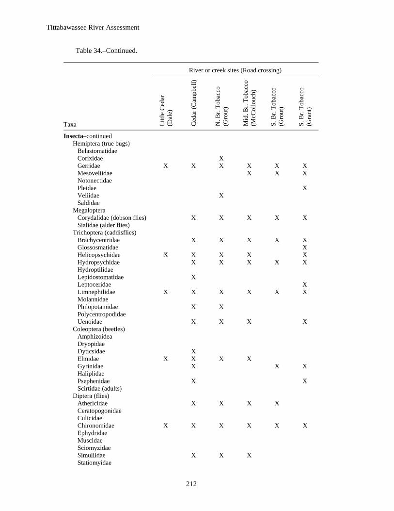
Tittabawassee River Assessment
212
Table 34.–Continued.
River or creek sites (Road crossing)
Taxa Littl
e C
edar
(D
ale)
Ced
ar (C
ampb
ell)
N. B
r. To
bacc
o (G
rout
)
Mid
. Br.
Toba
cco
(McC
ollo
uch)
S. B
r. To
bacc
o (G
rout
)
S. B
r. To
bacc
o (G
rant
)
Insecta–continued Hemiptera (true bugs)
Belastomatidae Corixidae X Gerridae X X X X X X Mesoveliidae X X X Notonectidae Pleidae X Veliidae X Saldidae
Megaloptera Corydalidae (dobson flies) X X X X X Sialidae (alder flies)
Trichoptera (caddisflies) Brachycentridae X X X X X Glossosmatidae X Helicopsychidae X X X X X Hydropsychidae X X X X X Hydroptilidae Lepidostomatidae X Leptoceridae X Limnephilidae X X X X X X Molannidae Philopotamidae X X Polycentropodidae Uenoidae X X X X
Coleoptera (beetles) Amphizoidea Dryopidae Dyticsidae X Elmidae X X X X Gyrinidae X X X Haliplidae Psephenidae X X Scirtidae (adults)
Diptera (flies) Athericidae X X X X Ceratopogonidae Culicidae Chironomidae X X X X X X Ephydridae Muscidae Sciomyzidae Simuliidae X X X Statiomyidae

Tittabawassee River Assessment
213
Table 34.–Continued.
River or creek sites (Road crossing)
Taxa Littl
e C
edar
(D
ale)
Ced
ar (C
ampb
ell)
N. B
r. To
bacc
o (G
rout
)
Mid
. Br.
Toba
cco
(McC
ollo
uch)
S. B
r. To
bacc
o (G
rout
)
S. B
r. To
bacc
o (G
rant
)
Insecta–continued Tabanidae X Tipulidae X X X
Mollusca Gastropoda (snails and limpets)
Ancylidae X X X Lymnaeidae Physidae X X Planorbidae Bithyniidae Pleuroceridae Pomatiopsidae Vivaparidae X X X
Bivalvia (bivalves) Sphaeriidae X X X X X Unionidae X Pisididae

Tittabawassee River Assessment
214
Table 35.–Aquatic macroinvertebrates of the tributaries to the mouth segment Tittabawassee River. Data code: X = present, blank indicates not collected. Data from Cooper (2002).
River or Creek sites (Road crossing) Taxa Carrol (Meridian) Bullock (Poseyville)
Porifera (sponges) X
Bryozoa (moss animals) X
Platyhelminthes (flatworms) Turbellaria X
Annelida (segmented worms) Hirudinea (leeches) Oligochaeta (worms) X
Arthropoda Crustacea
Amphipoda (scuds) X X Decapoda (crayfish) X X Isopoda (sowbugs) X
Arachnoidea Hydracarina (mites)
Insecta Ephemeroptera (mayflies)
Baeticidae X Baetidae X X Caenidae Ephemerellidae Ephemeridae Heptageniidae X X Isonychiidae Syphlomuridae Potamanthidae Tricorythidae
Odonata Anisoptera (dragonflies)
Aeshnidae X X Cordulegastridae Gomphidae X Libellulidae
Zygoptera (damselflies) Calopterygidae X X Coenagrionidae Lestidae Perlodidae
Plecoptera (stone flies) Perlidae Pteronarcyidae
Hemiptera (true bugs) Belastomatidae Corixidae X Gerridae X X Nepidae X

Tittabawassee River Assessment
215
Table 35.–Continued.
River or Creek sites (Road crossing) Taxa Carrol (Meridian) Bullock (Poseyville)
Insecta–continued Notonectidae Pleidae Veliidae Saldidae
Megaloptera Corydalidae (dobson flies) X X Sialidae (alder flies)
Trichoptera (caddisflies) Brachycentridae Glossosmatidae Helicopsychidae Hydropsychidae X Hydroptilidae Lepidostomatidae Leptoceridae X Limnephilidae X X Molannidae Philopotamidae Phryganeidae X X Uenoidae X
Lepidoptera (moths) Nornidae X
Coleoptera (beetles) Amphizoidea Dryopidae Dyticsidae Elmidae X X Gyrinidae Haliplidae X Psephenidae Scirtidae (adults)
Diptera (flies) Athericidae Ceratopogonidae Culicidae X Chironomidae X X Ephydridae Muscidae Sciomyzidae Simuliidae Statiomyidae Tabanidae X Tipulidae X X
Mollusca Gastropoda (snails and limpets)
Ancylidae Lymnaeidae Physidae X X Planorbidae

Tittabawassee River Assessment
216
Table 35.–Continued.
River or Creek sites (Road crossing) Taxa Carrol (Meridian) Bullock (Poseyville)
Mollusca–continued Bithyniidae Pleuroceridae Pomatiopsidae Vivaparidae
Bivalvia (bivalves) Sphaeriidae X X Unionidae Pisididae

Tittabawassee River Assessment
217
Table 36.–Aquatic macroinvertebrates of the Salt River. Data code: X = present, blank indicates not collected. Data from Cooper (2002).
River or Creek sites (Road crossing) Taxa Bluff (Weinert) Salt (Coleman)
Porifera (sponges) Bryozoa (moss animals) X X Platyhelminthes (flatworms)
Turbellaria X Annelida (segmented worms)
Hirudinea (leeches) Oligochaeta (worms) X
Arthropoda Crustacea
Amphipoda (scuds) X X Decapoda (crayfish) X X Isopoda (sowbugs) X
Arachnoidea Hydracarina (mites) X X
Insecta Ephemeroptera (mayflies)
Baeticidae X Baetidae X X Caenidae Ephemerellidae Ephemeridae Heptageniidae X X Isonychiidae Leptophlebiidae Potamanthidae Siphlonuridae X Tricorythidae X X
Odonata Anisoptera (dragonflies)
Aeshnidae X X Corduliidae Gomphidae X X Libellulidae
Zygoptera (damselflies) Calopterygidae X X Perlodidae
Plecoptera (stone flies) Perlidae X Pteronarcyidae
Hemiptera (true bugs) Belastomatidae X Corixidae X X Galastocoridae X Gerridae X X Mesoveliidae

Tittabawassee River Assessment
218
Table 36.–Continued.
River or Creek sites (Road crossing) Taxa Bluff (Weinert) Salt (Coleman)
Notonectidae Pleidae Veliidae Saldidae
Megaloptera Corydalidae (dobson flies) X X Sialidae (alder flies) X X
Trichoptera (caddisflies) Brachycentridae Glossosmatidae Helicopsychidae X Hydropsychidae X X Hydroptilidae Lepidostomatidae Leptoceridae X X Limnephilidae X X Pharyganeidae X Philopotamidae Polycentropodidae Uenoidae X X
Coleoptera (beetles) Amphizoidea Dryopidae Dyticsidae Elmidae X X Gyrinidae Haliplidae X X Psephenidae X X Scirtidae (adults)
Diptera (flies) Athericidae X Ceratopogonidae Culicidae Chironomidae X X Dixidae X Muscidae Sciomyzidae Simuliidae X X Statiomyidae Tabanidae X X Tipulidae X X
Mollusca Gastropoda (snails and limpets)
Ancylidae Lymnaeidae X Physidae X X Planorbidae X
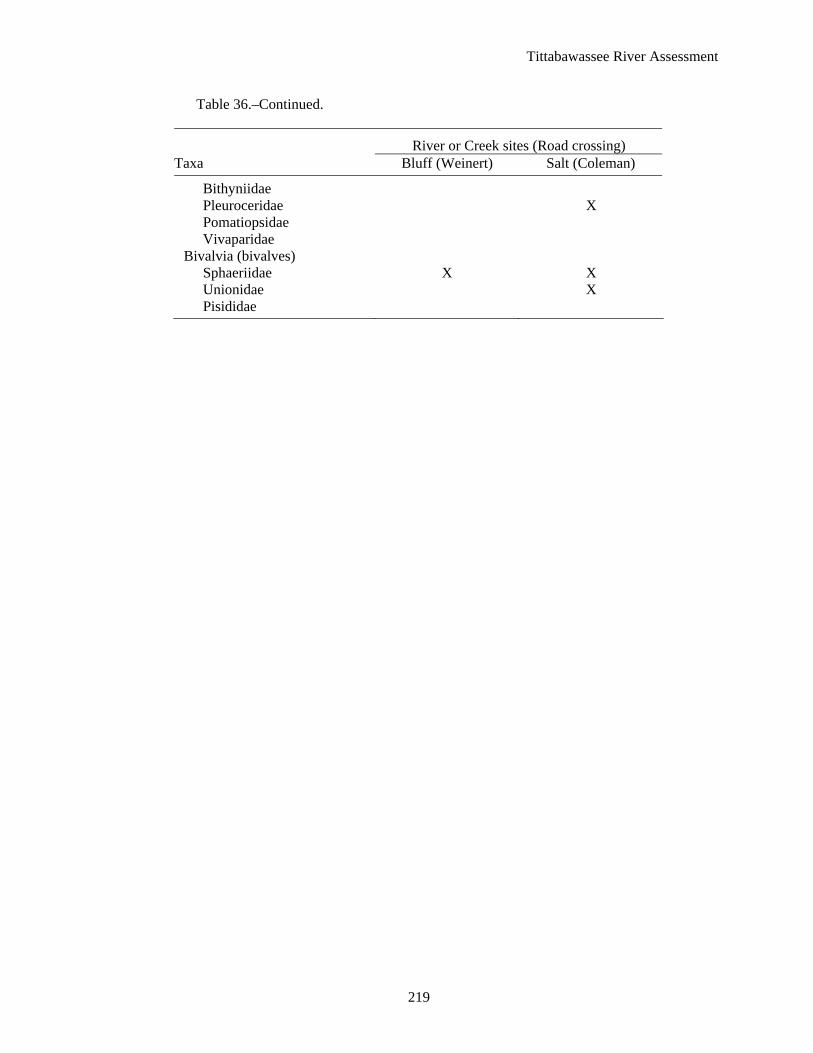
Tittabawassee River Assessment
219
Table 36.–Continued.
River or Creek sites (Road crossing) Taxa Bluff (Weinert) Salt (Coleman)
Bithyniidae Pleuroceridae X Pomatiopsidae Vivaparidae
Bivalvia (bivalves) Sphaeriidae X X Unionidae X Pisididae

Tittabawassee R
iver Assessm
ent
220
Table 37.–Aquatic macroinvertebrates of the Chippewa River. Data code: X = present, blank indicates not collected. Data from Cooper (2002).
River or Creek sites (Road crossing)
Taxa Chi
ppew
a (M
erid
ian)
Chi
ppew
a (M
-20)
Chi
ppew
a (S
.Mer
idia
n)
Chi
ppew
a (C
oldw
ater
)
L. S
alt (
McG
rude
r)
L. S
alt (
9-M
ile)
Salt
(Ala
mon
do)
N. B
r. C
hipp
ewa
east
(S
.Not
taw
a)
N. B
r. C
hipp
ewa
east
(R
oseb
ush)
N. B
r. C
hipp
ewa
east
(S
teve
nson
Lak
e)
Col
dwat
er (B
asel
ine)
Col
dwat
er (V
erno
n)
Porifera (sponges) X X
Bryozoa (moss animals) X X X X X
Platyhelminthes (flatworms) Turbellaria X X X X X X X
Annelida (segmented worms) Hirudinea (leeches) X X X X X X X X X X Oligochaeta (worms) X X
Arthropoda Crustacea
Amphipoda (scuds) X X X X X X X X X X X Decapoda (crayfish) X X X X X X X X X X Isopoda (sowbugs) X X X X X X
Arachnoidea Hydracarina (mites) X X
Insecta Ephemeroptera (mayflies)
Baeticidae X X Baetidae X X X X X X X X X X Caenidae X X X X X X X Ephemerellidae X X X X X Ephemeridae X X X Heptageniidae X X X X X X X X X Isonychiidae X X X Leptophlebiidae
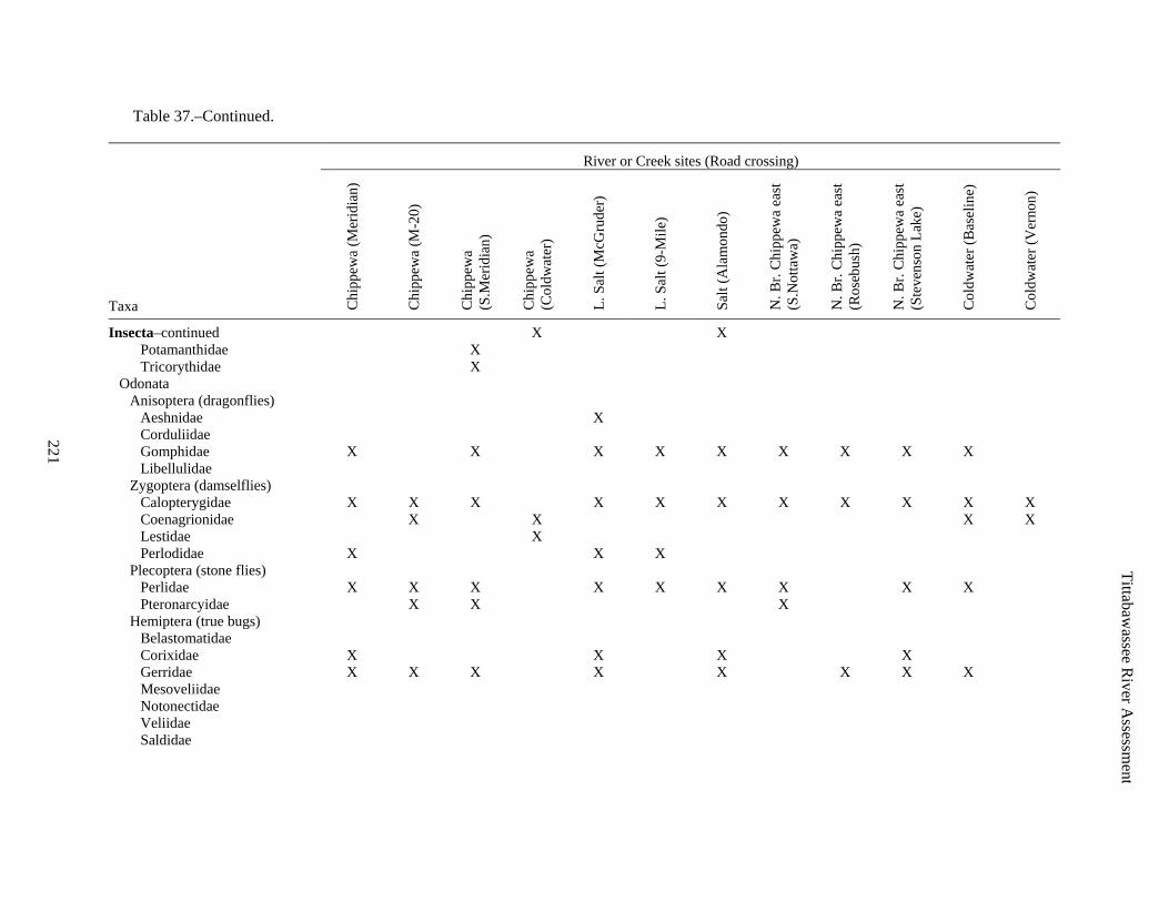
Tittabawassee R
iver Assessm
ent
221
Table 37.–Continued.
River or Creek sites (Road crossing)
Taxa Chi
ppew
a (M
erid
ian)
Chi
ppew
a (M
-20)
Chi
ppew
a (S
.Mer
idia
n)
Chi
ppew
a (C
oldw
ater
)
L. S
alt (
McG
rude
r)
L. S
alt (
9-M
ile)
Salt
(Ala
mon
do)
N. B
r. C
hipp
ewa
east
(S
.Not
taw
a)
N. B
r. C
hipp
ewa
east
(R
oseb
ush)
N. B
r. C
hipp
ewa
east
(S
teve
nson
Lak
e)
Col
dwat
er (B
asel
ine)
Col
dwat
er (V
erno
n)
Insecta–continued X X Potamanthidae X Tricorythidae X
Odonata Anisoptera (dragonflies)
Aeshnidae X Corduliidae Gomphidae X X X X X X X X X Libellulidae
Zygoptera (damselflies) Calopterygidae X X X X X X X X X X X Coenagrionidae X X X X Lestidae X Perlodidae X X X
Plecoptera (stone flies) Perlidae X X X X X X X X X Pteronarcyidae X X X
Hemiptera (true bugs) Belastomatidae Corixidae X X X X Gerridae X X X X X X X X Mesoveliidae Notonectidae Veliidae Saldidae

Tittabawassee R
iver Assessm
ent
222
Table 37.–Continued.
River or Creek sites (Road crossing)
Taxa Chi
ppew
a (M
erid
ian)
Chi
ppew
a (M
-20)
Chi
ppew
a (S
.Mer
idia
n)
Chi
ppew
a (C
oldw
ater
)
L. S
alt (
McG
rude
r)
L. S
alt (
9-M
ile)
Salt
(Ala
mon
do)
N. B
r. C
hipp
ewa
east
(S
.Not
taw
a)
N. B
r. C
hipp
ewa
east
(R
oseb
ush)
N. B
r. C
hipp
ewa
east
(S
teve
nson
Lak
e)
Col
dwat
er (B
asel
ine)
Col
dwat
er (V
erno
n)
Insecta–continued X X Megaloptera
Corydalidae (dobson flies) X X X X X X Sialidae (alder flies)
Trichoptera (caddisflies) Brachycentridae X X Glossosmatidae X Helicopsychidae X X X X X X X X X Hydropsychidae X X X X X X X X X X X Hydroptilidae X Lepidostomatidae X X X X Leptoceridae X Limnephilidae X X X X X X Molannidae X Philopotamidae X Polycentropodidae X X Uenoidae X X X X X X X
Coleoptera (beetles) Amphizoidea X Dryopidae Dyticsidae X X Elmidae X X X X X X X X X X X Gyrinidae X X X X X X X X Haliplidae X X X Psephenidae X X X X Scirtidae (adults)

Tittabawassee R
iver Assessm
ent
223
Table 37.–Continued.
River or Creek sites (Road crossing)
Taxa Chi
ppew
a (M
erid
ian)
Chi
ppew
a (M
-20)
Chi
ppew
a (S
.Mer
idia
n)
Chi
ppew
a (C
oldw
ater
)
L. S
alt (
McG
rude
r)
L. S
alt (
9-M
ile)
Salt
(Ala
mon
do)
N. B
r. C
hipp
ewa
east
(S
.Not
taw
a)
N. B
r. C
hipp
ewa
east
(R
oseb
ush)
N. B
r. C
hipp
ewa
east
(S
teve
nson
Lak
e)
Col
dwat
er (B
asel
ine)
Col
dwat
er (V
erno
n)
Insecta–continued X X Diptera (flies)
Athericidae Ceratopogonidae Chaoboridae Chironomidae X X X X X X X X X X X X Ephydridae Muscidae Sciomyzidae Simuliidae X X X X X X X X X X Statiomyidae X Tabanidae Tipulidae X X X
Mollusca Gastropoda (snails and limpets)
Ancylidae X X Lymnaeidae X X Physidae X X X X X X X X X X Planorbidae X X Bithyniidae Pleuroceridae X X Pomatiopsidae Vivaparidae
Bivalvia (bivalves) Sphaeriidae X X X X X X X X X X X X Unionidae X X X X X Pisididae X

Tittabawassee R
iver Assessm
ent
224
Table 38.–Aquatic macroinvertebrates of the Pine River. Data code: X = present, blank indicates not collected. Data from Cooper (2002).
River or Creek sites {County} (Road crossing or approximate location)
Taxa Pine
{M
idla
nd}
(low
er)
Pine
{M
idla
nd}
(mid
dle)
Pine
{G
ratio
t}
(mid
dle)
Pine
{G
ratio
t}
(upp
er)
Hon
ey {
Gra
tiot}
Unn
amed
{G
ratio
t} (E
ly)
Pine
{M
ontc
alm
}
N. B
r. Pi
ne
{Mon
tcal
m}
Pony
{Is
abel
la}
Pine
{Is
abel
la}
Pony
{Is
abel
la}
S. B
r. Pi
ne
{Isa
bella
}
Jew
ell {
Mec
osta
}
Wol
f {M
ontc
alm
}
Porifera (sponges) X X X
Bryozoa (moss animals)
Platyhelminthes (flatworms) Turbellaria X
Annelida (segmented worms) Hirudinea (leeches) X X X X X Oligochaeta (worms) X X X X X X X X X X
Arthropoda Crustacea
Amphipoda (scuds) X X X X X X X X X X X X X Decapoda (crayfish) X X X X X X X X X X X X X Isopoda (sowbugs) X
Arachnoidea Hydracarina (mites) X X
Insecta Ephemeroptera (mayflies)
Baetidae X X X X X X X X X X X X Caenidae X X X X X X X X X Ephemerellidae X X X Ephemeridae X X X X X X X Heptageniidae X X X X X X X X X X Isonychiidae X X Leptophlebiidae X Potamanthidae X X Tricorythidae X X X X X X X X

Tittabawassee R
iver Assessm
ent
225
Table 38.–Continued.
River or Creek sites {County} (Road crossing or approximate location)
Taxa Pine
{M
idla
nd}
(low
er)
Pine
{M
idla
nd}
(mid
dle)
Pine
{G
ratio
t}
(mid
dle)
Pine
{G
ratio
t}
(upp
er)
Hon
ey {
Gra
tiot}
Unn
amed
{G
ratio
t} (E
ly)
Pine
{M
ontc
alm
}
N. B
r. Pi
ne
{Mon
tcal
m}
Pony
{Is
abel
la}
Pine
{Is
abel
la}
Pony
{Is
abel
la}
S. B
r. Pi
ne
{Isa
bella
}
Jew
ell {
Mec
osta
}
Wol
f {M
ontc
alm
}
Insecta–continued Odonata
Anisoptera (dragonflies) Aeshnidae X X X X X X X X Corduliidae X Gomphidae X X X X X Libellulidae X X
Zygoptera (damselflies) Calopterygidae X X X X X X X X X Coenagrionidae X X X X Perlodidae X X
Plecoptera (stone flies) Perlidae X X X X X X X X X X X Pteronarcyidae X X
Hemiptera (true bugs) Belastomatidae X Corixidae X X X X X X X X X Gerridae X X X X X X X X X X X X X Mesoveliidae X X X Notonectidae X Veliidae X X X Saldidae X
Megaloptera Corydalidae (dobson flies) X X X X X Sialidae (alder flies) X X X
Trichoptera (caddisflies) Brachycentridae X X X X X X X X Glossosmatidae X X X X X

Tittabawassee R
iver Assessm
ent
226
Table 38.–Continued.
River or Creek sites {County} (Road crossing or approximate location)
Taxa Pine
{M
idla
nd}
(low
er)
Pine
{M
idla
nd}
(mid
dle)
Pine
{G
ratio
t}
(mid
dle)
Pine
{G
ratio
t}
(upp
er)
Hon
ey {
Gra
tiot}
Unn
amed
{G
ratio
t} (E
ly)
Pine
{M
ontc
alm
}
N. B
r. Pi
ne
{Mon
tcal
m}
Pony
{Is
abel
la}
Pine
{Is
abel
la}
Pony
{Is
abel
la}
S. B
r. Pi
ne
{Isa
bella
}
Jew
ell {
Mec
osta
}
Wol
f {M
ontc
alm
}
Insecta–continued Helicopsychidae X X X X X X X X Hydropsychidae X X X X X X X X X X Hydroptilidae Lepidostomatidae X Leptoceridae X X X X X X Limnephilidae X X X X X X X X X X X X Molannidae X X Philopotamidae X Polycentropodidae X X Uenoidae X X X X X X X X X
Coleoptera (beetles) Dryopidae Dyticsidae X X X X X X X Elmidae X X X X X X X X X Gyrinidae X X X X X X Haliplidae X X X Psephenidae X X X Scirtidae (adults) X X X
Diptera (flies) Athericidae X Ceratopogonidae X X X X X X X Chaoboridae Chironomidae X X X X X X X X X X X X X X Ephydridae X X X Muscidae X X Sciomyzidae Simuliidae X X X X X X X X

Tittabawassee R
iver Assessm
ent
227
Table 38.–Continued.
River or Creek sites {County} (Road crossing or approximate location)
Taxa Pine
{M
idla
nd}
(low
er)
Pine
{M
idla
nd}
(mid
dle)
Pine
{G
ratio
t}
(mid
dle)
Pine
{G
ratio
t}
(upp
er)
Hon
ey {
Gra
tiot}
Unn
amed
{G
ratio
t} (E
ly)
Pine
{M
ontc
alm
}
N. B
r. Pi
ne
{Mon
tcal
m}
Pony
{Is
abel
la}
Pine
{Is
abel
la}
Pony
{Is
abel
la}
S. B
r. Pi
ne
{Isa
bella
}
Jew
ell {
Mec
osta
}
Wol
f {M
ontc
alm
}
Insecta–continued Statiomyidae X X Tabanidae X Tipulidae X X X X
Mollusca Gastropoda (snails and limpets)
Ancylidae X X X X X Lymnaeidae X X X X X Physidae X X X X X X X X X X X X Planorbidae X X X X Bithyniidae X X Pleuroceridae X Pomatiopsidae Vivaparidae X X
Bivalvia (bivalves) Sphaeriidae X X X X X X X X Unionidae X X X Pisididae X X X X

Tittabawassee R
iver Assessm
ent
228
Table 39.–Occurrence of natural features within the Tittabawassee River watershed. Data from Michigan Department of Natural Resources, Wildlife Division, Natural Features Inventory, May 2006. State status codes: E=endangered, T=threatened, SC=special concern (rare, may become E or T in the future), X=extirpated. Federal status codes: LT=listed threatened, PDL=proposed for de-listing, C=candidate to be listed.
Status Common name or feature Scientific name Federal State Upper Middle Tobacco Mouth Salt Chippewa Pine
Vertebrate Bald eagle Haliaeetus leucocephalus SC X X X X X Blanding's turtle Emys blandingii SC X X X X Common loon Gavia immer T X X X X Common tern Sterna hirundo T X eastern box turtle Terrapene carolina carolina SC X eastern fox snake Elaphe vulpina gloydi T X eastern massasauga Sistrurus catenatus catenatus C SC X Grasshopper sparrow Ammodramus savannarum SC X King rail Rallus elegans E X lake sturgeon Acipenser fluvescens T X Northern goshawk Accipiter gentilis SC X Osprey Pandion haliaetus T X X pugnose shiner Notropis anogenus SC X X Red-shouldered hawk Buteo lineatus T X X X X spotted turtle Clemmys guttata T X wood turtle Clemmys insculpta SC X X X X X X woodland vole Microtus pinetorum SC X X
Invertebrate ebony boghaunter Williamsonia fletcheri SC X elktoe Alasmidonta marginata SC X X X X X ellipse Venustaconcha ellipsiformis SC X X X X hickorynut Obovaria olivaria SC X laura's snaketail Stylurus laurae SC X rainbow Villosa iris SC X rapids clubtail Gomphus quadricolor SC X riverine snaketail Stylurus amnicola SC X round pigtoe Pleurobema coccineum SC X slippershell mussel Alasmidonta viridis SC X X X X X snuffbox Epioblasma triquetra E X X X splendid clubtail Gomphus lineatifrons SC X

Tittabawassee R
iver Assessm
ent
229
Table 39.–Continued.
Status Common name or feature Scientific name Federal State Upper Middle Tobacco Mouth Salt Chippewa Pine
Vascular plant alleghany or sloe plum Prunus alleghaniensis var. davisii SC X beak grass Diarrhena americana T X X blue-eyed-grass Sisyrinchium strictum SC X broad-leaved puccoon Lithospermum latifolium SC X X calypso or fairy-slipper Calypso bulbosa T X Cooper's milk-vetch Astragalus neglectus SC X Engelmann's spike-rush Eleocharis engelmannii SC X false hop sedge Carex lupuliformis T X ginseng Panax quinquefolius T X Hayden's sedge Carex haydenii X X lake cress Armoracia lacustris T X pale beard tongue Penstemon pallidus SC X prairie fringed orchid Platanthera leucophaea LT E X ram's head lady's-slipper Cypripedium arietinum SC X X sedge Carex seorsa T X X showy orchis Galearis spectabilis T X slough grass Beckmannia syzigachne T X small love grass Eragrostis pilosa SC X three-awned grass Aristida longespica T X twinleaf Jeffersonia diphylla SC X Virginia spiderwort Tradescantia virginiana SC X whorled pogonia Isotria verticillata T X
Plant community mesic southern forest X dry-mesic northern forest X rich conifer swamp X bog X
Rookery Great Blue Heron Ardea herodias X X X X X

Tittabawassee River Assessment
230
Table 40.–Mammals of the Tittabawassee River watershed. SC denotes mammals of special concern, mammals extirpated from the Tittabawassee River watershed are denoted * and extinct species **. Data from Burt (1957) and Evers (1994).
Common name Scientific name
Pouched mammals Marsupiala opossum Didelphis virginiana
Shrews, moles, and allies Insectivora eastern mole Scalopus aquaticus starnose mole Condylura cristata masked shrew Sorex cinereus shorttail shrew Blarina brevicauda
Bats and flying mammals Chiroptera little brown myotis Myotis lucifugus keen myotis Myotis keeni silver-haired bat Lasionycteris noctivagans big brown bat Eptesicus fuscus red bat Lasiurus borealis hoary bat Lasiurus cinereus
Rabbits, hares and picas Lagamorpha snowshoe hare Lepus americanus eastern cottontail Sylvilagus floridanus
Rodents Rodentia eastern chipmunk Tamias striatus woodchuck Marmota monax thirteen-lined ground squirrel Spermophilus tridecemlineatus eastern gray squirrel Sciurus carolinensis eastern fox squirrel Sciurus niger red squirrel Tamiasciurus hudsonicus southern flying squirrel Glaucomys volans beaver Castor canadensis white-footed mouse Peromyscus leucopus deer mouse Peromyscus maniculatus meadow vole Microtus pennsylvanicus woodland vole (SC) Microtus pinetorum muskrat Ondatra zibethicus southern bog lemming Synaptomys cooperi Norway rat Rattus norvegicus house mouse Mus musculus meadow jumping mouse Zapus hudsonius porcupine Erethizon dorsatum
Flesh eaters Carnivora gray wolf* Canis lupus coyote Canis latrans red fox Vulpes vulpes gray fox Urocyon cinereoargenteus black bear Ursus americanus raccoon Procyon lotor marten* Martes americana long-tailed weasel Mustela frenata least weasel Mustela nivalis mink Mustela vison

Tittabawassee River Assessment
231
Table 40.–Continued.
Common name Scientific name
American badger Taxidea taxus striped skunk Mephitis mephitis river otter Lutra canadensis cougar* Felis concolor lynx* Lynx canadensis bobcat Lynx rufus
Even-toed ungulates Artiodactyla eastern elk** Cervus elaphus canadensis whitetail deer Odocoileus virginianus woodland caribou* Rangifer tarandus caribou

Tittabawassee River Assessment
232
Table 41.–Breeding bird observations in the Tittabawassee River watershed. Status codes in parentheses and bold (Brewer et. al. 1991).
Common name Scientific name
Loon Gaviidae Common Loon (threatened) Gavia immer
Grebe Colymbidae Pied-billed Grebe Podilymbus podiceps
Herons Ardeidae Great Blue Heron Ardea herodias Green-backed Heron Butorides striatus American Bittern Botaurus lentiginosus Least Bittern (threatened) Ixobrychus exilis
Swans, Geese, and Ducks Anatidae Mute Swan Cygnus olor Canada Goose Branta canadensis Mallard Anas platyrhynchos American Black Duck Anas rubripes Blue Winged Teal Anas discors Wood Duck Aix sponsa Hooded Merganser Lophodytes cucullatus
American Vultures Cathartidae Turkey Vulture Cathartes aura
Hawks Accipitridae Northern Goshawk Accipiter gentilis Sharp-shinned Hawk Accipiter striatus Cooper’s Hawk Accipiter cooperii Red-tailed Hawk Buteo jamaicensis Red-shouldered Hawk (threatened) Buteo lineatus Broad-winged Hawk Buteo platypterus Bald Eagle (special concern) Haliaeetus Ieucicephalus
Grouse Tetraonidae Ruffed Grouse Bonasa umbellus
Pheasants and Quail Phasianidae Northern Bobwhite Colinus virginianus Ring-necked Pheasant Phasianus colchicus
Turkeys Meleagrididae Wild Turkey Meleagris gallopavo
Cranes Gruidae Sandhill Crane Grus canadensis
Rails Rallidae Virginia Rail Rallus limicola Sora Porzana carolina American Coot Fulica americana
Plovers Charadriidae Killdeer Charadrius vociferus

Tittabawassee River Assessment
233
Table 41.–Continued.
Common name Scientific name
Sandpipers Scolopacidae American Woodcock Scolopax minor Common Snipe Gallinago gallinago Spotted Sandpiper Actitis macularia Upland Sandpiper Bartramia longicauda
Pigeons and Doves Columbidae Mourning Dove Zenaida macroura Rock Dove Columba livia
Cuckoos Cuculidae Yellow-billed Cuckoo Coccyzus americanus Black-billed Cuckoo Coccyzus erythropthalmus
Barn Owls Tytonidae Eastern Screech-owl Otus asio Great Horned Owl Bubo virginianus Barred Owl Strix varia Short-eared Owl (endangered) Asio flammeus Whip-poor-will Caprimulgus vociferus Common Nighthawk Chordeiles minor
Swifts Apodidae Chimney Swift Chaetura pelagica
Hummingbirds Trochilidae Ruby-throated Hummingbird Archilochus colubris
Kingfishers Alcedinidae Belted Kingfisher Ceryle alcyon
Woodpeckers Picidae Red-headed Woodpecker Melanerpes erythrocephalus Red-bellied Woodpecker Melanerpes carolinus Downy Woodpecker Picoides pubescens Hairy Woodpecker Picoides villosus Northern Flicker Colaptes auratus Pileated Woodpecker Dryocopus pileatus
Flycatchers Tyrannidae Acadian Flycatcher Empidonax virescens Alder Flycatcher Empidonax alnorum Willow Flycatcher Empidonax traillii Least Flycatcher Empidonax minimus Great Crested Flycatcher Myiarchus crinitus Eastern Kingbird Tyrannus tyrannus Eastern Phoebe Sayornis phoebe Eastern Wood-pewee Contopus virens
Larks Alaudidae Horned Lark Eremophila alpestris Tree Swallow Tachycineta bicolor Bank Swallow Riparia riparia Cliff Swallow Hirundo pyrrhonota Barn Swallow Hirundo rustica

Tittabawassee River Assessment
234
Table 41.–Continued.
Common name Scientific name
Purple Martin Progne subis Northern Rough-winged Swallow Stelgidopteryx serripennis
Jays and Crows Corvidae Blue Jay Cyanocitta cristata American Crow Corvus brachyrhynchos
Titmice Paridae Black-capped Chickadee Parus atricapillus Tuffed Titmouse Parus bicolor
Nuthatches Sittidae Red-breasted Nuthatch Sitta canadensis White-breasted Nuthatch Sitta carolinensis
Creepers Certhiidae Brown Creeper Certhia americana
Wrens Troglodytidae House Wren Troglodytes aedon Winter Wren Troglodytes troglodytes Sedge Wren Cistothorus platensis Marsh Wren Cistothorus palustris
Mockingbirds and Thrashers Mimidae Northern Mockingbird Minnus polyglottos Brown Thrasher Toxostoma rufum Gray Catbird Dumetella carolinensis
Thrushes Turdidae American Robin Turdus migratorius Wood Thrush Hylocichla mustelina Veery Catharus fuscescens Eastern Bluebird Sialia sialis
Gnatcatchers and Kinglets Sylviidae Blue-gray Gnatcatcher Polioptila caerulea Golden-crowned Kinglet Regulus satrapa
Waxwings Bombycillidae Northern Harrier Circus cyaneus American Kestrel Falco sparverius Common Moorhen Gallinula chloropus Cedar Waxwing Bombycilla cedrorum European Starling Sturnus vulgaris Solitary Vireo Vireo solitarius Yellow-throated Vireo Vireo flavifrons Warbling Vireo Vireo gilvus Red-eyed Vireo Vireo olivaceus Blue-winged Warbler Vermivora pinus Golden-winged Warbler Vermivora chrysoptera Nashville Warbler Vermivora ruficapilla Yellow Warbler Dendroica petechia Chestnut-sided Warbler Dendroica pensylvanica Black-throated Blue Warbler Dendroica caerulescens
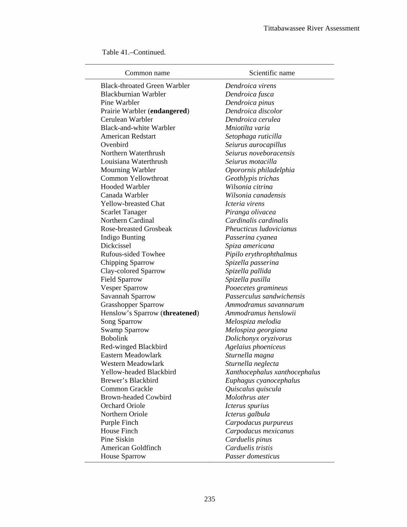
Tittabawassee River Assessment
235
Table 41.–Continued.
Common name Scientific name
Black-throated Green Warbler Dendroica virens Blackburnian Warbler Dendroica fusca Pine Warbler Dendroica pinus Prairie Warbler (endangered) Dendroica discolor Cerulean Warbler Dendroica cerulea Black-and-white Warbler Mniotilta varia American Redstart Setophaga ruticilla Ovenbird Seiurus aurocapillus Northern Waterthrush Seiurus noveboracensis Louisiana Waterthrush Seiurus motacilla Mourning Warbler Oporornis philadelphia Common Yellowthroat Geothlypis trichas Hooded Warbler Wilsonia citrina Canada Warbler Wilsonia canadensis Yellow-breasted Chat Icteria virens Scarlet Tanager Piranga olivacea Northern Cardinal Cardinalis cardinalis Rose-breasted Grosbeak Pheucticus ludovicianus Indigo Bunting Passerina cyanea Dickcissel Spiza americana Rufous-sided Towhee Pipilo erythrophthalmus Chipping Sparrow Spizella passerina Clay-colored Sparrow Spizella pallida Field Sparrow Spizella pusilla Vesper Sparrow Pooecetes gramineus Savannah Sparrow Passerculus sandwichensis Grasshopper Sparrow Ammodramus savannarum Henslow’s Sparrow (threatened) Ammodramus henslowii Song Sparrow Melospiza melodia Swamp Sparrow Melospiza georgiana Bobolink Dolichonyx oryzivorus Red-winged Blackbird Agelaius phoeniceus Eastern Meadowlark Sturnella magna Western Meadowlark Sturnella neglecta Yellow-headed Blackbird Xanthocephalus xanthocephalus Brewer’s Blackbird Euphagus cyanocephalus Common Grackle Quiscalus quiscula Brown-headed Cowbird Molothrus ater Orchard Oriole Icterus spurius Northern Oriole Icterus galbula Purple Finch Carpodacus purpureus House Finch Carpodacus mexicanus Pine Siskin Carduelis pinus American Goldfinch Carduelis tristis House Sparrow Passer domesticus

Tittabawassee River Assessment
236
Table 42.–Amphibians and reptiles in the Tittabawassee River watershed. Data are from Harding and Holman (1990, 1992), Harding (1997) and Michigan Department of Natural Resources, Fisheries Division.
Common name Scientific name
Salamanders mudpuppy Necturus maculosus maculosus eastern newt Notophthalmus viridescens spotted salamander Ambystoma maculatum blue-spotted salamander Ambystoma laterale eastern tiger salamander Ambystoma tigrinum tigrinum red-backed salamander Plethodon cinereus four-toed salamander Hemidactylium scutatum
Frogs and toads eastern American toad Bufo americanus americanus Blanchard’s cricket frog Acris crepitans blanchardi striped chorus frog Pseudacris triseriata northern spring peeper Pseudacris crucifer crucifer eastern gray tree frog Hyla versicolor Cope’s gray tree frog Hyla chrysoscelis bullfrog Rana catesbeiana green frog Rana clamitans melanota wood frog Rana sylvatica northern leopard frog Rana pipiens pickerel frog Rana palustris
Turtles and lizards common snapping turtle Chelydra serpentina serpentina common musk turtle Sternotherus odoratus spotted turtle Clemmys guttata eastern box turtle Terrapene carolina carolina Blanding’s turtle Emydoidea blandingii common map turtle Graptemys geographica painted turtle Chrysemys picta red-eared slider Trachemys scripta elegans eastern spiny softshell turtle Apalone spinifera spinifera five-lined skink Eumeces fasciatus
Snakes northern water snake Nerodia sipedon queen snake Regina septemvittata common garter snake Thamnophis sirtalis Butler’s garter snake Thamnophis butleri northern ribbon snake Thamnophis sauritus septentrionalis brown snake Storeria dekayi northern red-bellied snake Storeria occipitomaculata smooth green snake Opheodrys vernalis blue racer Coluber constrictor foxi black rat snake Elaphe obsoleta obsoleta eastern fox snake Elaphe gloydi eastern milk snake Lampropeltis triangulum triangulum northern ring-necked snake Diadophis nunctatus edwardsii eastern hog-nosed snake Heterodon platirhinos eastern massasauga Sistrurus catenatus catenatus

Tittabawassee R
iver Assessm
ent
237
Table 43.–Fish stocking in the Tittabawassee River watershed, 1995–2005. Data from Michigan Department of Natural Resources, Fisheries Division.
County Location Species Years Numbers Comments
Clare Bertha Lake bluegill 2001 400 private stocking
hybrid sunfish 2005 200 private stocking largemouth bass 2001, 2004 610 private stocking
Budd Lake northern muskellunge 1995, 1997, 2000, 2003 4,321 management stocking redear sunfish 2003, 2004 1,500 private stocking walleye 1995, 1996, 2004 52,694 management and private stocking yellow perch 2004 2,600 private stocking
Eightpoint Lake black crappie 2005 900 private stocking largemouth bass 1989, 1992 700 private stocking walleye 2004 10,965 private stocking yellow perch 2003 20,000 private stocking Lake Thirteen bluegill 2004 800 private stocking hybrid sunfish 2003 1,000 private stocking walleye 1998, 2001, 2002, 2005 3,300 private stocking yellow perch 2003, 2004 1,800 private stocking Little Long Lake black crappie 2001 2,500 private stocking bluegill 2001 2,500 private stocking brown trout 1995–2004 10,991 discontinued 2005 hybrid sunfish 2000 2,000 private stocking rainbow trout 2000–04 14,691 discontinued 2005 Newton Creek brown trout 1995–2005 12,664 management stocking S. Br. Tobacco River brown trout 1995–2005 48,050 management stocking Shamrock Lake walleye 1996 53,433 management stocking,
discontinued Sutherland Lake largemouth bass 1999 357 private stocking

Tittabawassee R
iver Assessm
ent
238
Table 43.–Continued.
County Location Species Years Numbers Comments
Gladwin Blue Lake rainbow trout 2004 500 private stocking Lake Four walleye 1998 522 private stocking Lake Lancer walleye 1995, 1996, 1998, 2000, 2002, 2004 357,480 ongoing management N. Br. Cedar River brown trout 1995–2005 22,945 management stocking Pratt Lake walleye 1996, 1998, 2000, 2002, 2004 119,237 management stocking yellow perch 1996 1,000 private stocking Ross Lake northern muskellunge 1997, 2000, 2003, 2000 5,828 management stocking walleye 2000, 2002, 2004 82,281 management stocking Secord Lake northern muskellunge 1995, 1996, 1997, 2000, 2001, 2004 101,977 management stocking walleye 1995, 1998, 2000, 2002, 2004 244,067 management stocking Smallwood Lake northern muskellunge 1995–1997, 2001, 2004 5,046 management stocking northern pike 2001 44 management stocking walleye 1995, 1996, 1998, 2000, 2003, 2005 244,440 management stocking Trout Lake rainbow trout 2000–02 2,480 management stocking Wiggins Lake bluegill 1999 1,300 private stocking largemouth bass 1995, 1996 1,840 private stocking northern pike 1996, 1999 3,600 management stocking walleye 1995, 1996, 1998, 2000, 2002, 2004 111,581 management stocking yellow perch 1999 2,231 private stocking Wixom Lake northern muskellunge 1996, 1998, 2004 7,202 management stocking
walleye 1995, 1996, 1997, 2000, 2001, 2004 494,212 management stocking Isabella
Chippewa River Chinook salmon 1998, 1999 87 private stocking rainbow trout (steelhead) 1995–2005 145,882 management stocking walleye 1995 2,964 rearing pond release Coldwater Lake northern pike 1995 3,000 management stocking walleye 1996, 1999, 2002 29,328 management stocking Herrick Pond North bluegill 1997 84 restocking largemouth bass 1995 37 restocking

Tittabawassee R
iver Assessm
ent
239
Table 43.–Continued.
County Location Species Years Numbers Comments
Isabella–continued Herrick Pond South northern pike 1999–2000 635 restocking rainbow trout 1995–98 4,230 interim fishery yellow perch 1996, 1997 128 restocking Herrick Swimming Pond largemouth bass 1997 163 restocking Littlefield Lake walleye 2002 9,317 management stocking Pine River brown trout 1995–2005 51,153 management stocking
Mecosta Chippewa Lake walleye 1995, 1997, 1998, 2000, 2003 286,765 management stocking Pretty Lake redear sunfish 1999 1,800 management stocking
walleye 1995, 2001, 2005 3,070 private stocking

Tittabawassee River Assessment
240
Table 44.–Public boat launch sites in the Tittabawassee River watershed by county and water body (MDNR 1996).
County Name of water body Location Ownership
Clare Arnold Lake T20N, R4W, SEC. 35 State Budd Lake T19W, R4W, SEC. 21 State Cranberry Lake T19N, R4W, SEC. 1 State Crooked Lake T17N, R6W, SEC. 22 State Five Lakes T17N, R4W,SEC. 9 State Little Long Lake T19N, R4W, SEC. 22 State Big Mudd Lake T18N, R6W, SEC. 31 State Nester Lake T18N, R3W, SEC. 10 State Perch Lake T17N, R6W, SEC. 23 State Shamrock Lake T17N, R4W, SEC. 26 City
Gladwin House Lake T20N, R2W, SEC. 8 State Lake Four T20N, R1W, SEC. 4 State Lake Lancer T20N, R1W, SEC 21 Township Hoister Lake T20N, R2W, SEC. 9 State Pratt Lake T19N, R2W, SEC. 21 State Ross Lake T17N, R2W, SEC. 12 Township Secord Lake T19N, R1E, SEC. 9 State E. Branch Tittabawassee River T20N, R2E, SEC. 29 State Trout Lake T20N, R2W, SEC. 9 State Wiggins Lake T19N, R2W, SEC. 34 State Wixom Lake T17N, R1W, SEC. 36 State
Gratiot Alma Impoundment T11N, R1W, SEC. 3 City St. Louis Impoundment T12N, R2W, SEC. 25 City
Isabella Coldwater Lake T15N, R5W, SEC. 30 County Halls Lake T14N, R6W, SEC. 19 Township Littlefield Lake T16N, R5W, SEC. 17 State Stevenson Lake T16N, R4W, SEC. 19 State
Mecosta Chippewa Lake T16N, R8W, SEC. 20 State Big Evans (2) T16N, R8W, SEC.35 State Lost Lake T15N, R8W, SEC. 1 State Lower Evans T15N, R8W, SEC. 3 State Pretty Lake T15N, R8W, SEC. 14 State Tubbs Lake T15N, R7W, SEC. 7 State Tubbs Lake T15N, R7W, SEC. 5 State
Midland Sanford Lake T15N, R1W, SEC. 24 County Tittabawassee River T14N, R2E, SEC. 17 City Tittabawassee River T14N, R5E, SEC. 35 City
Montcalm Rock Lake T12N, R5W, SEC.29 Township
Saginaw Tittabawassee River T12N, R3E, SEC. 11 County Tittabawassee River T12N, R4E, SEC. 32 County

Tittabawassee River Assessment
241
Table 45.–Organizations with interests in the Tittabawassee River watershed.
Organization name
Ducks Unlimited
Gladwin County Walleye Association
Izaak Walton League
Little Forks and Chippewa Nature Conservancy
Lone Tree Council
Michigan B.A.S.S. Chapter Federation
Michigan Chapter of American Fisheries Society
Michigan Duck Hunters Association
Michigan Muskie Alliance
Michigan Trappers Association
Michigan United Conservation Clubs District #10
Midland County Sportfishing Association
Mt. Pleasant League of Women Voters
Natural Resource Conservation Service
Nature Conservancy
Pheasants Forever
Pikemasters
Saginaw Bay Walleye Club
Saginaw Field and Stream Club
Saginaw Bay Watershed Initiative Network
Sanford Lake Improvement Board
Sierra Club
Sugar Springs Property Owners Association
Trout Unlimited
Wixom Lake Association
Wixom Lake Improvement Board

Tittabawassee River Assessment
This page was intentionally left blank.
242

Tittabawassee River Assessment
REFERENCES
ATSDR (Agency for Toxic Substance and Disease Registry). 2005. Tittabawassee River fish consumption health consultation. U.S. Department of Health and Human Services, Division of Health Assessment and Consultation. Atlanta.
Albert, D.A. 1994. Regional landscape ecosystems of Michigan, Minnesota, and Wisconsin: a working map and classification. General. Technical Report NC-178. St. Paul, Minnesota: U.S. Department of Agriculture, Forest Service, North Central Forest Experimental Station. Northern Prairie Wildfire Research Center. Available: http://www.npwrc.usgs.gov/resource/habitat/rlandscp/index.htm. (February 2005).
Albert, D.A., S.R. Denton, and B.V. Barnes. 1986. Regional landscape ecosystems of Michigan. University of Michigan, School of Natural Resources, Ann Arbor.
Alexander, G.R., J.L. Fenske, and D.W. Smith. 1995. A fishery management guide to stream protection and restoration. Michigan Department of Natural Resources, Fisheries Division, Special Report 15, Ann Arbor.
Alma College. 2006. The Pine River superfund citizen task force. Available: http://pineriver.alma.edu. (July 2006).
Anonymous. 2002a. Chappel Dam improvements, Sage Township, Gladwin County, Michigan. Engineering cost benefit analysis prepared for Gladwin County Drain Commissioner. Project I.D. Number 104344.01. Spicer Group. Saginaw.
Anonymous. 2002b. Interdepartmental approach to harmful aquatic nuisance species. Michigan Department of Natural Resources and Michigan Department of Environmental Quality, Report to the Michigan Legislature, October 2002, Lansing.
Bailey, R.M., W.C. Latta, and G.R. Smith, 2004. An atlas of Michigan fishes with keys and illustrations for their identification. Miscellaneous Publications Museum of Zoology, University of Michigan, Number 192, Ann Arbor.
Baker, M.E., M.J. Wiley, M.L. Carlson, and P.W. Seelbach. 2003. A GIS model of subsurface water potential for aquatic resource inventory, assessment, and environmental management. Environmental Management (32): 706-719.
Bedell, D.J., and R.L. Van Til. 1979. Irrigation in Michigan-1997. Michigan Department of Natural Resources, Water Management, Lansing.
Berriman, S.J. 1970. Upper Tittabawassee River boom towns. Messersmith Printing, Midland, Michigan.
Brewer, R., G.A. McPeek, and R.J. Adams, Jr. 1991. The atlas of breeding birds of Michigan. Michigan State University Press, East Lansing.
Burt, W.H. 1957. Mammals of the Great Lakes region. University of Michigan Press, Ann Arbor.
Chippewa Nature Center. 2006. About Chippewa Nature Center. Available: http://www.chippewanaturecenter.com. (July 2006).
243

Tittabawassee River Assessment
Chippewa Watershed Conservancy. 2006. What we do. Available: http://www.chippewawatershedconservancy.org/what_we_do.htm. (July 2006).
Cleland, C.E. 1966. The prehistoric animal ecology and ethnozoology of the upper Great Lakes region. University of Michigan, Museum of Anthropology, Anthropological Paper 29, Ann Arbor.
Collins, W.D. 1925. Temperature of water available for industrial use in the United States. United States Geological Survey, Water Supply Paper 520-F, Washington, D.C.
Cooper, J. 2002. A biological survey of the Pine River and selected tributaries in Mecosta, Isabella, Gratiot, Montcalm, and Midland counties. Michigan Department of Environmental Quality, Water Bureau, Staff Report, Lansing.
Cushman, R.M. 1985. Review of ecological effects of rapidly varying flows downstream of hydroelectric facilities. North American Journal of Fisheries Management. 5:330-339.
Deedler, B. 2005. A thumbnail sketch of a great flood in Southeast Michigan. Available: http://www.crh.noaa.gov/dtx/se_flood.htm. (June 2005).
Dewberry, T.C. 1992. Protecting the biodiversity of riverine and riparian ecosystems: the national river public land policy development project. Transactions of the 57th North American Wildlife and Natural Resources Conference. pp. 424-432.
Dodge, K.E. 1998. Raisin River assessment. Michigan Department of Natural Resources, Fisheries Division, Special Report 23, Ann Arbor.
Dorr, J.A. Jr., and D.F. Eschman. 1970. Geology of Michigan. The University of Michigan Press, Ann Arbor.
Dubos, R. 1981. Rivers and Streams. Pages 165-261 in S. Maurizi and F. Poillon, editors. 1992. Restoration of aquatic ecosystems. National Academy Press, Washington, D.C.
Dunbar, W.F., and G.S. May. 1995. Michigan: a history of the wolverine state. 3rd edition. William B. Eerdmans Publishing Company, Grand Rapids.
Ederer, R. 1999. On the banks of the beautiful Saugenah. Thomastown Publishing Company Saginaw, Michigan.
Environmental Science & Engineering Consultants. 1983. Aquatic assessment of the Tittabawassee River in the vicinity of Midland, Michigan. Pearl River, N.Y.
Everitt, B.S. 1998. The Cambridge dictionary of statistics. Cambridge University Press, New York.
Evers, D.C. 1994. Endangered and threatened wildlife of Michigan. University of Michigan Press, Ann Arbor.
Faisal M., and D. Garling. 2004. What is Whirling Disease? North Central Regional Aquaculture Center Fact Sheet Series #113. Available: http://aquahic.org/publicat/USDA_rac/tr/ncrac/tb116.pdf (August 2006).
Farrand, W.R. 1982. Quaternary geology of Michigan. Michigan Department of Natural Resources, Geological Survey Division, color map, Lansing.
244

Tittabawassee River Assessment
Farrand, W.R. 1988. The glacial lakes around Michigan. Michigan Department of Natural Resources, Geological Survey Division, Bulletin 4, Lansing.
Farrand, W.R., and D.F. Eschman. 1974. Glaciation of the southern peninsula of Michigan: a review. Michigan Academician 7:31-56.
FEMA (Federal Emergency Management Agency). 1999. National dam safety program. Washington D.C.
FERC (Federal Energy Regulatory Commission). 1998a. Multiple project environmental assessment for hydropower license. Tittabawassee River projects. FERC Project Nos. 10808, 10809, and 10810. Washington D.C.
FERC (Federal Energy Regulatory Commission). 1998b. Project No. 10809-000. Order issuing minor license. Washington D.C.
FERC (Federal Energy Regulatory Commission). 1998c. Project No. 10810-000. Order issuing minor license. Washington D.C.
FERC (Federal Energy Regulatory Commission). 1998d. Project No. 10808-00. Order issuing original license. Washington D.C.
FERC (Federal Energy Regulatory Commission). 1998e. Project No. 2785-002, 008 and 009. Order on rehearing and amending on license order. Washington D.C.
FERC (Federal Energy Regulatory Commission). 2000. Project No 10808-012. Order approving minimum flow release structure. Washington D.C.
FERC (Federal Energy Regulatory Commission). 2001. Project No. 11428-000. Order issuing minor license. Washington D.C.
FERC (Federal Energy Regulatory Commission). 2004. Project Nos. 2785-046, 10808-026, 10809-021, and 10810-024. Order approving transfer of licenses. Docket # P-2785-046. Washington D.C.
Fielder, D.G. 2002. Sources of walleye recruitment in Saginaw Bay, Lake Huron and options for further recovery. Michigan Department of Natural Resources, Fisheries Division, Research Report 2062, Ann Arbor.
Fielder, D.G., and J.P. Baker. 2004. Strategy and options for completing the recovery of walleye in Saginaw Bay, Lake Huron. Michigan Department of Natural Resources, Fisheries Division, Special Report 29, Ann Arbor.
Fox T.B. 1958. History of Saginaw County, from year 1919 down to the present time. Enterprise Print, East Saginaw, Michigan.
Freshwater Physicians, Inc. 1988. Hydroelectric facilities in the Tittabawassee River basin: potential impacts of operation. Brighton, Michigan.
Hansen, E.A. 1971. Sediment in a Michigan trout stream, its source, movement, and some effects on fish habitat. U.S. Forest Service, Research Paper NC-59, St. Paul, Minnesota.
245

Tittabawassee River Assessment
Harding, J.H. 1997. Amphibians and reptiles of the Great Lakes region. University of Michigan Press, Ann Arbor.
Harding, J.H., and J.A. Holman. 1990. Michigan turtles and lizards. Michigan State University Museum, East Lansing.
Harding, J.H., and J.A. Holman. 1992. Michigan frogs, toads, and salamanders. Michigan State University Museum, East Lansing.
Hay-Chmielewski, E.M., P.W. Seelbach, G.E. Whelan, and D.B. Jester, Jr. 1995. Huron River assessment. Michigan Department of Natural Resources, Fisheries Division, Special Report 16, Ann Arbor.
Hjulstrom, F. 1935. Studies of the morphological activity of rivers as illustrated by the River Fyris. University of Uppsala, Bulletin of the Geological Institute 25:221-527.
Hynes H.B.N. 1970. The ecology of running waters. Liverpool University Press, Liverpool, Great Britain.
Junk, D.J., P.B. Bayley, and R.E. Sparks. 1989. The flood pulse concept in river-floodplain systems. Pages 110-127 in D.P. Dodge, editor. Proceedings of the International Large River Symposium. Canadian Special Publication of Fisheries and Aquatic Sciences 106.
Keenan, H. 2005. Legacies of Isabella County’s early Indian reservation 1855-1872. Available: http://clarke.cmich.edu/reservation/1-comingofchippewas.htm. (October 2005).
Khoury, F. 2004. History of the Chezy formula. Department of Civil and Environmental Engineering, San Diego State University. Available: http://chezy.sdsu.edu. (August 2005).
Legislative Council, State of Michigan. 2006. Natural Resources and Environmental Protection Act 451 of 1994. Available: http://www.legislature.mi.gov/(ycpyju45ceadxxbdx1gygsiv)/mileg.aspx?page=getobject&objectname=mcl-act-451-of-1994&queryid=1013717&highlight (September 2006).
Leonardi J.M. and W.J. Gruhn. 2001. Flint River assessment. Michigan Department of Natural Resources, Fisheries Division, Special Report 27, Ann Arbor.
Little Forks Conservancy. 2006. The Little Forks Conservancy, protecting the places we love for future generations. Available: http://www.littleforks.org (July 2006).
Lockwood, R.N., R.D. Clark, Jr., and J.W. Merna. 1995. Evaluation of catch-and-release fishing regulations for smallmouth bass on the Huron River, Michigan. Michigan Department of Natural Resources, Fisheries Division, Research Report 2016, Ann Arbor.
Madison, G., and R.N. Lockwood. 2004. Manistique River assessment. Michigan Department of Natural Resources, Fisheries Division, Special Report 31, Ann Arbor.
Masterson, M. 1989. Results of a fish flavor impairment study conducted using fish taken from the Tittabawassee River, Midland County, Michigan. October 4, 1989. Michigan Department of Environmental Quality, Surface Water Quality Division, MI/DNR/SWQ-89/161, Lansing.
McMacken, D. 2003. St. Louis at 150. The story of the middle of the mitten. Concept Communications, St. Louis, Michigan.
246

Tittabawassee River Assessment
MDCH (Michigan Department of Community Health). 2001. Dioxins. Available: http://www.michigan.gov/documents/Dioxin_Factsheet_82359_7.pdf. (September 2006).
MDCH (Michigan Department of Community Health). 2005. Dioxins in wild game taken from the Tittabawassee floodplain south of Midland, Midland and Saginaw counties, Michigan. Available: http://www.michigan.gov/documents/Wild_Game_PHC_FINAL_123884_7.pdf. (September 2006).
MDCH (Michigan Department of Community Health). 2007. Michigan Family Fish Consumption Guide. Available: http://www.michigan.gov/mdch/0,1607,7-132-2945_5105-13110--,00.html. (April 2008).
MDEQ (Michigan Department of Environmental Quality). 1997. General rules, water quality standards. Michigan Department of Environmental Quality, Surface Water Quality Division, Lansing.
MDEQ (Michigan Department of Environmental Quality). 1998. Michigan’s relative risk task force report on hydrology. Surface and ground water hydrology alteration task force, Norman Grannemann, Chair. Michigan Department of Environmental Quality, Office of Special Environmental Projects, Lansing.
MDEQ (Michigan Department of Environmental Quality). 2005a. Communities participating in the national flood program. Available: http://www.michigan.gov/deqfloodplainmanagement. (June 2005).
MDEQ (Michigan Department of Environmental Quality). 2005b. Water withdrawals for major water uses in Michigan 2001. Available: http://www.deq.state.mi.us/documents/deq-wd-wurp-TotalWithdrawals2001.pdf. (May 2005).
MDEQ (Michigan Department of Environmental Quality). 2005c. 2001 estimated water withdrawals for agricultural irrigation. Available: http://www.deq.state.mi.us/documents/deq-wd-wurp-Agriculture2001.pdf. (May 2005).
MDEQ (Michigan Department of Environmental Quality). 2006a. Dioxin information. Available: http://www.michigan.gov/deq/0,1607,7-135-3308_21234---,00.html. (February 2006).
MDEQ (Michigan Department of Environmental Quality). 2006b. CSO and SSO discharge information. Available: http://www.deq.state.mi.us//csosso/find_event.asp. (September 2006).
MDEQ (Michigan Department of Environmental Quality). 2007. Coastal and inland waters permit information system. Available: http://www.deq.state.mi.ur/ciwpis/ciwpis.asp. (October 2007).
MDEQ (Michigan Department of Environmental Quality). 2007a. Superfund program overview Available: http://www.michigan.gov/printerFriendly/0,1687,7-135-3311_4109_4217-88632--,00.html. (October 2007).
MDNR (Michigan Department of Natural Resources). 1979. Policies and procedures manual. Michigan Department of Natural Resources, Law Enforcement Division, Lansing.
MDNR (Michigan Department of Natural Resources). 1993. A guide to public rights on Michigan waters. Michigan Department of Natural Resources, Law Enforcement Division, Report Number 9, Lansing.
247

Tittabawassee River Assessment
MDNR (Michigan Department of Natural Resources). 1996. Michigan boat launch directory, 1996. Michigan Department of Natural Resources, Lansing.
MDNR (Michigan Department of Natural Resources). 2004. Michigan Department of Natural Resources, Spatial Data Library. Available: http://www.mcgi.state.mi.us/mgdl/?action=thm. (December 2004).
MDNR (Michigan Department of Natural Resources). 2005. Designated trout streams for the state of Michigan, FO210.06. Available: http://www.michigan.gov/documents/FisheriesOrders_136765_7.htm (February 2006).
MDNR (Michigan Department of Natural Resources). 2006a. Michigan inland trout and salmon guide. Michigan Department of Natural Resources, Fisheries Division, Lansing.
MDNR (Michigan Department of Natural Resources). 2006b. Rusty crayfish (Orconectes rusticus). Available: http://www.michigan.gov/dnr/0,1607,7-153-10370_12145_12203-33021--,00.html. (August 2006).
Mills, J.C. 1918. History of Saginaw County Michigan. Volume 1. Seeman and Peters Publishers, Saginaw, Michigan.
Milstein, R.L. 1987. Bedrock geology of southern Michigan. Michigan Department of Natural Resources, Geological Survey Division, color map, Lansing.
Morris, D.A., and A.I. Johnson. 1967. Summary of hydrologic and physical properties of rock and soil materials, as analyzed by the hydrologic laboratory of the U.S. Geological Survey 1948-60. U.S. Geological Survey, Water Supply Paper 1839-D. Department of the Interior, Government Printing Office, Washington, D.C.
MSU (Michigan State University). 1981. Soils associations map of Michigan. Michigan State University, Agricultural Experimental Station, Cooperative Extension Service, Extension Bulletin E-1550, East Lansing.
MSU (Michigan State University). 2005a. Hydrocarbons: oil and gas (part II). Available: http://www.geo.msu.edu/geo333/oil_and_gasII.html. (May 2005).
MSU (Michigan State University). 2005b. Michigan State University climatological page. Available: http://climate.geo.msu.edu. (April 2005).
NRCS (Natural Resource Conservation Service). 2005. Available: http://www.nrcs.usda.gov/technical/land/mlra/mlralegend.html. (February 2005).
NOAA (National Oceanic and Atmospheric Administration). 2006a. Aquatic invasive species. Available: http://www.miseagrant.umich.edu/ais/index.html. (August 2006).
NOAA (National Oceanic and Atmospheric Administration). 2006b. Mollusks. Available: http://www.miseagrant.umich.edu/ais/mussels.html. (August 2006).
NOAA (National Oceanic and Atmospheric Administration). 2006c. Plants. Available: http://www.miseagrant.umich.edu/ais/plants.html. (August 2006).
O’Neal, R.P. 1997. Muskegon River watershed assessment. Michigan Department of Natural Resources, Fisheries Division, Special Report 19, Ann Arbor.
248

Tittabawassee River Assessment
Public Sector Consultants, Inc. 2002. Targeting environmental restoration in the Saginaw River/Bay Area of Concern (AOC), 2001 Remedial Action Plan Update. Lansing. Michigan.
Quimby, G.I. 1960. Indian life in the upper Great Lakes, 11,000 B.C. to A.D. 1800. University of Chicago Press, Chicago.
Rozich, T. 1998. Manistee River assessment. Michigan Department of Natural Resources, Fisheries Division, Special Report 21, Ann Arbor.
Russell, G.E. 1942. Hydraulics. Henry Holt and Company, New York.
Schiefer, M. 2001. Natural stream processes. Guide no. 03 in Ohio stream management guide. Available: http://www.dnr.state.oh.us/water/pubs/fs_st/stfs03.htm. (August 2005).
Schlosser, I.J. 1991. Stream fish ecology: a landscape perspective. BioScience 41:704-712.
Schneider, J.C., P.W. Laarman, and H. Gowing. 2000. Age and growth methods and state averages. Chapter 9 in J.C. Schneider, editor. Manual of fisheries survey methods II: with periodic updates. Michigan Department of Natural Resources, Fisheries Special Report 25, Ann Arbor.
Seelbach, P.W., M.J. Wiley, J.C. Kotanchik, and M.E. Baker. 1997. A landscape-based ecological classification system for river valley segments in Lower Michigan. Michigan Department of Natural Resources, Fisheries Division, Fisheries Research Report 2036, Ann Arbor.
Smith, B.F., and J.W. Kilar. 1987. Tobico Marsh: a story of the land and the people. Book Crafters, Chelsea, Michigan.
Tody, W.H. 2003. A history of Michigan’s fisheries. Traverse City, Michigan.
Tornado Project. 2005. Tornadoes by state. Available: http://www.tornadoproject.com/alltorns/mitorn.htm (April 2005).
USACE (United States Army Corps of Engineers). 2005a. Section 9 of the River and Harbors Act of 1899. Available: http://www.usace.army.mil/inet/functions/cw/cecwo/reg/rhsec09.htm. (November 2005).
USACE (United States Army Corps of Engineers). 2005b. Section 10 of the River and Harbors Act of 1899. Available: http://www.usace.army.mil/inet/functions/cw/cecwo/reg/rhsec10.htm. (November 2005).
USFWS (United States Fish and Wildlife Service). 2006. Refuge wildlife. Available: http://www.fws.gov/midwest/shiawassee/shiawasseeNWRWidlife.htm. (August 2006).
USGS (United States Geological Survey). 2005. Hydrologic web page. Available: http://nwis.waterdata.usgs.gov/usa/nwis/discharge. (May 2005).
USGS (United States Geological Survey). 2006. NAS – nonindigenous aquatic species. Available: http://nas.er.usgs.gov/queries/Collectioninfo.asp?SpeciesID=5&state=MI (August 2006).
United States Environmental Protection Agency (EPA). 2006. Available: http://www.epa.gov/R5Super/npl/michigan/MID980506281.htm (October 2007).
249

Tittabawassee River Assessment
250
United States Environmental Protection Agency (EPA). 2007a. Available: http://www.epa.gov/R5Super/npl/michigan/MID000722439.htm (October 2007).
United States Environmental Protection Agency (EPA). 2007b. Available: http://www.epa.gov/R5Super/npl/michigan/MID80002273.htm (October 2007).
WRC (Water Resources Commission). 1960. Water resource conditions and uses in the Tittabawassee River basin. State of Michigan, Water Resources Commission, Lansing.
Wesley, J.K. 2005. Kalamazoo River Assessment. Michigan Department of Natural Resources, Fisheries Division, Special Report 35, Ann Arbor.
Wesley, J.K., and J.E. Duffy. 1999. St. Joseph River Assessment. Michigan Department of Natural Resources, Fisheries Division, Special Report 24, Ann Arbor.
Wiley, M.J., and S. Gough. 1995. Fluvial process and stream habitat management short course. Steve Gough & Associates, Stream Ecosystem Management and Research, Champaign, Illinois.
Wiley, M.J., and P.W. Seelbach. 1997. An introduction to rivers – the conceptual basis for the Michigan Rivers Inventory (MRI) project. Michigan Department of Natural Resources, Fisheries Division, Fisheries Special Report 20, Ann Arbor.
Wohl, E.E. 2000. Inland flood hazards: human, riparian, and aquatic communities. Cambridge University Press, Cambridge, United Kingdom.
Yates, D.L. 1987. Salt of the earth: a history of Midland County, Michigan. The Midland Historical Society, Midland, Michigan.
Zorn, T.G., and S.P. Sendek. 2001. Au Sable River assessment. Michigan Department of Natural Resources, Fisheries Division, Special Report 26, Ann Arbor.
Kevin E. Wehrly, Editor Alan D. Sutton, Graphics Ellen S. Grove, Desktop Publishing Approved by E.M. Hay-Chmielewski

Tittabawassee River Assessment
APPENDICES
251

Tittabawassee River Assessment
252
This page was intentionally left blank.

Tittabawassee River Assessment
253
Appendix A.1
Federal Energy Regulatory Commission license covering Secord, Smallwood, Edenville, and Sanford hydroelectric dams. Dams are located in the middle segment of the main stem. The license was issued October 16, 1998.

Tittabawassee River Assessment
254
This page was intentionally left blank.

Tittabawassee River Assessment
255

Tittabawassee River Assessment
256
Tittabawassee River Assessment
257

Tittabawassee River Assessment
258

Tittabawassee River Assessment
259

Tittabawassee River Assessment
260

Tittabawassee River Assessment
261

Tittabawassee River Assessment
262

Tittabawassee River Assessment
263

Tittabawassee River Assessment
264

Tittabawassee River Assessment
265

Tittabawassee River Assessment
266

Tittabawassee River Assessment
267

Tittabawassee River Assessment
268

Tittabawassee River Assessment
269

Tittabawassee River Assessment
270

Tittabawassee River Assessment
271

Tittabawassee River Assessment
272

Tittabawassee River Assessment
273

Tittabawassee River Assessment
274

Tittabawassee River Assessment
275
Appendix A.2 Federal Energy Regulatory Commission license covering the St. Louis Dam, Tributaries – Pine River. The license was issued November 29, 2001.

Tittabawassee River Assessment
276
This page was intentionally left blank.

Tittabawassee River Assessment
277

Tittabawassee River Assessment
278

Tittabawassee River Assessment
279

Tittabawassee River Assessment
280

Tittabawassee River Assessment
281

Tittabawassee River Assessment
282

Tittabawassee River Assessment
283

Tittabawassee River Assessment
284

Tittabawassee River Assessment
285

Tittabawassee River Assessment
286

Tittabawassee River Assessment
287

Tittabawassee River Assessment
288

Tittabawassee River Assessment
289

Tittabawassee River Assessment
290

Tittabawassee River Assessment
291

Tittabawassee River Assessment
292

Tittabawassee River Assessment
293

Tittabawassee River Assessment
294

Tittabawassee River Assessment
295

Tittabawassee River Assessment
296

Tittabawassee River Assessment
297

Tittabawassee River Assessment
298

Tittabawassee River Assessment
299

Tittabawassee River Assessment
300

Tittabawassee River Assessment
301

Tittabawassee River Assessment
302

Tittabawassee River Assessment
303

Tittabawassee River Assessment
304

Tittabawassee River Assessment
305
Appendix A.3 Federal Energy Regulatory Commission exemptions and requirements of the Beaverton hydro-electric dam, Tributaries – Tobacco River. This Commission grant was issued December 31, 1981.

Tittabawassee River Assessment
306
This page was intentionally left blank.

Tittabawassee River Assessment
307

Tittabawassee River Assessment
308

Tittabawassee River Assessment
309

Tittabawassee River Assessment
310

Tittabawassee River Assessment
311

Tittabawassee River Assessment
312

Tittabawassee River Assessment
313
Appendix A.4 Federal Energy Regulatory Commission order approving minimum flow release structure at the Edenville hydro-electric dam. This Commission grant was issued November 15, 2000.

Tittabawassee River Assessment
314
This page was intentionally left blank.
Tittabawassee River Assessment
315

Tittabawassee River Assessment
316

Tittabawassee River Assessment
317
Appendix B Water quality reports available from the Michigan Department of Environmental Quality.

Tittabawassee River Assessment
318
This page was intentionally left blank.

Tittabawassee River Assessment
319
Anonymous. 1955. A biological survey of the Pine River above Alma to M-30 to determine effects of pollution, May 31, 1955. Michigan Department of Environmental Quality Report 000340, Lansing.
Anonymous. 1960. Water resource conditions and uses in the Tittabawassee River basin. Michigan Department of Environmental Quality Report 025590, Lansing.
Anonymous. 1963. A plan for the management of surplus waters of the Tittabawassee River basin. Michigan Department of Environmental Quality Report 025595, Lansing.
Anonymous. 1965. Water quality study, South Branch Tobacco River, 1964. Michigan Department of Environmental Quality Report 025600, Lansing.
Anonymous. 1971. Chippewa River 1968 water quality study in the vicinity of Mt. Pleasant. Michigan Department of Environmental Quality Report 025105, Lansing.
Basch, R., and J.R. Hesse. 1972. Biological survey of the Tittabawassee River, 1971-1972. Michigan Department of Environmental Quality Report 001850, Lansing.
Batchelder, T, and H. Alexander. 1974. Fish survey of the Saginaw River. Michigan Department of Environmental Quality Report 063849, Lansing.
Bohnan, J. E. 1991. Report of toxicity evaluations conducted at Dow Chemical USA, Michigan Division, Midland County, Michigan, August 8-10, 1979. Michigan Department of Environmental Quality, Surface Water Quality Report 91/237, Lansing.
Butler, D. 1997. Acute toxicity assessment of Isabella Co. Landfill Outfall 001 effluent, Mt. Pleasant Michigan, May 5-7, 1997, NPDES Permit No. M10054003. Michigan Department of Environmental Quality, Surface Water Quality Report 97/064, Lansing.
Butler, D. 1997. Chronic toxicity assessment of Dow Chemical USA-Midland Outfall 031 effluent, Midland, Michigan, January 17-24, 1997. Michigan Department of Environmental Quality, Surface Water Quality Report 97/029, Lansing.
Butler, D. 1997. Chronic toxicity assessment of Gladwin WWTP Outfall 001 effluent, Gladwin, Michigan, April 18-25, 1997, NPDES Permit No. M10023001. Michigan Department of Environmental Quality, Surface Water Quality Report 97/057, Lansing.
Butler, D. 1997. Chronic toxicity assessment of Clare WWTP Outfall 001 effluent, Clare, Michigan, June 26-July 2, 1997. Michigan Department of Environmental Quality, Surface Water Quality Report 97/083, Lansing.
Butler, D. 1997. Acute toxicity assessment of Pure Water Perch Farm ambient pond water, Midland, Michigan, Deptember 10-12, 1997. Michigan Department of Environmental Quality, Surface Water Quality Report 97/118, Lansing.
Butler, D. 1998. Acute toxicity assessment of Alpha Plastics Inc, Outfall 001 effluent, June 1998, NPDES Permit No. M10055239, St. Louis, Michigan. Michigan Department of Environmental Quality, Surface Water Quality Report 98/026, Lansing.
Butler D. 2000. Acute toxicity of Velsicol Chemical Corporation Superfund Site excavation dewatering treatment system effluent and Pine River, St. Louis, Michigan, October 5-7, 1999. Michigan Department of Environmental Quality, Surface Water Quality Report 99/157, Lansing.

Tittabawassee River Assessment
320
Butler, D. 2001. Acute toxicity assessment of Isabella County Landfill outfall 001 effluent, Mt. Pleasant, Michigan, December 10-12, 2001. Michigan Department of Environmental Quality, Surface Water Quality Report 01/133, Lansing.
Butler, D. 2001. Acute toxicity assessment of Saginaw TWP WWTP Outfall 001 effluent, Saginaw, Michigan, November 7-9, 2001, NPDES Permit No. M10023973. Michigan Department of Environmental Quality, Surface Water Quality Report 01/125, Lansing.
Butler, D. 2001. Chronic toxicity assessment of US EPA- Velsicol Superfund Site excavation cell dewatering treatment system, outfall 001 effluent, St. Louis, Michigan, August 7-13, 2001. Michigan Department of Environmental Quality, Surface Water Quality Report 01/088, Lansing.
Butler, D. 2001. Chronic toxicity assessment of US EPA- Velsicol Superfund Site excavation cell dewatering treatment system, outfall 001 effluent, St. Louis, Michigan, September 27- October 3, 2001. Michigan Department of Environmental Quality, Surface Water Quality Report 01/099, Lansing.
Butler, D. 2002. Chronic toxicity assessment of Dow Chemical-Midland outfall 031 effluent, Midland, Michigan, March 19-25, 2002, NPDES Permit No. M10000868. Michigan Department of Environmental Quality, Surface Water Quality Report 02/053, Lansing.
Butler, D. 2002. Chronic toxicity assessment of MDEQ-ERD-Gratiot County LF outfall 001 effluent, St. Louis, Michigan, January 22-28, 2002. Michigan Department of Environmental Quality, Surface Water Quality Report 02/045, Lansing.
Butler, D. 2002. Chronic toxicity assessment of Saginaw Township-Center Road LF outfall 004 effluent, Saginaw, Michigan, July 10-12, 2002, NPDES Permit No. M10054739. Michigan Department of Environmental Quality, Surface Water Quality Report 02/098, Lansing.
Butler, D. 2004. Acute toxicity assessment of Total Petroleum Inc-Alma, outfall 001 effluent, Alma Michigan, July 13-15, 2004, NPDES Permit No. M10001066. Michigan Department of Environmental Quality, Water Division Report 04/058, Lansing.
Butler D. 2005. Acute toxicity of US EPA-Velsicol Chemical Corporation Superfund Site treatment plant effluent treated with rerriclear-A1820R water treatment additive, St. Louis, Michigan, October 26-28, 2004. Michigan Department of Environmental Quality, Water Bureau Report 05/013, Lansing.
Butler, D. 2005. Chronic toxicity assessment Mt. Pleasant WWTP, outfall 001 effluent, Mt. Pleasant, Michigan, December 14-21, 2004, NPDES Permit No. M110023655. Michigan Department of Environmental Quality, Water Bureau Report 05/014, Lansing.
Casey, S. 1987. 1982 Tittabawassee River survey at Midland- summary and conclusions. Michigan Department of Environmental Quality, Surface Water Quality Report 96/109, Lansing.
Cooper, J. 2002. A biological survey of the Chippewa River and selected tributaries in Gratiot, Isabella, Mecosta, Montcalm, Midland, and Osceola counties, Michigan, June-August 2002. Michigan Department of Environmental Quality, Water Division Report 02/114, Lansing.
Cooper, J. 2002. A biological survey of the Pine River and selected tributaries in Mecosta, Isabella, Gratiot, Montcalm, and Midland counties, Michigan, July-August 2002. Michigan Department of Environmental Quality, Water Division Report 02/111, Lansing.

Tittabawassee River Assessment
321
Cooper, J. 2003. A reconnaissance survey of the Pine River in Gratiot and Midland counties, Michigan, August 14, 2003. Michigan Department of Environmental Quality, Water Division Report 03/095, Lansing.
Creal W. 1978. Macroinvertebrate monitoring study of the Pine River, Gratiot County, Michigan. Michigan Department of Environmental Quality Report 003180, Lansing.
Creal, W. 1980. Observations on Wolf Creek, vicinity of Hitachi Magnetics, Edmore, August 23, 1980. Michigan Department of Environmental Quality Report 00048, Lansing.
Cornelius, S. 1989. Biological survey of the Cedar River, Gladwin County, Michigan, August 3, 1988. Michigan Department of Environmental Quality, Surface Water Quality Report 89/014, Lansing.
Dimond, W.F. 1987. Toxicity evaluation conducted at Dow Chemical USA, Michigan Division, Midland County, Michigan, NPDES Permit No. M10000868, September 8-12, 1986. Michigan Department of Environmental Quality, Surface Water Quality Report 91/236, Lansing.
Dimond W.F. 1988. Acute toxicity assessment of Mt. Pleasant WWTP. Michigan Department of Environmental Quality, Surface Water Quality Report 88/029, Lansing.
Dimond, W.F. 1989. Acute toxicity assessment of Clare WWTP final effluent, Clare, Michigan, July 19-21, 198, NPDES Permit No. M10020176. Michigan Department of Environmental Quality, Surface Water Quality Report 89/092, Lansing.
Dimond, W.F. 1989. Acute toxicity assessment of CSX derailment site pond overflow, Freeland, Michigan, December 1989. Michigan Department of Environmental Quality, Surface Water Quality Report 89/164, Lansing.
Dimond, W.F. 1989. Acute toxicity assessment of Gladwin WWTP final effluent, Clare, Michigan, July 19-21, 1989. Michigan Department of Environmental Quality, Surface Water Quality Report 89/094, Lansing.
Dimond, W.F. 1989. Acute toxicity assessment of Total Petroleum combined effluent, Alma, Michigan, November 28-30, 1989, NPDES Permit No. M10001066. Michigan Department of Environmental Quality, Water Division Report 89/162, Lansing.
Dimond, W.F. 1993. Aquatic toxicity of Dow Chemical USA, Michigan Division outfall 031 effluent, Midland, Michigan, NPDES Permit No. M10000868, May 29-June 5, 1992. Michigan Department of Environmental Quality, Surface Water Quality Report 93/017, Lansing.
Dimond, W.F. 1995. Acute toxicity assessment of Dow Chemical USA-Midland revetment groundwater interceptor system water, Midland, Michigan, July 31-August 2, 1995. Michigan Department of Environmental Quality, Surface Water Quality Report 95/072, Lansing.
Dimond, W.F. 1996. Chronic toxicity assessment of Dow Chemical USA-Midland outfall 031 effluent, Midland, Michigan, February 27 –March 3, 1995. Michigan Department of Environmental Quality, Surface Water Quality Report 95/072, Lansing.
Dimond, W.F. 1996. Acute toxicity assessment of Dow Chemical USA-Midland Co #22 revetment groundwater interceptor system sample, Midland, Michigan, August 22-29, 1996. Michigan Department of Environmental Quality, Surface Water Quality Report 96/129, Lansing.

Tittabawassee River Assessment
322
Dimond, W.F. 1998. Chronic Toxicity Assessment of Dow Chemical Company, Michigan Operations of outfall 031 effluent, Midland, Michigan, February 20-27, 1998. Michigan Department of Environmental Quality, Surface Water Quality Report 98/016, Lansing.
Dimond, W.F. 1999. Acute toxicity assessment of Velsicol Chemical Corporation Superfund Site, excavation cell sidewall seep sample, St. Louis, Michigan, October 1-3, 1999. Michigan Department of Environmental Quality, Surface Water Quality Report 00/010, Lansing.
Dimond, W.F. 2000. Toxicity reduction evaluation of former Velsicol Chemical Corportation, Superfund Site excavation cell dewatering treatment system, outfall 001 effluent, St. Louis, Michigan, September 19-November 10, 2000. Michigan Department of Environmental Quality, Surface Water Quality Report 00/114, Lansing.
Dimond, W.F. 2001. Acute toxicity assessment of US EPA- Velsicol Superfund Site excavation cell dewatering treatment system combined carbon effluent samples, St. Louis, Michigan, April 30-May 2, 2001. Michigan Department of Environmental Quality, Surface Water Quality Report 01/066, Lansing.
Dimond, W.F. 2001. Acute toxicity assessment of US EPA- Velsicol Superfund Site excavation cell dewatering treatment system combined carbon effluent samples, St. Louis, Michigan, July 24-26, 2001. Michigan Department of Environmental Quality, Surface Water Quality Report 01/094, Lansing.
Dimond, W.F. 2002. Chronic toxicity assessment of TPI-Alma outfall 001 effluent Alma, Michigan, April 16-22, 2002. Michigan Department of Environmental Quality, Surface Water Quality Report 02/070, Lansing.
Dimond, W.F. 2002. Chronic toxicity assessment of US EPA-Velsicol Superfund Site treatment plant effluent, St. Louis, Michigan, August 13-19, 2002. Michigan Department of Environmental Quality, Surface Water Quality Report 02/110, Lansing.
Dimond, W.F. 2002. Chronic toxicity of US EPA-Velsicol Superfund Site treatment plant effluent , St. Louis, Michigan, September 19-25, 2002. Michigan Department of Environmental Quality, Water Division Report 02/117, Lansing.
Dimond, W.F. 2003. Chronic toxicity of US EPA-Velsicol Superfund Site treatment plant effluent, St. Louis, Michigan, October 17-23, 2002. Michigan Department of Environmental Quality, Water Division Report 03/057, Lansing.
Evans, E. 1976. Memorandum to Dave Haywood from Elvin Evans-observations of Atlee’s Canals and proposed dredge areas on Wixom Lake, Gladwin County, Michigan, November 18, 1976- November 26, 1976. Michigan Department of Environmental Quality Report 002700, Lansing.
Evans, E. 1984. Biological effects of a brine spill in Visgar Drain, Larkin Township, Midland County, Michigan, June 4, 1984. Michigan Department of Environmental Quality Report 004690, Lansing.
Evans, E. 1987. Surface water and sediment chemistry in the vicinity of the City of Clare’s landfill, Clare County, Michigan. Michigan Department of Environmental Quality, Surface Water Quality Report 87/017, Lansing.
Fetterolf, C.M. 1957. Bottom fauna samples, Chippewa River, Mt. Pleasant, following a fish kill by cyanide, October, 1957. Michigan Department of Environmental Quality Report 00048, Lansing.

Tittabawassee River Assessment
323
Fetterolf, C.M. 1957. Exploratory bioassay on Copper Versenate, Michigan Chemical Company, St. Louis (Static), August 14, 1957. Michigan Department of Environmental Quality Report 125030, Lansing.
Fetterolf, C.M. 1957. Exploratory bioassay on Copper Versenate, Michigan Chemical Company, St. Louis (Static), September 25, 1957. Michigan Department of Environmental Quality Report 125110, Lansing.
Fetterolf, C.M. 1957. Exploratory bioassay on DDT, Michigan Chemical Corporation, St. Louis, (Static), August 15, 1957. Michigan Department of Environmental Quality Report 125050, Lansing
Fetterolf, C.M. 1957. Exploratory bioassay on DDT, Michigan Chemical Corporation, St. Louis, (Static), July 11, 1957. Michigan Department of Environmental Quality Report 125010, Lansing.
Fetterolf, C.M. 1957. Exploratory bioassay on neutralized DDT, Michigan Chemical Corporation, St. Louis, (Static), July 11, 1957. Michigan Department of Environmental Quality Report 125020, Lansing.
Fetterolf, C.M. 1957. Exploratory bioassay on the Pine River water, St. Louis, (Static), July 12, 1957. Michigan Department of Environmental Quality Report 125030, Lansing.
Fetterolf, C.M. 1960. Bioassay of fish mortality, Kastof Drain, tributary to Tittabawassee River, July 17, 1960. Michigan Department of Environmental Quality Report 125270, Lansing.
Fetterolf, C.M. 1974. Bioassay concerning Dow Chemical Corporation effluents, Midland (Static), September 13, 1957. Michigan Department of Environmental Quality Report 125060, Lansing.
Fetterolf, C.M. 1974. Bioassay on Dow Chemical Company effluents, Midland (Static), September 25, 1957. Michigan Department of Environmental Quality Report 125100, Lansing.
Fetterolf, C.M. 1974. Bioassay on Dow Chemical Company effluents, Midland (Static), December 4, 1957. Michigan Department of Environmental Quality Report 125120, Lansing.
Freed, L.R. 1974. Two 72-hour on-site, continuous-flow bioassays conducted on Ferro Manufacturing Corporation’s wastewater effluent (Outfall 370013), Mt. Pleasant, Michigan, September 24-27, 1974. Michigan Department of Environmental Quality, Water Division Report 91/272, Lansing.
Freed, L.R. 1975. A study of polybrominated biphenyl uptake by caged fish held in the Pine River after termination of polybrominated biphenyl production by the Michigan Chemical Corporation, St. Louis, Michigan, November 27 –December 18, 1974. Michigan Department of Environmental Quality Report 063990, Lansing.
Freed, L.R. 1975. On-site continuous-flow bioassays conducted on two of Michigan Chemical Company’s wastewater discharges (Outfalls No. 2900031 and 290027, Corps. #004), St. Louis, Michigan, September 9, 1975. Michigan Department of Environmental Quality Report 126360, Lansing.
Gates, K. 1995. A reconnaissance of the Pine River at Alma and St. Louis and of Horse Creek, Michigan. Michigan Department of Environmental Quality, Water Division Report 95/033, Lansing.

Tittabawassee River Assessment
324
Hanshue, S. 1994. A biological survey of Horse Creek, Gratiot County, August 23, 1994, Michigan. Michigan Department of Environmental Quality, Water Division Report 94/072, Lansing.
Hanshue, S. 1996. Status of the St. Louis Impoundment in the vicinity of the former Velsicol Chemical Company, Gratiot County, Michigan. Michigan Department of Environmental Quality, Surface Water Quality Report 96/092, Lansing.
Hanshue, S. 2000. Biological and chemical monitoring of the Pine River. Michigan Department of Environmental Quality, Surface Water Quality Report 00/024, Lansing.
Hanshue, S. 2002. Biological and chemical monitoring of the Pine River, Gratiot and Midland counties, June and September 2000 and July and October 2001. Michigan Department of Environmental Quality, Surface Water Quality Report 02/040, Lansing.
Hering, C.M., and G.W. Saalfeld. 1987. Acute toxicity evaluation conducted at Dow Chemical USA, Michigan Division Outfall 031, Midland, Michigan, NPDES Permit No. M10000868, July 21-31, 1987. Michigan Department of Environmental Quality, Surface Water Quality Report 93/041, Lansing.
Hering, C.M., and G.W. Saalfeld. 1987. Acute toxicity of Dow Chemical-USA. Michigan Department of Environmental Quality, Surface Water Quality Report 87/050, Lansing.
Hesse, J.R., and J. Lauer. 1972. Caged rainbow trout taint studies in the Saginaw River watershed, October-November, 1972. Michigan Department of Environmental Quality Report 146550, Lansing.
Hesse, J.R. 1974. Water pollution aspects of polybrominated biphenyl production: results of initial surveys in the Pine River in the vicinity of St. Louis, Michigan, October 17, 1974. Michigan Department of Environmental Quality Report 063910, Lansing.
Hesse, J.R. 1975. Water pollution aspects of polybrominated biphenyl production: results of surveys in Pine River in the vicinity of St. Louis, Michigan. Michigan Department of Environmental Quality, Surface Water Quality Report 96/128, Lansing.
Hull, C. 1986. Aquatic toxicity of effluent discharged by Total Petroleum, Inc., Alma, Michigan, NPDES Permit No. M10001066, October 2-4, 1985. Michigan Department of Environmental Quality, Water Division Report 92/186, Lansing.
Huntly, D. 1990. Stream survey of the South Branch of the Tobacco River in the vicinity of Clare, Michigan, July 15, 1987. Michigan Department of Environmental Quality, Surface Water Quality Report 90/034, Lansing.
Johnson, C. 1980. Biological observations and analysis for phthalates in Overton Creek, Clare County, in the Vicinity of Hoover Universal Chemical Specialties Division discharge, July 26 and September 11, 1979. Michigan Department of Environmental Quality Report 003670, Lansing.
Johnson, C., and W. Creal. 1984. Site-specific unionized ammonia criteria for the Tittabawassee River, April, 1984. Michigan Department of Environmental Quality Report 004660, Lansing.
Jones, R.J. 1997. Sediment contaminant survey, unnamed drain in the vicinity of Hitachi Magnetics Corporation, Montcalm County, Michigan, November 21, 1996. Michigan Department of Environmental Quality, Surface Water Quality Report 97/011, Lansing.

Tittabawassee River Assessment
325
Kanaga, D. 1981. A survey of the North and West Branches of the Chippewa River at Barryton, Mecosta County, November 18, 1981. Michigan Department of Environmental Quality Report 003870, Lansing.
Kanaga, D. 1982. Benthic macroinvertebrate survey of Pony Creek near Remus, Mecosta and Isabella counties, October 5, 1982. Michigan Department of Environmental Quality Report 004130, Lansing.
Kanaga, D. 1983. Water chemistry and benthic macroinvertebrate survey of Pony Creek, Mecosta and Isabella counties, November 11, 1982. Michigan Department of Environmental Quality Report 004250, Lansing.
Kenaga, D. 1984. Biological survey of Salt Creek, Isabella County, Michigan, in the vicinity of Shepherd, August 1983 and October 1984. Michigan Department of Environmental Quality Report 004840, Lansing.
Kenaga, D. 1984. Water chemistry and biological survey of Coldwater River, Isabella County, Michigan, September 16, 1983. Michigan Department of Environmental Quality Report 004760, Lansing.
London, R. 1989. Report of a nonpoint source pollution investigation of the South Branch Tobacco River basin, Clare and Gladwin counties, Michigan, August 16, 1989. Michigan Department of Environmental Quality, Surface Water Quality Report 96/041, Lansing,
London, R. 1989. Report of a nonpoint source pollution investigation of the Tobacco River Basin north and middle branches, Clare County, Michigan, April, 1989. Michigan Department of Environmental Quality, Surface Water Quality Report 96/040, Lansing.
Masterson, M. 1988. Site investigation of Curtis Drain and Mud Creek, Midland County, September 21, 1988. Michigan Department of Environmental Quality, Surface Water Quality Report 88/119, Lansing.
Masterson, M. 1988. Biological survey of Miser Drain and Onion Creek, Isabella County, Michigan, September 21, 1988. Michigan Department of Environmental Quality, Surface Water Quality Report 88/105, Lansing.
Masterson, M. 1988. Site investigation of Visgar Drain, Midland County, July 27, 1988. Michigan Department of Environmental Quality, Surface Water Quality Report 88/093, Lansing.
Masterson, M. 1989. Biological survey of an unnamed tributary of the Chippewa River in the vicinity of Mt. Pleasant, Isabella County, Michigan, September 21, 1988. Michigan Department of Environmental Quality, Surface Water Quality Report 89/006, Lansing.
Masterson, M. 1989. Results of fish flavor impairment study conducted using fish taken from the Tittabawassee River, Midland County, Michigan, October 1989. Michigan Department of Environmental Quality, Surface Water Quality Report 89/161, Lansing.
McMahon, M. 1988. Aquatic toxicity assessment of Alma WWTP final effluent, Alma, Michigan, May 11-13, 1988. Michigan Department of Environmental Quality, Surface Water Quality Report 88/067, Lansing.

Tittabawassee River Assessment
326
McMahon, M. 1989. Acute toxicity assessment of Alma WWTP Final effluent, Alma, Michigan, August 2-4, 1989. Michigan Department of Environmental Quality, Surface Water Quality Report 89/088, Lansing.
McMahon, M. 1992. Aquatic toxicity assessment of the Pine River, Gratiot County, Michigan, June 5-12, 1992. Michigan Department of Environmental Quality, Water Division Report 92/285, Lansing.
McMahon, M. 1992. Aquatic toxicity assessment of the St. Louis WWTP final effluent, St. Louis, Michigan, June 5-12, 1992. Michigan. Michigan Department of Environmental Quality, Water Division Report 92/288, Lansing.
Morse, D. 1990. Biological survey of Pine River, near St. Louis, Michigan (Gratiot and Midland counties), August 23 and 24, 1983-Revised. Michigan Department of Environmental Quality, Water Division Report 90/054, Lansing.
Morse D. 1991. Bioaccumulation study on the Saginaw River and tributaries, August 1, 1988 to September 21, 1988. Michigan Department of Environmental Quality, Surface Water Quality Report 91/009, Lansing.
Morse, D. 1991. Biological survey of North Branch Chippewa River Watershed, Isabella County, Michigan, July 31, 1990. Michigan Department of Environmental Quality, Water Division Report 91/064, Lansing.
Morse, D. 1991. Biological survey of Pine River and tributaries upstream of Alma, Michigan, Gratiot, Isabella, and Montcalm counties, August 23, 1990. Michigan Department of Environmental Quality, Water Division Report 91/034, Lansing.
Morse, D. 1994. A biological survey of the Big Salt River, Isabella County, August 4-14, 1992. Michigan Department of Environmental Quality, Surface Water Quality Report 94/023, Lansing.
Morse, D. 1994. A biological survey of the Chippewa River and selected tributaries, Mecosta, Isabella, and Midland counties. Michigan. Michigan Department of Environmental Quality, Water Division Report 93/031, Lansing.
Morse D. 1994. A biological survey of Sturgeon Creek, Midland County, July 8, 1991. Michigan Department of Environmental Quality, Surface Water Quality Report 92/107, Lansing.
Morse, D. 1994. A biological survey of the Tittabawassee River and selected tributaries, Gladwin, Midland and Saginaw counties, September 11- October 7, 1992. Michigan Department of Environmental Quality, Surface Water Quality Report 93/033, Lansing.
Morse, D. 1994. Biological surveys of the Tobacco River and selected tributaries, Clare and Gladwin counties, June 17-22. 1992, August 30, 1993, and August 18, 1994. Michigan Department of Environmental Quality, Surface Water Quality Report 93/032, Lansing.
Morse, D. 1996. A caged fish study of the Saginaw River and major tributaries, July 18-August 26, 1996. Michigan Department of Environmental Quality, Surface Water Quality Report 95/021, Lansing.
Morse, D. 1997. A biological survey of Pony Creek, Mecosta County, Michigan, September 21, 1997. Michigan Department of Environmental Quality, Surface Water Quality Report 97/020, Lansing.

Tittabawassee River Assessment
327
Michigan Water Resources Commission. 1967. Water resources uses-present and prospective for Lake Huron and water quality standards. Michigan Department of Environmental Quality, Surface Water Quality Report 99/040, Lansing.
Michigan Water Resources Commission. 1970. Investigation of a reported fish kill in Killenbeck Drain below Robert Hafer’s cattle feedlot, Mt. Pleasant, Michigan, July 1970. Michigan Department of Environmental Quality Report 043070, Lansing.
Powers, R.A. 1975. Contamination of ducks from the Pine River, St. Louis, Michigan, with polybrominated biphenyl (PBB), April 1975. Michigan Department of Environmental Quality, Surface Water Quality Report 96/125, Lansing.
Powers, R.A. 1976. Status of polybrominated biphenyl (PBB) contamination of the Pine River in Gratiot and Midland counties, Michigan, August and September, 1976. Michigan Department of Environmental Quality, Water Division Report 91/129, Lansing.
Quinn, D. 1992. Acute toxicity assessment of Saginaw WWTP Outfall 001 Effluent, Saginaw, Michigan, November 6-8, 1991, NPDES Permit No. M10023973. Michigan Department of Environmental Quality, Surface Water Quality Report 92/001, Lansing.
Riley, C.W. 1972. A continuous-flow bioassay of the Total Leonard Refinery, Alma, Michigan, October 9-13, 1972. Michigan Department of Environmental Quality Report 125890, Lansing.
Riley, C.W. 1976. An on-site, toxicity investigation conducted on the process wastewater discharged at outfall 560024 (030) by Dow Chemical Company, Midland Division, Midland County, Michigan, October 13-17, 1976. Michigan Department of Environmental Quality, Surface Water Quality Report 91/234, Lansing.
Robinson, J.G. 1970. Biological survey of the Pine River, vicinity of Alma and St. Louis, 1967 and 1970. Michigan Department of Environmental Quality Report 001690, Lansing.
Rockafellow, D. 2002. A sediment survey of the Pine River From Alma to St. Louis, Gratiot County, Michigan, June 2001. Michigan Department of Environmental Quality, Water Division Report 02/134, Lansing.
Rossio, J. 1989. Fish contaminant monitoring in Michigan, 1984. Michigan Department of Environmental Quality, Surface Water Quality Report 89/071, Lansing.
Saalfeld, G.W., and D. Richards. 1990. Aquatic toxicity assessment of Dow Chemical USA-Michigan Division effluent, Midland, Michigan, May 11-18, 1990, NPDES Permit No. M10000868. Michigan Department of Environmental Quality, Surface Water Quality Report 90/096, Lansing.
Schmidt, G. 2005. Acute toxicity assessment of Isabella Co. Landfill outfall 001 effluent, Mt. Pleasant Michigan, December 14-16, 2004, NPDES Permit No. M10054003. Michigan Department of Environmental Quality, Water Bureau Report 05/003, Lansing.
Schmidt, G. 2005. E. Coli sampling in Sturgeon Creek watershed, Midland. Michigan. Michigan Department of Environmental Quality, Water Bureau 05/008, Lansing.
Seeburger, J. 1969. Pine River chemical survey, January 21, 1969 and February 12, 1969. Michigan Department of Environmental Quality Report 001492, Lansing.

Tittabawassee River Assessment
328
Shauver, J. 1977. Caged fish study at the Alma Wastewater Treatment Plant, June and July, 1977. Michigan Department of Environmental Quality Report 126430, Lansing.
Swanson, D. 1974. Assessment of polybrominated biphenyl contamination in the Pine River, vicinity of Michigan Chemical Company, St. Louis, Michigan, June-August, 1974. Michigan Department of Environmental Quality Report 0063894, Lansing.
Swanson, J. 1980. Report of two on-site toxicity evaluations conducted at Total Petroleum, Inc., all outfalls No. 290006, Gratiot County, Alma, Michigan, June 2-6, 1980. Michigan Department of Environmental Quality, Water Division Report 92/172, Lansing.
Sylvester, S. 1974. A biological survey of the Chippewa River, 1974 staff report. Michigan Department of Environmental Quality Report 02960, Lansing.
Sylvester, S. 1974. A biological survey of the Tittabawassee River, 1974 staff report. Michigan Department of Environmental Quality Report 02990, Lansing.
Truchan, J.G. 1971. Report of a fish mortality in the Tittabawassee River below Dow Chemical Company, Midland, Michigan, July 27, 1971. Michigan Department of Environmental Quality Report 043100, Lansing.
Velz, C.J. 1958. Waste assimilation capacity Tittabawassee River. Michigan Department of Environmental Quality, Surface Water Quality Report 96/106, Lansing.
Vidales, N. 2000. A biological survey of the Tittabawassee River Watershed, Clare, Gladwin, Isabella, and Midland counties, Michigan, June, August and September 1997. Michigan Department of Environmental Quality, Surface Water Quality Report 00/077, Lansing.
Waggoner, C. 1987. Acute toxicity assessment of Hitachi Magnetics Corporation. Michigan Department of Environmental Quality, Surface Water Quality Report 87/040, Lansing.
Wagonner, C. 1988. Biological survey of Gleaneor Drain and Williams Creek, Saginaw County, September 1, 1987. Michigan Department of Environmental Quality, Surface Water Quality Report 88/028, Lansing.
Walker, B. R. 1989. Chronic toxicity evaluation of the Midland Wastewater Treatment Plant effluent, Gladwin, Michigan, July 19-21, 1989. NPDES Permit No. M10023582. Michigan Department of Environmental Quality, Surface Water Quality Report 89/115, Lansing.
Walker, B. 2002. A biological survey of an unnamed tributary of Carrow Creek, Clare County, Michigan, September 17, 2001. Michigan Department of Environmental Quality, Surface Water Quality Report 02/049, Lansing.
Water Resources Commission. 1967. Water resources uses-present and prospective for Lake Huron and water quality standards. Michigan Department of Environmental Quality, Surface Water Quality Report 99/040, Lansing.
Waybrant, R. 1974. A study of polybrominated biphenyl uptake by caged fish held in the Pine River, vicinity of the Michigan Chemical Company, St. Louis, Michigan, October 1974. Michigan Department of Environmental Quality, Surface Water Quality Report 96/127, Lansing.

Tittabawassee River Assessment
329
Waybrant, R. 1975. The effects of aerial spraying with sevin-4-oil on the macroinvertebrates in Woodward Creek, Skunk Creek and the North Branch Pine River. Michigan Department of Environmental Quality Report 063960, Lansing.
Willson, R. 1967. Chippewa River investigation with reference to fingernail clam mortality. Michigan Department of Environmental Quality Report 043100, Lansing.
Willson, R. 1967. Observations on the Chippewa River, vicinity of Mt. Pleasant, Isabella and Midland counties, Michigan, August 24, 1967. Michigan Department of Environmental Quality Report 001110, Lansing.
Willson, R. 1971. Report of caustic spill to the Tittabawassee River by Dow Chemical Company, Midland, Michigan. August 13, 1971. Michigan Department of Environmental Quality Report 043110, Lansing.
Wuerthele, M. 1971. A continuous-flow bioassay of the Dow Chemical Company Effluent, Midland Michigan, August 30-September 3, 1971. Michigan Department of Environmental Quality Report 125771, Lansing.
Wuerthele, M. 1973. Two continuous-flow bioassays conducted on the St. Louis Wastewater Treatment Plant final effluent, October 29, 1973. Michigan Department of Environmental Quality Report 126220, Lansing.
Wuerhele, M. 1991. Caged fish study in the Tittabawassee River above and below the Dow Chemical Company discharges, Midland, Michigan, August 27-September 2, 1971. Michigan Department of Environmental Quality, Surface Water Quality Report 91-118, Lansing.
Wuerhele, M. 1992. Biomonitoring study conducted in the vicinity of the Dow Chemical Company, Midland, Michigan, 1972. Michigan Department of Environmental Quality, Surface Water Quality Report 91/223, Lansing.
Wuycheck, J. 2000. A biological assessment of the Coldwater River, Isabella County, Michigan, October 2, 2000. Michigan Department of Environmental Quality, Surface Water Quality Report 00/078, Lansing.
Wuycheck, J. 2001. A sediment loading source identification survey in the upper reaches of the Coldwater River, Isabella County, Michigan, November 17, 2000. Michigan Department of Environmental Quality, Surface Water Quality Report 00/116, Lansing.
Wuycheck, J. 2001. Suspended solids and bedload monitoring of the Coldwater River, Isabella County, Michigan, May 4-July 29 1999. Michigan Department of Environmental Quality, Surface Water Quality Report 00/081, Lansing.
Yohn, S., Long, D. and J. Giesy. 2003. Inland lakes sediment trends: sediment analysis results for two Michigan lakes, final report: 2000-2001, Crystal Lake and Littlefield Lake. Michigan Department of Environmental Quality, Water Division Report 02/115, Lansing.