table of content - hppcb.nic.inhppcb.nic.in/nandieia.pdf · nandi stone crusher for river bed...
TRANSCRIPT

i
TABLE OF CONTENTS
CHAPTER-1: INTRODUCTION
1.1 Preamble 1
1.2 General Information of Mines 2
1.3 Details of Project Proponent 2
1.4 Mine Lease status 3
1.5 Brief Description of the Project 3
1.5.1 Size of the project 3
1.5.2 Location of the project 3
1.6 Post-Environmental Clearance Monitoring 7
1.7 Generic structure of Environmental Impact Assessment 8
1.8 Analysis of Alternatives 8
1.8.1 Analysis of Alternative sites 8
1.8.2 Analysis of Alternative technology 9
1.9 Importance to the country and region 9
1.10 Scope of EIA study 9
CHAPTER-2: PROJECT DESCRIPTION
2.1 Location of the project 10
2.2 Land use pattern of lease area 11
2.3 Physiography 11
2.3.1 Ridges 12
2.3.2 Drainage 12
2.3.3 Springs 12
2.4 Description of Chakki River & Catchment Area 12
2.5 Regional Geology & Local Geology 15
2.5.1 Local Geology 16
2.6 Rainfall 17
2.7 Mining area, reserves of deposits and mining methodology 19
2.7.1 Exploration 20
2.7.2 Mineable reserves 20
2.7.3 Mining method 20

ii
2.8 Employment Generation 22
2.9 Rate of production 22
2.10 Waste generation 22
2.11 Transportation 23
CHAPTER-3: DESCRIPTION OF ENVIRONMENT
3.1 Introduction 24
3.2 Study area at a glance 24
3.3 Land use/Land cover study 25
3.4 Physiography and Drainage pattern 26
3.5 Sensitivity and Flood hazard Zonation 27
3.6 Instruments used for environmental baseline data collection 27
3.7 Water environment 28
3.7.1 Ground water 28
3.7.2 Ground water quality 29
3.7.3 Methodology 29
3.7.4 Water sampling locations 29
3.7.5 Presentation of results 31
3.7.6 Observations 33
3.8 Meteorology 34
3.8.1 Methodology 34
3.8.2 Meteorology data recorded at proposed project site 34
3.8.3 Meteorology data 34
3.8.4 Wind pattern during study period 39
3.9 Ambient air environment 39
3.9.1 Air quality 39
3.9.2 Ambient air monitoring 41
3.9.3 Methodology adopted for air quality survey 41
3.9.4 Frequency and parameters for sampling 43
3.9.5 Instruments used for sampling 43
3.9.6 Sampling and analytical techniques 43
3.9.7 Presentation of results 44
3.10 Noise environment 49
3.10.1 Identification of sampling locations 49

iii
3.10.2 Method of monitoring 50
3.10.3 Presentation of results 52
3.10.4 Observation of results 52
3.11 Soil environment 53
3.11.1 Soil quality and characteristics 53
3.11.2 Baseline soil status 54
3.12 Ecological studies 57
3.12.1 Flora 57
3.12.2 Fauna in the study area 62
3.13 Socio economic environment 65
3.13.1 Methodology adopted for the study 65
3.13.2 Review of demographic and socio-economic profile-2001 66
3.13.3 Occupational structure in buffer zone 66
3.13.4 Health status 66
3.13.5 Socio-economic survey 67
3.13.6 Awareness and opinion about the project 67
3.13.7 Civic amenities 67
3.13.8 Note on agriculture development and role of incoming project 68
3.14 Conclusion 71
Chapter-4: ANTICIPATED ENVIRONMENTAL IMPACTS AND MITIGATION MEASURES
4.1 Environmental Impact Assessment 72
4.2 Environmental Impact Assessment and Mitigation measures 72
4.2.1 Impact on air quality and mitigation measures 72
4.3 Impact of Noise/Vibrations & mitigation measures 74
4.3.1 Impact of noise on working environment 74
4.3.2 Noise abatement and control 74
4.4 Impact on water environment and mitigation measures 75
4.4.1 Impact on surface water 75
4.4.2 Mitigation measures for water environment &water conservation 75
4.4.3 Rain water harvesting 75
4.5 Biological environment 75
4.5.1 Impact on terrestrial ecology 76
4.5.2 Impact on flora 76

iv
4.5.3 Impact on fauna 76
4.6 Impact on soil and land use pattern & mitigation measures 77
4.6.1 Impact of change of land use 77
4.7 Socio economic environment 77
4.8 Impact on local transport/infrastructure 77
4.9 Impact of cumulative mining in surrounding area 77
4.10 Impact on civic amenities 77
4.11 Occupational health and safety 78
CHAPTER-5 : ENVIRONMENTAL MONITORING PROGRAMME
5.1 Introduction 80
5.2 Formation of EMC(Environmental Management Cell) 80
5.2.1 Responsibility of EMC 80
5.3 Measurement methodologies 81
5.3.1 Instruments to be used 81
5.3.2 Monitoring program 81
5.4 Environmental monitoring and reporting procedures 81
5.4.1 Objectives of monitoring 82
5.5 Environmental monitoring 82
5.6 Monitoring methods 85
5.6.1 Air quality modeling 85
5.6.2 Water quality monitoring 85
5.6.3 Noise levels 86
5.7 Reporting schedules of monitoring data 86
5.8 Data analysis 86
5.9 Detailed budget 86
CHAPTER-6: ADDITIONAL STUDIES
6.1 Introduction 87
6.2 Public consultation 87
6.3 Risk assessment and disaster management plan 87
6.3.1 Definition 87
6.3.2 Scope 87
6.3.3 Objectives 88
6.4 Disaster management plan 88

v
6.5 Occupational health and safety 88
6.5.1 Occupational health 88
6.5.2 Safety plan 89
6.5.3 Safety organisation 89
6.5.4 Health and safety monitoring plan 89
6.6 Natural resource conservation 90
6.7 R&R action plan 90
6.8 Corporate Social Responsibility (CSR) 90
6.9 Identification of hazards 90
6.9.1 Disaster due to surface fire 90
6.9.2 Code of practice in case of explosions&accidents 91
6.9.3 Action in emergency 92
6.9.4 Site restoration 92
6.9.5 Precautions 92
6.9.6 Post disaster analysis and evaluation 92
6.9.7 Off site emergency plan 93
CHAPTER-7 : PROJECT BENEFITS
7.0 Introduction 96
7.1 Demography Benefits 96
7.2 Education 96
7.3 Employment 96
7.4 Conclusion 97
CHAPTER-8 : ENVIRONMENTAL MANAGEMENT PLAN
8.1 Introduction 98
8.2 Pollution control measures 99
8.2.1 Air pollution control 99
8.2.2 Prevention and control of dust pollution 99
8.3 Noise environment 100
8.4 Water environment 101
8.4.1 Surface water 101
8.4.2 Ground water 101
8.5 Land environment 101
8.5.1 Plantation and soil conservation 102

vi
8.5.2 Post mining land use 102
8.6 Biological environment 102
8.6.1 Mitigation of impacts on biological environment 102
8.7 Occupational health and safety measures 103
8.7.1 Occupational health hazards at mine site 103
8.7.2 Implementation of occupational health and safety measures 103
8.8 Environmental monitoring program 104
8.9 Socio economic environment/corporate social responsibility 104
8.10 Cost provision for environmental measures 105
8.11 Conclusion 105
CHAPTER-9 : SUMMARY AND CONCLUSIONS
9.1 Introduction 106
9.2 Justification for the project 106
9.3 Brief description of the project 107
9.4 Mining details 108
9.5 Mitigation measures 108
9.5.1 Strategy to control air pollution 108
9.5.2 Reclamation plan for land use 108
9.5.3 Strategy to control water pollution 109
9.5.4 Noise abatement and control 109
9.5.5 Solid waste mitigation measures 109
9.5.6 Green belt development 110
9.6 Conclusion 110
CHAPTER-11 : DISCLOSURE OF CONSULTANTS
LIST OF TABLES
Table No. Title P.No.
Table-1.5.1 Brief description of the project 4
Table-2.3.1 Distance of the major towns/habitations from the mine lease area 12
Table-2.5.2 Water requirement details 13
Table-2.7.1 Straitigraphy of the region 15
Table-2.7.2 Litho-units exposed in the area 17
Table-2.7.3 Details of bench wise deposits 18

vii
Table-2.8.1 Year wise production plan for first five years 19
Table-2.8.2 Details of waste generation in five years 20
Table-2.8.3 Bench wise waste generation 20
Table-3.3.1 Land use pattern of the villages surrounding the mining lease 26
Table-3.7.1 Details of water sampling locations 30
Table-3.7.2 Results of ground water quality 32
Table-3.7.3 Results of surface water quality 33
Table-3.8.1 Meteorological data recorded at mine site in April-2012 35
Table-3.8.2 Meteorological data recorded at mine site in May-2012 36
Table-3.8.3 Meteorological data recorded at mine site in June-2012 37
Table-3.9.1 Details of ambient air quality monitoring locations 40
Table-3.9.2 Monitored parameters and frequency of sampling 42
Table-3.9.3 Techniques used for ambient air quality monitoring 42
Table-3.9.4 Ambient air quality monitoring results-A1,A2,A3 43
Table-3.9.5 Ambient air quality monitoring results-A4,A5,A6 44
Table-3.9.6 Summary of ambient air quality monitoring 45
Table-3.9.7 National ambient air quality standards 46
Table-3.10.1 Details of noise monitoring locations 48
Table-3.10.2 Results of ambient noise quality monitoring 50
Table-3.10.3 Statistical analysis results of ambient noise monitoring 51
Table-3.10.4 Ambient noise quality standards 51
Table-3.11.1 Soil sampling locations 52
Table-3.11.2 Soil analysis results 54
Table-3.11.3 Standard soil classification 54
Table-3.12.1 Details of ecological sampling locations 57
Table-3.12.2 Flora in the study area 61
Table-3.12.3 Fauna in the study area 63
Table-3.12.4 Common mammals and birds in the Kangra district 64
Table-3.13.1 Demography details of study area (%km buffer zone) 70
Table-4.2.1 Emission rates and emission conditions 71
Table-5.5.1 Environmental monitoring during operational phase 83
Table-9.3.1 Description of the project 107
Table-9.4.1 Mining details 108

viii
LIST OF FIGURES
Figure No. Title P.No.
Figure-1.5.1 Location of mine lease area 5
Figure-1.5.2 Environmental setting of the area 6
Figure-1.5.3 Site photographs showing environmental setting of the area 7
Figure-2.3.1 Location of mine lease area on Survey of India toposheet 11
Figure-3.5.1 Seismic zone map of India 27
Figure-3.7.1 Water sampling locations 31
Figure-3.8.1 Site specific wind rose diagram 40
Figure-3.9.1 Ambient air quality monitoring locations 42
Figure-3.10.1 Noise monitoring locations 50
Figure-3.11.1 Soil sampling locations 54
Figure-3.12.1 Ecological sampling locations 59
LIST OF ANNEXURES Annexure No. Title
Annexure-I Permanent Registration Certificate
Annexure-II Mine lease grant Letter
Annexure-III Terms of Reference
Annexure-IV NOC from Gram Panchayat
Sand, Stone and Bajri mine (ML- Area – 8-64-00 ha Proposed capacity 67500 TPA at khasra no. 527/495/2/1, Mohal –Pail, Mauza-Khanni, Tehsil Nurpur, District –Kangra (H.P)
EIA Executive Summary
1
EXECUTIVE SUMMARY
OF
ENVIRONMENTAL IMPACT ASSESSMENT REPORT
(Submitted for Public Consultation as per EIA Notification)
IN FAVOUR OF
Sh. Sham Singh
Prop: M/s. NANDI STONE CRUSHER
FOR RIVER BED MINING OF MINOR MINERALS: SAND, STONE AND BAJRI
SITUATED IN KHASRA NO. 527/495/2/1
FALLING IN MAUZA KHANNI, TEHSIL-NURPUR,
DISTRICT KANGRA, HIMACHAL PRADESH
CONSULTANT
M/s. IDMA LABORATORIES LIMITED
391, Industrial Area, Phase-I
Panchkula, Haryana
Ph.0172-5064827 Fax-0172-2583587

Sand, Stone and Bajri mine (ML- Area – 8-64-00 ha Proposed capacity 67500 TPA at khasra no. 527/495/2/1, Mohal –Pail, Mauza-Khanni, Tehsil Nurpur, District –Kangra (H.P)
EIA Executive Summary
2
TABLE OF CONTENT Chapter No. Contents P. No.
1.0 Project Description 3
1.1 Introduction 3
1.2 Details of the Project 3
2.0 Technology and specifications of inputs 5
2.1 Size and magnitude of operation 5
2.2 Extent of Mechanization 5
2.3 Anticipated life of the mine 5
2.4 Proposed method of mining 5
3.0 Description of the Environment 5
3.1 Climatic conditions 6
3.2 Air Quality 6
3.3 Noise levels 6
3.4 Water Quality 7
3.5 Soil Quality 7
3.6 Biological Environment 7
3.7 Socio economic studies 8
4.0 Environment Monitoring Plan 8
5.0 Anticipated Environmental impacts, mitigation measures
and Environmental Management Plan
10
5.1 Air pollution control 10
5.2 Noise control measures 10
5.3 Water management 10
6.0 Occupational Health and Safety 11
7.0 Greenbelt Development 11
8.0 Project Benefits 11
TABLES
Table-1 Brief description of nature,size,location of the project and its importance
to the country and region
4
Table-2 Environmental Monitoring Programme 8

Sand, Stone and Bajri mine (ML- Area – 8-64-00 ha Proposed capacity 67500 TPA at khasra no. 527/495/2/1, Mohal –Pail, Mauza-Khanni, Tehsil Nurpur, District –Kangra (H.P)
EIA Executive Summary
3
EXECUTIVE SUMMARY 1.0 PROJECT DESCRIPTION 1.1 INTRODUCTION
M/s. Nandi Stone Crusher, a part concern, with Sh. Sham Singh, Village & P.O. Lahru, Tehsil
Jawali, District Kangra, Himachal Pradesh. The mining lease was transferred to them, along with
approval for second renewal, for mining sand, stone and bajri vide letters Nos. Udyog-Bhu (Khani-4) Laghu-502/09-6076 dated 13.9.2010 for a period of five year. The stone was used in a captive
stone crushing unit.
The project involves mining / collection of 68000 MTPA of sand, stone and bajri from old river
terrace of Chaki Khad for a stone crushing unit to be set by the project proponent. The total area of
mine lease is 8-64-00 Hectares. The proponent has been granted mining lease for mining of sand,
stone and bajri vide order no. Udyog – Bhu (Khani - 4) Laghu –502/09-6076 dated 13.9.2010 attached as Annexure II, for a period of five years.
As per the New EIA Notification dated 14 September, 2006, the mining project falls under category
‘A’, project activity 1(a) (3). Therefore, this project requires Environmental Clearance from MoEF,
New Delhi. This mining project falls in category-A as the site is situated within 10 Km of interstate
boundary with Punjab. The Environmental Impact Assessment (EIA) and Environmental
Management Plan for “Mining of Minerals” as per the EIA Notification, 14th September 2006 has
been prepared in accordance to Terms of reference issued by the Ministry of Environment & Forest
vide their letter No. J – 11015/213/2011 – IA.II (M) dated 1st November, 2011 and the Environmental
Impact Assessment Guidance Manual published by MoEF for grant of environmental clearance with
relevant project specific data. All these mining projects are statutorily required to conduct
Environmental Impact Assessment study for obtaining environmental clearance

Sand, Stone and Bajri mine (ML- Area – 8-64-00 ha Proposed capacity 67500 TPA at khasra no. 527/495/2/1, Mohal –Pail, Mauza-Khanni, Tehsil Nurpur, District –Kangra (H.P)
EIA Executive Summary
4
1.2 DETAILS OF THE PROJECT
TABLE-1 BRIEF DESCRIPTION OF NATURE, SIZE, LOCATION OF THE PROJECT AND ITS
IMPORTANCE TO THE COUNTRY, REGION
S. No. Particulars Details A. Nature of project Mining Project B. Size of project 1. Mining Lease area 8-64-00 Hectares 2. Proposed Production capacity 67500 MTPA C. Project Location 3. Villages Pail 4. Tehsil Nurpur 5. District Kangra 6. State Himachal Pradesh 7. Latitude 320 17 ’ 25.3 ” N to 320 17’ 40.7 ” N 8. Longitude 750 46 ’ 31.2” E to 750 46’ 46’43 ” E 9. Toposheet No. 43P/15 D. Environmental Settings Details 10. Nearest Major Town Pathankot (12 km) 11. Nearest State Highway Nurpur – Kadwal Road 12. Nearest Railway Station Pathankot (12 km) 13. Nearest Airport Dharamshala ( 75 km )
14. Ecological Sensitive Areas (National Park, Wild Life Sanctuaries, Biosphere Reserves etc.)
Nil within the 10km radius
15. Nearest River Chaki River 16. Seismic Zone Seismic Zone - V E. Cost Details 17. Total Project Cost Annual Turnover- Rs. 5088000/=
18. Cost for Environmental Protection Measures
Capital Cost - Rs. 3,50,000/= Recurring Cost – Rs.70,000/=
Source: Site Visit & Mining plan

Sand, Stone and Bajri mine (ML- Area – 8-64-00 ha Proposed capacity 67500 TPA at khasra no. 527/495/2/1, Mohal –Pail, Mauza-Khanni, Tehsil Nurpur, District –Kangra (H.P)
EIA Executive Summary
5
2.0 TECHNOLOGY & SPECIFICATIONS OF INPUTS
2.1 Size and magnitude of operation
The project involves mining / collection of 67500 MTPA of sand, stone and bajri from old river
terrace of Chaki Khad for a stone crushing unit to be set by the project proponent. The total area of
mine lease is 8-64-00 Hectares. The proponent has been granted mining lease for mining of sand,
stone and bajri for a period of five years for the extraction of sand, stone & Bajri for use in already
established stone crusher unit.
2.2 Extent of mechanization
The proposed project is manual extraction and collection of sand, stone and bajri from Chakki Khad
old terrace by using hand tools. No blasting is involved and no machinery is used to extract the
minerals.
2.3 Anticipated life of the mine
The anticipated life of the mine is expected to be 05 years with the annual production being of
54400 metric tons of stone, bajri and sand in the first year and reaching to optimum production of
about 68000 MTPA in the fifth year.
2.4 Proposed method of mining It is an open cast mine, bench wise mining will be undertaken manually. No mining machinery shall
be deployed. The material is sorted manually at mining site and sand is separated from stone and
bajri. Stone and bajri shall be transported to the Crusher for crushing and Sand will be sold in the
open market.
3.0 DESCRIPTION OF THE ENVIRONMENT
Study area at a glance The study area is 10 km radius known as buffer zone and it has been measured from the boundary
of the mines site in every direction. The buffer zone area falls in Kangra district.
General Particulars: Village : Pail
Tehsil : Nurpur
District : Kangra
State : Himachal Pradesh
Latitude : 320 17’ 25.3” N to 320 17’ 40.7” N Longitude : 750 46’ 31.2” E to 750 46’ 43” E

Sand, Stone and Bajri mine (ML- Area – 8-64-00 ha Proposed capacity 67500 TPA at khasra no. 527/495/2/1, Mohal –Pail, Mauza-Khanni, Tehsil Nurpur, District –Kangra (H.P)
EIA Executive Summary
6
3.1 Climatic Condition During study period (April, May and June 2012)
Maximum Temperature : 41 oC
Minimum Temperature : 20 oC
Relative Humidity (%)
At 08:30 hrs : 18 % to 68 %
At 17:30 hrs : 18 % to 77 %
Dominant Wind Direction : NW
3.2 Air Quality Core Zone – Mine Area Respirable particulate matter (PM10) monitored in the Mine area showed
98th percentile value of 46.2 µg/m3. 98th percentile values of Sulphur dioxide and Oxides of Nitrogen
in the mine area from the monitored data were 5.2 μg/m3 and 13.5 µg/m3 respectively.
Buffer Zone Particulate Matter – PM10
PM10 values monitored at 5 locations showed 98th percentile values in the range of 40.3 – 55.6
µg/m3. Highest value of 55.6 µg/m3 was recorded at Ghandwal. However this value is well within the
limits of NAAQ.
Sulphur dioxide - SO2
98th percentile value of Sulphur dioxide in the study area from the monitored data was in the range
of 5.2 – 6.8 μg/m3. Maximum value of 6.8 μg/m3 was obtained near the sampling station located at
Harial village. The values of SO2 monitored in the study area are well within the limits of NAAQ
standards.
Oxides of Nitrogen - NOx
Ambient air quality status monitored for nitrogen oxides in the study area were in the range with 98th
percentile values between 12.4 -16.9 μg/m3. A maximum value of 16.9 μg/m3 was prevailing at the
time of sampling at Harial village.
Results of the ambient air quality at all the above locations were found to be well within the limits of
National Ambient Air Quality (NAAQ) standards. Concentrations of, PM10, SO2 and NOx are mainly
contributed due to vehicular traffic and local activities.
3.3 Noise Level
a) Day time Noise Levels (Lday) The daytime (Lday) noise levels at all the locations are observed to be in the range of 50.0 dB (A) to
51.4 dB (A). The maximum noise level of 54.3 dB (A) was observed at Harial and the minimum noise

Sand, Stone and Bajri mine (ML- Area – 8-64-00 ha Proposed capacity 67500 TPA at khasra no. 527/495/2/1, Mohal –Pail, Mauza-Khanni, Tehsil Nurpur, District –Kangra (H.P)
EIA Executive Summary
7
level of 38.2 dB (A) was observed at Ghandwal during the study period. It is observed that the day
time noise levels are in accordance to the prescribed limits.
b) Night time Noise Levels (Lnight) The nighttime (Lnight) noise levels at all the locations was observed to be in the range of 40.6 dB (A) to
42.9 dB (A). The maximum noise level of 54.3 dB (A) was observed at Harial during the study period.
It is observed that the day time noise levels are in accordance to the prescribed limits.
3.4 Water Quality Ground water quality The analysis results indicate that the pH of the ground water was to be 7.3.The TDS were found to be
in the range of 220-286 mg/L. Other parameters like Chlorides and Sulphates were observed to be
well within the prescribed limits. From the table, it is seen that the physico chemical analysis for all
the parameters has within the standards as per IS: 10500.
Surface water Quality
The analysis results indicate that the pH of the surface waters was to be in the range of 7.40-7.50.
The TDS were found to be in the range of 240-288 mg/L. Other parameters like Chlorides and
Sulphates were observed to be well within the prescribed limits. From the table, it is seen that the
physico chemical analysis for all the parameters has within the standards as per IS: 10500.
3.5 Soil Quality Soil quality of the study area is one of the important components of the environment. Soil samples
from villages located in the study area are collected as per methodology specified in BIS to make
them representative and analyzed for physico- chemical analysis. Samples are collected by hand
auger boring and soil pits. Samples collected from identified locations indicate PH value ranging
from 8.0 to 8.5, which shows that the soil is alkaline in nature. Organic Matter ranges from 1.5 % to
2.1 % in the soil samples.
3.6 Biological Environment Flora : Most commonly found tree species in the area are Dalbergia sissoo (Shisham), Azardiracta
indica (Neem), Albizzia lebbek (Siris), Bauhinia variegate (Kachnar), Bombax ceiba (Semal),
Eucalyptus tereticornis (Eucalyptus), Ficus glomerata (Gular), Ficus religiosa (Pipal), Syzygium
cumini (Jamun), Cedrela tuna (Tun), Zizuphus mauratiana (Ber), Morus alba (Tut), Acacia modesta
(Phulai)) etc.
Fauna : The wild lives present in the study area mainly includes hiran (Antilope cervicrapa), spotted
deer (Axis masculates), Barking Deer (Muntiacus muntjak), kakkar, sambhar (Cervis unicolor) are
common. Panthera pardus (leopard): Its population has reduced considerably. Porcupine (Hystrix
indica), Indian wild boar (Sus scorfa), jackal (Canis spp.), wild cat (Felis chaos), leopard cat,
Monkey (Macaca mulata), Langur (Presbytis entellus) etc.

Sand, Stone and Bajri mine (ML- Area – 8-64-00 ha Proposed capacity 67500 TPA at khasra no. 527/495/2/1, Mohal –Pail, Mauza-Khanni, Tehsil Nurpur, District –Kangra (H.P)
EIA Executive Summary
8
3.7 Socio-Economic Status The information on socio-economic aspects of the study area has been compiled from secondary
sources, which include various public offices as indicated in the above section. The sociological
aspects of this study include human settlements, demography, social such as Scheduled castes and
Scheduled Tribes and literacy levels besides infrastructure facilities available in the study area. The
economic aspects include occupational structure of workers.
There are no villages falling within the core zone. The entire mine lease area is private lands and
falls under Hagwal and Gagwal.
.4.0 ENVIRONMETAL MONITORING PROGRAMME
TABLE-2 ENVIRONMETAL MONITORING PROGRAMME
S. No.
Potential Impact
Action to be Followed
Parameters for Monitoring
Frequency of Monitoring
Location
1 Air Emissions Ambient air quality within the premises of the proposed unit and nearby habitations to be monitored.
PM10, PM2.5, SO2, NOx and CO.
Half Yearly Near Mine office, Near Haulage road
Exhaust from vehicles to be minimized by use of fuel efficient vehicles and well maintained vehicles having PUC certificate.
Vehicle logs to be maintained
Regularly Main gate
Vehicle trips to be minimized to the extent possible
Vehicle logs Daily records Main gate
2 Noise Noise generated from various mining operations and stone crusher
Spot Noise Level recording; Leq(night), Leq(day), Leq(dn)
Periodic during operation phase
Main gate,working zone
3 Wastewater Discharge
No untreated discharge to be made to surface water, groundwater or soil.
No discharge hoses in vicinity of watercourses.
Periodic during operation phase
-

Sand, Stone and Bajri mine (ML- Area – 8-64-00 ha Proposed capacity 67500 TPA at khasra no. 527/495/2/1, Mohal –Pail, Mauza-Khanni, Tehsil Nurpur, District –Kangra (H.P)
EIA Executive Summary
9
S. No.
Potential Impact
Action to be Followed
Parameters for Monitoring
Frequency of Monitoring
Location
4 Drainage and effluent Management
Ensure drainage system and specific design measures are working effectively. Design to incorporate existing drainage pattern and avoid disturbing the same.
Visual inspection of drainage and records thereof
Periodic during operation phase
-
5 Water Quality and Water Levels
Monitoring used water quality & groundwater quality and levels
Comprehensive monitoring as per IS 10500 Groundwater level bgl
Periodic during operation phase
9 Maintenance of flora and fauna
Vegetation, greenbelt / green cover development
No. of plants, species
Periodic during operation phase
-
10 Waste Management
Implement waste management plan that identifies and characterizes every waste arising associated with proposed activities and which identifies the procedures for collection, handling & disposal of each waste arising.
Records of solid waste generation, treatment and disposal
Periodic during operation phase
11 Soil quality Maintenance of good soil quality
Physico-chemical parameters and metals.
Periodical monitoring
Plantation areas
12 Health Employees and migrant labour health check ups
All relevant parameters including HIV
Regular check ups
-

Sand, Stone and Bajri mine (ML- Area – 8-64-00 ha Proposed capacity 67500 TPA at khasra no. 527/495/2/1, Mohal –Pail, Mauza-Khanni, Tehsil Nurpur, District –Kangra (H.P)
EIA Executive Summary
10
5.0 ANTICIPATED ENVIRONMENTAL IMPACTS, MITIGATION MEASURES AND ENVIRONMENT MANAGEMENT PLAN
5.1 Air Pollution Control In the stone mine, air pollution is caused mainly due to dust generation added with gaseous
emission from mining activities like loading & transport etc. Following measure shall be adopted to
mitigate air pollution generated due to the mining activities:
Following measures is been taken to minimize air pollution.
All the haul roads are properly graded with sufficient width and Water spray is been done on
mine haul roads.
Green belt/plantation is been developed all along the haul roads and other places to arrest
dust.
Personal Protective Equipments like dust mask is been provided to all employees working in
the likely dusty areas.
Ambient Air Quality Monitoring is been conducted on regular basis to assess the quality of
ambient air as per the EC conditions and submitted to respective authorities.
Proper maintenance of vehicles is been done, which minimize the pollutants.
5.2 Noise Control Measures Noise will be generated from the movement of vehicles & crusher. The following control measures
are been adopted to keep the ambient noise levels well below the limits:
Plantation has been carried out along mining lease boundary and sides of haul roads,
etc. The greenbelt minimizes propagation of noise.
In order to reduce the effect of noise pollution, ear plugs /earmuffs are provided to all
employees.
Selections of equipments have been done which generate less noise.
Confining the noise generating sources.
Periodical noise level monitoring is carried out.
5.3 Water Management Waste water from the process is reused resulting in zero discharge. Adequate control measures are
adopted to check not only the wash-off from soil erosion but also uncontrolled flow of mine water.
The measures adopted are as follows: No wastewater is generated from the mining activities.
The ground water in the mine area is not likely to be affected, as no toxic chemicals are
present in the rejects stacked.

Sand, Stone and Bajri mine (ML- Area – 8-64-00 ha Proposed capacity 67500 TPA at khasra no. 527/495/2/1, Mohal –Pail, Mauza-Khanni, Tehsil Nurpur, District –Kangra (H.P)
EIA Executive Summary
11
6.0 OCCUPATIONAL HEALTH & SAFETY Healthy and safe working conditions are among the first expectations for sustainability, i.e. the
expectation that risks in mining will not deprive workers of their livelihoods or of their quality of life.
Occupational injuries and ill-health have huge social and economic implications for individuals, their
families and their communities. They also have an adverse impact on the economy of the society as
a whole. The fresh employees when taken are thoroughly medically examined under initial medical
examination and thereafter during continuation of employment; the periodic medical examination is
being done suggested by DGMS.
7.0 GREENBELT DEVELOPMENT The proposed green belt in the lease area will to be designed taking into consideration the
availability of area as the efficacy of green belt in pollution control mainly depends on width of the
green belt, distance from pollution sources, site of the habitat from working place and tree height &
density. While considering the above aspects due care will be taken for selecting the suitable
characteristics plant species as those fast growing and evergreen trees, trees with large leaf area,
locally suitable plant species, those resistant to specific pollutant and those which would maintain
the regional ecological balance, soil and hydrological conditions.
8.0 PROJECT BENEFITS M/s. Nandi Stone Crusher management have undertaken and will undertake various Socio
Economic upliftment activities. Development Projects are planned after a participatory need
assessment of the communities around the activity area. Each project has a one-year and a three-
year rolling plan, with milestones and measurable targets. The objective is to phase out the
presence over a period of time and then further hand over the reins of further development to the
people. This also enables the company to widen their reach.
*********

Sand, Stone and Bajri mine (ML- Area – 08-64-00 ha Proposed capacity 67500 TPA at khasra
no. 527/495/2/1, Mohal - Pail, Mauza - Khanni, Tehsil -Nurpur, District –Kangra (H.P.)
Draft
EIA/EMP Report
1
CHAPTER–I
INTRODUCTION
1.1 Preamble
Every anthropogenic activity has some impact on the environment. More often it is harmful to the
environment than benign. However, mankind as it is developed today cannot live without taking up
these activities for his food, security and other needs. Consequently, there is a need to harmonize
developmental activities with the environmental concerns. Environmental Impact Assessment (EIA) is
one of the tools available with the planners to achieve the above mentioned goal.
It is desirable to ensure that the development options under consideration are sustainable. In doing
so, environmental consequences must be characterized early in the project cycle and accounted for in
the project design.
Law requires that every project proponent must take Environmental Clearance from Ministry of
Environment and Forests, New Delhi, before starting up any project. The environmental clearance is
also mandatory for the expansion, modernization or renewal projects. The conditions are applicable
as per the MoEF guidelines and EIA notifications issued and amended time to time.
There are many Acts / Rules & Notifications issued by MoEF, New Delhi for keeping the environment
in and around project sites congenial for healthy/better standard of living. Few of them are mentioned
below:
1. Environment (Protection) Act, 1986
2. Environment (Protection) Rules, 1986
3. Water (Prevention & Control of Pollution) Act, 1974
4. Air (Prevention & Control of Pollution) Act, 1981
5. Environment Impact Assessment (EIA) Notification, dated 27th January, 1994
6. Environment Impact Assessment (EIA) Notification, dated 14th September, 2006 and as
amended on 1st December 2009.
This mining project falls in categoryA as the site is situated within 10 Km of interstate
boundary with Punjab. All these mining projects are statutorily required to conduct
Environmental Impact Assessment study for obtaining environmental clearance

Sand, Stone and Bajri mine (ML- Area – 08-64-00 ha Proposed capacity 67500 TPA at khasra
no. 527/495/2/1, Mohal - Pail, Mauza - Khanni, Tehsil -Nurpur, District –Kangra (H.P.)
Draft
EIA/EMP Report
2
1.2 General Information of Mines
Crushed stone, gravel and sand are one of the largest non‐fuel mineral commodities by tonnage
produced in Himachal Pradesh, supplying some of the most important construction materials. Further,
average unit value of crushed stone, sand and gravel is one of the lowest of all mineral commodities.
This production of aggregate in a particular area is a function of the availability of natural resources, the
size of population, the economy of the area and various developmental and infrastructural works being
undertaken in the area like road construction, hydro‐electric projects etc. Further, being a low‐ value,
high‐volume mineral commodity, the prices are dramatically affected by transportation distances. If the
distances increase, the transportation cost may increase much more than the cost of the aggregates.
Although river bed deposits of sand stone & bajri form significant resource that is seasonally
replenished, their excessive extraction may cause scouring and erosion of river and other
environmental problem. The extraction of river bed deposits is alternative to riverbed mining.
Substantial resources of sand and stone exists in river bed beneath land assessed through geological
/resource mapping and site exploration survey involving test pits, geophysical surveys, and sampling
and laboratory studies.
Mining of the stones from river bed is done, which are processed for production of stone of various size,
grit and sand essential for construction activities. Environmental impacts can arise during all activities
of the mining process. Minimizing the damage due to mining operations depends on sound
environmental practices in a framework of balanced environmental legislation. The potential adverse
effects of river bed mining activities include change in land use pattern, air pollution, degradation of
land, noise, damage to local ecology, natural topography and drainage, etc. All these environmental
components have been considered while selecting a proper methodology of mining, mitigation
measures to reduce pollution load, conservation of natural resources, etc.
1.3 Details of Project Proponent
The details of the project proponent are given below:
Sham Singh, Prop
M/s. Nandi Stone Crusher,
Village Pail, Mauza Khanni,
Tehsil Nurpur, District Kangra,
Himachal Pradesh
Incorporation of Nandi Crusher Company attached as Annexure I.

Sand, Stone and Bajri mine (ML- Area – 08-64-00 ha Proposed capacity 67500 TPA at khasra
no. 527/495/2/1, Mohal - Pail, Mauza - Khanni, Tehsil -Nurpur, District –Kangra (H.P.)
Draft
EIA/EMP Report
3
1.4 Mine Lease Status
The mining lease over an area of 08‐64‐00 hectares has been granted in favour of Sh. Sham Singh,
Prop. M/s. Nandi Stone Crusher. vide letter no. UdhyogBhu (Khani4) Laghu – 502/09 6076
dated 13.09.2010 for a period of 5 years.
1.5 Brief Description of the Project
1.5.1 Size of the project
The project involves mining / collection of 67500 TPA of sand, stone and bajri from old river bed of
Chakki Khad (which is a tributary of Beas river) for a stone crushing unit to be set by the project
proponent. The total area of mine lease is 08‐64‐00 Hectares. The proponent has been granted mining
lease for mining of sand, stone and bajri vide order no. UdhyogBhu (Khani4) Laghu – 502/09
6076 dated 13.09.2010 attached as Annexure II, for a period of five years for the extraction of sand,
stone & bajri for use in already established stone crusher unit.
1.5.2 Location of the project
The proposed mining site is located on old river bed of Chakki Khad falling in village Pail, Tehsil Nurpur,
District Kangra of Himachal Pradesh. The area is covered in Survey of India (SOI) toposheet No. 43 P/15
Latitude 320 17’ 25.3” N to 320 17’ 40.7” N
Longitude 750 46’ 31.2” E to 750 46’ 43” E

Sand, Stone and Bajri mine (ML- Area – 08-64-00 ha Proposed capacity 67500 TPA at khasra
no. 527/495/2/1, Mohal - Pail, Mauza - Khanni, Tehsil -Nurpur, District –Kangra (H.P.)
Draft
EIA/EMP Report
4
TABLE 1.5.1
BRIEF DESCRIPTION OF THE PROJECT
S. No. Particulars Details
A. Nature of project Mining Project
B. Size of project
1. Mining Lease area 8‐64‐00 Hectares
2. Proposed Production capacity 68000 TPA
C. Project Location
3. Village Pail
4. Tehsil Nurpur
5. District Kangra
6. State Himachal Pradesh
7. Latitude 320 17’ 25.3” N to 320 17’ 40.7” N
8. Longitude 750 46’ 31.2” E to 750 46’ 43” E
9. Toposheet No. 43P/15
D. Environmental Settings Details
10. Nearest Major Town Pathankot (12 km)
11. Nearest State Highway Nurpur – Khandwal Road
12. Nearest Railway Station Pathankot (12 km)
13. Nearest Airport Dharamshala ( 75 km )
14.
Ecological Sensitive Areas (National
Park, Wild Life Sanctuaries, Biosphere
Reserves etc.)
Nil within the 10km radius
15. Nearest River Chakki Khad
16. Seismic Zone Seismic Zone ‐ V
E. Cost Details
17. Total Project Cost Annual Turnover‐ Rs. 50,88,000
18. Cost for Environmental Protection
Measures Rs. 3,50,000 (Capital)+Rs. 70,000/‐(Recurring)
Source: Site Visit & Mining plan

Sand, Stone and Bajri mine (ML- Area – 08-64-00 ha Proposed capacity 67500 TPA at khasra
no. 527/495/2/1, Mohal - Pail, Mauza - Khanni, Tehsil -Nurpur, District –Kangra (H.P.)
Draft
EIA/EMP Report
5
Figure 1.5.1: Location of mine lease Area
Mine Lease Area

Sand, Stone and Bajri mine (ML- Area – 08-64-00 ha Proposed capacity 67500 TPA at khasra
no. 527/495/2/1, Mohal - Pail, Mauza - Khanni, Tehsil -Nurpur, District –Kangra (H.P.)
Draft
EIA/EMP Report
6
Figure 1.5.2: Environmental Settings of the area

Sand, Stone and Bajri mine (ML- Area – 08-64-00 ha Proposed capacity 67500 TPA at khasra
no. 527/495/2/1, Mohal - Pail, Mauza - Khanni, Tehsil -Nurpur, District –Kangra (H.P.)
Draft
EIA/EMP Report
7
Figure 1.5.3: Site Photographs showing Environmental Settings of the area
Sand, Stone and Bajri mine (ML- Area – 08-64-00 ha Proposed capacity 67500 TPA at khasra
no. 527/495/2/1, Mohal - Pail, Mauza - Khanni, Tehsil -Nurpur, District –Kangra (H.P.)
Draft
EIA/EMP Report
8
1.6 PostEnvironmental Clearance Monitoring
For category A projects, it shall be mandatory for the project proponent to make public the
environmental clearance granted for their project along with the environmental conditions and
safeguards at their cost by prominently advertising it at least in two local newspapers of the district or
state where the project is located and in addition, this shall also be displayed in the project
proponent’s website permanently.
The project management shall submit half‐yearly compliance reports in respect of the stipulated prior
environmental clearance terms and conditions on 1st June and 1st December of each calendar year. All
such reports shall be public documents. The latest such compliance report shall be displayed on the
web site of the concerned regulatory authority.
1.7 Generic structure of Environmental Impact Assessment
In terms of the EIA notification of the MoEF dated 14th September 2006 as amended Dec 2009, the
generic structure of the EIA document should be as under:
1. Introduction
2. Project Description
3. Description of the Environment
4. Anticipated Environmental Impact & Mitigation Measures
5. Environmental Monitoring Programme
6. Additional Studies
7. Project Benefits
8. Environmental Management Plan
9. Summary & Conclusion
10. Disclosure of Consultants engaged
1.8 Analysis of Alternatives
Consideration of alternatives to a project proposal is a requirement of EIA process. During the scoping
process, alternatives to a proposal can be considered or refined, either directly or by reference to the
key issues identified. A comparison of alternatives help to determine the best method of achieving the
project objectives with minimum environmental impacts or indicates the most environmentally friendly
and cost effective options.

Sand, Stone and Bajri mine (ML- Area – 08-64-00 ha Proposed capacity 67500 TPA at khasra
no. 527/495/2/1, Mohal - Pail, Mauza - Khanni, Tehsil -Nurpur, District –Kangra (H.P.)
Draft
EIA/EMP Report
9
1.8.1 Analysis of Alternative sites
Mineral deposits are site specific, and therefore, selection of a mine site has limited alternatives.
This is bed mining where the material will be lifted manually into truck‐trolley.
1.8.2 Analysis of Alternative Technology
This is a small mine and there is no new technology is involved to extract the minerals. Mining shall be
done by opencast manual method as per laid down procedures and given in approved mining plan.
1.9 Importance to the Country and Region
India is a developing country which required large infrastructure development. Sand, Stone and Bajri
mine are important source of raw materials for Infrastructure. Hence, considering the demand of Sand,
Stone and Bajri & sufficient availability in the area, it is very much necessary to have Sand, Stone and
Bajri projects to sustain Infrastructure project as well as household requirement in the area and to
provide employment opportunities to the locals.
1.10 SCOPE OF EIA STUDY
The First technical presentation (TOR Presentation) with respect to Environmental Clearance was held
on November 28‐30, 2011. The committee has suggested Terms of References (ToR) for preparation of
the Environmental Impact Assessment (EIA) Report and Environmental Management Plan (EMP), No. J
11015/213/2011IA.II (M) dated 28th December, 2011 which has already been annexed in Draft
EIA/EMP Report as Annexure III. Nandi Stone Crusher has got NoC from Gram Panchayat annexed as
Annexure IV. As per the ToR’s issued have collected all data and incorporated in this Draft EIA/EMP
Report.
*********

Sand, Stone and Bajri mine (ML- Area – 08-64-00 ha Proposed capacity 67500 TPA at khasra no. 527/495/2/1,
Mohal -Pail, Mauza - Khanni, Tehsil - Nurpur, District –Kangra (H.P)
Draft EIA/EMP Report
10
CHAPTER–II
PROJECT DESCRIPTION
The mining project is situated in the Chaki Khad, a primary tributary of the River Beas. The mining lease area comprises of Khasra Nos. 527/495/2/1, measuring 8.6400 hectares falling in Mohal Pail, Mouza Khanni, Tehsil Nurpur of District Kangra, Himachal Pradesh.
The proposed project is collection and extraction of stone, sand and bajri from river bed of Chaki Khad. The project involves collection / extraction of about 68000 metric tons of stone, sand and bajri (Cobbles). The stone and bajri (48000 metric tons) would be transported to crusher. The un-processed sand would be sold directly to the builders etc.
The deposit is replenish-able. The replenishment depends upon relief and area of catchment of the river, physiography of the area, geology of the catchment, length and gradient of the river course, geology of the area and the intensity of the rainfall particularly during monsoons.
The chapter deals with location of area, physiography of the area, description of river, geology of the area, mineral reserves, method of mining, annual rate of production and generation of waste.
2.1 Location.
The mining lease area is located in Village Tipri, tahsil Nurpur, District Kangra, Himachal Pradesh. The mining lease area / project area is part of Chaki Khad, and falls in Topography sheet No I43V 15 (43P/15). The coordinates of the mining lease area are:
Table 2.1: Showing Coordinates of the mining lease area.
Latitude Longitude 32017’ 25.3” N 750 46’ 31.2”E
32017’ 40.7” N 750 46’ 43”E

Sand, Stone and Bajri mine (ML- Area – 08-64-00 ha Proposed capacity 67500 TPA at khasra no. 527/495/2/1,
Mohal -Pail, Mauza - Khanni, Tehsil - Nurpur, District –Kangra (H.P)
Draft EIA/EMP Report
11
Figure 2.1 Showing Location of Lease area on Google Earth Imagery.
2.2 Land Use pattern of Lease Area.
The entire mining lease area falls within the river course of Chaki Khad as shown in the table below: Table 2.1: Showing Land use of Lease Area
2.3 PHYSIOGRAPHY OF AREA
The area falls in the Chaki river bed. The Chaki catchment area is a typical rugged mountainous terrain with steep slopes and narrow and deep valleys. The river Chaki as it enters the plains a few kilometres upstream of the lease area, with Himalayas in the north and Siwalik hills in the east and plains in south and west.
S. No. Kism (Land use type) Area in Hectares 1. Govt. waste land - 2. Agriculture land - 3. Grazing land - 4. Forest land - 5. Others
‘Gairmumkin Darya’(River bed) 8.6400
Total 8.6400

Sand, Stone and Bajri mine (ML- Area – 08-64-00 ha Proposed capacity 67500 TPA at khasra no. 527/495/2/1,
Mohal -Pail, Mauza - Khanni, Tehsil - Nurpur, District –Kangra (H.P)
Draft EIA/EMP Report
12
2.3.1. Ridges: In the SSE is the sub watershed ridge dividing the Chaki Catchment. The Chaki Khad which takes an elbow turn about five kilometres downstream of the lease area is fed by east west flowing khads and south of elbow turn by north east to south west flowing khads. The ridge rises from the Chaki Khad from about 330m MSL toward ∆ 433. In the NNE are the peaks marked 473MSL, 486m MSL and the ridge joins the West East running ridge dividing the catchment of Jabber Khad (a tributary of Chaki Khad) in the north and Chhounch Khad in the South. Small village such as Baranda, Maud, Kut, Giora, Bhaletti, Agharetc are habitated almost on the watershed ridge. In the north and northeast is Pathankot valley extending up to Ravi River.
2.3.2 Drainage: The Chaki Khad, one of the important tributaries of the Ravi River, carries the main drainage of the area. It originates from Dhauladhar Ranges and initially has a Southeasterly flow. At places it runs north west to south east and SE to NW along the Shiwalik Hills. But after cutting through the Shiwalik hills, its general flow is from NE to SW. It takes an elbow turn east of Pathankot Airport towards south.
The study area is drained by tributaries of Chaki Khad. The eastern part is mainly drained by Bari Khad. It originates from near the villages Balkhora and Baranda at a height of 520 metres MSL. There are other khads , originating from Lodhwan Reserve Forest which drain the Southeastern areas and flow from south east to North west.The Northern parts are drained by Bagra Khad which joins Chaki Khad north of the lease area and Phungtori Khad drains north western and western parts of the area and joins Chaki Khad quite a way in the south. The area has a drainage density of the order of 0.51 (Kms per square km). In general quartzite and carbonate rocks constitute steep slopes, while the gentler slopes are provided by the slate-shale sequence. Down cutting by the rivers is evident by beds preserved at different levels.
2.3.3 Springs: Springs are common feature in the hilly parts, and for many of the villages are main source of potable water though the discharge in some of them is greatly reduced during the summer months.
2.4 DESCRIPTION OF CHAKI RIVER & CATCHMENT AREA
General:The lease is situated in the River Chaki, a primary tributary of the River Beas. The Chakki Khad originates from the southern aspect of Dhauladhar Range at the attitude of 2937 meter above mean sea level. The attitude at confluence with Beas River is 250 meters above mean sea level.
The general gradient of the river in the effective catchment is given below.

Sand, Stone and Bajri mine (ML- Area – 08-64-00 ha Proposed capacity 67500 TPA at khasra no. 527/495/2/1,
Mohal -Pail, Mauza - Khanni, Tehsil - Nurpur, District –Kangra (H.P)
Draft EIA/EMP Report
13
FIGURE 2.1: SLOPE GRADIENT OF CHAKI RIVER FROMORIGIN TO CONFLUENCE WITH RIVER BEAS.
Total catchment area of Chaki Khad= Approx975Sq Km Total length in the river course up to confluence = 93.5 Km Elevation at Origin 2937 metre above MSL Elevation at Confluence 250metre above MSL. Total elevation difference from origin to confluence = 2687 metres Distance from origin to lease area = Approximately 50 kms Total elevation difference up to mining lease= 2518 metres.
From various analysis of the drainage the River Chaki can be divided into 3 parts (Figure 2.2)
TABLE -2.1 CATCHMENT OF RIVER CHAKI
1. From origin to the 1000 meter above mean sea level
The zone of active erosion Young stage
2. From 1000 meter to 500 meter contour to confluence
The zone of erosion during very high floods; otherwise deposition
Maturity stage
3. Less than 500 meter contour to confluence
The Zone of deposition only except very high and rare flood
Old stage
The lease area is situated in the zone of old stage

Sand, Stone and Bajri mine (ML- Area – 08-64-00 ha Proposed capacity 67500 TPA at khasra no. 527/495/2/1,
Mohal -Pail, Mauza - Khanni, Tehsil - Nurpur, District –Kangra (H.P)
Draft EIA/EMP Report
14
FIGURE:2.2 SHOWING THE CATCHMENTS OF THE RIVER CHAKI.
TABLE 2.2 CHARACTERISTICS OF CHAKI RIVER CATCHMENT
S. No. Characteristic Description a) Name of River/ Stream
in which the lease is situated
The lease is situated in the Chaki River, a primary tributary of the River Beas.
b) Drainage System
Beas
c) Type of Drainage Dendritic (Figure )
d) Origin of River/Stream
The Chakki Khad originates from the southern aspect of Dhauladhar Range at the attitude of 2937 meter above mean sea level.
e) Altitude at Origin
2937mts above MSL
f) Width of River at the place of Mining
Width if Chaki River near the mining lease area is 350 Metres to 380 Metres.

Sand, Stone and Bajri mine (ML- Area – 08-64-00 ha Proposed capacity 67500 TPA at khasra no. 527/495/2/1,
Mohal -Pail, Mauza - Khanni, Tehsil - Nurpur, District –Kangra (H.P)
Draft EIA/EMP Report
15
g) The annual deposition
at the place of mining The annual deposition at the mining lease area is one to six Cms depending upon the location. At some places it may be more than the six Cms.
h) The Competency of the
River/ Stream at the mining site
The general competency at the mining area is about six Kg approx. The largest boulders vary 12 to 18 cm X 12 to 12 cm X 9 to 12 cm (length X breath X height)However exceptionally large boulders are also observed indicating ferocity of river flow during high floods.
i) The level of HFL
During monsoon high floods the water level rises up to about two meters, at times for short spells.
j) The thread of deepest water in meandering.
The landform being depositional the meandering thread is constantly changing during the rainy season depending upon the water level.
Photo 1: Showing competency of Chaki River.
2.5 REGIONAL GEOLOGY AND LOCAL GEOLOGY.
The Himalaya, traditionally are divided into five tectonic zone having characteristic physiography. These zones commencing from south/southwest are (i) Sub-Himalaya, constituted of the Neogene Siwalik and the Paleogene Sirmur groups of the foreland basin, rises just north of the Indus-Ganga plains having an average altitude of 900-1500 m. A thrust, commonly known as the Main Boundary Fault, separates the Paleogene from the Neogene. The Sub-Himalaya zone is thrust over the

Sand, Stone and Bajri mine (ML- Area – 08-64-00 ha Proposed capacity 67500 TPA at khasra no. 527/495/2/1,
Mohal -Pail, Mauza - Khanni, Tehsil - Nurpur, District –Kangra (H.P)
Draft EIA/EMP Report
16
Alluvium along the Main Frontal Thrust and in turn is thrust over by the next tectonic zone of the Lesser Himalaya, (ii) the Lesser Himalaya ranges in altitude from 1500 to 5000 m. being sited immediately south of the main range, this zone receives heavy monsoon rains and thus, is thickly vegetated. This tectonic zone contains rocks ranging in age from Palaeoproterozoic (2000 My) to Cambrian with isolated outliers of the Permian, Cretaceous and Eocene rocks in many parts of the Himalaya. The metamorphic grade of the Lesser Himalayan rocks is low--mostly in the range of greenschistfacies. The Lesser Himalaya incorporates vestiges of thrust sheets of high greenschist to amphibolite facies that had originated from the next higher tectonic zone of the Higher Himalaya. Between the thrust sheets tectonic windows are exposed, presenting an extremely complicated structural setup, (iii) Higher Himalaya comprises ambhibolite grade metasediments and granitoids involving three thrust sheets in the Himachal part viz., the Kulu Thrust Sheet, the Jutogh Thrust Sheet and the Vaikrita Thrust Sheet; the first two demarcate the northern/northeastern limit of the Lesser Himalyan regime, whereas the Vaikrita Thrust Sheet, which supports the Tethyan succession marks the southern/southwestern limit of the Tethyan province, (iv) the Tethyan tectonic zone is constituted of the fossiliferous succession ranging in age from Late Precambrian to Cretaceous/Eocene and (v) Trans-Himalaya includes the Indus Suture Zone – the junction between the Indian and Asian plates.
2.5.1 Local Geology
The leased out area forms a part of the stream bed covered with boulders, cobbles, pebbles, river born bajri, and sand and clay deposit of Channel alluvium. The rocks along the banks are Bed Alluvium and Fan Alluvium and in higher reach of catchments Upper Siwalik Formation, Dharamsala formation, Chail Formation and Dhauladhar Granitoid of are observed.
The lithostratigraphy of the area near lease and its effective catchment is given in the table 2.3 and figure 2.3 .
FIGURE: 2.3 GEOLOGICAL MAP OF THE CHAKI CATCHMENT.

Sand, Stone and Bajri mine (ML- Area – 08-64-00 ha Proposed capacity 67500 TPA at khasra no. 527/495/2/1,
Mohal -Pail, Mauza - Khanni, Tehsil - Nurpur, District –Kangra (H.P)
Draft EIA/EMP Report
17
TABLE:2.3 LITHO-STRATIGRAPHY OF THECHAKI RIVER AND SURROUNDING AREAS NEAR THE MINING LEASE AND ITS EFFECTIVE CATCHMENT
Sr. No Formation Rocks
1 Newer Alluvium
Channel Alluvium
Grey micaceous, fine to coarse grained sand, silt, clay,
boulders, cobbles and pebbles of sandstone and quartzite
2 Upper Siwalik Predominantly massive conglomerate with red and orange
clay as matrix and minor sandstone and earthy buff and
brown clay-stone
3 Middle Siwalik Massive Sandstone with minor conglomerate and local
variegated clay-stone
4 Lower Siwalik Alternation of fine to medium- grained sporadically pebbly
sandstone, calcareous cement and prominent chocolate and
medium maroon claystone in the middle part
5 Upper Dharamshala Medium to fine grained, hard, bluish grey and massive
Sandstone, green clay and siltstone
6 Lower Dharamshala Hard, grey, well bedded and high mica content sandstone
7 Chail Formation Slate, Phyllite and Schist
8 Dhauladhar Granitoid Mylonitic Gneiss, Slate, Phyllite
2.6 RAINFALL
In a normal rainfall, raindrops range in size from 1 to 7 millimeters in diameter and hit the ground going as fast as 20 miles per hour. The impact of millions of raindrops hitting the bare soil surface can be incredible, dislodging soil particles and splashing those 3 to 5 feet away.
A heavy rainstorm may splash as much as 90 tons of soil per acre. Most of the splashed soil particles don't leave the field; they clog surface pores, which in turn reduce water infiltration, increases water runoff, and increases soil erosion.
The monsoon, which produces the heaviest precipitation over long periods (most world records of rainfall rates for periods greater than 12 hours are a result of monsoons).

Sand, Stone and Bajri mine (ML- Area – 08-64-00 ha Proposed capacity 67500 TPA at khasra no. 527/495/2/1,
Mohal -Pail, Mauza - Khanni, Tehsil - Nurpur, District –Kangra (H.P)
Draft EIA/EMP Report
18
FIGURE:2.4: RAINFALL RECORDED AT NURPUR IN 2010.
• The monsoon rains set in motion the process of erosion of the rocks in the catchment area. Erosion is the set of all processes by which soil and rock are loosened and moved downhill or down slope. The splash erosion by the rain drops loosens the soil, joints, fractures, matrix of the coarsely bedded conglomerates. The most important process of erosion is due to running water. The amount of erosion of a slope depends on:
o The length and steepness of the slope (Figure2.1). o The rainfall intensity (Figure 2. 4). o The permeability and structure of the surface figure 2.3. o The amount of vegetation cover.
The rocks in the catchment area belong to Dhauladhar Granitoid, Dharamsala and Siwalik formations (Figure 2.3). These formations comprise siltstones, sandstones, shale, and coarsely bedded conglomerates. Rock or soil that is already loose is easily dislodged and washed away in heavy rainstorms. The water enters the joints and cracks in the rock and widens them, making them more prone to weathering. These loosened rocks and boulders are carried down the slopes by rain storm waters. These reach the ChakiRiver which transports it downstream.
Deposition occurs when a loss of energy results in a decrease in velocity. This may be due to such things as declining gradient (figure 2.2), or by local obstructions (Figure 2.1). An excessive load produced by increased erosion in the drainage basin or tributary valleys, inevitably lead to deposition.
January
February
March April May June July AugustSeptember
October
November
December
Millimetres 27 84.7 37.5 60 14 136.5 189.5 508.8 159.5 5 0 0
0
100
200
300
400
500
600
In m
m
Rainfall in Tahsil Nurpur, District Kangra in 2011 (Total 1222.5 millimetres)

Sand, Stone and Bajri mine (ML- Area – 08-64-00 ha Proposed capacity 67500 TPA at khasra no. 527/495/2/1,
Mohal -Pail, Mauza - Khanni, Tehsil - Nurpur, District –Kangra (H.P)
Draft EIA/EMP Report
19
These rocks suffer erosion during the rainy season and especially on the days of heavy rainfall (Figure 2.5) and due to steep gradient in the hill region carry down the boulders from the conglomerates and mud and sand from siltstone and sandstone and other formations. Near the mining lease area the gradient of the river is gentler figure 2.2. Thus the area is amenableto the deposition of stone, sand and bajri. Pits / depressions created during the extraction of minerals get replenished during the monsoon period.
2.7 MINING AREA, RESERVES OF DEPOSIT AND MINING METHODOLOGY.
The lease area is situated well within the meandering corridor of Chaki River. The mining lease area is 8.6400 hectares part of river bed of Chaki River.
Mining area is defined after considering the 1/5 of width from the HFL that is 120 to 130 meters, depending upon the width which varies from 600 to 650 meter. The mine able area thus calculated is 70000 square metres out of the total lease area of 86400 square metres.
FIGURE-2.5: CONTOUR AND WORKING PLAN OF THE MINING LEASE
AREA.
2.7.1 Exploration
In order to calculate the percentage of various sediments found in the River bed, a trial pit was dug, at a most representative site, having dimensions of 1 m. * 1 m. * 1 m. (Length * width * depth). The content of the total material dug out from the pits were separated into five

Sand, Stone and Bajri mine (ML- Area – 08-64-00 ha Proposed capacity 67500 TPA at khasra no. 527/495/2/1,
Mohal -Pail, Mauza - Khanni, Tehsil - Nurpur, District –Kangra (H.P)
Draft EIA/EMP Report
20
categories i.e. stone, bajri (cobbles), sand, silt and clay. The percentage of the each category was found to be stone 35 %, bajri 25 %, sand 25%, silt 10% and clay 5%.
The percentage of these constituents is likely varied from year to year depending upon amount and ferocity of rainfall.
One meter from the surface is considered for calculation of the reserve.
The specific gravity of Quartzite is 2.65 and of sand is 1.85. Hence average specific gravity of 2.25 is taken for calculation of the deposit
2.7.2 Mineable Reserve
The of mineable reserves were estimated by multiplying the surface area with specific gravity and depth of one metre (70000*2.25*1)up to which the mining shall be undertaken. Thus a total of 157500 metric ton of R o M material is available in the mineable area of 70000 squares.
2.7.3 Mining method
• The mining method shall be adopted to facilitate the replenishment of the excavated pits during rainy season. Thus the mineable area has been divided in two blocks. The up steam block is 35,000 square metres and the downstream block is 35,000 square metres. The Mining of these two blocks is suggested on rotation basis in such a way that pit of previous year mining will act as depository for the post monsoon season. The previous year pit will reduce the velocity of the flow of the khad waters and thus reducing its carrying capacity resulting in deposition material being transported by the khad waters. In totality the principal of the Placer Deposit is adopted.
The working period for mining will be restricted to 270 days and during three month of
rainy season no mining shall be undertaken.
The mining operations in the lease area would be confined to day light hours, from 9
A.M. to 5 P. M.
Thus virtually each block would be rested for replenishment for two consecutive
monsoons.
The mining shall be done manually. No mining machinery shall be deployed.
The highest contour in the lease area is 419 and lowest is 417.5 metres above mean
sea level, therefore mining would be undertaken/limited up to the level of 418 to 416.5
metres above MSL
The material is sorted manually at mining site and sand is separated from stone and
bajri.
The sorted stone and bajri is than loaded into trolleys by shovels and pans and
transported to the crusher site.

Sand, Stone and Bajri mine (ML- Area – 08-64-00 ha Proposed capacity 67500 TPA at khasra no. 527/495/2/1,
Mohal -Pail, Mauza - Khanni, Tehsil - Nurpur, District –Kangra (H.P)
Draft EIA/EMP Report
21
Table 2.4 Rotational Planning of mining. Each block is rested for two consecutive monsoons.
Year Season Block Rotation
First Year Working Season 270 days Upstream Block
Monsoons Blocks rest for Replenishment
Upstream Block
Downstream Block
Second Year
Working Season 270 days Downstream Block
Monsoons Blocks rest for Replenishment
Downstream Block
Upstream Block
Third Year Working Season 270 days Upstream Block
Monsoons Blocks rest for Replenishment
Upstream Block
Downstream Block
Fourth Year
Working Season 270 days Downstream Block
Monsoons Blocks rest for Replenishment
Downstream Block
Upstream Block
Fifth Year Working Season 270 days Upstream Block
Monsoons Blocks rest for Replenishment
Upstream Block
Downstream Block

Sand, Stone and Bajri mine (ML- Area – 08-64-00 ha Proposed capacity 67500 TPA at khasra no. 527/495/2/1,
Mohal -Pail, Mauza - Khanni, Tehsil - Nurpur, District –Kangra (H.P)
Draft EIA/EMP Report
22
2.8 EMPLOYMENT GENERATION:
The mining activity in the lease area will thus give direct employment to about 16 persons engaged in extraction of stone, bajri and sand; loading of material into tractor trolleys and tipper trucks. The directly employed worker can be categorized as
1) Munshi: one. 2) Supervisor: One. 3) Mining Workers: 14
The stone and bajri shall be transported to the crusher. Thus, for transportation of material about three to four drivers and equal number of helpers shall be engaged. At the crusher about 6 skilled and semiskilled workers are deployed. Moreover, the construction industry using the raw material from the mine will generate employment for more than 200 skilled and semi-skilled workers. Thus, the production of construction aggregates, such as sand stone and bajri has tremendous impact on multiple generation of employment in downstream activities.
2.9 RATE OF PRODUCTION
The proposed rate of production, every year, would be about 68000 metric tons of material excavated. Thus, about 48000 metric tons of stone and bajri suitable for crushing would be transported to the crushing unit, and 20000 metric tons of sand would be sold at mining site directly.
No blasting shall be undertaken to break the large boulders. The boulders larger than two feet will not be disturbed as per policy of the state Government, so that these act as obstruction to the flood waters and assist in deposition of material in the lease area.
The production proposed during five years of mining according to approved mining plan. As the demand for construction aggregate would increase in the future the production rate per years will remain at optimum level of 63400 metric tons of stone, bajri and sand.
2.10 WASTE GENERATION.
• During the excavation of stone, bajri and sand from the river bed silt and clay are also quarried being associated minerals. The silt and clay which will be generated to the extent of 12000 metric tons per year will be left in the pits as back fill. The silt and clay being the lightest of the sediment load in the flowing river water is carried downstream by even the lightest floods during the onset of monsoons., Sand particles range in diameter from 0.0625mm (or 1⁄16 mm, or 62.5 μm) to 2 mm. Particles smaller than sand fall in the category of silt and clay. Silt and clay in the river water are derived mostly from erosion of soil cover and weathered rocks and are generally suitable for agricultural field.
• As the silt and clay do not contain any harmful constituents, therefore their carriage/movement further downstream would not create any harmful environmental impact.
• Land use plan of mine lease.

Sand, Stone and Bajri mine (ML- Area – 08-64-00 ha Proposed capacity 67500 TPA at khasra no. 527/495/2/1,
Mohal -Pail, Mauza - Khanni, Tehsil - Nurpur, District –Kangra (H.P)
Draft EIA/EMP Report
23
• The mining lease area falls within the meandering corridor of the river course, below the high flood level. It therefore cannot be put to any other use. Before the lease was granted it was part of the river course. During the mining of river bed, as the mining would be resorted to a depth of one metre only, the land form is not likely to change. Rather the river course, which at present is flowing more near the banks may shift towards centre. Thus, the mining activity in the centre of the river bed may to some extent help in its channelization. Post mining also the area will remain part of active river course.
2.11 TRANSPORTATION.
The lease area is having gentle slope with the gradient of less than one degrees hence, tracks for the movement of trucks and tractors can be made and maintained in any part of the lease area.
The loaded tractor trolleys / tipper trucks would carry the material to the crusher site, at a distance of about one kilometre from the mining site. About 180 metric tons of stone and bajri would be required to be moved daily. Two tipper trucks will be able to move this material making ten trips each or three to four tractor trolleys would be engaged to move the stone and bajri to the stone crusher.

Sand, Stone and Bajri mine (ML- Area – 08-64-00 ha Proposed capacity 67500 TPA at khasra no. 527/495/2/1, Mohal- Pail, Mauza -Khanni, Tehsil-Nurpur, District –Kangra (H.P.)
Draft EIA/EMP Report
24
CHAPTER–III
DESCRIPTION OF THE ENVIRONMENT 3.1 Introduction
A regional background to the baseline data is being presented at the very onset, which will help in
better appreciation of micro-level field data, generated on several environmental and ecological
attributes of the study area. The base line status of the project environs is described section wise
for better understanding of the broad-spectrum conditions. The baseline environment quality
represents the background environmental scenario of various environmental components such as
air, noise, land, ecological and socio-economic status of the study area. Field monitoring studies
to evaluate the base line status of the project site were carried out covering February, March and
April-2012 in compliance with CPCB guidelines. The key plan for detailed Environmental Baseline
study is finalized based on standard guidelines of MoEF and CPCB. The local topography and
meteorological conditions of the study area are taken into consideration while preparing the key
plan.
In order to assess impacts of project activities on assisting physical biological and social
Environment it is necessary to collect information on following parameters:
May be given according to priority and the importance of parameters specific to the project
1. Water Environment
2. Meteorology
3. Air Environment
4. Noise Environment
5. Soil Environment
6. Land Environment
7. Biological Environment
8. Socio-economic Environment
To achieve these objectives, our team monitored the above said environmental parameters within
core and buffer zones (10 km. radial distance) from the project site in accordance with the
Guidelines for EIA issued by the Ministry of Environment & Forests, Govt. of India.
3.2 Study area at a glance
The study area is 10 km radius known as buffer zone and it has been measured from the
boundary of the mines site in every direction. The buffer zone area falls in Kangra district.

Sand, Stone and Bajri mine (ML- Area – 08-64-00 ha Proposed capacity 67500 TPA at khasra no. 527/495/2/1, Mohal- Pail, Mauza -Khanni, Tehsil-Nurpur, District –Kangra (H.P.)
Draft EIA/EMP Report
25
1. General Particulars:
• Village : Pail
• Tehsil : Nurpur
• District : Kangra
• State : Himachal Pradesh
• Latitude : 320 17’ 25.3” N to 320 17’ 40.7” N
• Longitude : 750 46’ 31.2” E to 750 46’ 43” E
2. Demography (within 5km radius of the project site)-As per Census-2001
• Total Population : 7291
• Scheduled Castes : 1535
• Literacy Rate : 68.11%
• Workers : 1994
• Total Household : 1351
3. Climatology During study period (February, March and April- 2012)
• Maximum Temperature : 43 oC
• Minimum Temperature : 22 oC
• Relative Humidity (%)
At 08:30 hrs : 21 % to 74 %
At 17:30 hrs : 19 % to 77 %
• Dominant Wind Direction : NW
3.3 Land use / Land Cover Study
The District Census 2001 classified the land available in surrounding villages into following five
categories.
1. Area not available for cultivation
2. Un-irrigated
3. Cultivable waste
4. Irrigated
5. Forest

Sand, Stone and Bajri mine (ML- Area – 08-64-00 ha Proposed capacity 67500 TPA at khasra no. 527/495/2/1, Mohal- Pail, Mauza -Khanni, Tehsil-Nurpur, District –Kangra (H.P.)
Draft EIA/EMP Report
26
Table – 3.3.1 Land use pattern of villages surrounding the mining lease (Census record of 2001.)
Village Total Area
Forest Land
Total Irrigated
Unirrigated Culturable waste
Area not available for cultivation
Population
Baduhi 262 18.00 0.00 158.00 13.00 73.00 1534 Chakban
Khani 468 280.00 0.00 1.00 187.00 0.00 0
Khani Upperli 155 27.00 12.00 80.00 17.00 19.00 686 Maira Batrah 308 63.00 26.00 37.00 31.00 151.00 266
Gudli 93 17.00 0.00 52.00 13.00 11.00 301 Chaugan 72 17.00 0.00 41.00 8.00 6.00 159
Pail 358 0.00 42.00 0.00 71.00 245.00 0 Gharthara 100 14.00 0.00 61.00 16.00 9.00 287
Khani Jhikli 295 50.00 19.00 147.00 17.00 62.00 1185 Tunun 119 26.00 25.00 42.00 6.00 20.00 265
Khandwal 296 56.00 93.00 56.00 8.00 83.00 1289
3.4 PHYSIOGRAPHY & DRAINAGE PATTERN
The area falls in the foot hill area of Himalayas in the west of Himachal Pradesh. The lease area
is part of old bed of Chakki Khad near the confluence of Bari Khad with Chakki Khad.
The Chakki Khad, one of the important right bank tributaries of the Beas River, carries the main
drainage of the area. It originates from Dhauladhar Ranges and initially has a Southeasterly flow.
At places it runs North West to south east and east to West along the Shiwalik Hills. But after
cutting through the Shiwalik hills, it general flow from NE to SW. It takes an elbow turn east of
Pathankot Airport towards south.
The study area is drained by tributaries of Chakki Khad. The eastern part is mainly drained by
Bari Khad. It originates from near the villages Balkhora and Baranda at a height of 520 metres
MSL. There are other khads , originating from Lodhwan Reserve Forest which drain the
Southeastern areas and flow from south east to North west.
The Northern parts are drained by Bagra Khad which joins Chakki Khad north of the lease area
and Phungtori Khad drains north western and western parts of the area and joins Chaki Khad
quite a way in the south.

Sand, Stone and Bajri mine (ML- Area – 08-64-00 ha Proposed capacity 67500 TPA at khasra no. 527/495/2/1, Mohal- Pail, Mauza -Khanni, Tehsil-Nurpur, District –Kangra (H.P.)
Draft EIA/EMP Report
27
3.5 Seismicity & Flood Hazard Zonation of Area The study area comes under Zone-V. The Seismic Zone Map of India is given below figure-3.5.1.
Figure-3.5.1: Seismic Zone Map of India
3.6 Instruments used for Environmental Baseline Data Collection 1. Respirable Dust Sampler with attachment for gaseous Pollutants,
2. Digital D.O. Meter
3. Dry and Wet Bulb Thermometer.
4. Sound Level Meter
5. Micro Meteorological Station
6. Water Level Indicator
7. GPS

Sand, Stone and Bajri mine (ML- Area – 08-64-00 ha Proposed capacity 67500 TPA at khasra no. 527/495/2/1, Mohal- Pail, Mauza -Khanni, Tehsil-Nurpur, District –Kangra (H.P.)
Draft EIA/EMP Report
28
Apart from collecting samples of air, water and soil from representative sampling points given in
proceeding sections, the data on land use, vegetation and agricultural crops were also collected
by the field team through interaction with a large number of local inhabitants of the study area and
different Government departments / agencies. This provided an excellent opportunity to the
members of the field team for obtaining clear scenario of the existing environment of the study
area.
3.7 WATER ENVIRONMENT 3.7.1 Ground Water The general water table depth of the aquifers in the study area varies between 10 to 20 m on pre
and post monsoon basis. The yield of the aquifers is reasonably good and serves as a
dependable source of drinking and irrigation water. The water level fluctuations in these aquifers
vary between 10 to 20 m. The district map showing the depth of water level in May month of the
year 2006 is given below.
Source: Central Ground Water Department (CGWD)

Sand, Stone and Bajri mine (ML- Area – 08-64-00 ha Proposed capacity 67500 TPA at khasra no. 527/495/2/1, Mohal- Pail, Mauza -Khanni, Tehsil-Nurpur, District –Kangra (H.P.)
Draft EIA/EMP Report
29
3.7.2 Ground Water Quality Selected water quality parameters of ground water and surface water resources within 10-km
radius of the study area have been studied for assessing the hydrological environment to evaluate
anticipated impact of the proposed mine. Understanding the water quality is essential in the
preparation of Environmental Impact statement. It also assists to identify critical issues in a view to
suggest appropriate mitigation measures for implementation.
The purpose of this study is to:
• Assess the water quality characteristics for critical parameters;
• Evaluate the impacts on agricultural productivity, habitat conditions, recreational resources
and aesthetics in the vicinity; and
• Predict the likely impacts on water quality due to the project and related activities.
3.7.3 Methodology
Reconnaissance survey was undertaken and monitoring locations were finalized based on the
following aspects:
• Drainage pattern of the regional area;
• Location of residential areas representing different activities/likely impact areas; and
• Areas representing the existing baseline environment.
Three surface water samples and two ground water samples were collected in the study area were
examined for physico-chemical parameters in order to assess the effect of industrial and other
activities on the hydrosphere resources. The samples were collected and analyzed as per the
procedures specified in 'Standard Methods for the Examination of Water and wastewater' published
by American Public Health Association (APHA).
3.7.4 Water Sampling Locations
Surface and ground water samples were collected as grab samples and were analyzed for various
parameters. The analyzed results were compared with the standards for drinking water as per IS:
10500. The water sampling locations are listed below in Table-3.7.1 and are depicted in Figure-3.7.1.

Sand, Stone and Bajri mine (ML- Area – 08-64-00 ha Proposed capacity 67500 TPA at khasra no. 527/495/2/1, Mohal- Pail, Mauza -Khanni, Tehsil-Nurpur, District –Kangra (H.P.)
Draft EIA/EMP Report
30
TABLE-3.7.1 DETAILS OF WATER SAMPLING LOCATIONS
Location Code
Location Distance from the project
boundary (km) Direction
Ground Water
GW-1 Harial 1.3 SE
GW-2 Ghandwal 1.8 SEE
Surface Water
SW-1 Chakki Khad Upstream 0.8 NE
SW-2 Chakki Khad Upstream 0.7 SE
SW-3 Chakki Khad Down stream 0.8 SW

Sand, Skhasra n
3.7.5 Two g
mine
resou
Stone and Bajno. 527/495/2
Presentatground and t
site within
rces are put
ri mine (ML- A2/1, Mohal- P
tion of Resuthree surfac
the periphe
t to. The resu
Area – 08-64Pail, Mauza -K
FIWATER S
ults e water sam
ery of 10 km
ults of water
-00 ha PropoKhanni, Tehsi
31
GURE-3.7.1
SAMPLING
mples have b
m taking in
r samples ar
TABLE-3.7
sed capacity l-Nurpur, Dist
LOCATION
been consid
to account
re presented
7.2
67500 TPA atrict –Kangra
NS
ered in and
t the variou
d in Table-3.
at (H.P.)
Dra
around the
us uses, the
7.2 and 3.7
aft EIA/EMP Report
proposed
ese water
.3.

Sand, Stone and Bajri mine (ML- Area – 08-64-00 ha Proposed capacity 67500 TPA at khasra no. 527/495/2/1, Mohal- Pail, Mauza -Khanni, Tehsil-Nurpur, District –Kangra (H.P.)
Draft EIA/EMP Report
32
RESULTS OF GROUND WATER QUALITY
S.No. Parameter Unit GW-1 [Harial]
GW-2 [Lodhwan]
1. pH -- 7.30 7.30
2. Turbidity -- <5 <5
3. Taste Agreeable
4. Odour Unobjectionable
5. Colour <5 <5
6. Total Hardness mg/l 150.48 205.20
7. Iron mg/l 0.20 Nil
8. Chlorides as Cl mg/l 21.33 12.66
9. TDS mg/l 220.00 286
10. Calcium mg/l 32.83 36.48
11. Magnesium mg/l 16.41 27.36
12. Sulphates mg/l 20.00 10.71
13. Nitrate mg/l 12.50 8.21
14. Total Alkalinity mg/l 81.22 125.76
15. Fluoride mg/l 0.34 0.20
16. Phenol mg/l BDL BDL
17. Mercury mg/l BDL BDL
18. Cadmium mg/l BDL BDL
19. Selenium mg/l BDL BDL
20. Arsenic mg/l BDL BDL
21. Cynide mg/l BDL BDL
22. Lead mg/l BDL BDL
23. Zinc mg/l BDL BDL
24. Mn mg/l BDL BDL
25. Copper mg/l BDL BDL
26. Anionic detergent mg/l BDL BDL
27. Chromium mg/l BDL BDL
28. Residual free chlorine mg/l Absent Absent
TABLE-3.7.3
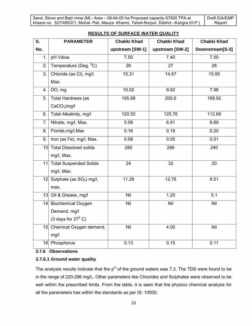
Sand, Stone and Bajri mine (ML- Area – 08-64-00 ha Proposed capacity 67500 TPA at khasra no. 527/495/2/1, Mohal- Pail, Mauza -Khanni, Tehsil-Nurpur, District –Kangra (H.P.)
Draft EIA/EMP Report
33
RESULTS OF SURFACE WATER QUALITY
S. No.
PARAMETER
Chakki Khad upstream [SW-1]
Chakki Khad upstream [SW-2]
Chakki Khad Downstream[S-3]
1. pH Value 7.50 7.40 7.50
2. Temperature (Deg. 0C) 26 27 28
3. Chloride (as Cl), mg/l,
Max.
15.31 14.67 15.95
4. DO, mg 10.02 9.92 7.98
5. Total Hardness (as
CaCO3)mg/l
195.88 200.6 169.92
6. Total Alkalinity, mg/l 120.52 125.76 112.66
7. Nitrate, mg/l, Max. 5.08 6.91 8.89
8. Floride,mg/l,Max 0.16 0.18 0.20
9. Iron (as Fe), mg/l, Max. 0.08 0.05 0.01
10. Total Dissolved solids
mg/l, Max.
280 288 240
11. Total Suspended Solids
mg/l, Max.
24 32 20
12. Sulphate (as SO4) mg/l,
max.
11.28 12.76 8.51
13. Oil & Grease, mg/l Nil 1.20 5.1
14. Biochemical Oxygen
Demand, mg/l
(3 days for 270 C)
Nil Nil Nil
15. Chemical Oxygen demand,
mg/l
Nil 4.00 Nil
16. Phosphorus 0.13 0.15 0.11
3.7.6 Observations 3.7.6.1 Ground water quality
The analysis results indicate that the pH of the ground waters was 7.3. The TDS were found to be
in the range of 220-286 mg/L. Other parameters like Chlorides and Sulphates were observed to be
well within the prescribed limits. From the table, it is seen that the physico chemical analysis for
all the parameters has within the standards as per IS: 10500.

Sand, Stone and Bajri mine (ML- Area – 08-64-00 ha Proposed capacity 67500 TPA at khasra no. 527/495/2/1, Mohal- Pail, Mauza -Khanni, Tehsil-Nurpur, District –Kangra (H.P.)
Draft EIA/EMP Report
34
3.7.6.2 Surface water Quality
The analysis results indicate that the pH of the surface waters was to be in the range of 7.40-7.50.
The TDS were found to be in the range of 240-288 mg/L. Other parameters like Chlorides and
Sulphates were observed to be well within the prescribed limits. From the table, it is seen that the
physico chemical analysis for all the parameters has within the standards as per IS: 10500.
3.8 Meteorology , The meteorological data helps for appropriate interpretation of the baseline status of the study
area as well as for input into prediction models to evaluate air quality dispersion. Chronological
data on meteorological parameters also plays an important role in identifying the general
meteorological regime of the region. The year may broadly be divided into three seasons:
• Winter season : October to Mid-March
• Summer Season : Mid-March to June
• Rainy season : July to September
3.8.1 Methodology
The methodology adopted for monitoring surface observations is as per the standard norms laid
down by Bureau of Indian Standards (IS: 8829) and India Meteorological Department (IMD).
Automatic Meteorological station has been installed near to the proposed project site.
3.8.2 Meteorological Data Recorded at Proposed Project Site
Meteorology plays a vital role in affecting the dispersion of pollutants. Since meteorological
factors show wide fluctuations with time, meaningful interpretations can be drawn only from long
term reliable data. The source of such data is the Indian meteorological Department (IMD), which
maintains a network of meteorological stations at several important locations.
3.8.3 Meteorological Data
The data recorded near mine site for the study period February-2012 to April-2012 are
summarized in Table 3.8.1, 3.8.2 and 3.8.3

Sand, Stone and Bajri mine (ML- Area – 08-64-00 ha Proposed capacity 67500 TPA at khasra no. 527/495/2/1, Mohal- Pail, Mauza -Khanni, Tehsil-Nurpur, District –Kangra (H.P.)
Draft EIA/EMP Report
35
TABLE-3.8.1 Meteorological data recorded at mine site in February-2012
Date Wind Direction(Deg) Temp(Deg C) R Humidity (%) Speed(Km/hr)
February-01 219 15.9 65 4.5
February-02 222 15.6 74 5.7
February-03 215 15.5 69 4.0
February-04 179 15.8 78 4.5
February-05 230 16.1 75 4.2
February-06 245 16.0 61 3.3
February-07 251 16.7 69 4.9
February-08 246 16.9 64 3.8
February-09 235 17.8 73 3.6
February-10 243 17.8 70 3.9
February-11 244 15.6 69 5.4
February-12 241 17.0 77 4.8
February-13 244 16.9 72 4.3
February-14 240 15.2 79 4.7
February-15 245 16.4 78 5.2
February-16 246 17.0 58 3.9
February-17 246 15.2 66 4.3
February-18 239 14.9 61 4.2
February-19 233 14.8 70 4.1
February-20 235 15.1 67 3.9
February-21 228 15.4 52 4.7
February-22 234 15.3 60 4.8
February-23 141 16.0 55 4.1

Sand, Stone and Bajri mine (ML- Area – 08-64-00 ha Proposed capacity 67500 TPA at khasra no. 527/495/2/1, Mohal- Pail, Mauza -Khanni, Tehsil-Nurpur, District –Kangra (H.P.)
Draft EIA/EMP Report
36
February-24 113 16.2 64 4.5
February-25 88 17.1 61 4.6
February-26 125 17.1 60 4.7
February-27 132 14.9 68 4.6
February-28 146 16.3 63 4.1
February-29 201 16.2 72 4.2

Sand, Stone and Bajri mine (ML- Area – 08-64-00 ha Proposed capacity 67500 TPA at khasra no. 527/495/2/1, Mohal- Pail, Mauza -Khanni, Tehsil-Nurpur, District –Kangra (H.P.)
Draft EIA/EMP Report
37
TABLE-3.8.2
Meteorological data recorded at mine site in March-2012 Date Wind Direction(Deg) Temp(Deg C) R Humidity (%) Speed(Km/hr)
March-01 203 20.2 61 5.0 March-02
203 18.7 58 3.0 March-03
203 19.6 61 4.3 March-04
202 20.0 61 3.5 March-05
199 20.3 60 4.6 March-06
204 21.4 59 4.2 March-07
204 22.9 57 4.3 March-08
205 23.6 56 3.5 March-09
203 24.2 57 4.2 March-10
238 24.1 62 4.3 March-11
241.3 25.4 58 4.2 March-12
220.4 21.4 56 4.3 March-13
242.1 21.6 47 4.2 March-14
239.5 21.2 52 4.3 March-15
241.4 22.3 51 3.3 March-16
246.4 23.0 49 5.0 March-17
232.2 21.5 48 5.0 March-18
189.2 23.9 52 4.3 March-19
198.9 24.7 52 3.6 March-20
198.5 21.7 58 3.8 March-21
200.8 23.7 40 4.6 March-22
204.2 21.5 50 4.7 March-23
201.7 21.8 49 4.9 March-24
198.9 22.8 47 4.1

Sand, Stone and Bajri mine (ML- Area – 08-64-00 ha Proposed capacity 67500 TPA at khasra no. 527/495/2/1, Mohal- Pail, Mauza -Khanni, Tehsil-Nurpur, District –Kangra (H.P.)
Draft EIA/EMP Report
38
March-25 203.7 21.8 51 3.2
March-26 203.0 23.8 43 3.1
March-27 204.0 23.8 42 5.0
March-28 141.5 23.6 47 5.2
March-29 152.2 19.8 61 5.9
March-30 139.5 18.5 44 5.0
March-31 195.6 21.65 36 4.2
TABLE-3.8.3 Meteorological data recorded at mine site in April-2012
Date Wind Direction(Deg) Temp(Deg C) R Humidity (%) Speed(Km/hr)
April-01 173.0 22.4 40 4.4
April-02 202.9 23.8 41 4.1
April-03 200.9 23.8 43 3.6
April-04 202.9 23.8 42 4.2
April-05 202.9 24.5 45 5.2
April-06 200.2 25.0 39 4.8
April-07 204.9 25.41 41 4.7
April-08 200.5 24.0 48 5.3
April-09 202.9 26.6 49 4.3
April-10 198.1 22.9 57 3.6
April-11 205.3 22.2 57 4.5
Apri-12 198.2 21.1 56 3.7
April-13 201.9 23.5 38 4.4
April-14 204.5 22.2 30 4.0
April-15 175.3 23.9 38 5.1
April-16 135.7 27.1 36 4.3
April-17 161.2 28.6 38 4.4

Sand, Stone and Bajri mine (ML- Area – 08-64-00 ha Proposed capacity 67500 TPA at khasra no. 527/495/2/1, Mohal- Pail, Mauza -Khanni, Tehsil-Nurpur, District –Kangra (H.P.)
Draft EIA/EMP Report
39
April-18 186.7 30.0 38 4.2
April19 177.6 29.1 40 4.5
April-20 192.3 30.6 42 4.8
April-21 241.0 31.2 40 4.0
April-22 168.2 31.6 34 4.6
April-23 178.6 28.6 44 4.7
April-24 192.0 21.6 69 4.9
April-25 212.7 24.0 69 4.2
April-26 191.0 24.8 68 4.9
April-27 213.1 21.8 52 4.5
April-28 157.2 23.8 46 4.3
April-29 182.1 21.6 52 4.9
April-30 222.6 22.3 48 3.7
Percentage frequencies of wind in 16 directions have been computed from the recorded data
during the study period [February, 2012 to April, 2012] for 24 hourly intervals to plot wind rose.
Fig – 3.8.1 represents the wind pattern of the study period.
3.8.4 Wind pattern during the study period The predominant wind direction during this period was from SE to NW. The wind rose diagram for
the study period is given below.

Sand, Stone and Bajri mine (ML- Area – 08-64-00 ha Proposed capacity 67500 TPA at khasra no. 527/495/2/1, Mohal- Pail, Mauza -Khanni, Tehsil-Nurpur, District –Kangra (H.P.)
Draft EIA/EMP Report
40
Figure - 3.8.1
Site specific Wind Rose Diagram
3.9 AMBIENT AIR ENVIRONMENT 3.9.1 AIR QUALITY
The ambient air quality with respect to the study zone of 10 km radius around the mine site forms
the baseline information. The various sources of air pollution in the region are dust rising from
unpaved roads, domestic fuel burning, vehicular traffic, agricultural activities, other industries, etc.
The prime objective of baseline air quality monitoring is to assess existing air quality of the area.
This will also be useful in assessing the conformity to standards of the ambient air quality as per
standards during the mine operations.

Sand, Stone and Bajri mine (ML- Area – 08-64-00 ha Proposed capacity 67500 TPA at khasra no. 527/495/2/1, Mohal- Pail, Mauza -Khanni, Tehsil-Nurpur, District –Kangra (H.P.)
Draft EIA/EMP Report
41
The baseline status of the ambient air quality has been assessed through scientifically designed
ambient air quality network. The design of monitoring network in the air quality surveillance
program has been based on the following considerations:
Meteorological conditions.
Topography of the study area.
Likely impact area.
3.9.2 AMBIENT AIR MONITORING
Ambient air monitoring was carried out on monthly basis in the surrounding areas of the mine site
to assess the ambient air quality at the source. To know the ambient air quality at a larger
distance i.e. in the study area of 10 km. radius, air quality survey has been conducted at 06
locations over a period of three months of February, March and April-2012. Major air pollutants
viz, Particulate Matter (PM10), Sulphur Dioxide (SO2), Nitrogen Dioxide (NO2), representing the
basic air pollutants in the region were identified for Ambient Air Quality Monitoring (AAQM). The
ambient air quality monitoring stations were set up at the following locations.
The prime objective of the baseline air monitoring was to evaluate the existing air quality of the
area. This will also be useful for assessing the conformity to standards of the ambient air quality
during the operation of the proposed mine.
This section describes the selection of sampling locations, methodology adopted for sampling,
analytical techniques and frequency of sampling. The results of monitoring carried out for study
period (February, March and April-2012) is presented in Table-3.9.4 to Table-3.9.5
3.9.3 Methodology adopted for Air Quality Survey
The baseline status of the air quality in the study area has been assessed through a scientifically
designed ambient air quality monitoring network. The design of monitoring network in the air quality
surveillance program has been based on the following considerations:
• Meteorological conditions on synoptic scale;
• Topography of the study area;
• Representatives of regional background air quality for obtaining baseline status; and
• Representatives of likely impact areas.
Ambient Air Quality Monitoring (AAQM) stations were set up at six locations with due consideration
to the above mentioned points. Table-3.9.1 gives the details of environmental setting around each
monitoring station and their distances with reference to the proposed mine. The AAQM locations
are depicted in Figure–3.9.1.

Sand, Stone and Bajri mine (ML- Area – 08-64-00 ha Proposed capacity 67500 TPA at khasra no. 527/495/2/1, Mohal- Pail, Mauza -Khanni, Tehsil-Nurpur, District –Kangra (H.P.)
Draft EIA/EMP Report
42
TABLE - 3.9.1 DETAILS OF AMBIENT AIR QUALITY MONITORING LOCATIONS
Station Codes
Location Distance from Mine [Km]
Direction
A-1 At Mine Site -- --
A-2 Baduni 3.7 NEE
A-3 Chakkar 4.1 NNW
A-4 Harial 1.8 NW
A-5 Ghandwal 2.1 S
A-6 Karoli 6.8 NW
FIGURE-3.9.1

Sand, Stone and Bajri mine (ML- Area – 08-64-00 ha Proposed capacity 67500 TPA at khasra no. 527/495/2/1, Mohal- Pail, Mauza -Khanni, Tehsil-Nurpur, District –Kangra (H.P.)
Draft EIA/EMP Report
43
AMBIENT AIR QUALITY SAMPLING LOCATIONS
3.9.4 Frequency and Parameters for Sampling Ambient air quality monitoring has been carried out with a frequency of two days per week at four
locations covering one complete season except monsoon (CPCB guidelines). The ambient air
quality parameters along with their frequency of sampling are given in Table-3.9.2.
TABLE-3.9.2 MONITORED PARAMETERS AND FREQUENCY OF SAMPLING
Parameters Sampling Frequency
Respirable Particulate Matter 24 hourly sample twice a week for a season except monsoon
Sulphur dioxide (SO2) 24 hourly sample twice a week for a season except monsoon
Oxides of Nitrogen (NOX) 24 hourly sample twice a week for a season except monsoon
3.9.5 Instruments used for Sampling
Respirable dust samplers (RDS) were used for monitoring of Respirable Particulate Matter
(RPM)/PM10 and gaseous pollutants like SO2 and NOx. .
3.9.6 Sampling and Analytical Techniques
Sampling and analysis was done as per guidelines issued by CPCB/MoEF. The techniques used
for ambient air quality monitoring and technical protocols are given in Table-3.9.3.
TABLE-3.9.3 TECHNIQUES USED FOR AMBIENT AIR QUALITY MONITORING
Sr. No.
Parameter Technique Technical Protocol
1. Respirable Particulate
Matter / PM 10
Respirable Dust Sampler
(Gravimetric method)
IS-5182 (Part-IV)
2. Sulphur Dioxide Modified West and Gaeke IS-5182 (Part-II)

Sand, Stone and Bajri mine (ML- Area – 08-64-00 ha Proposed capacity 67500 TPA at khasra no. 527/495/2/1, Mohal- Pail, Mauza -Khanni, Tehsil-Nurpur, District –Kangra (H.P.)
Draft EIA/EMP Report
44
3. Nitrogen Oxide Jacob & Hochheiser IS-5182 (Part-VI)
3.9.7 Presentation of Results
The analysis results for the study period are presented in detail in Table-3.9.4 and Table-3.9.5.Various statistical parameters like 98th percentile, average, maximum and minimum values
have been computed from the observed raw data for all the AAQ monitoring stations. The summary
of these results for all the locations is presented in Table-3.9.6. These are compared with the
standards prescribed by Central Pollution Control Board (CPCB).
TABLE-3.9.4 AMBIENT AIR QUALITY MONITORING RESULTS –A1,A2,A3
Location Mine Area (A1) Baduni (A2) Chakkar (A3)
Pollutant PM10 SO2 NOX PM10 SO2 NOX PM10 SO2 NOX Standard 100 80 80 100 80 80 100 80 80
01/02/12 35.6 4.6 12.6 36.9 4.6 10.6 36.2 4.3 9.9
03/02/12 30.4 4.1 13.2 31.6 5.2 12.4 39.9 4.1 12.1
08/02/12 32.5 5.2 11.2 30.8 4.8 13.1 40.1 4.6 10.5
10/02/12 37.5 4.3 10.9 33.9 4.2 10.1 35.2 5.0 13.1
15/02/12 31.9 4.9 12.3 36.1 5.1 9.8 34.8 4.2 10.1
17/02/12 36.9 4.1 13.5 39.6 4.2 7.9 32.9 4.9 9.5
22/02/12 42.8 4.2 14.2 34.8 4.2 9.8 33.8 5.1 8.6
24/02/12 33.3 4.8 10.3 30.1 5.2 8.3 39.2 5.5 8.4
29/02/12 37.8 5.1 10.9 39.8 4.9 10.3 34.5 5.0 10.3
02/03/12 46.2 4.6 12.3 43.9 5.6 12.0 30.9 4.3 12.5
07/03/12 35.4 5.2 11.8 40.3 5.1 9.3 38.5 4.6 10.4
09/03/12 39.9 4.8 13.2 36.4 4.6 8.3 41.2 4.9 9.8
14/03/12 42.6 4.4 10.2 35.9 4.1 12.3 36.2 5.2 8.3
16/03/12 46.8 4.9 11.2 40.3 4.0 10.1 32.4 4.5 10.1
21/03/12 40.8 5.2 09.3 32.1 4.6 11.8 36.9 4.9 10.3
23/03/12 31.6 4.1 10.1 36.4 4.2 9.4 39.2 5.3 9.6
28/03/12 37.2 4.3 08.9 30.8 4.3 12.3 37.6 4.4 8.6
30/03/12 37.8 5.1 10.9 33.5 4.5 10.1 42.1 4.9 11.1

Sand, Stone and Bajri mine (ML- Area – 08-64-00 ha Proposed capacity 67500 TPA at khasra no. 527/495/2/1, Mohal- Pail, Mauza -Khanni, Tehsil-Nurpur, District –Kangra (H.P.)
Draft EIA/EMP Report
45
04/04/12 33.9 4.8 9.3 32.4 4.0 8.6 35.4 4.0 10.3
06/04/12 29.4 4.1 8.3 38.6 4.2 9.9 39.2 4.8 12.4
11/04/12 31.6 5.2 10.6 36.1 4.9 10.8 36.4 5.1 9.8
13/04/12 28.9 4.6 13.2 30.3 4.3 12.1 40.2 4.5 8.6
18/04/12 33.5 4.2 10.8 34.2 5.1 10.4 38.9 4.9 10.6
20/04/12 39.4 5.1 09.4 28.4 4.4 11.3 35.3 5.3 9.1
25/04/1 32.6 5.5 11.1 29.8 4.0 12.1 39.7 4.2 12.1
27/06/12 33.1 4.6 10.7 35.6 4.9 10.9 42.1 4.1 10.3
Mean 36.1 4.7 11.2 34.9 4.6 10.5 37.3 4.7 10.2
Maximum 46.8 5.5 14.2 43.9 5.6 13.1 42.1 5.5 13.1
Minimum 28.9 4.1 8.3 28.4 4.0 7.9 30.9 4.0 8.3
98th percentile 46.2 5.2 13.5 40.3 5.2 12.4 41.2 5.3 12.5
TABLE-3.9.5
AMBIENT AIR QUALITY MONITORING RESULTS – A4,A5,A6 Location Harial (A4) Ghandwal(A5) karoli (A6)
Pollutant PM10 SO2 NOX PM10 SO2 NOX PM10 SO2 NOX Standard 100.0 80.0 80.0 100.0 80.0 80.0 100.0 80.0 80.0
02/02/12 52.3 5.6 15.6 46.8 5.3 12.3 41.5 5.2 10.3
04/02/12 58.1 6.7 14.1 40.3 4.6 10.2 47.9 4.4 11.9
09/02/12 49.6 6.2 16.6 42.5 4.1 10.8 45.2 4.9 09.5
11/02/12 55.3 5.5 11.9 48.1 4.9 11.3 50.5 4.1 12.6
16/02/12 50.2 5.1 12.1 50.6 5.2 12.3 51.2 5.9 11.9
18/02/12 46.4 6.8 13.5 44.2 5.6 13.5 53.9 5.2 15.2
23/02/12 49.9 6.2 14.2 49.9 4.6 12.1 52.8 5.5 12.1
25/02/12 52.1 5.3 16.9 53.6 4.0 10.6 55.1 4.6 10.4
01/03/12 56.3 5.9 13.2 55.6 4.8 10.6 44.8 5.5 12.1
03/03/12 51.4 6.3 15.3 47.3 5.3 8.9 49.2 5.1 10.6
08/03/12 50.8 6.0 14.1 49.5 4.5 9.2 41.5 4.7 12.9
10/03/12 46.2 4.3 15.5 53.6 4.1 10.6 45.2 4.1 10.1
15/03/12 48.9 5.2 13.3 49.8 5.2 8.6 44.6 5.2 11.2
17/03/12 52.7 5.0 16.2 56.2 5.6 9.8 48.9 4.1 12.5
22/03/12 55.3 4.5 14.1 51.3 5.0 10.6 50.3 4.9 13.2
24/03/12 49.2 6.9 15.9 45.3 4.4 12.5 55.2 4.8 11.5
29/03/12 45.9 5.3 16.3 50.6 4.8 10.9 51.5 4.3 12.6
31/03/12 48.2 5.7 14.1 54.5 5.1 11.7 48.6 5.2 13.2

Sand, Stone and Bajri mine (ML- Area – 08-64-00 ha Proposed capacity 67500 TPA at khasra no. 527/495/2/1, Mohal- Pail, Mauza -Khanni, Tehsil-Nurpur, District –Kangra (H.P.)
Draft EIA/EMP Report
46
05/04/12 51.2 5.9 12.9 48.6 5.0 12.6 44.9 5.5 11.6
07/04/12 46.5 6.2 15.5 52.3 4.8 10.8 51.2 4.6 12.3
12/04/12 44.8 5.1 14.1 49.6 4.1 13.5 52.5 5.1 13.2
14/04/12 49.6 5.0 12.3 44.2 4.6 14.2 45.2 4.8 12.5
19/04/12 47.8 4.5 11.5 50.3 4.9 11.0 50.8 4.2 12.1
21/04/12 53.2 5.1 12.3 47.5 5.3 10.3 47.1 4.9 11.5
26/04/1 46.7 5.2 11.9 49.6 5.6 12.6 51.2 5.5 10.2
28/04/12 49.9 5.8 13.5 45.1 5.1 11.1 46.5 4.9 11.9
Mean 50.3 5.6 14.1 49.1 4.9 11.3 49.0 4.9 12.0
Maximum 58.1 6.9 16.9 56.2 5.6 14.2 55.2 5.9 15.2
Minimum 44.8 4.3 11.5 40.3 4.0 8.6 41.5 4.1 9.5
98th percentile 56.5 6.8 16.6 55.6 5.3 13.5 55.1 5.5 13.2
Observations of the results Core Zone – Mine Area (A1) Respirable particulate matter (PM10) monitored in the Mine area showed 98th percentile value of
46.2 µg/m3
98th percentile values of Sulphur dioxide and Oxides of Nitrogen in the mine area from the
monitored data were 5.2 μg/m3 and 13.5 µg/m3 respectively.
Buffer Zone (Stations A2 to A6) Particulate Matter – PM10
PM10 values monitored at 5 locations showed 98th percentile values in the range of 40.3 – 55.6
µg/m3. Highest value of 55.6 µg/m3 was recorded at Ghandwal. However this value is well within
the limits of NAAQ.
Sulphurdioxide - SO2
98th percentile value of Sulphur dioxide in the study area from the monitored data was in the
range of 5.2 – 6.8 μg/m3. Maximum value of 6.8 μg/m3 was obtained near the sampling station
located at Harial village. The values of SO2 monitored in the study area are well within the limits
of NAAQ standards.
Oxides of Nitrogen - NOx
Ambient air quality status monitored for nitrogen oxides in the study area were in the range with
98th percentile values between 12.4 -16.9 μg/m3. A maximum value of 16.9 μg/m3 was prevailing
at the time of sampling at Harial village.

Sand, Stone and Bajri mine (ML- Area – 08-64-00 ha Proposed capacity 67500 TPA at khasra no. 527/495/2/1, Mohal- Pail, Mauza -Khanni, Tehsil-Nurpur, District –Kangra (H.P.)
Draft EIA/EMP Report
47
Results of the ambient air quality at all the above locations were found to be well within the limits
of National Ambient Air Quality (NAAQ) standards. Concentrations of, PM10, SO2 and NOx are
mainly contributed due to vehicular traffic and local activities.
Table 3.9.6 Summary of Ambient Air Quality Monitoring
Code Locations PM10 SO2 NOX
Max Min Max Min Max Min A-1 Mine Site 46.8 28.9 5.5 4.1 14.2 8.3 A-2 Baduni 43.9 28.4 5.6 4.0 13.1 7.9 A-3 Chakkar 42.1 30.9 5.5 4.0 13.1 8.3 A-4 Harial 43.2 33.5 5.6 4.2 16.9 11.5 A-5 Ghandwal 56.2 40.3 5.6 4.0 14.2 8.6 A-6 Karoli 55.2 41.5 5.9 4.1 15.2 9.5
Note: All values are represented in μg/m3
Table: 3.9.7 National Ambient Air Quality Standards
S. No.
Pollutant Time
Weighted Average
Concentration in Ambient Air
Method of Measurement
Industrial Area,
Residential Rural & Other
Areas
Ecologically Sensitive Area
(Notified by Central Govt.)
(1) (2) (3) (4) (5) (6)
1 Sulphur Dioxide
(SO2), μg/m3
Annual
Average *
24 hours **
50
80
20
80
1. Improved West and Gacke
Method.
2. Ultraviolet fluorescence
2
Oxides of
Nitrogen as NO2,
μg/m3
Annual
Average *
24 hours **
40
80
30
80
1. Modified Jacob & Hochheiser
(Na-Arsenite) Method
2. Chemiluminescence (Gas
phase)
3
Particulate Matter
(size less than
10μm) or PM10,
μg/m3
Annual
Average *
24 Hours **
60
100
60
100
1. Gravimetric,
2. TOEM,
3. Beta attenuation.

Sand, Stone and Bajri mine (ML- Area – 08-64-00 ha Proposed capacity 67500 TPA at khasra no. 527/495/2/1, Mohal- Pail, Mauza -Khanni, Tehsil-Nurpur, District –Kangra (H.P.)
Draft EIA/EMP Report
48
4
Particulate Matter
(size less than
2.5μm) or PM2.5,
μg/m3
Annual
Average*
24 Hours **
40
60
40
60
1. Gravimetric,
2. TOEM,
3. Beta attenuation.
5 Ozone (O3),
μg/m3
8 Hours **
1 Hours *
100
180
100
180
1. UV Photometric,
2. Chemilminescence,
3. Chemical Method.
6 Lead (Pb), μg/m3
Annual
Average *
24 Hours **
0.50
1.0
0.50
1.0
1. AAS/ICP Method after
sampling on EPM 2000 or
equivalent filter paper.
2. ED-XRF using Teflon filter
7
Carbon
Monoxide (CO),
mg/m3
8 Hours**
1 Hours
02
04
02
04
Non Depressive Infrared (NDIR)
Spectroscopy
8 Ammonia (NH3),
μg/m3
Annual
Average*
24 hours **
100
400
100
400
1. Chemiluminescence (Gas
phase)
2. Indophenol blue method
9 Benzene (C6H6),
μg/m3
Annual
Average* 05 05
1. Gas Chromatography based
continuous analyzer,
2. Adsorption and Desorption
followed by GC analysis.
10
Benzo(α) Pyrene
(BaP) –
Particulate Phase
only, ng/m3
Annual
Average* 01 01
Solvent extraction followed by
HPLC’GC analysis
11 Arsenic (As),
ng/m3
Annual
Average* 05 06
AAS/ICP Method after sampling
on EPM 2000 or equivalent filter
paper.
12 Nickel (Ni), ng/m3 Annual
Average* 20 20
AAS/ICP Method after sampling
on EPM 2000 or equivalent filter
paper.
* Annual arithmetic mean of minimum 104 measurements in a year at a particular site taken
twice a week 24 hourly at uniform intervals.

Sand, Stone and Bajri mine (ML- Area – 08-64-00 ha Proposed capacity 67500 TPA at khasra no. 527/495/2/1, Mohal- Pail, Mauza -Khanni, Tehsil-Nurpur, District –Kangra (H.P.)
Draft EIA/EMP Report
49
** 24 hourly or 08 hourly or 01 hourly monitored values, as applicable, shall be complied with
98% of the time in a year. 2% of the time, they may exceed the limits but not on two
consecutive days of monitoring.
Note: Whenever and wherever monitoring results on two consecutive days of monitoring exceed
the limits specified above for the respective category, it shall be considered adequate
reason to institute regular or continuous monitoring and investigation.
3.10 NOISE ENVIRONMENT
The physical description of sound concerns its loudness as a function of frequency. Noise in
general is sound, which is composed of many frequency components of various types of
loudness distributed over the audible frequency range. The most common and universally
accepted scale is the A weighted scale, which is measured as dB (A). This is more suitable for
audible range of 20 to 20,000 Hz. The scale has been designed to weigh various components of
noise according to the response of human ear. The environmental impact of noise can have
several effects varying from Noise Induced Hearing Loss (NIHL) to annoyance depending on
loudness of noise.
The main objective of noise monitoring in the study area is to establish the baseline noise levels
and assess the impact of the total noise expected to be generated during the project operations
around the project site.
3.10.1 Identification of Sampling Locations
A preliminary reconnaissance survey has been undertaken to identify the major noise generating
sources in the area. Noise at different noise generating sources has been identified based on the
residential, industrial and commercial activities in the area.
The noise monitoring has been conducted for determination of noise levels at three locations
covering both core and buffer zones in the study area. The noise levels at each location were
recorded for 24-hrs. The environment setting of each noise monitoring location is given in Table-3.10.1 and shown in Figure-3.10.1.
TABLE-3.10.1
DETAILS OF NOISE MONITORING LOCATIONS
Station Codes
Location Distance from Mine [Km]
Direction
N-1 Mine Site -- --

Sand, Stone and Bajri mine (ML- Area – 08-64-00 ha Proposed capacity 67500 TPA at khasra no. 527/495/2/1, Mohal- Pail, Mauza -Khanni, Tehsil-Nurpur, District –Kangra (H.P.)
Draft EIA/EMP Report
50
N-2 Harial 1.8 NW
N-3 Ghandwal 2.1 S
3.10.2 Method of Monitoring
Sound Pressure Levels (SPL) measurements were recorded at four locations. The readings were
taken for every hour for 24-hrs. The day noise levels have been monitored during 6 am to 10 pm
and night noise levels during 10 pm to 6 am at all the locations.
FIGURE-3.10.1 NOISE MONITORING LOCATIONS
Measured noise level displayed as a function of time provides a useful scheme for describing the
acoustical climate of a community. Noise levels recorded at each station are computed for
equivalent noise levels. Equivalent noise level is a single number descriptor for describing time

Sand, Stone and Bajri mine (ML- Area – 08-64-00 ha Proposed capacity 67500 TPA at khasra no. 527/495/2/1, Mohal- Pail, Mauza -Khanni, Tehsil-Nurpur, District –Kangra (H.P.)
Draft EIA/EMP Report
51
varying noise levels. The equivalent noise level is defined as mathematically
10Log1/T Σ (10Ln/10)
Where L = sound pressure level a function of time dB (A)
T = Time interval of observations
Noise levels during the night time generally drop, therefore to compute Equivalent noise levels for
the night time, noise levels are increased by 10 dB (A) as the night time high noise levels are
judged more annoying compared to the day time.
TABLE-3.10.2 RESULTS OF AMBIENT NOISE QUALITY MONITORING
Time N-1 Mine Site
N-2 Harial
N-3 Ghandwal
06am - 07am 42.8 45.6 43.9 07am - 08am 44.5 47.8 45.8 08am - 09am 48.9 50.1 48.6 09am - 10am 50.2 52.9 51.8 10am - 11am 52.6 54.3 53.5 11am - 12pm 50.3 53.2 52.9 12pm - 01pm 49.6 53.9 51.2 01pm - 02pm 48.9 51.1 49.8 02pm - 03pm 51.3 50.2 50.4 03pm - 04pm 51.9 49.9 50.9 04pm - 05pm 52.3 51.2 51.1 05pm - 06pm 52.8 52.6 52.6 06pm - 07pm 50.3 53.2 53.1 07pm - 08pm 48.6 50.1 50.6 08pm - 09pm 46.1 48.5 48.9 09pm - 10pm 45.2 46.9 48.1 10pm - 11pm 43.2 45.3 44.7 11pm - 12am 42.3 44.2 42.1 12am - 01am 40.1 43.1 40.3 01am - 02am 39.2 41.5 38.9 02am - 03am 38.4 40.2 38.2 03am - 04am 38.6 41.6 39.5 04am - 05am 39.3 42.1 39.9 05am - 06am 40.9 42.9 40.8
Max 52.8 54.3 53.5 Min 38.4 40.2 38.2
Leq Day dB(A) 50.0 51.4 50.8 Leq Night dB(A) 40.6 42.9 41.0
3.10.3 Presentation of Results

Sand, Stone and Bajri mine (ML- Area – 08-64-00 ha Proposed capacity 67500 TPA at khasra no. 527/495/2/1, Mohal- Pail, Mauza -Khanni, Tehsil-Nurpur, District –Kangra (H.P.)
Draft EIA/EMP Report
52
The statistical analysis is done for measured noise levels at three locations in the study area. The
parameters are analyzed for Lday and Lnight.The statistical analysis results are given in Table-3.10.3.
TABLE-3.10.3 STATISTICAL ANALYSIS RESULTS OF AMBIENT NOISE MONITORING
Location Noise Level dB (A)
Day Equivalent (Lday) Night Equivalent(Lnight)
Mine Site 50.0 40.6
Harial 51.4 42.9
Ghandwal 50.8 41.0
3.10.4 Observations of Results
a) Day time Noise Levels (Lday) The daytime (Lday) noise levels at all the locations are observed to be in the range of 50.0 dB (A) to
51.4 dB (A). The maximum noise level of 54.3 dB (A) was observed at Harial and the minimum
noise level of 38.2 dB (A) was observed at Ghandwal during the study period. It is observed that the
day time noise levels are in accordance to the prescribed limits.
b) Night time Noise Levels (Lnight) The nighttime (Lnight) noise levels at all the locations was observed to be in the range of 40.6 dB (A)
to 42.9 dB (A). The maximum noise level of 54.3 dB (A) was observed at Harial during the study
period. It is observed that the day time noise levels are in accordance to the prescribed limits.
The Ambient noise standards prescribed by Central Pollution Control Board (CPCB) for different
category of areas is given in the below table.
Table-3.10.4 Ambient Noise Quality Standards
Area Code Category of Area Limits In Leq. dB (A)
Day Time 06.00 am–10.00 pm
Night Time 10.00 pm–6.00 am

Sand, Stone and Bajri mine (ML- Area – 08-64-00 ha Proposed capacity 67500 TPA at khasra no. 527/495/2/1, Mohal- Pail, Mauza -Khanni, Tehsil-Nurpur, District –Kangra (H.P.)
Draft EIA/EMP Report
53
(A) Industrial Area 75 70 (B) Commercial Area 65 55 (C) Residential Area 55 45 (D) Silence Zone 50 40
1. Day Time is from 6.00 AM to 10.00 PM. 2: Night Time is reckoned between 10.00 PM to 6.00 AM 3. Silence Zone is defined as an area up to 100m around premises of Hospitals, Educational Institutions and Courts. Use of vehicle horn, loudspeaker and bursting of crackers is banned in these zones. Note: Mixed categories of areas be declared as one of the four above mentioned categories by the competent Authority and the corresponding standards shall apply Source: Central Pollution Control Board Norms
3.11 SOIL ENVIRONMENT 3.11.1 Soil Quality and Characteristics The information regarding soil environment has been collected from various secondary sources
and also through soil quality analysis of soil samples collected from the study area.
For studying soil quality of the region, three samples were collected to assess the existing soil
conditions in and around the project area. The soil sampling locations are presented in the below
Table-3.11.1. TABLE 3.11.1
SOIL SAMPLING LOCATIONS
Station Code Station Name Description Location with respect to site
Distance (Km) Direction
S-1 Mine Site Near Core Zone -- --
S-2 Ghandwal Near Agricultural Land 2.1 S
S-3 Harial Near Agricultural Land 1.8 NW
The present study on the soil quality establishes the baseline characteristics and identifies the
incremental concentrations if any, due to the proposed project. The objective of the sampling is:
• To determine the baseline soil characteristics of the study area;
• To determine the impact of proposed activity on soil characteristics; and
• To determine the impact on soils more importantly from agricultural productivity point of
view.
The soil sample was collected from three different depths viz. 30 cm, 60 cm and 90 cm. The
samples was then packed in a polythene plastic bag and sealed. The sample from three different

Sand, Stone and Bajri mine (ML- Area – 08-64-00 ha Proposed capacity 67500 TPA at khasra no. 527/495/2/1, Mohal- Pail, Mauza -Khanni, Tehsil-Nurpur, District –Kangra (H.P.)
Draft EIA/EMP Report
54
depths was homogenized and then was analyzed. The soil sampling locations are depicted in the
below figure.
FIGURE-3.11.1
SOIL SAMPLING LOCATIONS
3.11.2 Baseline Soil Status Soil quality of the study area is one of the important components of the environment. Soil
samples from villages located in the study area are collected as per methodology specified in BIS
to make them representative and analyzed for physico- chemical analysis. Samples are collected
by hand auger boring and soil pits.
The soil analysis results are presented in Table-3.11.2. The result obtained is compared with the
standard soil classification given in Table-3.11.3.

Sand, Stone and Bajri mine (ML- Area – 08-64-00 ha Proposed capacity 67500 TPA at khasra no. 527/495/2/1, Mohal- Pail, Mauza -Khanni, Tehsil-Nurpur, District –Kangra (H.P.)
Draft EIA/EMP Report
55
TABLE- 3.11.2
SOIL ANALYSIS RESULTS
S. No. Parameters Mine Site-S1 Ghandwal-S2 Harial-S3
1. Color Light brown Brown Black
2. pH Value 8.2 8.5 8.0
3. Water Holding Capacity % 37.2 35.7 30.5
4. Electrical Conductivity (Micro-
Siemens)
195 201 191
5. Organic matter % 1.5 1.7 2.1
7. Texture Course Loamy
Sand
Loamy Sand Loamy Sand
9. Nitrogen(N),gm/kg 1117.78 1097.49 1020.24
10. Phosphorous(P),gm/kg 0.037 0.025 0.024
11. Potassium(K),gm/kg 339.75 307.28 391.87
TABLE-3.11.3
STANDARD SOIL CLASSIFICATION
Sr. No. Soil Test Classification
1 PH <4.5 Extremely acidic
4.51- 5.00 Very strongly acidic
5.51-6.0 moderately acidic
6.01-6.50 slightly acidic
6.51-7.30 Neutral
7.31-7.80 slightly alkaline
7.81-8.50 moderately alkaline
8.51-9.0 strongly alkaline
9.01 very strongly alkaline
2 Salinity Electrical Conductivity
(mmhos/cm)
(1mmho/cm = 640 ppm)
Upto 1.00 Average
1.01-2.00 harmful to germination
2.01-3.00 harmful to crops

Sand, Stone and Bajri mine (ML- Area – 08-64-00 ha Proposed capacity 67500 TPA at khasra no. 527/495/2/1, Mohal- Pail, Mauza -Khanni, Tehsil-Nurpur, District –Kangra (H.P.)
Draft EIA/EMP Report
56
3 Organic Carbon (%) Upto 0.2: very less
0.21-0.4: less
0.41-0.5 medium,
0.51-0.8: on an average sufficient
0.81-1.00: sufficient
>1.0 more than sufficient
4 Nitrogen (Kg/ha) Upto 50 very less
51-100 less
101-150 good
151-300 Better
>300 sufficient
5 Phosphorus (Kg/ha) Upto 15 very less
16-30 less
31-50 medium,
51-65 on an average sufficient
66-80 sufficient
>80 more than sufficient
6 Potassium (Kg/ha) 0 -120 very less
120-180 less
181-240 medium
241-300 average
301-360 better
>360 more than sufficient
Source: ICAR (Indian Council for Agricultural Research)
Samples collected from identified locations indicate PH value ranging from 8.0 to 8.5, which
shows that the soil is alkaline in nature. Organic Matter ranges from 1.5 % to 2.1 % in the soil
samples.
3.12 Ecological Studies 3.12.1 Flora

Sand, Stone and Bajri mine (ML- Area – 08-64-00 ha Proposed capacity 67500 TPA at khasra no. 527/495/2/1, Mohal- Pail, Mauza -Khanni, Tehsil-Nurpur, District –Kangra (H.P.)
Draft EIA/EMP Report
57
Study of biological environment is one of the important aspects in Environmental Impact
Assessment in view of the need for conservation of Environmental quality. We were carried out
a detailed enumeration of species. Occurrences of flora at various locations were observed and
typical plant species were collected. The visual observations of plants were recorded with a view
to obtaining some idea about the relative density of certain species and their predominance.
Primary survey for flora and fauna studies have been conducted in and around proposed mine.
3.12.1.1 Objectives of Ecological Studies
The present study was undertaken with the following objectives:
• To assess the nature and distribution of vegetation in and around the project site;
• To assess the distribution of animal life spectra;
• To understand the productivity of the water bodies;
• To assess the biodiversity and to understand the resource potential; and
• To ascertain migratory routes of fauna and possibility of breeding grounds.
3.12.1.2 Methodology Adopted for the Survey
To achieve the above objectives a detailed study of the area was undertaken in 10 km radius
around proposed mine area. The different methods adopted were as follows:
• Generation of primary data by undertaking systematic ecological studies in the area;
• Discussion with local people so as to elicit information about local plants, animals and
their uses; and
• Gathering data for ethno biology.
The present report gives the review of published secondary data and the results of field sampling
conducted.
3.12.1.3 Terrestrial Ecological Status: Primary Survey
A preliminary survey was made and selected four locations for detailed study within 10-km radius.
The selected locations are given in Table- 3.12.1 and depicted in Figure-3.12.1.
TABLE-3.12.1 DETAILS OF ECOLOGICAL SAMPLING LOCATIONS

Sand, Stone and Bajri mine (ML- Area – 08-64-00 ha Proposed capacity 67500 TPA at khasra no. 527/495/2/1, Mohal- Pail, Mauza -Khanni, Tehsil-Nurpur, District –Kangra (H.P.)
Draft EIA/EMP Report
58
Location Code Name of village Distance (in km) Direction
EB-1 Karoli 4.8 NW
EB-2 Gagwal 2.4 SW
EB-3 Lodhwan 3.0 SE
EB-4 Malot 7.5 SSW
The primary data was generated through:-
1. Preparing a general checklist of all plants encountered in the study area. This would indicate
the diversity for wild and cultivated plants.
2. Determining the bird population of migratory and local birds by taking 10 random readings at
every Iocation; and
3. Observing mammals, amphibians and reptiles, noting their calls, droppings, burrows, pugmarks
and other signs.

Sand, Stone and Bajri mine (ML- Area – 08-64-00 ha Proposed capacity 67500 TPA at khasra no. 527/495/2/1, Mohal- Pail, Mauza -Khanni, Tehsil-Nurpur, District –Kangra (H.P.)
Draft EIA/EMP Report
59
Figure-3.12.1: Ecological Sampling Locations

Sand, Stone and Bajri mine (ML- Area – 08-64-00 ha Proposed capacity 67500 TPA at khasra no. 527/495/2/1, Mohal- Pail, Mauza -Khanni, Tehsil-Nurpur, District –Kangra (H.P.)
Draft EIA/EMP Report
60
3.12.1.4 Flora observed in study area The Chil is considered the prevailing conifer up to about 1950 meters when it gives place to the
Deodar and the blue pines.In Kangra district the forest range between scrub, sal and bamboo
forest of the low hills to the fur and alpine forests of the higher elevation. Lowest point of the
southern boundary of the district is less than 300 meters above sea level and highest range of is
at an elevation of 5500 meters in the north. The forests grown between these two extremes vary
as the elevation itself.
The most prominent varieties of trees found in the area are
• Simbal (Bombex malabaricum),
• Mango ( Magnifera indica)
• Tun (Cedrela toana)
• Several species of acacia and albizia
• Salambra (Odina wodier)
• Termnalia
• Jamun (Engenia jambolana)
• Larger tour
• Bamboo
Shrubs The most common shrub at the higher elevation is Barberis, indigopera and Desmodium and
following other shrubs are also found
• Vitex
• Munj
• Ber
• Ipomea
• Dodonea &
• Bamboo.

Sand, Stone and Bajri mine (ML- Area – 08-64-00 ha Proposed capacity 67500 TPA at khasra no. 527/495/2/1, Mohal- Pail, Mauza -Khanni, Tehsil-Nurpur, District –Kangra (H.P.)
Draft EIA/EMP Report
61
TABLE 3.12.2 FLORA IN THE STUDY AREA (CORE & BUFFER ZONE)
S. No. Botanical Name Common Name
1. Dalbergia sissoo Shisham
2. Azardiracta indica Neem
3. Albizzia lebbek Siris
4. Bauhinia variegata Kachnar
5. Bombax ceiba Semal
6. Eucalyptus tereticornis Eucalyptus
7. Ficus glomerata Gular
8. Ficus religiosa Pipal
9. Syzygium cumini Jamun
10 Cedrela tuna Tun
11. Cassia fistula Amaltas
12. Ficus bengalensis Bar
13. Cordia dichotoma Lassora
14. Acacia catechu Khair
15. Acacia arabica Kiker
16. Mallotus phillippinesis Kambel
17. Grewia oppositifolia Dhaman
18. Zizuphus mauratiana Ber
19. Pinus roxburghi Chil
20. Anogeissus latifolia Dhao
21. Diospyros cordifolia Kendu
22. Morus alba Tut
23. Acacia modesta Phulai
The crops grown in the study area
1. Triticum aestivum Wheat
2. Oryza sativa (Paddy)
3. Brassica Comoistris Mustard

Sand, Stone and Bajri mine (ML- Area – 08-64-00 ha Proposed capacity 67500 TPA at khasra no. 527/495/2/1, Mohal- Pail, Mauza -Khanni, Tehsil-Nurpur, District –Kangra (H.P.)
Draft EIA/EMP Report
62
4. Zea mays Corn
The vegetables grown in the study area
1. Brassica oleraces Cabbage
2. Solaunum melongena Brinjal
3. Capsicum annuum Chilli
4. Chaseolus vulgoris Bean
5. Lucopersicum esculentum Tomato
6. Spinacea oleracea Palak
7. Solanum tuberosum Potato
8. Cucumis sativus Cucumber etc.
Fruit trees grown in the study area:
1. Mangferra Indica Mango
2. Litchi chinensis Litchi
3. Citrus limon Lemon
4. Citrus spp. Orange
5. Eriobotrya japonica Loquat
3.12.2 Fauna in the Study Area Due to rich forest cover many fauna is expected to be found in this area .The wild lives present In
the study area mainly includes monkeys, Sambhar, rabbit, deer, fox, leopard etc. Domestic
animals include cow, buffalo, mules, hen, dogs, goat, oxen, cat are common.
Deer of many species including hiran ( Antilope cervicrapa), spotted deer ( Axis masculates),
Barking Deer (Muntiacus muntjak), kakkar, sambhar (Cervis unicolor) are common. Panthera
pardus (leopard): Its population has reduced considerably. Porcupine (Hystrix indica), Indian wild
boar (Sus scorfa), jackal (Canis spp.), wild cat (Felis chaos),leopard cat, Monkey (Macaca
mulata),Langur (Presbytis entellus).
3.12.2.1 Wild birds: The resident birds include peafowl black grey partridges and gooses, jungle
fowls, black partridges, chakor (Alectoris gracea), Jungle thrush, common grey quail, blue rock
pegion(Colombia livia), dove (streptopelis spp.),wood pecker and the migrants include variety of
water birds which can be often seen in Chakki khad in winters. Black eagle, Golden eagle,
shahin, falcons, Forest eagle, owl, parrot, jungle crow etc.

Sand, Stone and Bajri mine (ML- Area – 08-64-00 ha Proposed capacity 67500 TPA at khasra no. 527/495/2/1, Mohal- Pail, Mauza -Khanni, Tehsil-Nurpur, District –Kangra (H.P.)
Draft EIA/EMP Report
63
3.12.2.2 Reptiles: Snakes: Common Indian crait, Himalayan pit viper and other miscellaneous spp.
3.12.2.3 Aquatic fauna: Tortoise, Small fishes are found in Chakki Khad
Aquatic Micro invertebrate
Mollusca-Corbicula sp.,Lymnaeidae,Planorbidae
Annelida- Oligochaeta, glossiphonidae
Insecta- Coleoptera, Trichoptera.
TABLE 3.12.3 FAUNA IN THE STUDY AREA
S. No.
Zoological name Common Name Wildlife(Protection Act, 1972)
1. Felis chaos Jungle Cat Schedule-II
2. Cervus unicolor Sambhar Schedule-III
3. Passer domesticus House Sparrow Schedule-IV
4. Corvus spledens House Crow Schedule-V
5. Acridotherus tristicus Common Myna Schedule-IV
6. Herpestes spp. Newla Schedule-II
7. Vulpes bengalensis Fox Schedule-II
8. Macaca rhesus Monkey Schedule-II
9. Muntiacus muntjak Barking deer Schedule-III
10. Lepus nigricolis Rabbit Schedule-IV
11. Pavo cristatus Peacock Schedule-I
12. Strigidae spp. Owl Schedule-IV
13. Endybnamyes leucogaster Cheel Schedule-I
14. Psittacula krameri Parrot Schedule-IV
15. Viper russelli Viper Schedule-II
16. Python spp Ajgar Schedule-I
17. Panther pardus Panther Schedule-I
In addition to this Snakes, Lizards, Monkey, wild pig, porcupine are seen in the area. In core zone
rabbit and snakes are found commonly.

Sand, Stone and Bajri mine (ML- Area – 08-64-00 ha Proposed capacity 67500 TPA at khasra no. 527/495/2/1, Mohal- Pail, Mauza -Khanni, Tehsil-Nurpur, District –Kangra (H.P.)
Draft EIA/EMP Report
64
3.12.2.4 Animals
Due to wide variations in the attitude a large variety of fauna is available in the forests of the
district. The black bears are common in the higher valley. The leopards are found throughout the
district. Barking dears and gural are found at medium elevation the musk deer or Kastura and
serao are found in certain areas. Most commonly found is the porcupine, which is found in almost
in the entire District.
Common Mammals & Birds in the Kangra District is given in the Table-3.12.4
Table 3.12.4
Common mammals and birds in the Kangra District
Birds of District Kangra Zoological Name English Name Common Name
Milvus migrants Vulture Cheel, Gidh, Eell Eudynamys scolopacca Koel Koel Columbia livia Pigeon Kabuttar Coracias bengalensis Blue jay Nilkantha Colums livia Hawk Baj Francolius francolinus Black partridge Kala Tittar Francolius pondicerians Grey partridge Safed Tittar Payo crisslatus Peacock Mor Coturnix colurnix Common quail Bater Alectoris graeca Chakor Chakor Crovus splendens Crow Kanwa Prottacula Karneri Parrot Totta Lophophorus impejanus Monal Monal / Karadi Tertaogallus himalayanensis Snow cock Tragopan melanocephalus Western horned Tragopan Phulgar/Jujurana Picoides macei
Fulvourbreasted Pied Woodpecker
Kathfowra
Streptopelia decaocto Ring dove Gughi Streptopelia chinesis Spotted dove Gughi Accipiter badius Shikra Aquila rapax vindhian Tawny eagle Ducula bicolor Green Pigeon Parus rufonuchalis Tits Picus canus Black napped Woodpecker Woodpecker Drycocopus javensis Woodpecker Muscicapa subrubra Himalayan Fly Catcher

Sand, Stone and Bajri mine (ML- Area – 08-64-00 ha Proposed capacity 67500 TPA at khasra no. 527/495/2/1, Mohal- Pail, Mauza -Khanni, Tehsil-Nurpur, District –Kangra (H.P.)
Draft EIA/EMP Report
65
Acidotheres tristis Common Myna Ghatari Terpsiphone paradisi Paradise flycatcher Choti- Pinja Grus spp. Cranes Grus antigone Sarus Crane Saras Passer domesticus House sparrow Carduelis spinoides Himalayan Green Finch Chiria
In the leased out area and surrounding hills following are the common animals:-
• Leopard ( Bagher)
• Hare
• Wild Bore ( Jangli Soor)
• Jackal
• Barking Deer ( Kakkar)
• Monkey
• Sambar
• Pig
3.12.2.5 Birds
• Chakor
• Crow
• Red Jungle Fowl ( Jangli Murga)
• Black Partridge ( Kala Titar)
• Grey Partridge ( Safed Titar)
3.13 Socio-Economic Environment
The growth of industrial sectors and infrastructure developments in villages and towns is bound to
create its impact on the socio-economic aspects of the local population. The impacts may be
positive or negative depending upon the developmental activity. To assess the impacts on the
socio-economics of the local people, it is necessary to study the existing socio-economic status of
the local population, which will be helpful for making efforts to further improve the quality of life in
the area of study. To study the socio-economic aspects of people in the study area around
proposed mine, the required data has been collected from various secondary sources and
supplemented by the primary data generated through the process of a limited door to door socio-
economic survey.
3.13.1 Methodology Adopted for the Study

Sand, Stone and Bajri mine (ML- Area – 08-64-00 ha Proposed capacity 67500 TPA at khasra no. 527/495/2/1, Mohal- Pail, Mauza -Khanni, Tehsil-Nurpur, District –Kangra (H.P.)
Draft EIA/EMP Report
66
Review of secondary data, such as District Census Statistical Handbooks-2001 and the records of
National Informatics Center data, for the parameters of demography, occupational structure of
people within the general study area of 10 km radius around the project site.
3.13.2 Review of Demographic and Socio-Economic Profile - 2001
The information on socio-economic aspects of the study area has been compiled from secondary
sources, which include various public offices as indicated in the above section. The sociological
aspects of this study include human settlements, demography, social such as Scheduled castes
and Scheduled Tribes and literacy levels besides infrastructure facilities available in the study
area. The economic aspects include occupational structure of workers.
There are no villages falling within the core zone. The entire mine lease area is private lands and
falls under village Pail.
The requirement of unskilled semi skilled workers for the mining and transportation of minerals to
market and crushing site will be limited to about 18. The workers directly engaged for mining activity
will be deployed for collection of minerals and loading it into tractor trolleys/tipper trucks. About
four/five tractor trolleys/tipper trucks will be engaged daily as per demand. It is pertinent to mention
that percentage of marginal workers in the district is 18.85 and non worker is 56.01 percent as per
2001 census. Thus the project would give fruitful employment to local workers and will help in
stemming or at the least lessening the migration of such workers to urban centre from the village.
3.13.3 Occupational structure in buffer zone
In the initial stages, the shift of resources occurs away from the, primary sector (agriculture, forestry,
fishery, dairy, poultry, mining etc.) to the manufacturing sector or the secondary sector. These two
sectors are the commodity producing sectors and their activities are required to be supported by the
appropriate and adequate development of the service sector, or the tertiary sector.
Occupational structure of the workforce will be indicative of the economic activity. Any change in
occupational structure would be indicative of the changing nature economically. The occupational
structure has been worked out for categories of occupational available in the project buffer zone,
which includes cultivators, agricultural labor, and household industry workers etc.
3.13.4 Health Status

Sand, Stone and Bajri mine (ML- Area – 08-64-00 ha Proposed capacity 67500 TPA at khasra no. 527/495/2/1, Mohal- Pail, Mauza -Khanni, Tehsil-Nurpur, District –Kangra (H.P.)
Draft EIA/EMP Report
67
Health of the people is not only a desirable goal, but is also essential investment in human
resources. As per the National Health Policy (1983) primary health center has been accepted as a
main instrument for achieving this goal.
For the development and strengthening of rural health infrastructure through a three tier system,
such as sub centers, primary health centers (PHC) and community health centers have been
established.
3.13.5 Socio Economic Survey
Following salient observations were recorded:-
• Educational facilities are available in all the villages in the form of primary and middle
schools. In some of the villages it is extended up to high schools. For higher studies
people have to avail this facility from the nearest town.
• Primary health centers and sub-centers are available to the rural people. During
emergencies people have to move to the nearest town places.
• Communication facilities are available in the villages.
• Agriculture is the main occupation of the respondents. Main crops grown in the area are
wheat, maize, rice etc.
• Most of the villages having good infrastructural facilities like primary schools,
transportation, post office, telecommunication, power, banking facilities etc.
3.13.6 Awareness and opinion about the project
• The respondents from almost of all the villages are aware about this project activity.
• The respondents have mixed view about the project. Most of the respondents have opinion
that due to proposed project activity, economy of the villages will be improved.
• As regards the respondents from the nearby villages also shown favorable opinion about
activity that it may lead to increase in infrastructural facilities, job opportunities and business
opportunities in the project area.
• People from the villages under the study area have put their opinion and willingness for the
allotment of the land for the project.
3.13.7 Civic Amenities
Infrastructure resources are base of the villages with reference to education, drinking water
resources, post and telegraph, communications and supply.
• High school facility is available in the village Jasur (12Kms).

Sand, Stone and Bajri mine (ML- Area – 08-64-00 ha Proposed capacity 67500 TPA at khasra no. 527/495/2/1, Mohal- Pail, Mauza -Khanni, Tehsil-Nurpur, District –Kangra (H.P.)
Draft EIA/EMP Report
68
• Higher education facilities are available within 12 kilometers from mining lease area at
Pathankot.
• Banking facilities and Private medical practitioner are available at village Kandwal about 2
kilometres from Mining area.
• All Hospital /medical facilities and Banking facilities are available at Pathankot (12 kms) &
Nurpur (19kms).
• For drinking water, villages are dependent on ground water resource
• Most of the villages are connected through road network and are also approachable through
public transport.
• Electricity is available in all the villages.
3.13.8 Note on Agriculture Development and role of incoming project
The economy of Kangra district is predominately agrarian and majority of population is dependent
on agriculture and activities allied to it for earning their livelihood. The moisture retention capacity
of the area is poor due mainly to the fact the bed rocks are argillaceous and the land the uneven.
The crops usually face moisture stress during the remaining period of the year due to inadequate
and irregular rainfall. The irrigation facilities are provided by lifting water from steams, shallow dug
wells and medium to deep tube wells in the valley area.
Major food crops are grouped into three categories:
1. Cereals
2. Pulses
3. Other food crops like Chilies, ginger, sugarcane and turmeric.
Non- food crop area is of two kinds:
1. Oil seeds
2. Other non-food crops such as cotton, tobacco and fodder crop
Agriculture in this area plays vital role in the socio-economic development of the area as it
constitutes the main source of livelihood. Majority of the families in the periphery of 10Km radius of
the proposed project mainly depended on agriculture activity. Attention will be therefore focused on
this source of income while developing the projects in this area.
In this context following points may be noted:-
a. In a totally rain fed agriculture, the green revolution components can be appropriately used.
As a matter of fact irrigation is the basic inputs for the development of agriculture which
facilitate the use of inorganic fertilizers, insecticides and pesticides, improved seeds,

Sand, Stone and Bajri mine (ML- Area – 08-64-00 ha Proposed capacity 67500 TPA at khasra no. 527/495/2/1, Mohal- Pail, Mauza -Khanni, Tehsil-Nurpur, District –Kangra (H.P.)
Draft EIA/EMP Report
69
improved high yielding varieties of seed and use of modern agriculture implement and
mechanization to what extent possible by proper.
b. Farmers find it increasingly difficult to support their families’ entirely on agriculture and since
the avenues for employment outside agriculture are not developing fast enough, the
population pressure on land has kept on increasing all the time. Under these circumstances,
the farmers appear to be convinced:-
a. Agriculture is not likely to sustain them and their future generations.
b. Non-agricultural sources of employment are not likely to develop at fast rate enough to
accommodate and employ gainfully the subsequent additional force labors.
That such, if the present structure of economic activity in the project area were to continue
without any change, the farmers and their generation are likely to suffer untold hardship.

Sand, Stone and Bajri mine (ML- Area – 08-64-00 ha Proposed capacity 67500 TPA at khasra no. 527/495/2/1, Mohal- Pail, Mauza -Khanni, Tehsil-Nurpur, District –Kangra (H.P.)
Draft EIA/EMP Report
70
Table 3.13.1 Demography details of study area (5km buffer zone)
Name Pop
ulati
on
SC
Popula
tion'
Literate
s
Illiterat
es
Working
Populati
on
Main
Workers
Marginal
Workers
Non
Workers
Househ
olds
Literacy
Rate
Male
Population
Female
Populatio
n
Parnala 213 40 147 66 42 24 18 171 37 69.01 110 103Damin 101 0 75 26 58 15 43 43 17 74.26 47 54Padhar 233 0 167 66 35 35 0 198 45 71.67 108 125Songher 265 54 153 112 64 47 17 201 49 57.74 135 130Bhatoli 385 0 321 64 108 102 6 277 81 83.38 192 193Broti 74 0 47 27 16 16 0 58 11 63.51 33 41Haler 195 43 142 53 62 19 43 133 32 72.82 94 101Chhatwal 63 0 42 21 46 13 33 17 11 66.67 37 26Momun 790 107 508 282 311 191 120 479 153 64.30 386 404Suliali 1661 558 1268 393 300 202 98 1361 313 76.34 813 848Lodhwan 672 114 389 283 211 44 167 461 129 57.89 341 331Tipri 1179 272 724 455 338 250 88 841 213 61.41 647 532Gagwal 540 245 346 194 142 133 9 398 97 64.07 285 255Hagwal 748 92 505 243 187 183 4 561 124 67.51 393 355Padora 172 10 132 40 74 29 45 98 39 76.74 77 95Total 7291 1535 4966 2325 1994 1303 691 5297 1351 68.11 3698 3593
Source: Census-2001

Sand, Stone and Bajri mine (ML- Area – 08-64-00 ha Proposed capacity 67500 TPA at khasra no. 527/495/2/1, Mohal- Pail, Mauza -Khanni, Tehsil-Nurpur, District –Kangra (H.P.)
Draft EIA/EMP Report
71
3.14 Conclusion
The environment baseline study was conducted in the project area by both secondary data & primary
data collection. Abiotic factors including air, water and soil were studied for the core & buffer zone. It
was found that most of the parameters were within the limits as per the Indian Standards. In general,
there is no major threat to the quality of these parameters. Similarly, the study for the biotic factors
was conducted. It was found that no forests falls in the study area. Hence it can be concluded that the
present environment status of the study area is good enough for the enhancement of production
capacity. Adoption of adequate pollution control measures in past have shown that there is any
degradation in Quality of the environmental scenario of the area.

Sand, Stone and Bajri mine (ML- Area – 08-64-00 ha Proposed capacity 67500 TPA at khasra no. 527/495/2/1, Mohal-Pail, Mauza - Khanni, Tehsil Nurpur, District –Kangra(H.P)
DRAFT EIA/EMP REPORT
72
CHAPTER–IV ANTICIPATED ENVIRONMENTAL IMPACTS
AND MITIGATION MEASURES
4.1 ENVIORNMENTAL IMPACT ASSESSMENT
The environmental parameters likely to be affected by mining are related to many factors, i.e. physical, social, economic, agriculture and aesthetic. Opencast mining involves extraction of Sand Stone and Bajri and dumping of waste along with other operations, viz. traffic network, and other vehicular movements. All the operations can disturb environment of the area in various ways, such as removal of mass, change of landscape, displacement of human settlement, flora and fauna of the area, surface drainage, and change in air, water and soil quality. While for purpose of development and economic upliftment of people, there is need for establishment of industries and mining, but these have to be environmental friendly. Therefore, it is essential to assess the impacts of mining on different environmental parameters, before starting the mining operations, so that abatement measures could be planned in advance for eco-friendly mining in the area. The likely impacts on different environmental parameters due to this mining project are discussed below.
4.2 ENVIRONMENTAL IMPACT ASSESSMENT & MITIGATION MEASURES
The mining activities cause environmental problems such as degradation of land, deteriorating air, water and soil quality, affecting the biological and socio-economic environment of the area. The impacts of mining on various environmental parameters were assessed and are given below:
4.2.1 IMPACT ON AIR QUALITY & MITIGATION MEASURES 4.2.1.1 Impact of movement of vehicles for mineral transportation
Sand Stone and Bajri is transported from quarry to crusher located outside mining lease area by trucks/Tractor trolley and further leading to the crusher plant by vehicle after the proposed clearance.
4.2.2.2 Emission Rates
The emissions in the present case have been computed using empirical factor given in “Indian Mining and Engineering Journal”. The details of emissions computed from mining operations are given below: Total Sand, Stone & Bajri handling in the mine is 296 TPD on the bases of 270 working days per annum. Per hour handling of sand, stone & Bajri (on the bases of 08 hr/day operation) is 40 t/ hr. Total handling of material will be 40 t/hr. Rate of emission being 23.6 kg/ hr for handling 1000 t/ hr the emission rate shall be = 40 t/ hr X 23.6 kg/ hr = 0.944 kg/hr
1000 t / hr or 0.2622 gm/ sec
The above mentioned emission rates are uncontrolled emissions. Due to installation and operation of dust control measures at mining site, the emissions will be one third of established emissions. This is based on experience and literature. The emission rates and conditions have been summarized in Table-4.2.1.

Sand, Stone and Bajri mine (ML- Area – 08-64-00 ha Proposed capacity 67500 TPA at khasra no. 527/495/2/1, Mohal-Pail, Mauza - Khanni, Tehsil Nurpur, District –Kangra(H.P)
DRAFT EIA/EMP REPORT
73
TABLE-4.2.1 EMISSION RATE AND EMISSION CONDITIONS
MINE AREA STONE HANDLING
= =
8.6400 HECTARES 80000 TPA
DUST EMISSION RATE
=
0.2622 gm/ sec
EMISSION TEMPERATURE = AMBIENT
The emission rate concentration is too little hence; no Air modelling is required for the present project.
4.2.2.3 Ambient Air Quality Standards
Ambient air quality standards promulgated by National Ambient Air Quality Standards for different areas are as follows:
Area Time
Weighted Average
Concentration (μg/m3) PM10 SO2 NO2
Industrial Area, Residential Rural & Other Areas
Annual Average *
24 hours **
60 50 40 100 80 80
Ecologically Sensitive Area (Notified by Central Govt.)
Annual Average*
24 hours **
60 20 30 100 80 80
It is clear from the predicted values that the concentrations of SO2, NO2 and PM10 are well below the limits of NAAQS (Industrial Area, Residential Rural & Other Areas) at all locations. The increment in the fugitive emissions will be mainly due to transportation activity. Therefore emissions due to mineral handling during mining operation are not much and restricted to the lease area only. Proper mitigation measures are practiced during mining activities to control air pollution load below the prescribed limits. The same are as follows:
• Laying of haul roads as per the standards to avoid or eliminate air – borne dust. • Watering of haul roads and other roads at regular intervals • Spraying of water on permanent transport roads at required frequencies. • Provision of dust filters / mask to workers working at highly dust prone and affected
areas. • Provision of green belt by vegetation for trapping dust. • Greenbelt development along the haul roads, dumps and along the boundaries of the
lease area. • Utmost care will be taken to prevent spillage of sand and stone from the trucks.
4.2.2.4 Air Pollution Due To Mining
I. Gaseous Pollution
The gaseous pollutants (SO2 & NO2) are anticipated by transportation vehicles. The ambient air quality was measured on 24 hourly basis for the gaseous pollutants.
ii. Particulate Matter

Sand, Stone and Bajri mine (ML- Area – 08-64-00 ha Proposed capacity 67500 TPA at khasra no. 527/495/2/1, Mohal-Pail, Mauza - Khanni, Tehsil Nurpur, District –Kangra(H.P)
DRAFT EIA/EMP REPORT
74
The generation of dust is anticipated from various mining activities i.e. loading, haulage and other transport activities related to mining. These will increase PM10 in the area if no mitigative measures are taken.
4.2.2.5 Mitigation Measures for Air Pollution
In the stone mine, air pollution is caused mainly due to dust generation added with gaseous emission from mining activities like loading & transport etc. following measure shall be adopted to mitigate air pollution generated due to the mining activities:
4.2.2.6 Prevention and Control of Air Pollution
A. Dust Pollution One of the main pollutants in air will be particulate matter (PM), which will be generated during various activities of mining such as, removal of overburden, extraction of sand, stone and movement of vehicles. Following measures is been taken to minimize air pollution.
All the haul roads are properly graded with sufficient width and Water spray is been done on mine haul roads.
Green belt/plantation is been developed all along the haul roads and other places to arrest dust.
Personal Protective Equipments like dust mask is been provided to all employees working in the likely dusty areas.
Ambient Air Quality Monitoring is been conducted on regular basis to assess the quality of ambient air as per the EC conditions and submitted to respective authorities.
B. Prevention and control of Gaseous pollutants
Proper maintenance of vehicles is been done, which minimize the pollutants.
4. 3 IMPACT OF NOISE / VIBRATIONS & MITIGATION MEASURES 4.3.1 Impact of Noise on Working Environment
In the proposed mining operations noise levels due to excavation and transportation of Sand, Stone & Bajri. The area in general represents calm surroundings. There is no heavy traffic, industry or noisy habitation near the proposed leased mining area except stone crushers. As there will be no heavy earth moving machinery there will not be any major impact on noise level due to proposed mining and other associated activities. It was found that the proposed mining activity will not have any significant impact on the noise environment of the region. The only impact will be due to transportation of Bajri and stone by tractors to the stone crushing. To understand the combined effect of these noise levels on the nearby community, an attempt based on a scientific model has been made to estimate the noise levels at different distances from the proposed mine. The noise level at various locations due to different sources is calculated based on the following formula:
Lp2 = Lp1 – 20 log (r2 / r1) – Ae1, 2
Where, Lp1 and Lp2 are sound levels at points located at distance r1 / r2 from the source and Ae1,
2 is the excess attenuation due to environmental conditions. Combined effects from different sources at various locations are then computed by the following equation:
Lp (total) = 10 log (10 Lpx/10 + 10 Lpy/10 +10 Lpz/10 )
Where Lpx, Lpy, Lpz are noise pressure levels at a point due to different sources.
The predicted noise levels based on the above analysis in the nearby villages, considering that there is no attenuation on account of barriers, will be as follows:

Sand, Stone and Bajri mine (ML- Area – 08-64-00 ha Proposed capacity 67500 TPA at khasra no. 527/495/2/1, Mohal-Pail, Mauza - Khanni, Tehsil Nurpur, District –Kangra(H.P)
DRAFT EIA/EMP REPORT
75
LOCATION MAX.EXISTING ADDITION PREDICTED MAX
Mine Site 52.8 19.7 67.2 Harial 51.3 13.8 52.2 Ghandwal 53.5 17.6 51.7
All values are in dB(A)
From the above, it is clearly seen that there will be no significant impact on the surrounding community due to noise from the mine.
Thus due to natural attenuation effects, by proper green belt development, design / maintenance of machines, etc., the impact on noise levels will be minimal.
4.3.2 Noise Abatement and Control
4.3.2.1 Mitigation Measures to Reduce Ambient Noise Levels
The following control measures are been adopted to keep the ambient noise levels well below the limits:
Plantation has been carried out along mining lease boundary and sides of haul roads, etc. The greenbelt minimizes propagation of noise.
In order to reduce the effect of noise pollution, ear plugs /earmuffs are provided to all employees.
Selections of equipments have been done which generate less noise. Confining the noise generating sources. Periodical noise level monitoring is carried out.
4.4 Impact on Water Environment & Mitigation Measures 4.4.1 Impact on Surface Water
There are no first order streams passing through the lease area. So, surface drainage is not be affected by mining. It is, therefore, apparent that there will be negligible impact of mining on the surface water regime.
4.4.2 Mitigation Measures for Water Environment & Water Conservation
Adequate control measures are adopted to check not only the wash-off from soil erosion but also uncontrolled flow of mine water. The measures adopted are as follows:
No wastewater is generated from the mining activities. The ground water in the mine area is not likely to be affected, as no toxic chemicals
are present in the rejects stacked.
4.4.3 Rain Water Harvesting The proposed mine is situated on the river bed of the Chakki khad.So, no rain water harvesting structure is proposed.
4.5 Biological Environment 4.5.1 Impact on Terrestrial Ecology

Sand, Stone and Bajri mine (ML- Area – 08-64-00 ha Proposed capacity 67500 TPA at khasra no. 527/495/2/1, Mohal-Pail, Mauza - Khanni, Tehsil Nurpur, District –Kangra(H.P)
DRAFT EIA/EMP REPORT
76
The proposed mine lease area is ‘gair mumkin Khad’’ falling in category “land not available for cultivation”. There is no forest land within the mine lease area. The forest area is far away from the mining area and will not be disturbed during proposed mining operations. There are no national parks, sanctuaries, notified biospheres, Tiger/Elephant Corridors, Birds migratory routes, etc. within 10 km radius.
4.5.2 Impact on Flora
No adverse impact is envisaged on the existing flora, as there will be no deforestation by mining operation. Plantation is been developed in the mining lease area and same will be done as per plantation programme. These activities help to improve the floral cover of the area. The greenery and plantation development will eventually attract micro fauna, birds etc in the area.
Assistance will be taken from local forest department in selection of species of plants so that green coverage could improve very fast. The varieties would include those plants, which are suitable in the area. ,
The dust is the only major pollutant which will be generated from different activities of mining. The effect of particulate matter on vegetation is in the form of incrustation, plugging of stomata, loss of chlorophyll and reduction of photosynthesis process. Disturbance in plant metabolism due to deposition of dust particles on foliar surfaces leads to reduction in plant growth. The atmospheric concentrations normally do not reach a level sufficient to induce acute injury.
A perusal of previous section reveals that the maximum incremental ground level concentrations for PM10 likely to be encountered in the mine operations are well within the NAAQM standards.
Moreover, progressive afforestation programme activity over a period of time in the core zone will create favourable conditions for fauna in the area and hence reversible impact is anticipated after presence of favourable condition.
4.5.2.1 Measures for Minimizing Impact on Flora
Green Belt Development The proposed green belt in the lease area will to be designed taking into consideration the availability of area as the efficacy of green belt in pollution control mainly depends on width of the green belt, distance from pollution sources, site of the habitat from working place and tree height & density. While considering the above aspects due care will be taken for selecting the suitable characteristics plant species as those fast growing and evergreen trees, trees with large leaf area, locally suitable plant species, those resistant to specific pollutant and those which would maintain the regional ecological balance, soil and hydrological conditions. At the conceptual stage the land will be used for green belt / plantation, which will improve biological scenario of the area. The plantation work for green belt development will be carried in consultation with a horticulturist which will help minimizing adverse impact on the flora found in the area.
4.5.3 Impact on Fauna
The mining lease area is in non-forest land where presence of fauna is very rare. No endangered species of fauna is found in and around lease area. As such, there will be no adverse impact of the mining activity on fauna around the mining lease area.
4.5.3.1 Measures for Minimizing Impact on Fauna
Following measures will be adopted to minimize the impact of mining on faunal environment of the area.

Sand, Stone and Bajri mine (ML- Area – 08-64-00 ha Proposed capacity 67500 TPA at khasra no. 527/495/2/1, Mohal-Pail, Mauza - Khanni, Tehsil Nurpur, District –Kangra(H.P)
DRAFT EIA/EMP REPORT
77
Measures is been taken to curb pollution due to air, water, land & noise environment. Greenery developed around mining lease area helps in creating habitats for local faunal
species and to create better environment for various fauna. The tree plantation is been developed and animal food value in buffer area and the area
not under active mining as well as other neighbouring areas have been developed which have created favourable conditions for wildlife.
Creating and developing awareness for nature and wildlife in the adjoining villages.
Impact on Aquatic Ecology
The proposed mining activity is on the Chakki Khad bed. Since the mining activity is on the bed away from the river flow, therefore there shall be no impact on the aquatic flora and fauna.
4.6 Impact on Soil and Land Use Pattern & Mitigation Measures
4.6.1 Impact of change of land use
The lease area is 8-64-00 ha, The mine lease area belongs to private individuals. So, at the end of the mine life the area shall be eventually put into agricultural use.
In the ML area, mining activity will be confined to the mineralized zone & proper pollution control measures will be adopted to restrict the pollution load within the active zone in order to prevent any negative impact on nearby crop fields.
4.7 Socio - Economic Environment :
Opening of proposed mine definitely provides the following series of positive impacts: • Direct employment for over 18 persons in the various mine activities. • Indirect employment in transport sector, offer of contract labourers. • Improvement in the general living standards and knowledge sharing. • The wage level and the living standard of the local and the migrated people will also
improve as a result of higher earnings. • Improvement in the economic growth in the region • Benefit to the State and the Central governments through financial revenues by way of
royalty, tax, duties, etc from this project directly and also indirectly. • Additional mineral availability for the region.
From the above it can be confidently concluded that the project activities in short and long terms are expected to enhance the economic growth and all kinds of facilities of the area which is industrially and economically backward and hence the Impact on socio- economic environment will be positive.
4.8 Impact on local transport/infrastructure
The traffic density on the surrounding roads of the mine site is very low and capable of handling of increased traffic. In the proposed mining, the production capacity is less and for transporting of excavated material, less number of vehicles are required. Hence, the local transport / infrastructure facilities are capable of handling the increased load due to mining activities.
4.9 Impact of cumulative mining in surrounding area:
There are about five numbers of mining leases in 10 kilometres buffer zone area of the mining lease. The mining of sand stone and Bajri is being carried out in accordance with the approved mining plans which are prepared keeping in view the sustainability of the area.
4.10 Impact on Civic Amenities

Sand, Stone and Bajri mine (ML- Area – 08-64-00 ha Proposed capacity 67500 TPA at khasra no. 527/495/2/1, Mohal-Pail, Mauza - Khanni, Tehsil Nurpur, District –Kangra(H.P)
DRAFT EIA/EMP REPORT
78
The impact of mining on the civic amenities will be substantial after the increase production capacity of the project. With improved transportation facilities there is always a scope for development. The communications facilities have increased and developed in the area and will also further develop in near future.
4.11 OCCUPATIONAL HEALTH & SAFETY
Healthy and safe working conditions are among the first expectations for sustainability, i.e. the expectation that risks in mining will not deprive workers of their livelihoods or of their quality of life. Occupational injuries and ill-health have huge social and economic implications for individuals, their families and their communities. They also have an adverse impact on the economy of the society as a whole.
Occupational accidents and health hazards can also affect public health and safety, and the environment. The effect on the health and safety of people, costs to the economy and impacts the environment. Efforts will be made to address occupational health and safety with broader social agenda for sustainable development.
Hazards, which are associated with poor engineering design, contribute to increased safety risks. Although health risks can be avoided by implementing controls at source in the work environment, designing such controls for mining environment presents considerable challenges because dust and noise are generated by mining itself. A range of control measures that act together to reduce exposure to such risks is therefore necessary. These could include methods for minimizing dust levels by reducing dust generation and methods for dilution, suppression, capture, and containment.
While significant uncertainties remain in controlling dust exposures and maintaining the effectiveness of controls, the use of appropriate personal protective equipment (PPE) is important.
Occupational health and safety (OHS) is a cross-disciplinary area concerned with protecting the safety, health and welfare of people engaged in work or employment. The goal of all occupational health and safety programs is to foster a safe work environment. Excessive dust, noise and vibration are the chief health hazards for the miners. Some examples of such hazards are:
• Exposure to dust and • Noise exposure; • Vehicular movements and blasting related issues. • Physical Hazards.
Exposure to Dust
Exposure to fine particulates is associated with work in most of the dust-generating stages notably from drilling and blasting, mineral handling, and transportation. Workers with long term exposure to fine particulate dust are at risk of pneumoconiosis, emphysema, bronchitis, and fibrosis. Methods to prevent and control exposure to dust include the following:
• Control of dust through water spraying, • Use of PPE, as appropriate (e.g. masks and respirators) to address residual exposures.
Physical hazards
Injuries during Project operation are typically related to slips and falls; contact with falling / moving objects; and lifting / over-exertion. Other injuries may occur due to contact with, or

Sand, Stone and Bajri mine (ML- Area – 08-64-00 ha Proposed capacity 67500 TPA at khasra no. 527/495/2/1, Mohal-Pail, Mauza - Khanni, Tehsil Nurpur, District –Kangra(H.P)
DRAFT EIA/EMP REPORT
79
capture in, moving machinery (e.g. trucks). In case of any accident immediate & proper first –aid medical care is been provided at the mine site. Pre-placement medical examination and periodical medical examination schedules
• The fresh employees when taken are thoroughly medically examined under initial medical examination and thereafter during continuation of employment; the periodic medical examination is being done suggested by DGMS.
So far following activities have been practised by M/s.Nandi Stone Crusher:
No of Employees Examined: 18 Frequency of Examination
More than 45 years – once in Three Year Less than 45 years – once in Five Year
*********

Sand, Stone and Bajri mine (ML- Area – 08-64-00 ha Proposed capacity 67500 TPA at khasra no. 527/495/2/1, Mohal - Pail, Mauza -Khanni, Tehsil Nurpur, District –Kangra, H.P.
Draft EIA/EMP Report
80
CHAPTER–V
ENVIRONMENTAL MONITORING PROGRAMME 5.1 Introduction
Regular monitoring of environmental parameters is of immense importance to assess the status of
environment during project operation. With the knowledge of baseline conditions, the monitoring
programme will serve as an indicator for any deterioration in environmental conditions due to
operation of the project, to enable taking up suitable mitigatory steps in time to safeguard the
environment. Monitoring is as important as that of control of pollution since the efficiency of control
measures can only be determined by monitoring.
Usually, as in the case of the study, an impact assessment study is carried over short period of time
and the data cannot bring out all variations induced by the natural or human activities. Therefore,
regular monitoring programme of the environmental parameters is essential to take into account the
changes in the environmental quality.
Post Project Monitoring is an essential part to check the impact of any project activity. Hence
monitoring of various environmental parameters will be carried out on a regular basis to ascertain
the following:
• State of Pollution within the project site and in its vicinity.
• Generate data for predictive or corrective purpose in respect of pollution.
• Examine the efficacy of pollution control system adopted at the site.
• To assess environmental impacts.
Monitoring will be carried out at the site as per the norms of CPCB.Environmental Monitoring
Programme will be conducted for various environmental components as per the conditions
stipulated in Environmental Clearance Letter to be issued by MOEF. Six monthly compliance report
will be submitted every year to Regional office, MoEF, Chandigarh on 1st of June & 1st of December.
5.2 Formation of EMC (Environmental Management Cell)
In order to maintain the environmental quality within the standards, regular monitoring of various
environmental components is necessary. A full-fledged environmental management cell (EMC) will
be established for environmental monitoring and control. The EMC team will take care of pollution
monitoring aspects and implementation of control measures.
5.2.1 Responsibilities of EMC
The responsibilities of the EMC include the following:
• Environmental monitoring of the surrounding area.
• Commissioning of pollution control equipment.

Sand, Stone and Bajri mine (ML- Area – 08-64-00 ha Proposed capacity 67500 TPA at khasra no. 527/495/2/1, Mohal - Pail, Mauza -Khanni, Tehsil Nurpur, District –Kangra, H.P.
Draft EIA/EMP Report
81
• Specification and regulation of maintenance schedules for pollution control equipment.
• Ensuring that standards of housekeeping in the mine are maintained.
• Developing the green belt.
• Ensuring Water use is minimized.
• Carrying out the Environmental Management Plan.
5.3 Measurement Methodologies 5.3.1 Instrument to be used
The following instruments will be used for data collection work in the monitoring schedule:
1. Respirable dust sampler.
2. Fine volume sampler
3. Water level indicator
4. Sound level meter model
5.3.2 Monitoring Programme
The post project monitoring will include details of any major/ minor impact in the core zone and area
within buffer zone in respect of the following parameters: -
• Micro - meteorological data
• Ambient air quality monitoring
• Noise level monitoring
• Water quality & level
• Soil monitoring
5.4 Environmental Monitoring and Reporting Procedure
Monitoring shall confirm that commitments are being met. This may take the form of direct
measurement and recording of quantitative information, such as amounts and concentrations of
discharges, emissions and wastes, for measurement against corporate or statutory standards,
consent limits or targets. It may also require measurement of ambient environmental quality in the
vicinity of a site using ecological/biological, physical and chemical indicators. Monitoring may
include socio-economic interaction, through local liaison activities or even assessment of
complaints.
The preventive approach to management may also require monitoring of process inputs, for
example, type and method used, resource consumption, equipment and pollution control
performance etc.
The key aims of monitoring are, first, to ensure that results/conditions are as forecast during the
planning stage, and where they are not, to pinpoint the cause and implement action to remedy the
situation. A second objective is to verify the evaluations made during the planning process, in
particular with risk and impact assessments and standard & target setting and to measure
Sand, Stone and Bajri mine (ML- Area – 08-64-00 ha Proposed capacity 67500 TPA at khasra no. 527/495/2/1, Mohal - Pail, Mauza -Khanni, Tehsil Nurpur, District –Kangra, H.P.
Draft EIA/EMP Report
82
operational and process efficiency. Monitoring will also be required to meet compliance with
statutory and corporate requirements. Finally, monitoring results provide the basis for auditing.
5.4.1 Objectives of Monitoring
The objectives of monitoring are to:
• Verify effectiveness of planning decisions;
• Measure effectiveness of operational procedures;
• Conform statutory and corporate compliance; and
• Identify unexpected changes.
5.5 Environmental Monitoring
The monitoring program can serve as an indicator for any deterioration in environmental conditions
due to operation of the mine, and helps in planning suitable mitigatory steps that could be taken in
time to safeguard the environment. Monitoring is as important as that of control of pollution since the
efficiency of control measures can only be determined by monitoring. The following routine
monitoring program will be implemented under the post-project monitoring as per CPCB guidelines.
During operation of mine, dust is the main pollutant which arises from different mining and stone
crusher activities
The following attributes which merit regular monitoring based on the environmental setting and
nature of project activities are listed below:
• Source emissions and ambient air quality
• Groundwater quality
• Soil quality
• Noise levels (occupationnel exposures and ambient noise levels);and
• Ecological preservation and afforestation.
The following routine monitoring programme as detailed in Table-5.5.1 shall be implemented at site.
Besides to this monitoring, the compliances to all environmental clearance conditions and regular
permits from SPCB/MoEF shall be monitored and reported periodically.
The monitoring of liked project i.e. Stone Crusher shall be carried out as per the norms of State
Pollution Control Board to meet the prescribed standards under EPA. The unit shall be required to
install the pollution control equipment as per consent conditions.

Sand, Stone and Bajri mine (ML- Area – 08-64-00 ha Proposed capacity 67500 TPA at khasra no. 527/495/2/1, Mohal - Pail, Mauza -Khanni, Tehsil Nurpur, District –Kangra, H.P.
Draft EIA/EMP Report
83
TABLE-5.5.1 ENVIRONMENTAL MONITORING DURING OPERATIONAL PHASE
Sr. No.
Potential Impact
Action to be Followed
Parameters for
Monitoring
Frequency of Monitoring
Location
1 Air Emissions Ambient air quality
within the premises
of the proposed unit
and nearby
habitations to be
monitored.
PM10, PM2.5,
SO2, NOx and
CO.
Half Yearly Near Mine
office, Near
Haulage
road
Exhaust from
vehicles to be
minimized by use of
fuel efficient vehicles
and well maintained
vehicles having PUC
certificate.
Vehicle logs
to be
maintained
Regularly Main gate
Vehicle trips to be
minimized to the
extent possible
Vehicle logs Daily records Main gate
2 Noise Noise generated
from various mining
operations and
stone crusher
Spot Noise
Level
recording;
Leq(night),
Leq(day),
Leq(dn)
Periodic
during
operation
phase
Main gate,
working zone
3 Wastewater
Discharge
No untreated
discharge to be
made to surface
water, groundwater
or soil.
No discharge
hoses in
vicinity of
watercourses.
Periodic
during
operation
phase
-

Sand, Stone and Bajri mine (ML- Area – 08-64-00 ha Proposed capacity 67500 TPA at khasra no. 527/495/2/1, Mohal - Pail, Mauza -Khanni, Tehsil Nurpur, District –Kangra, H.P.
Draft EIA/EMP Report
84
Sr. No.
Potential Impact
Action to be Followed
Parameters for
Monitoring
Frequency of Monitoring
Location
4 Drainage and
effluent
Management
Ensure drainage
system and specific
design measures
are working
effectively.
Design to
incorporate existing
drainage pattern and
avoid disturbing the
same.
Visual
inspection of
drainage and
records
thereof
Periodic
during
operation
phase
-
5 Water Quality
and Water
Levels
Monitoring used
water quality &
groundwater quality
and levels
Comprehensi
ve monitoring
as per IS
10500
Groundwater
level bgl
Periodic
during
operation
phase
9 Maintenance
of flora and
fauna
Vegetation,
greenbelt / green
cover development
No. of plants,
species
Periodic
during
operation
phase
-
10 Waste
Management
Implement waste
management plan
that identifies and
characterizes every
waste arising
associated with
proposed activities
and which identifies
the procedures for
collection, handling
& disposal of each
waste arising.
Records of
solid waste
generation,
treatment and
disposal
Periodic
during
operation
phase
11 Soil quality Maintenance of Physico- Periodical Plantation

Sand, Stone and Bajri mine (ML- Area – 08-64-00 ha Proposed capacity 67500 TPA at khasra no. 527/495/2/1, Mohal - Pail, Mauza -Khanni, Tehsil Nurpur, District –Kangra, H.P.
Draft EIA/EMP Report
85
Sr. No.
Potential Impact
Action to be Followed
Parameters for
Monitoring
Frequency of Monitoring
Location
good soil quality chemical
parameters
and metals.
monitoring areas
12 Health Employees and
migrant labour
health check ups
All relevant
parameters
including HIV
Regular
check ups
-
5.6 Monitoring Methods
5.6.1 Air Quality Monitoring
5.6.1.1 Workspace Monitoring
The concentration of air borne pollutants in the workspace/work zone environment shall be
monitored periodically. If concentrations higher than threshold limit values are observed, the source
of fugitive emissions shall be identified and necessary measures taken. If the levels are high
suitable measures as detailed in EMP shall be initiated.
5.6.1.2 Ambient Air Quality Monitoring
The ground level concentrations of PM2.5,PM10, SO2 and NOX in the ambient air shall be monitored
at regular intervals. Any abnormal rise shall be investigated to identify the causes and appropriate
action shall be initiated. Greenbelt shall be developed for minimising dust propagation.
5.6.2 Water Quality Monitoring
Periodic water audits shall be conducted to explore further possibilities for water conservation.
Methods prescribed in "Standard Methods for Examination of Water and Wastewater" prepared and
published jointly by American Public Health Association (APHA), American Water Works
Association (AWWA) are recommended.
5.6.2.1 Groundwater
The monitoring of groundwater is the most important tool to test the efficiency of mining
performance. It is suggested to collect water samples nearer to mine site and analyse. Records of
analysis should be maintained.
5.6.2.2 Surface Water Nearest surface water source is Chakki Khad. It is suggested to collect surface water samples from
upstream and downstream directions to assess the quality of the water.Records of analysis should
be maintained

Sand, Stone and Bajri mine (ML- Area – 08-64-00 ha Proposed capacity 67500 TPA at khasra no. 527/495/2/1, Mohal - Pail, Mauza -Khanni, Tehsil Nurpur, District –Kangra, H.P.
Draft EIA/EMP Report
86
5.6.3 Noise Levels
Noise levels shall be monitored in the mine area. The noise monitoring shall be conducted in regular
intervals at working zone and near main gate.
5.7 Reporting Schedules of the Monitoring Data
It is proposed that voluntary reporting of environmental performance with reference to the EMP
should be undertaken.
The environmental monitoring cell shall co-ordinate all monitoring programmes at site and data thus
generated shall be regularly furnished to the state regulatory agencies.
The frequency of reporting shall be on six monthly basis to the local state PCB officials and to
Regional office of MoEF. The Environmental Audit reports shall be prepared for the entire year of
operations and shall be regularly submitted to regulatory authorities.
5.8 Data Analysis
Monitoring data analysis will be done as per CPCB guidelines by EPA approved laboratory & shall
be submitted to concern authority (specified in Environment Clearance Letter issued by MoEF, &
Consent issued by HPSPCB) on regular basis.
5.9 Detailed Budget
Capital cost of the project is Rs. 5088000.00
Cost proposed for EMP measures is Rs. 3,500,00/=
Recurring Cost for EMP: Rs. 70000/ annum
*********

Sand, Stone and Bajri mine (ML- Area – 08-64-00 ha Proposed capacity 67500 TPA at khasra no. 527/495/2/1, Mohal Pail, Mauza- - Khanni, Tehsil Nurpur, District –Kangra, H.P.
Draft EIA/EMP Report
87
CHAPTER–VI
ADDITIONAL STUDIES
6.1 Introduction As per New EIA Notification dated 14.09.2006, the first technical presentation for TOR was held
on November 28-30, 2011 Terms of Reference (TOR) were issued from EAC (M), vide Letter No.
No.J-11015/213/2011-IA.II (M) dated 28th December, 2011.
6.2 Public Consultation
As per the New EIA Notification dated 14th September, 2006, Public hearing for this project has
to be conducted in accordance with the procedure to obtain the Environmental Clearance.
6.3 Risk Assessment and Disaster Management Plan
Risk Assessment and Disaster Management Plan is prepared keeping in view that location of the
proposed project is close to the river. This plan is prepared based on the below considerations.
• The mining operations in the lease area would be confined to day light hours, from 9 A.M. to
5 P.M.
• The highest contour in the lease area is 437 meters above MSL
• The mining shall be restrained well above this level.
6.3.1 Definition
A major emergency in a work is one, which has the intensity to cause serious injury or loss of life.
It may cause extensive damage to property and serious disruption both inside and outside the
work. It would normally require the assistance of emergency services to handle it effectively.
Emergency may be caused by a number of different factors, it will normally manifest itself in two
basic forms, viz fire, explosion or toxic release.
6.3.2 Scope
An important element of mitigation is emergency planning i.e. recognizing that accidents are
possible, assessing the consequences of such accidents and deciding on the emergency
procedures, both on site and off site that would need to be implemented in the event of an
emergency. Emergency planning is just one aspect of safety and cannot be considered in
isolation.
6.3.3 Objective
The overall objectives of the emergency plan are:

Sand, Stone and Bajri mine (ML- Area – 08-64-00 ha Proposed capacity 67500 TPA at khasra no. 527/495/2/1, Mohal Pail, Mauza- - Khanni, Tehsil Nurpur, District –Kangra, H.P.
Draft EIA/EMP Report
88
(a) To localize the emergency and, if possible eliminate it; and
(b) To minimize the effect of the accident on people and property.
Elimination requires well planned process/technology and its effective implementation, so that
such situation should either not arises or if it comes, a pre warning is received for timely action in
built or by preparedness for zeroing the effects.
Minimizing the effects may include prompt action, rescue, first aid, and evacuation, fire fighting
and also passing on information promptly to people living nearby.
6.4 Disaster Management Plan
In order to handle disaster/emergency situations, an organizational chart entrusting responsibility
to various project personnel will be prepared with their specific roles during emergency.
6.5 Occupational Health and Safety
6.5.1 Occupational Health
Operation and Maintenance
Occupational health needs attention during operation phase. The problem of occupational health, in
the operation and maintenance phase is primarily due to dust and noise which could affect the
workers from respiratory and hearing problems. The necessary personal protective equipments will
be given to all the workers. The working personnel shall be given the following appropriate
personnel protective equipments.
Industrial Safety Helmet;
Zero power plain goggles with cut type filters on both ends;
Cylindrical type earplug;
Ear muffs;
Dust mask;
hand gloves;
Industrial safety shoes with steel toe.
All working personnel will be medically examined at least once in every year and at the end of his
term of employment. This is in addition to the pre-employment medical examination.
6.5.2 Safety Plan
Safety of both men and materials during operation phase is of concern. Safety plan shall be
prepared and implemented in the proposed site. The preparedness of an industry for the occurrence

Sand, Stone and Bajri mine (ML- Area – 08-64-00 ha Proposed capacity 67500 TPA at khasra no. 527/495/2/1, Mohal Pail, Mauza- - Khanni, Tehsil Nurpur, District –Kangra, H.P.
Draft EIA/EMP Report
89
of possible disasters is known as emergency plan.
Keeping in view the safety requirement during construction, operation and maintenance phases a
safety policy will be formulated with the following regulations:
• To allocate sufficient resources to maintain safe and healthy conditions of work;
• To ensure that adequate safety instructions are given to all employees;
• To provide wherever necessary protective equipment, safety appliances and clothing and to
ensure their proper use;
• To inform employees about materials, equipment or processes used in their work which are
known to be potentially hazardous to health or safety;
• To keep all operations and methods of work under regular review for making necessary
changes from the point of view of safety in the light of experience and up to date knowledge;
• To provide appropriate facilities for first aid and prompt treatment of injuries and illness at
work;
• To provide appropriate instruction, training, retraining and supervision to employees in health
and safety, first aid and to ensure that adequate publicity is given to these matters;
• To organize collection, analysis and presentation of data on accident, sickness and incident
involving people injury or injury to health with a view to taking corrective, remedial and
preventive action;
• To publish/notify regulations, instructions and notices in the common language of
employees;
• To prepare separate safety rules for each type of occupation/processes involved in at site;
6.5.3 Safety Organization
A qualified and experienced safety officer shall be appointed. The responsibilities of the safety
officer include identification of the hazardous conditions and unsafe acts of workers and advice on
corrective actions, conduct safety audit, organize training programs and provide professional expert
advice on various issues related to occupational safety and health. He is also responsible to ensure
compliance of Safety Rules/ Statutory Provisions.
6.5.4 Health and Safety Monitoring Plan
The health of all employees shall be monitored once in a year for early detection of any ailment due
to exposure to dust, heat and noise.

Sand, Stone and Bajri mine (ML- Area – 08-64-00 ha Proposed capacity 67500 TPA at khasra no. 527/495/2/1, Mohal Pail, Mauza- - Khanni, Tehsil Nurpur, District –Kangra, H.P.
Draft EIA/EMP Report
90
6.6 Natural Resource Conservation
• A green belt will be developed so that minimum soil erosion takes place.
• In any case the natural habitats of the existing flora and fauna will not be disturbed.
• Use of traditional knowledge in all aspects of conservation;
• Time to time analysis of the soil, water resources etc will be done in order to analyze the
negative impacts of mining activities on the environment.
6.7 R & R Action Plan
There will be no resettlement or rehabilitation issues involved in this project.
6.8 Corporate Social Responsibilities (CSR)
It is proposed to take up the CSR activities in line with the findings of socioeconomic survey
done.
The project proponent agrees to provide free of cost boulders, bajri and sand for social projects
as Panchayat ghar, schools in the area.
Employment - The Company will provide direct employment to around 18 skilled and semi
skilled persons and indirect employment to around 200 persons. The company will give
preference to local peoples.
6.9 IDENTIFICATION OF HAZARDS
The possibility of the following may be there for such projects:
(a) Fire associated with storage of combustible material, lubricants, oil.
(b) Accidents in the mine
To deal the above emergencies, the Emergency Plan is prepared.
6.9.1 Disaster Due To Surface Fire
The fire could be due to surface fire. Such case has so far not been reported. Likewise
equipment sometimes catches fire which needs to be dealt.
Code of Practice in Case of Fire at Mines
Objective:
To deal with fire efficiently and quickly at different locations of mine
Source of Fire:
i) Oil & Lubricant Room.
ii) Mine machineries.

Sand, Stone and Bajri mine (ML- Area – 08-64-00 ha Proposed capacity 67500 TPA at khasra no. 527/495/2/1, Mohal Pail, Mauza- - Khanni, Tehsil Nurpur, District –Kangra, H.P.
Draft EIA/EMP Report
91
Line of Action: i) Sufficient fire extinguishers will be installed at selected locations on site. Besides,
numbers of water hydrants with sufficient length of hosepipes will be made available at
the surface for fire protection.
ii) Any person notices any sign of fire shall immediately take steps to give warning by
blowing the siren continuously and take steps to extinguish the fire by using appliances
available near the site.
iii) Duties of mine Official: - The Mine officials receiving the warning will forthwith inform at
following places.
a) Fire fighting station
b) Mines Manager
c) Mines Agent / Owner
After intimation he should reach the spot, remove Men & Machinery and take steps to tackle the
fire in accordance with the fire fighting instructions. Inform the security office to get an
Ambulance if required.
a) Duties of Fire Fighting Team: - On receiving warning, the team shall reach the site of fire
and depending on its nature, class and extent shall take steps to extinguish it and rescue
persons who may be caught in fire.
b) Duties of Mines Manager: - (i) On receipt of information about fire, the Manager will forthwith rush to the spot and
assess the situation. He will oversee the overall rescue operation and make necessary
arrangement for medical aid to the affected persons, if any.
(ii) Inform the management and statutory bodies.
6.9.2 Code of Practice in case of Explosion & Accidents Objective To deal with accidents efficiently and quickly. Line of Action
Any person, who notices any explosion or accident, should immediately take steps to give warning by suitable mean and at the same time take necessary action for withdrawal of men from
the site He shall also inform the mine’s Manager and other officials without any delay. Duties of Mine’s Manager (a) On receipt of information about explosion or accident, the manager shall forthwith rush to
the spot and the situation. He shall make the arrangements for withdrawal of affected
persons, if any.
(b) Inform the hospital for Ambulance for affected persons, if any.
(c) Provide First aid to affected persons.
(d) Inform the senior officials and statutory bodies.

Sand, Stone and Bajri mine (ML- Area – 08-64-00 ha Proposed capacity 67500 TPA at khasra no. 527/495/2/1, Mohal Pail, Mauza- - Khanni, Tehsil Nurpur, District –Kangra, H.P.
Draft EIA/EMP Report
92
6.9.3 Action in Emergency
If any emergency like fire arises in the mine one should immediately inform to Security
Supervisor. Security will inform key personnel and act as detailed above and consequently
inform to CCR for broad announcement by Public Address System and to blow the Alarm if CCR
is not affected itself. The emergency alarm will be wailing sound for two minutes on hearing
telephone or alarm; the key personnel will act as per responsibilities. The procedure for all
emergency situations as mentioned above would be same.
6.9.4 Site Restoration
The incident controller will check the areas thoroughly for possible hazards such as toxic fume or
live wires after emergency and will inform site controller accordingly. The key personnel will meet
to evaluate their individuals and overall performance in responding to situation after the
emergency is over. The review shall determine.
Effectiveness of emergency response plan.
Mine crew performance.
Any need for updating or revision of the emergency response plan.
Suitable arrangement for restart of the work.
Evaluation and control of efficient arising out of mitigating measures like foam discharge
& overflow of oil in water.
Rehabilitate evacuated area.
Adopt measures to prevent similar recurrence.
6.9.5 Precautions
To avoid all these disasters at working place and to minimize their effects following precautions
shall be taken and arrangement shall be made at the working place.
(i) The persons shall be trained properly to handle the situation.
(ii) Detailed warning system, implementation procedure, emergency control centre, shall be
maintained at the mine with names of trained persons.
(iii) Details and availability of machinery, fire-fighting equipment shall be available at the site.
(iv) Proper arrangements shall be made for treatment of injured person, if any.
(v) All the safety equipment shall be available at the mine.
6.9.6 Post Disaster Analysis and Evaluation
When the emergency is over, the team will carry out a detailed analysis of cause of
accident/occurrence, evaluate the influence of various factors and find out the procedures to
minimize them in future. At the same time adequacy of disaster management plan shall be
evaluated and shortcomings shall be rectified to improve the plan.

Sand, Stone and Bajri mine (ML- Area – 08-64-00 ha Proposed capacity 67500 TPA at khasra no. 527/495/2/1, Mohal Pail, Mauza- - Khanni, Tehsil Nurpur, District –Kangra, H.P.
Draft EIA/EMP Report
93
6.9.7 Off-Site Emergency Planning Introduction
The off-site emergency plan is an integral part of any hazard control system. It would be based
on those accidents identified by the works management, which could affect people and the
environment outside the works. Thus, the off-site plan follows logically from the analysis that took
place to provide the basis for the on-site plan and the two plans should therefore complement
each other. The key feature of a good off-site emergency plan is flexibility in its application to
emergencies other than those specifically included in the formation of the plan. The roles of the
various parties that may be involved in the implementation of an off-site plan are described
below. The responsibility for the off-site plan will be likely to rest either with the works
management or with the local authority.
Either way, the plan must identify an emergency coordinating officer who would take overall
command of the off-site activities. As with the on-site plan, an emergency control center will be
required within which the emergency coordinating officer can operate. An early decision will be
required in many cases on the advice to be given to people living “within range” of the accident –
in particular whether they should be evacuated or told to go indoors. Consideration of evacuation
may include the following factors:
a. In the case of a major fire but without explosion risk (e.g. an oil storage tank), only houses
close to the fire are likely to need evacuation, although a severe smoke hazard may
require this to be reviewed periodically.
b. But if the fire is escalating it might be necessary to evacuate people nearby, but only if
there is time; if insufficient time exists, people would be advised to stay indoors and shield
themselves from the fire.
6.9.7.1 Aspects to Be Included In An Off-Site Emergency Plan
Some of the aspects to be included in off-site emergency plan are as follows:
a) Organization
Details of command structure, warning systems, implementation procedures, emergency control
centers Name and appointments of incident controller, site main controller, their deputies and
other key personnel.
c) Communications
Identification of personnel involved, communication center, call signs, network, list of telephone
numbers.

Sand, Stone and Bajri mine (ML- Area – 08-64-00 ha Proposed capacity 67500 TPA at khasra no. 527/495/2/1, Mohal Pail, Mauza- - Khanni, Tehsil Nurpur, District –Kangra, H.P.
Draft EIA/EMP Report
94
d) Voluntary Organizations
Details of organizers, telephone numbers, resources, etc
e) Humanitarian Arrangements
Transport, evacuation centers, emergency feeding, treatment of injured, first aid, ambulances.
f) Public Information
Arrangements for: -
(i) Dealing with the media-press office
(ii) Informing relatives, etc.
g) Assessment Arrangements for: -
(i) Collecting information on the causes of the emergency
(ii) Reviewing the efficiency and effectiveness of all aspects of the emergency plan.
6.9.7.2 Role of the Emergency Coordinating Officer
The various emergency services will be coordinated by an Emergency Coordinating Officer
(ECO) who is likely to be a senior police officer but, depending on the circumstances, could be a
senior fire officer. The ECO will liaise closely with the site main controller. Again depending on
local arrangements, for very severe incidents with major or prolonged off-site consequences, the
external control may pass to a senior local authority administrator or even an administrator
appointed by the Central or State Government.
6.9.7.3 Roles of Major Hazard Works Managements
Where the local authority has the organization to formulate the plan, the role of works
managements in off-site emergency planning will be to establish liaison with those preparing the
plans and to provide information appropriate to such plans. This will include a description of
possible on-site accidents with potential for off-site harm, together with their consequences and
an indication of the relative likelihood of the accidents.
Advice should be provided by works managements to all the outside organizations which may
become involved in handling the emergency off-site and which will need previously to have
familiarized themselves with some of the technical aspects of the works activities, e.g.
emergency services, medical departments, etc.
6.9.7.4 Role of The Local Authority
In some places the duty to prepare the off-site plan lies with the local authorities. They may have
appointed an emergency planning officer (EPO) to carry out all this duty as part of the EPO’s

Sand, Stone and Bajri mine (ML- Area – 08-64-00 ha Proposed capacity 67500 TPA at khasra no. 527/495/2/1, Mohal Pail, Mauza- - Khanni, Tehsil Nurpur, District –Kangra, H.P.
Draft EIA/EMP Report
95
roles in preparing for a whole range of different emergencies within the local authority area. The
EPO will need to liaise with the works to obtain the information to provide the basis for the plan.
Rehearsals for off-site plans are important for the same reasons as on-site plans and will need to
be organized by the EPO.
6.9.7.5 Role of the Police
The police normally assume the overall control of an emergency, with a senior officer designated
as emergency coordinating officer. Formal duties of the police during an emergency include
protecting life and property and controlling traffic movements. The functions include controlling
bystanders, evacuating the public, identifying the dead and dealing with casualties and informing
relatives of dead or injured.
6.9.7.6 Role of the Fire Authorities
The control of a fire is normally the responsibility of the senior fire brigade officer who would take
over the handling of the fire from the site incident controller on arrival at the site. The senior fire
brigade officer may also have a similar responsibility for other events. Fire authorities having
major hazard works in their area should have familiarized themselves with the location on site of
all stores of flammable materials, water and foam supply points and fire-fighting equipments.
6.9.7.7 Role of the Health Authorities
Health authorities, including doctors, surgeons, hospitals, ambulances and so on, have a vital
part to play following a major accident and they should form an integral part of any emergency
plan.
For major fires, injuries will be the result of the effects of thermal radiation to a varying degree
and the knowledge and experience to handle this in all, but extreme, cases may be generally
available in most hospitals.
6.9.7.8 Roles of the Government Safety Authority
The Inspectors of Director General of Mines Safety are likely to want to satisfy themselves that
the organization responsible for including the off-site plan has made adequate arrangements for
handling emergencies of all types including major emergencies.
In the event of an accident, local arrangements regarding the role of the factory inspector will
apply. In the aftermath, factory inspectors may wish to ensure that the affected areas are
rehabilitated safely. *********

Sand, Stone and Bajri mine (ML- Area – 08-64-00 ha Proposed capacity 67500 TPA at khasra no. 527/495/2/1, Mohal Pail, Mauza – Khanni, Tehsil Nurpur, District –Kangra, H.P.
Draft EIA/EMP Report
96
CHAPTER–VII
PROJECT BENEFITS
7.0 INTRODUCTION
As we know that the stone, sand and Bajri are the back bone of infrastructure development and
its demand is expected to increase further more in coming year to meeting demand of
infrastructure development. The proposed project would enable to meet a small part of the
growing demand in the state of Himachal Pradesh. Further, the proposed project will result in
improvement of upliftment of social structure in the area. The people residing in the nearby areas
will be benefited indirectly. It is anticipated that the proposed project will provide benefits for the
locals.
The company will help in overall socio economic development of the area. The company has
contributed substantially to the exchequer by way of royalty, excise and government taxes
7.1 DEMOGRAPHY BENEFITS
During the operational phase, about 18 people shall be employed. Considering that most of the
skilled/unskilled personnel proposed to be employed for the proposed project shall be from within
the study area, the proposed project would add to the population in the study area which results
in better scope for indirect employment etc. in addition to the workforce the indirect employment
also be generated for about 200 members or even more.
7.2 EDUCATION
Unskilled people and limited skilled people (depending on availability) shall be hired from local
population. Due to economic growth of these people there may be chances to growth of
education in that locality.
7.3 EMPLOYMENT
The man power requirements for the operational phase of the proposed project shall be about 18
persons. Many of these persons however shall be unskilled people and shall be satisfied from
local population.
In addition to the direct employment mentioned above, there will be indirect employment of local
people by utilizing their expertise in different areas like horticulture, site clearing, road
development, etc. Also, due to secondary development in the study area, employment
opportunities will be generated. About 50 or more people are expected to get indirect
employment. Preference shall be given to local populace based on their qualifications, skill set
and availability.
.
7.4 CONCLUSION

Sand, Stone and Bajri mine (ML- Area – 08-64-00 ha Proposed capacity 67500 TPA at khasra no. 527/495/2/1, Mohal Pail, Mauza – Khanni, Tehsil Nurpur, District –Kangra, H.P.
Draft EIA/EMP Report
97
M/s.Nandi Stone Crusher management have undertaken and will undertake various Socio
Economic upliftment activities .Development Projects are planned after a participatory need
assessment of the communities around the activity area. Each project has a one-year and a
three-year rolling plan, with milestones and measurable targets. The objective is to phase out the
presence over a period of time and then further hand over the reins of further development to the
people. This also enables the company to widen their reach.
The company also co-ordinates with the government bodies, district authorities, village
Panchayat and the end beneficiaries — the villagers. The Government has, in their 5-year plans,
special funds earmarked for human development and the company recourses to many of these.
At the same time, company also networks and collaborates with like-minded bilateral and
unilateral agencies to share ideas and ensure that efforts are not duplicated.
The management supports the local administration and other form of assistance for the
development of public facilities in the region. Mainly they are providing the basic amenities to
nearby villagers for water distribution, building of schools, hospitals, etc. and all this adds to the
economic positivity and benefits to the locals of the activity area.
In conclusion we may write that the Project Proponent proposes to enhance production of sand,
stone & Bajri from same lease area. There will be further generation of direct and indirect
employment due to this project. There will be increase in revenue generation to the government
by way of royalty, excise and government taxes. There will be further improvement in
infrastructure like education, roads, availability of drinking water, medical facilities in adjacent
villages. The increase in earnings of local villagers who will get employment in the limestone
mine and due to increased spending on social welfare measures by the company will provide
better standard of living for the villagers.
******

Sand, Stone and Bajri mine (ML- Area – 08-64-00 ha Proposed capacity 67500 TPA at khasra no. 527/495/2/1, Mohal Pail, Mauza – Khanni, Tehsil Nurpur, District –Kangra, H.P.
Draft EIA/EMP Report
98
CHAPTER–VIII
ENVIRONMENTAL MANAGEMENT PLAN
8.1 INTRODUCTION Utilisation of non-renewable resources of the study area and within the limits of permissible capacity.
The assimilative capacity of the study area is the maximum amount of pollution load that can be
discharged in the environment without affecting the designated use and is governed by dilution,
dispersion and removal due to physico-chemical and biological processes. The EMP is required to
ensure sustainable development in the study area of 10 Km radius of the proposed mining site; hence it
needs to be an all encompassive plan for the proposed activity. Government regulating agencies like
Pollution Control Board working in the region and more importantly the people living in the study area
need to extend their co-operation and contribution.
It has been evaluated that the study area has not been affected adversely with the proposed activity
and likely to get new economical fillip, not only for the study area but also for the region as a whole.
Mitigation measures at the source level and an overall management plan at the study area level are
elicited so as to improve the supportive capacity of the receiving bodies. The EMP aims at controlling
pollution at the source level to the possible extent with the available and affordable technology followed
by treatment before they are discharged.
Environmental management for the proposed mining activity is discussed for the environmental impact
pertains to the operational phase. Even though reversible in nature - all the impacts will be visible only
during operational phase. It is planned to take corrective measures to ensure that these effects are
kept to bare minimum. The EMP will therefore, be initiated during planning stage itself.
The environmental management plan consists of a set of mitigation, management, monitoring and
institutional measures to be taken during implementation and operation of the project, to eliminate
adverse environmental impacts or reduce them to acceptable levels. The present environmental
management plan addresses the components of environment which are likely to be affected by the
different operations in the mine.
The objectives of EMP are:
• Overall conservation of environment.
• Minimization of waste generation and pollution.
• Judicious use of natural resources and water.
• Safety, welfare and good health of the work men and populace.
• Ensure effective operation of all control measures.

Sand, Stone and Bajri mine (ML- Area – 08-64-00 ha Proposed capacity 67500 TPA at khasra no. 527/495/2/1, Mohal Pail, Mauza – Khanni, Tehsil Nurpur, District –Kangra, H.P.
Draft EIA/EMP Report
99
• Vigilance against probable disasters and accidents.
• Monitoring of cumulative and long time impacts.
• Ensure effective operation of all control measures.
Environmental Management Plan (EMP) aims at the preservation of ecological system by considering
in-built pollution abatement facilities at the proposed site. Some of the major criteria governing the
environmental measures will be adopted, and the same is described in ensuring paragraphs.
8.2 POLLUTION CONTROL MEASURES 8.2.1 Air Pollution Control
The proposed mining operations are not anticipated to raise the concentration of the pollutants beyond
prescribed limits. However, the following measures would be adopted to mitigate the pollution levels in
ambient air. Dust particles generated during various mining activities when become airborne lead to
increase in particulates level in the ambient air. The major source of dust generation is the transport of
material by trucks and tractor trolleys. Adequate control measures shall be taken during mining
operations as well as transportation of minerals. The following measures will be taken to mitigate the
fugitive dust from different operations.
8.2.2 Prevention and control of Dust Pollution
The main pollutant in air is Particulate Matter (PM10), which is generated due to various mining
activities. However, to reduce the impact of dust pollution the following steps are being taken during
various mining activities.
a. During loading operation No machinery shall be used in loading process. Loading will be done completely manual method.
b. During Transport operation All the haulage roads in the area are being kept wide, levelled, compacted and properly
maintained and water is sprayed regularly during the shift operation to prevent generation of
fugitive dust due to movement of vehicles.
c. Plantation work : In order to reduce spread of air pollution in the surroundings, green belt is being developed around
the mines office, mine approach road, along mine boundary, etc. to control dust pollution.
d. Monitoring of air pollution Periodic air quality survey is being carried out to monitor the quality and for timely corrective
actions.
e. Laying of haul roads as per the standards to avoid or eliminate air – borne dust.
f. Watering of haul roads and other roads at regular intervals

Sand, Stone and Bajri mine (ML- Area – 08-64-00 ha Proposed capacity 67500 TPA at khasra no. 527/495/2/1, Mohal Pail, Mauza – Khanni, Tehsil Nurpur, District –Kangra, H.P.
Draft EIA/EMP Report
100
g. Spraying of water on permanent transport roads at required frequencies.
h. Provision of dust filters / mask to workers working at highly dust prone and affected areas.
i. Provision of green belt by vegetation for trapping dust.
j. Greenbelt development along the haul roads, dump and along the boundaries of the lease
area.
k. Utmost care will be taken to prevent spillage of sand and stone from the trucks.
The extracted mineral should be transported from the mine to crusher and the end user by
adopting following measures so as to minimize dust emissions.
Speed of the vehicles should be maintained with in the prescribed limits.
Trucks should not be over loaded and should be maintained to the body level.
8.3 Noise Environment
As there will be no heavy earth moving machinery there will not be any major impact on noise level due
to sand mining and other association activities a detailed noise survey has been carried out and results
were cross referenced with standards and were found to be well within limits.
Blasting technique is not used for sand and stone lifting, hence no possibility of land vibration. It was
found that the proposed mining activity will not have any significant impact on the noise environment of
the region. The only impact will be due to transportation of sand and stone by trucks and tractor
trolleys.
The following control measures shall be taken to keep the ambient noise levels well within limits:
• Use of personal protective devices i.e., earmuffs and earplugs by workers, working in high noise
areas.
• The greenbelt with species of rich canopy around the lease area and along the roads will further
attenuate the noise levels.
• Conducting periodical medical check up of all workers for any noise related health problems
• Proper training to personnel to create awareness about adverse noise level effects.
• Planned noise monitoring at suitable locations in the mine and outside location for proper
effective remedial actions.
• Minimum use of horns and speed limit of 10 kmph
• Timely maintenance of vehicles and their silencers to minimize vibration and Sound.
• Care will be taken to produce minimum sound during sand and stone loading.
The greenbelt, which is being provided, will act as noise attenuator. With the noise abatement measures
(as indicated above), it is expected that the noise levels will be maintained in compliance with DGMS
standards.

Sand, Stone and Bajri mine (ML- Area – 08-64-00 ha Proposed capacity 67500 TPA at khasra no. 527/495/2/1, Mohal Pail, Mauza – Khanni, Tehsil Nurpur, District –Kangra, H.P.
Draft EIA/EMP Report
101
8.4 Water Environment 8.4.1 Surface Water
The major source of surface water pollution due to sand mining is insignificant, however the following
measures shall be undertaken to prevent water pollution.
• Utmost care will be taken to minimize spillage of stone and sand.
• Drainage around the mining area would be undertaken so that no rain water do not enter the
mining pits.
• Plantation will be under taken as per green belt development plan enclosed in approved mining
plan
8.4.2 Ground Water
There would not be any adverse effect on the ground water quality. The mineral formation does not
contain any harmful element, which could percolate into the ground and pollute the ground water.
Hence, no control measures are required. However, regular monitoring of quality in the existing hand pumps/tube wells in the vicinity would be
carried out both with reference to area and times intervals to study the hydrodynamics of the strata.
8.5 Land Environment
Any mining activity may alter the land use pattern in the lease area. In order to minimise the adverse
affects, the following suggestions have been made. Degradation of land is not a very significant adverse
impact of river bed mining due creation of access roads, mining operations, transportation of mined
material. In order to prevent the environmental degradation of leased mine area and its surroundings, the
following measures shall be taken;
• Minimal damage to the flora standing around the lease area.
• Operations during daylight only.
• No foreign material should be allowed to remain/spill in lease area and catchments area, or no
pits/pockets will be allowed to be filled with such material,
• No stockpiling of harvested sand and stone shall be done outside the lease area.
Movement of the vehicles on the road will be increased; however, non metalled road leading to sand
and stone mining area will be sprinkled with water at regular intervals. In addition to prevent spillage by
trucks/tractor trolley, over loading should be controlled along with speed limit.
There will be minimum numbers of access roads to lease area. No Access points to the lease area
shall be from the river bed side.
8.5.1 Plantation and Soil Conservation

Sand, Stone and Bajri mine (ML- Area – 08-64-00 ha Proposed capacity 67500 TPA at khasra no. 527/495/2/1, Mohal Pail, Mauza – Khanni, Tehsil Nurpur, District –Kangra, H.P.
Draft EIA/EMP Report
102
The main objective of the green belt is to provide a barrier between the source of pollution and the
surrounding areas. The green belt helps to capture the fugitive emission and to attenuate the noise
generated apart from improving the aesthetics. Development of green belt and other forms of greenery
shall also prevent soil erosion and washing away of topsoil besides helping in stabilizing the functional
ecosystem and further to make the climate more conducive and to restore water balance. While
making choice of plant species for cultivation in green belts, weightage has to be given priority to the
natural factor of bio-climate. It is also presumed that the selected plants will be grown as per normal
horticultural (or forestry) practice and authorities responsible for plantation will also make sure that
adequate provision for watering and protection of the saplings exists at site.
Soil Quality will be monitored on yearly basis in the area surrounding the core zone used for agricultural
activity to check for any negative impacts on the soil quality.
Year wise plantation activity shall be undertaken as proposed in the approved mining plan.
8.5.2 Post mining land use
As the mining lease area is part of old river bed and at a safe distance of about 100 meters from the
river bank, and it belong to private individuals, it would be converted into agricultural fields surrounded
by plantation undertaken during the mining period.
8.6 Biological Environment
The mining activity will have insignificant effect on the existing flora and fauna. Data have been
collected from various Government Departments such as forests, agriculture, fisheries, animal
husbandry and various offices to establish the pre project biological environmental conditions. The
project area is surrounded by reserved forests on the banks are also lined with agricultural land. The
purpose of the project itself is to convert the existing not cultivable land into land suitable for agriculture
and horticulture. It was found that the sand and stone mining activity will not have any significant impact
on the biological environment of the region.
8.6.1 Mitigation of Impacts on Biological Environment
There is a requirement to establish a stable ecosystem with both ecological and economic returns.
Minimization of soil erosion and dust pollution enhances the beauty of the core and the buffer zone. To
achieve this it is planned to increase plantation activities. The basic objectives of plantations are as
follows.
• Improvement of Soil quality
• Quick vegetative cover to check soil erosion
• Improvement in river bank stability

Sand, Stone and Bajri mine (ML- Area – 08-64-00 ha Proposed capacity 67500 TPA at khasra no. 527/495/2/1, Mohal Pail, Mauza – Khanni, Tehsil Nurpur, District –Kangra, H.P.
Draft EIA/EMP Report
103
• Conservation of biological diversity
8.7 OCCUPATIONAL HEALTH AND SAFETY MEASURES Occupational health and safety (OHS) is a cross-disciplinary area concerned with protecting the safety,
health and welfare of people engaged in work or employment. The goal of all occupational health and
safety programs is to foster a safe work environment.
To control and minimize the risks at workplace, Nandi Stone Crusher implements Health, Safety and
Environment Policy with the following objectives:
To prevent hazards
To provide safe and healthy environment to all the employees.
The company, therefore, adopts the policy set below for the purpose of creating and maintaining safe
and healthy environment.
8.7.1 Occupational health hazards at mine site:
Mining activity experiences risk of a number of hazards. Some examples of such hazards are as under:
• Exposure to dust
• Noise exposure;
• Physical Hazards;
• Vehicular movements and other related issues.
These mainly impact on those working within the mine although health hazards can also impact on local
communities.
8.7.2 Implementation of Occupational Health and Safety Measures
Occupational Health & Safety measures result in improving the conditions under which workers are
employed and work. It improves not only their physical efficiency, but also provides protection to their life
and limb. Management will consider the following safety measures:
• Safety clauses in contract order
• To depute dedicated safety team
• Inspection and maintenance of equipments and accessories
• Pre placement and periodic health check up
• Removal of unsafe conditions and prevention of unsafe acts
• Detailed analysis of each and every incident
• To provide standard PPEs and ensure its uses
• Periodic inspection by internal and external safety experts
• Celebrations of various safety events for awareness
• Medical facilities & first aid boxes will be established in the mine premises.

Sand, Stone and Bajri mine (ML- Area – 08-64-00 ha Proposed capacity 67500 TPA at khasra no. 527/495/2/1, Mohal Pail, Mauza – Khanni, Tehsil Nurpur, District –Kangra, H.P.
Draft EIA/EMP Report
104
Besides, following points are also taken care of during mine operation for assuring safety of workers:
Health Awareness Programmes and camps are organized and will be done in future too.
The mine workers are provided all necessary PPE, especially dust masks for their safe guard
from dust, Ear Plugs/Ear Muffs for noise and measures for other hazards. The fresh employees
when taken are thoroughly medically examined under initial medical examination and thereafter
during continuation of employment; the periodic medical examination will be conducted. The
examination includes apart from the general observation, the Chest X-ray, Lung function Test,
Spirometry, Auditory are conducted and the record of the same are maintained and submitted to
the concerned authorities.
Under initial vocational training, the workers are given training related to all safety and health
aspects pertaining to their vocation and thereafter every quarter, special training courses/
Awareness programme for Malaria eradication, HIV and health effects on exposure to mineral
dust are organized for employed person as well as for nearby villagers.
The Occupational Health Surveillance Programme: A team of qualified doctors and nurses
visit periodically for health check up of all the workers, team and its records is maintained
properly.
8.8 ENVIRONMENTAL MONITORING PROGREMME
Details of the Environmental Monitoring Programme have been incorporated in Chapter V
(Environmental Monitoring Programme) of this report.
8.9 Socio-Economic Environment /Corporate Social Responsibility
This project operation will provide livelihood to the poorest section of the society. The overall impact of
riverbed mining of sand stone and bajri on the social economics of the area shall be a very positive
one, as not only it will generate employment opportunities for local population at mine site but also in
associated activity i.e. at stone crushing plant , for transportation of mined material, etc . It will also
give a good boost to the general economy of the area.
About 18 persons shall be employed at mine site. And approximately 200 people are to be benefited
directly or indirectly by the project.
The project proponent as corporate social responsibility agrees to provide free of cost boulders, bajri
and sand for social projects as Panchayat ghar, schools in the area besides carrying out extensive tree
plantation.
The proposed mining activity is expected to provide stimulus to socio-economic activities in the region
and thereby accelerate further development processes.

Sand, Stone and Bajri mine (ML- Area – 08-64-00 ha Proposed capacity 67500 TPA at khasra no. 527/495/2/1, Mohal Pail, Mauza – Khanni, Tehsil Nurpur, District –Kangra, H.P.
Draft EIA/EMP Report
105
8.10 Cost Provision for Environmental Measures
It is proposed to invest a capital cost of Rs. 3.50 lakhs on pollution control, treatment and monitoring
systems with recurring amount of Rs.0.7 lakhs per annum. The break-up of the investment is given in
the following Table-8.7.1.
TABLE-8.7.1 COST PROVISION FOR ENVIRONMENTAL MEASURES
8.11 CONCLUSION As discussed, it is safe to say that the proposed project is not likely to cause any significant impact on
the ecology of the area, as adequate preventive measures has been adopted to contain the various
pollutants within permissible limits. Green belt development around the area is been developed and
also be taken up as an effective pollution mitigative technique, as well as to control the pollutants
released from the premises of Nandi Stone Crusher and will developed the greenbelt as per the
programme to improve aesthetic beauty of the area .
S. No Title Recurring Cost Rs. in Lakhs
Capital Cost Rs. in Lakhs
1. Monitoring of Air, Water ,Soil etc. 0.2 0.6
2. Air Pollution Control- Management of
Haulage Roads including Sprinkling
-- 0.8
3. Plantation and check dams as per Mining
plan
0.3 1.0
4. Disposal and spreading of Silt/clay as per
Mining Plan
-- 0.4
5. Occupational Health Measures Provision
of PPE and other Miscellaneous
expenditure
0.2 0.7
Total 0.7 3.5

Sand, Stone and Bajri mine (ML- Area – 08-64-00 ha Proposed capacity 67500 TPA at khasra no. 527/495/2/1, Mohal - Pail, Mauza - Khanni, Tehsil Nurpur, District –Kangra, H.P.
Draft EIA/EMP Report
106
CHAPTER–IX
SUMMARY AND CONCLUSION
9.1 INTRODUCTION
M/s.Nandi Stone Crusher, a partnership concern, with Sham Singh Mankotia and Parmod Singh as
partners, at village Pail, P.O. Khandwal, Tahsil Nurpur, District Kangra, Himachal Pradesh. The
mining lease was granted for mining of sand, stone and bajri vide letter No. Udhyog-Bhu (Khani-4)
Laghu – 502/09 - 6076 dated 13.09.2010 for a period of five year. The stone was used in a captive
stone crushing unit.
As per the New EIA Notification dated 14 September, 2006, the mining project falls under category
‘A’, project activity 1(a) (3).
9.2 JUSTIFICATION FOR THE PROJECT
The following points show the justification for the implementation of the proposed mining project:
The project involves mining / collection of about 68000 MTPA of sand, stone and bajri from
old river bed of Chakki Khad for a stone crushing unit to be set by the project proponent.
The total area of mine lease is 8-64-00 Hectares. The proponent has been granted mining
lease for mining of sand, stone and bajri for a period of five years for the extraction of sand,
stone & Bajri for use in already established stone crusher unit.
The project will generate employment for approx.18 persons during mine operation;
preference will be given to the local people.
There will not be any kind of major pollution due to the mining activity, as proper pollution
control measures will be implemented with environment friendly technology. There will be
“Zero Water Discharge”, as the domestic wastewater generated from the mine office will
be disposed off to soak pit via septic tank.
Water spraying on muck pile, Use of Murrum, Road Compactor & water spraying on haul
roads will be done.
Green belt will be developed as dust preventive barrier
No National Park, Biosphere Reserve, Wild Life Sanctuary, exists within the study area.

Sand, Stone and Bajri mine (ML- Area – 08-64-00 ha Proposed capacity 67500 TPA at khasra no. 527/495/2/1, Mohal - Pail, Mauza - Khanni, Tehsil Nurpur, District –Kangra, H.P.
Draft EIA/EMP Report
107
9.3 BRIEF DESCRIPTION OF THE PROJECT Table-9.3.1
Description of the Project S. No. Particulars Details
1. Lease Area Details
Total Lease Area (in hectares) 8-64-00 Ha.
2. Location Details Village Pail Tehsil & District Nurpur, Kangra Dist. State Himachal Pradesh Latitude 320 17’ 25.3” N to 320 17’ 40.7” N Longitude 750 46’ 31.2” E to 750 46’ 43” E Toposheet No. 43 P/15
Project Detail 3. Annual Turnover Rs. 50,88,000
4. Cost for Environmental Protection Capital Cost Rs. 3,500,00 Recurring Cost Rs. 700,00/ annum
Climatology (Post Monsoon Season: October to December, 2010)
5. A. Temperature Maximum : 43 0C Minimum : 22 0C
B. Relative Humidity At 8:30 hrs. At 17:30 hrs.
18 % to 68 % 18 % to 77 %
6. Dominant Wind Direction NW Project Site Vicinity Details
7. Nearest Village Pail 8. Nearest Railway Station Pathankot 9. Nearest National Highway N.H.-20 10. Nearest Airport Pathankot 11. Nearest city Pathankot 12. Nearest Water Body Chakki Khad 13. Place of Archaeological Importance Nil within the study area 14. Ecological Sensitive Areas Nil within the study area 15. Industries/Mines falling in 10 km radius
of the area Stone crusher units and Pharmaceutical industries
16. Seismic Zone Zone – V [as per IS 1893 (Part-I): 2002]
9.4 MINING DETAILS
Table – 9.4.1

Sand, Stone and Bajri mine (ML- Area – 08-64-00 ha Proposed capacity 67500 TPA at khasra no. 527/495/2/1, Mohal - Pail, Mauza - Khanni, Tehsil Nurpur, District –Kangra, H.P.
Draft EIA/EMP Report
108
Mining Details
S. No. Particulars Details
1. Method of mining Opencast, Manual Method
2. Mineable Reserve 160000 metric tons
3. Life of the Mine Deposit Replenish-able (Mine lease for 05
Years)
4. Ultimate Pit Slope angle 450
5. Elevation Range 433m – 437m
6. Ultimate Working Depth One metre from Bed level
7. Total waste generation till the end of
life of mine
50000 metric tonnes.
8. Stripping Ratio (mineral in tonnes to
over burden in m3)
5.0
9.5 MITIGATION MEASURES 9.5.1 Strategy to Control Air Pollution
The vehicles used for transportation are loaded as per their capacity.
All the haul roads are kept properly graded with sufficient width and regular water spraying is
done on the haul roads.
Personal Protective Equipments like dust masks, ear plugs/ear muffs, goggles, helmets, safety
shoes, hand gloves, etc. are provided to employees.
Proper maintenance (preventive as well as scheduled maintenance) of vehicles are carried out
regularly for minimization of generation of gaseous pollutants.
Development of green belt/plantation is being done around the lease boundary, sides of
approach roads and other places to arrest dust.
Periodic air quality monitoring is carried out.
9.5.2 Reclamation Plan for Land use
Total mining lease area is 8-64-00 hectare.
After the completion of mining in the ultimate pit at 345 metres level the area would be leveled as far
as possible. The entire silt and clay would be spread all over the area making it suitable for
agricultural and / or horticultural purpose, depending upon the preference of the land owners, it
being private land.
Post Mining Management Plan

Sand, Stone and Bajri mine (ML- Area – 08-64-00 ha Proposed capacity 67500 TPA at khasra no. 527/495/2/1, Mohal - Pail, Mauza - Khanni, Tehsil Nurpur, District –Kangra, H.P.
Draft EIA/EMP Report
109
In view of the fact that the land is privately owned and after mining it will revert back to the owners
and they will be putting it to best possible economic use of either agricultural and / or horticultural
purpose, no special ‘Post Mining Management Plan’ is envisaged.
Phase wise Green belt Development. During the period the area is used for mining purposes, plantation of the safety belt around lease
area will be undertaken. After the first year and subsequent years the plantation would be done in
the abandoned benches.
9.5.3 Strategy to Control Water Pollution
Garland drains are provided all around the pits and dumps.
The rain water collected is preserved in the bottommost bench of pits and then it used for
plantation, dust suppression work, washing of equipment etc.
Septic tanks and soak pits have been provided for the disposal of domestic effluent
generated from mines office.
Waste water generated at mines workshop is treated with the help of oil-water separators and
the treated water is recycled/used for dust suppression work.
9.5.4 Noise Abatement and Control
Plantation has been carried out around the pit periphery, dump sides, along mining lease
boundary and sides of haul roads, etc. The greenbelt minimizes propagation of noise.
In order to reduce the effect of noise pollution, ear plugs /earmuffs are provided to all
employees.
Proper maintenance, oiling and greasing of machines at regular interval reduces generation
of noise.
Selection of equipments has been done which generate less noise.
Confining the noise generating sources.
Controlled blasting is being done to minimize noise, ground vibration, fly rock and air
overpressure.
Periodical noise level monitoring is carried out
9.5.5 Solid Waste Mitigation Measures
During the excavation of stone, bajri and sand from the bed silt and clay are also quarried being
associated minerals. The silt and clay which will be generated to the extent of 60000 Metric tons for
the life of the mine will be left in the pits as back fill.
A site within the mining area has been designated as per the approved mining plan to store the
waste silt and clay during the mining of first bench. After the first bench is exploited fully / exhausted
the waste material from the dump would be spread over the abandoned first bench and waste of the
second bench would also be spread over the abandoned bench. This process will continue till
exhaust of the mineral in the final bench.

Sand, Stone and Bajri mine (ML- Area – 08-64-00 ha Proposed capacity 67500 TPA at khasra no. 527/495/2/1, Mohal - Pail, Mauza - Khanni, Tehsil Nurpur, District –Kangra, H.P.
Draft EIA/EMP Report
110
9.5.6 Green Belt Development
The company has planned to develop greenbelt in the area. It is proposed to plant about the trees
as per green belt development plan in and around the lease area at the end of life of mine. This will
help in reducing the spread of pollutants and will also be effective in attenuating noise levels.
9.6 CONCLUSION
There is no significant pollution of air, water, soil and noise. Regular monitoring of all the
components of environment is being by the Project Proponent.
There will be increase in revenue generation to the government by way of royalty, excise and
government taxes. There will be further improvement in infrastructure like education, roads,
availability of drinking water, medical facilities in adjacent villages. The increase in earnings of local
villagers who will get employment in the limestone mine will result in better standard of living for the
villagers. Due to increased spending on social welfare measures by the company there will be improvement
in standard of living for the villagers.
*********

Sand, Stone and Bajri mine (ML- Area – 08-64-00 ha Proposed capacity 67500 TPA at Khasra no. 527/495/2/1, Mohal- Pail, Mauza- Khanni, Tehsil- Nurpur, District –Kangra (H.P)
Draft EIA/EMP Report
111
CHAPTER–X
DISCLOSURE OF CONSULTANTS Idma Laboratories Limited the group’s Flagship Company was incorporated in 1984. It is a
multidisciplinary center for excellence in testing and analysis including capacity building. Punjab Agri Food Parks Limited (PAFPL) was incorporated in 2002 is a dedicated agricultural hub that has the
resources and infrastructure to provide world-class facilities and services for demand driven agriculture
and better farming practices. Punjab Agri Ventures Limited (PAVL) incorporated in 2004 is a state of
the art, horticulture & food-processing complex. Founded in 1999, Idma Foundation for Sustainable Development works on environmental problems associated with development. It is registered under
the Societies Registration Act XXI of 1860 at Chandigarh, India as a not-for-profit organization.
Idma represents our corporate philosophy- Invest energy and ingenuity in programme areas; develop
knowledge networks for new insights through interaction of different perspectives and
approaches; manage resources in a sustainable manner and be accountable.
IDMA Laboratories Ltd. has its own Environmental Laboratory at Plot No. 391, Industrial Area, Phase
I, Panchkula (Haryana) approved by the Ministry of Environment & Forests, Govt. of India, New
Delhi vide notification No.1150(E) dated 22.05.2012. The Environmental Laboratory is also approved by
the National Accreditation Board for Calibration and Testing Laboratories (NABL) vide certificates
no. T-0187 dated 25.05.2012 as ISO/IEC -17025: 2005 in chemical testing and T-0188 for Mechanical
testing. The laboratory also recognized by Bureau of Indian Standards (BIS) vide
Ref.No.CI/COAPD/OSL (9123236), dated 04 July, 2011.
IDMA is offering Environmental Consultancy Services in various sectors viz River valley, Hydel,
Drainage and Irrigation projects, TSDFs, Building and large construction projects etc.

Sand, Stone and Bajri mine (ML- Area – 08-64-00 ha Proposed capacity 67500 TPA at Khasra no. 527/495/2/1, Mohal- Pail, Mauza- Khanni, Tehsil- Nurpur, District –Kangra (H.P)
Draft EIA/EMP Report
112
PROJECT TEAM
EIA Coordinator Dr. Shalini Gupta
Deputy EIA Coordinator Mr. S.C Sharma
Functional Area Experts: S. No. Functional Areas Name of the experts Name of Associate
Expert
1. Land Use P. Radhkrishnamoorthy
Mr. S.C Sharma
2. Air Pollution Prevention,
Monitoring & Control
Dr. P.K.Aggarwal
Dr. Shalini Gupta
Ms.Pooja Mittal
3. Water Pollution Prevention,
Control & Prediction of impacts
Mr. N.D.Behl
Dr. Pramod Kumar
Ms.Ragini Sharma
4. Meteorology , Air Quality
Modeling & Prediction
Dr. Shalini Gupta Ms.Ragini Sharma and
Ms.Pooja Mittal
5. Ecology and Biodiversity Dr. Pramod Kumar Mr.Paramanand
Rai,Ms.Ragini Sharma
and Ms.Pooja Mittal
6. Socio- Economic Dr. Puran Chandra Joshi
7. Noise/ Vibration Mr. Arun Kumar Yadav Ms. Anita Kumari
8. Geology Mr. S.C Sharma
9. Hydrology, Ground Water &
Water Conservation
P.RadhaKrishnamoorthy
10. Risk Assessment & Hazard
Management
Mr. Arun Kumar Yadav Mr. Ankush Aggarwal
11. Solid Waste and Hazardous
Waste Management
Mr. Ankush Aggarwal Ms.Ragini Sharma
12. Soil Conservation Mr. M.K. Dwevedi Ms.Pooja Mittal

Sand, Stone and Bajri mine (ML- Area – 08-64-00 ha Proposed capacity 67500 TPA at Khasra no. 527/495/2/1, Mohal- Pail, Mauza- Khanni, Tehsil- Nurpur, District –Kangra (H.P)
Draft EIA/EMP Report
113
Declaration I, Dr. P.K Aggarwal, Managing Director, hereby, confirm that the above mentioned experts prepared
the EIA report of M/s.Nandi Stone Crusher. Village- Pail, P.O- Khandwal, Tehsil- Nurpur, District
Kangra, Himachal Pradesh. I also confirm that I shall be fully accountable for any misleading
information mentioned in this statement.
Signature Name: Dr. P.K Aggarwal Designation: Managing Director