systematic conservation planning products for land-use...
TRANSCRIPT
Biological Conservation 125 (2005) 441–458
www.elsevier.com/locate/biocon
Systematic conservation planning products for land-use planning: Interpretation for implementation
Shirley M. Pierce a, Richard M. Cowling a,¤, Andrew T. Knight a, Amanda T. Lombard a, Mathieu Rouget b, Trevor Wolf a
a Department of Botany and Terrestrial Ecology Research Unit, Nelson Mandela Metropolitan University, P.O. Box 77000, Port Elizabeth 6031, South Africa
b Kirstenbosch Research Centre, South African National Biodiversity Institute, Claremont 7735, South Africa
Received 6 November 2004
Abstract
There is an obvious need to incorporate biodiversity concerns into the policies and practices of sectors that operate outsideprotected areas, especially given the widespread devolution of power to local (municipal) authorities regarding land-use decision-making. Consequently, it is essential that we develop systematic (target-driven) conservation planning products that are both user-friendly and user-useful for local government oYcials, their consultants and the elected decision makers. Here, we describe a systematicconservation planning assessment for South Africa’s Subtropical Thicket Biome that considered implementation opportunities andconstraints from the outset by developing – with stakeholders – products (maps and guidelines) that could be readily used for localgovernment land-use planning. The assessment, with concomitant stakeholder input, developed (i) Megaconservancy Networks, whichare large-scale conservation corridors of multiple ownership that achieve targets principally for biodiversity processes; (ii) conserva-tion status categories (critically endangered, endangered, vulnerable, currently not vulnerable) for all biodiversity features, identiWedon the basis of available extant habitat to achieve conservation targets, and (iii) a conservation priority map which integrates (i) and(ii). This map was further interpreted for municipal-level decision-makers by way of corresponding guidelines for land-use in each ofthe conservation status categories. To improve general awareness of the value of biodiversity and its services, a handbook wascompiled, which also introduced new and impending environmental legislation. Within 18 months of the production of these products,evidence of the eVective integration, or mainstreaming, of the map and its guidelines into land-use planning has been encouraging.However, more eVort on increasing awareness of the value of biodiversity and its services among many stakeholder groups is stillrequired. Nonetheless, our approach of planning for implementation by considering the needs and obligations of end users has alreadyyielded positive outcomes. We conclude by providing suggestions for further improving our approach. 2005 Elsevier Ltd. All rights reserved.
Keywords: Biodiversity persistence; Biodiversity representation; Implementation; Land-use planning; Mainstreaming; Systematic conservationplanning
1. Introduction
While protected areas form the cornerstone of conser-vation strategies (Redford and Richter, 1999; Rodrigues
¤ Corresponding author. Tel./fax: +27 42 2980259.E-mail address: [email protected] (R.M. Cowling).
0006-3207/$ - see front matter 2005 Elsevier Ltd. All rights reserved.doi:10.1016/j.biocon.2005.04.019
et al., 2004), it is now widely accepted that strict protec-tion will not secure the persistence of the world’s biodi-versity (Miller and Hobbs, 2002; Rosenzweig, 2003). Theburden of conserving biodiversity will fall increasingly onsectors such as agriculture, forestry, mining and land-useplanning (Burbidge and Wallace, 1995; Freemark et al.,2002; Hutton and Leader-Williams, 2003). In order for

442 S.M. Pierce et al. / Biological Conservation 125 (2005) 441–458
these sectors to play a constructive role in conservation, itis essential that biodiversity concerns be integrated ormainstreamed into their policies and practices (Cowlinget al., 2002; MarzluV, 2004). Huntley et al. (in press)deWne mainstreaming biodiversity as the “ the integrationof values and goals relating to the conservation and sus-tainable use of biodiversity into economic sectors inorder to achieve measurable conservation gains”.
Over the past decade, great strides have been made indeveloping and reWning methods of assessment for iden-tifying priorities for conservation plans (Margules andPressey, 2000; Groves, 2003). However, based on ourcollective experience in South Africa and Australia, wehave come to believe that the most sophisticated meth-ods of assessment will not achieve conservation goals ifthe needs of the implementing organizations and otherinheritor stakeholders are not eVectively considered dur-ing the planning process, and if the conservation plan-ning products are not easily understood by these endusers (Driver et al., 2003; Knight et al., in press; see alsoTheobald et al., 2000). This study forms part of a largerproject (the Subtropical Thicket Ecosystem PlanningProject) (Cowling et al., 2003) designed to overcomethese two shortcomings by adopting the followingapproach. Firstly, those stakeholders who will ultimatelyinherit the plan, namely government oYcials associatedwith land-use planning, agriculture, nature conservation,water aVairs and forestry, communal and freehold land-owners, non-governmental organisations, tourism repre-sentatives and elected representatives, were identiWed(BoshoV and Wilson, 2004). Secondly, these stakeholderswere invited to give input throughout the four-yeardevelopment of the plan, from inception to the develop-ment of the Wnal planning products (Knight et al., 2003).Thus, these inheritors developed a sense of ownership ofthe project. In this paper, we focus speciWcally on theproducts we developed to meet the needs of the land-useplanning sector, a requirement widely recognised by oth-ers in the Weld of conservation planning (Theobald et al.,2000; Stoms, 2001; MarzluV, 2004). Agencies responsiblefor this sector routinely make decisions that result in theloss of irreplaceable biodiversity (Pressey, 1999; Groves,2003). In the discipline of land-use planning (includinglandscape architecture) there is a long history of concernfor biodiversity issues (e.g. McHarg, 1969; Steiner, 2000),though the focus has mainly been on the establishmentof greenways (Fábos, 2003) and the maintenance of pro-cesses that provide services to urban and exurban com-munities (Beatley and Manning, 1997). Our study seeksto facilitate the integration of outcomes of systematicconservation planning into land-use planning policy andpractice. These outcomes incorporate the spatial infor-mation on quantitative biodiversity targets (e.g. hectaresof land classes or occurrences of species) for the long-term conservation and persistence of biodiversity fea-tures (Margules and Pressey, 2000).
In many parts of the world, land-use planning hasbeen devolved to local government agencies that areexpected to consult and involve a wide array of stake-holders from diverse sectors in identifying develop-ment options for their regions. Countries that aresignatories to the Convention on Biological Diversityare compelled to adopt the principles embedded inLocal Agenda 21, namely that local decision-makingfor integrated development planning (IDP) is demo-cratic, and based on the goal of achieving social,economic and environmental sustainability (UnitedNations Conference on Environment and Develop-ment, 1992). South Africa is a signatory to the Con-vention, and has devolved all land-use decisionmaking to some 284 local municipalities which encom-pass the entire country, and which are responsible foralmost all land-use decisions. There are three majorproblems confronting the adoption and implementa-tion of the environmental sustainability principle ofAgenda 21: (i) among local government decision-mak-ers there is a lack of awareness of the importance ofplanning speciWcally to protect priority areas identi-Wed through target-based conservation assessment; (ii)there is usually a disparity in objectives and, therefore,in structure and content between the scientiWc prod-ucts generated by conservation assessments, and thoserequired for land-use planning (Niämele, 1999;Theobald et al., 2000; Löfvenhaft et al., 2002), and (iii)many local government agencies responsible for land-use planning, especially in the developing world, lackthe capacity to eVectively integrate biodiversity intoplanning products (Wells and Brandon, 1993;Burbidge and Wallace, 1995; InWeld and Adams, 1999;Groves, 2003) and would beneWt from being providedwith user-useful and user-friendly products (Driveret al., 2003).
Conservation biologists have made considerableprogress in bridging the gap between conservationassessment and land-use planning (Saunders et al.,1995; ?, Pressey, 1998, 1999; Theobald et al., 2000;Ribaudo et al., 2001). However, systematic conserva-tion assessment products, namely a spatially dispersedarray of sites required to achieve targets (minimum sets)(e.g. Margules et al., 1988), maps of irreplaceability (e.g.Pressey, 1999), and imprecisely demarcated corridorsrequired for the movement of speciWc biota (e.g. Rougetet al., 2003), are often not helpful to land-use plannerswho have to integrate the concerns of many sectors in aspatially explicit product. This is largely because mostconservation planning assessments have neglected theinstrument(s) required for the implementation process(Knight and Cowling, 2003a; Knight et al., in press),focussing instead upon the process of identifying prior-ity areas for biodiversity. Furthermore, the use of arbi-trary planning units (the spatially-explicit units usedfor displaying the results of conservation assessments)

S.M. Pierce et al. / Biological Conservation 125 (2005) 441–458 443
such as grid cells (a widespread feature of conservationassessments) makes integration even more diYcult forland-use planners who usually require information foractual land management units, i.e. they work with cad-asters. This paper describes a process aimed at over-coming these problems. The study is underpinned bytwo assumptions: (i) the conservation of biodiversityand its services forms the basis of environmental, socialand economic sustainability (Orr, 2002a; Dawe andRyan, 2003; Ekins et al., 2003), (ii) conservation priori-ties need to be identiWed using the principles of target-based representation and persistence (Margules andPressey, 2000). Our chief contention is that the conser-vation priorities thus identiWed need to be interpretedin order to be integrated into land-use planning pro-cesses such as Integrated Development Plans (IDP) andSpatial Development Frameworks (SDFs) (Gelderb-lom et al., 2002; Cowling and Pressey, 2003; MarzluV,2004).
The study was conducted in the Subtropical ThicketBiome of South Africa. Our targeted users were land-use planners and elected decision-makers in the region,which encompasses three district municipalities and 30local municipalities. These stakeholders are responsiblefor all indicative planning (SDFs), hereafter referred toas forward planning, as well as reactive planning,involving decisions in response to applications fromlandowners for changes in land-usage. In addition toproviding guidelines for these two forms of decisionmaking, we also make recommendations regardingopportunities for sustainable development that makesoptimal use of the natural environment and its biodi-versity, e.g. wildlife ventures and ecotourism. Wedescribe our approach involving the concurrent pro-cesses of systematic conservation assessment, whichaccounts for stakeholder needs and implementationissues, and the development of products, in particular aconservation priority map. With our initial focus onthe municipal-level, we developed a Mapbookcomprising a conservation priority map for eachmunicipal area together with a set of guidelines. Theseguide both forward spatial planning and reactive deci-sion making, and suggest opportunities for wise land-use. To complement the Mapbook, we compiled aHandbook for municipal decision makers aimed atenhancing understanding and awareness of the servicesprovided by intact biodiversity, as well as relevant leg-islation, both existing and impending. Finally, we dis-cuss the extent to which we have bridged the gapbetween conservation assessment and municipal-levelland-use planning, describe the eVectiveness of theinterpretation for purposes of integrating this informa-tion into land-use planning, and provide a critique ofour approach, so that others might learn from ourexperiences, especially with regard to extending theapproach to other sectors.
2. A description of the planning region and planning context
2.1. Planning region
The planning region, which covers 105 454 km2, iscentred on the Subtropical Thicket Biome, and straddlesthe Western and Eastern Cape Provinces of SouthAfrica (Fig. 1). Intact habitat covers 72% of the region,with 16% transformed by agriculture, urbanization,aVorestation and alien invasive plants, and 12% has beenseverely degraded by overgrazing (Cowling et al., 2003).The principal form of land-use is the production of live-stock from natural habitat on freehold farms; communallands, where remittances from city dwellers are themajor source of income, occupy less than 10% of theplanning region. Approximately 7% of the planningregion is included in formal (Type 1) protected areas, i.e.those underpinned by strong legislation and eVectivemanagement (Cowling et al., 2003). Type 2 protectedareas, i.e. those underpinned by weak or non-existentlegislation, comprise 9% of the planning region. Eco-tourism and wildlife ventures (principally game harvest-ing for venison or trophies) on freehold land, are thefastest growing enterprises that are based on the region’snatural resources (Cowling et al., 2003).
2.2. Biodiversity features of the Subtropical Thicket Biome
The biodiversity features of the Subtropical ThicketBiome are described in detail in Cowling et al. (2003) andVlok et al. (2003). The region is associated with two glob-ally recognized centres of plant endemism, namely the Lit-tle Karoo Centre of the Succulent Karoo in the west, andthe Albany Centre in the east (Van Wyk and Smith, 2001).The Subtropical Thicket Biome comprises the south-western sector of the Maputaland-Pondoland-Albanyhotspot recognised as a global biodiversity priority byConservation International (Steenkamp et al., in press).
2.3. Planning context: The Subtropical Thicket Ecosystem Planning Project
The Subtropical Thicket Ecosystem Planning (STEP)Project was a four-year initiative (July 2000–June 2004)funded by the Global Environment Facility. The overallaims of the project were: (1) to conduct a systematicconservation assessment to identify priority areas thatwould ensure the long-term conservation of thesubtropical thicket biota, and (2) to ensure that theassessment outcomes were implemented via integratingthem into the policies and practices of private and publicsector agencies responsible for land-use planning and themanagement and use of natural resources in the plan-ning region. Details on the project are provided by

444 S.M. Pierce et al. / Biological Conservation 125 (2005) 441–458
Cowling et al. (2003), Knight et al. (2003) and Pierce(2003) (all available on http://cpu.uwc.ac.za).
2.4. Institutional and legal issues
There are two important pieces of legislation thathave a bearing on the approach adopted for this study.The Wrst is the Local Government Municipal SystemsAct 32 of 2000. The spirit and deed of this act (Anon,1998) are rooted in Local Agenda 21, a product of the1992 Earth Summit, which identiWed local organizationsand institutions as agents for development, and, alongwith social and economic issues, identiWed the conserva-tion of the natural environment as a component of sus-tainable development. In terms of this legislation, local(municipal) government must undertake at least everyWve years, Integrated Development Plans and SpatialDevelopment Frameworks. This process must be fullyparticipatory and uphold the three foundations of social,economic and environmental sustainability. Retief andSandham (2001) discuss how existing South Africanenvironmental legislation, geared mainly at national andprovincial government, can be harnessed to ensureaccommodation of environmental concerns at the localgovernment level.
The second piece of legislation is the National Envi-ronmental Management: Biodiversity Act 10 of 2004.The aim of this act is to provide for the management andconservation of South Africa’s biodiversity. Compo-nents of the act salient to this study are that (i) at thenational and provincial sphere, there is provision for thelisting of ecosystems that are threatened and in need ofprotection, and (ii) for listed ecosystems, the relevantmunicipalities must take into account the need for pro-tecting such ecosystems in their Integrated DevelopmentPlans and Spatial Development Frameworks.
These pieces of legislation are progressive in: (i) rec-ognising categories of endangerment at the ecosystemlevel, (ii) integrating biodiversity concerns into develop-ment planning, and (iii) the devolution of power to local-level organizations and institutions. However, at thelocal level, there are serious shortcomings in humancapacity to implement this legislation. Prior to the 1994democratic transition in South Africa, local governmentfocused entirely on service delivery within urban areas,and biodiversity concerns were not their brief. Since thattime, local municipalities have been newly demarcated toinclude various urban zones but always to encompasslarge areas of rural countryside that harbour muchbiodiversity, including many high-priority biodiversity
Fig. 1. The location of the Subtropical Thicket Biome and the Subtropical Thicket Ecosystem Planning (STEP) Project planning region in SouthAfrica. Subtropical thicket vegetation is classiWed as “solid” and “mosaic” (see Vlok et al., 2003). Major rivers are shown.

S.M. Pierce et al. / Biological Conservation 125 (2005) 441–458 445
features. Owing to the inequities of the apartheid era, allmunicipalities, but especially those in the racially desig-nated former “homelands” comprising communally-owned land, have inherited a large backlog of essentialservices for the high number of impoverished inhabit-ants, operate on tight margins as a result of a small ratesbase, and have neither the capacity nor the resources todeal eVectively with biodiversity issues. Certain productsof this study, namely the guidelines associated with themaps, were designed and interpreted speciWcally to assistall municipal decision-makers in fulWlling their legal andmoral responsibility for safeguarding biodiversity and itsservices, and to identify opportunities for sustainabledevelopment.
3. Conservation assessment for implementation
A STEP Project report provides a detailed descriptionof the conservation assessment, including biodiversityfeatures, biodiversity targets, land-use opportunities andconstraints, and methods of analysis (Cowling et al.,2003). Rouget et al. (in press) provide additional infor-mation on the identiWcation of conservation corridors asthe spatial component of Megaconservancy Networks(see 3.4.1). Here, we provide a brief summary of the plan-ning framework, methods and outcomes, highlightinghow implementation considerations were integratedthroughout.
3.1. Planning framework
The approach adopted for this study was guided by aconservation planning framework, developed by Knightand Cowling (2003a). This framework comprises threecomponents, namely:
(i) empowering individuals and organizations, speciW-cally the inheritor stakeholders and their associ-ated implementing organizations mentionedabove, through consultation about their needs andconcerns, and accommodating these in the Wnalassessment outcomes;
(ii) systematic conservation assessment;(iii) securing conservation action through consultation
with, and input from inheritor stakeholders.
Knight and Cowling (2003a) provide details on thecomponents of the framework; here we wish to makeonly three points.
First, the approach to the conservation assessmentwas guided by the principles and practices of systematicconservation planning, as articulated in Margules andPressey (2000).
Second, the framework added signiWcantly to othersystematic conservation planning protocols (e.g. Margules
and Pressey, 2000; Groves, 2003), in that the systematicassessment was conceptually and operationally inte-grated into a broader planning framework focussedupon the implementation of conservation action. Thisincreased the likelihood of establishing the prerequisiteconditions essential for assessment outcomes beingaccepted by stakeholders and, therefore, the likelihoodof successfully securing conservation action.
Third, the framework adopted the now widelyendorsed ecologically sustainable land management orecosystem approach (e.g. Bunch, 2003) to the conserva-tion of landscapes and their component biodiversity(Knight and Cowling, 2003a). This approach aims to“keep people on the land in living landscapes”, asopposed to the traditional approach of conservation,which removes people to create formal protected areas.In this way, it aims to ensure that not only are the land-scapes and biodiversity of the Subtropical ThicketBiome conserved for future generations, but also thatthe social and economic systems of the region promoteimproved quality of life for its human inhabitants whoare viewed as stewards for biodiversity.
3.2. Planning units
The planning region was subdivided into biogeo-graphic divisions of the Subtropical Thicket Biome thatare largely aligned with the region’s major primary watercatchments (Vlok et al., 2003) (Fig. 2). The units of selec-tion for the conservation assessment, namely the plan-ning units, were based on cadastral data, ecological andevolutionary process areas, and include Type 1 protectedareas (i.e. protected areas underpinned by strong legisla-tion and enforcement). The use of cadastres, as opposedto arbitrary planning units, enhanced implementationsince these are the units that land-use planners routinelyuse when making land-use decisions.
3.3. Biodiversity features and targets
The STEP Project’s conservation assessment, under-taken at the 1:100 000 scale, used as biodiversity features169 vegetation types (of which 112 are thicket types),three wetland types, and Wve spatial surrogates (hereaf-ter components) of ecological and evolutionary pro-cesses (Table 1). A model was used to determine thepotential distribution and abundance of African ele-phant (Loxodonta africana) (BoshoV et al., 2001), a spe-cies used as a surrogate for the wildlife potential of theplanning region (Rouget et al., in press). Conservationtargets, which are central to the systematic approach toconservation planning (Margules and Pressey, 2000),were set for all biodiversity features used in this study(Table 1). Targets for vegetation types, expressed as apercentage of the type’s pre-transformation area, wereset using species-area data derived from phytosociological

446 S.M. Pierce et al. / Biological Conservation 125 (2005) 441–458
relevés (Desmet and Cowling, 2004), and ranged from10% to 26% (Cowling et al., 2003). Targets for wetlandand forest types were set as 100% of all remaining habi-tat, as required by South African legislation.
3.4. Conservation planning products
This study generated three conservation planningproducts, namely Megaconservancy Networks (MCNs)and conservation status categories, which were thencombined into a conservation priority map for theregion. The process of production is described below.Note that all products, at various stages of development,were presented for comment to a range of stakeholders,including municipal decision-makers, planners, natureconservation oYcials, planning and environmental con-sultants, and landowners at a series of workshops, whereat least one of the authors was present at any givenevent. One-on-one interviews were held with key stake-holders in the land-use planning sector to reWne themaps and guidelines. SigniWcant time and eVort was spe-ciWcally invested in stakeholder collaboration for prod-
uct structure, format and presentation, and this greatlyimproved the Wnal utility of the product. BoshoV andWilson (2004) provide information on the stakeholderengagement process in the workshops.
3.4.1. Conservation corridors as Megaconservancy Networks
Planning for the persistence of biodiversity (Cowlinget al., 1999; Rouget et al., 2003) was a key component ofthe conservation assessment. We accommodated a per-sistence goal by identifying conservation corridors thatincorporated major ecological and evolutionary pro-cesses, in particular those following major biologicalgradients, as well as a coastal corridor (for details, seeRouget et al., in press). The planning units used to popu-late the six inland and one coastal conservation corri-dors were selected on the basis of subtropical thicketrepresentation, habitat transformation and degradation,wildlife suitability, irreplaceability of vegetation types(Pressey, 1999), existing protected area networks andfuture land-use pressures (Fig. 2). Thus, the expandedcorridors accommodated implementation issues by
Fig. 2. Location of conservation corridors, or Megaconservancy Networks, in the STEP planning region. Each corridor represents the most suitableroute for capturing upland-lowland and macroclimatic gradients within each major drainage basin, and along the dune coast. Corridors integratebiodiversity patterns and processes and incorporate protected areas, but also avoid land-use pressures. From Rouget et al. (in press).
Table 1List of biodiversity features considered in the STEP conservation assessment
Details are provided in Cowling et al. (2003).
Feature Description Target Additional references
Habitat types 169 vegetation and 3 wetland types mappedat 1:100 000
10–26% of original(pre-transformation) area
Desmet and Cowling (2004)
Wildlife suitability Habitat suitability for focal species (elephant) 1000 individuals inplanning region
BoshoV et al. (2002);Kerley et al. (2003)
Spatially-Wxed processes Biome interfaces, riverine corridors and sandmovement corridors
100% of extant area Rouget et al. (2003)
Spatially-Xexible processes Upland-lowland and macroclimatic gradients At least one in eachbiogeographic region

S.M. Pierce et al. / Biological Conservation 125 (2005) 441–458 447
avoiding areas already transformed and vulnerable tofuture transformation, and by incorporating areas thatalready enjoy some form of protection or are suitable forbiodiversity-based tourism and wildlife ventures. Theseconservation corridors covered 24.9% of the planningregion (ranging from 600 to 5200 km2) and successfullyachieved targets for biological processes and to a lesserextent for representation of vegetation types (Rougetet al., in press).
In order to provide an implementation mechanismfor the expanded corridors, each was named as a speciWcMegaconservancy Network (Knight and Cowling,2003b) (see Fig. 2). The implementation of ecologicallysustainable land management in each of these wouldensure simultaneously the achievement of biodiversitypersistence targets, half of the biodiversity pattern (vege-tation type) targets (Rouget et al., in press), and socio-economic goals (Knight and Cowling, 2003b). Hence, aMegaconservancy Network is a mechanism for achiev-ing ecologically sustainable land management on a con-tiguous patchwork of properties of various tenures andland-uses, which maximizes landscape heterogeneity andthe management of capital Xows (e.g. natural, Wnancial,social) (Knight and Cowling, 2003b). This can beachieved only if the component properties are managedin a co-ordinated, co-operative and integrated way.
3.4.2. Conservation status categoriesThe Megaconservancy Networks, together with Type
1 protected areas, do not achieve targets for all of thebiodiversity features that we used in this study (Rougetet al., in press). Moreover, there is probably muchundocumented and undescribed biodiversity in the 75%of the extant habitat of the planning region that fallsoutside of these Networks. Here, we present a procedureto deal with the areas that fall outside of both Megacon-servancy Networks and existing protected areas. It wasdesigned to ensure the retention of habitat associatedwith priority biodiversity features (in this case, vegeta-tion types). In particular, it aimed to provide a region-wide categorisation of endangerment that would provideland-use decision makers with information enablingthem to make decisions that would enhance instead ofcompromise the achievement of biodiversity targets.
Vegetation types were classiWed according to four cate-gories of endangerment – critically endangered, endan-gered, and vulnerable ecosystems, as termed in theBiodiversity Act, as well as not currently vulnerable. Themethod of categorisation was purposely devised to bevery simple: it was based on the area of each vegetationtype required to achieve its biodiversity-based target, andthe remaining area of its extant habitat, both expressed asa percentage of the original (pre-transformation) extent(Fig. 3). The conservation status of a vegetation type wasdetermined by the diVerence between the target andextant habitat: where the target was7 extant habitat,
then the vegetation type fell into the critically endangeredcategory; where the diVerence between the target andextant habitat was 760% of the original extent of thevegetation type, it was categorised as currently not vulner-able. The cutoV of 60% selected those vegetation typesthat have a buVer of extant habitat >60% between them-selves and the critically endangered category (i.e. theamount of extant habitat greatly exceeds the amountrequired for the target). The cutoV also selects only thosevegetation types that have more than half of their habitatstill extant. There is an extensive literature, mainly theory,which suggests that above a threshold of 50–70% of intacthabitat, biodiversity is likely to persist, owing to the main-tenance of ecosystem processes and viable populations ofcomponent species (e.g. Fahrig, 2001; Flather and Bevers,2002; Desmet, 2004).
The other two categories (endangered and vulnerable)were determined by their positions above or below a par-allel threshold line starting at 30% of extant habitat (Fig.3). Research suggests that below a threshold of 20–40%of intact habitat remaining, biodiversity loss acceleratesmarkedly (Andrén, 1994; Fahrig, 2001). The cutoV of30% was half way between the two extreme categories ofcritically endangered, and currently not vulnerable. Veg-etation types below the threshold had a buVer of lessthan or equal to 30% between themselves and the criti-cally endangered category and were considered endan-gered, whereas vegetation types above the threshold hada buVer of between 30% and 60% between themselvesand the critically endangered category and were consid-ered vulnerable.
The results of the categorisation of the 172 vegetationtypes (including three wetland types) are shown in Fig. 3.Nine fell into the critically endangered category, ofwhich seven were thus categorised because they havetheir targets set to all remaining extant habitat owing tonational legislation: these are the three wetland types
Fig. 3. Categorisation of the 169 vegetation types and three wetlandtypes in the STEP planning region according to conservation status.The seven points on the bottom threshold line are the wetland and for-est types for which targets were set at 100% of all extant habitat, asrequired by South African legislation.
0 10 20 30 40 50 60 70 80 90 1000
10
20
30
40
50
60
70
80
90
100
Critically endangered
Endangered
Vulnerable
Currently not vulnerable
Target as % original extent
Ext
ant
as %
ori
gin
al e
xten
t
448 S.M. Pierce et al. / Biological Conservation 125 (2005) 441–458
and the four forest types. For the other two, targetscould not be achieved owing to extensive transforma-tion. Fourteen vegetation types fell into the endangeredcategory. The vulnerable category included 35 vegeta-tion types, and 114 vegetation types were categorised ascurrently not vulnerable.
We also categorised as critically endangered all extanthabitat associated with the spatially Wxed process com-ponents (Table 1) and the seven Megaconservancy Net-works. The rationale for this was the need to retain allextant habitat associated with these features in order toensure the long term persistence of biodiversity in theplanning region (Cowling et al., 1999), and to contributeto targets for vegetation types through biodiversity-friendly management regimes. Overall, the criticallyendangered category (outside of Type 1 protected areas)comprised about 20% of the planning region (Table 2),of which 15 638 km2 (87.5%) encompassed Megaconser-vancy Networks, 1206 km2 (6.7%) the spatially Wxed pro-cess components, and 1044 km2 (5.9%) the ninevegetation types where the targets exceeded or equalledavailable habitat.
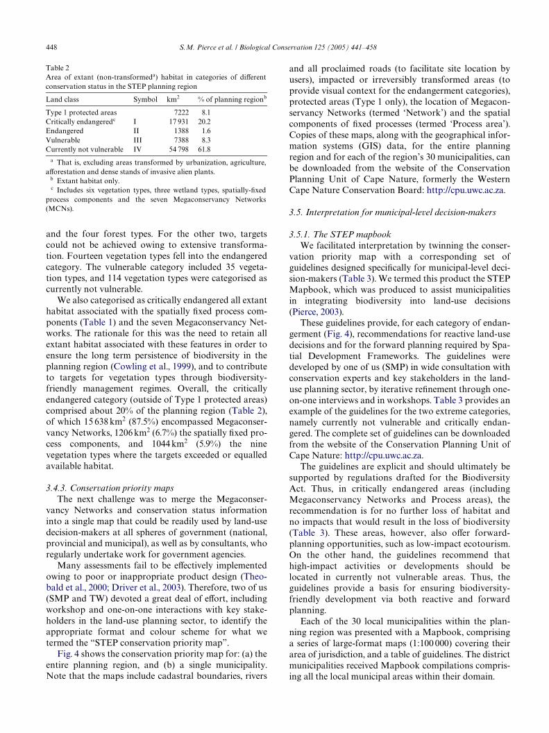
3.4.3. Conservation priority mapsThe next challenge was to merge the Megaconser-
vancy Networks and conservation status informationinto a single map that could be readily used by land-usedecision-makers at all spheres of government (national,provincial and municipal), as well as by consultants, whoregularly undertake work for government agencies.
Many assessments fail to be eVectively implementedowing to poor or inappropriate product design (Theo-bald et al., 2000; Driver et al., 2003). Therefore, two of us(SMP and TW) devoted a great deal of eVort, includingworkshop and one-on-one interactions with key stake-holders in the land-use planning sector, to identify theappropriate format and colour scheme for what wetermed the “STEP conservation priority map”.
Fig. 4 shows the conservation priority map for: (a) theentire planning region, and (b) a single municipality.Note that the maps include cadastral boundaries, rivers
Table 2Area of extant (non-transformeda) habitat in categories of diVerentconservation status in the STEP planning region
a That is, excluding areas transformed by urbanization, agriculture,aVorestation and dense stands of invasive alien plants.
b Extant habitat only.c Includes six vegetation types, three wetland types, spatially-Wxed
process components and the seven Megaconservancy Networks(MCNs).
Land class Symbol km2 % of planning regionb
Type 1 protected areas 7222 8.1Critically endangeredc I 17 931 20.2Endangered II 1388 1.6Vulnerable III 7388 8.3Currently not vulnerable IV 54 798 61.8
and all proclaimed roads (to facilitate site location byusers), impacted or irreversibly transformed areas (toprovide visual context for the endangerment categories),protected areas (Type 1 only), the location of Megacon-servancy Networks (termed ‘Network’) and the spatialcomponents of Wxed processes (termed ‘Process area’).Copies of these maps, along with the geographical infor-mation systems (GIS) data, for the entire planningregion and for each of the region’s 30 municipalities, canbe downloaded from the website of the ConservationPlanning Unit of Cape Nature, formerly the WesternCape Nature Conservation Board: http://cpu.uwc.ac.za.
3.5. Interpretation for municipal-level decision-makers
3.5.1. The STEP mapbookWe facilitated interpretation by twinning the conser-
vation priority map with a corresponding set ofguidelines designed speciWcally for municipal-level deci-sion-makers (Table 3). We termed this product the STEPMapbook, which was produced to assist municipalitiesin integrating biodiversity into land-use decisions(Pierce, 2003).
These guidelines provide, for each category of endan-germent (Fig. 4), recommendations for reactive land-usedecisions and for the forward planning required by Spa-tial Development Frameworks. The guidelines weredeveloped by one of us (SMP) in wide consultation withconservation experts and key stakeholders in the land-use planning sector, by iterative reWnement through one-on-one interviews and in workshops. Table 3 provides anexample of the guidelines for the two extreme categories,namely currently not vulnerable and critically endan-gered. The complete set of guidelines can be downloadedfrom the website of the Conservation Planning Unit ofCape Nature: http://cpu.uwc.ac.za.
The guidelines are explicit and should ultimately besupported by regulations drafted for the BiodiversityAct. Thus, in critically endangered areas (includingMegaconservancy Networks and Process areas), therecommendation is for no further loss of habitat andno impacts that would result in the loss of biodiversity(Table 3). These areas, however, also oVer forward-planning opportunities, such as low-impact ecotourism.On the other hand, the guidelines recommend thathigh-impact activities or developments should belocated in currently not vulnerable areas. Thus, theguidelines provide a basis for ensuring biodiversity-friendly development via both reactive and forwardplanning.
Each of the 30 local municipalities within the plan-ning region was presented with a Mapbook, comprisinga series of large-format maps (1:100 000) covering theirarea of jurisdiction, and a table of guidelines. The districtmunicipalities received Mapbook compilations compris-ing all the local municipal areas within their domain.

S.M. Pierce et al. / Biological Conservation 125 (2005) 441–458 449
3.5.2. The STEP HandbookWe believed that the outcomes of the conservation
assessment in the planning region needed to be supported
by additional interpretive material. Furthermore, withthe enactment of more stringent municipal and environ-mental legislation, it became apparent that land-use
Fig. 4. Conservation priority maps of (a) the entire STEP planning region and (b) the Kouga Municipality.

450S
.M. P
ierce et al. / Biological C
onservation 125 (2005) 441–458
Table 3Guidelines to assist municipal decision-makers and c
Category Brief descriptiong)
Opportunities for activities (Forward spatial planning)
Currently not vulnerable Ecosystems which cover most of their originalextent and which aremostly intact, healthyand functioning
r
dy
bed. can
as and
Depending on constraints (such as avoidance of spoiling scenery or wilderness, or infra-structure limitations), this category can withstand loss of or disturbance to natural areas. Subject to these constraints, this category may be suitable for a wide range of activities (e.g. extensive urban development, cultivation, tourist accommodation, ecotourism, game faming).
Critically endangered Ecosystems whose original extent has beenso reduced that they are under threat of collapse or disappearance. Included here are special ecosystems such as wetlands and indigenous forests
l cts
ry
et
d
ed
This category may be suitable foreco-friendly, nature-based activities with almost no impactsa such as responsible ecotourism (hiking trails, etc.). In those areas which have undergone severe impactsa, there are opportunities for Integrated Development Planning (IDP) restorationd projects, via poverty relief funding.
onsultants in fulWlling their legal and other obligations to the natural environment
General rule Procedures for municipalities (Reactive decisions)
Restrictions on activities(Forward spatial plannin
Depending on otherfactors, this categorycan withstand loss ofnatural habitat
1. Proposed disturbance or developments should preferablytake place on impacted areas.a
2. In response to an application for a non-listed activity which will havesevere or large-scale disturbance on a relatively undisturbed site (non-impacted), the municipality should Wrst seek the opinion of the local conservation organization.3. For a proposed “listed activity”,EIAb authorisation is required by law.
1. Proposed disturbance odevelopments should preferably take place on portions which have alreaundergone disturbance orimpactsa rather than on portions that are undistur2. In general, this categorywithstand loss of or disturbance to natural arethrough human activitiesdevelopments.
Under no circumstances can thiscategory withstand further loss ofnatural habitat
1. As a rule, no further loss of naturalarea and no further impactsa should be allowed.2. The municipality should require anon-site investigationc to verify the site’scondition relative to impactsa and itscategorization.2a. If the site has been severely impacteda,and is assessed as critically endangered, then the municipality should recommendrestorationd of the portion of land whichwill remain undeveloped, and its proclamation and management as a protected area.
No further loss of naturaarea and no further impashould be allowed. Any disturbance of this categoshould be allowed only oncondition that there are ngains for the natural environment (e.g. in the portion which will remainundeveloped), restorationand proclamation and management as a protectarea.

S.M
. Pierce et al. / B
iological Conservation 125 (2005) 441–458
451
endangered, Networks (MCNs), Process areas, protected areas and impacted (transformed) areas (adapted from Pierce, 2003).an development, cultivation, alien invasive plants, overgrazing); (2) extent of impact (degree of fragmentation); and (3) severity. Category (e.g. currently not vulnerable, Network, Process area) should be considered together with evaluation of impacts in
efore municipal decision-makers may allow certain “listed activities” in their area, they must Wrst receive the necessary EIAs to be arranged by the applicant. See Pierce (2003) (Appendix 1, Annexure 2) for further details on EIAs and “listed
actsa and then, depending on these Wndings, further assessment by a conservation oYcial or specialist consultant of thed, Network). This veriWcation is recommended because of the broad-scale (1:100 000) feature mapping used in the STEP
lants, wetland restoration, and replanting of degraded areas. See Pierce (2003) (Chapter 3, section 1.2) for Wnancing opportuni-
vegetation survey and categorisation of area according to the deWnitions of the STEP Handbook (Appendix 2); (2) evaluationory (e.g. critically endangered, Network); (4) if area is impacted and development is allowed, then recommendations for a netill not be developed, and its proclamation and management as a protected area).
2b. If the site is relatively undisturbed, with medium to low impactsa, and is veriWed as critically endangered, then the municipality should request a Special EIA.e
3. For a proposed “listed activity” that by law requires EIAb authorisation,the municipality should recommend a special EIA.e
Only two sample rows are given here; omitted are rows for vulnerable,a Impacts may be evaluated according to: (1) type of impact (e.g. urb
of impact (e.g. density of alien invasive plants, degree of overgrazing)order to make appropriate recommendation.
b EIA D environmental impact assessment. The law requires that bauthorisation from the relevant government department, which haactivities”.
c On-site investigation should involve Wrstly an evaluation of impsite’s vegetation type/s and categorisation (e.g. critically endangereProject.
d Restoration can involve the permanent removal of invasive alien pties.
e Special EIA here means an EIA which also takes into account: (1) aof impactsa; (3) permission only for development appropriate to categgain for the ecosystem (i.e. restorationd of the portion of land which w

452 S.M. Pierce et al. / Biological Conservation 125 (2005) 441–458
decision-makers at the municipal-level needed assistancein fulWlling their legal obligations regarding biodiversityconservation and environmental sustainability.
Therefore, the STEP Handbook (Pierce, 2003) wascompiled to provide further information to enable land-use decision-makers and private-sector consultants (act-ing on behalf of public or private sector agents) to makedevelopment decisions and recommendations, respec-tively, that do not violate the biodiversity conservationand environmental sustainability principles embodied inthe Biodiversity and Municipal Acts.
The Handbook also provides an explanation of theconservation assessment in lay terms; information on thevalue of biodiversity as a prerequisite for sustainability;legal obligations regarding biodiversity and sustainabil-ity; land reform and biodiversity; a guide to environmen-tal legislation and Environmental Impact Assessmentregulations from a planning perspective; and informa-tion on the recognition of biodiversity features for spe-cialist consultants. Information on the value ofbiodiversity was illustrated by case studies describing inbrief the economic importance of plants and animals, therole of the indigenous pollinator fauna in sustaining thefruit export industry, water supply and quality, indige-nous knowledge, ecotourism, beach sand replenishmentand carbon capture, as well as socio-cultural heritagevalue.
The STEP Handbook can be downloaded from thewebsite of the Conservation Planning Unit of CapeNature: http://cpu.uwc.ac.za.
4. Response of land-use decision-makers to the STEP products
The conservation priority map has been generallywell received by representatives of national, provincialand district municipal spheres, and by private consul-tants working for local municipalities. Owing to fundingdelays, the program to guide municipal decision-makersin the use of the STEP Handbook and Mapbooks hasonly recently been initiated (October 2004). Acceptanceof the Megaconservancy Network concept has also beenfavourable. Below we present an anecdotal account ofthe extent to which the study’s conservation assessmentproducts, hereafter referred to as STEP products, havebeen incorporated into land-use decision-making thusfar (see also BoshoV and Wilson, 2004).
4.1. National government and parastatals
The STEP products have been incorporated into theNational Biodiversity and Action Plan of the nationalDepartment of Environmental AVairs and Tourism andendorsed by the South Africa National BiodiversityInstitute (formerly the National Botanical Institute)
which has undertaken to catalyse and facilitate theimplementation of the STEP Project and its products inthe Eastern Cape Province. Furthermore, the STEPproducts are being used by South African NationalParks in the spatial planning for the expansion of theAddo Elephant and Mountain Zebra national parks; bythe Department of Water AVairs and Forestry to informtheir planning activities; and by the Electricity SupplyCommission, South Africa’s parastatal power utilitycompany, to inform the location of a major powerlineacross the planning region. The Development Bank ofSouth Africa, which provides institutional and othersupport to municipalities, has made compliance with theSTEP Project’s conservation plan mandatory for thesuccessful disbursement of loans and grants.
4.2. Provincial governments
The STEP products have been adopted by provincial-level planners for both the Western Cape and EasternCape Provinces for identifying the boundaries of, andpermissible impacts within, the evolving Gouritz andBaviaanskloof mega-reserves, two of the Megaconser-vancy Networks identiWed by the assessment (Fig. 2).Cape Nature, the conservation organisation for theWestern Cape Province, has endorsed the use of theSTEP products and has made compliance with these adefault in the compilation of their Spatial DevelopmentFrameworks for district and local municipalities withinthe planning region. The Department of EconomicAVairs, Environment and Tourism: Eastern Cape Prov-ince, the organisation responsible for conservation out-side of Type 1 protected areas, has used the STEPproducts in compiling the provincial conservation plan,which will ultimately inform the forthcoming ProvincialGrowth and Development Plan; this plan will, in turn,provide a spatially-explicit development guidelines forall government sectors in that part of the planningregion that falls within the province. The products wereincorporated into the Eastern Cape Province’s StrategicAssessment of Biodiversity of 2003 and its State of theEnvironment report of 2004.
Little success, however, has been achieved in engagingthe formal agriculture sector, especially at provincialgovernment level, despite involvement of relevantoYcials in the process. However, rural landowners haveviewed the Megaconservancy Network concept withinterest and enthusiasm.
4.3. Local government
The planning region includes a metropolitan munici-pality (the Nelson Mandela Metro comprising threelarge urban centres) and three district municipalities,each of which includes a number of local municipalareas. OYcials, planners and their consultants are using

S.M. Pierce et al. / Biological Conservation 125 (2005) 441–458 453
the STEP products to inform their spatial planning, butto varying degrees. Two district municipalities of theEastern Cape have formally requested their local munic-ipalities to comply with the planning guidelines in thecompilation of their Spatial Development Frameworks.Stewart et al. (2004) produced a Wne-scale (1:10 000)assessment for the Nelson Mandela Metro that used theSTEP Project’s approach to produce a conservation pri-ority map and the same associated guidelines. This prod-uct has been integrated into land-use decision-makingfor the metro.
STEP products are also being integrated into plan-ning for the municipality of the region’s second largestcity. Several of the smaller municipalities are using theproducts, although this is happening not through theinvolvement of municipal oYcials, but instead via con-sultants who are employed by municipalities to preparetheir Spatial Development Frameworks. Feedback fromthese consultants has been very positive and all regardthe products as user-useful and user-friendly. We knowof at least two cases where frameworks that used theSTEP products, have directed development away frompriority areas.
At this stage, an evaluation of the extent to which ofthe products have been eVectively integrated or mains-treamed into municipal decision-making is premature,and must await the completion of the recently initiatedcapacity building and training project based on theHandbook and Mapbook.
5. General discussion
Here, we Wrst evaluate the conservation assessmentapproach and its products, next we assess the extent towhich we have been successful in making these productsuseful, and Wnally we provide a general critique of ourstudy and make suggestions for improving futureinitiatives.
5.1. Evaluation of the conservation assessment for implementation
The implementation of conservation action is a nor-mative process, guided by human values and the conse-quent choices that people make (Callicott et al., 1999;Freyfogle and Newton, 2002). Therefore, in order toinXuence conservation decisions, conservation biolo-gists need to confront and comprehend the messy worldof institutions, policies and politics (MeVe, 1998), andreach beyond the biological sciences into economics,sociology, education and law (Robertson and Hull,2001; Orr, 2002b; Mascia et al., 2003). The discipline of“conservation planning” is a case in point: overwhelm-ing eVort has been devoted to reWning the scientiWc andtechnological aspects of the systematic assessment com-
ponent of what is, overall, a complex social planningprocess (Knight et al., in press). Equal eVort is nowrequired in designing products for implementers, illus-trated by, for example, the development of the conserva-tion priority map, the Handbook and Mapbook (Pierce,2003), as well as developing an implementation strategy.The development of the implementation strategy(Knight et al., 2003) took the same amount of time as thesystematic assessment, and was fraught with greaterchallenges.
The approach adopted for the assessment is signiW-cantly diVerent from the approach used for most othersystematic conservation assessments. Notably, we con-sidered implementation issues from the outset. Of partic-ular importance were the lessons that we learnt fromparticipating in the assessment for the Cape Action Planfor the Environment Project (Cowling and Pressey,2003), namely: (i) municipal-level decision-makers are akey stakeholder group since it is they who areempowered to make far-reaching decisions regardingbiodiversity, and (ii) assessment products must be bothuser-friendly and user-useful: products based on arbi-trary planning units and dynamic and often cryptic bio-diversity values (e.g. maps of irreplaceability) are notcomprehensible to most stakeholders working in theland-use planning sector (Driver et al., 2003).
Other factors that inXuenced our approach for thisassessment and developing its products were the promul-gation of the Municipal and Biodiversity Acts. Thesetwo pieces of legislation provide the principal instru-ments for ensuring that our assessment products arebeing integrated into municipal-level decision-making.They dictate the sphere of governance that we targetedand underpin the conservation status categories thatwere identiWed for diVerent land classes. Another inXu-ence on our approach is the growing armoury of munici-pal-level incentives for conservation on private land,currently being developed to facilitate the retention ofnatural habitat in priority areas (Botha, 2001). Finally,successfully implementing ecologically sustainable landmanagement on freehold land requires an optimal mixof complementary conservation and land-use instru-ments (Young et al., 1996). This led us to formulate anexplicit land management model, namely the Megacon-servancy Network concept (Knight and Cowling,2003a).
5.2. Evaluation of conservation status categories
While there have been other attempts to allocate landclass features to categories of endangerment (e.g. Nosset al., 1995; Reyers et al., 2001), this study is the Wrstattempt to use, in addition to habitat loss, an explicit anddefensible biodiversity target in identifying these catego-ries. Obvious problems with the method are the some-what arbitrary cutoVs between categories and lack of

454 S.M. Pierce et al. / Biological Conservation 125 (2005) 441–458
consideration of habitat fragmentation status of extantfeatures. Thus, a feature in the currently not vulnerablecategory could have a high level of anthropogenic habi-tat fragmentation and might better be located in the vul-nerable category. However, similar overall levels andconWgurations of habitat fragmentation may aVectdiVerent components of the biota diVerently (Collinge,2001). Until a clearer picture has emerged on the impactsof diVerent habitat fragmentation patterns on diVerentbiodiversity components, we believe it would be unwiseto change this system. We do note, however, that anyamount of Wne-tuning is unlikely to change the status ofcritically endangered and endangered features (unpub-lished data), these being the ones where habitat retentionis most critical. These thresholds can be reviewed period-ically, as provided for by the Biodiversity Act.
5.3. Evaluation of the conservation priority map
A major advantage of the conservation priority mapis that it provides information on the priority status offeatures (i.e. vegetation types and ecological and evolu-tionary process surrogates), as opposed to individualplanning units (e.g. grid squares), for the entire planningregion. Furthermore, the endangerment status categoriesare relatively stable over time, unlike in the case of mini-mum set analyses (Margules et al., 1994). The latterdeliver spatially dispersed arrays of priority planningunits that achieve biodiversity targets but provide noinformation on the remainder of the planning region.Moreover, any given minimum set solution is only oneof a host of diVerent spatial options for target achieve-ment (Balmford, 1998); land-use planners would requirethe appropriate data and software in order to assess thelikely impacts of habitat loss on biodiversity conserva-tion. While maps of irreplaceability do have the advantageof providing region-wide information on conservationvalue (Pressey, 1999), their information is provided forplanning units and relatively small changes in the statusof particular planning units may result in quite largechanges in the irreplaceability patterns. As is the case ofminimum set analysis, irreplaceability analysis isdynamic and requires capacitated personnel to eVec-tively use these tools for land-use planning. Our experi-ence from earlier conservation assessments such as theCape Action Plan for the Environment Project (Cowlingand Pressey, 2003) indicates land-use planners and otherstakeholders had great diYculties in comprehendingdynamic products (Driver et al., 2003).
5.4. Bridging the gap
While many have made the plea for improved integra-tion of systematic conservation assessment and land-useplanning approaches and products (Niämele, 1999; Pres-sey, 1999; Theobald et al., 2000; Stoms, 2001; Löfvenhaft
et al., 2002; Groves, 2003; MarzluV, 2004), we know ofno published examples that have sought, explicitly, tobridge the gap between these two sectors. This gap issymptomatic of the pervasive gap that exists between theproduction of scientiWc information and its provision informs useful to those who need it for implementation(Hulse et al., 2004). Clearly, if this gap is to be bridged ata much wider scale, the current academic focus upon sys-tematic assessment methodologies must be re-focussedupon implementation issues (Knight et al., in press).
This study has connected the outcomes of a system-atic conservation assessment with the needs of land-useplanners, resulting in the products that have beenendorsed by planning oYcials and consultants workingin this sector. In particular, they have appreciated theregion-wide depiction of conservation values, the stabil-ity of the products (at least over the Wve-year planningprocesses required by the Municipal Act), and the lackof requirement for GIS and other software capacity forroutine use. We are quite conWdent that our productshave achieved simultaneously the goals of systematicconservation planning (representation and persistence)in a format that is comprehensible and useful for munic-ipal-level decision-making. However, additional train-ing support will be required in poorly capacitatedmunicipalities.
5.5. Adoption of the products
In just eighteen months since their publication, theproducts have been surprisingly well integrated or mains-treamed into land-use decision-making across the plan-ning region, but especially in those organizations thatfulWl the prerequisites of adequate organizational andinstitutional capacity, eVective non-governmental organi-sation involvement, and awareness of the signiWcance ofbiodiversity (Cowling et al., 2002). Thus, the adoption ofthe products has been most eVective in the Nelson Man-dela Metro (Stewart et al., 2004), in the municipality ofthe region’s second largest city (BuValo City), and in thebetter-capacitated district municipalities (especially in theWestern Cape Province), in national and provincial orga-nizations, and amongst consultants.
The major constraints for eVective adoption at themunicipal level are a lack of awareness of the signiW-cance of biodiversity for social and economic sustain-ability, and poor governance and capacity in municipalorganizations. Because of the high levels of poverty andunemployment in our planning region, much greateremphasis is given to the social and economic pillars ofsustainability; generally, biodiversity and the naturalenvironment concerns are associated with the wealthyelite (see Turpie, 2003) and not regarded as a priority.Envisaging a healthy biosphere as the foundation foreconomic and social well being (Orr, 2002a; Dawe andRyan, 2003), or even as one of the three equally impor-

S.M. Pierce et al. / Biological Conservation 125 (2005) 441–458 455
tant pillars of sustainability, is certainly not a widelyheld view amongst municipal oYcials in the planningregion. However, when expressed in terms of cleanwater, suYcient forage for livestock, and a supply ofwild plants for food and medicine, biodiversity and theenvironment have much more meaning for the ruralpoor, as revealed in meetings between one of us (SMP)and oYcials and councillors from impoverished andpoorly capacitated municipalities. More eVort isrequired to clarify the signiWcance of biodiversity tohuman well-being in these municipalities.
Along with a lack of awareness of biodiversity issues, alack of capacity and poor governance in many municipal-ities in the planning region, there are a number of charac-teristics which are also hindrances to eVective integrationor mainstreaming of biodiversity concerns into land-useplanning (Smith et al., 2003). The amalgamation of smallneighbouring urban municipalities, a skills exodus, largebacklogs for social delivery to the very poor, and theadditional burden of servicing expanded rural areas, haveplaced a huge strain on the new municipal structures(Retief and Sandham, 2001). In most municipalities,ecosystem services are poorly understood, under sup-ported and not co-ordinated, and capacity for environ-mental conservation is mostly non-existent. A weak non-governmental organization sector (at least in conserva-tion) greatly hinders opportunities for eVective partner-ships for achieving environmental sustainability (Wellsand Brandon, 1993; Steiner et al., 2003).
In order for widespread adoption of the products tooccur throughout the planning region, much more atten-tion needs to be given to creating more eVective andaccountable governmental and non-governmental orga-nizations and institutions at the local scale (Burbidgeand Wallace, 1995; Brunckhorst, 1998). Hopefully, anincreasing awareness and appreciation of the value ofbiodiversity to material and spiritual well being (Orr,2002b) will be achieved by the capacity building projectfor training municipal oYcials and councilors in the useof the STEP Handbook and Mapbook. The project alsointends to expand the guidelines to incorporate all pro-vincial and national government sectors that inXuenceland-use decision-making.
5.6. General critique and suggestions for improvement
The overall approach we have adopted for this studyhas many shortcomings. Fortunately, planning is anongoing activity and Spatial Development Frameworksmust, by law, be repeated every Wve years. Therefore,there are many opportunities to improve the conserva-tion assessment products to enable stronger integrationinto municipal land-use planning. Below we providesome suggestions.
While the Handbook was aimed at increasing aware-ness of the value of biodiversity for the range of services
it provides, our conservation planning assessment usedbiodiversity features that emphasized existence ratherthan use values. Nonetheless, many of the features thatwe have targeted are of great value to other sectors withwhich alliances should be formed (Johns, 2003), namelytourism (e.g. sand movement corridors for beach replen-ishment, natural scenery and wildlife), water (mountaincatchments, riverine corridors and wetlands) and agri-culture (habitat for pollinators, grazing resources, cutXowers). The conservation of priority natural habitatadjacent to urban areas involves high opportunity costs.However, the retention of such areas provides an oppor-tunity to re-connect the urban poor to biodiversity (Pyle,2003) and maintain unbroken the heritage of indigenousknowledge and biodiversity-based tradition that existsamongst rural migrants who now live in urban centres(e.g. Cocks and Wiersum, 2003).
The features that support the services described abovecan be envisaged as critical natural capital, deWned byEkins et al. (2003) as “natural capital which is responsi-ble for important environmental functions and whichcannot be substituted in the provision of these functionsby manufactured capital”. We propose that stakeholdersbe involved in identifying and mapping diVerent formsof critical natural capital, and also in communicating itsimportance for sustainability to government and civilsociety. While economic assessments of the value of thiscapital would be welcome, we believe that impassionednarratives (Johns, 2003), Werce lobbying, eVective socialmarketing and other normative actions are likely to bemore eVective than often dubious monetary values(Chiesura and De Groot, 2003) in integrating the conser-vation of these features into land-use planning. Once thefeatures associated with critical natural capital havebeen mapped, it will be possible to assess the extent towhich they have achieved the biodiversity-based conser-vation targets. Assuming the establishment of eVectivelobby groups to protect the natural capital features, theresponsibilities of the conservation sector may shrinksigniWcantly as a greater slice of the citizenry is mar-shalled to protect biodiversity. Moreover, a greater over-all portion of intact habitat may be included in theprotection sphere, since the maintenance of some ser-vices may require habitat for which biodiversity targetshave already been achieved.
This brings us to the second major shortcoming ofour approach. Other than the Megaconservancy Net-works where connectivity for the maintenance of ecolog-ical processes is central, in cases where spatial optionsstill exist, our approach is very silent on exactly wherenatural habitat should be retained. We recommend(Table 3) that down to a certain threshold, loss of habi-tat can be tolerated in areas categorized as currently notvulnerable. Two problems arise. Firstly, this contradictsthe land-use planners’ perception towards avoidingdevelopment in currently “wild” areas; secondly, we are

456 S.M. Pierce et al. / Biological Conservation 125 (2005) 441–458
mute regarding the conWguration of habitat loss and theimpacts of progressive habitat fragmentation on the per-sistence of biodiversity (Theobald et al., 1997; Fahrig,2001; Flather and Bevers, 2002; Desmet, 2004; see Sec-tion 5.2). These problems are overcome to a certainextent by mapping the spatial components of processesrequired for the maintenance of biodiversity. Mappingof critical natural capital may also ensure the retentionof tracts of landscape that are larger than areas requiredby the biodiversity targets alone. However, in a perpet-ual growth economy, development and, hence, habitatfragmentation, have to occur somewhere. Our recom-mendation is to locate new development in areas whereconsiderable options remain to achieve targets. We doacknowledge that more attention must be given to theconWguration of habitat required for target achievementand biodiversity persistence.
Finally, the process of uptake and application of theseproducts by land-use planners requires monitoring. Nosuch programme is yet in place, although this will formpart of the training project discussed above. We supportthe assertion of Theobald et al. (2000) that the ability ofimplementers to describe the goals of programmes suchas the STEP Project, is an (at least) equally importantmeasure of success of conservation programmes as aremeasures of biodiversity features under conservationmanagement. People are, after all, not only the cause ofthe need for conservation eVorts, but also the solution.
Ours is a tentative step to bridge the gap between sys-tematic conservation assessment and land-use planning,and to ensure the integration of our products into land-use decision-making. It is much too early to say whetherwe have been successful, although the products arealready being used as inputs for land-use planning.Given that ongoing habitat loss is the greatest pressurefacing biodiversity, our approach represents an attemptto turn the tide by persuading land-use planners to focusdevelopment away from the areas most in need of con-servation. The land-use guidelines given in the Mapbookenable biologically informed decisions to be maderegarding retention of habitat and its loss to develop-ment, and highlight opportunities for biodiversity-friendly development in priority areas. Thus, theyembody a less conXict-ridden and crisis-centredapproach to conservation than is commonly the case(Redford and Sanjayan, 2003). It is still early in the day,but we believe this will be good news not only for biodi-versity conservation, but also for the people who dependupon it.
Acknowledgements
We acknowledge with deep appreciation the con-structive discussions with our colleagues and friends inthe conservation and land-use planning sectors. We are
grateful for the constructive comments from DenisSaunders and two reviewers. Thank you to Andre Bos-hoV, Mark Botha, Jayne Coleman, Mike Coleman, Allande Vries, Philip Desmet, Mandy Driver, Sarah Frazee,Gerhard Gerber, Ben Gericke, Gordon Johnson, Gra-ham Kerley, Kristal Maze, Carel Olivier, Nic Scarr,Warrick Stewart, Andries Struwig, Annelise Vlok, JanVlok, Amrei von Hase and Sharon Wilson. This studywas funded by the Global Environment Facility admin-istered by the World Bank, and the Development Bankof South Africa. Additional support was provided byConservation International’s Southern African Hot-spots Program, Mazda Wildlife Fund, Nelson MandelaMetropolitan University and the National ResearchFoundation (Pretoria).
References
Andrén, H., 1994. EVects of habitat fragmentation on birds and mam-mals in landscapes with diVerent proportions of suitable habitat: areview. Oikos 71, 355–366.
Anon., 1998. Local Government Information Series: A short guide tothe White Paper on Local Government. Department of Constitu-tional Development, Pretoria.
Balmford, A., 1998. On hotspots and the use of indicators for reserveselection. Trends in Ecology and Evolution 13, 409.
Beatley, T., Manning, K., 1997. The Ecology of Place. Planning forEnvironment, Economy and Community. Island Press, Washing-ton, DC.
BoshoV, A., Wilson, S., 2004. The STEP stakeholder participation pro-gramme: summary, comments and some lessons learned. TerrestrialEcology Research Unit Report No. 50, University of Port Eliza-beth, South Africa.
BoshoV, A.F., Kerley, G.I.H., Cowling, R.M., 2001. A pragmaticapproach to estimating the distributions and spatial requirementsof the medium- to large-sized mammals in the Cape FloristicRegion. Diversity and Distributions 7, 29–44.
BoshoV, A.F., Kerley, G.I.H., Cowling, R.M., 2002. Estimated spatialrequirements of the medium- to large-sized mammals, according tobroad habitat units, in the Cape Floristic Region. African Journalof Range and Forage Science 19, 29–44.
Botha, M.A., 2001. Conservation options for farmers and private land-owners. The Botanical Society of South Africa, Cape ConservationUnit, Report 01/2001.
Brunckhorst, D.J., 1998. Guest editorial. Creating institutions to ensuresustainable use of resources. Habitat International 22, 347–354.
Bunch, M.J., 2003. Soft systems methodology and the ecosystemapproach: a system study of the Cooum River and environs inChennai, India. Environmental Management 31, 182–197.
Burbidge, A.A., Wallace, K.J., 1995. Practical methods of conserving bio-diversity. In: Bradstock, R.A., Auld, T.D., Keith, D.A., Kingsford,R.T., Lunney, D., Sivertsen, D.P. (Eds.), Conserving Biodiversity:Threats and Solutions. Surrey Beatty & Sons, Sydney, pp. 11–26.
Callicott, J.B., Crowder, L.B., Mumford, K., 1999. Current normativeconcepts in conservation. Conservation Biology 13, 22–35.
Chiesura, A., De Groot, R., 2003. Critical natural capital: a socio-cul-tural perspective. Ecological Economics 44, 219–231.
Cocks, M.L., Wiersum, K.F., 2003. The signiWcance of plant diversityto rural households in Eastern Cape Province of South Africa. For-ests, Trees and Livelihoods 13, 39–58.
Collinge, S., 2001. Spatial ecology and biological conservation. Biologi-cal Conservation 100, 1–2.

S.M. Pierce et al. / Biological Conservation 125 (2005) 441–458 457
Cowling, R.M., Pressey, R.L., 2003. Introduction to systematic conser-vation planning in the Cape Floristic Region. Biological Conserva-tion 122, 1–13.
Cowling, R.M., Pressey, R.L., Lombard, A.T., Desmet, P.G., Ellis, A.G.,1999. From representation to persistence: requirements for a sus-tainable system of conservation areas in the species rich mediterra-nean-climate desert of southern Africa. Diversity and Distributions5, 51–71.
Cowling, R.M., Pierce, S.M., Sandwith, T., 2002. Conclusions: the fun-damentals of mainstreaming biodiversity. In: Pierce, S.M., Cowling,R.M., Sandwith, T., MacKinnon, K. (Eds.), Mainstreaming Biodi-versity in Development: Case Studies from South Africa. WorldBank, Washington, DC, pp. 143–153.
Cowling, R.M., Lombard, A.T., Rouget, M., Kerley, G.I.H., Wolf, T.,Sims-Castley, R., Knight, A.T., Vlok, J.H., Pierce, S.M., BoshoV,A.F., Wilson, S.L., 2003. A conservation assessment for the Sub-tropical Thicket Biome. Terrestrial Ecology Research Unit ReportNo. 43, University of Port Elizabeth, South Africa. Available from:http://cpu.uwc.ac.za.
Dawe, N.K., Ryan, K.I., 2003. The faulty three-legged-stool model ofsustainable development. Conservation Biology 17, 1458–1460.
Desmet, P.G., 2004. Application of systematic conservation planning inthe Succulent Karoo Biome of South Africa. Ph.D. thesis, Univer-sity of Cape Town.
Desmet, P.G., Cowling, R.M., 2004. Using the species-area relationshipto set baseline targets for conservation. Conservation and Society 9,11. http://www.ecologyandsociety.org/vol9/iss2/art11.
Driver, A., Cowling, R.M., Maze, K., 2003. Planning for living land-scapes: perspectives and lessons from South Africa. Center forApplied Biodiversity Science at Conservation International and theBotanical Society of South Africa, Washington, DC and Cape Town.
Ekins, P., Simon, S., Deutsch, L., Folke, C., De Groot, R., 2003. Aframework for the practical application of the concepts of criticalnatural capital and strong sustainability. Ecological Economics 44,165–185.
Fábos, J.G., 2003. Greenway planning in the United States: its originsand recent case studies. Landscape and Urban Planning 68, 321–342.
Fahrig, L., 2001. How much habitat is enough?. Biological Conserva-tion 100, 65–74.
Freemark, K.E., Boutin, C., Keddy, C.J., 2002. Importance of farmlandhabitats for conservation of plant species. Conservation Biology 16,399–412.
Flather, C.H., Bevers, M., 2002. Patchy reaction-diVusion and popula-tion abundance: The relative importance of habitat amount andarrangement. American Naturalist 159, 40–56.
Freyfogle, E.T., Newton, J.L., 2002. Putting science into place. Conser-vation Biology 16, 863–873.
Gelderblom, C.M., Kruger, D., Cedras, L., Sandwith, T., Audouin, M.,2002. Incorporating conservation priorities into planning guide-lines for the Western Cape. In: Pierce, S.M., Cowling, R.M., Sand-with, T., MacKinnon, K. (Eds.), Mainstreaming Biodiversity inDevelopment: Case Studies from South Africa. World Bank,Washington, DC, pp. 129–142.
Groves, C., 2003. Drafting a Conservation Blueprint. A Practitioner’sGuide to Planning for Biodiversity. Island Press, Washington, DC.
Hulse, D.W., Branscombe, A., Payne, S.G., 2004. Envisioning alterna-tives: using citizen guidance to map future land and water use. Eco-logical Applications 14, 325–341.
Huntley, B.J., Peterson, C., Cowling, R.M., Frazee, S., Maze, K., Sand-with, T., Sekhran, N., in press. Introduction. In: Peterson, C., Hunt-ley, B.J. (Eds.), Mainstreaming biodiversity in production sectorsand landscapes. South African National Biodiversity Institute,Cape Town.
Hutton, J.M., Leader-Williams, N., 2003. Sustainable use and incen-tive-driven conservation: realigning human and conservation inter-ests. Oryx 37, 215–226.
InWeld, M., Adams, W.A., 1999. Institutional sustainability and com-munity conservation: a case study from Uganda. Journal of Inter-national Development 11, 305–315.
Johns, D.M., 2003. Growth, conservation, and the necessity of new alli-ances. Conservation Biology 17, 1229–1237.
Kerley, G.I.H., Pressey, R.L., Cowling, R.M., BoshoV, A.F., Sims-Cast-ley, R., 2003. Options for the conservation of large- and medium-sized mammals in the Cape Floristic Region, South Africa. Biologi-cal Conservation 112, 169–190.
Knight, A.T., Cowling, R.M., 2003. Conserving South Africa’s “lost”biome. A framework for securing eVective bioregional conservationplanning in the Subtropical Thicket Biome. Terrestrial EcologyResearch Unit Report No. 44, University of Port Elizabeth, SouthAfrica. Available from: http://cpu.uwc.ac.za.
Knight, A.T., Cowling, R.M., 2003. The Megaconservancy Networkconcept: “Keeping people on the land in living landscapes”. Terres-trial Ecology Research Unit Report No. 45, University of Port Eliz-abeth, South Africa. Available from: http://cpu.uwc.ac.za.
Knight, A.T., BoshoV, A.F., Cowling, R.M., Wilson, S.L., 2003. Keep-ing people on the land in living landscapes: a co-operative strategyfor conserving landscapes and enhancing livelihoods in the Sub-tropical Thicket Biome. Terrestrial Ecology Research Unit ReportNo. 46, University of Port Elizabeth, South Africa. Available from:http://cpu.uwc.ac.za.
Knight, A.T., Cowling, R.M., Campbell, B.M., in press. Planning forimplementation: an operational framework for conservation plan-ning in production landscapes. Conservation Biology.
Löfvenhaft, K., Björn, C., Ihse, M., 2002. Biotope patterns in urbanareas: a conceptual model integrating biodiversity issues in spatialplanning. Landscape and Urban Planning 58, 223–240.
Margules, C.R., Pressey, R.L., 2000. Systematic conservation planning.Nature 405, 243–253.
Margules, C.R., Nicholls, A.O., Pressey, R.L., 1988. Selecting networksof reserves to maximise biological diversity. Biological Conserva-tion 43, 63–76.
Margules, C.R., Nicholls, A.O., M.B, 1994. Apparent species turnover,probability of extinction and the selection of nature reserves: a casestudy of the Ingleborough limestone pavements. ConservationBiology 8, 398–409.
MarzluV, J.M., 2004. Fringe conservation: call to action. ConservationBiology 16, 1175–1176.
Mascia, M.B., Brosius, J.P., Dobson, T.A., Forbes, B.C., McKean,M.A., Turner, N.J., 2003. Conservation and the social sciences.Conservation Biology 17, 649–650.
McHarg, I.L., 1969. Design with Nature. The Natural History Press,New York.
MeVe, G.K., 1998. Conservation biology: into the millennium. Conser-vation Biology 10, 916–917.
Miller, J.R., Hobbs, R.J., 2002. Conservation where people live andwork. Conservation Biology 16, 330–337.
Niämele, J., 1999. Ecology and urban planning. Biodiversity and Con-servation 8, 119–131.
Noss, R.F., LaRoe III, E.T., Scott, J.M., 1995. Endangered ecosystemsin the United States: a preliminary assessment of loss and degrada-tion. Biological report 28, National Biological Service. US Depart-ment Interior, Washington, DC.
Orr, D.W., 2002a. Four challenges to sustainability. Conservation Biol-ogy 16, 1457–1460.
Orr, D.W., 2002b. The Nature of Design. Ecology, Culture and HumanIntention. Oxford University Press, New York.
Pierce, S.M., 2003. The STEP Handbook and Mapbook: integratingthe natural environment into land-use decisions at the municipallevel: towards sustainable development. Terrestrial EcologyResearch Unit Report No. 47, University of Port Elizabeth, SouthAfrica. Available from: http://cpu.uwc.ac.za.
Pressey, R.L., 1998. Algorithms, politics and timber: an example of therole of science in a public, political negotiation process over new

458 S.M. Pierce et al. / Biological Conservation 125 (2005) 441–458
conservation areas in production forests. In: Wills, R.T., Hobbs,R.J., Fox, M.D. (Eds.), Ecology for Everyone: CommunicatingEcology to Scientists, the Public and the Politicians. Surrey Beattyand Sons, Chipping Norton, Australia, pp. 73–87.
Pressey, R.L., 1999. Applications of irreplaceability analysis to plan-ning and management problems. Parks 9 (1), 42–51.
Pyle, R.M., 2003. Nature matrix: reconnecting people and nature. Oryx37, 206–214.
Redford, K.H., Richter, B.D., 1999. Conservation of biodiversity in aworld of use. Conservation Biology 13, 1246–1256.
Redford, K., Sanjayan, M.A., 2003. Retiring Cassandra. ConservationBiology 17, 1473–1474.
Retief, F.P., Sandham, L.A., 2001. Implementation of integrated envi-ronmental management (IEM) as part of integrated developmentplanning (IDP). South African Journal of Environmental Law andPolicy 8, 77–94.
Reyers, B., Fairbanks, D.H.K., van Jaarsveld, A.S., Thompson, M.,2001. South African vegetation priority conservation areas: acoarse Wlter approach. Diversity and Distributions 7, 79–95.
Ribaudo, M.O., Hoag, D.L., Smith, M.E., Heimlich, R., 2001. Environ-mental indices and the politics of the Conservation Reserve Pro-gram. Ecological Indicators 1, 11–20.
Robertson, D.P., Hull, R.B., 2001. Beyond biology: toward a more pub-lic ecology for conservation. Conservation Biology 15, 970–979.
Rodrigues, A.S.L., Andelman, S.J., Bakarr, M.I., Biotani, L., Brooks,T.M., Cowling, R.M., Fishpool, L.D.C., da Fonseca, G.A.B., Gas-ton, K.J., HoVmann, M., Long, J.S., Marquet, P.A., Pilgrim, J.D.,Pressey, R.L., Schipper, J., Sechrest, W., Stuart, S.N., Underhill,L.G., Waller, R.W., Watts, M.E.J., Yan, X.l., 2004. EVectiveness ofthe global protected area network in representing species. Nature428, 640–643.
Rosenzweig, M.L., 2003. Reconciliation ecology and the future of spe-cies diversity. Oryx 37, 194–205.
Rouget, M., Cowling, R.M., Pressey, R.L., Richardson, D.M., 2003.Identifying spatial components of ecological and evolutionary pro-cesses for regional conservation planning in the Cape FloristicRegion, South Africa. Diversity and Distributions 9, 191–210.
Rouget, M., Cowling, R.M., Lombard, A.T., Knight, A.T., Kerley,G.I.H., in press. Designing large-scale conservation corridors forpattern and process. Conservation Biology.
Saunders, D.A., Craig, J.L., Mattiske, E.M. (Eds.), 1995. Nature Con-servation 4: the Role of Networks. Surrey Beatty & Sons, ChippingNorton, Australia.
Smith, R.J., Muir, R.D.J., Walpole, M.J., Balmford, A., Leader-Wil-liams, N., 2003. Governance and the loss of biodiversity. Nature426, 67–70.
Steenkamp, Y., Van Wyk, A.E., Victor, J.E., Hoare, D.B., Dold, A.P.,Cowling, R.M., Smith, G.F., in press. Maputaland-Pondoland-Albany. In: Mittermeier, R.A., HoVmann, M., Pilgrim, J.D., Brooks,
T.B., Mittermeier, C.G., Lamoreux, J.L., Fonseca, G. (Eds.), Hot-spots revisited: Earth’s biologically richest and most endangeredecoregions. Cemex, Mexico City.
Steiner, F., 2000. The Living Landscape. An Ecological Approach toLandscape Planning. McGraw-Hill, New York.
Steiner, A., Kimball, L.A., Scanton, J., 2003. Global governance for theenvironment and the role of Multilateral Environmental Agree-ments in conservation. Oryx 37, 227–237.
Stewart, W.I., Cowling, R.M., Martin, A.P., du Preez, D.R., Lombard,A.T., 2004. A biodiversity conservation assessment and frame-work for the open space system for the Nelson Mandela Metro-pole, Cape Floristic Region, South Africa. BiodiversityConservation Unit, Wildlife and Environment Society, Port Eliz-abeth.
Stoms, D.M., 2001. Integrating biodiversity into land-use planning.National Planning Conference of the American Planning Associa-tion, March 2001, New Orleans, USA.
Theobald, D.M., Mills, J.R., Hobbs, N.T., 1997. Estimating the cumula-tive eVects of development on wildlife habitat. Landscape andUrban Planning 39, 25–36.
Theobald, D.M., Hobbs, N.T., Bearly, T., Zack, J.A., Shenk, T., Rieb-same, W.E., 2000. Incorporating biological information in localland-use decision-making: designing a system for conservationplanning. Landscape Ecology 15, 35–45.
Turpie, J.K., 2003. The existence value of biodiversity in South Africa:How interest, experience, knowledge, income and perceived level ofthreat inXuence local willingness to pay. Ecological Economics 46,199–216.
United Nations Conference on Environment and Development, 1992.Convention on biological diversity. In: Proceedings of the UnitedNations Conference on Environment and Development, Rio deJaneiro, Brazil, June 1992. Department of Public Information,United Nations, New York.
Van Wyk, A.E., Smith, G.F., 2001. Regions of Floristic Endemism inSouthern Africa. A Review with Emphasis on Succulents. UmdausPress, HatWeld, South Africa.
Vlok, J.H.J., Euston-Brown, D.I.W., Cowling, R.M., 2003. Acocks’ Val-ley Bushveld 50 years on: new perspectives on the delimitation,characterisation and origin of thicket vegetation. South AfricanJournal of Botany 69, 27–51.
Wells, M.P., Brandon, K.E., 1993. The principles and practice of buVerzones and local participation in biodiversity conservation. Ambio22, 157–162.
Young, M.D., Gunningham, N., Elix, J., Lambert, J., Howard, B.,Grabosky, P., McCrone, E., 1996. Reimbursing the future: an eval-uation of motivational voluntary, price-based, property-right, andregulatory incentives for the conservation of biodiversity, Part 1.Biodiversity Series, Paper No. 9. Department of the EnvironmentSport and Territories, Canberra, Australia.