system wide information management (swim) program overview...
TRANSCRIPT

Global Harmonization
Through Collaboration
System Wide Information
Management (SWIM) Program
Overview
Presented By: Ahmad Usmani,
Program Manager,
SWIM
Date: August 30, 2012

• Background
• Segment 1
• Segment 2
• Governance
• Standards
• International Coordination
Agenda
2

Program Definition
The SWIM Program:
– Implements a Service-Oriented Architecture (SOA) in the
National Airspace System (NAS)
In order to:
– Allow the FAA to create reusable system interfaces more quickly
and cost effectively
– Facilitate interoperability and data-sharing needed for NextGen
SWIM consists of standards, infrastructure, and governance that
enable the management of Air Traffic Management related
information and its exchange between qualified parties via
interoperable services. (ICAO Working Paper)
3

Conceptual Overview
FTI IP Backbone
SWIM Messaging Infrastructure
WXXMFIXMAIXM
Standards for Data Exchange
En RouteControllers
TerminalControllers
Non-FAA Users(e.g., Airlines, DoD
DHS, ANSPs)FAA
Command CenterNextGen Applications
SystemDevelopers
4
En Route

Segmented Approach to SWIM
• SWIM Segment 1:
― Implementation of a set of federated services in the NAS with SWIM-provided governance, standards, and software to support development of reusable SOA services
― SWIM provides requirements, schedule, and funding to seven SWIM Implementing Programs (SIPs)
― Segment 1 results in SOA services deployed to all Air Route Traffic Control Centers (ARTCCs), 39 Terminal Radar Approach Controls (TRACONs), the Air Traffic Control System Command Center, the William J. Hughes Technical Center (WJHTC), and NAS Enterprise Management Centers (NEMCs)
• SWIM Segment 2:
― Continues provision of governance, standards, and software to additional NAS programs
― Implements enterprise messaging service for other NAS programs and facilitates transition by Segment 1 SIPs
5

Reroute Data Exchange
Special Use Airspace (SUA) Automated
Data Exchange1
Corridor Integrated Weather System
(CIWS) Publication
Integrated Terminal Weather System (ITWS)
Publication
Pilot Report (PIREP) Data Publication
Flight Data Publication
SWIM Terminal Data Distribution System
(STDDS)2
Flow Information Publication
Runway Visual Range (RVR) Publication
Operational 2012 completion 2013 completion 2015 completion
Notes: 1 AIM SUA declared Initial Operating Capability (IOC) in December 2011 2 STDDS declared IOC in May 2012
Current SWIM Capabilities
6
Currently using, or considering use:
AIXM
WXXM
FIXM

FDPS
7
FTI
Proposed FDPS Services
En Route Flight Data Service En Route Airspace Data Service En Route Operational Data Service En Route General Message Service
NEMS
NEMS NESG ARTCC
NAS Users
Non-NAS Users
ER
AM
EDDS
FDP
S
• SWIM identified an alternative approach to develop and deploy FDPS
– Approach uses data available from En Route Data Distribution System (EDDS) with no impact to ERAM
– Development to be performed by Volpe and William J. Hughes Technical Center (WJHTC) team
• FDPS will provide a SWIM-compliant flight data service to NAS and non-NAS users
– Original requirements expanded to include International Civil Aviation Organization (ICAO) 2012 and Flight Information eXchange Model (FIXM) considerations
– Consistent with National Flight Information Service and architecture
– Supports goal of Common Message Set (CMS)/Host-Automation Data Distribution System (HADDS) migration

Current SWIM Products Capability Products
AIM SUA Data
Exchange
• SUA data, dynamically provided in the AIXM standard
• AIXM SUA definitions
ITWS Data
Publication
• Airport Lightning Warning
• Configured Alerts
• Forecast Accuracy
• Forecast Contour
• Forecast Image
• Gust Front TRACON Map
• Microburst TRACON Map
• Precipitation 5nm
• Precipitation Long Range
• Precipitation TRACON
• SM SEP 5nm
• SM SEP Long Range
• SM SEP TRACON
• Terminal Weather Text Normal
• Tornado Alert
• Tornado Detections Wind Profile
• AP Indicated Precipitation
• AP Status
• Gust Front ETI
• Hazard Text 5nm
• Hazard Text Long Range
• Hazard Text TRACON
• ITWS Status Information
• Microburst ATIS
• Runway Configuration
• Storm Motion 5NM
• Storm Motion TRACON
• Terminal Weather Text Special
• Wind Shear ATIS
CIWS Data
Publication
• VIL Mosaic (1km resolution)
• VIL 2-hr. Forecast
• Echo Tops Mosaic (1 km resolution)
• Echo Tops 2-hr. Forecast
• Satellite Mosaic
• Storm Info: Echo Top Tags
• Storm Info: Leading Edges
• Storm Info: Motion Vectors
• VIL Forecast Contours (Std. Mode)
• VIL Forecast Contours (Winter Mode)
• Echo Tops Forecast Contours
• Growth & Decay Contours
• Forecast Accuracy: Echo Tops
• Forecast Accuracy: Std. Precip
• Forecast Accuracy: Winter Precip
PIREP Data
Publication
• Transmission of voice PIREPs to
WMSCR
• Stored PIREPs • Altimeter settings
Reroute Data
Exchange
• Pre-departure flight reroute information between Traffic Managers and Air Traffic Controllers
ASDE-X/STDDS • ASDE-X streaming data service • Surface Movement Events (SME) • Tower Departure Events (TDE)
Flow Information
Publication
• Flow Constrained Area (FCA)
• Airspace Flow Program (AFP)
• Ground Delay Program (GDP)
• Ground Stops (GSs)
• Reroutes
• Advisories
RVR Data Pub. • Runway visibility data
Flight Data Pub. • Flight data
8

• NAS Service Registry/Repository (NSRR), a central repository to help users discover, use and (whenever possible) reuse web services
– Lets users know what NAS information
is available and how to receive it
– Registering with the NSRR will be the
only way to receive FAA NAS data
• SWIM Commercial-Off-The-Shelf (COTS) Products Repository
• SWIM Wiki
Service Consumer
Service Provider
NSRR
Exchange Messages
Publish and Register
Contract
Discover and Retrieve
Contract
https://swimrep.faa.gov/soa/web/login
Segment 1 Enterprise Infrastructure and Tools
9

Transition From Segment 1 To Segment 2
• Segment 1 – Federation among Programs
– No common infrastructure
– Each Program responsible for message delivery using SWIM-provided software
– Governance policies/processes to ensure interoperability
• Segment 2 – Common Infrastructure
– SWIM provides common messaging infrastructure
– SWIM responsible for message delivery
– More agile Governance (i.e. not dependent on SWIM-provided software)
– SWIM will assist Segment 1 Programs in transition to new infrastructure
10

Segment 2 Infrastructure
11
• NAS Enterprise Messaging Service (NEMS)
– Prototype messaging
nodes deployed
– Additional nodes will be
installed
• Domain Name Service (DNS)
– Capability deployed and
operational
• Network Time Protocol/Precision Time Protocol (NTP/PTP)
– Capability deployed and
operational
Current NEMS Nodes

NEMS Overview
• Any service available on one NEMS node will be available on any other NEMS node
• Intelligent Routing, routing decisions made based on certain data attributes or pre-defined conditions
• Data Filtering, based on Java Messaging Service (JMS) message header contents or attributes of the Extensible Markup Language (XML) schema
• Meets Enterprise Boundary Protection (EBP) requirements through integration with the NAS Enterprise Security Gateway (NESG)
NEMS is providing Messaging Services for the NAS
12

SOA Suitability Assessments
13
• Purpose – To determine which FAA programs need to use SOA/SWIM services
– To plan SWIM funding and SWIM infrastructure for future customers
– Ensure SWIM compliance in programs, as needed
– Provide cost estimates to FAA programs of using SWIM services
• Timeline – The SOA Suitability Assessment process starts in the early stages of the
program lifecycle, at Investment Analysis Readiness Decision (IARD) with the SOA scorecard questionnaire
– Engagement with the candidate program continues through Initial Investment Decision (IID) and Final Investment Decision (FID), and completes with a SWIM Memorandum for the FID

SOA Suitability Results
14
Program SOA Score
Alaska Satellite Telecommunications Infrastructure (ASTI) Low
ATO Resource Management Tool Medium
Airport Surveillance Radar-Model 9 (ASR-9) and Mode-Select (Mode-S) Service Life
Extension Program (SLEP) Phase II Medium
Automatic Terminal Information System (ATIS) Low
Aviation Environmental Design tool (AEDT) High
Aviation Safety Knowledge Management Environment (ASKME) Segment 2 High
Aviation Surface Weather Observation Network (ASWON) High
ERAM D-Position Upgrade and System Enhancements Low
Facility Security Risk Management (FSRM) (Phase 2) Medium
Flight Standards Inspector Aircraft Replacement (FSIAR) Low
Instrument Flight Procedures Automation (IFPA) (Includes Tech Refresh) High
Logistics Center Supply System (LCSS) Segment 2 Medium
Mobile Airport Surveillance Radar (MASR) High
Next Generation Radar (NEXRAD) SLEP High
Surveillance and Broadcast Services (SBS) High
Surveillance Interface Modernization (SIM) High
System of Airports Reporting (SOAR II) High
Terminal Automation Modernization & Replacement (TAMR) Phase 3 Segment 2 Medium
Tower Flight Data Manager (TFDM) High
Wind Shear Detection Services (WSDS) Work Package (WP) 1 (Tech Refresh) Low
• Two-Way SOA will enhance NAS Boundary Protection System (NBPS)
– Securely allow external entities to publish information using SOA services into the NAS
• Two-Way SOA components include:
– Traffic Director (TD)
– Web Application Firewall (WAF)
– XML Gateway
• Scheduled availability June 2013
Two-Way SOA
15

FAA Standards Developed By SWIM
FAA-STD-063 XML Namespaces
Requirements for
namespaces in XML
documents
FAA-STD-064 Web Service
Registration
Requirements for
registering services and
minimum content for
documenting services
FAA-STD-065 Web Service
Description
Documents
Minimum content for
documenting properties
and capabilities of web
services
FAA-STD-066 Web Taxonomies
Minimum set of
taxonomies to
categorize service
metadata
FAA-STD-070 Preparation of Web
Service Requirements
Documents
Content and structure of
a Web Service
Requirements
Document (WSRD)
16

• International Civil Aviation Organization (ICAO)
– Air Traffic Management (ATM) Requirements and Performance Panel (ATMRPP)
• Single European Sky ATM Research Joint Undertaking (SESAR JU)
– Information Management Workgroup
– SWIM Interoperability Coordination Plan
• Japan Civil Aviation Bureau (JCAB)
– Future Air Transportation System (FATS) Working Group • May 2011, United States
• October 2011, Japan
• May 2012, United States
– Asia/Pacific Flight Data Object Demo (May 2012)
• Civil Aviation Authority of China/
Air Traffic Management Bureau (CAAC/ATMB) • December 2010, China
• March 2011, United States
• September 2011, United States
• October 2011, China
• Airservices Australia (ASA)
– Asia/Pacific Flight Data Object Demo (May 2012)
International Coordination
17
Aircraft Access to SWIM (AAtS)
• What is AAtS?
– AAtS - The aircraft is accessing SWIM
o Qualified subscribers consuming NAS data on the flight deck such as meteorology and aeronautical information
• Why AAtS?
– Provides in-flight users access to the same information / decision support tools that FAA and AOCs have
– Supports NextGen Collaborative Decision-Making
18
To learn more about SWIM…
The SWIM website describes the SWIM program and provides news, announcements, and information on current issues It also contains key documentation, including select briefings, the SWIM Newsletter, and SWIM Q&A
www.swim.gov
19

Questions
20

Backup
21
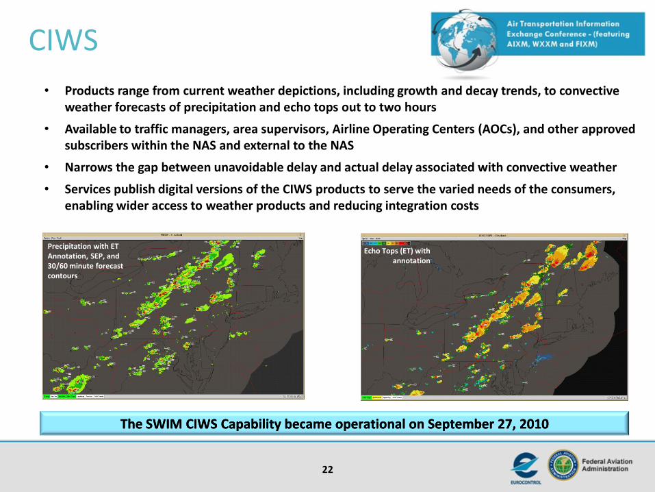
CIWS
22
Echo Tops (ET) with annotation
Precipitation with ET Annotation, SEP, and 30/60 minute forecast contours
• Products range from current weather depictions, including growth and decay trends, to convective weather forecasts of precipitation and echo tops out to two hours
• Available to traffic managers, area supervisors, Airline Operating Centers (AOCs), and other approved subscribers within the NAS and external to the NAS
• Narrows the gap between unavoidable delay and actual delay associated with convective weather
• Services publish digital versions of the CIWS products to serve the varied needs of the consumers, enabling wider access to weather products and reducing integration costs
The SWIM CIWS Capability became operational on September 27, 2010The SWIM CIWS Capability became operational on September 27, 2010
Echo Tops (ET) with annotation

ITWS
23
•Improves and enhances NAS efficiency and capacity by creating and displaying weather products at selected NAS pacing airports to AOC dispatchers and traffic managers •Provides ITWS products digitally to the AOCs and other subscribers onto user workstation displays for greater common situational awareness •Using SWIM standards reduces integration costs for weather information while enabling wider access to weather products
ITWS information accessed through ITWS Situation Display
ITWS Data Publication became operational on January 25, 2011ITWS Data Publication became operational on January 25, 2011
ITWS information accessed via Internet

PIREP Data Publication
24
PIREP-GA
(TCP-IP)
ARTCCs NNCCs
WMSCR ERAM
Airlines
Subscribe
E-PIREP
PIREP-GA
SWIM/FTI
E-PIREP
(TCP-IP)
Publish E-PIREP, GA-PIREP,
altimeter data
FS-21
Subscribe
E-PIREP
PIREP-GA
Voice
PIREP
E-PIREP: Electronic
PIREPS generated by en-
route controllers
PIREP-GA: PIREPS
generated by General
Aviation
FD
PS
• WMSCR will provide web services to create and retrieve PIREP weather data reports
• Capture of crucial pilot observations and distribution of these to other NAS users by WMSCR via the SWIM service
will significantly enhance NAS safety and greatly increase the scope of coverage of the pilot reported weather
product
• Phase 1 of WMSCR Data Publication is complete and installed in June 2012 for data consumption within the NAS
– Future phases of this service will provide for customer consumption external to NAS and additional features and services
• A new capability will be developed for En Route controllers to receive these voice reports from pilots, enter into
ERAM directly and distribute them to WMSCR through Flight Data Publication Service (FDPS) as SOA services.
WMSCR will distribute the PIREPs to other NAS users. FDPS will also subscribe to the PIREPS from WMSCR and
distribute to ERAM as needed.

STDDS
25
• Is a web service enabled IP-based front end to several Terminal legacy systems
– Existing flight data interfaces to Terminal are antiquated and are limited to receiving a subset of the available data
• Will allow for the flow of information and make available status event information previously only available in Terminal
• An operational STDDS prototype installed at the TRACON in Windsor Locks, CT, declared IOC in May 2012. Full deployment is expected to be completed in 2014 at 39 TRACONs with feeds from approximately 100 Towers