system and architecture of an adapted situation awareness
TRANSCRIPT
Robles Perez et al. ASSISTANCE Architecture
System and Architecture of an AdaptedSituation Awareness Tool for First
Responders
Debora Robles Perez�
Communications Department – UniversitatPolitècnica de Valè[email protected]
Manuel Esteve DomingoCommunications Department – Universitat
Politècnica de València
Israel Perez LlopisCommunications Department – Universitat
Politècnica de València
Federico J. Carvajal RodrigoCommunications Department – Universitat
Politècnica de València
ABSTRACT
First responders (FRs) in Europe are currently facing large natural and man-made disasters (e.g. wild fire, terroristattacks, industrial incidents, big floods, gas leaks etc.), that put their own lives and those of thousands of others atrisk. Adapted situation awareneSS tools and taIlored training curricula for increaSing capabiliTies and enhANcingthe proteCtion of first respondErs (ASSISTANCE) is an ongoing European H2020 project which main objective isto increase FRs Situation Awareness (SA) for helping and protecting di�erent kinds of FRs’ organizations that worktogether in large scale disasters mitigation. ASSISTANCE will enhance the SA of the FRs organisations duringtheir mitigation activities through the integration of new paradigms, tools and technologies (e.g. drones/robotsequipped with a range of sensors, robust communications capabilities, etc.) with the main objective of increasingboth their protection and their e�ciency.
Keywords
Critical Infrastructure Protection, First Responder, Command and Control, Autonomous Vehicles, Resilience.
INTRODUCTION
ASSISTANCE presents a holistic solution that will adapt a well-tested Situational Awareness (SA) application asthe core of a wider SA platform. The ASSISTANCE’s platform will be capable of o�ering di�erent configurationmodes for providing the tailored information needed by each FR organization while they work together to mitigatethe disaster (e.g. real time video and resources location for firefighters, evacuation route status for emergencyhealth services and so on). This Work in Progress (WiP) Paper is organized into 4 main sections. The first of thesesections outlines a brief review of relevant literature and related work, which will be analyzed displaying actualtechnical advances in SA areas. Reviewing the state of art leads ASSISTANCE to a solution that will enhance theSA of the responding organizations during their mitigation activities through the integration of new paradigms,tools and technologies (e.g. drones/robots equipped with a range of sensors, robust communications capabilities,etc.) with the main objective of increasing both their protection and their e�ciency. In addition, the project isextremely focused on tangible solutions, which will lead to on field testing. As a consequence, ASSISTANCEproject proposes 3 demo pilots, that will be shown in the next section, for ensuring its results validation in controlledenvironments with all consortium end users direct involvement. The description of the pilots will be contextualizedby real disaster use-cases. Following, a section explaining the ASSISTANCE system and architecture will bedetailed, designed on the outcomes of several questionnaires filled in during the preparation phase by 18 FRsEuropean organizations in terms of self-protection and capabilities enhancement. The user requirements comprise
�Corresponding author
WiP Paper – Technologies for First RespondersProceedings of the 17th ISCRAM Conference – Blacksburg, VA, USA May 2020
Amanda Lee Hughes, Fiona McNeill and Christopher Zobel, eds. 928
Robles Perez et al. ASSISTANCE Architecture
mainly functional demands, but FRs users also specified non-functional requirements identifying physical orperformance characteristics. ASSISTANCE project will use robots and drones’ swarms, UAVs and smart wearablesensors, all equipped with specific sensors for covering the FRs specific data needs. The sensors mounted onunmanned platforms along with the ones mounted on the FRs’ equipment will be integrated in a complete SituationAwareness Platform (SAP) that will also include innovative modules that will improve the FRs’ SA and capabilitiesfor performing their work in a more e�cient and secure manner. Furthermore a description of the ASSISTANCEnetwork architecture will be discussed presenting a high-level overview of the three main segments. Overall, WiPlast section displays a conclusion comments to the current ASSISTANCE system.
RELATED WORK
In this section, we review and summarize a few research and commercial disaster management information systemsused by di�erent FRs Organizations for increasing ASSISTANCE’s current capabilities enhancing their SA. It shouldbe noted that, in order to compare our system as objectively as possible, the following projects or software pursueASSISTANCE’s similar goals. ALADDIN (2017-2020) is a European Commission (EC) H2020 call ongoing projectdedicated to neutralize drones, but focused in protecting critical infrastructures. In addition, the main research ofALADDIN is regarding detection and tracking using complex formats for its neutralization. ASSISTANCE insteadis focused on providing a tool for FRs in order to protect them during the mitigation of a large event in an easy wayto use. ICARUS (2012-2016) was a EC FP7 call project aimed to decrease the total cost, both in human lives andin expenses terms, of a major crisis. Their approximation was based on the use of unmanned platform for rescuevictims. ASSISTANCE will use a wider range of di�erent UAVs, drones and robots adapted to the FRs informationneeds in di�erent scenarios for increasing their SA and protect them against unexpected dangers. In addition, theSA capabilities proposed in ASSISTANCE goes beyond to the Command, Control, Communications, Computers, &Intelligence (C4I) system developed in ICARUS, since their C4I only acts as integration platform without o�eringany added value to the FRs Organizations as for example the FRs Wearable Sensors, UAV&Drones’ AdvancedCapabilities, Augmented Video Fusion and so on. DragonForce DRAKONTAS (n.d.) is a commercial mobile teamcollaboration platform that delivers mission-critical command and control and incident management capabilities inreal time. As in ASSISTANCE it integrates real-time personnel tracking, instant text messaging among individualsand groups, plus online storage and data sharing capabilities, digital forms and situation reports, and an interestingteam capability that turns any map, picture or floor-plan into a shared whiteboard. Homeland Security (2016)application is a counter explosive tool that puts key decision making data, such as safe stando� distances, damageand injury contours, nearby areas of concern, and suggested roadblocks, directly at responders’ fingertips. As adisadvantage, it lacks of user and group communications. IMPACT (n.d.) is a Geographical Information System(GIS) tool easy to use by non-GIS professionals as first responders, designed to enhance SA, communication,preparedness and coordination for security events. FRs can use it for planning, situation awareness, and responseto natural and man-made disasters for Impact Examples (n.d.): wildfire monitoring, plume model, evacuationplans, line-of-sight, evacuation simulation among other. ASSISTANCE will benefit and continue from IMPACTachievements. CommandX (n.d.) is a commercial system for emergency communications where a workplace cancommunicate with multiple instances locally or via a network connection. As in ASSISTANCE situation map isrunning on the communication server, making possible that multiple users can access it simultaneously, with animportant di�erence, CommandX works with ArcGIS by ESRI (n.d.), a proprietary geodata infrastructure.
USE CASES AND PROPOSED PILOTS
Among the increasing natural or man-made disasters FRs’ ASSISTANCE potential will be tested using the followinguse-cases: Earthquake, industrial accident and terrorist attack; although in each pilot we will be focusing in di�erentinnovative modules that will enhance and secure FRs’ SA beyond the state of the art, all the system would betested. In this section, we summarize the Use-Cases (UC) and the Pilots (P) scenarios, where each pilot will be ledby a di�erent type of FRs organization, while the others consortium FRs will cooperate with them as in a real disaster.
UC1 Earthquake. In 2015, Nepal su�ered a 7.8 (in the Richter scale) magnitude earthquake, damaging thelocal telecommunications infrastructure, showing up di�culties within the Government’s Emergency Response(Shrestha and Pathranarakul 2018). Coburn and Spence (2003) suggested that having a pre-earthquake emergencyplan can be one of the best ways to ensure an e�ective response. Nevertheless, emergency plans should be realisticand pragmatic (Alexander 2015).
P1 Earthquake (Izmir, Turkey). The beginning situation for this pilot is that a 7.8 magnitude earthquakelike in Nepal strokes urban environment during the night time. Therefore, many buildings have collapsed or areseverely damaged and main commercial communication networks have been heavily a�ected.
WiP Paper – Technologies for First RespondersProceedings of the 17th ISCRAM Conference – Blacksburg, VA, USA May 2020
Amanda Lee Hughes, Fiona McNeill and Christopher Zobel, eds. 929

Robles Perez et al. ASSISTANCE Architecture
Network coverage will be provided by Ad Hoc network using drones’ swarm equipped with Wi-Fi access points.Victims have to be transported to the available hospitals. Information on optimal routes, which include real-timeinformation on damaged infrastructures and CBRN Hazard module will be tested. Last one will be mounted onunmanned platforms (drones or robots) and will project on a GIS thought layers’ potential hazard footprints in realtime.
UC2 Industrial Accident. The largest industrial catastrophe in history took place in 1984 in Bhopal(Labakaet al. 2013), India, through a gas leak. Many FRs died and the rest of them got overwhelmed handling the situationoccurred due to the lack of several technical capabilities. To mention a few: troubles identifying the gas type, lackof resources or adequate transport and routing for emergency evacuations (Bisarya and Puri 2005).
P2 Industrial accident (Rotterdam Rijnmond area, The Netherlands). A big fire is developing in a chemicalwarehouse destroying various chemical products, producing large amounts of potentially toxic fumes.
CBRN Hazard module will project on GIS layers gas cloud dispersion models and/or toxic footprint predic-tions continuously updated by measurements from sensors mounted on unmanned platforms. This way, FRs willincrease their protection and it will allow them to correctly inform, alarm or even evacuate specific areas.
UC3 Terrorist attack. On 21 April 2019, Easter Sunday, in 20 minutes, eight coordinated bombs went o�in popular hotels and historical churches across Colombo. Later in the day, there were smaller explosions at ahousing complex and a guest house, killing mainly police o�cers who were investigating the situation raidingsuspect locations (Amarasingham 2019). Another issue to deal with in terrorist attacks as in Manchester bombing2017 (Mirbabaie et al. 2018) is that often disrupt communications infrastructures, through either damage or otheractions of the belligerents. Such riots also a�ect the development and extension of telecommunications infrastructure.
P3 Terrorist attack (Seville, Spain). During the Seville Feria’s week, with a 3,5 million people attending, atruck crash in the Maestranza bullring (2km distance from the feria enclosure) and a big explosion takes place; panicstarts. Many calls arrive to the emergency services with breathing di�culties or troubles escaping. Two unknowndrones are within the area. These facts alert the FRs on the potential presence of a toxic agent/substance and maybemalevolent drones in the area. Ten minutes later when all LEAs resources are focused in the bullring area trying toknow what has happened, a suspicious tank truck is detected going very quickly to the direction of the feria mainentrance, where a large crowd is being evacuated.
FRs on field will use the HMI in order to lock the drones as a target and after that a friendly drone dulymodified will follow the suspicious drone automatically and will performs its interception through the use of netlaunched. Mission management module will allow to improve the collaboration between the FRs and the asset andpayload operators at this evolving scenario, giving them a full awareness situation, preventing second attacks.
ASSISTANCE SYSTEM AND ARCHITECTURE
ASSISTANCE System
The sensors mounted on unmanned platforms along with the ones mounted on the FRs’ equipment will be integratedin a complete SA platform that will also include innovative modules that will improve the FRs’ SA and capabilitiesfor performing their work in a more e�cient and secure manner. Additional capabilities for using drones asactive FRs’ tools, instead of only as unmanned platforms for mounting sensors, will be also developed such as thementioned from the pilots: Hostile drone neutralization, provision of network coverage through the use of swarmsof drones or location and routing.
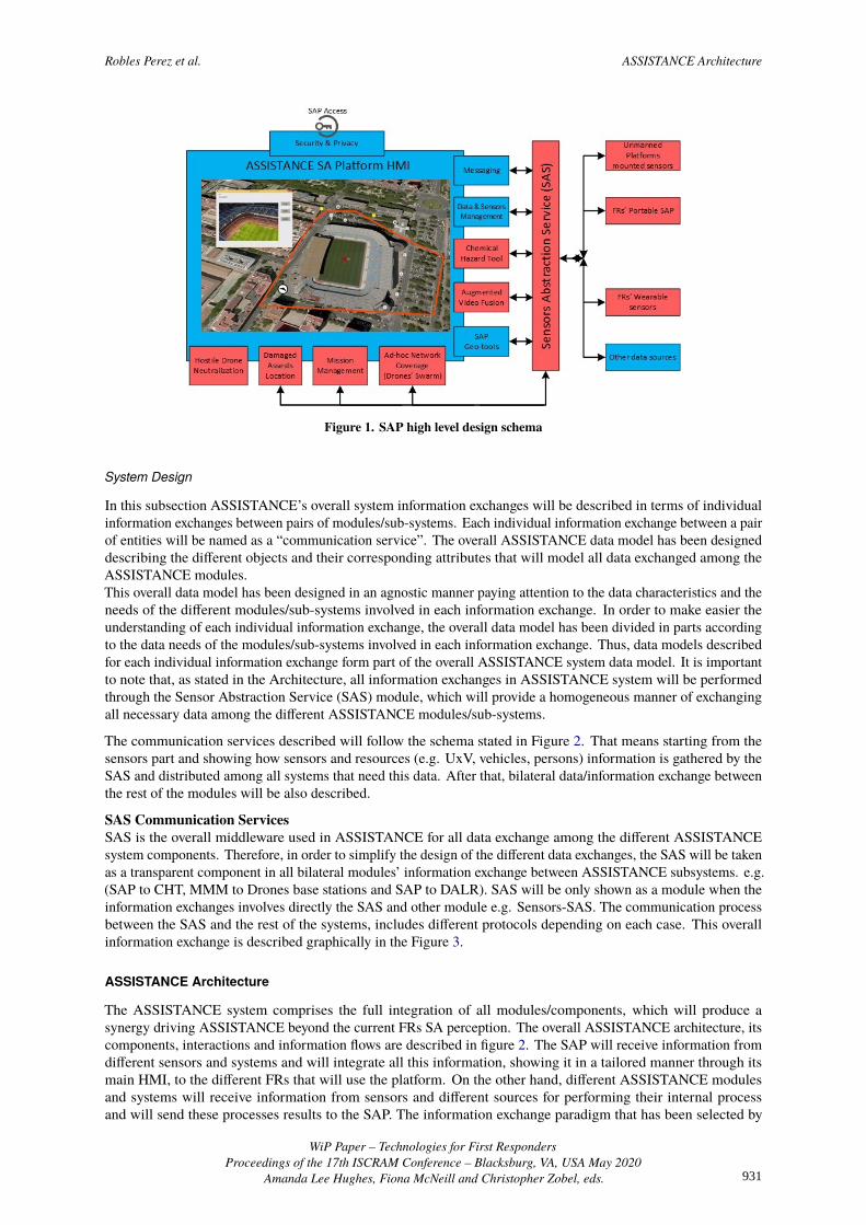
SAP core will be adapted based on the civil version of the Spanish Army Friendly Force Tracking (SIMACET-FFT)system developed by UPV partner, and currently deployed in several international missions. This system is acomplete SA solution capable of integrating a wide range of sensors and o�ering advanced SA and Command andControl (C2) capabilities. ASSISTANCE will use some of these preexisting SA capabilities in its core platform,which will be tailored and updated during the project. In addition, innovative SA modules/capabilities will bedeveloped for being integrated in this core platform in order to build the whole ASSISTANCE SA platform. SAPhigh level design schema is shown in Figure 1. The existing modules included in the core application are depictedin blue color and the new ones that will be developed during the project in red color. The information represented inthe SA Platform HMI will change depending on the active function mode selected, which will be associated to theinformation needs of each concrete type of FRs organizations (e.g. firefighters, LEAs, medical sta�) according totheir expressed needs.
WiP Paper – Technologies for First RespondersProceedings of the 17th ISCRAM Conference – Blacksburg, VA, USA May 2020
Amanda Lee Hughes, Fiona McNeill and Christopher Zobel, eds. 930
Robles Perez et al. ASSISTANCE Architecture
Figure 1. SAP high level design schema
System Design
In this subsection ASSISTANCE’s overall system information exchanges will be described in terms of individualinformation exchanges between pairs of modules/sub-systems. Each individual information exchange between a pairof entities will be named as a “communication service”. The overall ASSISTANCE data model has been designeddescribing the di�erent objects and their corresponding attributes that will model all data exchanged among theASSISTANCE modules.This overall data model has been designed in an agnostic manner paying attention to the data characteristics and theneeds of the di�erent modules/sub-systems involved in each information exchange. In order to make easier theunderstanding of each individual information exchange, the overall data model has been divided in parts accordingto the data needs of the modules/sub-systems involved in each information exchange. Thus, data models describedfor each individual information exchange form part of the overall ASSISTANCE system data model. It is importantto note that, as stated in the Architecture, all information exchanges in ASSISTANCE system will be performedthrough the Sensor Abstraction Service (SAS) module, which will provide a homogeneous manner of exchangingall necessary data among the di�erent ASSISTANCE modules/sub-systems.
The communication services described will follow the schema stated in Figure 2. That means starting from thesensors part and showing how sensors and resources (e.g. UxV, vehicles, persons) information is gathered by theSAS and distributed among all systems that need this data. After that, bilateral data/information exchange betweenthe rest of the modules will be also described.
SAS Communication ServicesSAS is the overall middleware used in ASSISTANCE for all data exchange among the di�erent ASSISTANCEsystem components. Therefore, in order to simplify the design of the di�erent data exchanges, the SAS will be takenas a transparent component in all bilateral modules’ information exchange between ASSISTANCE subsystems. e.g.(SAP to CHT, MMM to Drones base stations and SAP to DALR). SAS will be only shown as a module when theinformation exchanges involves directly the SAS and other module e.g. Sensors-SAS. The communication processbetween the SAS and the rest of the systems, includes di�erent protocols depending on each case. This overallinformation exchange is described graphically in the Figure 3.
ASSISTANCE Architecture
The ASSISTANCE system comprises the full integration of all modules/components, which will produce asynergy driving ASSISTANCE beyond the current FRs SA perception. The overall ASSISTANCE architecture, itscomponents, interactions and information flows are described in figure 2. The SAP will receive information fromdi�erent sensors and systems and will integrate all this information, showing it in a tailored manner through itsmain HMI, to the di�erent FRs that will use the platform. On the other hand, di�erent ASSISTANCE modulesand systems will receive information from sensors and di�erent sources for performing their internal processand will send these processes results to the SAP. The information exchange paradigm that has been selected by
WiP Paper – Technologies for First RespondersProceedings of the 17th ISCRAM Conference – Blacksburg, VA, USA May 2020
Amanda Lee Hughes, Fiona McNeill and Christopher Zobel, eds. 931

Robles Perez et al. ASSISTANCE Architecture
Figure 2. ASSISTANCE Architecture Schema
Figure 3. Modules involved in the SAS communication process
WiP Paper – Technologies for First RespondersProceedings of the 17th ISCRAM Conference – Blacksburg, VA, USA May 2020
Amanda Lee Hughes, Fiona McNeill and Christopher Zobel, eds. 932

Robles Perez et al. ASSISTANCE Architecture
Figure 4. Data model of the information o�ered by SAS related to sensors, drones and units deployed
ASSISTANCE for the di�erent modules and systems integration is a publish/subscribe approach performed throughthe SAS. Micro services architecture has been chosen because its simplicity, its improved productivity, and becauseit is also autonomous and scalable (Uckelmann et al. 2011). The data from sensors will be collected through a secureMQTT version protocol (Chien et al. 2019; Singh et al. 2015) directly from the sensors, then data will be publishedto the SAS or to any subsystem subscribed to the publish/subscribe MQTT topic protocol of the sensor. Once insidethe SAS data will be shared to the di�erent subsystems using several technologies cited as follow: Web sockets(Reddy et al. 2019), Distributional Di�erential Privacy (DDP) or Network Address Translation (NATS) (Frew et al.2008) protocol, that allows publishing in real-time to a web site as it uses the publish-subscribe messaging pattern.
SAS Data Model
SAS data model, could be inferred from figure 4 Where the central element is the Mission, that can have n resourcessuch as a vehicle, unit or unmanned vehicle, which will acquire field data from the sensors, acting as an abstractionlayer.
SAS Data Collection
The Data Collection System (DCS) connects the available sensors using the MQTT protocol by means of asubscription to the topic of each sensor. DCS will gather the data from each sensor each time the data changesand will store the data in the SAS database and then all systems subscribed to these data will receive this updatedinformation.
SAS Data Delivery System
The Data Delivery System (DDS) is the part of the SAS in charge of sending the information to all modules/subsystemsubscribed or on demand. The subscription will be performed through real-time Web Socket using DDP or NATSreal time server, these two technologies have been chosen because they are complementary.
SAS Data Inputs and Outputs
Also according to Figure 2, SAS will receive all information from the sensors stated in the system and will publishit in a standard manner for being processed by the di�erent ASSISTANCE modules/systems subscribed to thecorresponding real-time Web Socket DDP/NATS or API REST methods.
WiP Paper – Technologies for First RespondersProceedings of the 17th ISCRAM Conference – Blacksburg, VA, USA May 2020
Amanda Lee Hughes, Fiona McNeill and Christopher Zobel, eds. 933
Robles Perez et al. ASSISTANCE Architecture
ASSISTANCE NETWORK LAYER
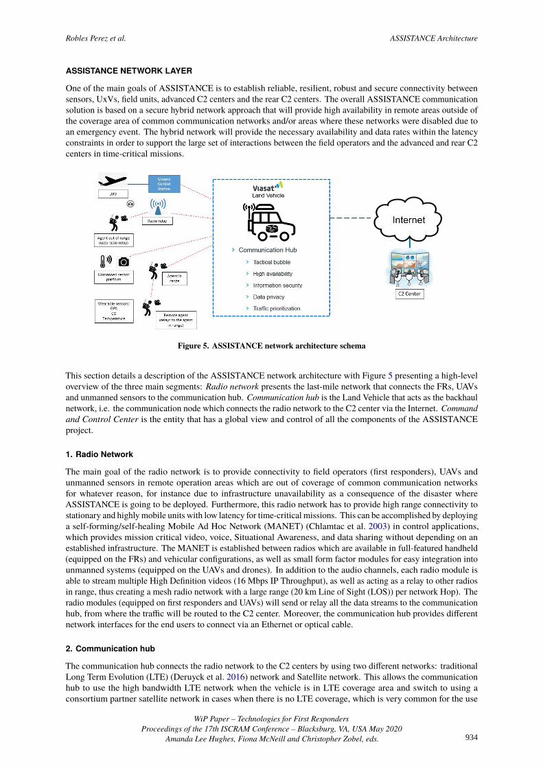
One of the main goals of ASSISTANCE is to establish reliable, resilient, robust and secure connectivity betweensensors, UxVs, field units, advanced C2 centers and the rear C2 centers. The overall ASSISTANCE communicationsolution is based on a secure hybrid network approach that will provide high availability in remote areas outside ofthe coverage area of common communication networks and/or areas where these networks were disabled due toan emergency event. The hybrid network will provide the necessary availability and data rates within the latencyconstraints in order to support the large set of interactions between the field operators and the advanced and rear C2centers in time-critical missions.
Figure 5. ASSISTANCE network architecture schema
This section details a description of the ASSISTANCE network architecture with Figure 5 presenting a high-leveloverview of the three main segments: Radio network presents the last-mile network that connects the FRs, UAVsand unmanned sensors to the communication hub. Communication hub is the Land Vehicle that acts as the backhaulnetwork, i.e. the communication node which connects the radio network to the C2 center via the Internet. Commandand Control Center is the entity that has a global view and control of all the components of the ASSISTANCEproject.
1. Radio Network
The main goal of the radio network is to provide connectivity to field operators (first responders), UAVs andunmanned sensors in remote operation areas which are out of coverage of common communication networksfor whatever reason, for instance due to infrastructure unavailability as a consequence of the disaster whereASSISTANCE is going to be deployed. Furthermore, this radio network has to provide high range connectivity tostationary and highly mobile units with low latency for time-critical missions. This can be accomplished by deployinga self-forming/self-healing Mobile Ad Hoc Network (MANET) (Chlamtac et al. 2003) in control applications,which provides mission critical video, voice, Situational Awareness, and data sharing without depending on anestablished infrastructure. The MANET is established between radios which are available in full-featured handheld(equipped on the FRs) and vehicular configurations, as well as small form factor modules for easy integration intounmanned systems (equipped on the UAVs and drones). In addition to the audio channels, each radio module isable to stream multiple High Definition videos (16 Mbps IP Throughput), as well as acting as a relay to other radiosin range, thus creating a mesh radio network with a large range (20 km Line of Sight (LOS)) per network Hop). Theradio modules (equipped on first responders and UAVs) will send or relay all the data streams to the communicationhub, from where the tra�c will be routed to the C2 center. Moreover, the communication hub provides di�erentnetwork interfaces for the end users to connect via an Ethernet or optical cable.
2. Communication hub
The communication hub connects the radio network to the C2 centers by using two di�erent networks: traditionalLong Term Evolution (LTE) (Deruyck et al. 2016) network and Satellite network. This allows the communicationhub to use the high bandwidth LTE network when the vehicle is in LTE coverage area and switch to using aconsortium partner satellite network in cases when there is no LTE coverage, which is very common for the use
WiP Paper – Technologies for First RespondersProceedings of the 17th ISCRAM Conference – Blacksburg, VA, USA May 2020
Amanda Lee Hughes, Fiona McNeill and Christopher Zobel, eds. 934

Robles Perez et al. ASSISTANCE Architecture
Figure 6. Detailed schema of the ASSISTANCE network architecture
cases in the ASSISTANCE project. Thus, providing high reliability and availability even in rough terrains andchanging conditions. Figure 6 illustrates a detailed schema of the ASSISTANCE network architecture.
Link failover In order to ensure reliability and availability in di�erent network scenarios, two separate VPNtunnels (one over LTE and the other over the Satellite link) will be established between the Link Balancing Uniton-board the communication hub (vehicle) and the VPN concentrator hosted in a Virtual Private Cloud (VPC)which terminates the VPN tunnels. The Link Balancing Unit and VPN concentrator manage the VPN tunnels inorder to provide Active/Standby failover between the two links (LTE and Satellite). The VPN tunnels act as asingle logical VPN tunnel by performing packet-based fail-over between the links. This means that the establishedsessions are maintained in the case of a link failure and don’t need to be re-established (stateful failover).
3. C2 Centers
In the ASSISTANCE pilots’ deployments there will be two di�erent kinds of C2 centers, the advanced C2 centerand the rear C2 center. The advanced C2 center will be deployed on field and it can be composed by one or severallaptops that directly take information from sensors deployed on field and use this information for taking tacticaldecisions and also for protecting the units deployed on field. It is possible that di�erent kinds of FRs have their ownadvanced C2 center on field. The rear C2 center is the entity that has a global view and control of all the componentsof the ASSISTANCE system which means that it is crucial that the data exchange complies with strict security andlatency requirements. This can be achieved by establishing and end-to-end VPN connection between the C2 centerand the communication hub. Each ASSISTANCE partner can establish a VPN to the VPC which will enable thebidirectional data exchange with the ASSISTANCE remote components (field operators, UAVs, sensors).
CONCLUSION
In this wiP paper we have reviewed how ASSISTANCE will preserve FRs as well as will enhance their SA duringdisaster mitigation, in a wide range of use-cases, even in remote areas or through a commercial networks failure, dueto the novel architecture and mechanisms proposed. It has been stated a system architecture for ongoing disaster thatfacilitates with a tailored SAP which supports FRs management depending on each organization needs, reflectingthe real state of the event over the integration of new paradigms, tools and technologies.
ASSISTANCE is fully oriented to validate its capabilities in real scenarios, approaching real use-case with similarpilots, testing the overall system capabilities by the FRs consortium partners. First Responders’ on field feedbackwill allow the consortium to correct potential technical errors in order to improve the system for the final projectpilot demonstration and a future paper with tangible results.
ACKNOWLEDGMENTS
ASSISTANCE is funded by the Horizon 2020 Program of the European Commission, in the topic of CriticalInfrastructure Protection, grant agreement 832576.
REFERENCES
ALADDIN (2017-2020). H2020 ALADIN, Advanced hoListic Adverse Drone Detection, Identification & Neutral-ization. https://aladdin2020.eu/.
WiP Paper – Technologies for First RespondersProceedings of the 17th ISCRAM Conference – Blacksburg, VA, USA May 2020
Amanda Lee Hughes, Fiona McNeill and Christopher Zobel, eds. 935

Robles Perez et al. ASSISTANCE Architecture
Alexander, D. E. (2015). “Disaster and emergency planning for preparedness, response, and recovery”. In: OxfordUniversity Press.
Amarasingham, A. (2019). “Terrorism on the Teardrop Island: Understanding the Easter 2019 attacks in Sri Lanka”.In: CTC Sentinel 12.5.
Bisarya, R. and Puri, S. (2005). “The Bhopal gas tragedy—a perspective”. In: Journal of Loss Prevention in theProcess Industries 18.4-6, pp. 209–212.
Chien, H.-Y., Kou, X.-A., Chiang, M.-L., and Su, C. (2019). “Secure and e�cient MQTT group communicationdesign”. In: International Conference on Computational Science/Intelligence & Applied Informatics. Springer,pp. 177–186.
Chlamtac, I., Conti, M., and Liu, J. J.-N. (2003). “Mobile ad hoc networking: imperatives and challenges”. In: Adhoc networks 1.1, pp. 13–64.
Coburn, A. and Spence, R. (2003). Earthquake protection. John Wiley & Sons.CommandX (n.d.). http://www.eurocommand.com/en/comprehensive- solutions/commandx- all-inclusive.php.
Deruyck, M., Wyckmans, J., Martens, L., and Joseph, W. (2016). “Emergency ad-hoc networks by using dronemounted base stations for a disaster scenario”. In: 2016 IEEE 12th International Conference on Wireless andMobile Computing, Networking and Communications (WiMob). IEEE, pp. 1–7.
DragonForce DRAKONTAS (n.d.). https://www.drakontas.com/index.php/dragonforce/.ESRI (n.d.). https://www.esri.com/es-es/home.Frew, E. W., Dixon, C., Elston, J., Argrow, B., and Brown, T. X. (2008). “Networked communication, command, and
control of an unmanned aircraft system”. In: Journal of aerospace computing, information, and communication5.4, pp. 84–107.
Homeland Security, D. of (2016). FiRST, First Responder Support Tools. https://www.dhs.gov/publication/first-responder-support-tools-first-application.
ICARUS (2012-2016). FP7 ICARUS, Integrated Components for Assisted Rescue and Unmanned Search operations.http://www.fp7-icarus.eu/.
IMPACT (n.d.). https://geo.ornl.gov/impact/index.html.Impact Examples (n.d.). https://geo.ornl.gov/impact/docs/IMPACT_Examples.pdf.Labaka, L., Hernantes, J., Laugé, A., and Sarriegi, J. M. (2013). “Enhancing resilience: implementing resilience
building policies against major industrial accidents”. In: International Journal of Critical Infrastructures 6 9.1-2,pp. 130–147.
Mirbabaie, M., Bunker, D., Deubel, A., and Stieglitz, S. (2018). “Examining convergence behaviour during crisissituations in social media-a case study on the manchester bombing 2017”. In: International Working Conferenceon Transfer and Di�usion of IT. Springer, pp. 60–75.
MQTT (n.d.). http://mqtt.org/.Reddy, P. B., Reddy, A., Reddy, V. V., Sarath, C. S., and Manikandan, K. (2019). “Real-time monitoring system
(websocket-based) for remote intelligent buildings”. In:Shrestha, B. and Pathranarakul, P. (2018). “Nepal Government’s Emergency Response to the 2015 Earthquake: A
Case Study”. In: Social Sciences 7.8, p. 127.Singh, M., Rajan, M., Shivraj, V., and Balamuralidhar, P. (2015). “Secure mqtt for internet of things (iot)”. In: 2015
Fifth International Conference on Communication Systems and Network Technologies. IEEE, pp. 746–751.Uckelmann, D., Harrison, M., and Michahelles, F. (2011). “An architectural approach towards the future internet of
things”. In: Architecting the internet of things. Springer, pp. 1–24.
WiP Paper – Technologies for First RespondersProceedings of the 17th ISCRAM Conference – Blacksburg, VA, USA May 2020
Amanda Lee Hughes, Fiona McNeill and Christopher Zobel, eds. 936