sveconorwegian igneous complexes beneath the … · sveconorwegian igneous complexes beneath the...
TRANSCRIPT

www.elsevier.com/locate/tecto
Tectonophysics 387 (
Sveconorwegian igneous complexes beneath
the Norwegian–Danish Basin
Odleiv Olesena,*, Mark A. Smethursta, Trond H. Torsvika, Torben Bidstrupb
aGeological Survey of Norway, Leif Eirikssons vei 39, N-7491 Trondheim, NorwaybGeological Survey of Denmark and Greenland, Thoravej 8, DK-2400 Kbbenhavn NV, Denmark
Received 12 November 2002; accepted 8 June 2004
Abstract
Gravity and magnetic anomalies have previously been interpreted to indicate strongly magnetic Permian or even Tertiary
intrusive bodies beneath the Skagerrak waterway (such as the dSkagerrak volcanoT) and beneath Silkeborg in Denmark. Our
combined modelling of the magnetic and gravity anomalies over these rock bodies indicates that a steep upward magnetisation is
required to explain the magnetic anomalies at the surface, reminiscent of the magnetic direction in the Sveconorwegian rocks of
the Rogaland Igneous Province in southern Norway. The younger rocks of the Permian Oslo Rift region have intermediate and
flat magnetisation that is inadequate to explain the observed magnetic field. The positive part of the Skagerrak aeromagnetic
anomaly is continuous with the induced anomalies associated with the eastward extension of the Rogaland Igneous Province.
This relation also suggests that rocks of the Rogaland Igneous Province and its offshore extension are responsible for the
Skagerrak anomalies. Both the negative, remanence-dominated aeromagnetic anomaly and the positive gravity anomaly can be
modelled using constraints from seismic reflection lines and available density data and rock-magnetic properties. A 7 km thick
complex of ultramafic/mafic intrusions is located below a southward dipping 1–4 km thick section of Mesozoic sediments and 1–
2 km of Palaeozoic sediments. The enormous body of dense, ultramafic/mafic rocks implied by the modelling could be the
residue of the parental magma that produced the voluminous Rogaland anorthosites. The application of similar petrophysical
properties in the forward modelling of the Silkeborg source body provides an improved explanation of the observed gravity and
magnetic anomalies compared with earlier studies. The new model is constrained by magnetic depth estimates (from the Located
Euler method) ranging between 6 and 8 km. Forward modelling shows that a model with a reverse magnetic body (anorthosite?)
situated above a dense, mafic/ultramafic body may account for the Silkeborg anomalies. The anorthosites may have formed by
differentiation of the underlying mafic intrusion, similar to the intrusive relations in the Rogaland Igneous Province. We conclude
that there is strong evidence for a Sveconorwegian age for both the Skagerrak and the Silkeborg anomalous rock bodies.
D 2004 Elsevier B.V. All rights reserved.
Keywords: Gravity; Magnetic; Potential field modelling; Sveconorwegian; Crustal structure; Magmatic intrusions
0040-1951/$ - s
doi:10.1016/j.tec
* Correspon
E-mail addre
2004) 105–130
ee front matter D 2004 Elsevier B.V. All rights reserved.
to.2004.06.009
ding author. Fax: +47 7390 4494.
sses: [email protected] (O. Olesen)[email protected] (M.A. Smethurst)8 [email protected] (T.H. Torsvik)8
Bidstrup).
O. Olesen et al. / Tectonophysics 387 (2004) 105–130106
1. Introduction
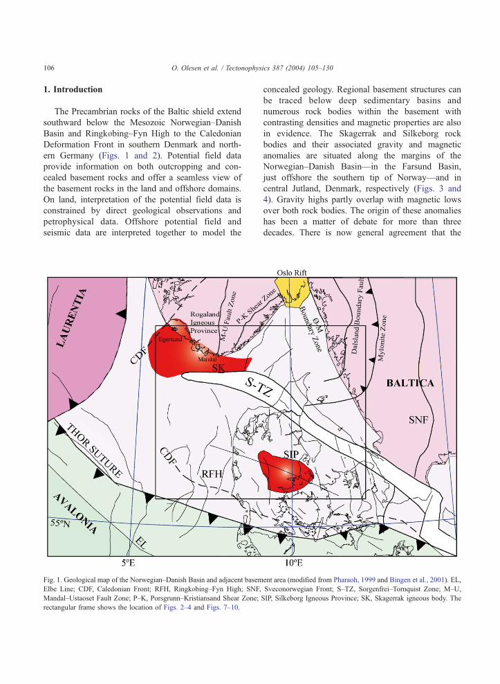
The Precambrian rocks of the Baltic shield extend
southward below the Mesozoic Norwegian–Danish
Basin and Ringkbbing–Fyn High to the Caledonian
Deformation Front in southern Denmark and north-
ern Germany (Figs. 1 and 2). Potential field data
provide information on both outcropping and con-
cealed basement rocks and offer a seamless view of
the basement rocks in the land and offshore domains.
On land, interpretation of the potential field data is
constrained by direct geological observations and
petrophysical data. Offshore potential field and
seismic data are interpreted together to model the
Fig. 1. Geological map of the Norwegian–Danish Basin and adjacent basem
Elbe Line; CDF, Caledonian Front; RFH, Ringkbbing–Fyn High; SNF,
Mandal–Ustaoset Fault Zone; P–K, Porsgrunn–Kristiansand Shear Zone;
rectangular frame shows the location of Figs. 2–4 and Figs. 7–10.
concealed geology. Regional basement structures can
be traced below deep sedimentary basins and
numerous rock bodies within the basement with
contrasting densities and magnetic properties are also
in evidence. The Skagerrak and Silkeborg rock
bodies and their associated gravity and magnetic
anomalies are situated along the margins of the
Norwegian–Danish Basin—in the Farsund Basin,
just offshore the southern tip of Norway—and in
central Jutland, Denmark, respectively (Figs. 3 and
4). Gravity highs partly overlap with magnetic lows
over both rock bodies. The origin of these anomalies
has been a matter of debate for more than three
decades. There is now general agreement that the
ent area (modified from Pharaoh, 1999 and Bingen et al., 2001). EL,
Sveconorwegian Front; S–TZ, Sorgenfrei–Tornquist Zone; M–U,
SIP, Silkeborg Igneous Province; SK, Skagerrak igneous body. The

Fig. 2. Compilation of topography/bathymetry southwestern Scandinavia. Structural elements at top pre-Zechstein level (Vejbæk and Britze,
1994) are included as well as the SKAG-86-07 and Silkeborg interpretation profiles. The grey line shows the border between the offshore
national sectors.
O. Olesen et al. / Tectonophysics 387 (2004) 105–130 107
sources of the anomalies are igneous bodies. Some
authors advocate a Permian age for the bodies
(Sharma, 1970; Am, 1973; Abrahamsen and Madir-
azza, 1986; Thybo and Schonharting, 1991; Berthel-
sen, 1992; Thybo, 1997, 2000; Strykowski, 2000),
while others propose a Tertiary age for the so-called
dSkagerrak volcanoT (Sharma, 1970; Am, 1973;
Hovland, 1987). A Tertiary age is supported by the
presence of Eocene ashes in northern Jutland
(Sharma, 1970) and the steep inclination of the
inferred remanent magnetisation of the source rock
body. Jensen and Langnes (1992) questioned the
Tertiary age of the intrusion. Nevertheless, the
proximity of the rock bodies to the Permian Oslo
Rift and the Late Carboniferous Scania dyke swarm
has lead most researchers to accept a Permo-Carbon-
iferous intrusive origin for these subsurface features.
Similar negative magnetic anomalies occurring on
the mainland of Norway are, however, caused by
Sveconorwegian intrusions. This enigma calls for a
renewed interpretation of the potential field data sets
in the region to try to distinguish magnetic anomalies

Fig. 3. Total magnetic field anomaly map of southwestern Scandinavia. The contour interval is 50 nT. List of compiled datasets is shown in
Table 1. Magnetic anomalies: BA, Bamble; BB, Bulbjerg Block; BH, Bohus; D-1, D-1 well; IB-1, Ibenholt-1 well; LD, Lyngdal; RL, Rogaland;
SB, Silkeborg; SK, Skagerrak anomaly; VB, Varberg. The diagonal, white hatching indicates the areal extent of the Rogaland Igneous Province.
Blue lines indicate regional basement structures. Interpreted age of anomaly sources: P, Permian; S, Sveconorwegian; ?, unidentified. The five
wells, 10/5-1, FR-1, IB-1, GR-1 and JE-1 are penetrating Precambrian basement and are shown with filled circles. The grey line shows the
border between the offshore national sectors.
O. Olesen et al. / Tectonophysics 387 (2004) 105–130108
related to the Proterozoic basement from those
caused by younger Permian igneous bodies.
2. Main structural elements
Fig. 2 shows the Skagerrak–Kattegat Platform,
the Norwegian–Danish Basin and the Ringkbbing–Fyn High. The main structural elements in the
adjacent basement north and east of the Norwegian–
Danish Basin are the N–S trending Mandal–Ustaoset
Fault Zone (MUFZ in Fig. 1; Sigmond, 1985) and
the NE–SW trending Porsgrunn–Kristiansand Shear
Zone (PKSZ in Fig. 1; Starmer, 1991) in mainland
Norway and the N–S trending Dalsland Boundary
Fault (Fig. 1; Berthelsen, 1977) in Sweden. Igneous
provinces within the area are the Upper Carbon-
iferous–Permian (c. 300–245 Ma) Oslo Rift in the

Fig. 4. Bouguer gravity map of southwestern Scandinavia based on a compilation of data sets from the mainland (Table 2) and 40,000 km of
marine gravity profiles collected by the Norwegian Petroleum Directorate, Mobil Exploration, Statoil and the Norwegian Mapping Authority.
The contour interval is 2.5�10�5 m/s2 (mgal). Gravity anomalies: BH, Bohus; RL, Rogaland; SB, Silkeborg; SK, Skagerrak. Interpreted age of
anomaly sources: P, Permian; S, Sveconorwegian; ?, unidentified. The five wells, 10/5-1, FR-1, IB-1, GR-1 and JE-1 are penetrating
Precambrian basement and are shown with filled circles. The grey line shows the border between the offshore national sectors.
O. Olesen et al. / Tectonophysics 387 (2004) 105–130 109
northeast (Fig. 1; Ramberg, 1976; Neumann et al.,
1992; Olaussen et al., 1994; Sundvoll and Larsen,
1994) and the Sveconorwegian (c. 930 Ma) Roga-
land Igneous Province (Fig. 1; Duchesne et al.,
1987) in the northwest. The Oslo Rift is dominated
by intermediate and acidic intrusive rocks and the
Rogaland Igneous Province comprises a wide range
of norites, anorthosites, granodiorites and granites.
The latter complex is often referred to as an
anorthosites–mangerite–charnockite–granite (AMCG)
suite.
The Trans-European Suture Zone (TESZ) has a
long history (see review in Pharaoh, 1999), and its
early development includes the amalgamation of
Avalonia and Baltica along the Thor Suture (Fig.
1). Late Ordovician suturing between these two
plates eliminated the Tornquist Sea that had
separated these palaeocontinents during most of

O. Olesen et al. / Tectonophysics 387 (2004) 105–130110
the Ordovician (see reviews in Cocks and Torsvik,
2002; Torsvik and Rehnstrom, 2003). The Caledo-
nian Deformation Front to the south of the Ring-
kbbing–Fyn High (CDF in Fig. 1) constitutes the
nappe front between Baltica and Avalonia (Berthel-
sen, 1992; Abramovitz et al., 1998; Thybo, 2001).
The Sorgenfrei–Tornquist Zone (S–TZ in Fig. 1)
forms part of the TESZ and is a complex tectonic zone
forming the northwestern part of the Tornquist–
Teisseyre Lineament, one of the major European
tectonic sutures (Liboriussen et al., 1987). The
Sorgenfrei–Tornquist Zone (S–TZ) lies north of the
older Thor Suture and separates the Skagerrak–
Kattegat Platform from the Norwegian–Danish Basin.
The S–TZ was mostly active during late Palaeozoic
and Mesozoic times (Liboriussen et al., 1987;
Mogensen, 1994; Pegrum, 1984; Mogensen and
Jensen, 1994) and curvilinear faults and rift basins
were formed during this tectonic phase. The main
structures bordering the northwestern segment of the
Sorgenfrei–Tornquist Zone are the Bbrglum Fault to
the northeast and the Fjerritslev Trough and the
Bulberg Block to the southwest. The formation of
the Permo-Carboniferous Oslo Rift system (including
the Skagerrak Graben and the Oslo Graben) to the
northeast represents a reactivation of a Sveconorwe-
gian structure and is closely linked to dextral strike–
slip movements along the Sorgenfrei–Tornquist Zone
(Ro et al., 1990; Sundvoll and Larsen, 1994; Lie,
1995). Extensive volcanic activity was associated with
this tectonism around the Oslo Rift and around the
Sorgenfrei–Tornquist Zone in Scania (Neumann et al.,
1992; Klingspor, 1976). The subsequent thermal
relaxation may have initiated the late Palaeozoic and
Mesozoic subsidence of the Norwegian–Danish Basin
(Sørensen, 1986). The Norwegian–Danish Basin is, to
a large extent, dominated by salt-related tectonics
(Sørensen et al., 1992; Vejbæk and Britze, 1994).
Table 1
Aeromagnetic surveys compiled for the present study (Fig. 3)
Year Contractor Area Fligh
1996 NGU Skagerrak-North Sea (SAS-96) 140 m
1959–71 NGU Southern Norway 150–
1969–93 SGU Bohusl7n, Sweden 30 m
1965 Hunting Surveys Jutland, Denmark 750 m
1970–71 Fairey Surveys Kattegat, Sweden 600 m
a.g., above ground; a.m.s.l., above mean sea level; NGU, Geological Sur
3. Geophysical data sets
We have produced new compilations of aeromag-
netic and gravity data for the Norwegian–Danish
Basin and adjacent areas in Denmark, Norway and
Sweden. High-sensitivity aeromagnetic data acquired
during the summer of 1996 in Danish, Norwegian
and Swedish waters of the Skagerrak (Olesen et al.,
1996, 1997) and four vintage aeromagnetic surveys
(Table 1) have been compiled. The combined dataset
is displayed in Fig. 3 using shaded relief and
histogram–equalisation techniques. The Swedish data
from the Bohusl7n area were upward continued from
30 to 150 m and resampled from 200�200 to
500�500 m cells. The aeromagnetic data from
northern and central Jutland in the form of hand-
contoured maps were digitised by the Geological
Survey of Denmark and Greenland (GEUS) and
were gridded to a 500�500 m grid. The Kattegat
data had previously been digitised to a 4�4-km grid
by the European Geotraverse Project (Wonik et al.,
1992). Manually drawn aeromagnetic contour maps
at a scale of 1:50,000 of mainland Norway have
earlier been digitised into a 500�500-m matrix and
the Definite Geomagnetic Reference Field 1965 has
been subtracted (Nor. geol. unders., 1992). Grids
from the different data sets were merged with the
SAS-96 data using a minimum curvature algorithm,
GRIDSTITCH, developed by Desmond Fitzgerald
and Associates (1996). The new 500�500 m grid
represents a significant improvement compared to
the previous 5�5 km grid of the European Geo-
traverse Project (Wonik et al., 1992). Studies of the
depth to magnetic basement from the latter coarse
grid will (upward, continued to 3000 m) not give
reliable depth estimates in the range of 0–3 km.
The gravity grid in Fig. 4 is based on a compilation
of 3614 gravity stations (Table 2) on the mainland of
t altitude Line spacing Tie-line spacing Recording
a.m.s.l. 2 km 5 km digital
300 m a.g. 500–1000 m analogue
a.g. 200 m analogue–digital
a.m.s.l. 3–6 km 12 km analogue
a.m.s.l. 4 km 20–30 km analogue
vey of Norway; SGU, Geological Survey of Sweden.

Table 3
Density of basement rocks from the coastal area of southern Norway
and western Sweden, Bohusl7n
Location Rock type No. Density
(kg/m3)
Reference
Egersund
area
Gneiss N/A 2700 Smithson and
Ramberg, 1979
Flekkefjord
area
Gneiss 287 2690 Balling and
Falkum, 1975
Mandal area Gneiss 37 2730 Smithson and
Barth, 1967
Telemark area Gneiss, etc. 36 2760 Smithson, 1963
Bamble Gneiss, etc. 54 2810 Smithson, 1963
Bamble Gneiss 166 2734 Sindre, 1992
Skien-Gvarv Gneiss, etc. 29 2680 Ramberg, 1976
astfold Gneiss 42 2660 Lind and Saxov,
1970
astfold Gneiss 61 2750 Ramberg and
Smithson, 1971
Bohusl7n Gneiss 20 2730 Lind, 1967
Egersund
area
Norite N/A 3000 Smithson and
Ramberg, 1979
Egersund
area
Norite 86 3090 McEnroe et al.,
1996
Representative rock units are selected from the area. Density data
from the Egersund Igneous Province and the Herefoss, Grimstad
and Iddefjord granite complexes (Bingen et al., 2001) are excluded
in the compilation of the dnormalT density of the Precambrian
basement.
O. Olesen et al. / Tectonophysics 387 (2004) 105–130 111
Sweden and Norway collected by NGU, SGU, SK
(Norwegian Mapping Authority) and Balling and
Falkum (1975), and approximately 40,000 km of
marine gravity profiles collected by the Norwegian
Petroleum Directorate, ExxonMobil, Statoil and the
Norwegian Mapping Authority (Skilbrei et al., 2000).
The marine data sets were compiled by TGS–Nopec.
Gravity data on mainland Denmark were digitised
from hand-contoured maps by GEUS. The complete
Bouguer reduction of the gravity data was computed
using a rock density of 2670 kg/m3 on mainland
Norway and Sweden and 2000 kg/m3 on mainland
Denmark. The spacing between the gravity stations
varies in most of the on land areas between 1 and 3
km. A simple Bouguer correction was carried out on
the marine gravity measurements using a density of
2200 kg/m3. The International Gravity Standardisa-
tion Net 1971 (IGSN 71) and the Gravity Formula
1980 for normal gravity were used to level the
surveys. The combined data set was interpolated to
a square grid of 2�2 km using the minimum curvature
method (Swain, 1976).
Some of the magnetic and gravimetric anomalies are
continuous from land on to the continental shelf. It is
therefore important to know the density and magnetic
properties of the rocks on land when interpreting
potential field data covering offshore areas. NGU has
Table 2
On land gravity data from NGU, GEUS, LMV, SGU, SK and the
Universities of Oslo and 2rhus compiled in the present project
(Fig. 4)
Area No. Institution Reference
Bohusl7n 232 Geological Survey
of Sweden (SGU)
Bohusl7n 541 Swedish Mapping
Authority (LMV)
Southern
Norway
261 Norwegian Mapping
Authority (SK)
Skilbrei et al.,
2000
Agder-
Rogaland
773 Geological Survey of
Norway (NGU)
Sindre, 1993
Grimstad and
Herefoss
173 University of Oslo Smithson, 1963
Agder 1637 University of 2rhus Balling and
Falkum, 1975
Denmark * Geological Survey of
Denmark and
Greenland (GEUS)
(*), digitised hand-contoured maps.
earlier carried out petrophysical sampling programmes
(for density, susceptibility and remanence measure-
ments) in the Arendal and Egersund areas (Sindre,
1992; McEnroe et al., 1996; 2001a). Rock density
studies (Table 3) from the nearby mainland, collected
during geological mapping and geophysical studies,
have earlier been published by other geophysicists
interpreting gravity data (Smithson, 1963; Lind, 1967;
Smithson and Barth, 1967; Lind and Saxov, 1970;
Ramberg and Smithson, 1971; Balling and Falkum,
1975; Ramberg, 1976; Smithson and Ramberg, 1979).
Representative rocks units (mainly gneisses) are
selected from the area. Density data from the Rogaland
Igneous Province and the Herefoss, Grimstad and
Iddefjord granite complexes (Bingen et al., 2001) are
excluded in the estimate of the general basement
density. The dnormalT density of the Precambrian
basement below the Norwegian–Danish Basin is
estimated to be 2730 kg/m3.
As further constraints for the gravity modelling, we
have used information from 10 petroleum exploration

Table 4
Density of sedimentary sequences from density logs of wells in the Norwegian–Danish Basin
Well No. L-1 D-1 Ibenholt-1 R-1 Inez-1 F-1 K-1 C-1 Felicia-1 J-1 Density
adapted for
modelling
Operator Chevron Gulf Phillips Chevron Chevron Gulf Chevron Gulf Statoil Gulf
Year 1970 1968 1987 1973 1977 1968 1970 1968 1987 1970
Structure Name Else Jane Ibenholt Kaye Inez Nina Lena Dora Felicia Lisa
Water depth 55 m 49 m 40 m 37 m 35 m 41 m 56 m 27 m 69 m 44 m 1.03
Start of log 1179 m 695 m 1134 m 1041 m 1023 m 755 957 m 1130 m 120 m 1026 m
Pleistocene
Post Chalk Goup 2.16 (2015) 2.06 (1205) 2.10 (1447) 2.15
Chalk Group 2.54 (2316) 2.47 (1462) 2.47 (1641) 2.24 (�1180) 2.43 (�1250) 2.28 (1283) – – 2.25 (712) 2.45
Lower Cretaceous 2.47 (2377) 2.29 (1511) 2.37 (1701) 2.30 (1262) 2.25 (1394) 2.23 (1511) 2.29 (1240) 2.27 (1286) 2.14 (905) 2.35
Jurassic 2.39 (2416) 2.23 (1543) 2.27 (1749) 2.35 (1303) 2.30 (1633) 2.33 (2041) 2.33 (1947) 2.18 (1373) 1.79 (1505) 2.41 (�1697) 2.35
Triassic 2.45 (2455) 2.41 (1687) 2.39 (1954) 2.29 (1998) 2.30 (1949+) 2.39
(2384+)
2.28
(2256+)
2.36 (2529) 2.42 (4695) 2.35 (1952+) 2.40
Zechstein Group, salt 2.86 (2553) 2.12 (3321) 2.06 (2141) – 2.08 (3034) 2.01 (5057) 2.05
Zechstein Gr., dolomite 2.80 (2491) 2.75 (3161) 2.67 (5134) 2.75
Rotliegende Group 2.67
(2671+)
2.46
(3528+)
2.38 (2533) 2.49
(2676+)
2.59 (3171+) 2.64 (5290) 2.60
Cambro-Silurian 2.78a
Precambrian basement 2.63 (2558+) 2.73b
Granitoid intrusive,
Silkeborg
2.70
Intermediate intrusive,
Silkeborg
2.80
Mafic intrusions, Skagerrak
and Silkdeborg
3.00c
Mantle 3.30
The estimates (*1000 kg/m3) are used for gravity modelling along the SKAG07 and Silkeborg profiles. Numbers in parentheses show depth in metres to the base of the different
sequences.a Density data from the Cambro-Silurian of the Oslo Region (31 samples, Ramberg, 1976).b Density data from the mainland Norway and Sweden (see Table 3) are included in the calculation of the mean basement density.c Density data from the Egersund area (see Table 3; Smithson and Ramberg, 1979).
O.Olesen
etal./Tecto
nophysics
387(2004)105–130
112

O. Olesen et al. / Tectonophysics 387 (2004) 105–130 113
wells in the Danish sector of the Norwegian–Danish
Basin. The densities of sedimentary sequences calcu-
lated from density logs are shown in Table 4. The
average values were used to constrain 2 1/2D
modelling along the SKAG-86-07 and Silkeborg
profiles.
Previous petrophysical studies have also docu-
mented that the Permian volcanics within the Oslo
Region are highly magnetic (Thorning and Abraham-
sen, 1980; Am and Oftedahl, 1977). Permian dykes/
basalts within the Oslo Rift and Permian dykes
within the Precambrian of southern Norway and
southwestern Sweden carry a viscous component
(close to the present earth field direction) and a
characteristically flat-lying remanent magnetisation
direction of probable Permian age (van Everdingen,
1960; Thorning and Abrahamsen, 1980; Torsvik et
al., 1998; in prep. and Table 5). The NRM directions
either point downwards (positive inclination) with
declination/inclination of 2108/308–808 or are rela-
tively flat lying with declination/inclination of 2008/�5–�308 (Fig. 5 and Table 5) depending on the
influence of the viscous component. The coercivity
force of the Permian flat-lying component is weak
and the median destructive field (MDF) in most rocks
is lower than 5 mT. Remanence directions carried by
Table 5
Magnetic properties of Permian and Proterozoic rocks from western Sweden
1980; McEnroe et al., 1996)
Rock type Age Location No. Sus. SI Rem.
mA/m
Basalt Permian Vestfold 42 0.067
Basalt Permian Skien 60 0.109
Diabase Permian Bohusl7n,Sweden
6 0.068 2200
Diabase Permian Tvedestrand 15 0.015 6500
Anorthosite Sveconorwegian 2na-Sira,Rogaland
0.003 5400
Norite Sveconorwegian Tellnes,
Rogaland
190 0.108 5000
Gneiss Sveconorwegian Bamble,
Telemark–Agder
76 0.030
Granite Sveconorwegian Bamble, Telemark–
Agder
13 0.040
Sus., susceptibility; mdf, median destructive field. A declination and inc
modelling of the magnetic Skagerrak and Silkeborg anomalies. The remane
0.05 SI, respectively. These parameters produce a ratio of remanent to ind
Sveconorwegian rocks in southern Norway (McEnroe
et al., 1996, 2001a) have steep, upward-pointing
NRM, i.e., negative inclination (Fig. 5). In the
Rogaland Igneous Province, 50 km to the NW of
the negative Skagerrak anomaly, there are numerous
Sveconorwegian (c. 930 Ma) intrusive bodies (Duch-
esne et al., 1987) that also carry an upward-directed
magnetisation, predominately anorthosites and norites
(Table 5). The Q-values (ratio of remanent to induced
magnetisation) range from 0.1 to 150 (McEnroe et al.,
1996, 2001a) and MDF ranging from 20 to 50 mT; the
anorthosites having both the highest Q-value and
coercivity. The Q-value of the anorthosites is con-
sequently 30–100 higher than for the Permian
diabases and basalts, while the coercivity is 10 times
higher. Hemo-ilmenite and titano-magnetite carry the
remanence in the Rogaland Igneous Province and
Permian volcanics, respectively (McEnroe et al.,
2001a; Thorning and Abrahamsen, 1980). Hemo-
ilmenite has been shown to be a more stable carrier of
remanence than titano-magnetite (McEnroe et al.,
2001b).
The remanence directions of the late Proterozoic
and Tertiary are both steep (negative or positive)
because Baltica was located at high southerly and
northerly latitudes, respectively, during these time
and southern Norway (Torsvik, in prep; Thorning and Abrahamsen,
int. Mdf
mT
Q-value NRM declination,
inclination
Reference
0.8 Am and Oftedahl, 1977
1.3 Am and Oftedahl, 1977
V5 0.7 183, 84 (n=7);
94, 87 (n=10);
181, �6 (n=9)
Thorning and
Abrahamsen, 1980
2.7 216, �27(n=15) Torsvik, in prep.
c50 77.1 – McEnroe et al., 2001a
20–50 7.3 293, �64 (n=32) McEnroe et al., 1996
Sindre, 1992
Sindre, 1992
lination of 2958 and �608, respectively, have been applied in the
nce intensity and susceptibility in the modelling are 5000 mA/m and
uced magnetisation (Q-value) of 2.55.

Fig. 5. Natural remanent magnetisation (NRM) of Permian diabases from the Oslo Region (Torsvik, in prep.) and Sveconorwegian norites and
anorthosites from the Rogaland Igneous Province (McEnroe et al., 1996).
O. Olesen et al. / Tectonophysics 387 (2004) 105–130114
periods (Fig. 6) and are therefore difficult to distin-
guish from each other. Late Proterozoic is therefore a
plausible alternative for the previously suggested
Tertiary age of the magnetisation in the Skagerrak
area.
Fig. 6. Palaeomagnetic plate reconstruction of Baltica through time. Sout
formation of the Rogaland Igneous Province and at a low northern latitude d
et al., 1999).
4. Depth to magnetic basement
The Euler 3-D deconvolution method (Thompson,
1982; Reid et al., 1990) was used to estimate the
depth to magnetic rocks within both the crystalline
hern Scandinavia was located at a high southern latitude during the
uring Permian time (modified from Torsvik et al., 1996; Walderhaug

O. Olesen et al. / Tectonophysics 387 (2004) 105–130 115
basement and the Palaeozoic intrasedimentary vol-
canics. The method has the advantage of being
applicable to anomalies caused by a wide variety
of geological structures and of being independent
of remanent magnetisation and ambient field
direction. The depths to the magnetic sources
constrain the interpretation of the Silkeborg and
Skagerrak anomalies and aid in the separation of
anomalies related to basement structures from
anomalies related to younger intrusions. Permian
Fig. 7. Depth to magnetic sources (Euler method) illustrated with coloured
1994) at top pre-Zechstein are included. Location and depth extent of exp
GR-1 and JE-1, penetrating Precambrian basement are shown with filled c
Bold black lines denote interpretation profiles.
volcanics in the Rotliegendes Group are somewhat
deeper than the top pre-Zechstein level but may be
difficult to separate from the deeper basement
sources. Depth estimates from potential field data
have been tested against both well and seismic
reflection data.
We applied the improved dLocated Euler 3D
methodT (Geosoft, 2003), making use of the analytic
signal to locate edges of the magnetic field sources.
The Blakely and Simpson (1986) grid peak-picking
dots. Structural index=0.5. Structural elements (Vejbæk and Britze,
loration wells are added to the map. Five wells, 10/5-1, FR-1, IB-1,
ircles and wells not reaching basement are shown with open circles.

O. Olesen et al. / Tectonophysics 387 (2004) 105–130116
algorithm locates the crest of the analytic signal
anomalies improving the location of the depth
estimates. The window size for this analysis is
determined from the location of the adjacent anomaly
inflection points. The Located Euler method produces
fewer solutions than the Standard Euler method and
the spray pattern of source positions commonly
observed in Euler depth solutions is avoided.
We chose to compute Euler depth solutions for a
dthick-stepT-type source geometry where the interface
between magnetic and nonmagnetic rocks is step-
shaped. This geometry is applicable to, for example, a
Fig. 8. Interpolated depth to magnetic sources, Euler method. Structural in
map (five wells, 10/5-1, FR-1, IB-1, GR-1 and JE-1, penetrating Precamb
basement are shown with open circles). Violet lines indicate regional base
represent more local basement faults.
faulted magnetic basement. We also computed depths
using dcontactT- and dthin-plateT-type models where
magnetic and nonmagnetic materials are juxtaposed
on a continuous planar surface. The source positions
derived from the dthick stepT model were better
focused in position and were consistent with directly
observed basement depth from drilling of the Ibenholt
1 well. Reid et al. (1990), Smethurst (1994), Olesen
and Smethurst (1995), Olesen et al. (1996, 1997) and
Skilbrei et al. (2002) conclude that structural indices
between zero and unity are appropriate for basement
anomalies similar in form to those of the present
dex=0.5. Depth extent (in km) of exploration wells is added to the
rian basement are shown with filled circles and wells not reaching
ment structures interpreted from the aeromagnetic data. Black lines

O. Olesen et al. / Tectonophysics 387 (2004) 105–130 117
study. Experience from the Norwegian continental
shelf shows that flat-lying sills and basalt flows
produce anomalies in the order of 2–3 nT which is
far below the amplitudes of the anomalies in the
Norwegian–Danish Basin (N100 nT).
The interpretation map with depth to magnetic
basement estimates is presented in Fig. 7. The depth
estimates were interpolated to a regular grid using the
minimum curvature method and displayed in Fig. 8
using a histogram–equalisation technique. The grid
constitutes a smoothed surface implying draping of
steep faults and deep basins. The top pre-Zeichstein
Fig. 9. Part of the Geological map of Denmark 1:750,000, Top pre-Zechste
two interpretation profiles is shown on the map: SKAG-86-07 (including th
1, GR-1 and JE-1, penetrating Precambrian basement are shown with fille
fault interpretation of Vejbæk and Britze (1994) is
included in Fig. 7, as are the locations and depths of
exploration wells (Nielsen and Japsen, 1991). Five of
the wells penetrate the Precambrian basement; 10/5-1,
Fredrikshavn 1, Ibenholt 1, Grindsted 1 and Jelling-1
(labelled 10/5-1, FR-1, IB-1, GR-1 and JE-1 in (Figs.
3, 4 and 7–10). The other well data represent
minimum depths to crystalline basement. Regional
fault zones interpreted from aeromagnetic and gravity
data are included in Fig. 8. Isopach map (Fig. 10) of
pre-Zechstein low-magnetic rocks in the Norwegian–
Danish Basin has been calculated by subtracting the
in, Structural depth map (Vejbæk and Britze, 1994). The location of
e RTD-81-06 extension) and Silkeborg. Five wells, 10/5-1, FR-1, IB-
d circles and encountered basement depths.

Fig. 10. Isopach map of pre-Zechstein low-magnetic rocks in the Norwegian–Danish Basin, calculated by subtracting the top pre-Zechstein
depths (Fig. 8) from the interpolated depth to magnetic sources map (Fig. 9). Five wells, 10/5-1, FR-1, IB-1, GR-1 and JE-1, penetrating
Precambrian basement are shown with filled circles. Violet lines indicate regional basement structures interpreted from the aeromagnetic data.
O. Olesen et al. / Tectonophysics 387 (2004) 105–130118
top pre-Zechstein depths (Fig. 9) from the grid of
interpolated depth to magnetic sources (Fig. 8).
5. Forward modelling
We have carried out forward modelling of the
gravity and magnetic field along two profiles across
the Norwegian–Danish Basin. Constraints provided by
seismic information have been used. One of the
profiles consists of two seismic lines, SKAG-86-07
and RTD-81-06 (Figs. 11, 12). Seismic interpretations
were digitised and depth-converted using the interval
stacking velocities (Table 6) from the seismic sections.
The Silkeborg interpretation profile is located across
the Silkeborg gravity and magnetic anomalies at the
boundary between the southern Norwegian–Danish
Basin and Ringkbbing–Fyn High. The depth to the
stratigraphic horizons along this line was extracted
from depth-converted grids (Japsen and Langtofte,
1991a,b; Britze and Japsen, 1991; Vejbæk and Britze,
1994). When computing the response from the models
we have used the Windows version of the IMP
computer program of Torsvik (1992). The applied

Fig. 11. Gravity and magnetic interpretation along the seismic profile SKAG-86-07 and RTD-81-06. Applied densities and magnetic properties
are shown in Tables 3, 4 and 5, respectively. A Sveconorwegian NRM direction is applied in the magnetic modelling.
O. Olesen et al. / Tectonophysics 387 (2004) 105–130 119
densities and magnetic properties are shown in Tables
4 and 5, respectively. The basic model in this program
comprises 2O dimensional bodies, i.e., bodies of
polygonal cross-section of finite length in the strike
direction. The depth-converted seismic horizons were
imported directly into the IMP programme package.
The depth estimates obtained from the Euler method
were also used to constrain the models.
6. Discussion
6.1. Regional aeromagnetic and gravity anomalies
The magnetic anomalies in the Skagerrak and
northern Kattegat area are continuous from the main-
land of southern Norway and southwestern Sweden,
respectively. The igneous rocks within the Rogaland
Igneous Province, Bohus Granite and Varberg Char-
nockite cause the bulk of these anomalies (Fig. 3).
Anorthositic and noritic rocks similar in type and age
to the rocks in the Rogaland Igneous Province are also
associated with the Bohus granite (Schersten et al.,
2000), indicating that these rocks occur throughout
the Sveconorwegian domain. An extension of the
high-grade gneisses within the Bamble Complex also
produces magnetic anomalies in the northern Skager-
rak. The WSW continuation of the Mylonite Zone
from western Sweden and the extension of the N–S
trending Mandal–Ustaoset Fault Zone from southern
Norway are continental-scale fault zones dominating
the magnetic and gravity pattern in the northern part

Fig. 12. Gravity and magnetic interpretation along the Silkeborg profile. Applied densities and magnetic properties are shown in Tables 3, 4 and
5, respectively. A Sveconorwegian NRM direction is applied in the magnetic modelling.
O. Olesen et al. / Tectonophysics 387 (2004) 105–130120
of the Norwegian–Danish Basin. The magnetic
anomalies in the southern part of the Kattegat can
be traced to the mainland of Scania where numerous
Carboniferous–Permian diabase dykes produce pos-
itive magnetic anomalies (Klingspor, 1976; Erlstrom
and Sivhed, 2001).
Figs. 7 and 8 show that the interpolated depths to
magnetic sources below the Norwegian–Danish Basin
Table 6
Interval stacking velocities (*1000 m/s) from the SKAG-86-07 and
RTD-81-06 seismic sections applied in depth conversion of the
seismic profiles
Profile unit SKAG-86-07 RTD-81-06
Sea water 1.48
Pleistocene 1.8
Post chalk group 1.9
Chalk group 3.3
Lower Cretaceous–Jurassic 2.8
Triassic 4.5
Zechstein group 4.6
constitute a saucer-shaped surface with a maximum
depth of more than 10 km. The isopach estimates of
top pre-Zechstein low-magnetic rocks vary between 5
km in the North Sea–Skagerrak area and �2 km in the
northern Jutland–southern Kattegat area. Negative
isopach values imply magnetic sources at a shallower
depth than top pre-Zechstein, systematic inaccuracies
in our magnetic depth estimates or incorrect seismic
depth conversion by Vejbæk and Britze (1994). The
estimated thickness of the top pre-Zechstein low-
magnetic rocks (possibly sediments) in the Skagerrak
and Silkeborg areas is 2–3 km. Permian diabases and
rhomb porphyry dykes in Bohus, southwestern
Sweden and in Agder, southern Norway, produce no
distinguishable anomalies on the aeromagnetic map
(Fig. 3). The Permian volcanics in the Rbnde and
Nbvling boreholes adjacent to the Silkeborg anoma-
lies do not produce distinguishable anomalies either.
Some of the local magnetic anomalies in the
Norwegian–Danish Basin are, however, most likely

O. Olesen et al. / Tectonophysics 387 (2004) 105–130 121
related to Permian igneous rocks (marked with the
letter P in Fig. 3), especially in those areas where the
depth to magnetic sources is close to the depth to the
top pre-Zechstein (isopach depths around zero in Fig.
10). The oval-shaped positive anomaly in the Danish
Sector at 5830VE, 56825VN (labelled D-1 in Fig. 3)
yields Euler, e.g., depth estimates of 3.1 to 3.7 km,
and an exploration well (D-1) located 3 km from the
centre of the anomaly has encountered Lower Permian
basalts at a depth of 3.508 km (Rasmussen, 1974;
Nielsen and Japsen, 1991). The eruptive rocks make
up 18 m of the deepest part of the well (total depth,
3.526 km) and the total thickness is unknown. This
local anomaly is therefore most likely caused by
Permian volcanics. The thickness of the top pre-
Zechstein sediments outside the areas with magnetic
Permian volcanics is in general accordance with the
thickness estimates calculated from gravity and
seismic data by Zhou and Thybo (1996, 1997) (i.e.,
on the Ringkbbing–Fyn High, Skagerrak Graben and
on the southeastern Norwegian–Danish Basin).
The long wavelength component of the Bouguer
gravity field (Fig. 4) can be partly interpreted in terms
of the Moho topography. A density contrast of 570 kg/
m3 between the lower crust and mantle is assumed
(densities of 2730 and 3300 kg/m3, respectively). The
Moho depth is adapted from Kinck et al. (1991) and
Thybo (2001) and applied in the forward modelling of
the interpretation profiles. The Moho depth is
shallowest below the central part of the Norwegian–
Danish Basin (29 km) and the Skagerrak Graben–
Fjerritslev Trough (26–28 km) in the eastern part of
the study area. The Moho gets successively deeper
towards the Farsund Basin and the mainland of
Norway to the north (31–32 km) and towards the
Ringkbbing–Fyn High in the south (32 km).
The positive gravity effect from the shallow Moho
below the Norwegian–Danish Basin is, however, not
sufficient to compensate for the highly reduced
gravity effect from the low-density sediments within
the basin. There is a need to introduce more dense
material at depth in the crust below the basin. We have
chosen to add a body of mafic rocks immediately
above the Moho. The thickness varies between 3 and
9 km, and the width between 80 and 100 km. It is
thickest below the deepest part of the Norwegian-–
Danish Basin and thins successively towards the east
where it is about 3 km on the SKAG-86-07 profile. A
similar deep-seated, dense, mafic rock unit and
shallow Moho are included in the gravity model of
the Skagerrak Graben by Ramberg and Smithson
(1975). An alternative model is to modify the Moho
depth interpreted by Kinck et al. (1991) to make it
shallower below the Norwegian–Danish Basin and
deeper below the Sorgenfrei–Tornquist Zone is
suggested by Lie and Andersson (1995). By introduc-
ing a mafic body above the Moho, there is no need to
modify the Moho depth. Reinterpretations of the Oslo
Graben by Afework et al. (2004) and Ebbing et al. (in
preparation) show that the gravity anomaly in this area
to a large degree is produced by dense Sveconorwe-
gian complexes (Bamble and Kongsberg) extending
eastwards below the graben. The inherent ambiguity
of the gravity method makes it difficult to decide
which of the two Moho models below the Skagerrak
Graben is the correct one. A similar coincident
shallow Moho and a dense mafic body in the upper
part of the deep crust are also applied to model the
Silkeborg gravity high by Thybo and Schonharting
(1991).
By increasing the density of the consolidated deep
sediments of the Norwegian–Danish Basin, the size of
the mafic body at depth will be reduced but cannot be
excluded. Some of the wells in the Danish sector are
quite deep and provide information about the con-
solidated part of the stratigraphy. The average density
of the Triassic sediments between 1505 and 4695 m in
the Felicia-1 well is, for instance, 2420 kg/m3, while
the applied density of the Triassic in our modelling is
2400 kg/m3.
Five wells (labelled 10/5-1, IB-1, FR-1, GR-1 and
JE-1 in Figs. 3 and 7–10) penetrate the Precambrian
basement within the study area. The Ibenholt-1 well
(5858VE, 56823VN; labelled IB-1 in Figs. 3 and 7)
intersected Precambrian basement at a depth of 2558
m (Nielsen and Japsen, 1991), while the nearest Euler
depth estimates show a depth estimates ranging from
2700 to 3000 m. These tests show that the chosen
Euler structural index of 0.5 (thick step) is appropriate
for this type of anomaly in concordance with the
conclusion that most of the aeromagnetic anomalies
are caused by voluminous intrusive and metamorphic
complexes within the Fennoscandian Shield. We
anticipate the accuracy of the depth estimates to be
within 10–15%. The estimated depths to magnetic
sources are, however, 1.5–2 km deeper than the

O. Olesen et al. / Tectonophysics 387 (2004) 105–130122
basement depths obtained from drilling of the 10/5-1,
FR-1, GR-1 and JE-1 wells. These discrepancies of
more than 50% are too large to be related to an
inappropriate choice of structural index. Therefore, we
partly attribute this result to the effect of a weakly
magnetised basement (10/5-1, FR-1, GR-1) and partly
to the effect of local structures that are not discernable
in the draped depth surface (JE-1). Hospers et al.
(1986) arrived at the same result for the 10/5-1 well on
the northern margin of the Norwegian–Danish Basin
(Figs. 7 and 8). Williamson et al. (2002) reported low-
susceptibility gneisses in the GR-1 and IB-1 wells.
The depth to magnetic basement (Figs. 7 and 8) is
generally deeper than the estimates of Sellevoll and
Aalstad (1971), but locally somewhat shallower than
the estimates by Hospers and Rathore (1984),
especially in the western Norwegian–Danish Basin
(including the Egersund Basin) where depths in
excess of 11 km are reported by the latter authors.
Our estimates show depths of 7–8 km in this area. The
depth estimates of the Norwegian–Danish Basin
indicate a general depth of 7–8 km in large parts of
the basin, which is similar to the estimates by Hospers
and Rathore (1984) but deeper than estimates of 6 km
by Sellevoll and Aalstad (1971). Our calculations of
the depth of the Farsund Basin are approximately 8
km while Hospers and Rathore (1984) estimate depths
in excess of 9 km. An estimate of the pre-Zechstein-
salt Palaeozoic sediments by Hospers et al. (1986)
reveals a thickness in excess of 4 km in the central
parts of the Norwegian–Danish Basin and the Farsund
Basin and less than 2 km on the neighbouring
basement highs.
6.2. Skagerrak and Silkeborg anomalies
The Skagerrak gravity and magnetic anomalies
reach +85 mgal and �1300 nT, respectively, while the
Silkeborg anomalies reach +40 mgal and �600 nT.
The Silkeborg gravity high is the dominant anomaly
in the gravity field of Denmark. The Skagerrak and
Silkeborg anomalies are situated along the regional
Sorgenfrei–Tornquist Zone and Silkeborg–SamsbFault at the northern and southern margin of the
Norwegian–Danish Basin, respectively. The centres of
the negative magnetic anomalies in Skagerrak and
Silkeborg are situated 12 and 15 km, respectively, to
the south of the respective gravity maxima. Both the
negative aeromagnetic and the positive gravity Ska-
gerrak anomalies can be modelled using the petro-
physical constraints from the Rogaland Igneous
Province. A 7-km-thick complex of mafic intrusions
is located below a southward-dipping 1- to 4-km-thick
section of Mesozoic sediments and 1- to 2-km-thick
section of Palaeozoic sediments (including the Per-
mian Rotliegende Group). Using a steeply dipping,
upward (Proterozoic)-pointing remanence (declination
and inclination of 2958 and �608, respectively; Table5) requires that the source body be inclined towards
the south, below the Farsund Basin. Use of this
remanence direction also requires the introduction of a
low-magnetic region to the north. A neighbouring
profile (SKAG-85-05) across the westward extension
of the Skagerrak gravity anomaly reveals a similar
model (Olesen et al., 1997) to the Precambrian,
southward dipping dense body of SKAG-86-07. The
magnetisation of this western part of the body is,
however, downward pointing.
The gravity anomaly of the dSkagerrak volcanoTwas interpreted by Am (1973) in terms of a dense
body extending from the upper crust, 1–4 km in
depth, down to a depth of approximately 15 km. In
this case, the source body had to be split into two
parts, with opposite remanence magnetisation direc-
tions to conform to the observed magnetic anomaly.
A southward inclination of the magnetic body with
steeper negative magnetisation was pointed out by
Am (1973). Note that Am (1973) utilised the stable
Permian component of the magnetisation after
removal of the viscous-positive component. Apply-
ing the observed positive NRM magnetisation
directions will produce a mainly positive magnetic
anomaly.
Our forward modelling shows that a similar body
to that required to account for the Skagerrak
anomalies may also be inferred to account for the
Silkeborg anomalies [i.e., a magnetic body with steep
upward-pointing remanent magnetisation (b�508)situated above a dense, mafic body]. Measured
magnetic properties and densities from the Rogaland
Igneous Province were used in the modelling of the
Silkeborg anomalies. Fig. 12 shows that the basement
along the Silkeborg profile contains voluminous
bodies (more than 10-km thick) of magnetic, low-
density rocks (most likely granitoids). These rock
bodies must occur both below the Ringkbbing–Fyn

O. Olesen et al. / Tectonophysics 387 (2004) 105–130 123
High, as shown by Thybo and Schonharting (1991),
and below the Norwegian–Danish Basin.
The aeromagnetic anomalies associated with the
basement of the Norwegian–Danish Basin are con-
tinuous with aeromagnetic anomalies on mainland
Norway and Sweden, supporting the conclusion that
they are caused by Sveconorwegian intrabasement
sources rather than Permian (or younger) intrusive/
extrusive rocks. High-grade metamorphic rocks along
the coast of southern Norway and southwestern
Sweden are magnetite bearing (Sindre, 1992; Moller
et al. 1997) and cause magnetic anomalies that can be
traced below the offshore Palaeozoic and Mesozoic
sediments. The continental-scale Sorgenfrei–Torn-
quist Zone continues below the Norwegian–Danish
Basin and partly determines the extent of the
aeromagnetic and gravity anomalies.
Two of the most prominent anomalies on Fig. 3
correspond to the continuation of the Rogaland
Igneous Province (negative magnetisation) and the
postorogenic Sveconorwegian belt of granites along
the Late Proterozoic Mandal–Ustaoset Fault Zone
(MUFZ). The aeromagnetic data indicate that the belt
of magnetic Precambrian granites along the MUFZ
continues below the Farsund Basin where it seems to
be dextrally offset by approximately 10 km along the
Sorgenfrei–Tornquist Zone. This constitutes the accu-
mulated offset during several deformation periods
from the Palaeozoic to the present. This observation
suggests that the more recent interpretation of 15- to
20-km dextral displacement along the Sorgenfrei–
Tornquist Zone since the Early Palaeozoic (Mogen-
sen, 1994) is more likely than the earlier interpretation
of approximately 350-km dextral displacement (Peg-
rum, 1984). A relatively minor lateral offset along the
Sorgenfrei–Tornquist Zone is also supported by the
aeromagnetic data in the Kattegat–northern Jutland
area (Fig. 3) where the NE–SW trending aeromagnetic
anomalies from mainland Sweden are continuous
across the zone.
The offshore Late Palaeozoic and Mesozoic
structures seem partly to have been governed by the
older structures. The Kreps Fault Zone (Brekke et al.,
1989; Vejbæk and Britze, 1994), for instance,
coincides with the eastern border of the N–S trending
belt of postorogenic granites (1000–800 Ma) along
the MUFZ (Sigmond, 1985). The Kreps Fault Zone
throws down rocks on the western side (approxi-
mately 0.5–1.0 km offset at top pre-Zechstein level) in
the western part of the Norwegian–Danish Basin (Fig.
2). The contours of the depth to basement map (Fig. 8)
show an offset of approximately 1 km along this fault,
supporting the calculated depth estimates. The central
section of the N–S trending Krabbe Fault Zone
(Vejbæk and Britze, 1994) immediately to the west
of the map area in Fig. 2 coincides with the boundary
of a large gravity anomaly suggesting that this
structure represents a reactivation of a deep-seated
basement structure.
Widespread volcanic activity occurred during Late
Palaeozoic time in the Oslo Region (300–245 Ma) and
the southern North Sea–Skagerrak–Kattegat area
(Ziegler, 1990; Neumann et al. 1992). The partial
negative Skagerrak and Silkeborg magnetic anomalies
have previously been compared with the magnetic
anomalies over the Oslo Graben. The anomalies over
the Oslo Graben are, however, largely positive due to
the dominance of large intrusive granite and mon-
zonite bodies and sheets of basalt and diabases (also
positively magnetised) over reversely magnetised
volcanic plugs producing small-scale negative anoma-
lies (Kristoffersen, 1973; Am and Oftedahl, 1977).
The dykes rarely show up on the regional aeromag-
netic map of the area (Nor. geol. unders., 1992). This
is also partly due to the low Q-values of the Permian
volcanics (Table 5). Reflection seismic data from the
Farsund Basin and shallow drilling have shown that
no volcanics penetrate the Palaeozoic and Mesozoic
sediments offshore Kristiansand (Fanavoll and Lip-
pard, 1994; Smelror et al., 1997) and that the magnetic
rocks are therefore most likely older than these. It is
not viable that the original flat-lying remanence of
Permian volcanics would be preserved at great depths
below the Norwegian–Danish Basin due to the low
coercivity force of the Permian volcanics. Both the
Skagerrak and Silkeborg anomaly sources are located
further away from the Caledonian front (N100 km)
than the Rogaland Igneous Province where original
Sveconorwegian remanence directions are observed
(McEnroe et al., 2001a). It is therefore likely that an
original Sveconorwegian magnetisation of the Silk-
eborg and Skagerrak rock bodies would survive a
Caledonian thermal event. The Silkeborg remanent
rock body was situated at a depth of 3–5 km during
the Permian. A thermal gradient of more than 100 8C/km is needed to bring the temperature to the Curie

O. Olesen et al. / Tectonophysics 387 (2004) 105–130124
temperature of 580 8C. Paleomagnetic studies by
Meert et al. (1998) have also shown that the Neo-
proterozoic remanence of the Fen Province is pre-
served at a horizontal distance of 12 km from the
Permian batholiths of the Oslo Rift. A Neoproterozoic
remanence direction of the Silkeborg rock body could
therefore survive the Permian sill intrusions in the
area. Remanence resetting usually occurs in a zone
that is half the width of the sill- or dyke-intrusion. The
fact that the observed magnetic anomaly cannot be
explained by a Permian magnetisation direction
supports this conclusion.
The northern area of the Skagerrak Graben has the
same low magnetic field (Fig. 3) as the Precambrian
basement on the mainland of Norway indicating that
(1) this part of the Oslo Rift lacks igneous activity or
(2) that the igneous rocks in the area have low
magnetisation.
Petrophysical measurements (Am and Oftedahl, 1977;
Thorning and Abrahamsen, 1980; see Table 5) of
Permian basalts/diabases from adjacent mainland
areas show that these volcanics are generally highly
magnetic, indicating that possibility (1) is the most
likely situation, in concordance with the conclusions
by Lie et al. (1993) who did not find evidence for
plutonic rocks below the Skagerrak Basin from
refraction seismic data. On the other hand, Heeremans
and Faleide (in press) propose a rather thick sequence
of Permian volcanics in the Skagerrak Graben. Local
positive anomalies in the Norwegian–Danish Basin
may be attributed to Permian volcanics, e.g., the
magnetic anomalies above the Bulberg Block next to
the Fjerritslev Trough (Figs. 2 and 3) in the
Skagerrak–northern Jutland area, as also suggested
by Madirazza et al. (1990). Our estimates of the depth
to magnetic sources of the Fjerritslev anomaly vary
between 4 and 5 km, being somewhat shallower than
the top pre-Zechstein at a depth of 5–6 km (Vejbæk
and Britze, 1994).
The evidence for a Tertiary volcanic centre in the
Skagerrak as presented by Sharma (1970) and Am
(1973) is not compelling either. An argument for a
Tertiary volcano in the northwestern part of the
Skagerrak area is the distribution of Eocene ashes in
northern Jutland (Sharma, 1970). Reflection seismic
data from the area have shown that the potential
volcanics offshore Kristiansand do not penetrate the
Mesozoic sediments (Fanavoll and Lippard, 1994).
Aeromagnetic anomalies offshore Kragerb to the
northeast of Tvedestrand in Fig. 2 were modelled by
Am (1973), applying a steep, negative Tertiary NRM
direction. Paleomagnetic dating of ultramafic dykes
(damtjernites) outside Kragerb by Storetvedt (1968),
giving Tertiary ages, was used to support this
interpretation. However, new Rb–Sr and 40Ar/39Ar
ages (Dahlgren, 1994; Meert et al., 1998) yield Late
Proterozoic ages (576–589 Ma). The Kragerb anom-
aly can consequently be modelled using a Late
Precambrian remanence direction.
In the Rogaland Igneous Province, 50 km to the
NW of the negative dSkagerrak VolcanoT anomaly
there are numerous intrusive bodies, predominately
anorthosites and norites, revealing reversed magnet-
isation and Q-values in the range of 0.1–150
(McEnroe et al., 1996, 2001a). The presence of
Permian intrusions below the Farsund Basin may
also be questioned since the positive aeromagnetic
anomalies of the area blend with aeromagnetic
anomalies on nearby mainland Norway. The E–W
trending (c. 940 Ma) Lyngdal granite (Bingen and
van Breemen, 1996) on the coast 20 km to the north
of the Skagerrak anomalies is an eastward extension
of the Rogaland Igneous Province (Fig. 1) and
coincides with an E–W trending aeromagnetic grain
(Fig. 3). This anomaly is continuous with the
positive part of the Skagerrak aeromagnetic anomaly
and we suggest that the anomalies are caused by
rocks of the Rogaland Igneous Province and its
offshore extension.
The enormous body of mafic (or possibly ultra-
mafic) rock implied by the modelling could be the
residue of the parental magma that produced the
voluminous Rogaland anorthosites. These intrusions
and other similar anorthosites around the world are
interpreted to result from the differentiation of a mafic
magma (Ashwal, 1993). Schiellerup et al. (2001)
showed that the source of the parental magmas of the
Rogaland intrusion suite is most likely a melting of
lower crustal mafic rocks. The norite within the
Rogaland Igneous Province is, however, of minor
volume [up to 4 km deep from gravity modelling by
Smithson and Ramberg (1979)] compared with the
volume of anorthosite. The mafic body below the
Farsund Basin is approximately 60-km long, 30-km

O. Olesen et al. / Tectonophysics 387 (2004) 105–130 125
wide and up to 6-km thick and could be the mafic
residue from the anorthosite differentiation.
An inversion of the Silkeborg gravity and
magnetic anomalies using the Euler deconvolution
method (Reid et al., 1990) revealed source depths
ranging between 6 and 8 km. Autocorrelation depth
estimates (Phillips, 1979) using magnetic data are
approximately 7 km. Thybo and Schonharting
(1991) attributed the gravity and magnetic anomalies
to two separate bodies; a 2-km-thick layer of
magnetic volcanics within the Palaeozoic sedimen-
tary sequence at a depth of c. 7 km and a dense
mafic complex at a depth of 11 km. The flat-lying,
volcanic body with a reversed flat-lying magnet-
isation (108 and �308) of assumed Permian age had
a thickness of 2 km in the central part, tapering off
in both directions. Thybo and Schonharting (1991)
had to modify this model significantly to concur
with the filtered gravity data that consisted of two
anomalies. The high-density body was thinnest
(b200 m) where the remanence-dominated magnetic
body was thickest (c. 2 km), implying that the
central part of the volcanics must be low-density,
intermediate or acidic volcanics. Carmichael (1989)
and Clark (1997) showed that these rock types have
most frequently a low remanence. The combined
modelling by Thybo and Schonharting (1991) is
therefore not a likely candidate to account for both
the observed negative and positive aeromagnetic
anomaly pair and the two positive gravity anomalies.
Am (1973) utilised an inclination of �208 for the
Skagerrak anomaly and had similar problems with
his interpretations. Thybo and Schonharting (1991)
discuss the possibility of an older age for the
magnetisation of the Silkeborg rock body. A Silurian
age was considered but rated as a secondary
candidate because the encountered Late Silurian
’lavas’ in the Nbvling and Rbnde wells did not
produce magnetic anomalies and because there was
no long reverse magnetic epoch during this period.
Later studies (Vejbæk and Britze, 1994; Heeremans
et al., in press) have, however, revealed that the
’lavas’ are Permian sill intrusions.
A similar Proterozoic igneous body to the Skager-
rak rock body can consequently be envisaged to
account for the Silkeborg anomaly in central Jutland.
The magnetic anomaly can more easily be modelled
with a steeply upward-pointing (b�508) remanent
magnetisation. The arguments are therefore similar to
the ones applied to the Skagerrak anomaly. The
magnetic anomalies within this area are, however,
not continuous to the outcropping basement on the
mainland as in the Skagrerrak, but a Sveconorwegian
age is most likely for the source of the magnetic
Silkeborg anomaly. The calculated P-wave velocity of
6.25 km/s (Thybo and Schonharting, 1991) indicates
an anorthosite source because this rock commonly has
a velocity of 6.2–6.9 km/s (Carmichael, 1989), while
norites and other gabbros usually have P-velocities of
6.4–7.2 km/s. The accompanying Silkeborg gravity
anomaly is caused by a body at greater depth and
could, strictly speaking, be caused by an intrusion of
another age (e.g., Permian), but since it is parallel to
the magnetic anomaly, both source bodies are most
likely to be genetically related to each other. We
cannot rule out the possibility that the magnetic grain
defines a Sveconorwegian basement, the structure of
which was exploited during a later Permian igneous
phase. There are observed Permian 3- to 40-m-thick
sills within the pre-Zechstein sediments in the
Nbvling-1 and Rbnde-1 wells, 30–40 km to the
northeast and northwest of the Silkeborg anomaly.
There are, however, 5- to 50-m-wide Permian dykes
on the mainland of southern Norway and southwest-
ern Sweden but no evidence of large-scale Permian
plutonism below these areas.
The voluminous rock bodies (more than 10 km in
thickness) of granitoid and intermediate composi-
tions below the Ringkbbing–Fyn High (Fig. 12)
constitute most likely an integrated part of the
Sveconorwegian basement. There are no signs of
acid Permian volcanism in wells or reflection
seismic data in this region. A complex of large-
scale magnetic bodies ranging from granitoid to
mafic composition below the Ringkbbing–Fyn–Silk-eborg area bears resemblance to the so-called
AMCG (anorthosite–mangerite–charnockite–granite)
suite in the Rogaland Igneous Province. Especially
norites and anorthosites with magnetic high coer-
civity seem to be diagnostic for these complexes.
Because the formation of lamellar ilmeno-hematite
or hemo-ilmenite is favoured by slow-cooling, deep-
seated igneous rocks, and metamorphic terrains can
have this oxide assemblage with the appropriate
oxygen fugacity (McEnroe et al., 2001a,b; Robinson
et al., 2002).

O. Olesen et al. / Tectonophysics 387 (2004) 105–130126
7. Conclusions
Most of the regional aeromagnetic anomalies in the
Norwegian–Danish Basin are continuous with the
aeromagnetic anomalies on mainland Norway and
Sweden, suggesting that the offshore anomalies to a
large extent are caused by the Sveconorwegian
intrusions in basement rocks observed at the surface
on land, rather than Permian (or younger) intrusions/
extrusions. The depth estimates to magnetic sources
below the central part of the basin are 7–8 km. Depths
between 3 and 9 km were obtained along the Farsund
Basin, and the magnetic anomaly pattern indicates a
complex system of fault blocks along the Sorgenfrei–
Tornquist Zone. Approximately 3 km of pre-Zechstein
sediments exist at depth in the Farsund Basin. We
propose that the negative magnetic anomaly in the
Skagerrak, previously attributed to the Permian or
Tertiary dSkagerrak VolcanoT, may instead be a mafic
rock body of Proterozoic age. We suggest that this
rock body is part of the Sveconorwegian Rogaland
Igneous Province that outcrops 50 km to the north on
the Norwegian mainland because:
(1) The magnetic anomalies in the Farsund Basin
are continuous with the Rogaland Igneous
Province;
(2) An upward pointing Sveconorwegian magnet-
isation can explain the large negative magnetic
anomalies—a flat-lying Permian magnetisation
of the large bedrock volumes fails to mimic the
observed field;
(3) The Q-values and coercivity of Permian vol-
canics are small compared with the anorthosites
and norites within the Rogaland Igneous
Province;
(4) The Permian igneous rocks in the Oslo Rift and
the late Carboniferous Scania dyke swarm do not
produce large-scale negative aeromagnetic
anomalies;
(5) Neither Permian nor Tertiary volcanics have
been observed on seismic sections or in shallow
drilling of the Mesozoic and Paleozoic strata in
the area.
A similar Sveconorwegian igneous body most
likely accounts for the Silkeborg anomaly in central
Jutland. The magnetic anomaly is easily modelled
with a steeply upward-pointing remanent magnet-
isation. A possible complex of large-scale magnetic
intrusions ranging from granitoid to mafic in
composition may constitute a so-called AMCG
(anorthosite–mangerite–charnockite–granite) suite
similar to the Rogaland Igneous Province. The new
model with Sveconorwegian mafic intrusive com-
plexes situated along the regional Sorgenfrei–Torn-
quist Zone and the Silkeborg–Samsb Fault implies
that Proterozoic basement structuring has determined
the location of the Mesozoic Norwegian–Danish
Basin. The newly proposed models are more likely
explanations for the Skagerrak and Silkeborg anoma-
lies because the previously published models fail to
explain both the observed negative magnetic anoma-
lies and the positive gravity anomalies. The absence
of Permian and Tertiary igneous activity in the
Farsund Basin may have implications for evaluating
the maturation of potential petroleum source rocks in
the basin.
Acknowledgements
ConocoPhillips, ExxonMobil, the Geological Sur-
vey of Denmark and Greenland (GEUS), the Geo-
logical Survey of Norway (NGU), Norsk Hydro, the
Norwegian Petroleum Directorate (NPD) and Statoil
financed the acquisition of the Skagerrak Aeromag-
netic Survey 1996 (SAS-96). Oddvar Blokkum,
Janusz Koziel, John Olav Mogaard and Stig Rønning
(NGU) carried out the airborne data acquisition. Atle
Sindre and Einar Dalsegg, NGU carried out gravity
measurements on land in the Rogaland and Agder
areas. Other Norwegian mainland gravity data were
provided by the Norwegian Mapping Authority (SK),
Ivar Ramberg, Norsk Hydro and Niels Balling and
Svend Saxov, University of 2rhus. Sergej Usov, TGS-Nopec provided the offshore gravity data-set. Kajsa
Hult and Sven Aaro, SGU supplied aeromagnetic and
gravity data, respectively, from the Kattegat and
Bohusl7n areas. Rene Forsberg, Danish Geodetic
Institute supplied modern gravity data from northern
Jutland enabling us to calculate the reference field of
the digitised 1949 gravity data. Bernt Egeland,
Norwegian Petroleum Directorate provided seismic
interpretation along the SKAG07 seismic line. The
Norwegian Mapping Authority, The Royal Danish
O. Olesen et al. / Tectonophysics 387 (2004) 105–130 127
Administration of Navigation and Hydrography and
the Geological Survey of Denmark supplied the
topographic and bathymetric data. Jean-Claude Mar-
eschal and an anonymous referee reviewed the
manuscript and made suggestions towards its
improvement. Peter Padget corrected the English text.
To all these persons, companies and institutions we
express our sincere thanks.
References
Abrahamsen, N., Madirazza, J., 1986. Gravity and magnetic
anomalies: the enigma of the Silkeborg gravity and magnetic
anomalies, Central Jutland, Denmark. In: Mbller, J.T. (Ed.),
Twenty-five Years of Geology in Aarhus, Geoskrifter, vol. 24,
pp. 45–59.
Abramovitz, T., Thybo, H., MONA LISA Working Group, 1998.
Seismic structure along the Caledonian Deformation Front along
MONA LISA profile 1 in the southeastern North Sea.
Tectonophysics 288, 153–176.
Afework, Y., Olesen, O., Ebbing, J., Skilbrei, J.R., Nordgulen, a.,Bingen, B., 2004. Reinterpretation of regional gravity data in the
Permian Oslo Rift. Abstract, 26th Nordic Geological Winter
Meeting, Uppsala 6–9 January, 2004, Geol. Ffreningens i
Stockholm Ffrhandlingar, vol. 126, pp. 88–89.2m, K., 1973. Geophysical indications of Permian and Tertiary
igneous activity in the Skagerrak. Norges geologiske under-
sbkelse 287, 1–25.
2m, K., Oftedahl, C., 1977. Brief comments on some aeromagnetic
anomalies in the Oslo Region. In: Heier, K.S. (Ed.), The
Norwegian Geotraverse Project. A Norwegian contribution to
The International Upper Mantle Project and The International
Geodynamics Project. pp. 209–222.
Ashwal, L.D., 1993. Anorthosites. Springer-Verlag, New York.
422 pp.
Balling, N.P., Falkum, T., 1975. A combined geophysical and
structural–geological investigation of the Precambrian intrusive
Homme granite in south-western Norway. Geol. Ffreningens iStockholm Ffrhandlingar 97, 338–356.
Berthelsen, A., 1977. Tentative tectonic division of the Sveco-
Norwegian belt. Field Guide COMTEC 77 on Tectonics of
Precambrian Orogens of Southern Scandinavia, Copenhagen.
93 pp.
Berthelsen, A., 1992. From Precambrian to Variscan Europe. In:
Blundell, D., Freeman, R., Mueller, S. (Eds.), A Continent
Revealed, The European Geotraverse. Cambridge University
Press, Cambridge, pp. 153–164.
Bingen, B., van Breemen, O., 1996. U–Pb titanite geochronology
in Rogaland–Vest Agder (SW Norway): regional temperature
at the time of intrusion of the Rogaland anorthosites. In:
Demaiffe, D. (Ed.), Petrology and Geochemistry of Magmatic
Suites of Rocks in the Continental and Oceanic Crusts.
Universite Libre de Bruxelles. Royal Museum for Central
Africa (Tervuren), pp. 145–160.
Bingen, B., Birkeland, A., Nordgulen, a., Sigmond, E.M.O., 2001.
Correlation of supracrustal sequences and origin of terranes in
the Sveconorwegian orogen of SW Scandinavia: SIMS data on
zircon in clastic metasediments. Precambrian Research 108,
293–318.
Blakely, R.J., Simpson, R.W., 1986. Approximating edges of source
bodies from magnetic or gravity anomalies. Geophysics 51,
1494–1498.
Brekke, H., F&rseth, R., Gabrielsen, R., Gowers, M.B., Pegrum, M.,
1989. Nomenclature of tectonic units in the Norwegian North
Sea, south of 628N. Structural and Tectonic Modelling and Its
Application to Petroleum Geology. Norwegian Petroleum
Society, p. 61. Abstract.
Britze, P., Japsen, P., 1991. Geological maps of Denmark 1:400,000.
Top Zechstein and the Trissic Geological Survey of Denmark.
Map Series 31.
Carmichael, R.S., 1989. Practical Handbook of Physical Proper-
ties of Rocks and Minerals. CRC Press, Boca Raton, Florida.
741 pp.
Clark, D.A., 1997. Magnetic petrophysics and magnetic petrology:
aids to geological interpretation of magnetic surveys. AGSO
Journal of Australian Geology and Geophysics 17, 83–103.
Cocks, L.R.M., Torsvik, T.H., 2002. Earth geography from 500 to
400 million years ago: a faunal and palaeomagnetic review.
Journal of Geological Society London 159, 631–644.
Dahlgren, S., 1994. Late Proterozoic and Carboniferous ultramafic
magmatism of carbonatitic affinity in southern Norway. Lithos
31, 141–154.
Desmond Fitzgerald and Associates Pty Ltd., 1996. INTREPID
Geophysical Processing and Visualisation Tools Reference
Manual, vol. 2. 241 pp.
Duchesne, J.C., Michot, J., Maquil, R., Maijer, C., Tobi,
A.C., 1987. The Rogaland intrusive massifs. In: Maijer, C.,
Padget, P. (Eds.), The Geology of Southernmost Norway, An
Excursion Guide, Norges geologiske undersbkelse Spec. Publ.
vol. 1, pp. 48–87.
Ebbing, J., Olesen, O., Afework, J., Nordgulen, a. in prep. Is there
evidence for magmatic underplating beneath the Oslo Rift?
Submitted to Terra Nova.
Erlstrfm, M., Sivhed, U., 2001. Intra-cratonic dextral transtension
and inversion of the southern Kattegat on the southwest margin
of Baltica—seismostratigraphy and structural development.
Sveriges Geologiska Undersfkning Research Paper C, vol.
832. 33 pp.
Fanavoll, S., Lippard, S.J., 1994. Possible oblique-slip faulting in
the Skagerrak Graben, as interpreted from high resolution
seismic data. Norsk Geologisk Tidsskrift 74, 146–151.
Geosoft, 2003. 3-D Euler 3D deconvolution (v5.1.5). Processing,
Analysis and Visualization System for 3D Inversion of
Potential Field Data, Tutorial and Users Guide. Geosoft
Incorporated. 64 pp.
Heeremans, M., Faleide, J.I., in press. Permo-Carboniferous rifting
in the Skagerrak, Kattegat and the North Sea: evidence from
seismic and borehole data. In: Wilson, M., Neumann, E.-R.,
Davies, G., Timmerman, M.J., Heeremans, M. and Larsen, B.T.
(Eds.), Permo-Carboniferous Rifting in Europe. Geol. Soc.,
London, Spec. Publ.

O. Olesen et al. / Tectonophysics 387 (2004) 105–130128
Heeremans, M., Timmerman, M.J., Kirstein, L.A., Faleide, J.I., in
press. New constraints on the timing of late Carboniferous-
early Permian volcanism in the central North Sea. In: Wilson,
M., Neumann, E.R., Davies, G., Timmerman, M.J., Heere-
mans, M. and Larsen, B.T. (Eds.), Permo-Carboniferous
Rifting in NW Europe. Geol. Soc., London, Spec. Publ.
Hospers, J., Rathore, J.S., 1984. Interpretation of aeromagnetic data
from the Norwegian sector of the North Sea. Geophys.
Prospecting 32, 929–942.
Hospers, J., Rathore, J.S., Jianhua, F., Finnstrbm, E.G., 1986.
Thickness of pre-Zechstein-salt Palaeozoic sediments in the
southern part of the Norwegian sector of the North Sea. Norsk
Geologisk Tidsskrift 66, 295–304.
Hovland, M., 1987. Tertiary intrusives in western Skagerrak?
Marine Geology 78, 175–182.
Japsen, P., Langtofte, C., 1991. Geological maps of Denmark
1:400,000. Base Chalk and the Chalk Group. Geological Survey
of Denmark. Map Series 29.
Japsen, P., Langtofte, C., Geological maps of Denmark 1:400,000.
Top Triassic and the Jurassic–Lower Cretaceous. Geological
Survey of Denmark. Map Series 30.
Jensen, L.N., Langnes, O., 1992. Obituary: the Tertiary Skagerrak
volcano. 20th Nordic Geological Winter Meeting. The Icelandic
Geoscience Society, Reykjavik, p. 83. Abstract.
Kinck, J.J., Husebye, E.S., Lund, C.-E., 1991. The south
Scandinavian crust: structural complexities from seismic reflec-
tion and refraction profiling. Tectonophysics 189, 117–133.
Klingspor, I., 1976. Radiometric age-determination of basalts,
dolerites and related syenite in Skaane, southern Sweden. Geol.
Ffreningens i Stockholm Ffrhandlingar 98, 195–216.Kristoffersen, Y., 1973. A magnetic investigation of the larvikite
complex of the lake Gjerdingen, Nordmarka. Norsk Geologisk
Tidsskrift 53, 267–281.
Liboriussen, J., Ashton, P., Tygesen, T., 1987. The tectonic
evolution of the Fennoscandian Border Zone in Denmark.
Tectonophysics 137, 21–29.
Lie, J.E., 1995. Deep seismic reflection mapping of crustal and
upper mantle structures beneath the Skagerrak Sea, SW
Scandinavia. PhD thesis, University of Oslo. 138 pp.
Lie, J.E., Andersson, M., 1995. The deep seismic image of the
crustal structure of the Tornquist Zone beneath the Skagerrak
Sea, northwestern Europe. In: Deep seismic reflection
mapping of crustal and upper mantle structures beneath the
Skagerrak Sea, SW Scandinavia. J.E. Lie. PhD thesis,
University of Oslo.
Lie, J.E., Husebye, E.S., Kinck, J.J., Larsson, F.R., 1993. Geo-
physical evidence of Cambrian–Silurian sedimentary rocks in
the northern Skagerrak. Geol. Ffreningens i Stockholm
Ffrhandlingar 115, 181–188.Lind, G., 1967. Gravity measurements over the Bohus Granite in
Sweden. Geol. Ffreningens i Stockholm Ffrhandlingar 88,
542–548.
Lind, G., Saxov, S., 1970. Some geophysical profiles in astfold.Norges geologiske undersbkelse 266, 37–48.
Madirazza, I., Jacobsen, B.H., Abrahamsen, N., 1990. Late Triassic
tectonic evolution in northwest Jutland, Denmark. Bulletin of
the Geological Society of Denmark 38, 77–84.
McEnroe, S., Robinson, P., Panish, P., 1996. Rock-magnetic
properties, oxide mineralogy and mineral chemistry in relation
to aeromagnetic interpretation and search for ilmenite reserves.
NGU Report 96.060 (153 pp).
McEnroe, S., Robinson, P., Panish, P., 2001a. Aeromagnetic
anomalies, magnetic petrology, and rock magnetism of hemo-
ilmenite- and magnetite-rich cumulate rocks from the Sokndal
Region, South Rogaland, Norway. American Mineralogist 86,
1447–1468.
McEnroe, S., Harrison, R., Robinson, P., Golla, U., Jercinovic, M.J.,
2001b. The effect of fine-scale microstructures on the acquis-
ition and stability of NRM in granulite–facies metamorphic
rocks in Southwest Sweden. Journal of Geophysical Research
106, 30.523–30.546.
Meert, J.G., Torsvik, T.H., Eide, E.A., Dahlgren, S., 1998. Tectonic
significance of the Fen Province, S. Norway: constraints from
geochronology and paleomagnetism. Journal of Geology 106,
553–564.
Mogensen, T.E., 1994. Palaeozoic structural development along the
Tornquist Zone, Kattegat area, Denmark. Tectonophysics 240,
191–214.
Mogensen, T.E., Jensen, L.N., 1994. Cretaceous subsidence and
inversion along the Tornquist Zone from Kattegat to the
Egersund Basin. First Break 12, 211–222.
Mfller, C., Andersson, J., Sfderlund, U., Johansson, L., 1997. ASveconorwegian deformation zone (system?) within the Eastern
Segment, Sveconorwegian orogen of SW Sweden—a first
report. Geol. Ffreningens i Stockholm Ffrhandlingar 119,
73–78.
Neumann, E.R., Olsen, K.H., Baldridge, W.S., Sundvoll, B., 1992.
The Oslo Rift: a review. Tectonophysics 208, 1–18.
Nielsen, L.H., Japsen, P., 1991. Deep wells in Denmark 1935–1990.
Geological Survey of Denmark. Series A 31 (177 pp.).
Norges geologiske undersbkelse, 1992. Aeromagnetisk anomalikart,
Norge M 1:1 mill, Norges geologiske undersbkelse, Trondheim.
Olaussen, S., Larsen, B.T., Steel, R., 1994. The Upper
Carboniferous–Permian Oslo Rift: basin fill in relation to
tectonic development. Pangea: Global Environments and
Resources, Canadian Society Petroleum Geologists, Memoir
17, pp. 175–197.
Olesen, O., Smethurst, M.A., 1995. NAS-94 Interpretation Report:
Part III. Combined interpretation of aeromagnetic and gravity
data. NGU Report 95.040. 50 pp.
Olesen, O., Beard, L., Smethurst, M.A., 1996. SAS-96: Part I.
Skagerrak Aeromagnetic Survey 1996 Processing and Prelimi-
nary Interpretation Report NGU Report 96.149. 32 pp.
Olesen, O., Smethurst, M.A., Beard, L., Torsvik, T., Bidstrup, T.,
Egeland, B., 1997. SAS-96 Part II, Skagerrak Aeromagnetic
Survey 1996, Interpretation Report NGU Report 97.022. 56 pp.
Pegrum, R.M., 1984. The extension of the Tornquist Zone in the
Norwegian North Sea. Norsk Geologisk Tidsskrift 64, 39–68.
Pharaoh, T.C., 1999. Palaeozoic terranes and their lithospheric
boundaries within the Trans-European Suture Zone (TESZ): a
review. Tectonophysics 314, 17–41.
Phillips, J.D., 1979. ADEPT: A program to estimate depth to
magnetic basement from sample magnetic profiles. U.S. geol
Surv. open-file report 79–367. 35 pp.
O. Olesen et al. / Tectonophysics 387 (2004) 105–130 129
Ramberg, I.B., 1976. Gravity interpretation of the Oslo Graben and
associated igneous rocks. Norges geologiske undersbkelse Bull.325 (194 pp.).
Ramberg, I.B., Smithson, S.B., 1971. Gravity interpretation of the
southern Oslo Graben and adjacent Precambrian rocks, Norway.
Tectonophysics 11, 419–431.
Ramberg, I.B., Smithson, S.B., 1975. Geophysical interpretation
of crustal structure along the southeastern coast of Norway
and Skagerrak. Geological Society of America Bulletin 86,
769–774.
Rasmussen, L.B., 1974. Some geological results from the first five
Danish exploration wells in the North Sea. Geological Survey of
Denmark III (series 42) (46 pp.).
Reid, A.B., Allsop, J.M., Granser, H., Millett, A.J., Sommerton,
I.W., 1990. Magnetic interpretation in three dimensions using
Euler deconvolution. Geophysics 55, 80–91.
Ro, H.E., Stuevold, L., Faleide, J.I., Myhre, A.M., 1990. Skagerrak
Graben—the offshore continuation of the Oslo Graben. Tecto-
nophysics 178, 1–10.
Robinson, P., Harrison, R.J., McEnroe, S.A., Hargraves, R., 2002.
Lamellar magnetism in the hematite–ilmenite series as an
explanation for strong remanent magnetization. Nature 418,
517–520.
Schersten, A., 2reb7ck, H., Cornell, D., Hoskin, P., 2berg, A.,Armstrong, R., 2000. Dating mafic–ultramafic intrusions by
ion-microprobing contact-melt zircon: examples from SW
Sweden. Contributions to Mineralogy and Petrology 139,
115–125.
Schiellerup, H., Lambert, D.D., Prestvik, T., Robins, B.,
McBride, J.S., Larsen, R.B., 2001. Re–Os isotopic evidence
for a lower crustal origin of massif-type anorthosites. Nature
405, 781–784.
Sellevoll, M.A., Aalstad, I., 1971. Magnetic measurements and
seismic profiling in the Skagerrak. Marine Geophysical
Researches 1, 284–302.
Sharma, P.V., 1970. Geophysical evidence for a buried volcanic
mount in the Skagerrak. Bulletin of Geological Society of
Denmark 19, 368–377.
Sigmond, E.M.O., 1985. The Mandal–Ustaoset line, a newly
discovered major fault zone in South Norway. In: Tobi, A.C.,
Touret, J.L.R. (Eds.), The Deep Proterozoic Crust in the North
Atlantic Provinces. D. Reidel Publishing, pp. 323–331.
Sindre, A., 1992. Regional tolkning av geofysiske data, kartblad
Arendal, M 1:250,000. NGU Report 92.213. 30 pp.
Sindre, A., 1993. Tolkning av magnetometri og gravimetri i
Skagerrak, kartblad Arendal, M 1:250,000. NGU Report
93.114. 11 pp.
Skilbrei, J.R., Kihle, O., Olesen, O., Gellein, J., Sindre, A., Solheim,
D., Nyland, B., 2000. Gravity anomaly map Norway and
adjacent ocean areas, scale 1:3 million. Norges geologiske
undersbkelse, Trondheim.
Skilbrei, J.R., Olesen, O., Osmundsen, P.T., Kihle, O., Aaro, S.,
Fjellanger, E., 2002. A study of basement structures and some
onshore–offshore correlations in Central Norway. Norsk Geo-
logisk Tidsskrift 82, 263–279.
Smelror, M., Cocks, L.R.M., Mbrk, A., Neuman, B.E.E., Nakrem,
H.A., 1997. Upper Ordovicium–Lower Silurian strata and
biota from offshore Norway. Norsk Geologisk Tidsskrift 77,
251–268.
Smethurst, M.A., 1994. Viking-93 Aeromagnetic Survey: Interpre-
tation Report, NGU Report, vol. 94.011. 32 pp.
Smithson, S.B., 1963. Granite studies: I. A gravity investigation of
two Precambrian granites in South Norway. Norges geologiske
undersbkelse 214B, 53–140.
Smithson, S.B., Barth, T.F.W., 1967. The Precambrian Holum
granite, South Norway. Norsk Geologisk Tidsskrift 47,
21–56.
Smithson, S.B., Ramberg, I.B., 1979. Gravity interpretation of the
Egersund anorthosite complex, Norway: its petrological and
geothermal significance. Geological Society of America Bulle-
tin 90, 199–204.
Sbrensen, K., 1986. Danish Basin subsidence by Triassic rifting on
a lithosphere cooling background. Nature 319, 660–663.
Sbrensen, S., Morizot, H., Skottheim, S., 1992. A tectonostrati-
graphic analysis of the southeast Norwegian North Sea Basin.
In: Larsen, R.M., Brekke, H., Larsen, B.T., Talleraas, E. (Eds.),
Structural and Tectonic Modelling and its Application to
Petroleum Geology. Norwegian Petroleum Society (NPF),
Elsevier, Amsterdam, pp. 19–42.
Starmer, I.C., 1991. The Proterozoic evolution of the Bamble Sector
shear belt, southern Norway: correlations across southern
Scandinavia and the Grenvillian controversy. Precambrian
Research 49, 107–139.
Storetvedt, K.M., 1968. The permanent magnetism of some
basic intrusions in the Kragerb archipelago, S. Norway, and
its geological implications. Norsk Geologisk Tidsskrift 48,
153–163.
Strykowski, G., 2000. Silkeborg gravity high revisited: horizontal
extension of the source and its uniqueness. Physical Chemistry
Earth 25, 375–380.
Sundvoll, B., Larsen, B.T., 1994. Architecture and early evolution
of the Oslo Rift. Tectonophysics 240, 173–189.
Swain, C.J., 1976. A Fortran IV program for interpolating
irregularly spaced data using the difference equations for
minimum curvature. Computers and Geosciences 1, 231–240.
Thompson, D.T., 1982. EULDPH: a new technique for making
computer-assisted depth estimates from magnetic data. Geo-
physics 47, 31–37.
Thorning, L., Abrahamsen, N., 1980. Palaeomagnetism of Permian
multiple intrusion dykes in Bohusl7n, SW Sweden. Geophysical
Journal of the Royal Astronomical Society 60, 163–185.
Thybo, H., 1997. Geophysical characteristics of the Tornquist Fan
area, northwest Trans-European Suture Zone: indication of late
Carboniferous to early Permian dextral transtension. Geological
Magazine 134, 597–606.
Thybo, H., 2000. Crustal structure and tectonic evolution of the
Tornquist Fan region as revealed by geophysical methods.
Bulletin of the Geological Society of Denmark 46, 145–160.
Thybo, H., 2001. Crustal structure along the EGT profile across the
Tornquist Fan interpreted from seismic, gravity and magnetic
data. Tectonophysics 334, 155–190.
Thybo, H., Schfnharting, G., 1991. Geophysical evidence for EarlyPermian igneous activity in a transtensional environment,
Denmark. Tectonophysics 189, 193–208.
O. Olesen et al. / Tectonophysics 387 (2004) 105–130130
Torsvik, T.H., 1992. IMP5—Interactive Modelling of Potential
Field Data (Release 5), NGU Report, vol. 92.305. 75 pp.
Torsvik, T.H., Rehnstrfm, E.F., 2003. The Tornquist Sea and
Baltica–Avalonia docking. Tectonophysics 362, 67–82.
Torsvik, T.H., Smethurst, M.A., Meert, J.G., Van der Voo, R.,
McKerrow, W.S., Brasier, M.D., Sturt, B.A., Walderhaug, H.J.,
1996. Continental break-up and collision in the Neoproterozoic
and Palaeozoic: a tale of Baltica and Laurentia. Earth Science
Reviews 40, 229–258.
Torsvik, T.H., Eide, E.A., Meert, J.G., Smethurst, M.A., Walder-
haug, H.J., 1998. The Oslo Rift: new palaeomagnetic and40Ar/39Ar age constraints. Geophysical Journal International
135, 1045–1059.
Van Everdingen, R.O., 1960. Studies on the igneous rock complex
of the Oslo Region: XVII. Palaeomagnetic analysis of the
Permian extrusives in the Oslo Region, Norway. Skrifter Norske
Videnskaps Akademi Oslo 1 (80 pp.).
Vejb&k O.V., Britze, P., 1994. Geological map of Denmark
1:750,000. Danmarks Geologiske Undersbgelse 45. 8 pp.
Walderhaug, H.J., Torsvik, T.H., Eide, E.A., Sundvoll, B., Bingen,
B., 1999. Geochronology and palaeomagnetism of the Hunne-
dalen dykes, SW Norway: implications for the Sveconorwe-
gian–Grenvillian apparent polar wander loop. Earth Planetary
Science Letters 169, 71–83.
Williamson, J.P., Pharaoh, T.C., Banka, D., Thybo, H., Laigle, M.,
Lee, M.K., 2002. Potential field modelling of the Baltica–
Avalonia (Thor–Tornquist) suture beneath the southern North
Sea. Tectonophysics 360, 47–60.
Wonik, T., Galdeano, A., Hahn, A., Mouge, P., 1992. Magnetic
anomalies. In: Blundell, D., Freeman, R., Mueller, S. (Eds.), A
Continent Revealed, The European Geotraverse, Atlas of
Compiled Data. Cambridge Univ. Press, Cambridge, pp. 31–34.
Zhou, S., Thybo, H., 1996. Calculation of residual gravity
anomalies in Northern Jutland, Denmark. First Break 14,
129–134.
Zhou, S., Thybo, H., 1997. Pre-Zechstein geology of the south-east
North Sea, offshore Denmark—a geophysical perspective. First
Break 15, 387–395.
Ziegler, P.A., 1990. Tectonic and palaeogeographic development of
the North Sea Rift System. In: Blundell, D.J., Gibbs, A.D.
(Eds.), Tectonic Evolution of the North Sea Rifts. Oxford Univ.
Press, pp. 1–36.