sustainable development & agriculture integrated river basin management (irbm)
DESCRIPTION
SUSTAINABLE DEVELOPMENT & AGRICULTURE INTEGRATED RIVER BASIN MANAGEMENT (IRBM). 3 rd ROUND TABLE MEET On Climate change, Agriculture, Sustainable development and public leadership at Sathyabama University Campus Chennai 4 th and 5 th February, 2011. - PowerPoint PPT PresentationTRANSCRIPT

SUSTAINABLE DEVELOPMENT & SUSTAINABLE DEVELOPMENT & AGRICULTUREAGRICULTURE
INTEGRATED RIVER BASIN MANAGEMENT INTEGRATED RIVER BASIN MANAGEMENT (IRBM) (IRBM)
3rd ROUND TABLE MEET On
Climate change, Agriculture, Sustainable development and public leadership
atSathyabama University Campus
Chennai
4th and 5th February, 2011
Vivekananda Research and Training Institute Vivekananda Research and Training Institute Mandvi – Mandvi – KachchhKachchh
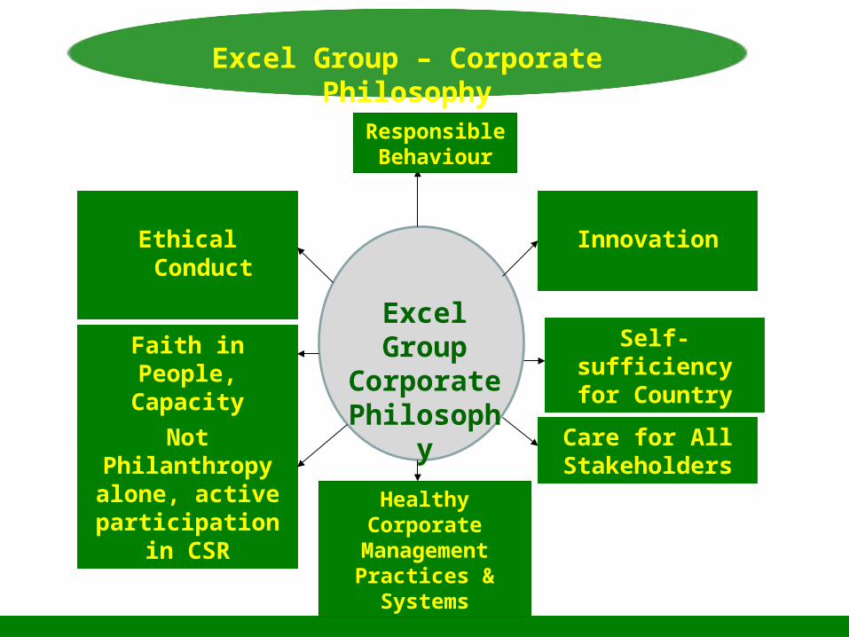
Excel Group – Corporate Philosophy
Self-sufficiency for Country
Innovation
Excel Group Corporate
Philosophy
Responsible Behaviour
Care for All Stakeholders
Healthy Corporate Management Practices &
Systems
Faith in People, Capacity Building
Ethical Conduct
Not Philanthropy alone, active
participation in CSR

Choice of Businesses & New InitiativesGuiding Principles
Guiding Principles
National & Global Outlook
Relevance to Social needs and
problems
Various Segments served eg. Agri & food, water, energy,
waste management
Basic needs of Humans &
Environment

Programmes & Services
Water Harvesting
and Irrigation
Agriculture development & Allied Activities
Animal Husbandry and Dairy
Environment, Plantation &
New Plant Varieties
Drought Proofing
Programme
Renewable Energy &Energy
Conservation
Rural Employment Training-cum-Production
Programme
Education and Vocational Training
Women empowerment
Extension Services
Disaster Mitigation & Rehabilitation
Activity
Socio-Economic Development in Tribal
Areas
Quality Healthcare ServicesExcel’s
NGOs

Input & Market linkages – Agrocel, KCSProcessing & value addition – Agrocel-TranschemFarm Tool & Equipment Bank – Transpek, SFT, VRTIFood Grain preservation and Storage – ECCLInformation Guidance – Kisan MitraWater Management – VRTI, AgrocelHealth & Nutrition Management – SFT, Sahajanand HospitalEducation & Training – VRTI (as a nodal agencyWeather related information – ICCSIR, VRTIArea Planning – VRTI, ACTDisasters Management – Abhiyan, VRTIPasture Development and Fodder Management - VRTI
Services

Take care of the earth and she will take care of you
“Men are born from you and function on you. You support the men and the animals
The trees and plants firmly stand on you. The sea, the rivers and other water reservoir are found on you. The forest animals roam on you.
The birds of various kinds fly over you. The hills and mountain
with rich forest stands on you. The rice and barley grow on you. The rich deposits of gold and other minerals are found on you. The autumn winter and rainy season enrich you. The breezes moves on you spreading the fragrant flower dust and gently moving the trees.
O prithivi, you are my mother and I am your son.”
- Prithvi Sukta of Atharva Veda

Mission For The Current Decade
To Contribute in reduction of CO2 levels in the atmosphere from 380
ppm to 280 ppmthrough
Photosynthesis for the betterment of all living beings
& survival of our mother earth.

Save the EarthBy
PromotingPhotosynthesis
Save the Earth, There is no Planet B

Changes in rain fall pattern causing flood, draught and increased risk in farmingPoor & small farmers are becoming more vulnerableSoil fertility is reducingGround water levels are reducing dangerously Sea levels are risingInflation due to rise in food pricesSerious health issuesDevelopment has become economy centered on GDP base, resulting in non-inclusive growthSocial & ecological values are not considered in development
Burning Issues of Current Decade

Biomass productions – crops, grasses and treesAppropriate land and water management by millions of farmers especially small and marginal farmers
Even Urban agriculture
Solutions Can Come From

An integrated approach to planning using the whole River Basin as a basis for holistic & sustainable planning, can provide a good solution to ensure Economic, Social and Environmental sustainability.
River Basin

If the River basin is seen from the perspective of an Agro-Industrial Complex with responsible use of natural assets & resources, for providing renewable resources as Raw Materials, to which value addition is done by appropriate processes & technologies, it can lead to the objectives narrated above
Agro Industrial Complex
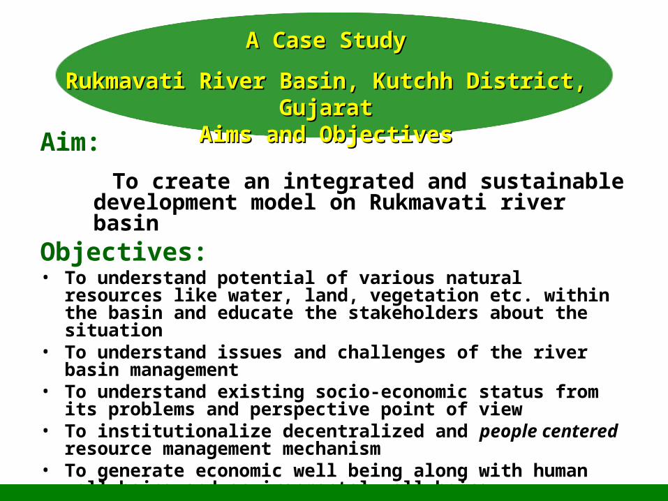
Aim: To create an integrated and sustainable
development model on Rukmavati river basinObjectives:• To understand potential of various natural resources like water,
land, vegetation etc. within the basin and educate the stakeholders about the situation
• To understand issues and challenges of the river basin management
• To understand existing socio-economic status from its problems and perspective point of view
• To institutionalize decentralized and people centered resource management mechanism
• To generate economic well being along with human well being and environmental well being
• To mange micro climate in the basin area
A Case StudyA Case Study
Rukmavati River Basin, Kutchh District, GujaratRukmavati River Basin, Kutchh District, GujaratAims and ObjectivesAims and Objectives

04/24/23 14
RUMAVATI RIVER BASINRUMAVATI RIVER BASIN
April 24, 20231515
Dahinsara
Kurbai
Don
Maska
Bheraiya
Asambiya Mota
Samatra
Punadi
Koday
Bhadai Moti
Mandvi
DrainageRiver BedWaterbody
Rukamavati Wshed
Stdudy Villages
4 0 4 8 Kilometers
N
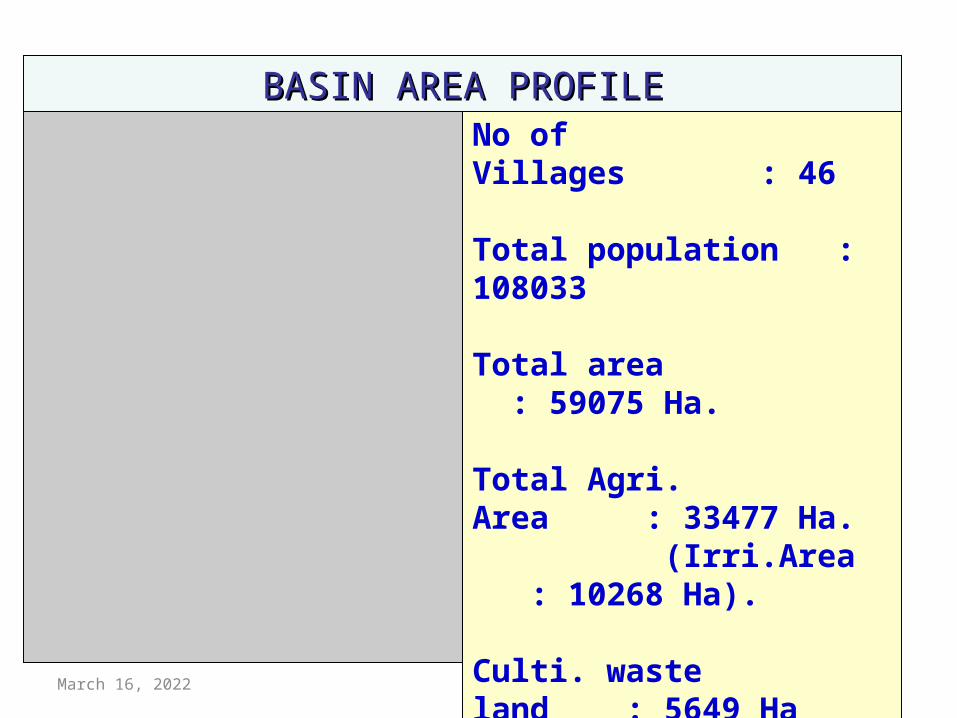
No of Villages : 46
Total population : 108033
Total area : 59075 Ha.
Total Agri. Area : 33477 Ha. (Irri.Area : 10268 Ha).
Culti. waste land : 5649 Ha
Forest area : 4282 Ha.
Other Land : 15671 Ha.
BASIN AREA PROFILEBASIN AREA PROFILE

April 24, 2023 1616
• In the upper part of the basin, sand stone aquifer was very good source of water and similarly in the lower side sandy aquifer, in the past decades (Map)
• Farmers were traditionally irrigating their fields though flood irrigation and wasted ground water blindly
• By the time, to meet the irrigation demand, ground water extraction is increased rapidly with development of technologies like drilling of tube wells, Submersible pups etc..
• During the same period rain fall in the area was very low (Ave.350mm/ year)
• Consequently, water level gone down dangerously and at present in the lower part, level is far bellow the mean sea level which cause salinity ingress in costal aquifer (Hydrograph)
• In spite of that still only 31 % of total agri. land is having irrigation facilities while 69% is remain as rain fed or non irrigated
• Due to salinity ingress agricultural and horticultural crops are badly affected viz. Salinization of soil etc, decreased productivity
Historical background and factors leading to the current situation

Mota
Nagalpar
Nani
Rayan Moti
Mamaymora
Ludva
Vadasar
Asambiya Nana
Goniyasar
Rampar
Bheraiya
Durgapar
Jamthada
VinganiyaNabhoi
Darashadi
Jakhaniya
Kojachora
Samatra
Sarli
DhokdaAsambiya Mota
Bhadai Moti
Ajapar
Kurbai
Dahinsara
Dhunai
Vandhay
Vekra
Punadi
Vandh
Don
Koday
Mandvi
Geology
Bhuj FormationDeccan Trap
Jhuran FormationJumara Formation
Kankavati SeriesMadh Series
Recent
Study VillagesWatershed
6 0 6 12 Kilometers
N


April 24, 2023 19
Approach and Methodology
There are three phases of the entire project
Planning phaseImplementation phaseManagement phase

April 24, 2023 20
Selection of local youth as para engineers Intensive Training of selected para engineers. Mapping of basin area. . (Base map-land use map, Water Resource
Map, Geomorphology, Geo hydrology , Water level & Water quality map etc..)
Detail Basin Survey - ( Agriculture - Surface water - Animal husbandry - Rain fed farming-Irrigated farming (Through wells, Ponds, Dams, Canals etc.)- Well inventory- Food and fodder)
Formation of different types of groups Linkages & integration with various resources & & creating services Data Analysis: Analysis of data for strategic planning. Village wise Action plan with villagers through PRA (Participatory
Rural appraisal) Water harvesting structures - 25 structures completed and 13 in
progr.
PLANNING PHASE

PRA PHOTOGRAPHSPRA PHOTOGRAPHS


Over flowing check dam- Over flowing check dam- NagalparNagalpar

Impacts of rain water harvesting
Water level rise:Water level (m) Minimum Maximum
Pre monsoon 06 170
Post monsoon 03 165
Water level rise in basin area due to ground water recharging : 1.0 to 8.0 meters
Average rise : 4.0 m

Improvement in water quality
TDS (ppm) Minimum MaximumPre monsoon 882 9080
Post monsoon 326 4180
pH Minimum MaximumPre monsoon 7.14 9.14
Post monsoon 7.06 8.81
Water samples collected from monitoring wells show the following result
TDS (ppm) value reduced due to ground recharge from 190 ppm to 6815 ppm
pH value reduced due to ground recharge from 0.11 to 1.21

April 24, 2023 26
IMPLEMENTATION PHASE
For proper implementation, basin is divided into five clusters based on hydro- geological characteristics and problems of the area
We will adapt suitable strategy to overcome the problems for each cluster
Activates as per strategy will be carried out through linkages with Govt. departments and other funding agencies
Groups formed during planning phase will be involved in each stage of implementation

CLUSTER -1
CLUSTER -2
CLUSTER -3
CLUSTER -4
CLUSTER -5
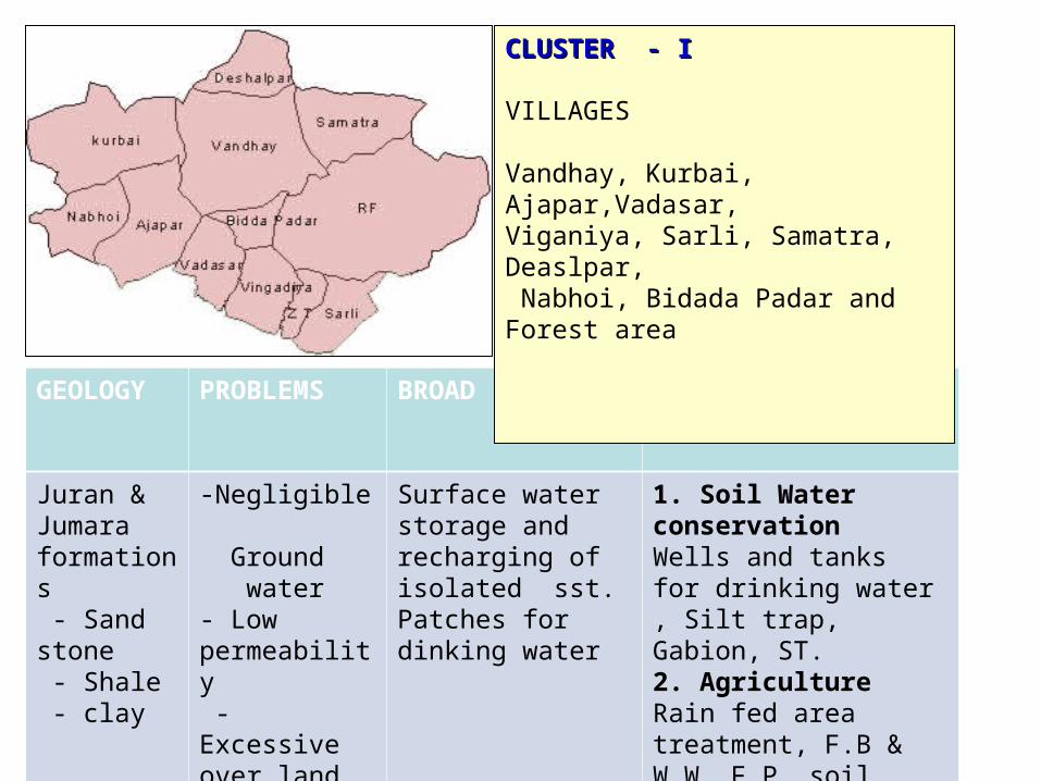
GEOLOGY PROBLEMS BROAD STRATEGY
ACTIVITIES
Juran & Jumara formations - Sand stone - Shale - clay
-Negligible Ground water- Low permeability - Excessive over land flow, head ward erosion
Surface water storage and recharging of isolated sst. Patches for dinking water
1. Soil Water conservationWells and tanks for drinking water , Silt trap, Gabion, ST.2. AgricultureRain fed area treatment, F.B & W.W, F.P, soil moisture conservation, grass land Dev. in forest area through JFM
CLUSTER - ICLUSTER - I
VILLAGES
Vandhay, Kurbai, Ajapar,Vadasar, Viganiya, Sarli, Samatra, Deaslpar, Nabhoi, Bidada Padar and Forest area

GEOLOGY PROBLEMS BROAD STRATEGY
ACTIVITIES
Bhuj formations - Sand stone
- Deep Ground water- Over exploitation of water- High Fe Impurity in water
Ground water recharge ,Judicious use of ground water, Participatory aquifer management( Shared aquifer, Demo of participatory ground water management)
1. Soil Water conservation Recharge structures like CD, PT, etc.2. Agriculture Promotion to micro irrigation and other water saving techniques.Promotion to Horticultural crops
CLUSTER - IICLUSTER - II
VILLAGES
Bheraiya, Ludva, Jamathda, Vekra, Rampara, Dahinsra and Dhunai
GEOLOGY PROBLEMS BROAD STRATEGY
ACTIVITIES
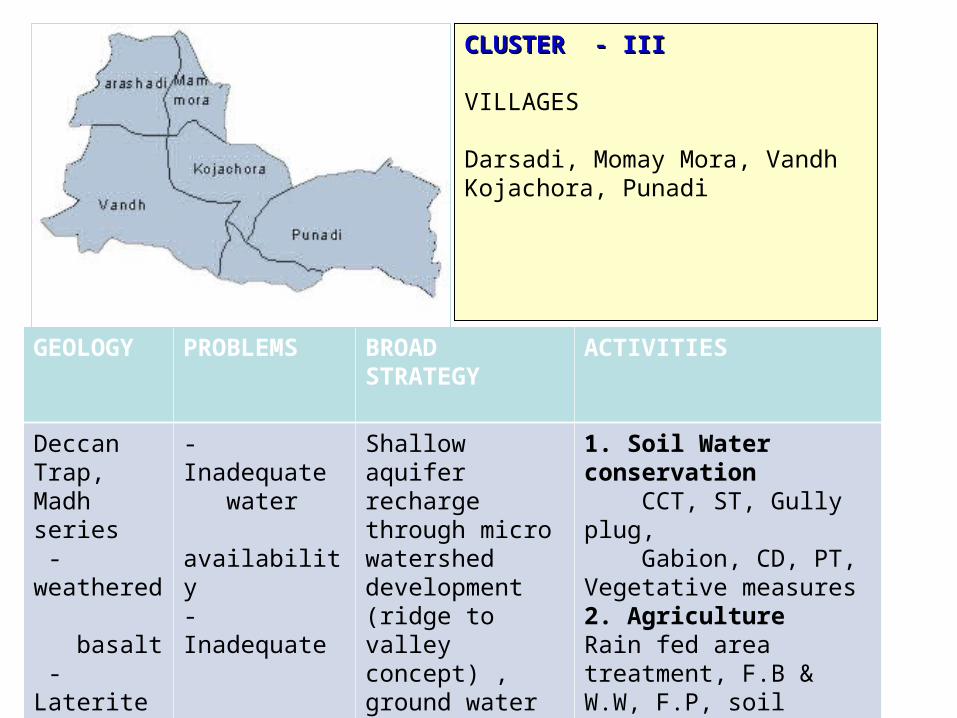
Deccan Trap, Madh series - weathered basalt - Laterite - Bentonite - Bauxite - clay
- Inadequate water availability- Inadequate irrigation facilities-Land degradation due to mining
Shallow aquifer recharge through micro watershed development (ridge to valley concept) , ground water management, land reclamation
1. Soil Water conservation CCT, ST, Gully plug, Gabion, CD, PT, Vegetative measures2. AgricultureRain fed area treatment, F.B & W.W, F.P, soil moisture conservation, grass land Dev. in forest area
CLUSTER - IIICLUSTER - III
VILLAGES
Darsadi, Momay Mora, VandhKojachora, Punadi

GEOLOGY PROBLEMS BROAD STRATEGY
ACTIVITIES
Kankavati& Madh series - Sand stone - Laterite - clay
- Deep Ground water- Over exploitation- Quality degradation-Prone to seawater ingression
Surface recharge, Injection recharge, sub surface recharge and water management, Roof top rain water harvesting.
1. Soil Water conservationCD, Injection well, subsurface structures, well recharge, Percolation tanks etc.2. Agriculture Micro irrigation, Water management through PIM , Promo. to HorticultureAgri .practices
CLUSTER - IVCLUSTER - IV
VILLAGES
Bhadai Moti, Dhokada, Don,Goniyasar nana, Goniyasar Mota,Asambiya Mota, Asambiya Nana,Koday/Madanpura, Jakhaniya, Talvana

GEOLOGY PROBLEMS BROAD STRATEGY
ACTIVITIES
Recent - Alluvium - Sand
-Salinity ingress-Over explo. Of Ground water
Salinity prevention activities, RRWH for drinking water, experiment of shallow zone recharge
1. Soil Water conservationCD, PT, Existing well/Bore well rechargeRRWHS etc2. AgricultureSoil reclamation , revival of Salt affected , Promo. to micro irrigation and Horticulture
CLUSTER - VCLUSTER - V
VILLAGES
Durgapar, Vada, Bharapar, MandviRayan nani, Rayan Moti, Nagalpar,Maska

Common activitiesCommon activities• Awareness generation• Capacity building of stakeholders through
training, workshop, seminar and exposure visits
• SHG group formation and micro enterprises• Prosumer societies• Joint forest management activities wherever
forest area is existed• CBO formation• Agro- industrial complex
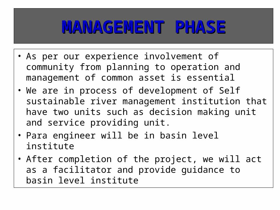
MANAGEMENT PHASEMANAGEMENT PHASE• As per our experience involvement of community from
planning to operation and management of common asset is essential
• We are in process of development of Self sustainable river management institution that have two units such as decision making unit and service providing unit.
• Para engineer will be in basin level institute• After completion of the project, we will act as a
facilitator and provide guidance to basin level institute

Positive impact on climate change
Natural resource management• Soil moisture conservation• Soil reclamation• Water harvesting and it’s management
Restored fresh water eco-systemIncreased soil fertilityIncreased crop productivity
Agri./Horticulture development and greenery in the basin
More photosynthesis
CO2
Fixation
Capacity of framers though trainings for..• Balance cropping and biomass planning• Mixed farming with animal husbandry, Dairy, Fishery poultry etc.
Solid and liquid waste management• Composting, recycling etc.
Reduction in METHANEgeneration

April 24, 2023 36
The main expectation from this project is to demonstrate successful
model of river basin management that can be replicated
Each cluster of the basin will be self reliant on their drinking water, food ,fodder and fuel requirement
Improvement of water quality as per drinking and irrigation norms
Green cover on the land will be restored
Finally contribute to improve GDP of the basin area, improve happiness index & Human Development Index of this basin area.
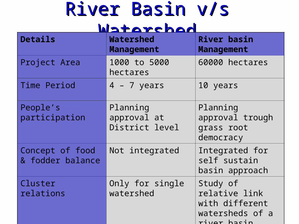
River Basin v/s WatershedRiver Basin v/s WatershedDetails Watershed
Management River basin Management
Project Area 1000 to 5000 hectares 60000 hectares
Time Period 4 – 7 years 10 years
People’s participation Planning approval at District level
Planning approval trough grass root democracy
Concept of food & fodder balance
Not integrated Integrated for self sustain basin approach
Cluster relations Only for single watershed
Study of relative link with different watersheds of a river basin

April 24, 2023 38
THANKSTHANKS