sustainable adaptive gradients in the coastal environment 2015 welcome to jamaica dale webber
TRANSCRIPT

Sustainable Adaptive Gradients in the Coastal Environment2015
Welcome to JamaicaDale Webber

2Participating Islands
Professor Dale Webber UWI

• Third-largest island of the Greater Antilles. • 10,990 square kilometres (4,240 sq mi) in area, lies about
145 kilometres south of Cuba, and 191 kilometres (119 mi) west of Haiti.
• Jamaica is the fifth-largest island

More than a Beach

Old and new building

Famous Sons & Daughters

JAMAICA…the IslandJAMAICA…the Island

ST. ANN
C LARENDO N
WESTM O RELAND
HANO VER
TRELAWNY
ST. ELIZABETH M ANC HESTER
ST. J AM ES
ST. THO M AS
ST. M ARY
ST. C ATHERINE
ST. ANDREW
KING STO N
PO RTLAND
Marine territory is now approximately 161,000 Km2
i.e. 24 times the land area of mainland Jamaica = Archipelagic state
JAMAICA…an Island?JAMAICA…an Island?

Diverse Jamaican community types
1. Wet Limestone Forest2. Dry Limestone Forest3. Thorn Scrub4. Cactus Thorn Scrub5. Strand Woodland6. Lower Montane Rain Forest7. Montane Mist Forest8. Elfin Woodland9. Montane Sclerophyll10. Herbaceous Swamp11. Mangrove Woodland12. Marsh Forest

Jamaica’s Biodiversity at a glance.Over 8,000 species recorded
Ranked 5th among worlds islands in endemic species
Group No. of Species Endemics
Plants (Flowering /ferns/lichens)
>6000 28%
Butterflies >120 15?
Frogs 19 17
Breeding birdsMigrant birds
113100
28
Mammals 22 (21 bats) 4?

Port Royal and environs

Port Royal and environs over 1000 species recorded
Taxon Number of Species
Macroalgae 98+Porifera 54+Cnidaria 156+Ctenophora 4Platyhelminthes 3+Annelida 26+Crustacea 158+Mollusca 295Bryozoa 18+Chaetognatha 3Echinodermata 81Hemichordata 2Chordata 228-278+
Goodbody, 2004


Integrated threat from local activities: today
Low Medium High Very High

Integrated local and global threat: 2030
Low Medium High CriticalVery High

Integrated local and global threat: 2050
Low Medium High CriticalVery High

Social and economic vulnerability to reef degradation

Socioeconomic impacts:
• Increased loss of property and coastal habitats• Increased flood risk and potential loss of life• Damage to coastal protection works and other
infrastructure• Increased disease risk• Loss of renewable and subsistence resources• Loss of tourism, recreation, and transportation
functions• Impacts on agriculture and aquaculture through
decline in soil and water quality.

Change in water level at shore due to reef degradation
Negril Discovery Bay Kingston / PR0
0.20.40.60.8
11.21.41.6
Water Level for 1-year storm event (m)
current reef degraded reef
Negril Discovery Bay Kingston / PR0
0.5
1
1.5
2
2.5
3
3.5
Water level for 25-yr storm event (m)
current reef degraded reef

25-year storm scenario
Property Affected:Current reef – 39 buildings Degraded Reef – 154 buildings, including 2 hotels, church, airfield

Environmental Treaties & Convention

Jamaica
• Jamaica is a key partner to over 40 International and Regional Multilateral Environmental Agreements.
• 19 are directly related to Climate Change.

• NRCA Act 1991• Beach Control Act 1956• Morant & Pedro Cays Act 1904• Wild Life Protection Act 1945• Mining Act 1947• Tourist Board Act 1955• Town and Country Planning Act 1958• Urban Development Corporation Act 1968• Port Authority Act 1972• Fishing Industry Act 1975 • Harbours Act 1976• Quarries Control Act 1983• Litter Act 1986• Watersheds Protection Act 1963
Jamaican Legislation 23 important Acts/Laws

Jamaican Legislation• Jamaica Maritime Institute Act 1992• Water Resources Act 1995• Pesticide Amendment Act 1996• EEZ Act 1991• Maritime Areas Act 1996• Forest Act 1996• Shipping Act 1998• ODPEM Act 1998• Endangered Species Act 2000

Professor Dale Webber UWI 25
Klotzbach and grAy 2012


27Professor Dale Webber UWI

Professor Dale Webber UWI 28
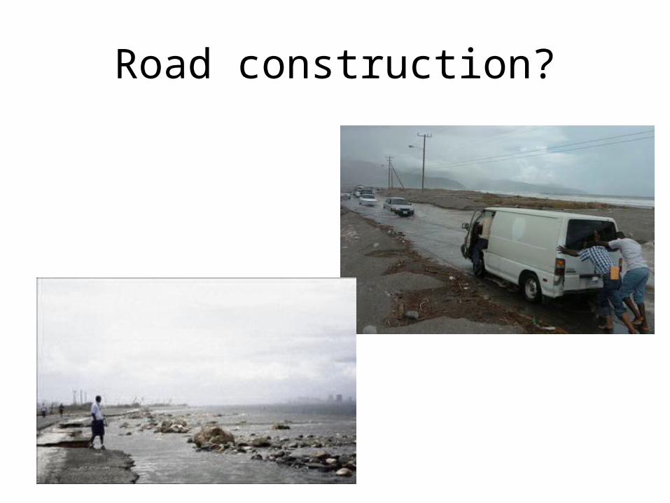
Road construction?

Professor Dale Webber UWI 30

Kingston HarbourPhysical structure


Portmore develpment

10 year storm surge

25 year storm surge

50 year storm surge

100 year storm surge

SAGE 2015 field visits
• Kingston Harbour
• Portmore City development