sussex county council · sussex county council meetings can be monitored on the internet at . ......
TRANSCRIPT
Sussex County CouncilPublic/Media Packet
MEETING:September 29, 2015
**DISCLAIMER**This product is provided by Sussex County government as a courtesy to the generalpublic. Items contained within are for background purposes only, and are presented‘as is’. Materials included are subject to additions, deletion or other changes prior tothe County Council meeting for which the package is prepared.
Sussex County Council2 The Circle | PO Box 589
Georgetown, DE 19947(302) 855-7743
NOTE - COUNCIL WILL HOLD A SIGN ORDINANCE WORKSHOP ON
SEPTEMBER 29, 2015, AT 9:00 A.M. AT THE WEST COMPLEX.
A G E N D A
SEPTEMBER 29, 2015
1:00 P.M.
**AMENDED ON September 23, 2015 at 12:15 p.m.1
Call to Order
Approval of Agenda
Approval of Minutes
Reading of Correspondence
Public Comments
Todd Lawson, County Administrator
1. Wastewater Agreement No. 831-1Sussex County Project No. 81-04The Vineyards at Nassau Valley – Phase 1AWest Rehoboth Expansion of the Dewey Beach Sanitary Sewer District
2. Administrator’s Report
John Ashman, Director of Utility Planning
1. Berzin Expansion of the South Bethany Sanitary Sewer District
A. Request to Prepare and Post Notices
Sussex County Council Agenda September 29, 2015 Page 2 of 3.
Julie Cooper, Project Engineer
1. SCRWF Septage Acceptance Plant, Project 14-20
A. Substantial Completion
Joe Wright, Acting County Engineer
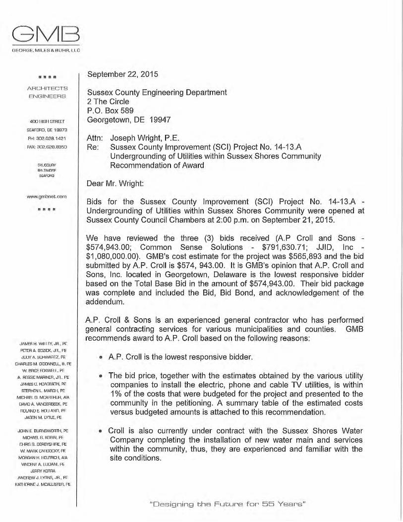
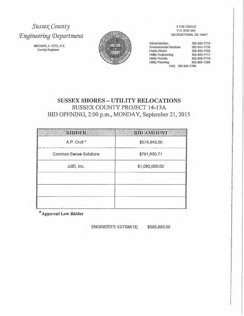
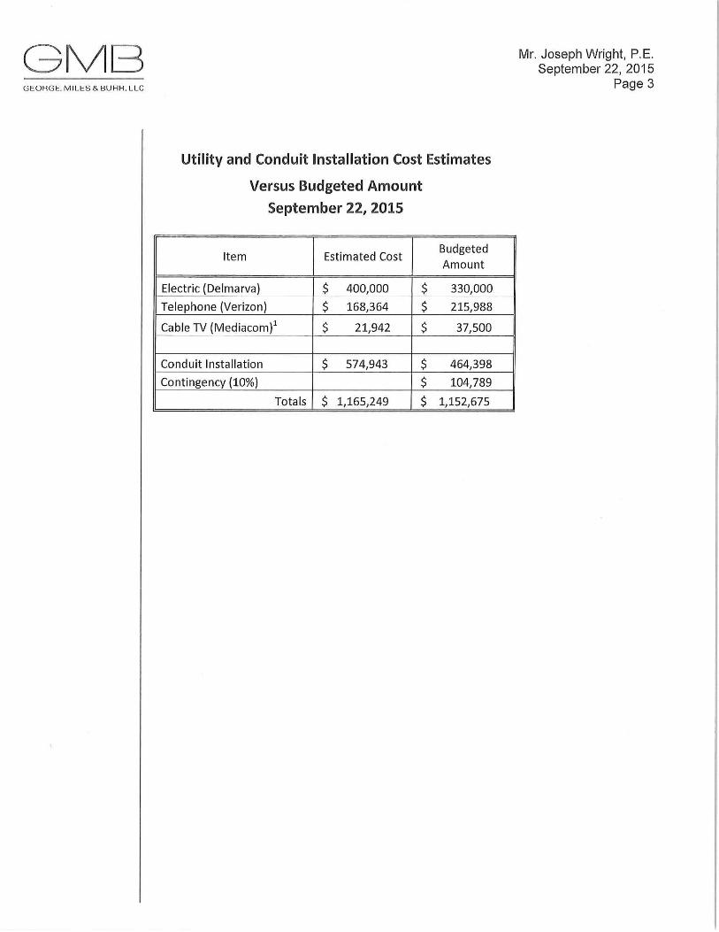
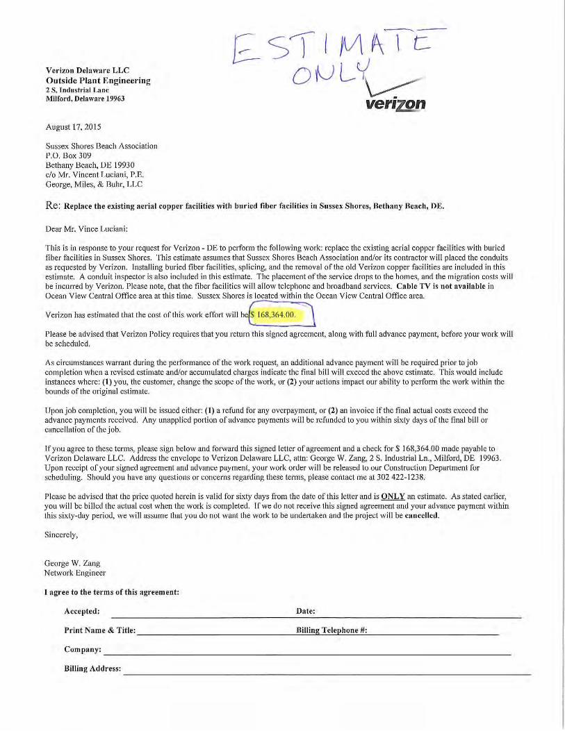
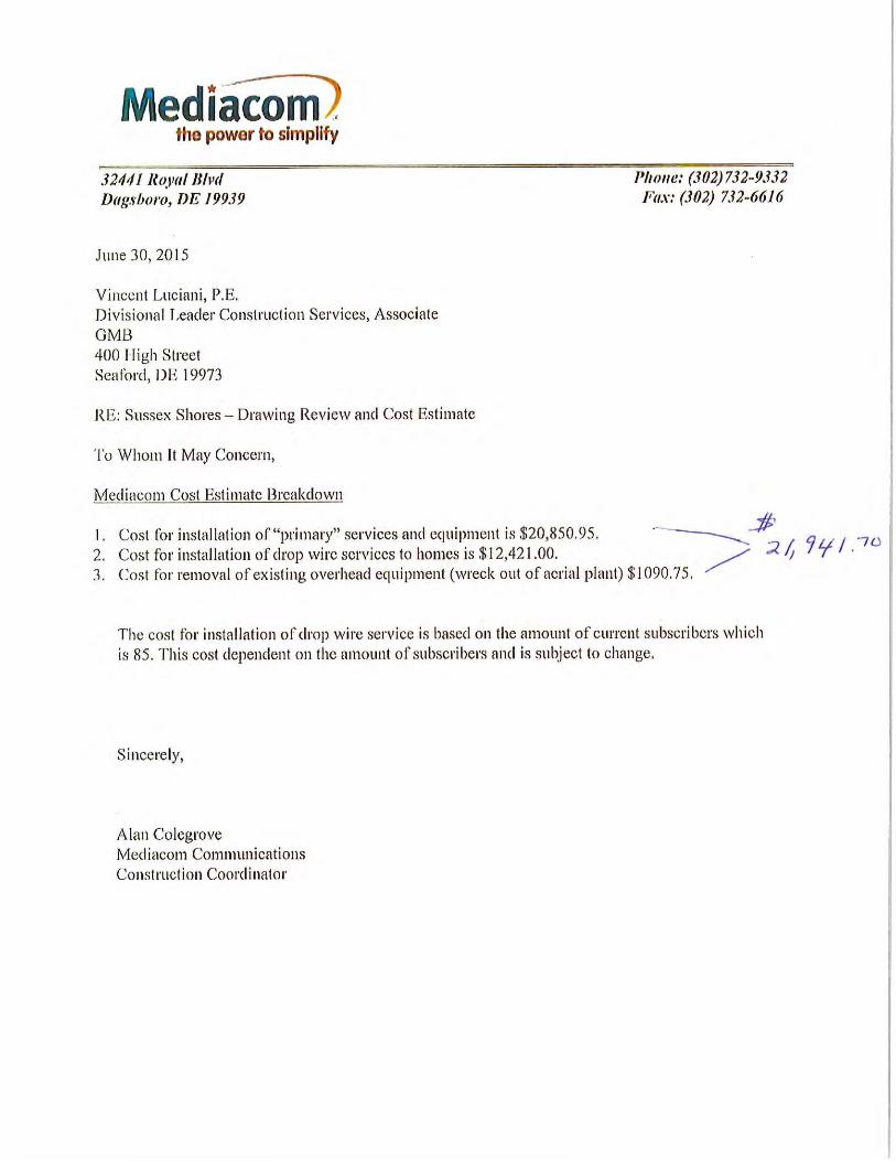
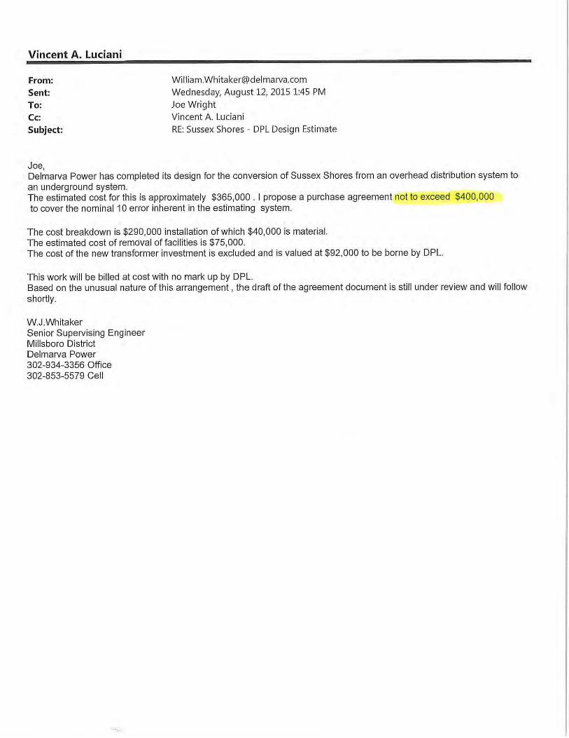
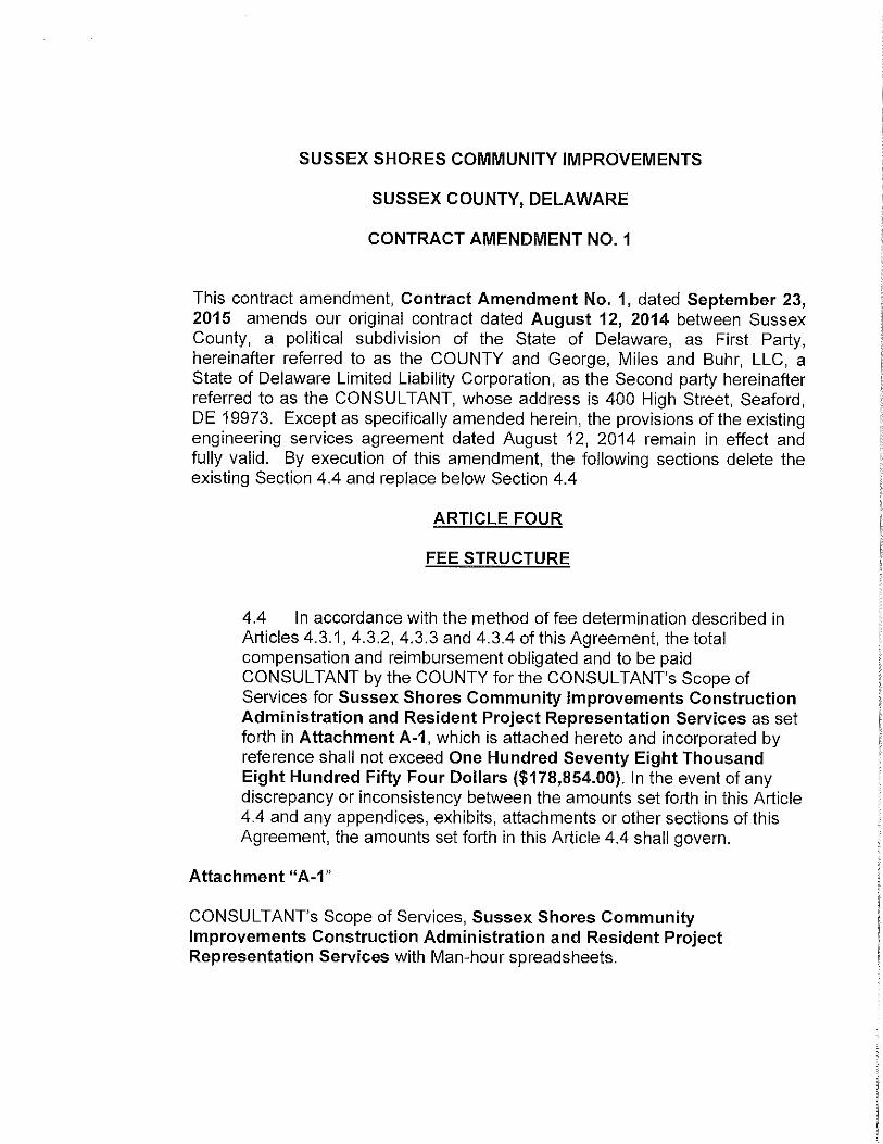
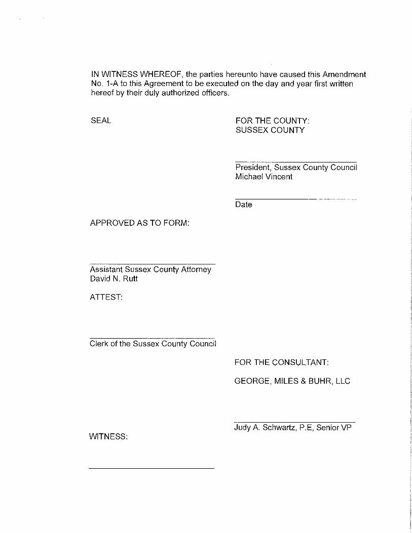
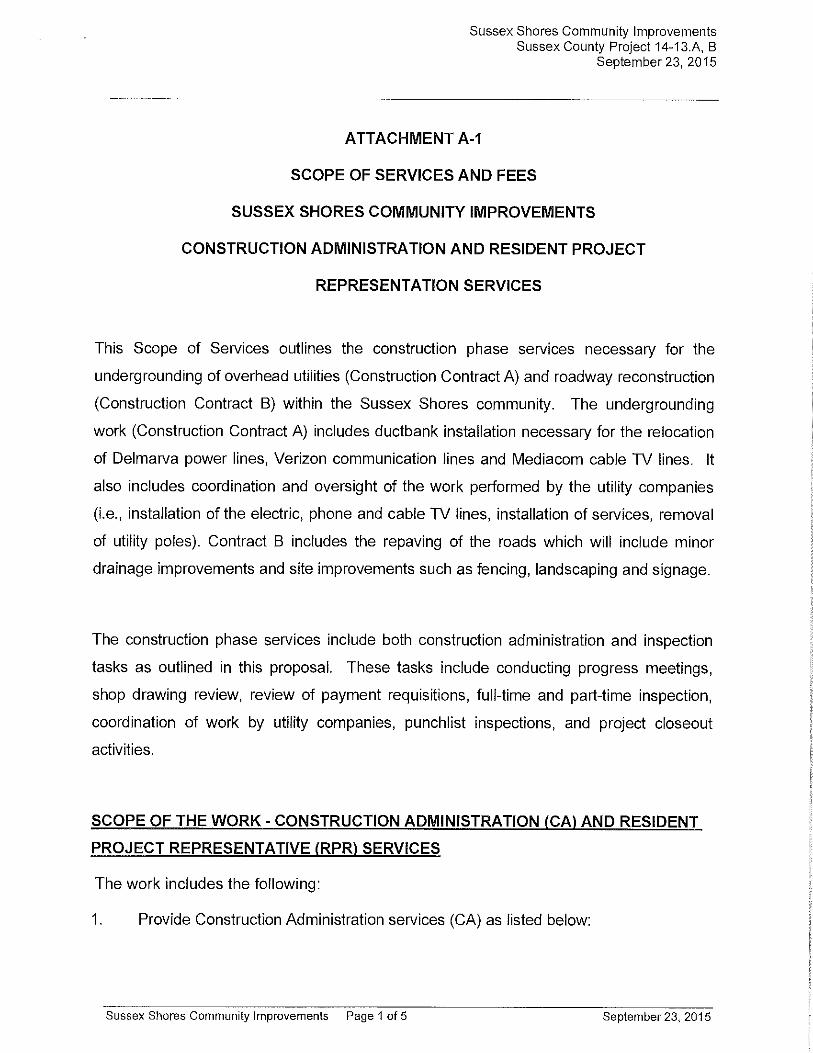
1. Sussex Shores Subdivision – Chapter 96, Project 14-13A
A. Bid Award
2. Sussex Shores Subdivision – Chapter 96, Projects 14-13 A, B
A. Construction Administration and Resident Project Representative Services
** 3. Contract 15-08A, PS 210 Force Main to Inland Bays Regional Wastewater Facility
A. Bid Rejection
Janelle Cornwell, Planning and Zoning Manager
1. Award of Planning Services
Lawrence Lank, Director of Planning and Zoning
1. Arbors of Cottagedale
A. Suspension of Substantial Construction Deadline for 6 Months
Grant Request
1. Greater Georgetown Chamber of Commerce for Wings & Wheels.
Introduction of Proposed Zoning Ordinances
Council Members′ Comments
1:30 p.m. Public Hearings
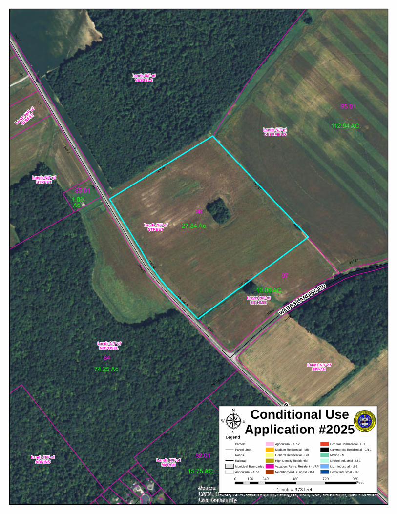
Conditional Use No. 2025 filed on behalf of Rudy South c/o T & C Properties, LLC “AN ORDINANCE TO GRANT A CONDITIONAL USE OF LAND IN AN AR-1 AGRICULTURAL RESIDENTIAL DISTRICT FOR BOAT SALES, SERVICE AND STORAGE TO BE LOCATED ON A CERTAIN PARCEL OF LAND LYING AND BEING IN INDIAN RIVER HUNDRED, SUSSEX COUNTY, CONTAINING 27.84 ACRES, MORE OR LESS” (located northeast of Robinsonville Road (Road 277), approximately 1,200 feet northwest of Webb’s Landing Road (Road 277B) (911 Address: None Available) (Tax Map I.D. No. 234-6.00-96.00)
Sussex County Council Agenda September 29, 2015 Page 3 of 3.
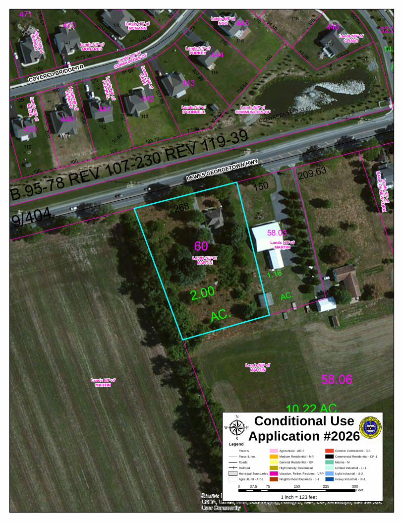
Conditional Use No. 2026 filed on behalf of Cristian Omar Hernandez Perez and Terri L. Martin “AN ORDINANCE TO GRANT A CONDITIONAL USE OF LAND IN AN AR-1 AGRICULTURAL RESIDENTIAL DISTRICT FOR A HOME BASED BUSINESS (AUTO REPAIR, DETAILING, AND AUTO RESALES) TO BE LOCATED ON A CERTAIN PARCEL OF LAND LYING AND BEING IN BROADKILL HUNDRED, SUSSEX COUNTY, CONTAINING 1.982 ACRES, MORE OR LESS” (located south of Lewes-Georgetown Highway (Route 9), 0.8 mile east of Harbeson Road (Route 5) at Harbeson) (911 Address: 26740 Lewes-Georgetown Highway, Harbeson) (Tax Map I.D. No. 235-30.00-60.00)
Conditional Use No. 2027 filed on behalf of SLC Homestead, LLC “AN ORDINANCE TO GRANT A CONDITIONAL USE OF LAND IN AN AR-1 AGRICULTURAL RESIDENTIAL DISTRICT FOR A HOME BUSINESS - RETAIL GUN SHOP AND GUNSMITHING TO BE LOCATED ON A CERTAIN PARCEL OF LAND LYING AND BEING IN DAGSBORO HUNDRED, SUSSEX COUNTY, CONTAINING 6.61 ACRES, MORE OR LESS OF A 14.04 ACRE TRACT” (located east of Iron Branch Road (Road 331), 2,500 feet northeast of Main Street in Dagsboro) (911 Address: 31005 Iron Branch Road, Dagsboro) (Tax Map I.D. No. 233-11.00-17.00 (Part of)
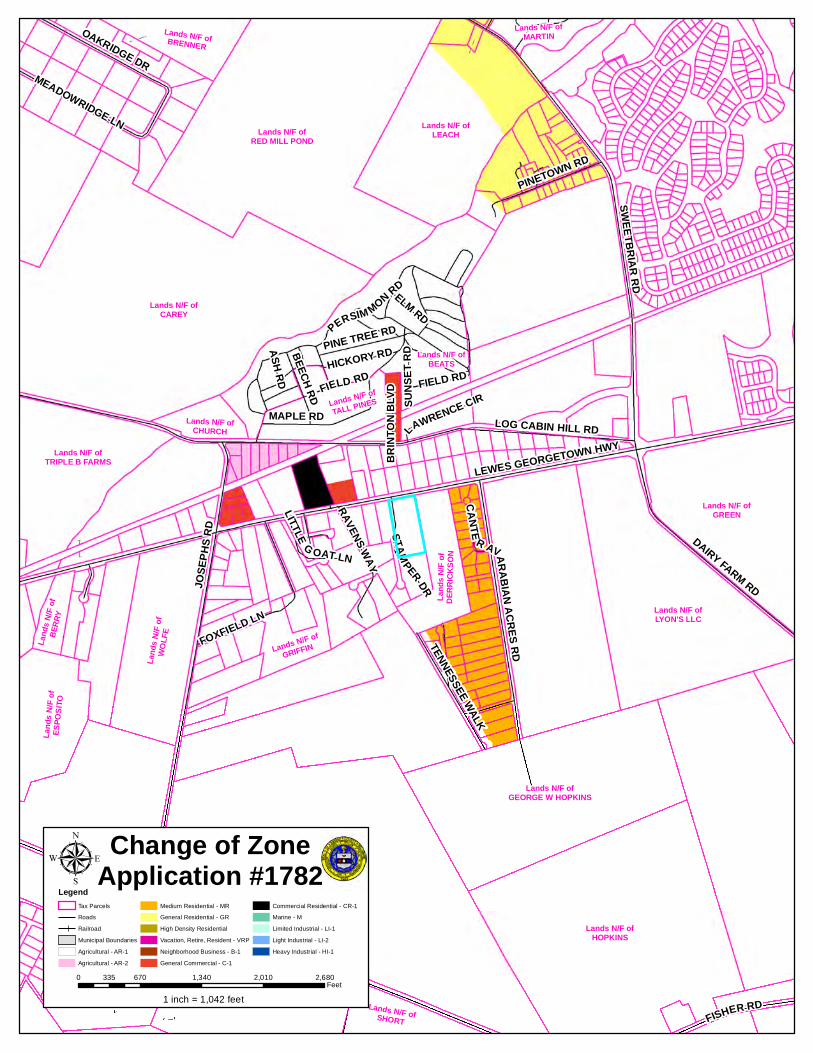
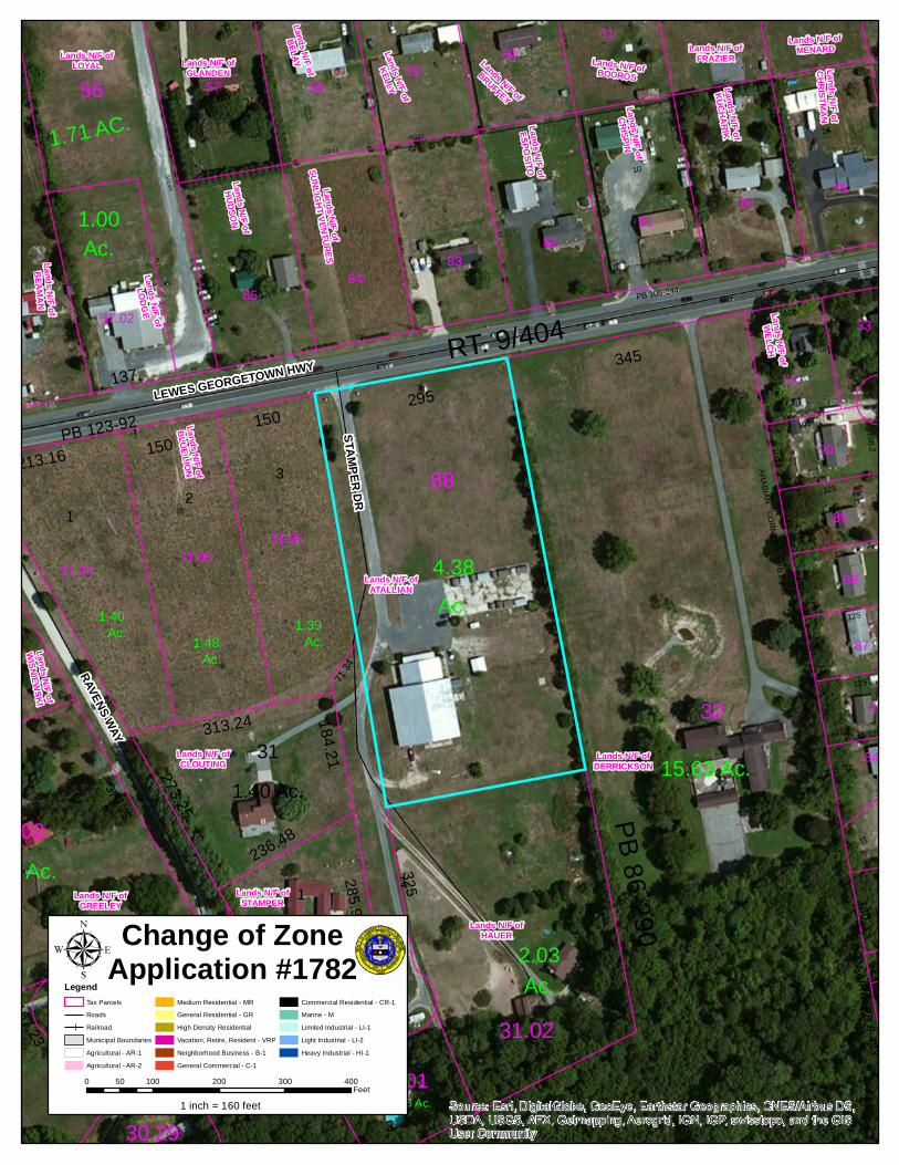
Change of Zone No. 1782 filed on behalf of Robert Atallian “AN ORDINANCE TO AMEND THE COMPREHENSIVE ZONING MAP OF SUSSEX COUNTY FROM AN AR-1 AGRICULTURAL RESIDENTIAL DISTRICT TO A CR-1 COMMERCIAL RESIDENTIAL DISTRICT FOR A CERTAIN PARCEL OF LAND LYING AND BEING IN LEWES AND REHOBOTH HUNDRED, SUSSEX COUNTY, CONTAINING 4.38 ACRES, MORE OR LESS” (located south of Lewes-Georgetown Highway (Route 9), 615 feet west of Arabian Acres Road (Road 282) (911 Address: 18501 Stamper Drive, Lewes) (Tax Map I.D. No. 334-4.00-88.00)
Adjourn
********************************
Sussex County Council meetings can be monitored on the internet at www.sussexcountyde.gov.
*********************************
In accordance with 29 Del. C. §10004(e)(2), this Agenda was posted on September 22, 2015, at 4:55 p.m., and at least seven (7) days in advance of the meeting.
This Agenda was prepared by the County Administrator and is subject to change to include the addition or deletion of items, including Executive Sessions, which arise at the time of the Meeting.
Agenda items listed may be considered out of sequence.
# # # # ___________________________________________________
1 Per 29 Del. C. § 10004 (e) (5) and Attorney General Opinion No. 13-IB02, this agenda was amended to include Contract 15-08A, PS 210 Force Main to Inland Bays Regional Wastewater Facility – Bid Rejection. The agenda amendment was required to address this matter which needs immediate Council attention and which arose after the initial posting of the agenda but before the start of the Council meeting.


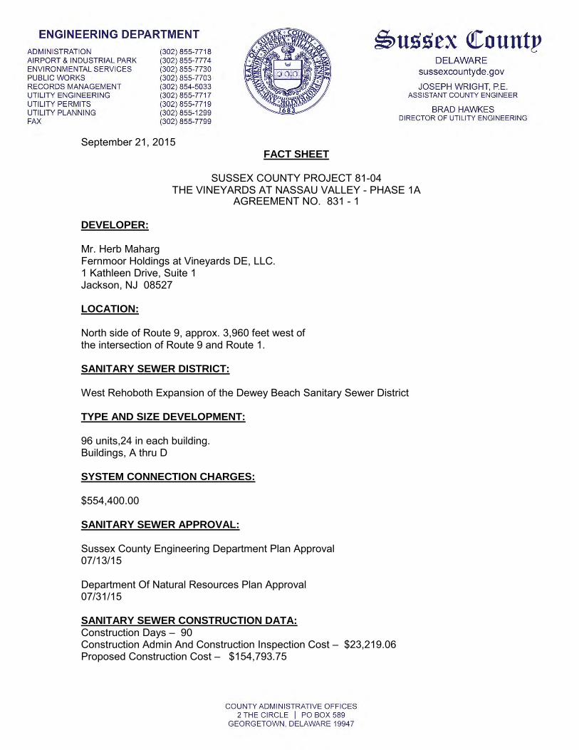
September 21, 2015 FACT SHEET
SUSSEX COUNTY PROJECT 81-04 THE VINEYARDS AT NASSAU VALLEY - PHASE 1A
AGREEMENT NO. 831 - 1
DEVELOPER:
Mr. Herb Maharg Fernmoor Holdings at Vineyards DE, LLC. 1 Kathleen Drive, Suite 1 Jackson, NJ 08527
LOCATION:
North side of Route 9, approx. 3,960 feet west of the intersection of Route 9 and Route 1.
SANITARY SEWER DISTRICT:
West Rehoboth Expansion of the Dewey Beach Sanitary Sewer District
TYPE AND SIZE DEVELOPMENT:
96 units,24 in each building. Buildings, A thru D
SYSTEM CONNECTION CHARGES:
$554,400.00
SANITARY SEWER APPROVAL:
Sussex County Engineering Department Plan Approval 07/13/15
Department Of Natural Resources Plan Approval 07/31/15
SANITARY SEWER CONSTRUCTION DATA: Construction Days – 90 Construction Admin And Construction Inspection Cost – $23,219.06 Proposed Construction Cost – $154,793.75

September 29 2015
PROPOSED MOTION
BE IT MOVED THAT BASED UPON THE RECOMMENDATION OF THE SUSSEX
COUNTY ENGINEERING DEPARTMENT, FOR SUSSEX COUNTY PROJECT NO. 81-
04, AGREEMENT NO. 831-1 THAT THE SUSSEX COUNTY COUNCIL EXECUTE A
CONSTRUCTION ADMINISTRATION AND CONSTRUCTION INSPECTION
AGREEMENT BETWEEN SUSSEX COUNTY COUNCIL AND "FERNMOOR
HOLDINGS AT VINEYARDS DE, LLC.”, FOR WASTEWATER FACILITIES TO BE
CONSTRUCTED IN "THE VINEYARDS AT NASSAU VALLEY – PHASE 1A” IN THE
WEST REHOBOTH EXPANSION OF THE DEWEY BEACH SANITARY SEWER
DISTRICT.
ORDINANCE NO. 38 AGREEMENT NO.831-1
TODD LAWSON COUNTY ADMINISTRATOR

Berzin Expansion of SBSSD Fact Sheet
Expansion of the South Bethany Sanitary Sewer District to include balance of proposed Berzin
project and infill area
Letter and check received from developer for annexation.
Project is contiguous with part of the proposed subdivision already in the sewer district.
Project currently consists of 102 EDUs with a Commercial portion to be submitted for approval in
the future.
The project will install connection points for (3) other parcels currently in the sewer district but not
yet served.
The Developer and property owners will be responsible for System Connection fees in the amount
of $5,775.00 per EDU.
The tentative date for the Public Hearing is November 3, 2015 should the motion pass.
File: OM 3.15
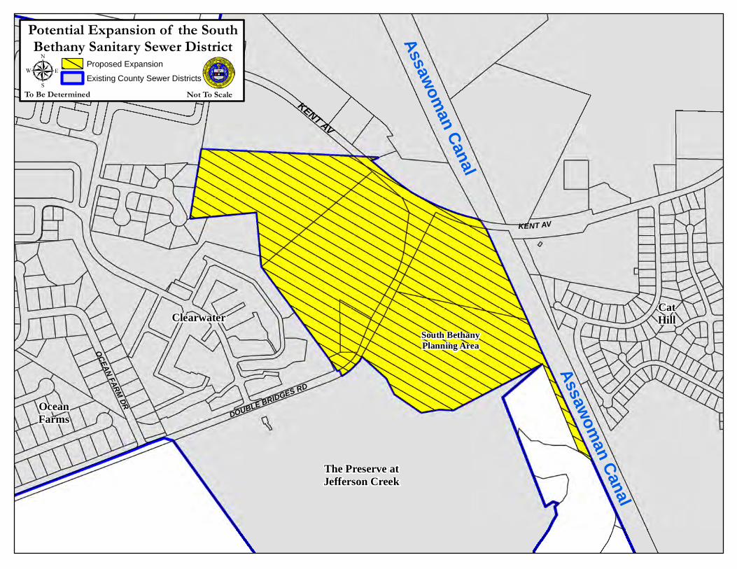
KENT AV
MUDDY NECK RD
KENT AV
DOUBLE BRIDGES RD
OCEAN FARM DR
N HAMPTON CIRSOUTH BETHANY SSDµ Proposed Expansion
Existing County Sewer Districts
Potential Expansion of the SouthBethany Sanitary Sewer District
Not To ScaleTo Be Determined
ClearwaterSouth BethanyPlanning Area
Assawoman Canal
Assawoman Canal
CatHill
OceanFarms
The Preserve atJefferson Creek

PROPOSED MOTION
BE IT MOVED BY THE SUSSEX COUNTY COUNCIL THAT
THE SUSSEX COUNTY ENGINEERING DEPARTMENT IS
AUTHORIZED TO PREPARE AND POST NOTICES FOR THE
EXTENSION OF THE SOUTH BETHANY SANITARY SEWER
DISTRICT BOUNDARY TO INCLUDE THE BALANCE OF THE
PROPOSED SUBDIVISION OF BERZIN AND THE
SURROUNDING AREA AS PRESENTED ON OCTOBER 6, 2015.
JOHN J. ASHMAN FILE: OM-3.15
OCTOBER 6, 2015


JANELLE M. CORNWELL, AICP Sussex County PLANNING & ZONING MANAGER DELAWARE
(302) 855-7878 T sussexcountyde.gov (302) 854-5079 F
COUNTY ADMINSITRATIVE OFFICES 2 THE CIRCLE I PO BOX 417
GEORGETOWN, DELAWARE 19947
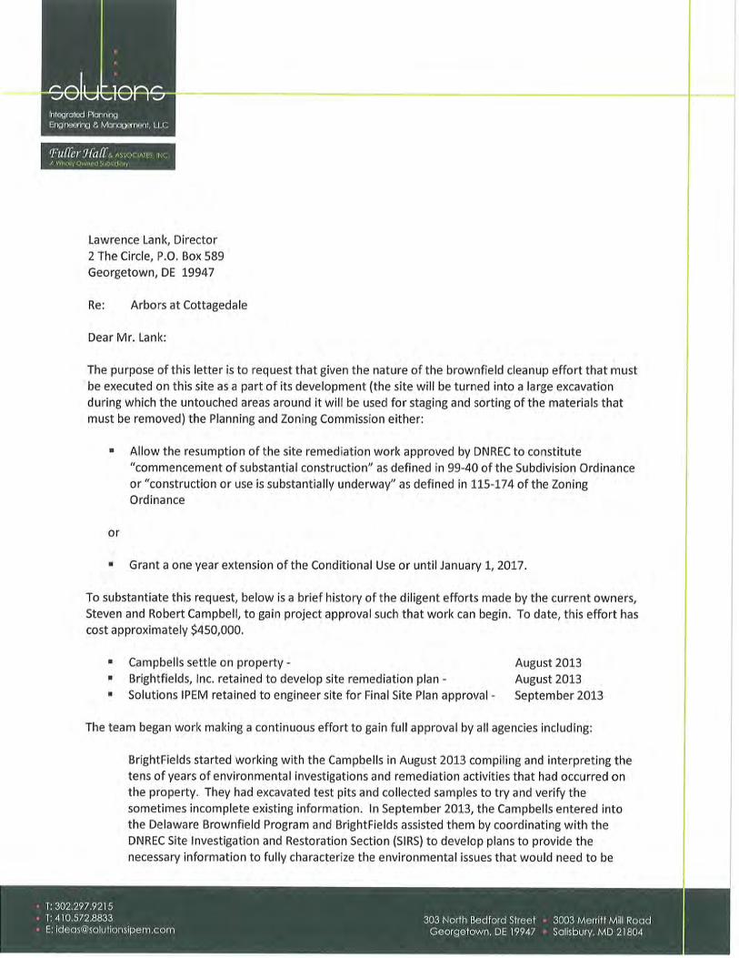
To: Sussex County Council Members From: Janelle Cornwell, AICP, Planning & Zoning Manager CC: Todd Lawson, County Administrator, Lawrence Lank, Planning Director Date: September 25, 2015 RE: The Arbors at Cottagedale Time Extension
At their meeting of August 27, 2015 the Planning and Zoning Commission considered a request for a one (1) year time extension regarding the Arbors at Cottagedale (CU 1845) project for the construction of 168 affordable housing dwelling units to be located off of Mackenzie Way off Plantations Rd. The Planning Commission approved a suspension of the time extension for six (6) months beginning on August 27, 2015. The suspension means that the site shall be substantially under construction by July 1, 2016. The decision was based on letters received on August 5, 2015 and August 7, 2015 from the applicant explaining the history of the site including the Brownfield remediation required prior to construction of the proposed housing and the fact that they site is utilizing the County’s Moderately Priced Rental Unit Program.
The applicant’s attorney is requesting that the County Council affirm or grant approval of the decision made by the Planning Commission.


PUBLIC HEARINGS September 29, 2015
This is to certify that on August 27, 2015 the Sussex County Planning and Zoning Commission conducted a public hearing on the below listed applications for Conditional Use and Change of Zone. At the conclusion of the public hearings, the commission moved and passes that the applications be forward to the Sussex County Council with the recommendations as stated.
Respectfully submitted:
County Planning & Zoning Commission of Sussex County
Lawrence Lank Planning and Zoning Director
The attached comments relating to the public hearings are findings of the Planning and Zoning Commission based upon a summary of comments read into the record, and comments state by interested parties during the public hearings.
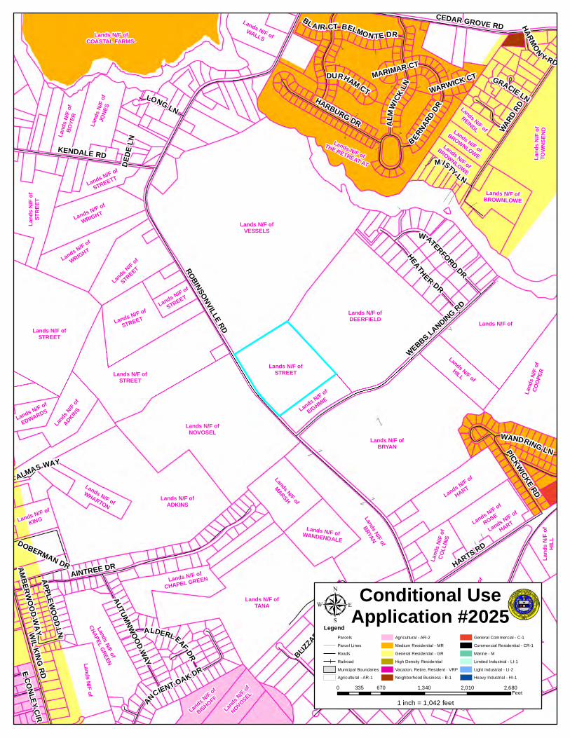
C/U #2025 – Rudy South c/o T & C Properties, LLC An Ordinance to grant a Conditional Use of land in an AR-1 (Agricultural Residential District) for boat sales, service and storage to be located on a certain parcel of land lying and being in Indian River Hundred, Sussex County, containing 27.84 acres, more or less. The property is located northeast of Robinsonville Road (Road 277) approximately 1,200 feet northwest of Webb’s Landing Road (Road 277B) (911 Address: None Available) Tax Map I.D. 234-6.00-96.00.
The Commission found that the Applicant provided a survey/site plan with the application when it was filed on June 8, 2015, and that an Exhibit Booklet was submitted on August 17, 2015.
The Commission found that DelDOT provided comments on April 17, 2015 and May 6, 2015 in the form of letters and a Support Facilities Report referencing that originally the Department had referenced that an Area-Wide Study Fee could be paid to DelDOT in lieu of performing a Traffic Impact Study; that the developer has provided more information to DelDOT concerning the use; that it has been estimated that the use would generate fewer than 50 vehicle trips during any weekly peak hour and 500 vehicle trips per day, and would not require a Traffic Impact Study; and that the Level of Service “A” of Robinsonville Road will not change as a result of this application.
The Commission found that the Sussex Conservation District provided comments on August 24, 2015 in the form of a memorandum referencing that there are five (5) soil types on this property; that the applicants will be required to follow recommended erosion and sediment control practices during any construction and to maintain vegetation; that no storm flood hazard areas are affected; that off-site drainage improvements may be necessary; that on-site drainage improvements are likely; and that no tax ditches are affected.
The Commission found that the County Engineering Department Utility Planning Division provided comments in the form of a memorandum on August 24, 2015 referencing that the
County Council Report for 9-29-15 From Planning & Zoning Commission P a g e | 2
property is located in the Angola Neck Planning Area; that sewer service has not been extended to the parcel; that the property is not capable of being annexed into a County operated Sanitary Sewer District at this time; that when sewer service is provided to the area, connection is mandatory; and that a concept plan is not required.
Mr. Lank advised the Commission that an email was received from Steve Britz on August 27, 2015 opposing this application and expressing concerns about the large scale commercial project being completely out of character with the surrounding agricultural/residential area and will serve to open the area for further future commercial development; that he lives in Webbs Landing, and that Love Creek Landing, a proposed 213 residential dwelling project is immediately adjacent to the property, and the Novosel development, a 160 lot residential dwelling project which is immediately opposite the property will be impacted by this project; that the applicant proposes to install overhead lighting for the purpose of after-dark sales and security; that even though the planned lighting is supposed to be directed downwards, it is likely to have a major negative visual impact on surrounding homes, in particular lots in Webbs Landing; that the applicant is proposing a 20 foot wide vegetated buffer with a 3’ berm surrounding the property, which is inadequate to screen surrounding homes from the visual impact of a boatyard, if constructed; that since the applicant is proposing to set aside over 7 acres to preserve the agricultural character of the property, he contends that there is sufficient land to increase the width of the buffer zones; that the land will present problems for commercial development since the bowl-shaped center is approximately 5 feet or more below the periphery; that even though the applicant proposes the use of pervious paving surfaces it is probable that large amounts of fill dirt will be required to raise the center and reduce ponding; that this in turn is likely to affect drainage to the aquifer and may impact a drainage swale on adjacent land that directs stormwater runoff from land across Robinsonville Road towards Stilman Glade, a tributary of Love Creek; and that the swimming pond designation in the south corner of the property appears to be a poorly disguised retention pond and is likely to attract nuisance waterfowl.
The Commission found that Tom Rudloff was present on behalf of Rudy South, c/o T & C Properties, LLC, with James A. Fuqua, Jr., Esquire of Fuqua, Yori & Willard, P.A. and Robert Palmer, Professional Engineer of Beacon Engineering, LLC and that they stated in their presentations and in response to questions raised by the Commission that the 27.84 acre parcel is zoned AR-1 Agricultural Residential and that they are applying for boat sales, service and storage; that the majority of the parcel is cleared lands with a small area of woodlands; that the site is surrounded by woodlands and agricultural lands; that in 2009 the Commission approved a 213 lot subdivision to the north; that the purpose of this application is to relocate and expand an existing boat sales, service and storage facility located south of Route 24 at Love Creek; that the applicant has been in the boat business since 1995; that the existing business is on leased lands; that the existing business has outgrown the location; that access to the existing location is very difficult for vehicles pulling trailered boats due to its location on Route 24; that the existing site is zoned M (Marine) which permits marine industrial uses and multi-family uses; that this site is approximately 1.0 mile from the existing site; that the State Strategies map places this site in a Level 2 and Level 3, where growth is anticipated; that the County Comprehensive Plan map places this site in the Environmentally Sensitive Developing District which is a growth area that can accommodate residential growth and retail; that the use is an appropriate use as a Conditional Use; that DelDOT has reported that they will require a dedication of right-of-way 30 feet from the centerline of Robinsonville Road, a 15 foot wide easement for a multi-modal path along Robinsonville Road, and an entrance design that complies with DelDOT requirements; that they originally intended more uses for the property when they were working through the PLUS process and DelDOT; that those uses included retail and self-storage facilities; that DelDOT responses indicate that this use will have
County Council Report for 9-29-15 From Planning & Zoning Commission P a g e | 3
minimal traffic impacts; that an AR-1 Agricultural Residential subdivision would generate more traffic; that they are proposing to erect an on-premises sign near the entrance; that the entrance road will be paved and will include a sidewalk and parking area; that they are currently proposing four main buildings: one for boat display/showroom/office; one for parts and supplies; one for warehousing; and one for storage; that there will not be any parts stored outside, only boat trailers and boats; that an old family cemetery exist in the wooded area and the boundaries will be established, the site will be fenced, and the cemetery will be maintained; that a single family home is proposed for an employee/security; that seven (7) area uses are planned: 1) outdoor boat sales area; 2) boat sales and service; 30 security/dwelling; 4) service boat storage area; 5) an on-premises signarea; 6) customer access boat storage monthly rental area; and 7) agricultural area; that a 20-foot wide bermed vegetated buffer is proposed on the southerly and easterly property lines to establish a method of screening; that the northerly property line is adjacent to an existing wooded parcel that is intended to remain wooded as a buffer for the adjacent subdivision proposal; that typical business hours will be from 8:00 a.m. to 8:00 p.m. during the peak boating season; that the customer access boat storage area will be accessible from 6:00 a.m. to 9:00 p.m.; that on site water and septic are proposed until central water and sewer are available; that 10 jobs will be established at the beginning; that they intend to serve full-time and seasonal residents and visitors of the area; that no other large scale commercial projects exist in the area of Robinsonville Road; that the Sussex County Council designated this area as a growth area when the Comprehensive Plan was adopted; that the area is currently rural in nature, but subdivisions have been approved, sewer is proposed, and this use will provide a service to the residents and visitors of the area; that Robinsonville Road is a rural road; that the use will not significantly impact the area roadways or the Level of Service “A” of Robinsonville Road; that approximately 50 boats will be displayed normally; that they anticipate that 250 boats will be stored; that any development of the agricultural area of the site would have to come back as a application for another conditional use; that the buildings to be used for service and repair will be similar to the DelDOT salt buildings; that the buildings will be enclosed, not open ended; that the design of the service and repair building are very eco-friendly and allow for minimal lighting since sunlight filters through the covering on the buildings; that the site will be a support facility for those residents in the area that own boats or need boat service; and in summary: the traffic impact will be minimal; the State and County have designated the area as a growth area; and the County will be providing sewer service to the area for the anticipated growth in the future.
The Commission found that Mr. Fuqua submitted proposed Findings of Fact for consideration.
The Commission found that Bill Crist and Greg Brennan were present and spoke in support of the application and the character of the applicant and stated that the applicant was encouraged to bring his boat business to Sussex County; that the applicant pays attention to details; that most people come to Sussex County to be on or near the water, showing a need for boat service, storage and sales.
The Commission found that Warren Sandberg, a resident of Webb’s Landing subdivision, was present in opposition and expressed concerns that residents anticipated that the area would grow in housing, not commercial properties; that there are no commercial activities along Robinsonville Road; questioning the height of the buildings and if boats would be stored in racks; that the use is totally out of character with the area; and that the use is not appropriate for the area.
The Commission found that Mr. Rudloff responded to questions raised by the Commission that there will not be any boat storage racks; that the buildings will not exceed a height of 20 feet; that
County Council Report for 9-29-15 From Planning & Zoning Commission P a g e | 4
trees will be planted in the buffer areas; and that fencing will be on the internal side the bermed landscaped buffers.
The Commission found that William Payne, a resident of Webb’s Landing, spoke in opposition and expressed concerns that the use is out of character with the area; that the applicant reports a history of expanding his businesses; that DelDOT requested a connector to the property to the rear of the site; that it is rumored that the existing site on Route 24 will be converted for a motel/hotel; that there are no commercial activities in the area of Robinsonville Road; and that a precedent may be set if this use is approved.
The Commission found that Bill Baydallia, a resident of The Retreat at Love Creek, spoke in opposition and expressed concerns that residential development is growing in this area; that Love Creek Landing originally included a multi-family section and the Commission rejected that application referencing that the multi-family section was out of character with the single family residential trend of development in the area; and that a large scale boat sales business will impact the residential character of the area.
The Commission found that Steve Britz, a resident of Webb’s Landing, confirmed his email comments previously summarized by Mr. Lank and acknowledged that the area is a growth area, but intended for residential uses; questioned the overhead lighting and schedule of lighting; added that the berms should be widened with more vegetation; and expressed concerns about runoff.
The Commission found that Roland Hill, an adjacent farm owner, was present, agreed with the other speakers in opposition, and added that there are six (6) developments along Robinsonville Road, with others that have been approved, but not yet developed; and expressed a concern that a precedent will be set for future commercial application if this use is approved.
At the conclusion of the public hearing, the Commission discussed this application.
On August 27, 2015 there was a motion by Mr. Johnson, seconded by Mr. Burton, and carried unanimously to defer action for further consideration. Motion carried 5 – 0.
On September 24, 2015 the Commission discussed this application under Old Business.
Mr. Johnson state that he would move that the Commission recommend denial of C/U # 2025 for Rudy South c/o T & C Properties, LLC for a Conditional Use for boat sales, service, and storage based upon the record made during the public hearing and for the following reasons:
1. The proposed use is for a 2.29 acre boat sales and service area with three permanentbuildings and five padsites for temporary buildings, a 7.34 acre service area, a 2.00 acrecustomer access boat storage area and a 2.63 acre boat sales area.
2. The proposed use, while a conditional use, is a commercial use on this property.
3. There are no other commercial uses in this area of Robinsonville Road.
4. The proposed use is out of character with this area of Robinsonville Road. There wastestimony during the Public Hearing from those in opposition to the project that all of the
County Council Report for 9-29-15 From Planning & Zoning Commission P a g e | 5
nearby properties are currently used for agricultural purposes or have existing or approved residential uses upon them. He confirmed this by his multiple visits to the site.
5. Approving a Conditional Use for a commercial enterprise such as his would create anunwanted precedent for establishing other business or commercial uses in this area wherenone currently exist.
6. The Commission previously reject a multi-family section of the Love Creek LandingDevelopment based upon the reason that multi-family uses were out of character with asingle family residential trend of development in the area. The proposed commercial uses asa boat storage and retail facility would be even more out of character with the single familyresidential trend of development in the area.
7. Although boat storage and repair facilities have been approved in various locationsthroughout the County, they are typically in areas where other business or commercial usesalready exist of where the development trend is not predominately single family residentiallike the proposed location for this application.
Motion by Mr. Johnson, seconded by Mr. Burton, and carried unanimously to forward this application to the Sussex County Council with the recommendation that the application be denied for the reasons stated. Motion carried 5-0.
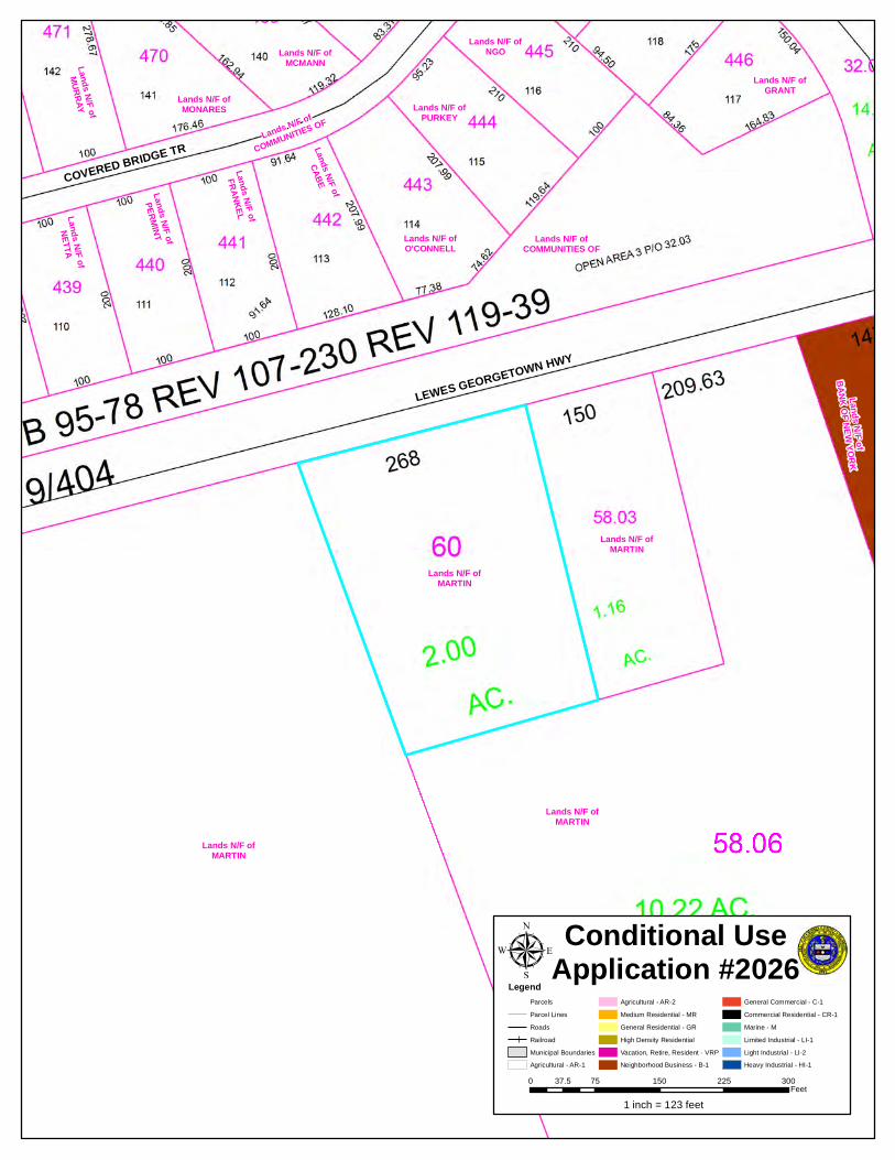
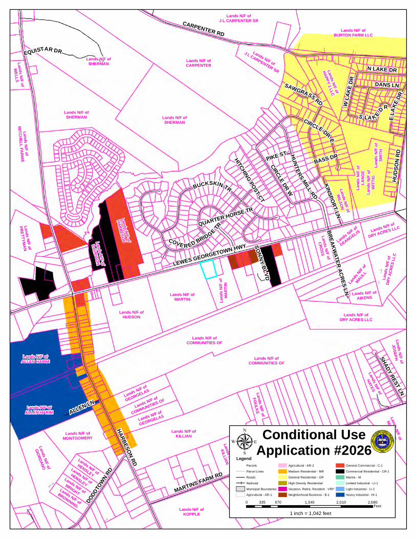
C/U #2026 – Cristian Omar Hernandez Perez and Terri L. Martin
An Ordinance to grant a Conditional Use of land in an AR-1 (Agricultural Residential District) for a home based business (auto repair, detailing, and auto resales) to be located on a certain parcel of land lying and being in Broadkill Hundred, Sussex County, containing 1.982 acres, more or less. The property is located south of Lewes-Georgetown Highway (Route 9) 0.8 mile east of Harbeson Road (Route 5) at Harbeson (911 Address: 26740 Lewes-Georgetown Highway, Harbeson) Tax Map I.D. 235-30.00-60.00.
The Commission found that the applicants provided a survey/site plan with their application which was filed on April 27, 2015.
The Commission found that DelDOT provided comments in the form of a Support Facilities Report on April 17, 2015 referencing that a traffic impact study was not recommended; and that the current Level of Service “E” of Route 9 will not change as a result of this application.
The Commission found that the Sussex Conservation District provided comments in the form of a memorandum on August 24, 2015 referencing that there is one soil type on this property; that the applicants will be required to follow recommended erosion and sediment control practices during any construction and to maintain vegetation; that no storm flood hazard areas are affected; that it is not likely that off-site drainage improvements will be necessary; that it is possible that on-site drainage improvements will be required; and that no tax ditches are affected.
The Commission found that the County Engineering Department Utility Planning Division provided comments in the form of a memorandum on August 24, 2015 referencing that the property is located in the North Coastal Planning Area; that the project is not capable of being annexed into a County operated Sanitary Sewer District at this time; that conformity to the North
County Council Report for 9-29-15 From Planning & Zoning Commission P a g e | 6
Coastal Planning Study will be required; that the proposed use is not in an area where the County has a schedule to provide sewer service at this time; and that a concept plan is not required.
The Commission found that the Department had received eight (8) form letters containing 38 signatures in opposition to this application expressing concerns that the applicants are currently operating the business illegally; that opposition is based on personal observations of the current activities; that the property has been occupied as a residential house; that automotive activities fall outside the intent of a home occupation; that the majority of the work is being performed outside of the home in plain view; that the applicant works on vehicles throughout the property, in the driveway and around the home; that several vehicles, sometimes numbering as many as 15, are parked throughout the property while waiting for repair or to be sold; that the business is out of character and incompatible with the surrounding community; that when the Trails of Beaver Creek was being developed and the homes were sold, those residents knew the neighboring property across Route 9 was a simple residential house; that if this Conditional Use is granted it would alter the neighborhood; that the property is not suited for automobile sales and repairs nor are there any other uses as intensive as a used car lot in the proximity of this parcel; that the property is not the appropriate size and not in the appropriate location to repair vehicles, store vehicles, and have customers gain access to the property; that currently, most visitors park their vehicles on the shoulder of Route 9; that the use would be better suited in a location where proper zoning already exists; that there is currently an automobile repair shop for sale less than ½ mile west on Route 9 that already has the appropriate zoning and is completely appropriate for this type of commercial activity; and that allowing a Conditional Use where a residential house has occupied for decades is inappropriate.
The Commission found that Terri Martin and Cristian Omar Hernandez Perez were present and stated in their presentation and in response to questions raised by the Commission that Ms. Martin owns the property and that Mr. Perez is the tenant; that there is a need for Spanish speaking operators of an auto-repair business; that there may be 4 or 5 vehicles for sale on the property; that the vehicles stopping along Route 9 are looking at the vehicles for sale; that repair work is being performed on the asphalt driveway; that they have a dumpster on site; that they intend to utilize the single car garage for repair work in the future; that business hours are from 7:00 a.m. to 5:00 p.m. Monday through Friday, with no weekend hours; that two or three family members work on the vehicles; that five family members live in the dwelling; that the site is in close proximity to a bird farm retail business, Old Wood woodworking business, the Donut Connection, an equipment rental business, and a business/industrial park; that Ms. Martin originally rented the dwelling with the intent of residential housing; and that Ms. Martin advised the Commission that the tenants are excellent tenants.
The Commission found that no parties appeared in support of or in opposition to this application.
On August 27, 2015 there was a motion by Mr. Johnson, seconded by Mr. Burton, and carried unanimously to defer action for further consideration. Motion carried 5 – 0.
C/U #2027 – SLC Homestead, LLC
An Ordinance to grant a Conditional Use of land in an AR-1 (Agricultural Residential District) for a home business – retail gun shop and gunsmithing to be located on a certain parcel of land lying and being in Dagsboro Hundred, Sussex County, containing 6.61 acres, more or less of a 14.04 acre tract. The property is located east of Iron Branch Road (Road 331)
County Council Report for 9-29-15 From Planning & Zoning Commission P a g e | 7
2,500 feet northeast of Main Street in Dagsboro (911 Address: 31005 Iron Branch Road, Dagsboro) Tax Map I.D. 233-11.00-17.00 (part of). The Commission found that the applicant provided a survey/site plan with the application filed on June 16, 2015. The Commission found that DelDOT provided comments in the form of a Support Facilities Report on May 12, 2015 referencing that a Traffic Impact Study was not recommended, and that the current Level of Service “C” of Iron Branch Road will not change as a result of this application. The Commission found that the Sussex Conservation District provided comments in the form of a memorandum on August 24, 2015 referencing that there are three soil types on this property; that the applicant will be required to follow recommended erosion and sediment control practices during construction and to maintain vegetation; that no storm flood hazard areas are affected; that no off-site drainage improvements will be required; that it is likely that on-site drainage improvements will be required; and that no tax ditches are affected. The Commission found that the County Engineering Department Utility Planning Division provided comments in the form of a memorandum on August 24, 2015 referencing that the property is located in the Dagsboro/Frankford Planning Area; that sewer service has not been extended to the area at this time; that conformity to the Dagsboro/Frankford Planning Study will be required; that when sewer service is provided to the area, connection is mandatory; that the County does not have a schedule to provide sewer service at this time; and that a concept plan is not required. The Commission found that Stuart Jones was present on behalf of his application and stated in his presentation and in response to questions raised by the Commission that he will be purchasing the property if the use is approved; that his business is currently located in Country Gardens commercial complex between Dagsboro and Millsboro; that he and his wife are living in a condominium and intend to purchase the farm and reside in the dwelling on this site; that the site has a nice home and out buildings and a working chicken house on the property; that he is intending to utilize the existing chicken house entrance for access for his customers; that the property will appear the same after the use is established, if you were to ride by; that he is proposing retail firearm sales and gunsmithing; that he has his Federal and State licenses; that the property already has a security system on the home, the garage and the out buildings; that gun safes will be utilized to store the firearms; that he is proposing business hours from 11:00 a.m. to 7:00 p.m. weekdays, and 10:00 a.m. to 4:00 p.m. Saturdays; that he may extend those hours during holidays; that no Sunday hours are proposed; that he hopes to hire an additional employee in the future; that he typically test firearms off site at approved ranges; that he does not build firearms from scratch, only from kits or by adding accessory parts, i.e. scopes; that he is purchasing the entire property, and hopes to lease the chicken house operation to a tenant operator. The Commission found that there were no parties present in support of or in opposition to this application. At the conclusion of the public hearings, the Commission discussed this application. On August 27, 2015 there was a motion by Mr. Smith, seconded by Mr. Ross, and carried unanimously to defer action for further consideration. Motion carried 5 - 0.
County Council Report for 9-29-15 From Planning & Zoning Commission P a g e | 8
On September 10, 2015 the Commission discussed this application under Old Business. Mr. Ross stated that he would move that the Commission recommend approval of Conditional Use No. 2027 for SLC Homestead, LLC to operate a retail gun shop with gunsmithing based upon the record made during the public hearing, and for the following reasons:
1. The use is for a retail gun shop and gunsmithing business located on 6.61 acres out of a 14.04 acre tract of land.
2. The use will exist within existing structures on the premises, and the applicants intend to
reside there while the business is underway.
3. The use is small in nature, and is very nearly a home occupation.
4. The use will not adversely affect neighboring properties or roadways. There are no residences that are close by to the proposed use.
5. The applicant has stated that there will not be a firing range located on the premises.
6. The applicant has stated that many of his customers include local law enforcement officers. As a result, the use has a public or semi-public character.
7. No parties appeared in opposition to the application.
8. This recommendation is subject to the following conditions: A. The applicant must comply with all Federal and State licenses and regulations for the
use. B. As stated by the applicant, there shall not be a firing range on the site. C. The hours of operation shall be 11:00 a.m. to 7:00 p.m. weekdays, 10:00 a.m. to 4:00
p.m. on Saturdays, and no Sunday hours. D. As stated by the applicant, the use shall be operated within the structures that currently
exist on the site as shown on the preliminary site plan submitted with the application. E. On lighted sign, not to exceed 32 square feet per side, shall be permitted. F. Security lights shall be installed. All lighting shall be downward screened so that it does
not shine onto neighboring properties or roadways. G. The Final Site Plan shall be subject to the review and approval of the Sussex County
Planning and Zoning Commission. Motion by Mr. Ross, seconded by Mr. Johnson, and carried unanimously to forward this application to the Sussex County Council with the recommendation that the application be approved for the reasons and with the conditions stated. Motion carried 4 – 0. Mr. Smith was absent. C/Z #1782 – Robert Atallian An Ordinance to amend the Comprehensive Zoning Map from an AR-1 (Agricultural Residential District) to a CR-1 (Commercial Residential District) for a certain parcel of land lying and being in Lewes and Rehoboth Hundred, Sussex County, containing 4.38 acres,
County Council Report for 9-29-15 From Planning & Zoning Commission P a g e | 9
more or less. The property is located south of Lewes-Georgetown Highway (Route 9) 615 feet west of Arabian Acres Road (Road 282) (911 Address: 18501 Stamper Drive, Lewes) Tax Map I.D. 334-4.00-88.00. The Commission found that the applicant provided a survey/site plan of the property with the application filed on June 15, 2015. The Commission found that DelDOT provided comments on December 11, 2014 in the form of a letter and Support Facilities Report referencing that the rezoning application can be considered without a Traffic Impact Study and that the need for a Traffic Impact Study will be evaluated when a subdivision or land development plan is proposed. The Commission found that the Sussex Conservation District provided comments on August 24, 2015 in the form of a memorandum referencing that there are two soil types on this property; that the applicant will be required to follow recommended erosion and sediment control practices during construction and to maintain vegetation; that no storm flood hazard areas or tax ditches are affected; that it is not likely that off-site drainage improvements will be required; and that it is possible that on-site drainage improvements will be required. The Commission found that the County Engineering Department Utility Planning Division provided comments on August 24, 2015 in the form of a memorandum referencing that the site is located in the North Coastal Planning Area; that conformity to the North Coastal Planning Study will be required; that the proposed change of zone is not in an area where the County has a schedule to provide sewer service at this time; and that a concept plan is not required. The Commission found that Robert Atallian and Bill Massey were present and stated in their presentation that historically this property has been used for an equestrian center, an eye glass business, and an approved antique store, which has an approved expansion for a produce market; that the application was filed to bring the property into the appropriate zoning category to establish the use as a permitted use, not requiring a conditional use; that there are several commercial and business uses across Route 9 and in close proximity to the site, referencing Bada Engineering, TR Roofing, Beaman’s Old and GNU Antiques, Building Supply Depot, Grissley’s, Millman’s Appliances, Steele’s Gun Shop, a beauty salon, Beracah Homes, a pet daycare, Hopkin’s Dairy Farm, and others; that the existing antique store was established by Conditional Use in 1995; that the produce stand expansion to the site was established Conditional Use in 2013; that they realize that all agency approvals are required before any additional expansions to the site; that two rezonings have been approved recently in the area; that this site has been used historically as a commercial use; that the neighboring property was recently denied for rezoning is a residential property; that the applicant would have to apply for additional conditional use application whenever he proposed to expand the business if the property remains AR-1; that they are only asking for conforming zoning to uses that have already been established; that the private drive easement on the property provides access to the Stamper properties to the rear; and that the two current uses of the property are the retail antiques and produce stand. The Commission found that the Mr. Atallian provided and displayed an aerial map of the area and a Google map of the area depicting some of the business/commercial uses in the area along Route 9. The Commission found that no parties appeared in support of or in opposition to this application.
County Council Report for 9-29-15 From Planning & Zoning Commission P a g e | 10
At the conclusion of the public hearings, the Commission discussed this application. On August 27, 2015 there was a motion by Mr. Johnson, seconded by Mr. Burton, and carried unanimously to defer action for further action. Motion carried 5 – 0. On September 10, 2015 the Commission discussed this application under Old Business. Mr. Johnson stated that he would move that the Commission recommend denial of Change of Zone NO. 1782 for Robert Atallian for a change in zone from AR-1 Agricultural Residential to CR-1 Commercial Residential based upon the record made during the public hearing, and for the following reasons:
1. Although the site has been approved for various conditional uses, those approvals are for limited purposes with conditions placed upon them. The applicant has not provided a clear reason to rezone the property to CR-1 Commercial Residential, other than vague possibilities of expanding the existing business. Such expansions could be sought through the Conditional Use process.
2. The site is not appropriate for CR-1 Commercial Residential zoning and the many permitted
uses that are allowed in that zoning district.
3. The rezoning is not compatible with the surrounding zoning, which is all AR-1 Agricultural Residential, subject to some limited conditional uses.
4. The traffic that could be generated from the potential permitted uses under a CR-1 Commercial Residential zoning is not compatible with the existing traffic conditions on Route 9.
5. The Commission recently recommended denial of a change in zone from AR-1 Agricultural Residential to B-1 Neighborhood Business for a nearby property. This recommendation of denial is consistent with the denial of that prior application.
6. There are residential properties to the rear of this site which are served by a private drive through this property. A rezoning to CR-1 Commercial Residential would be inconsistent with the adjacent homes and their only means of access.
7. There is simply not a sufficient basis in the record for rezoning this property from AR-1 Agricultural Residential to CR-1 Commercial Residential.
Motion by Mr. Johnson, seconded by Mr. Burton, and carried unanimously to forward this application to the Sussex County Council with the recommendation that the application be denied for the reasons stated. Motion carried 4 – 0. Mr. Smith was absent.
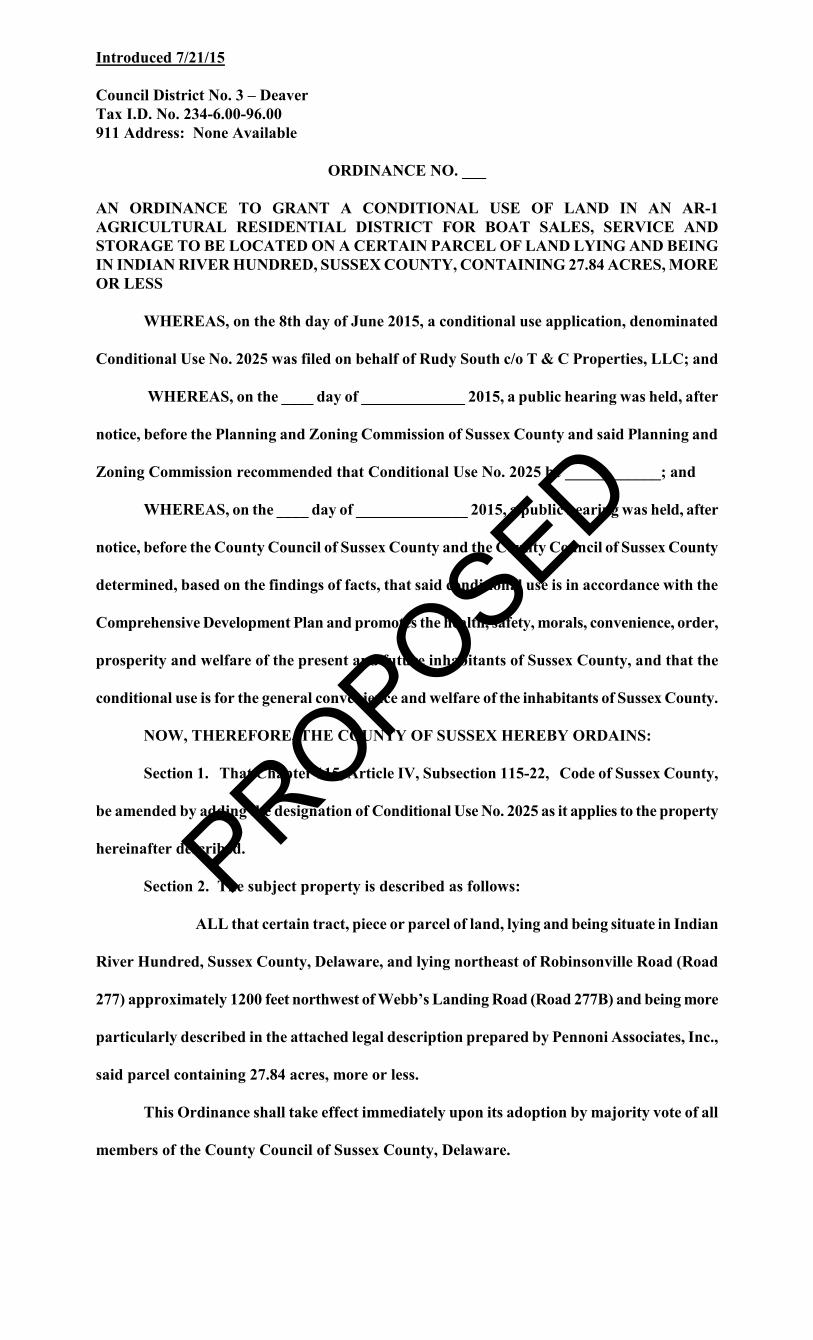
Introduced 7/21/15
Council District No. 3 – Deaver Tax I.D. No. 234-6.00-96.00 911 Address: None Available
ORDINANCE NO. ___
AN ORDINANCE TO GRANT A CONDITIONAL USE OF LAND IN AN AR-1 AGRICULTURAL RESIDENTIAL DISTRICT FOR BOAT SALES, SERVICE AND STORAGE TO BE LOCATED ON A CERTAIN PARCEL OF LAND LYING AND BEING IN INDIAN RIVER HUNDRED, SUSSEX COUNTY, CONTAINING 27.84 ACRES, MORE OR LESS
WHEREAS, on the 8th day of June 2015, a conditional use application, denominated
Conditional Use No. 2025 was filed on behalf of Rudy South c/o T & C Properties, LLC; and
WHEREAS, on the ____ day of _____________ 2015, a public hearing was held, after
notice, before the Planning and Zoning Commission of Sussex County and said Planning and
Zoning Commission recommended that Conditional Use No. 2025 be ____________; and
WHEREAS, on the ____ day of ______________ 2015, a public hearing was held, after
notice, before the County Council of Sussex County and the County Council of Sussex County
determined, based on the findings of facts, that said conditional use is in accordance with the
Comprehensive Development Plan and promotes the health, safety, morals, convenience, order,
prosperity and welfare of the present and future inhabitants of Sussex County, and that the
conditional use is for the general convenience and welfare of the inhabitants of Sussex County.
NOW, THEREFORE, THE COUNTY OF SUSSEX HEREBY ORDAINS:
Section 1. That Chapter 115, Article IV, Subsection 115-22, Code of Sussex County,
be amended by adding the designation of Conditional Use No. 2025 as it applies to the property
hereinafter described.
Section 2. The subject property is described as follows:
ALL that certain tract, piece or parcel of land, lying and being situate in Indian
River Hundred, Sussex County, Delaware, and lying northeast of Robinsonville Road (Road
277) approximately 1200 feet northwest of Webb’s Landing Road (Road 277B) and being more
particularly described in the attached legal description prepared by Pennoni Associates, Inc.,
said parcel containing 27.84 acres, more or less.
This Ordinance shall take effect immediately upon its adoption by majority vote of all
members of the County Council of Sussex County, Delaware.
PROPOSED
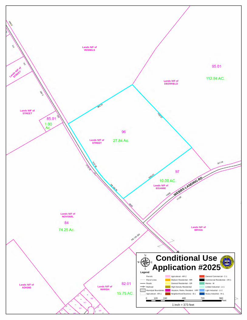
ROBINSONVILLE RD
WEBBS LANDING RD
Lands N/F ofNOVOSEL
Lands N/F ofVESSELS
Lands N/F ofDEERFIELD
Lands N/F ofBRYAN
Lands N/F ofSTREET
Lands N/F ofMARSH
Lands N/F ofBRYAN
Lands N/F ofADKINS
Lands N/F ofSTREET
Lands N/F ofEIGHMIE
Lands N/F of
STREET
LegendParcelsParcel LinesRoadsRailroadMunicipal BoundariesAgricultural - AR-1
Agricultural - AR-2Medium Residential - MRGeneral Residential - GRHigh Density ResidentialVacation, Retire, Resident - VRPNeighborhood Business - B-1
General Commercial - C-1Commercial Residential - CR-1Marine - MLimited Industrial - LI-1Light Industrial - LI-2Heavy Industrial - HI-1
µ Conditional UseApplication #2025
0 240 480 720 960120Feet
1 inch = 373 feet
ROBINSONVILLE RD
AINTREE DR
FOX RN
WARD R
D
HARTS RD
WEBBS LANDING RD
WIL KING RD
KENDALE RD
JOHN
J WI
LLIAM
S HWY
WILLOW LN
CEDAR GROVE RD
ALMW
ICK LN
HARBURG DR
HEATHER DR
AUTUMNWOOD WAY
ANCIENT OAK DR
WATERFORD DR
PICKWICKE RD
B ERNAR
D DR
MISTY LN
LONG LN
BELMON TE DR
JOLYNS WAY
ALDERLEAF DR
WANDRING LN
BLIZZARD LN
DURHAM CT
ALMAS WAY
DOBERMAN DR
E CONLEY CIRAPPLEWOOD LN
GRACIE LN
HARMON Y RD
BL AIR CT
DEDE
LN
AMBERWOODWAY
WARWICK CTMARIMAR CT
Lands N/F ofVESSELS
Lands N/F ofBRYAN
Lands N/F ofADKINS
Lands N/F ofDEERFIELD
Lands N/F ofNOVOSEL
Lands N/F of
Lands N/F ofTANA
Land
s N/F
ofTO
WNSE
ND
Lands N/F ofSTREET
Lands N/F ofSTREET
Lands N/F ofCOASTAL FARMS-
Lands N/F of
BRYAN
Lands N/F of
Lands
N/F of
HILL
Lands N/F ofSTREET
Land
s N/F
ofCO
OPER
Lands N/F ofTHE RETREAT AT
Lands N/F of
STREET
Lands N/F of
HART
Lands N/F ofHILL
Lands N/F of
STREET
Lands N/F of
WRIGHT
Lands N/F of
WRIGHT
Lands N/F of
CHAPEL GREEN
Lands N/F of
ROSELands N/F of
HART
Land
s N/F
ofST
REET
Lands N/F of
MARSH
Land
s N/F
ofJO
NES
Lands N/F of
CHURCH
Lands N/F ofWANDENDALE
Lands
N/F of
ADKINS
Lands N/F ofHILL
Lands
N/F of
MARSHLands N/F of
BARLOW
Lands N/F ofCHAPEL GREEN
Lands N/F of
MILLMAN
Land
s N/F
ofCO
LLINS
Lands N/F ofBROWNLOWE
Lands N/F of
NOVOSEL
Lands N/F ofWALLS
Lands N/F of
BISHOFF
Lands N/F of
EIGHMIE
Lands N/F of
STREETT
Lands N/F ofWHARTON
Land
s N/F
ofBO
YER
Lands N/F ofKING
Land
s N/F
ofHIL
L
Lands N/F of
SMI RT 24
Lands N/F of
EDWARDS
Lands N/F ofREINDLLands N/F of
BROWNLOWELands N/F of
BROWNLOWE
Lands N/F of
STREET
LegendParcelsParcel LinesRoadsRailroadMunicipal BoundariesAgricultural - AR-1
Agricultural - AR-2Medium Residential - MRGeneral Residential - GRHigh Density ResidentialVacation, Retire, Resident - VRPNeighborhood Business - B-1
General Commercial - C-1Commercial Residential - CR-1Marine - MLimited Industrial - LI-1Light Industrial - LI-2Heavy Industrial - HI-1
µ Conditional UseApplication #2025
0 670 1,340 2,010 2,680335Feet
1 inch = 1,042 feet
ROBINSONVILLE RD
WEBBS LANDING RD
Lands N/F ofNOVOSEL
Lands N/F ofVESSELS
Lands N/F ofDEERFIELD
Lands N/F ofBRYAN
Lands N/F ofSTREET
Lands N/F ofMARSH
Lands N/F ofBRYAN
Lands N/F ofADKINS
Lands N/F ofSTREET
Lands N/F ofEIGHMIE
Lands N/F of
STREET
Source: Esri, DigitalGlobe, GeoEye, Earthstar Geographics, CNES/Airbus DS,USDA, USGS, AEX, Getmapping, Aerogrid, IGN, IGP, swisstopo, and the GISUser Community
LegendParcelsParcel LinesRoadsRailroadMunicipal BoundariesAgricultural - AR-1
Agricultural - AR-2Medium Residential - MRGeneral Residential - GRHigh Density ResidentialVacation, Retire, Resident - VRPNeighborhood Business - B-1
General Commercial - C-1Commercial Residential - CR-1Marine - MLimited Industrial - LI-1Light Industrial - LI-2Heavy Industrial - HI-1
µ Conditional UseApplication #2025
0 240 480 720 960120Feet
1 inch = 373 feet
Introduced 7/21/15
Council District No. 3 – Deaver Tax I.D. No. 235-30.00-60.00 911 Address: 26740 Lewes-Georgetown Highway, Harbeson
ORDINANCE NO. ___
AN ORDINANCE TO GRANT A CONDITIONAL USE OF LAND IN AN AR-1 AGRICULTURAL RESIDENTIAL DISTRICT FOR A HOME BASED BUSINESS (AUTO REPAIR, DETAILING, AND AUTO RESALES) TO BE LOCATED ON A CERTAIN PARCEL OF LAND LYING AND BEING IN BROADKILL HUNDRED, SUSSEX COUNTY, CONTAINING 1.982 ACRES, MORE OR LESS
WHEREAS, on the 9th day of June 2015, a conditional use application, denominated
Conditional Use No. 2026 was filed on behalf of Cristian Omar Hernandez Perez and Terri L.
Martin; and
WHEREAS, on the ____ day of _____________ 2015, a public hearing was held, after
notice, before the Planning and Zoning Commission of Sussex County and said Planning and
Zoning Commission recommended that Conditional Use No. 2026 be ____________; and
WHEREAS, on the ____ day of ______________ 2015, a public hearing was held, after
notice, before the County Council of Sussex County and the County Council of Sussex County
determined, based on the findings of facts, that said conditional use is in accordance with the
Comprehensive Development Plan and promotes the health, safety, morals, convenience, order,
prosperity and welfare of the present and future inhabitants of Sussex County, and that the
conditional use is for the general convenience and welfare of the inhabitants of Sussex County.
NOW, THEREFORE, THE COUNTY OF SUSSEX HEREBY ORDAINS:
Section 1. That Chapter 115, Article IV, Subsection 115-22, Code of Sussex County,
be amended by adding the designation of Conditional Use No. 2026 as it applies to the property
hereinafter described.
Section 2. The subject property is described as follows:
ALL that certain tract, piece or parcel of land, lying and being situate in
Broadkill Hundred, Sussex County, Delaware, and lying south of Lewes-Georgetown Highway
(Route 9) 0.8 mile east of Harbeson Road (Route 5) at Harbeson and being more particularly
described as follows:
BEGINNING at an iron pipe on the southerly right-of-way of Lewes-
Georgetown Highway (Route 9), a corner for these subject lands and other lands of Terri L.
Martin; thence North 84°28′28″ East 264.88 feet along the southerly right-of-way of Lewes-
Georgetown Highway to an iron pipe; thence by and along other lands of Terri L. Martin the
following three (3) courses:
PROPOSED

South 05°00′00″ East 350.70 feet to a point; and
South 84°43′59″ West 228.38 feet to an iron pipe; and
North 10°58′00″ West 351.24 feet;
to the point and place of beginning, said parcel containing 1.982 acres, more or less.
This Ordinance shall take effect immediately upon its adoption by majority vote of all
members of the County Council of Sussex County, Delaware.
PROPOSED
LEWES GEORGETOWN HWY
COVERED BRIDGE TR
Lands N/F ofMARTIN
Lands N/F ofMARTIN
Lands N/F ofMARTIN
Lands N/F ofCOMMUNITIES OF
Lands N/F ofMARTIN
Lands N/F ofO'CONNELL
Lands N/F ofPURKEY
Lands N/F of
CABE
Lands N/F of
FRANKEL
Lands N/F of
PERMINT
Lands N/F ofNETTA
Lands N/F ofGRANT
Lands N/F ofMONARES
Lands N/F of
COMMUNITIES OF
Lands N/F ofNGO
Lands N/F ofMURRAY
Lands N/F ofMCMANN
Lands N/F ofBANK OF NEW YORK
LegendParcelsParcel LinesRoadsRailroadMunicipal BoundariesAgricultural - AR-1
Agricultural - AR-2Medium Residential - MRGeneral Residential - GRHigh Density ResidentialVacation, Retire, Resident - VRPNeighborhood Business - B-1
General Commercial - C-1Commercial Residential - CR-1Marine - MLimited Industrial - LI-1Light Industrial - LI-2Heavy Industrial - HI-1
µ Conditional UseApplication #2026
0 75 150 225 30037.5Feet
1 inch = 123 feet
HARBESON RD
CARPENTER RD
MARTINS FARM RD
LEWES GEORGETOWN HWY
BUCKSKIN TR
HUDS
ON R
DHUNTERS MILL RD
SAWGRASS RD
CIRCLE DR W
DODD
TOWN R
DCIRCLE DR E
EQUISTAR DR
DANS LN
ELAK
E DR
N LAKE DR
COVE R ED BRIDGE TR
S LA K E DR
ALLEN LN
KINSPORT LN
DEVINE WAY
SHADY REST LN
W LA
KE D
R
PIKE ST
BREAKWATER ACRES LN
FEATHER BED LN
BASS DRHITCHING POST CTSONNY BLVD
QUARTER HORSE TR
Lands N/F ofCARPENTER
Lands N/F ofSHERMAN
Lands N/F ofSHERMAN
Lands N/F ofPECK
Lands N/F ofCOMMUNITIES OF
Lands N/F ofSHERMAN
Lands N/F ofCOMMUNITIES OF
Lands N/F ofKILLIAN
Lands N/F ofALLEN HARIM
Lands N/F ofBURTON FARM LLC
Lands N/F ofMARTIN
Lands N/F ofHUDSON
Lands N/F ofHARBESON FARM
Lands N/F ofKOPPLE
Land
s N/F
ofWI
TTIG
Land
s N/F
ofLA
NGE
Land
s N/F
ofSM
ITH
Lands N/F ofALLEN HARIM
Lands N/F of
GIORDANO
Lands N/F ofMITCHELL FARMS
Lands N/F ofDRY ACRES LLC
Lands N/F ofJ L CARPENTER SR
Lands N/F ofMONTGOMERY
Lands N/F of
HARBESON
Lands N/F ofPRETTYMAN
Lands N/F of
HAPPY 1 LLC
Lands N/F of
MALONEY
Land
s N/F
ofDR
Y ACR
ES LL
C
Land
s N/F
ofMA
RTIN
Lands N/F of
DEANGELIS
Lands N/F of
GEORGELAS
Lands N/F of
KILLIAN
Lands
N/F of
MAULL
Lands N/F of
GEORGELAS
Lands N/F ofJOSEPH
Lands N/F of
J L CARPENTER SR
Lands N/F of
DRY ACRES LLC
Lands N/F of
KOPPLE
Lands N/F of
WILSON
Lands N/F of
DAVIDSON
Lands N/F ofFOULKE
Lands N/F of
HAYES
Lands N/F of
COMMUNITIES OF
Lands N/F ofAIKENS
Lands N/F ofWELLS
Lands N/F of
REIMER
Lands N/F ofCROSS
Lands N/F ofWRIGHT
Lands N/F ofHENSLEY
Lands N/F ofHENSLEY
Lands N/F ofBROWNING
LegendParcelsParcel LinesRoadsRailroadMunicipal BoundariesAgricultural - AR-1
Agricultural - AR-2Medium Residential - MRGeneral Residential - GRHigh Density ResidentialVacation, Retire, Resident - VRPNeighborhood Business - B-1
General Commercial - C-1Commercial Residential - CR-1Marine - MLimited Industrial - LI-1Light Industrial - LI-2Heavy Industrial - HI-1
µ Conditional UseApplication #2026
0 670 1,340 2,010 2,680335Feet
1 inch = 1,042 feet
LEWES GEORGETOWN HWY
COVERED BRIDGE TR
Lands N/F ofMARTIN
Lands N/F ofMARTIN
Lands N/F ofMARTIN
Lands N/F ofCOMMUNITIES OF
Lands N/F ofMARTIN
Lands N/F ofO'CONNELL
Lands N/F ofPURKEY
Lands N/F of
CABE
Lands N/F of
FRANKEL
Lands N/F of
PERMINT
Lands N/F ofNETTA
Lands N/F ofGRANT
Lands N/F ofMONARES
Lands N/F of
COMMUNITIES OF
Lands N/F ofNGO
Lands N/F ofMURRAY
Lands N/F ofMCMANN
Lands N/F ofBANK OF NEW YORK
Source: Esri, DigitalGlobe, GeoEye, Earthstar Geographics, CNES/Airbus DS,USDA, USGS, AEX, Getmapping, Aerogrid, IGN, IGP, swisstopo, and the GISUser Community
LegendParcelsParcel LinesRoadsRailroadMunicipal BoundariesAgricultural - AR-1
Agricultural - AR-2Medium Residential - MRGeneral Residential - GRHigh Density ResidentialVacation, Retire, Resident - VRPNeighborhood Business - B-1
General Commercial - C-1Commercial Residential - CR-1Marine - MLimited Industrial - LI-1Light Industrial - LI-2Heavy Industrial - HI-1
µ Conditional UseApplication #2026
0 75 150 225 30037.5Feet
1 inch = 123 feet
Introduced 07/21/15
Council District No. 5 – Arlett Tax Map I.D. 233-11.00-17.00 (Part of) 911 Address: 31005 Iron Branch Road, Dagsboro
ORDINANCE NO. _____
AN ORDINANCE TO GRANT A CONDITIONAL USE OF LAND IN AN AR-1 AGRICULTURAL RESIDENTIAL DISTRICT FOR A HOME BUSINESS – RETAIL GUN SHOP AND GUNSMITHING TO BE LOCATED ON A CERTAIN PARCEL OF LAND LYING AND BEING IN DAGSBORO HUNDRED, SUSSEX COUNTY, CONTAINING 6.61 ACRES, MORE OR LESS OF A 14.04 ACRE TRACT
WHEREAS, on the 15th day of June 2015, a conditional use application,
denominated Conditional Use No. 2027 was filed on behalf of SLC Homestead, LLC; and
WHEREAS, on the _____ day of ____________ 2015, a public hearing was held,
after notice, before the Planning and Zoning Commission of Sussex County and said
Planning and Zoning Commission recommended that Conditional Use No. 2027 be
____________; and
WHEREAS, on the _____day of ____________ 2015, a public hearing was held,
after notice, before the County Council of Sussex County and the County Council of Sussex
County determined, based on the findings of facts, that said Conditional Use is in
accordance with the Comprehensive Development Plan and promotes the health, safety,
morals, convenience, order, prosperity and welfare of the present and future inhabitants of
Sussex County, and that the Conditional Use is for the general convenience and welfare of
the inhabitants of Sussex County.
NOW, THEREFORE, THE COUNTY OF SUSSEX HEREBY ORDAINS:
Section 1. That Chapter 115, Article IV, Subsection 115-22, Code of Sussex
County, be amended by adding the designation of Conditional Use No. 2027 as it applies to
the property hereinafter described.
Section 2. The subject property is described as:
All that certain tract, piece or parcel of land, lying and being situate in Dagsboro
Hundred, Sussex County, Delaware, and lying east of Iron Branch Road (Road 331) 2,500
feet northeast of Main Street in Dagsboro, and being more particularly described as
follows:
BEGINNING at a concrete marker on the easterly right-of-way of Iron Branch
Road (Road 331), a corner for these subject lands and lands, now or formerly, of Debra
Marie Baker; thence North 8715'00" East 557.50 feet along said Baker lands to a point;
thence across lands of John and Carol Evans the following three (3) courses:
PROPOSED
South 850'41" East 337.40 feet to a point; and
South 8109'19" West 25.96 feet to a point; and
South 812'21" East 139.14 feet to a point;
thence South 8149'29" West 565.83 feet along lands, now or formerly, of James A. Burton
to a point on the easterly right-of-way of Iron Branch Road; thence North 332'26" West
531.27 feet along the easterly right-of-way of Iron Branch Road to the point and place of
beginning, said parcel containing 6.61 acres, more or less, of a 14.04 acre tract.
This Ordinance shall take effect immediately upon its adoption by majority vote of
all members of the County Council of Sussex County, Delaware.
PROPOSED

IRON
BRA
NCH
RD
Lands N/F ofBURTON
Lands N/F ofSTEEN
Lands N/F ofEVANS
Lands N/F ofMATTHES
Lands N/F ofDAVIDSON
Lands N/F ofCEMETERY
Lands N/F ofLAWSON
Lands N/F ofDAVIDSON
Lands N/F of
Lands N/F ofCORDREY
Land
s N/F
ofAD
KINS
Lands N/F ofBAKER
Lands N/F ofMATTHES
Lands N/F ofBRASURE
Lands N/F ofAKERS
LegendParcelsParcel LinesRoadsRailroadMunicipal BoundariesAgricultural - AR-1
Agricultural - AR-2Medium Residential - MRGeneral Residential - GRHigh Density ResidentialVacation, Retire, Resident - VRPNeighborhood Business - B-1
General Commercial - C-1Commercial Residential - CR-1Marine - MLimited Industrial - LI-1Light Industrial - LI-2Heavy Industrial - HI-1
µ Conditional UseApplication #2027
0 160 320 480 64080Feet
1 inch = 250 feet

MAIN ST
IRON
BRA
NCH
RD
PINEY NECK RD
13U-8
BUNTING RD
FIRE TO
WER RD
HUDSON RD
VINES CREEK RD
CLAYTON ST
NEW ST
POWE
R PL
ANT R
D
DEER
RN
ARMORY RD
WAPLES ST
SUSSEX ST
DAGSBORO RD
TIMMON S ST
HELM ST
BRITT
S LN
TRAIN LN
RAILROAD AV
PENNEY LN
SWAMP RD
STONE LN
IR PL
ANT R
D
LINGO ST
OAK LANDING RD
JONAH WAYWARRINGTON ST
DE ER HAVEN LN
CANNON ST
CHAPEL LN
CANA
L ST
COLE DR
W DIAMOND ST
HICKORY LN
IRISH LN
RACE CAR DR
ELIZABETHDR
DEER RN
RAILROAD AV
SWAM
P RD
Lands N/F ofRIVERVIEW
Lands N/F ofDAVIDSON
Lands N/F ofDAISEY
Lands N/F ofSUSSEX COUNTY
Lands N/F ofINDIAN RIVER
Lands N/F ofEASHUM
Lands N/F ofBURTON
Lands N/F ofHKS PROPERTIES
Lands N/F ofDAVIDSON
Lands N/F ofINDIAN RIVER
Lands
N/F of
HALL
Land
s N/F
ofHIL
LELands N/F of
DAVIDSON
Lands N/F ofSTEEN
Lands N/F of
DAVIDSON
Land
s N/F
ofLA
WSON
Lands N/F of
ADKINS
Land
s N/F
ofHA
LL Lands N/F ofADKINS
Lands N/F ofCLOGG
Lands N/F ofHALL
Lands N/F ofINDIAN RIVER
Lands N/F of
INDIAN RIVERLands
N/F of
BUNTING
Lands N/F of
P & J TINGLE
Lands N/F of
CHAPMAN
Lands N/F ofMILLMAN
Land
s N/F
ofST
EEN F
AMILY
LLC
Lands N/F of
Lands N/F of
HALL
Lands N/F of
BIRELEY
Lands N/F of
TINGLE
Lands N/F ofHKS PROPERTIES
Lands N/F ofLYNCH
Lands N/F of
HKS PROPERTIES
Lands N/F of
TINGLE
Lands N/F ofEVANS
Lands N/F ofSAGERS
Lands N/F ofCOX
Lands N/F ofHILL
Lands N/F ofPARSONS FAMILY
Lands
N/F of
GERKEN
Lands N/F ofMATTHES
Lands N/F of
SUSSEX COUNTY
Lands N/F of
WELSH
Lands N/F ofHALL
Lands N/F ofDAVIDSON
Lands N/F of
SUSSEX COUNTY
Lands N/F of
SAGERS
Lands N/F ofLYNCH
Lands N/F of
DELAWARE
Lands N/F of
THOMAS
Lands N/F ofDAVIDSON
Lands N/F ofNULLET
Lands N/F ofADKINS
Lands
N/F of
ADAMSLands N/F of
BRASURE
Lands N/F of
SHAUBACH
Lands N/F of
MBG-1
Lands N/F ofHANDY
Lands N/F of
TRUITT
Lands N/F of
DAGSBORO TOWN
Lands N/F of
LYNCH
Lands N/F ofINDIAN RIVER
Lands N/F of
INDIAN RIVER
Lands N/F ofTIMMONS
Land
s N/F
ofDR
APER
LegendParcelsParcel LinesRoadsRailroadMunicipal BoundariesAgricultural - AR-1
Agricultural - AR-2Medium Residential - MRGeneral Residential - GRHigh Density ResidentialVacation, Retire, Resident - VRPNeighborhood Business - B-1
General Commercial - C-1Commercial Residential - CR-1Marine - MLimited Industrial - LI-1Light Industrial - LI-2Heavy Industrial - HI-1
µ Conditional UseApplication #2027
0 670 1,340 2,010 2,680335Feet
1 inch = 1,042 feet
IRON
BRA
NCH
RD
Lands N/F ofBURTON
Lands N/F ofSTEEN
Lands N/F ofEVANS
Lands N/F ofMATTHES
Lands N/F ofDAVIDSON
Lands N/F ofCEMETERY
Lands N/F ofLAWSON
Lands N/F ofDAVIDSON
Lands N/F of
Lands N/F ofCORDREY
Land
s N/F
ofAD
KINS
Lands N/F ofBAKER
Lands N/F ofMATTHES
Lands N/F ofBRASURE
Lands N/F ofAKERS
Source: Esri, DigitalGlobe, GeoEye, Earthstar Geographics, CNES/Airbus DS,USDA, USGS, AEX, Getmapping, Aerogrid, IGN, IGP, swisstopo, and the GISUser Community
LegendParcelsParcel LinesRoadsRailroadMunicipal BoundariesAgricultural - AR-1
Agricultural - AR-2Medium Residential - MRGeneral Residential - GRHigh Density ResidentialVacation, Retire, Resident - VRPNeighborhood Business - B-1
General Commercial - C-1Commercial Residential - CR-1Marine - MLimited Industrial - LI-1Light Industrial - LI-2Heavy Industrial - HI-1
µ Conditional UseApplication #2027
0 160 320 480 64080Feet
1 inch = 250 feet

Introduced 07/21/15
Council District No. 3 – Deaver Tax Map I.D. No. 334-4.00-88.00 911 Address: 18501 Stamper Drive, Lewes
ORDINANCE NO. ____
AN ORDINANCE TO AMEND THE COMPREHENSIVE ZONING MAP OF SUSSEX COUNTY FROM AN AR-1 AGRICULTURAL RESIDENTIAL DISTRICT TO A CR-1 COMMERCIAL RESIDENTIAL DISTRICT FOR A CERTAIN PARCEL OF LAND LYING AND BEING IN LEWES AND REHOBOTH HUNDRED, SUSSEX COUNTY, CONTAINING 4.38 ACRES, MORE OR LESS
WHEREAS, on the 15th day of June 2015, a zoning application, denominated Change
of Zone No. 1782 was filed on behalf of Robert Atallian; and
WHEREAS, on the ______ day of ______________ 2015, a public hearing was held,
after notice, before the Planning and Zoning Commission of Sussex County and said
Planning and Zoning Commission recommended that Change of Zone No. 1782 be
____________; and
WHEREAS, on the ______ day of ______________ 2015, a public hearing was held,
after notice, before the County Council of Sussex County and the County Council of Sussex
County has determined, based on the findings of facts, that said change of zone is in
accordance with the Comprehensive Development Plan and promotes the health, safety,
morals, convenience, order, prosperity and welfare of the present and future inhabitants of
Sussex County,
NOW, THEREFORE, THE COUNTY OF SUSSEX COUNTY ORDAINS:
Section 1. That Chapter 115, Article II, Subsection 115-7, Code of Sussex County,
be amended by deleting from the Comprehensive Zoning Map of Sussex County the zoning
classification of [AR-1 Agricultural Residential District] and adding in lieu thereof the
designation of CR-1 Commercial Residential District as it applies to the property hereinafter
described.
Section 2. The subject property is described as follows:
All that certain tract, piece or parcel of land lying and being situate in Lewes and
Rehoboth Hundred, Sussex County, Delaware, and lying south of Lewes-Georgetown
Highway (Route 9) 615 feet west of Arabian Acres Road (Road 282) and being more
particularly described in Deed Book 2344 Page 265 in the Office of the Recorder of Deeds in
and for Sussex County, said parcel containing 4.38 acres, more or less.
This Ordinance shall take effect immediately upon its adoption by majority
vote of all members of the County Council of Sussex County, Delaware.
PROPOSED

125
ARABIAN CORNERS PB 8-696
88
15.63 Ac.
32
100 89
100
125
125
88
14
15
100
100 87
125
13
1112
86100
4.38Ac.
130
5
130
BON-AIRE PB 8-423150
31.48 Ac.
31.01
31.02
2
Ac.2.03
3251
C
30.023.09 Ac.
10
PB 86-290
16
150.01
14
150
79
61 9
241.08
150.01
273.97
12
80
150.01
10
81
60 7
228.56
59 5
218.32
150.01
8
82
6
83
3
226.23
254.34
58
4
150.01
285.84
156265.33
1.71 AC.
137
2
571.84
57
155.43
150.01
275.95277.94
297.92
1.00Ac. 281.90283.89
84
100
130
33
102.4
1652
85
286
317 150
150
150
150
150
15063
295345
53
37.02
165
100
137
100 90
108.2150
13070
154
125
84.01
PB 108-204
31.031.21Ac.
285.91184.21
71.34
PB 106-244
30.052.00 Ac.1
208.64
30.29
122.5
5167.23
30.311.34 Ac.
31
31.0431.05
31.06
150
213.16
Ac.1.40
Ac.1.48 Ac.
1.39
1.40 Ac.
1
12
3
PB 123-92
313.24
236.48
273.25
334.64
379.75
50
RT. 9/404
STAMPER DR
RAVENS WAY
LEWES GEORGETOWN HWY
Lands N/F ofDERRICKSON
Lands N/F ofATALLIAN
Lands N/F ofHAUER
Lands N/F ofGREELEY
Lands N/F ofBLUE LION
Lands N/F ofLOYAL
Lands N/F ofCLOUTING
Lands N/F ofIRWIN
Lands N/F ofSTAMPER
Lands N/F ofHUDSON
Lands N/F ofESPOSITO
Lands N/F ofCRISPIN
Lands N/F ofKUCHARIK
Lands N/F ofLODGE
Lands N/F ofGLANDEN Lands N/F of
CHRISTMAN
Lands N/F ofBELAY
Lands N/F ofBEAMAN
Lands N/F of
KELLY
Lands N/F of
CASHDOLLAR
Lands N/F of
SUNLIGHT VENTURES
Lands N/F of
BRUFFEY
Lands N/F ofWELCH
Lands N/F ofBOOROS
Lands N/F ofFRAZIER
Lands N/F ofMENARD
Lands N/F ofWISNIEWSKI
LegendTax ParcelsRoadsRailroadMunicipal BoundariesAgricultural - AR-1Agricultural - AR-2
Medium Residential - MRGeneral Residential - GRHigh Density ResidentialVacation, Retire, Resident - VRPNeighborhood Business - B-1General Commercial - C-1
Commercial Residential - CR-1Marine - MLimited Industrial - LI-1Light Industrial - LI-2Heavy Industrial - HI-1
µ Change of ZoneApplication #1782
0 100 200 300 40050Feet
1 inch = 160 feet
FISHER RD
JOSE
PHS R
D
LOG CABIN HILL RD
LEWES GEORGETOWN HWY
SWEETBRIAR RD
ARABIAN ACRES RD
DAIRY FARM RD
PERSIM MON RD
MAPLE RD
FOXFIELD LN
PINE TREE RD
OAKRIDGE DR
RAVENSWAY
PINETOWN RD
MEADOWRIDGE LN
TENNESSEE WALK
BEECH RD
STAMPER DRFIELD RD
ELM RD
HICKORY RD
SUNS
ET R
DLAWRENCE CIR
CANTE
R AVLITTLE
G OAT LNASH RD
BRIN
TON
BLVDFIELD RD
FISHER RD
Lands N/F ofJOSEPH
Lands N/F ofCAREY
Lands N/F ofHOPKINS
Lands N/F ofRED MILL POND
Lands N/F ofLYON'S LLC
Lands N/F ofBEATS
Lands N/F ofMARTIN
Lands N/F of
TALL PINES
Lands N/F ofLEACH
Lands N/F ofGREEN
Lands N/F ofGEORGE W HOPKINS
Lands N/F ofMCHUGH
Land
s N/F
ofWO
LFE
Lands N/F ofCOOL SPRING
Lands N/F ofTRIPLE B FARMS
Land
s N/F
ofES
POSIT
O
Land
s N/F
ofDE
RRIC
KSON
Lands N/F ofBRENNER
Lands N/F ofSHORT
Lands N/F of
GRIFFIN
Lands N/F ofCHURCH
Land
s N/F
ofBE
RRY
LegendTax ParcelsRoadsRailroadMunicipal BoundariesAgricultural - AR-1Agricultural - AR-2
Medium Residential - MRGeneral Residential - GRHigh Density ResidentialVacation, Retire, Resident - VRPNeighborhood Business - B-1General Commercial - C-1
Commercial Residential - CR-1Marine - MLimited Industrial - LI-1Light Industrial - LI-2Heavy Industrial - HI-1
µ Change of ZoneApplication #1782
0 670 1,340 2,010 2,680335Feet
1 inch = 1,042 feet
125
ARABIAN CORNERS PB 8-696
88
15.63 Ac.
32
100 89
100
125
125
88
14
15
100
100 87
125
13
1112
86100
4.38Ac.
130
5
130
BON-AIRE PB 8-423150
31.48 Ac.
31.01
31.02
2
Ac.2.03
3251
C
30.023.09 Ac.
10
PB 86-290
16
150.01
14
150
79
61 9
241.08
150.01
273.97
12
80
150.01
10
81
60 7
228.56
59 5
218.32
150.01
8
82
6
83
3
226.23
254.34
58
4
150.01
285.84
156265.33
1.71 AC.
137
2
571.84
57
155.43
150.01
275.95277.94
297.92
1.00Ac. 281.90283.89
84
100
130
33
102.4
1652
85
286
317 150
150
150
150
150
15063
295345
53
37.02
165
100
137
100 90
108.2150
13070
154
125
84.01
PB 108-204
31.031.21Ac.
285.91184.21
71.34
PB 106-244
30.052.00 Ac.1
208.64
30.29
122.5
5167.23
30.311.34 Ac.
31
31.0431.05
31.06
150
213.16
Ac.1.40
Ac.1.48 Ac.
1.39
1.40 Ac.
1
12
3
PB 123-92
313.24
236.48
273.25
334.64
379.75
50
RT. 9/404
STAMPER DR
RAVENS WAY
LEWES GEORGETOWN HWY
Lands N/F ofDERRICKSON
Lands N/F ofATALLIAN
Lands N/F ofHAUER
Lands N/F ofGREELEY
Lands N/F ofBLUE LION
Lands N/F ofLOYAL
Lands N/F ofCLOUTING
Lands N/F ofIRWIN
Lands N/F ofSTAMPER
Lands N/F ofHUDSON
Lands N/F ofESPOSITO
Lands N/F ofCRISPIN
Lands N/F ofKUCHARIK
Lands N/F ofLODGE
Lands N/F ofGLANDEN Lands N/F of
CHRISTMAN
Lands N/F ofBELAY
Lands N/F ofBEAMAN
Lands N/F of
KELLY
Lands N/F of
CASHDOLLAR
Lands N/F of
SUNLIGHT VENTURES
Lands N/F of
BRUFFEY
Lands N/F ofWELCH
Lands N/F ofBOOROS
Lands N/F ofFRAZIER
Lands N/F ofMENARD
Lands N/F ofWISNIEWSKI
Source: Esri, DigitalGlobe, GeoEye, Earthstar Geographics, CNES/Airbus DS,USDA, USGS, AEX, Getmapping, Aerogrid, IGN, IGP, swisstopo, and the GISUser Community
LegendTax ParcelsRoadsRailroadMunicipal BoundariesAgricultural - AR-1Agricultural - AR-2
Medium Residential - MRGeneral Residential - GRHigh Density ResidentialVacation, Retire, Resident - VRPNeighborhood Business - B-1General Commercial - C-1
Commercial Residential - CR-1Marine - MLimited Industrial - LI-1Light Industrial - LI-2Heavy Industrial - HI-1
µ Change of ZoneApplication #1782
0 100 200 300 40050Feet
1 inch = 160 feet