surveyors’ instruments portrayed in john ogilby's
TRANSCRIPT

Historical Journal of Massachusetts • Winter 2020154
Surveyors’ Instruments Portrayed in John O
gilby's Britannia of 1675
The use of a chain for surveying and m
easuring was first recorded in 1579. Professor of Astronomy Edm
und Gunter was a m
athematician
who by the 1620's had designed a chain consisting of 100 iron links measuring 66 feet (22 yards). Its usefulness was such that it becam
e the principle m
eans for the linear measurem
ent of land for almost 300 years. Th
e invention of the steel tape measure in 1867 brought
a more convenient and accurate m
eans of measuring large distances. Th
is illustration shows the cherub on the left holding a thin chain (only faintly visible). O
n the table beneath the globe Gunter’s chain is shown bundled together, along with other 17th-century surveyor’s
instruments. https://www.ukdfd.co.uk/ceejays_site/pages/gunterschain.htm

155
Thomas Graves, Phillip Wells, and Colonial Mapping in Massachusetts,
1629-1688
nathan braCCio
Abstract: Two Massachusetts surveyors, separated by almost sixty years, had starkly different careers. The first, Thomas Graves, arrived at the Massachusetts Bay colony with fanfare but quickly faded into irrelevance. Colonists in 1630 had little need for a highly specialized professional like Graves; they did not see maps as useful tools and rarely used them. However, by 1687, the colonists could not avoid the danger of maps. Phillip Wells and Governor Edmund Andros used maps as powerful tools to pursue political and territorial agendas. Instead of vanishing from the records, Wells became an influential figure and was involved in creating 118 maps of Massachusetts. Nathan Braccio is a PhD Candidate at the University of Connecticut. His dissertation traces the development of English and Algonquian understandings of the landscape between 1530 and 1700.
* * * * *
Historical Journal of Massachusetts, Vol. 48 (1), Winter 2020© Institute for Massachusetts Studies, Westfield State University

Historical Journal of Massachusetts • Winter 2020156
Before 1642, colonists affiliated with Massachusetts Bay made less than eight maps of the region that they called New England, as cartography took time and was skill intensive. Later, between 1687 and 1688, over one-hundred maps of the same region were created.1 Why had colonists begun to utilize maps and for what purposes? Something had changed in the intervening years, and colonists shifted from describing land through narrative to showing land through mapmaking. In the mid-17th-century, between 1620 and 1680, colonists had rarely used mapping. Instead, colonists had focused on written descriptions of boundaries, an approach that fit their agrarian purposes. In the 1680s, the towns, colonies, and farms of Massachusetts, and New England in general, found themselves under attack. The imperial officials of New York, a colony founded in the 1660s, began to encroach on the boundaries of Massachusetts and New England. Wielding maps like cudgels, New York officials sought to humble the independent and proud colonists. External pressure on the difficult to rule New Englanders culminated in the creation of the Dominion of New England by King James II. Suspicious of the Puritans who had supported the overthrowing of King Charles forty-years earlier during the English Civil War, James sought to bring the colonies under his control through a centralized government that treated maps as a powerful tool.
This article examines the lives of two Massachusetts surveyors to explore the shift from agrarian colonists with no need for maps to a savvy group of settlers who learned the power of mapmaking from adversarial imperial officials. In using the lives of two mapmakers and surveyors to understand the meaning of the shift from few maps to many, I take a different approach than other recent scholars of mapmaking. Rather than studying the changing volume of maps over time, current scholarship generally focuses on analysis of the maps that do exist. This results in studies that either rely on a small corpus of sources or are skewed towards the 18th-century. In focusing on existing maps, these works have explored the way that maps reflect colonists’ relationship with land and indigenous people. Scholars including J.B. Harley, Matthew Edney, and Max Edelson have explored how mapmakers projected meaning onto maps that many historians and geographers had ignored.2 By studying the absence of maps, however, I provide a new perspective into the ways in which colonists developed and adopted mapmaking as a way of imagining their world.
The surveyors’ lives show the centrality of the conflict between officials and colonists to the adoption of mapping. Although Thomas Graves (c. 1586 –?) was the first surveyor of the colony, Philip Wells (c. 1639 –?) was the most prolific mapmaker of seventeenth-century Massachusetts. Graves left

157
only fragmentary records of his existence. Hired by the Massachusetts Bay Company in England in 1629, his experience and expertise in surveying and mapping saw little use in the fledgling colony. He quickly faded into archival obscurity despite his many abilities, including surveying, locating mines, building fortifications, and, most astonishingly for an Englishman at the time, mapmaking. Alternatively, Philip Wells was the head surveyor for the Dominion of New England in 1687. In contrast to Graves, who never made a single map and only participated in one extent (surviving) survey, Wells produced maps of Massachusetts for Edmond Andros, the royal governor of the Dominion who was hated by many of the colonists. Wells’ name can be found adorning dozens of beautiful property maps that still exist today.
While mapping in New England had been slowly growing between 1629 and 1687, Wells’s arrival coincided with the unprecedented creation of around 150 maps. In the 1640s and 1650s, colonists had become increasingly embroiled in local land disputes which escalated into contentious and long-running legal cases. These acrimonious conflicts caused some colonists to turn to mapping, albeit in small numbers and using extremely simple maps.3 Mapmaking did not fit colonial needs much better than written descriptions of property. In the late 1680s, however, the technically skilled Wells and his patron Edmund Andros would further educate the colonists regarding the power and utility of maps.
THOMAS GRAVES IN ENGLAND
The difficulty of researching Graves’ brief, poorly-documented career and the lack of scholarly sources on New England’s first surveyor stands as a testament to his irrelevance to the colony. His highly technical skills of professional surveying and mapping failed to find a home in a colony whose surveying needs could be satisfied by perambulation, where colonists walk the bounds of their land and use major landmarks and brief written descriptions to demarcate borders. Less than ten documents from the time mention Graves, and only works of genealogy and town histories memorialize him. He either never produced his own records and surveys, or they were lost, unessential documents, not worth others commenting upon.4
Beyond leaving behind only a small record, Graves presents several other research challenges, including his shared name with a Captain Thomas Graves. Captain Graves regularly traveled to and from the colony and eventually settled in Charlestown, Massachusetts. Both the surveyor and the captain appear regularly in the relevant records, and there are often few clues to differentiate them. Both also spent time in Charlestown in Massachusetts
Colonial Mapping in Massachusetts 1629-1688

Historical Journal of Massachusetts • Winter 2020158
Bay. Oftentimes, the only way to distinguish the two is through their signatures.5
It is likely that Graves was born in Kent, England, sometime between 1580 and 1610. Looking at birth records, there are two potential candidates. There was a Thomas Graves born to Richard Graves before 12 June 1586, and a Thomas Graves born to a Matthew Graves around 9 May 1602.6 By the time Graves went to America in 1629 he had several children and a wealth of experience, suggesting that he was born in 1586. Records from later in Graves’ life suggest that he was likely born into the gentry; in 1629 he had money, education, respect, and two servants. These could not be acquired by industry alone in English society at the time.
According to both Graves and the Massachusetts Bay Company (at the time they hired him), during his life he “hath been a traveler in divers foreign parts to gain his experience.” The Company, the organization behind the colonization of Massachusetts Bay, took great interest in his skills. While they are vague concerning what constituted his experience in “foreign parts,” the Company mentioned it shortly before discussing his potential usefulness in fortifying towns, perhaps suggesting he had spent some time in the military. If he was a soldier, Graves’ mention of Hungary in one of his letters would further suggest that he served as a mercenary in the war between Turkey and Austria, between 1591 and 1606. Military service would fit the time, as many Englishmen in the early 1600s spent time abroad either fighting alongside Protestant lords or against the Ottoman Empire.7 Because of the set of skills he had, he also must have been educated in mathematics, an important skill for a surveyor.
While the title of “surveyor” covered a wide variety of skills and educational backgrounds, individuals such as Graves, who had accumulated a lifetime of diverse and rare experience, commanded great respect. According to John Norden, one of the most vocal promoters of surveying in the early 1600s, a surveyor needed to be versed in Latin, French, common law, and “Tenures and Customes;” have the ability to read and understand “ancient” deeds and records; and have the ability to assess the value of lands. Norden himself exemplified this erudition, having attended Oxford. In the 16th- and 17th-centuries, publishers produced several manuals for surveying, teaching the drafting and mathematics required while simultaneously promoting surveying as an important and useful skill. Although evidence exists that elite colonists such as John Winthrop may have read these manuals, most would not have the learning of Graves.8 In studying surveying, Graves had linked himself with a profession whose prestige was rising.

159
Beyond the brief mentions of his exploits in the letters and papers of the Massachusetts Bay Company, the relevant records contain almost nothing about Thomas Graves’ life from before 1628 that can safely be attributed to him. He was recommended to the Massachusetts Bay Company by an unnamed “friend” of the Company, who described him as honest and possessing “skill in many things very useful.” The colonial authorities clearly listed the skills that made him desirable: he was “experienced in the discovery and fynding out of Iron mynes, as also of lead, copper, mineral : salt.” He could build fortifications to fit any terrain and design and direct building construction. Furthermore, he was experienced in the surveying “of lands and in measuring of lands, in describing a country by mappe.” The Company’s secretary wrote down these qualifications at least three times, each time slightly altering the list. In every instance, the Company mentioned his abilities to mine for minerals and his ability to “survey and set forth lands.” However, they only described his skill in fortifications twice and his ability to make a map, direct water to mills, lay out buildings, and set up manufacturing once each. Unsurprisingly, the colony hoped for profitable mines, along with salt collection to support a vibrant fishing industry and the orderly, and taxable, settlement of land.9
The Company’s plans for the colony were grand. At the same time as Graves, they tried to hire several other experts who they hoped could create a productive colony. These included “Master-Gunner” Samuel Sharpe, who was skilled in the usage of cannons and other ordinance, a barber-surgeon, and a “Frenchman” to plant vines and make salt. Unfortunately, no Frenchman could be found in records.10 While all of these experts were valued, the Company discussed Graves and Sharpe the most, although spending little time on Sharpe’s qualifications.
After contacting Graves at the end of February 1629, salary negotiations began. From the first reference to him, the Company regularly mentioned his wife, five children, and two servants when discussing his compensation. Moving and providing for them all would be expensive. The Company proposed that he initially travel alone, in case he returned immediately. After their initial proposal, they suggested that Graves decide how he would like to be compensated, offering to eventually pay to send his wife and family to Massachusetts.11
Graves responded, promising that he would protect the Company’s “secrets,” and demanded that they “bear all my charges by sea into New-England, together with my charges during my stay in their employment [...] and my charges at sea in my return home.” Only promising to stay until the next Michaelmas (29 September), Graves requested that he be paid
Colonial Mapping in Massachusetts 1629-1688
Historical Journal of Massachusetts • Winter 2020160
five pounds per month. If the Company and he decided to continue for three years, he demanded that they pay for the transportation of his entire household of eight people and build him a “convenient house,” with a plot of one-hundred acres. The land was to be planted at the Company’s expense before his family arrived, and they were to provide him with food while he waited for his crops to yield. Finally, during this longer stay the Company would pay him fifty pounds a year. Surprisingly, he offered to pay for his own clothing.
The Company accepted Graves’ offer, begrudgingly. In a letter to the colony, they mentioned that “[h]is salary costs this Company a great sum of money besides which, if he remain with us, the transporting of his wife, and building him a house, will be very chargeable.” The colony’s leaders were to assess his usefulness, to see if he warranted this large salary.12
The value that the Company placed on Graves is telling. They saw him as an investment who could help make the colony orderly and profitable. Beyond his compensation, the Company also immediately placed him in a position of power. It ordered that Graves, along with Samuel Sharpe, was to be consulted during the division of lands in Salem so that conflict between colonists would be avoided. More significantly Governor John Endicott was to place Sharpe and Graves on his ruling council, and indeed, he was addressed as part of the ruling body in several letters.13
THOMAS GRAVES IN MASSACHUSETTS BAY, 1629-1633
Once in the colony Graves left a smaller wake. He first appears in the early Charlestown records in 1629, which describe him as having “charge of some servants of the Company of Patentees, with whom he built the great house, this year, for such of the said Company as are shortly to come over.” This large house would be the town’s meeting house in future years. The townsmen also ordered that Graves “do model and lay out the form of the town,” which he did. Beyond laying out streets, this included measuring out two-acre plots for the inhabitants of the town to build their houses upon. After this laying out, which at the time generally involved marking the land with stakes or marking trees with cuts, citizens built their houses and fences based on Graves’ recommendations. The town took the form of a semicircle on the northwest side of the “Town Hill.”
Not long afterward, in the winter of 1629-1630, the townspeople believed that the Narragansett were plotting against them and ordered Graves to build a small fort on the top of “Town Hill, with palisadoes and flankers made out.” Graves directed the townspeople, including women and children,
161
in the labor of building the fort. The fears of attack quickly faded though, making the only fort that Graves would build in New England irrelevant and unused. This would also be the last mention of Graves acting in the role of surveyor or fort builder.14
The simple act of laying out land was one that any number of colonists could do. Furthermore, the colonists did not need forts and never found mines or started manufacturing. Nor did they make maps or seem interested in mapping, Graves’ rarest skill. Only nine colonial maps created before 1642 have survived; these include sketches, hand drawn maps, and printed maps.15
Colonial Mapping in Massachusetts 1629-1688
http://sites.rootsweb.com/~nycoloni/androsmp.html
Historical Journal of Massachusetts • Winter 2020162
Instead of using Graves’ surveying skills, the colonists fell back upon their traditional ways of measuring land via textual description and perambulation. The “surveys” of towns and private plots generally started at one corner of the piece of land and then described the boundaries and corners in a circular order. For example, in one survey of a plot of land in the Windsor, Connecticut Colony, the surveyor described it as “being bounded on the west by the bounds of Capteyne Masons meadow in the swamp, and Goes down by it to the Riverett, and from there is bounded by the Riverett until it comes to the corner of Walter Ffilers lower swampe.”16 This formula for surveying could fit any scale and any purpose.
When describing on a larger scale, the only difference was that the landmarks might be oceans and rivers and the measurements in miles instead of rods.17 Some wrote these documents as detached descriptions of static land, but others relayed them as a dynamic experience of travel from the surveyor’s point of view. In an agreement between the town of Pequot and Saybrook over their bounds, the surveyors actively described their own journey, in which “we began the Line opposite to ye Dwelling house of John Winthrop” and the “running a Line due East four miles we fel short [ill] halfe one mile of the head of Mistick River.”18 This style contrasted sharply with Graves’ erudition and technical skill. This was something any literate and careful colonist could accomplish; the cartographical skills of an expert were not necessary. The colonists discovered that written descriptions were sufficient for their purposes, so they had little need for maps.
In his work for the Company, Graves served as a promoter of the colony almost as often as he served as a surveyor. Graves sent a letter to England to be published along with Francis Higginson’s New-England’s Plantation. In the letter, Graves described New England as the “most goodly country” he had ever seen in his life of travels. He assessed it carefully, noting that even without manuring, it was still fertile with “open lands, mixed with goodly woods.” It was far better than “Old England,” for farming and Graves argued that it was easy to subsist in because of its abundance. He also claimed that it was so healthful of a country that “none do here fall sick,” ignoring the widespread sickness among the Separatists in their first year of settlement.19
By the 1630s, Graves’ limited importance further waned. The only mentions of “Thomas Graves,” were in land records. In 1632, land owned by a Thomas Graves was used as the boundary point between the towns of Charlestown and Newtown.20 In 1633, the Massachusetts Bay government appointed a Thomas Graves to inventory the goods and chattel of an Alex Wignall along with several other townsmen, including John Woolridge. However, a short note after this order suggests that the Graves in these

163
records may not have been the surveyor. Although the timeline would fit, a month later, John Woolridge was fined for drunkenness aboard the ship of “Mr graues [Graves].” It seems likely that this was the same Graves with whom he inventoried goods. Because of the mention of ship ownership, we can suspect that this was Captain Thomas Graves, a prominent figure in Massachusetts Bay.21
As early as 1633, Graves fails to appear in the list of inhabitants for Charlestown or in any land grants in the years immediately following. The next years conclusive evidence exists of a Thomas Graves living in Charlestown are 1638, 1649, 1650, and 1658, fitting the timeline of Captain Graves.22 It is reasonable to assume, as other scholars have, that Graves left the colony by 1633. The colony likely did not find his skills worthy of his large salary. Evidence of his acting as an agent of the Company only exists for two years.
Graves’ descendants have suggested that he was the same Thomas Graves who appeared in some of the earliest records of Connecticut.23 Although the evidence is inconclusive, if this were the case it would further suggest the unimportance of Graves’ skills. If his expertise was needed and respected, his place would have been as a surveyor for the Company, rather than turning up as a relatively obscure colonist in Connecticut. If Graves did go to Connecticut, he left no maps or surveys of the area. Instead, he vanished from the records. What few scraps he left behind contained no maps or mention of mapping. In the end, the colonists had little need of professional surveyors, mine “fynders,” or fort builders. Even Graves’ ability to harvest salt, which would have been beneficial to a fishing industry, proved to be a difficult task in Massachusetts.24 Perhaps Graves’ skills would have been more useful in the 1650s, when colonists began to need maps to resolve clashes over borders among themselves, but this was not the case in the 1620s and 1630s.
PHILIP WELLS IN NEW YORK, 1674-1686
Graves’ insignificance stands in stark contrast with Philip Wells’ time as head surveyor for the Dominion of New England from 1680-1688. Wells operated in a society that saw the value of maps as both powerful tools and weapons. His brief, yet striking, career illustrated the importance maps could wield. Similar to Graves, Wells was an outside expert, brought to Massachusetts to provide skills that the colonists lacked. However, unlike Graves, he left records and maps, and his name appears repeatedly in the short history of the Dominion of New England. His experiences demonstrate just how much New England had changed in the fifty years between 1630 and 1680.
Colonial Mapping in Massachusetts 1629-1688

Historical Journal of Massachusetts • Winter 2020164
By the 1680s, New England was no longer a precarious series of villages clinging to the coast. It had become a thriving region that had violently subjugated most of its indigenous neighbors and had a population of roughly 100,000 Englishmen. Unsettled land was becoming rare and litigious colonists regularly fought, both physically and in court, over where boundaries lay. In this new context, maps emerged as a valuable tool in these disputes in a way that they had not before 1650.25
Similar to Graves, Wells’ past is somewhat obscure. Several men named Philip Wells and Philip Welles were born in England between 1620 and 1660, the reasonable timeframe for this surveyor’s birth. Three of these men could plausibly be Wells the surveyor: Philip Welles christened on 10 June 1633 in Chickney, England; Philip Welles christened on 16 April 1639 in Wantage, England; or Philip Wells christened on 27 March 1627 in Barley, England. Because references to Philip Wells in New York (possibly a son) exist until 1712, it seems most likely that the Philip Welles born in 1639 is the surveyor.26
Between birth and his arrival in America, scholars know little of Wells’ life. When John Lewin referred to him in a report on the Government of New England,16 Wells was described as “Mr Wells, Sir Edmunds Steward.” Edmund Andros, governor of New York, was one of the most powerful men in English North America. Lewin described Wells as being in possession of custom papers for the colony for the last several years. This fits with what other historians have found about Wells: that he seemed to occupy administrative roles in New York before 1680. One of these jobs included acting as the “Commissary to the Garrison at Fort James at New York.” If his ties with Andros predated Andros’s arrival in New York, as is likely in such a fledgling English possession, then it is reasonable to assume that he arrived sometime around 1674, when Andros first came to New York.27
By 1680, Wells operated as one of the most prolific surveyors in the English North American colonies. From his home in New York City, he surveyed land throughout New Jersey and New York. Presumably with Andros’s support, he was appointed to this position on 26 November 1680, and then became the deputy-surveyor of New Jersey in 1683. By 1686, he had become the surveyor general of New York. Furthermore, in 1685 the colonial government of New York appointed him as a justice of the peace. Beyond regular property surveys, Wells was involved in several major boundary surveys. In 1684, Wells was a commissioner from New York assigned to meet with commissioners from Connecticut to fix the boundaries between the two colonies. Next, in 1686, Wells, as the surveyor-general, was ordered to “run
165
the line between the three governments,” being the colonies of West New Jersey, East New Jersey, and New York.28
Wells’ last recorded survey in New York took place in 1687. In his ten years of operation there he conducted approximately 157 surveys, at least 71 of which produced maps. As head surveyor he also commanded a small force of deputy surveyors, who made dozens of additional maps. In such a short time in the colonies, not only did Wells make more maps than Graves, he also was the author of more surviving maps than all of the colonists in New England in the 40 years from its settlement until the 1660s.29 Wells, tied to the experienced imperial official Andros, had a very different experience than Graves. Andros understood that maps represented a tool for governance and a cudgel with which to attack his enemies. As such, he constantly requested them and hired multiple surveyors. A stark contrast to the less experienced, agrarian focused, and rurally raised leaders of early New England.
PHILIP WELLS AND THE DOMINION OF NEW ENGLAND, 1686-1689
The arrival of Wells and Andros’s government in Massachusetts signaled a major change in how the colonists described borders. In late 1686, King James II appointed Edmund Andros as the governor of the Dominion of New England, an administrative body that combined all the colonies. While previously Massachusetts colonists selected their governors, Andros was an imposition from the King. King James II aimed to streamline the administration of the small New England colonies and bring their unruly subjects more directly under imperial control. Although Massachusetts colonists had begun to gradually embrace mapping as a tool after the 1650s, the Dominion, an imperial tool, accelerated this process.
Unsurprisingly, Andros employed familiar tools of state building and state power, including maps. He gave Wells a new appointment as the head surveyor for the Dominion and hired at least three deputy surveyors, Richard Clements, John Gore, and John Smith. Although the evidence is inconclusive whether Clements was a New Englander, Smith and Gore almost certainly were.30 Each man generally operated in a particular area. Wells was most active around Boston and eastern Massachusetts, Clements specialized in Maine, Smith in Rhode Island and southern Massachusetts, and John Gore in “Napmuge [Nipmuck] Country” in present-day central Massachusetts.
Andros ordered his men to survey previously claimed plots of land, particularly in Maine. For a fee, he would reconfirm the titles to this land, something he did at least 118 times between 1687 and 1688. Many colonists
Colonial Mapping in Massachusetts 1629-1688

Historical Journal of Massachusetts • Winter 2020166
viewed these grants with suspicion, and saw them as a way for Andros to either extort money from colonists he disliked while rewarding his favorites. By officially confirming land claims, Andros’ grants gave one side in the ubiquitous New England land disputes a great advantage. The orders generally requested a specific surveyor, including Wells, to survey lands to provide “a grant & Confirmacion of a certaine parcell of Land.” Some of these grants requested that the men examine large regions, such as John Smith’s order to survey “the Land of Narraganset” in order to “marke the severall settlements Claimes and pretencions made by any person or persons to the same or any parte or parcells thereof.”31
Of the survey orders, eight specifically requested Wells, twelve requested Clements, eight Smith, four Gore, and one requested a Captain Walter Gendall. The remaining eighty-three mentioned Wells, but in letters after January 1688, it was assumed that Wells would probably forward many of the instructions to “any of the Deputy Surveyors.”32 (For an example see Fig 1, Fig 2).
In almost every one of the 118 requests, Andros requested that “platt or draft,” meaning a map, be made of the survey and sent back to the Secretary’s Office in Boston. Both Andros and Wells had already displayed their affinity for maps in New York, where Wells was more likely to make a map of a survey then his fellow surveyors. Several of these maps exist, primarily within the Massachusetts State Archives. Wells’ name appears on almost every map, either as the drafter or as approver of the work of another surveyor. Evidence suggests that Andros asked Wells to make many more maps than have survived.33 The maps created by Wells and his deputies share many traits in common, but each displayed unique elements. For example, a close look at Wells’ map of Nicholas Paige’s farms, requested by Andros on January 18th, 1688, highlights his style (Fig 3).34 His map, drawn on a grid with the lines oriented to the cardinal directions, is a relatively standard cadastral map (a map showing landownership). Boundaries are indicated by single straight lines, rivers by double lines, and images of trees highlight corners of the borders to be referred to by those perambulating the bounds. The map also has images that attempt to show houses with visual (3-D) depth. In a manner atypical of maps from the time, Wells divided the land into different uses (meadow, pasture, farm) using single lines and labels. Unlike Clements, Wells did not include a scale ruler or a compass. Similar to his deputies, Wells employed a style that was extremely functional and minimalistic, focusing on defining boundaries, but also incorporating a few stylistic embellishments.
167Colonial Mapping in Massachusetts 1629-1688
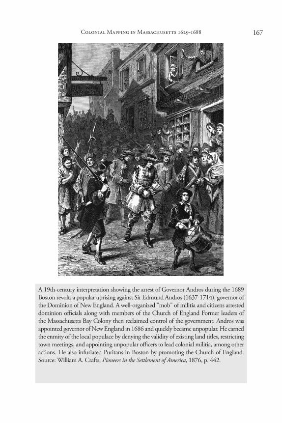
A 19th-century interpretation showing the arrest of Governor Andros during the 1689 Boston revolt, a popular uprising against Sir Edmund Andros (1637-1714), governor of the Dominion of New England. A well-organized "mob" of militia and citizens arrested dominion officials along with members of the Church of England Former leaders of the Massachusetts Bay Colony then reclaimed control of the government. Andros was appointed governor of New England in 1686 and quickly became unpopular. He earned the enmity of the local populace by denying the validity of existing land titles, restricting town meetings, and appointing unpopular officers to lead colonial militia, among other actions. He also infuriated Puritans in Boston by promoting the Church of England. Source: William A. Crafts, Pioneers in the Settlement of America, 1876, p. 442.

Historical Journal of Massachusetts • Winter 2020168
Wells also made several non-survey maps, including one of the entirety of the coast of North America, from Newfoundland to Honduras, and another of Boston Harbor (Fig 4). Most likely ordered by the Board of Trade, the map of Boston Harbor incorporated information from multiple ship captains. The map, while having some stylistic similarities with Wells’s other maps, shows sounding depths throughout the harbor, along with extremely detailed coastal sketches. No land borders are present, and towns are simply represented with the image of a single house.35 This map, although made in the colonies, shows the difference in priorities between those living in the colonies and those outside. Wells had the skill to make larger scale maps, but only did so at the request of outsiders. New Englanders saw the power of cadastral maps as a local tool but had little interest in maps’ usage as an imperial tool.
After the end of the Dominion in 1689 with the overthrow of King James II during England’s Glorious Revolution, Wells left fewer traces. He no longer acted as a surveyor for any government. In 1693, records mentioned Wells in an order for a “surveyor to lay out and map land on the Kill van Kull, late Gov. Lovelace’s petitioned for by Philipp Welles.” Wells next appears in 1697 in a government paper which referred to him as an attorney for Andros in the “Judgement in re Sir Edm. Andros[...]vs Rich’d Pattishall for debt.” In 1700, the land records referred to one of his surveys, and finally in 1712, a description of land on Staten Island, mentioned land owned by Wells on the island.36 From 1690 to 1712, Wells left only faint traces of his surveying and landowning.
It is quite possible that more English maps were made of Massachusetts in 1687 and 1688 than in the one-hundred years since the English discovery of the area. Not only were there now numerous surveyors present, both its growing population and British officials had developed a keen sense of the utility of maps. Even though the Dominion of New England failed shortly after its creation, this technological new approach won out over the traditional surveying methods of the early colonists. Had he lived in the post 1688 society left by Wells, Graves could have thrived instead of fading into obscurity. For Wells, his skill as a surveyor made him invaluable to powerful men, gained him several tracts of land that he would hold for decades, and gave him authority. While both he and Graves were experienced surveyors and mapmakers, fifty years caused significant change in Massachusetts.
In the 1700s, mapmaking and professional surveying in Massachusetts continued to expand. While techniques and approaches remained largely the same, the frequency of surveys and the extent of projects drastically increased. More surveyors who served as imperial officials made their way

169
to New England. For example, between 1699 and 1700, Colonel William Romer surveyed forts and frontier territories in New England to prepare the region for future wars with the French.37 Surveying also became a potent tool in the race to claim land in newly opened frontier territory in Maine and western Massachusetts. As land speculators and settlers planned new towns, they employed surveyors and mapmakers.38 Professional surveying and mapmaking became the dominant ways of describing land.
Colonial Mapping in Massachusetts 1629-1688
Fig 1: Clements’ stylistic embellishments stand in stark contrast with most of New England’s surveyors, including Wells. Most surveyors preferred a strictly functional style, with small writing and no compass. Clements’ bold writing and use of color for water on maps makes him truly stand out.
SC1/series 50. Third Series Maps. v. 33 p. 6. Plan of tract of Nonsuch Point in Falmouth, ME, surveyed for Capt. Sylvanus Davis by Richard Clements, dated November 14, 1687. Massachusetts Archives. Boston, Massachusetts. Courtesy of Massachusetts State Archives.
Historical Journal of Massachusetts • Winter 2020170
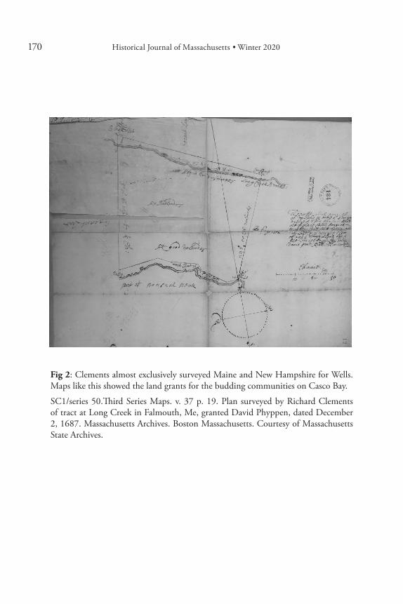
Fig 2: Clements almost exclusively surveyed Maine and New Hampshire for Wells. Maps like this showed the land grants for the budding communities on Casco Bay.
SC1/series 50.Third Series Maps. v. 37 p. 19. Plan surveyed by Richard Clements of tract at Long Creek in Falmouth, Me, granted David Phyppen, dated December 2, 1687. Massachusetts Archives. Boston Massachusetts. Courtesy of Massachusetts State Archives.

171Colonial Mapping in Massachusetts 1629-1688
Fig 3: Although not all of the maps Wells made of New England survived, they show he had a wide range of cartographic ability. This map shows the style he employed for surveys. Wells’ use of a grid was rare for New England surveyors.
SC1/series 50. Third Series Maps. v. 3 p. 3. Two plans of land near Chelsea (Rumney Marsh) granted Lieut. Col. Nicholas Paige and wife, January 18, 1687, made by Philip Welles, dated February 16, 1687. Massachusetts Archives. Boston, Massachusetts. Courtesy of Massachusetts State Archives.

Historical Journal of Massachusetts • Winter 2020172
Fig 4: The embellishments and style employed by this chart show a very different approach then Wells’s minimalist surveying maps.
Phillip Wells, “This harbour of Boston,” Circa 1688, Norman B. Leventhal Map Center, https://collections.leventhalmap.org/search/commonwealth:x633f945h (accessed March 20, 2018). Map reproduction courtesy of the Norman B. Leventhal Map Center at the Boston Public Library.
HJM
173
Notes
1. This project and research has received support from the University of Connecticut History Department and the J.B. Harley Fellowship in the History of Cartography. 2. Max Edelson, The New Map of Empire (Cambridge, MA: Harvard University Press, 2017); J.B. Harley, “Rereading the Maps of the Columbian Encounter,” in Annals of the Association of American Geographers 82, No. 3 (September 1992):522-536; J.B. Harley, The New Nature of Maps: Essays in the History of Cartography (Baltimore: The John Hopkins University Press, 2001); J.B. Harley, “New England Cartography and the Native Americas,” in American Beginnings: Exploration, Culture, and Cartography in the Land of Norumbega, eds. Emerson W. Baker et. al. (Lincoln: University of Nebraska Press, 1994), 287-314; John L. Allen, “The Indrawing Sea: Imagination and Experience in the Search for the Norwest Passage, 1492-1632,” in American Beginnings, 7-35; Matthew H. Edney, “A Cautionary Historiography of John Smith’s New England,” in Cartographica: The International Journal for Geographic Information and Geovisualization 46, No. 1 (Spring 2011): 1-27.
For more on the technological development in the British Empire, see Lesley B. Cormack, Charting an Empire: Geography at the English Universities, 1580-1620 (Chicago: The University of Chicago Press, 1997). For a brief examination of early mapping in New England see Barbara McCorkle, “The Mapping of New England before 1800,” in Mapping Boston, eds. Alex Krieger, David Cobb, and Amy Turner (Boston: The Muriel G. and Norman B. Leventhal Family Foundation, 1999), 22-35. For an incomplete catalog of printed maps from New England in this period see Barbara McCorkle, New England in Early Printed Maps, 1513-1800 (Providence: The John Carter Brown Library, 2001), 3-53. For an examination of indigenous mapping traditions employed in the English colonies see Margaret W. Pearce, “Native Mapping in Southern New England Indian Deeds,” in Cartographic Encounters: Perspectives on Native American Mapmaking and Use, ed. G. Malcolm Lewis (Chicago: Chicago University Press, 1998), 157-171. 3. For some examples see “[Bounds of Connecticut],” May 1684, Colonial Boundaries, Series 1, Vol. 2, Connecticut State Archives, Hartford; Towns & Lands, Series 1, Vol. 1 Before 1695, #113, Connecticut State Archives, Hartford; Mark Griswold, “[Map of New London and Old Saybrook]”, 12 March 1672, Towns and Lands, Series 1, Vol. 1 before 1695, #113c, Connecticut State Archives, Hartford.4. John Winthrop, The Journal of John Winthrop, eds. Richard S. Dunn, James Savage, and Laetitia Yeandle (Cambridge, MA: The Belknap Press of Harvard University Press, 1996), 53, 69, 91-92, 147, 149, 495. 5. “An American Rear Admiral of the Commonwealth Period,” in Colonial Wars 1, No. 1, ed. Walter Kendall Watkins (December, 1913), 261. There are also other Thomas Graves that appear after 1640 in New England, suggesting that as many as four men may have had that name. 6. “England Births and Christenings, 1538-1975,” database, FamilySearch (https://familysearch.org/ark:/61903/1:1:V5LY-NX8 : 11 February 2018, Thomas Graves,
Colonial Mapping in Massachusetts 1629-1688
Historical Journal of Massachusetts • Winter 2020174
12 Jun 1586); citing SAINT PAUL,CANTERBURY,KENT,ENGLAND, index based upon data collected by the Genealogical Society of Utah, Salt Lake City; FHL microfilm 942.23 C1 V26CT.7. The Governor and Deputy of the New-England Company for a Plantation in Massachusetts Bay, “The Company’s First General Letter of Instruction to Endicott and his Council,” in Chronicles of the First Planters of the Colony of Massachusetts Bay, From 1623-1636, ed. Alexander Young (Boston: Charles C. Little and James Brown, 1846), 152-155. One of the most famous examples of a soldier fighting against the Turkish is John Smith.8. John Norden, The Surveyors Dialogue: Very profitable for all men to persue, but especially for al Gentlemen or any other Farmer, or Husbandman… (London:Printed by Thomas Snodham, 1618), 17. For more on surveying literature, see Richard Benese, The Boke of Measuryng Lande: As Well of Woodland as Plowland, & Pasture in the Feelde… (London: Thomas Coldwell, 1565); George Atwell, The Faithfull Surveyor: Discovering Divers Errours in Land Measuring; and Shewing How to Measure All Manner of Ground, and to Plot It, and to Shut it, and to Prove the Shutting, by the Chain Onely…, (Cambridge: Printed for the author, at the charges of Nathanael Rowls, 1658); Peter Barber, “Mapmaking in England,” 1639. For an example of a map that shows evidence of surveyor training or reading in the Winthrop family see Winthrop Family Member, “Tenhills,” October 1637, Winthrop Family Papers, Massachusetts Historical Society, Boston.9. “The Company’s First General Letter,” Chronicles, 152-155; “Records of the Governor and Company of the Massachusetts Bay in New-England,” 5 March 1629 9 March 1629 and 10 March 1629, Chronicles, 53, 54, 56-57. For more on salt in New England, see: Walter W. Woodward, Prospero’s America: John Winthrop, Jr., Alchemy, and the Creation of New England Culture, 1606-1676 (Chapel Hill: Published for the Omohundro Institute by the University of North Carolina Press, 2010), 53-55. 10. “The Company’s First General Letter,” 152, 157. 11. “Records of the Governor and Company,” 5 March 1629, 53-54.12. “Records of the Governor and Company,” 10 March 1629, 57-59; “The Company’s First General Letter,” 152-155.13. “Records of the Governor and Company,” 5 March 1629, 53; “The Company’s First General Letter,” 144. “The Company’s Second General Letter of Instruction to Endicott and his Council,” 28 May 1629, in Chronicles, 191. “The Form of Government for the Colony,” 30 April 1629, in Chronicles, 194. 14. “The Charlestown Records,” in Chronicles, 375-378. 15. These maps were only made by the most educated colonists. For examples see Squaw Sachem, Henry Whitfield, John Higgonson, Robert Newman, Quassaquench, Articles of Agreement, 23 August 1639, Miscellaneous Bound, 1629-1658, Massachusetts Historical Society, Boston; William Bradford, “The meersteads & garden plots of which came first layed out 1620,” circa 1620, in The Records of the

175Colonial Mapping in Massachusetts 1629-1688
Colony of New Plymouth in New England. Deeds, &Cm Eds. Nathaniel B. Shurtleff and David Pulsifer (Boston: WIlliam White, 1861), 1:2.16. Bray Rosseter, “Survey of a plott in Windsor,” 15 May 1640, Private Controversies, Series 1, Vol. 1, #63, Connecticut State Archives, Hartford. 17. For an example see: John Roberts, Samuel Vassal, Benjamen Ruyder, E. Manchester, Miles Corbet, Arthur Harterigge, Robert Warwicke, and Dennis Bond, Addition of Land to Ye Inhabitants of Massachusetts in New Eng.d, 10 December 1643, SP 9/208, #38, U.K. National Archives, Kew. 18. Thomas Leffinwell, Reynold Marvin Thomas Minor, Hugh Caulkin, Robert Hempsted, [Agreement between the town of Pequot and Saybrook over their Bounds], 11 September 1651, Connecticut Colonial Land Records, 1640-1673, Vol. 46, #286b, Connecticut State Archives, Hartford.19. Thomas Graves and Francis Higginson, “Some brief Collections out of a Letter that Mr. Higginson sent to his friends at Leicester,” September 1629, in Chronicles, 264-266.20. In his survey of individual English colonists, historian Robert Anderson argues that this land was owned by the surveyor Graves, as the ship captain Graves only settled in Charlestown in 1639. See Robert Charles Anderson, The Great Migration Begins: Immigrants to New England, 1620-1633 (Boston: New England Historic Genealogical Society, 1995), 1: 806. 21. Proceedings, March 6, 1632, 2 July 1633, 6 August 1633, Records of the Governor and Company of the Massachusetts Bay in New England, 1628-1641, ed. Nathaniel B. Shurtleff (Boston: The press of William White, 1853), 1: 94, 102, 106, 107. “The Charlestown Records,” 378.22. “Charlestown Land Records” in Third Report of the Record commissioners of the City of Boston (Boston: Rockwell and Churchill, City Printers, 1878), 27, 52, 72, 110, 119. 23. “Thomas Graves: 1645 Settler of Hartford, Connecticut and Hatfield, Massachusetts and His Descendants,” Graves Family Association, 12 January 2018, http://www.gravesfa.org/gen168.htm.24. Woodward, 55.25. For an example, see the map Uncas made for Connecticut officials and investors of Pequot Territory, which was used as proof of land claims. Uncas, Casasinamon, Nesahegen, George Denison, John Tinker, [Map of a Portion of Pequot Territory], 4 August 1662, Yale Indian Papers Project, http://findit.library.yale.edu/yipp/catalog/digcoll:3475.26. There was also a Philip Wells christened on 27 February 1658, but this seems too late. “England Births and Christenings, 1538-1975,” database, FamilySearch. 27. John Lewin, The humble Report of John Lewin Gent Agent, in Documents Relative to the Colonial History of the State of New York, ed. John Romeyn Brodhead (Albany: Weed, Parsons and Company, Printers, 1853), 302; Daniel Denton, A Brief Description of New York (Carlisle, MA: Applewood Books, 1845), 159; Calendar of N.Y. Colonial Manuscripts: Indorsed Land Papers; In the Office of the secretary of State

Historical Journal of Massachusetts • Winter 2020176
of New York, 1643-1803 (Albany: Weed, Paterson & Co., 1864), 21, 45. Eventually, Wells became a landowner in New York. On 2 December 1680, Wells surveyed a “a piece of ground situated on the south side of Stoney street, known by the name of the ground of the five houses,” one of which was owned by “Phillip Welles, surveyed by Phillip Welles.” In 1687, records indicated he owned a different plot of land, lying “along the Kill van Kull, being part of the late Gov: Lovelace’s estate.” This plot was surveyed by another New York surveyor, Agustus Graham.28. Calendar of Council Minutes, 1668-1783 (Albany: University of the State of New York, 1903), 45, 49, 50, 61; Denton, 159; Julius Tuttle, ed., “Land Warrants Issued Under Andros, 1687-1688,” in Publications of the Colonial Society of Massachusetts, Vol. 21 (Boston: Colonial Society of Massachusetts, 1920), 294 n.3.29. Calendar of N.Y. Colonial Manuscripts: Indorsed Land Papers, 20-45. The author has done extensive research on maps made between New England settlement and 1700, which will be published in his dissertation. 30. John Smith, “A Plat of the Farms in the Township of Coweset as They Were Laid out by Order of the Proprietors There of the Beginning of the Year 1685,” 1685, Map # 0188, Rhode Island Historical Society. Furthermore, Tuttle found records that described Smith as of “New Bristoll” when he was appointed deputy surveyor. Tuttle also finds that Gore was described of as of Roxbury. Tuttle, 295. 303.31. Gavin Taylor, “Ruled with a Pen: Land, Language, and the Invention of Maine” (PhD diss., The College of William and Mary, 2000), 126-127; Edmund Andros, Warrant to lay out Land for Mr Symon Lyndel at Paucatuck neck, 17 June 1687, in Tuttle, 294; Edmund Andros, Warrant to survey the Land of Narraganset, 22 June 1687, in Tuttle, 294-295; Tuttle, 292, 295-361. 32. Tuttle, 292, 295-361. 33. The majority of the existing Andros era surveying maps are spread across several volumes of SC 50/Series 1, Third Series, Maps and Plans, Massachusetts State Archives. However, several of John Smith’s maps, including at least one from before his time working with Wells are at the Rhode Island Historical Society Map Collection. For an example of a non-extant map made by Wells’ surveyors, see Edmund Andros, Warrant to lay out for Charles Ledgett Esq 150 Acres of Land as an addicion to his farme at Charlestoune, 1 August 1687, in Tuttle, 298-299. 34. Edmund Andros, Warrant to Survey houses & Land in Boston and att Rumley marsh for Lievt Coll. Nich: Page, 18 January 1688, in Tuttle, 319-320; Phillip Wells, [Farms of Nicholas Paige], 1687, SC 50/Series 1, Third Series, Maps and Plans, Vol. 3, #130. 35. Phillip Wells, “[A map of the east coast of America from Newfoundland to the Bay of Honduras],” 1686, Norman B. Leventhal Map Center, https://collections.leventhalmap.org/search/commonwealth:x633f945h (accessed March 20, 2018); Phillip Wells, “This harbour of Boston,” Circa 1688, Norman B. Leventhal Map

177
Center, https://collections.leventhalmap.org/search/commonwealth:x633f945h (accessed 20 March 2018).36. Calendar of Council Minutes, 86, 122; Calendar of N.Y. Colonial Manuscripts: Indorsed Land Papers, 54, 100.37. For some examples see William Romer, “A Map of Casco Bay in America,” 1699, CO 700, Maine 3, The National Archives, Kew, U.K.; William Romer, “Saco Fort in America,” 1699, CO 700, Maine 2; William Romer, “Wood Island in the Mouth of the Piscataqua River in New England,” 1699, CO 700, New Hampshire 2. For more on the continuity of techniques in surveying but the expanded scale, see Stephen J. Hornsby, Surveyors of Empire: Samuel Holland, J.W.F. Des Barres, and the Making of the Atlantic Neptune (Montreal: McGill-Queen’s University Press, 2011), 105-115. For general changes in mapping culture see Martin Brückner, The Geographic Revolution in Early America: Maps, Literacy, and National Identity (Cha-pel Hill: Published for the Omohundro Institute of Early American History and Culture, Williamsburg, Virginia, by the University of North Carolina Press, 2006). 38. See Matthew H. Edney, “Competition Over Land, Competition Over Empire: Public Discourse and Printed Maps of the Kennebec River, 1753-1755,” in Early American Cartographies, ed. Martin Brückner (Chapel Hill: University of North Carolina Press, 2011), 276-305.
Colonial Mapping in Massachusetts 1629-1688