surveyor general’s directions
TRANSCRIPT
Surveyor General’s
Directions
No. 6
Water as a Boundary
Procedures
Surveyor General's Directions
Water as a Boundary – Procedures – June 2016 6-i
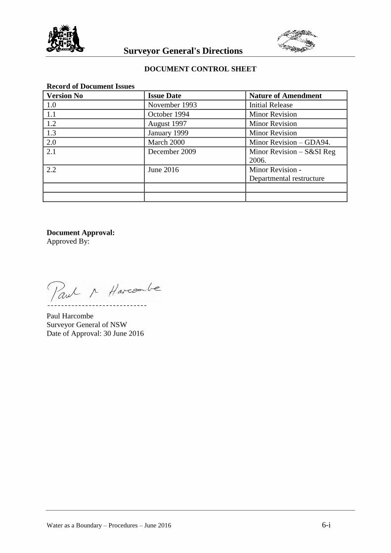
DOCUMENT CONTROL SHEET
Record of Document Issues
Version No Issue Date Nature of Amendment
1.0 November 1993 Initial Release
1.1 October 1994 Minor Revision
1.2 August 1997 Minor Revision
1.3 January 1999 Minor Revision
2.0 March 2000 Minor Revision – GDA94.
2.1 December 2009 Minor Revision – S&SI Reg
2006.
2.2 June 2016 Minor Revision -
Departmental restructure
Document Approval:
Approved By:
Paul Harcombe
Surveyor General of NSW
Date of Approval: 30 June 2016
Surveyor General's Directions
Water as a Boundary – Procedures – June 2016 6-ii
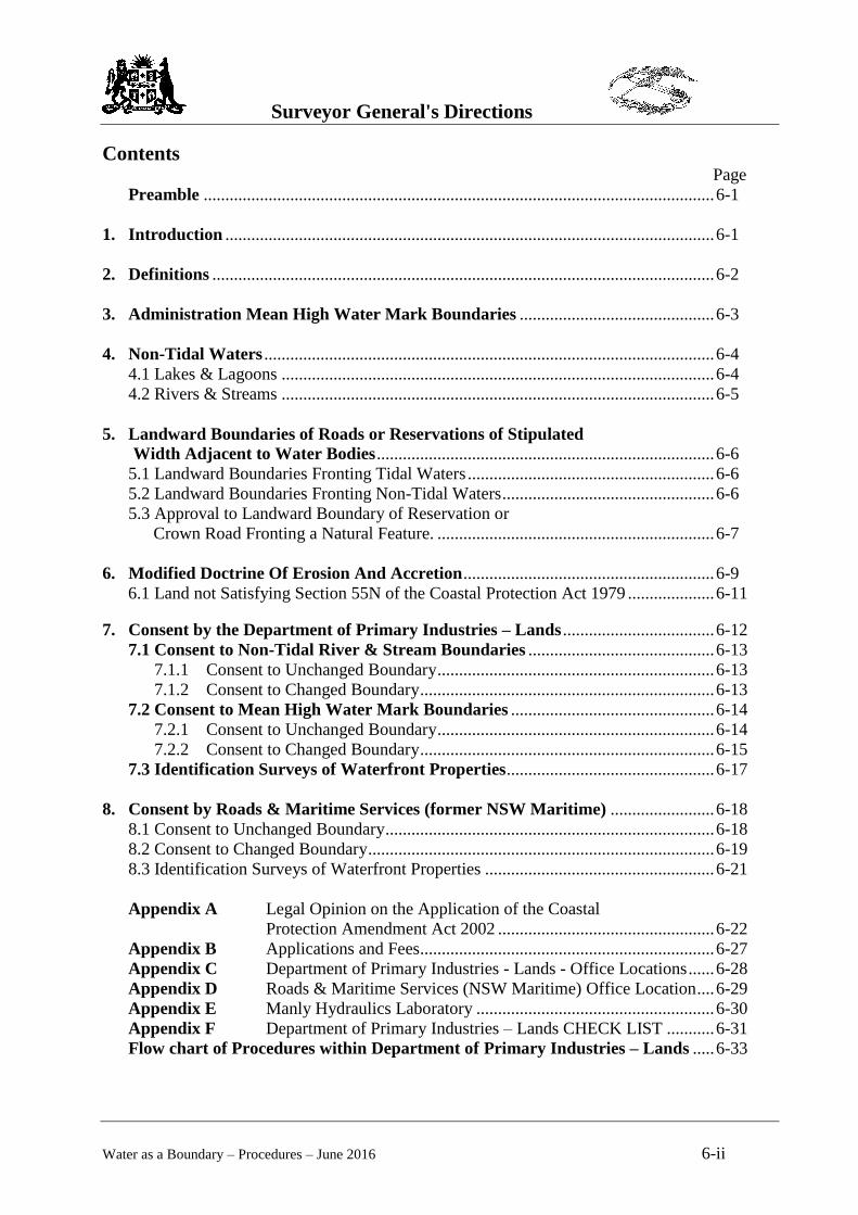
Contents Page
Preamble ...................................................................................................................... 6-1
1. Introduction ................................................................................................................. 6-1
2. Definitions .................................................................................................................... 6-2
3. Administration Mean High Water Mark Boundaries ............................................. 6-3
4. Non-Tidal Waters ........................................................................................................ 6-4
4.1 Lakes & Lagoons .................................................................................................... 6-4
4.2 Rivers & Streams .................................................................................................... 6-5
5. Landward Boundaries of Roads or Reservations of Stipulated
Width Adjacent to Water Bodies .............................................................................. 6-6
5.1 Landward Boundaries Fronting Tidal Waters ......................................................... 6-6
5.2 Landward Boundaries Fronting Non-Tidal Waters ................................................. 6-6
5.3 Approval to Landward Boundary of Reservation or
Crown Road Fronting a Natural Feature. ................................................................ 6-7
6. Modified Doctrine Of Erosion And Accretion .......................................................... 6-9
6.1 Land not Satisfying Section 55N of the Coastal Protection Act 1979 .................... 6-11
7. Consent by the Department of Primary Industries – Lands ................................... 6-12
7.1 Consent to Non-Tidal River & Stream Boundaries ........................................... 6-13
7.1.1 Consent to Unchanged Boundary ................................................................ 6-13
7.1.2 Consent to Changed Boundary .................................................................... 6-13
7.2 Consent to Mean High Water Mark Boundaries ............................................... 6-14
7.2.1 Consent to Unchanged Boundary ................................................................ 6-14
7.2.2 Consent to Changed Boundary .................................................................... 6-15
7.3 Identification Surveys of Waterfront Properties ................................................ 6-17
8. Consent by Roads & Maritime Services (former NSW Maritime) ........................ 6-18
8.1 Consent to Unchanged Boundary ............................................................................ 6-18
8.2 Consent to Changed Boundary ................................................................................ 6-19
8.3 Identification Surveys of Waterfront Properties ..................................................... 6-21
Appendix A Legal Opinion on the Application of the Coastal
Protection Amendment Act 2002 .................................................. 6-22
Appendix B Applications and Fees.................................................................... 6-27
Appendix C Department of Primary Industries - Lands - Office Locations ...... 6-28
Appendix D Roads & Maritime Services (NSW Maritime) Office Location .... 6-29
Appendix E Manly Hydraulics Laboratory ....................................................... 6-30
Appendix F Department of Primary Industries – Lands CHECK LIST ........... 6-31
Flow chart of Procedures within Department of Primary Industries – Lands ..... 6-33
Surveyor General's Directions
Water as a Boundary – Procedures – June 2016 6-1
Preamble
This Surveyor General’s Direction replaces the previous Direction issued in
January 1999. It includes new procedures to obtain approval to determinations of
water boundaries, including tidal or Mean High Water Mark (MHWM) and non-
tidal boundaries. There have been many changes to MHWM procedures due to
recent government departmental restructuring and amendments of the Coastal
Protection Act 1979, which established the “Modified Doctrine of Accretion”.
In summary, changes included within this Direction are:
New procedures to address the Modified Doctrine of Accretion as defined in
the Coastal Protection Act 1979 (Section 55N);
New departmental procedures; and
New surveying requirements under the Surveying and Spatial Information Act
2002.
A consequence of the Modified Doctrine of Accretion is that a MHWM
application may now be required to meet specific criteria prior to approval. In
particular, where a definition that increases the area of land to the landward side of
the water boundary because of accretion, the applicant will now have to
demonstrate that the area, the subject of the accretion claim will:
a) have a perceived trend of accretion that is likely to be indefinitely sustained
by natural means; and
b) as a consequence of making the claim, not likely restrict or deny public access
to a beach, headland or waterway.
The approval procedure for boundaries of Crown Land (i.e. Crown Land as
defined under the Crown Lands Act 1989) has been revised to accord with the
amendments to Part 7 of the Surveying and Spatial Information Regulation and
the formation of the Department of Lands. See section 7.
Where new determinations of MHWM adjoin land managed by Roads & Maritime
Services (such as Sydney Harbour), then approval from Roads & Maritime
Services is required. See section 8.
1. Introduction
This Surveyor General’s Direction outlines the procedures for:
1. Determining mean high water mark as a boundary, or
2. Determining the bank or banks of non-tidal streams, or
3. Determining the location of the landward boundary of roads or reservations of
stipulated width adjacent MHWM or non-tidal streams which have not
previously been surveyed, or
4. Situations where there is doubt or confusion as to the location of natural
feature boundaries.
Surveyor General's Directions
Water as a Boundary – Procedures – June 2016 6-2
Except under special conditions, as prescribed by law, a boundary cannot extend
below mean high water mark. Where the bank or MHWM has eroded suddenly
and the processes causing the change did not satisfy the doctrine (i.e. natural,
gradual and imperceptible erosion), then the former position of the natural feature
boundary will not change. In these cases the natural feature boundary may extend
into the water. Some methods of determination of mean high water mark are
contained in part 6, section 22 of the Manual of the New South Wales Integrated
Survey Grid (1976). Current tidal plane statistical data should be obtained from
NSW Public Works’ Manly Hydraulics Laboratory.
2. Definitions
“Mean High Water Mark” – see Clause 5 of the Surveying and Spatial
Information Regulation 2012.
The definition of features associated with lakes and rivers are defined in section
172(1) of the Crown Lands Act 1989 or the Surveying and Spatial Information
Regulation 2012. The following terms are defined:
"bank" means the limit of the bed of a lake or river.
"bed" means the whole of the soil of a lake or river including that portion -
(a) which is alternately covered and left bare with an increase or diminution in
the supply of water; and
(b) which is adequate to contain the lake or river at its average or mean stage
without reference to extraordinary freshets in time of flood or to extreme
drought;
"lake" includes a permanent or temporary lagoon or similar collection of water not
contained in an artificial work;
"river" includes any stream of water, whether perennial or intermittent, flowing in
a natural channel, and any affluent, confluent, branch or other stream into or from
which the river flows.
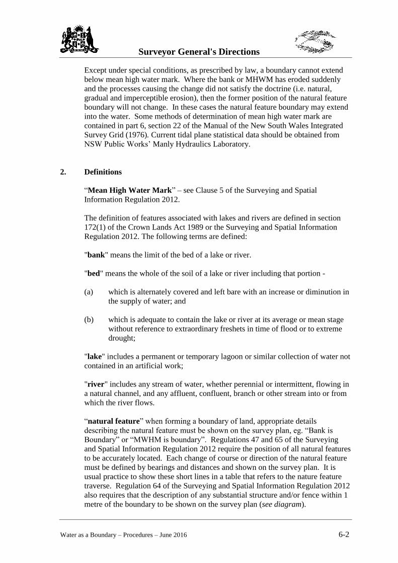
“natural feature” when forming a boundary of land, appropriate details
describing the natural feature must be shown on the survey plan, eg. “Bank is
Boundary” or “MWHM is boundary”. Regulations 47 and 65 of the Surveying
and Spatial Information Regulation 2012 require the position of all natural features
to be accurately located. Each change of course or direction of the natural feature
must be defined by bearings and distances and shown on the survey plan. It is
usual practice to show these short lines in a table that refers to the nature feature
traverse. Regulation 64 of the Surveying and Spatial Information Regulation 2012
also requires that the description of any substantial structure and/or fence within 1
metre of the boundary to be shown on the survey plan (see diagram).

Surveyor General's Directions
Water as a Boundary – Procedures – June 2016 6-3
Short Lines representing the natural feature (i.e. Bank).
Must have statement describing the natural feature
Similar surveying requirements apply to non-tidal and MHWM
boundaries.
3. Administration of Mean High Water Mark Boundaries
Titles to the beds of all tidal waters, unless specifically vested in another authority
or the subject of a Crown Grant, are under common law deemed to be vested in
the Crown (see Hallman 13.39). The Minister administering the Crown Lands Act
1989 (or his delegate) is responsible for the management of these lands and is the
approval authority for Mean High Water Mark re-determination.
Roads & Maritime Services is responsible for administering all land below Mean
High Water Mark in Sydney Harbour, Botany Bay, Port Hunter and Port Kembla
Harbour.
This direction will deal with the responsibility of Roads & Maritime Services
separately. Each organisation has different procedures for approving Mean High
Water Mark definitions.
1 2 3 4 5
6
7
8
13
10 11
12
16 15
14
9
18
17
180 2
3’ 3
0”
528.3
65
A = 2.4ha
Don’t show creek
traverse or radiations.
Show short lines 1 –
18 in a table.
The area is computed
directly from the
closure of the Lot
using the short line
table.
Bank is
Boundary
Surveyor General's Directions
Water as a Boundary – Procedures – June 2016 6-4
4. Non-Tidal Waters
4.1 Lakes and Lagoons
Where a survey plan includes a boundary along a non-tidal lake or lagoon, the
surveyor will be required to adopt the original position of the bank at the time of
alienation. The following summary of section 172 of the Crown Lands Act 1989
applies to non-tidal lakes and lagoons.
Section 172(2) states that the boundary of any land which is alienated by the
Crown and which is described as being bounded by the margin or bank of a non-
tidal lake shall be taken to be the bank of the lake at the time of the Crown survey
for the purpose of alienation.
Section 172(3) states that if the title of alienated land is described as being
bounded by a non-tidal lake, then that title does not and never has extended to
include any part of the bed of the lake. No person who is the owner of adjoining
land so alienated is entitled to any rights of access over, or to the use of any part of
the bed.
Section 172(4) states "The doctrine of accretion does not apply, and never has
applied, to a non-tidal lake".
To assist surveyors prepare applications for redefinition, the following water
bodies have been judged to be non-tidal:
Narrabeen Lagoon (Attorney General (NSW) v Wheeler (1944) 45 SR (NSW)
321)
Dee Why (Williams v Booth (1910) 10 CLR 341)
Glenrock Lagoon (Attorney General (NSW) v Merewether (1905) 5 SR
(NSW) 157)
Lake Illawarra (Attorney General v Swan (1921) 21 SR (NSW) 408)
Therefore, the doctrine of accretion and erosion does not apply to land adjoining
those water bodies. There may be other non-tidal water bodies within New South
Wales that by virtue of their character may be deemed non-tidal.
In any case where the original position of the bank cannot be reproduced with
certainty, the approval of the Minister administering the Crown Lands Act 1989 or
his delegate to a proposed definition of the bank is required. The procedure to
obtain this consent is similar to that for a determination of mean high water mark.
In any case where the bank of a non-tidal lake or lagoon is be to used as a natural
feature boundary to define a new land grant or title, then the bank shall be the limit
of the bed as described in the Crown Lands Act 1989. No new boundary of a lot
shall be an ill-defined natural feature (e.g. cliffs, lakes, and swamps). In those
situations, the boundary must be defined and marked by a series of straight lines
Surveyor General's Directions
Water as a Boundary – Procedures – June 2016 6-5
that do not represent or approximate the ill-defined natural feature. The ill-
defined natural feature will not be the boundary.
4.2 Rivers and Streams
Rivers and streams are subject to the doctrine of accretion and erosion. Where a
survey includes a boundary along a non-tidal river or stream, the surveyor will
adopt the presently existing bank or centre line, ONLY
i) if it agrees with the original position, or
ii) if it can be proven that the change from the original position to the
present position has been caused by natural, gradual and
imperceptible means. In most Australian riverine situations this
occurrence will be rare and must be substantiated with evidence
and facts to support the case, or
iii) if it can be proven that the previous definition of the bank was
incorrect. In most cases this will be very difficult to prove.
If the position of the bank has changed suddenly, or by artificial means (i.e. flood,
reclamation etc.), then the definition of the bank before the sudden change or
changes occurred must be adopted.
The existing position of the bank in addition to the original position of the bank
must also be shown on the survey plan with appropriate details noted as to what
constitutes the boundary.
The Surveying and Spatial Information Regulation 2012 states:
47(3) If (a) the middle line of a stream is the boundary of land and has not
previously been defined by survey, or (b) the middle line of a stream is
otherwise required to be determined, both banks of the stream must be
surveyed and shown on the survey plan together with the determination of
the middle line.
47(4) The middle line of a stream need not be marked unless the purpose
for which the survey is made so requires.
Therefore, if a title extends to the centre of the stream, then the surveyor must
determine the position of both banks as the means of defining the centre line of the
bed. All three features are to be noted on the survey plan with the appropriate
details as to what constitutes the boundary.
Surveyor General's Directions
Water as a Boundary – Procedures – June 2016 6-6
5. Landward Boundaries of Roads or Reservations of Stipulated Width
Adjacent to Water Bodies
The surveyor must obtain the approval of the Minister administering the Crown
Lands Act 1989 when the survey abuts the landward boundary of any road or
reservation fronting a river, stream or tidal waters and that landward boundary has
not previously been defined by survey, (see Division 5 “Boundaries formed by
tidal and non-tidal waters and other natural features” of the Surveying and Spatial
Information Regulation 2012).
The Surveying and Spatial Information Regulation requires the traverse lines of
the survey to be positioned so that each change of course or direction of the
boundary can be determined. It also requires the natural feature to be described by
bearings and distances with appropriate details describing the natural feature be
shown on the survey plan.
5.1 Landward Boundaries of Reservation Fronting Tidal Waters
Regulation 45(1) of the Surveying and Spatial Information Regulation 2012 states
“In any survey for the redefinition or subdivision of land adjoining an existing
Crown reserve of stipulated width fronting tidal waters where the boundary
between the land being surveyed and the Crown reserve has not previously been
defined by survey, the boundary must be defined by straight lines approximately
parallel to the position of the mean high-water mark as originally defined.”
The landward boundary of the reserve fronting tidal waters must be marked in
accordance with Regulations 28, 29 and 30 and Schedules 2 and 3 of the
Surveying and Spatial Information Regulation 2012.
The position of the existing MHWM must be shown by a series of short lines
positioned so that each change of course or direction of the present natural feature
can be determined. Appropriate details describing the natural feature must be
shown on the survey plan.
If a surveyor determines the landward boundary of a reservation or road that has
not been previously approved, then Regulation 45(3) of the Surveying and Spatial
Information Regulation 2012 requires the approval of the Minister administering
the Crown Lands Act 1989 to the landward boundary. See Section 5.3 for details.
5.2 Landward Boundaries of Reservation or Crown Road of Stipulated
Width Fronting Non-Tidal Waters
Regulation 45(2) of the Surveying and Spatial Information Regulation states; ‘In
any survey for the redefinition or subdivision of land adjoining an existing Crown
reserve or Crown road of stipulated width fronting a lake, stream or natural
Surveyor General's Directions
Water as a Boundary – Procedures – June 2016 6-7
feature where the boundary between the land being surveyed and the Crown
reserve or Crown road has not previously been defined by survey:
(a) the boundary must be defined by straight lines approximately parallel
to the position of the bank of the lake or stream, or of the natural feature,
as originally defined, and
(b) the position of the bank or natural feature, as originally defined, must
be shown on the survey plan, and
(c) the position of any existing road formation or fencing must be shown on
the survey plan, and
(d) the boundary need not be marked in accordance with clause 28 but, if it
is not marked in accordance with that clause, a reference mark must be
placed at the terminals of the boundary and at intervals of not more than
1,000 metres along the boundary.
Therefore, the normal marking of each corner or angle of the landward boundary
is not required.
The position of the existing bank must be shown by a series of short lines
positioned so that each change of course or direction of the present natural feature
can be determined. Appropriate details describing the natural feature must be
shown on the survey plan.
In addition, the position of the legal or original bank must be shown by a series of
lines positioned so that each change of course or direction of the boundary can be
determined. Appropriate details describing the boundary must be shown on the
survey plan.
If a surveyor determines the landward boundary of a reservation or road that has
not been previously approved, then Clause 45(3) of the Surveying and Spatial
Information Regulation 2012 requires the approval of the Minister administering
the Crown Lands Act 1989 to the landward boundary.
Note: Where the landward boundary of a road is involved, applicants should be
aware that procedures under Section 18 – 21 of the Roads Act 1993 may apply.
5.3 Approval to Landward Boundary of Reservation or Crown Road
Fronting a Natural Feature
To obtain the consent of the Minister administering the Crown Lands Act 1989,
the application should be forwarded in the first instance to the Department of
Primary Industries – Lands, at the address shown in Appendix B.
The consent from District Offices of the Department of Primary Industries – Lands
Surveyor General's Directions
Water as a Boundary – Procedures – June 2016 6-8
is not required when no Crown land is involved.
Approval to the new definition of the landward boundary of the reservation or
crown road fronting a natural feature should be sought prior to lodgement of the
survey plan at Titling & Registry Services – Department of Finance, Services &
Innovation, Queens Square, Sydney. It is recommended that surveyors carrying
out the new definition liaise with officers of the Department of Primary Industries
– Lands (see Appendices B and C) prior to lodgement of the plan, particularly
where there is a marked variation or any other unusual circumstances. A
consultation fee as outlined in Appendix B may apply
When making the submission, the surveyor must lodge an application for a
Landward Boundary approval at the Department of Primary Industries – Lands
(Crown Lands Service, Newcastle) and include the following items:
(a) Three copies of a survey plan signed and dated by a registered surveyor;
clearly defining both the position of the former or current Mean High
Water Mark or stream bank title boundary and the proposed new position
of the natural feature; and
(b) In accordance with the Surveying and Spatial Information Regulation, a
comprehensive report on the definition of the Mean High Water Mark or
bank. The report must:
Provide the basis and method of determining the location of the Mean
High Water Mark or bank and the location of the landward boundary.
The Mean High Water Mark should be referenced to the Australian
Height Datum (AHD) and accord with relevant tidal plane statistical
data (where available) which can be obtained from NSW Public Works’
Manly Hydraulics Laboratory (see Appendix E for contact details). If
AHD is used as the basis of the definition or to support any part of the
justification for the definition, then the datum must be based upon and
verified by a closed level traverse between Permanent Marks that have
accurate heights (i.e. Accuracy Class “LD” or “B” or better).
Provide photographs of the area, particularly when there are
improvements near the foreshore or landward boundary of the reserve
or road.
Provide a report on any improvements adjoining the landward boundary
of the reserve or road.
Provide a full copy of all survey plans used to define the MHWM or
bank and all adjoining survey plans. (These plans will be returned to
the applicant upon request after the completion of the Department’s
investigation).
(c) Provide a completed checklist; and
Surveyor General's Directions
Water as a Boundary – Procedures – June 2016 6-9
(d) A fee for the investigation of the definition (see Appendix B).
A Department of Primary Industries – Lands file will be created for each
application.
Surveyors of the Department of Primary Industries – Lands in each region will
analyse the method and basis of the determination, conduct a site investigation
where appropriate and may consider responses from any other authority.
The applicant will be advised in writing whether their application has been
approved or the basis upon which the application was refused. If approved, one (1)
endorsed copy of the plan will be returned to the applicant. The surveyor must
retain the endorsed copy.
Subsequent amendments to the plan will require two further copies of the plan to
be submitted for approval.
Before registration of the final survey plan at Titling & Registry Services,
Queens Square, Sydney, the following statement will be inserted in the "Signature
and Seals Only" panel of the plan form:
“The Minister for Lands and Water in accordance with Division 5
of the Surveying & Spatial Information Regulation 2012 approves
the determination of the landward boundary of …………… as
shown hereon.
Department of Primary Industries – Lands file ……………... on
…../…../……”
The inclusion of this statement will inform subsequent users of the plan that the
position of the landward boundary of the reserve or reservation had the approval of
the Department of Primary Industries – Lands.
6. Modified Doctrine of Erosion And Accretion
On 7 February 2003, amendments to the Coastal Protection Act 1979 came into
effect modifying the doctrine of erosion and accretion. Section 55N of this Act
modifies the doctrine of erosion and accretion with respect to land:
i). which is within the coastal zone, or which adjoins the tidal waters of Sydney
Harbour or Botany Bay, or their tributaries, and
ii). a boundary ("the water boundary") of which is defined or otherwise
determined by reference to a mean high water mark.
Maps outlining the Coastal Zone are available for inspection during normal office
hours at the principal office of the relevant local government authority or at each
of the relevant regional offices of the Department of Infrastructure, Planning and
Surveyor General's Directions
Water as a Boundary – Procedures – June 2016 6-10
Natural Resources.
Section 55N does not apply to the amendment of titles that were previously
based upon poor, erroneous or inaccurate surveys. See Appendix A for a
complete background to this opinion.
Under Section 55N of the Coastal Protection Act 1979, the doctrine of accretion
has been modified to include additional provisions whereby an accretion claim
cannot be granted if:
(a) a perceived trend by way of accretion is not likely to be indefinitely
sustained by natural means, or
(b) as a consequence of making such a grant, public access to a beach,
headland or waterway will, or is likely to be, restricted or denied.
These legislative changes have been brought about to provide a more sustainable
assessment methodology aimed at preventing the undue loss or inadvertent further
alienation of public foreshore lands. In addition to the existing requirement that
accretion is caused by natural, gradual and imperceptible means, the modified
doctrine of accretion requires that a more rigorous understanding of the physical
shoreline processes will form the basis of the determination.
Firstly, in order for an applicant to demonstrate that “a perceived trend by way of
accretion is likely to be indefinitely sustained by natural means”, it will be
necessary to obtain the professional opinion of practitioners with a demonstrated
level of professional experience in the interpretation and quantification of
hydrodynamic processes and shoreline movements. In particular, professional
assessments would need to be based upon a detailed understanding and assessment
of observations (where available) regarding relevant coastal or estuarine
hydrodynamics, shoreline positions and sediment transport processes. More
specifically, professional assessments would need to cover the following:
History of the subject accretion and determination of quantifiable trends.
It is essential that accurate, quantifiable measures of accretion are readily
substantiated by data analysis. In this respect, photogrammetric analysis of
vertical aerial photography is likely to provide the most accurate data upon
which to conclude trends in the movement of the shoreline and associated
features including the MHWM.
Physical processes impacting upon and governing the stretch of foreshore in
question.
An understanding of the physical processes is essential to demonstrate that
any perceived trend of accretion is likely to be indefinitely sustained by
natural means.
Surveyor General's Directions
Water as a Boundary – Procedures – June 2016 6-11
Implication of climate change (in particular, postulated rise in Mean Sea
Level).
The weight of scientific evidence available predicts accelerated Sea Level
Rise (SLR) over the course of this century. The extent of SLR is not definitive
and predictions rely on a range of global atmospheric models driven by
various greenhouse gas emission scenarios.
The Intergovernmental Panel on Climate Change (IPCC), which was jointly
established by the World Meteorological Organisation and the United Nations
Environment Program in 1988, remains the most authoritative source on
global climate change predictions. The 2001 publication by the IPCC
indicated a broad range of possible predictions of SLR over the period from
1990 to 2100 ranging from a low of 9 centimetres to a high of 88 centimetres.
The average of all these possible scenarios indicates a rise in MSL of
approximately 50 centimetres over this timeframe.
In effect, the result of an increase in MSL is that the active nearshore profile
(and by consequence, ambulatory boundaries such as those defined by
reference to the MHWM), will readjust to a higher and more landward
position over time.
In order to consider the impact of SLR, it will be necessary to assess what
impact a rise in MSL of 50 centimetres would have on the position of the
MHWM. This assessment will provide a fundamental guide to establishing
whether or not any trend of accretion that is evident will likely be
“indefinitely sustainable by natural means” over the longer term, in a position
seaward of the existing ambulatory boundary.
Secondly, in order to meet the provisions of the modified doctrine of accretion, an
applicant must also demonstrate that to grant such a claim would not result in
“public access to a beach, headland or waterway either being, or likely to be,
restricted or denied”. In this respect it would be necessary for the applicant to
provide details of the site in question and document the extent of associated
customary public access. The professional assessment indicated in the afore-
mentioned, will also have to consider the impact of climate change at the site in
respect of denying or restricting public access.
The Local Council will be referenced by the relevant approval authority to provide
information regarding public access issues.
6.1 “Land not Satisfying Section 55N of the Coastal Protection Act 1979”.
If there has been accretion to the foreshore and that accretion cannot satisfy the
conditions of the Modified Doctrine of Accretion, then the original MHWM must
be adopted. New Deposited Plans should show the current title limit (i.e. the
original Mean High Water Mark - described by a series of short lines). The
Surveyor General's Directions
Water as a Boundary – Procedures – June 2016 6-12
present shoreline should also be shown on the Deposited Plan (also, described by
a series of short lines). The present shoreline is the intersection line of the MHW
tidal plane with the adjoining land along the foreshore.
The present shoreline must not be described as a variation of MHWM. Legally
MHWM is the term to describe the title limit, that being the natural feature, which
is the mean of all the high tides including the spring and neap high tides taken over
a sufficiently long period.
The accreted land must be clearly described in the survey plan with the following
notation;
“Land not satisfying Section 55N of the
Coastal Protection Act 1979”.
7. Department of Primary Industries – Lands
Consent Requirements for New Water Boundary Definitions (Including Non-
Tidal and Mean High Water Mark Definitions)
This section applies only where the bed of the water body is Crown Land as
defined under the Crown Lands Act 1989. If another authority owns the bed, then
approval from that authority must be obtained. The submission for their approval
will be similar to the requirements of this section.
There are two categories for obtaining the consent from the Department of
Primary Industries – Lands to new natural feature boundaries - one for non-tidal
river & stream bank boundaries and the other for Mean High Water Mark
boundaries. To obtain the consent of the Minister administering the Crown Lands
Act 1989, the application should be forwarded in the first instance to the
Department of Primary Industries – Lands, at the address shown in Appendix B.
The consent from District Offices of the Department of Primary Industries – Lands
is not required when no crown land is involved.
3.5
1 2
Original
MHWM
Present
Shoreline

Surveyor General's Directions
Water as a Boundary – Procedures – June 2016 6-13
7.1 Consent to Non-Tidal River & Stream Boundaries
7.1.1 Consent to Unchanged Bank Boundaries
The surveyor may dispense with the need for a specific approval of the
Department of Primary Industries – Lands in cases where the plan, when
lodged at Titling & Registry Services, bears a certification. That certification
must state that the position of bank on the ground, as depicted on the plan, is
substantially the same as that shown on a previous plan that had an approval to
the bank definition.
The certification should be in the following terms:
"The location of the existing bank boundary as shown hereon is
substantially the same as that shown on plan ..."
A surveyors’ report must accompany the survey plan. That report must describe
the basis and method of determining the location of the bank, photographs and a
detailed plot of the bank shown in the previous plan and the present bank. The
report must support the certification shown on the survey plan. Titling &
Registry Services on the basis of the certification may accept the definition of the
bank. However, if normal investigations of the plan find the certification to be
inconsistent with the facts, a requisition will be raised.
In the event that consent was not obtained to the previous plan, an approval for the
determination of the bank must be obtained. See Section 7.1.2 for the approval
process.
7.1.2 Consent to Changed Bank Boundaries or Bank Boundaries that do
Not Have a Current Consent
Where a survey reveals a substantial variation in the position of the bank to that
determined by an earlier survey or the position of the bank does not have a current
consent, the approval of the Minister administering the Crown Lands Act 1989 is
required. Usually this is achieved by the surveyor submitting a comprehensive
report with the survey plan at lodgement to the Surveyor General at Spatial
Services – Department of Finance, Services & Innovation, Queens Square,
Sydney.
If the natural feature has not changed and the variation is due to a poor, erroneous
or inaccurate survey of the original bank, then the facts must be disclosed in the
comprehensive report. The report must accompany the survey plan and include
the following:
Describe the basis and method of determining the location of the bank, and
Photographs and evidence relevant to the location of the bank, and
A detailed plot of the bank shown in the previous plan and the present bank,
and
Provide the location and details of any improvements adjoining the bank, and
Surveyor General's Directions
Water as a Boundary – Procedures – June 2016 6-14
A completed checklist.
In complex or difficult bank redefinition situations, the application will be
forwarded to the Department of Primary Industries – Lands for field inspection
and assessment of the facts.
7.2 Mean High Water Mark Boundaries
7.2.1 Consent to Unchanged Boundary
The need for a specific approval of the Department of Primary Industries –
Lands may be dispensed with in cases where the plan, when lodged at Titling &
Registry Services bears a certification by the surveyor. That certification must
state that the position of Mean High Water Mark on the ground, as depicted on the
plan, is substantially the same as that shown on a previous plan that had an
approval to the MHWM definition.
Titling & Registry Services will field audit a sample of survey plans that claim
MHWM to be substantially the same as a previous definition.
The certification should be in the following terms:
"The location of the existing Mean High Water Mark boundary as
shown hereon is substantially the same as that shown on plan ..."
The definition of Mean High Water Mark may be accepted by Titling & Registry
Services on the basis of the certification. However, if normal investigations of the
plan find the certification to be inconsistent with the facts, a requisition will be
raised.
In the event that consent was not obtained to the previous plan, an approval for the
determination of Mean High Water Mark must be sought from the Minister
administering the Crown Lands Act 1989.
An administration fee plus GST will be charged to the surveyor.
When approved, one (1) endorsed copy of the plan will be returned to the surveyor
as a record of the Crown Lands’ consent. That endorsed plan must be submitted
with the final survey plan to Titling & Registry Services.
Before lodging the plan at the Titling & Registry Services, the following
statement should be inserted in the “Signature and Seals Only” panel of the plan
form:
“The Minister for Lands & Water, in accordance with Division 5 of the
Surveying and Spatial Information Regulation 2012 approves the
determination of the MHWM, as shown hereon.
Dept of Primary Industries – Lands file _ _ _ _ on_ _ /_ _/_ _.”
Surveyor General's Directions
Water as a Boundary – Procedures – June 2016 6-15
The inclusion of this statement will inform subsequent users of the plan that the
position of the MHWM had the approval of the Department of Primary Industries
– Lands.
7.2.2 Consent to Changed Boundary
Where a survey reveals a substantial variation in the position of Mean High Water
Mark to that determined by an earlier survey, the approval of the Minister
administering the Crown Lands Act 1989 is required. The cause of the variation is
critical.
Should the cause of the variation be erosion, then there are no further requirements
of the applicant apart from those under the Surveying and Spatial Information
Regulation 2012. The location of the present shoreline and former MHWM must
be described on the survey plan by a series of short lines. The present shoreline is
the intersection line of the MHW tidal plane with the adjoining land along the
foreshore.
However, if the cause of the variation is by accretion to the land and within the
Coastal Zone or Sydney Harbour or Botany Bay and their tributaries, then the
provisions of Section 55N of the Coastal Protection Act 1979 “Modified Doctrine
of Accretion” apply. See Section 6 “Modified Doctrine of Erosion and Accretion”
of this Direction. If the natural feature has not changed and the variation is due to
a poor, erroneous or inaccurate survey of the original MHWM feature, then the
approval of the Minister administering the Crown Lands Act 1989 is still required,
but without the need to prove the Modified Doctrine.
Approval to the new definition of Mean High Water Mark should be sought prior
to lodgement of the survey plan at Titling & Registry Services, Queens Square,
Sydney. It is recommended that surveyors carrying out Mean High Water Mark
definitions, liaise with officers of the Department of Primary Industries – Lands
(see Appendices B and C) prior to lodgement of the plan, particularly where there
is a marked variation or other unusual circumstances. A consultation fee as
outlined in Appendix B may apply.
When making the submission, the surveyor must lodge an application for MHWM
approval at the Department of Primary Industries – Lands and include the
following items:
(a) Three copies of a survey plan signed and dated by a registered surveyor;
clearly defining both the position of the former or current title Mean High
Water Mark boundary position and the proposed new position of this
boundary feature; and
(b) In accordance with the Surveying and Spatial Information Regulation, a
comprehensive report on the definition of Mean High Water Mark. The
report must:
Surveyor General's Directions
Water as a Boundary – Procedures – June 2016 6-16
Provide the basis and method of determining the location of the Mean
High Water Mark. (The Mean High Water Mark should be referenced
to the Australian Height Datum (AHD) and accord with relevant tidal
plane statistical data (where available) which can be obtained from
NSW Public Works’ Manly Hydraulics Laboratory (see Appendix E for
contact details). If AHD is used as the basis of the definition or to
support any part of the justification for the definition, then the datum
must be based upon and verified by a closed level traverse between
Permanent Marks that have accurate heights (i.e. Accuracy Class “LD”
or “B” or better).
If applicable, satisfy the requirements of the Modified Doctrine of
Accretion under the Coastal Protection Act 1979 in accordance with the
procedures outlined in Section 6.
Provide photographs of the area, particularly when there are
improvements near the foreshore.
Provide a report on any improvements adjoining the foreshore.
Provide a full copy of all survey plans used to define the MHWM and
all adjoining survey plans. (These plans will be returned to the
applicant upon request after the completion of the Department’s
investigation).
(c) Provide a completed checklist; and
(d) A fee for the investigation of the definition (see Appendix B).
A Department of Primary Industries – Lands file will be created for each
application.
Surveyors of the Department of Primary Industries – Lands in each region will
analyse the method and basis of the determination, conduct a site investigation
where appropriate and may consider responses from any other authority.
The applicant will be advised in writing whether their application has been
approved or the basis upon which the application was refused. If approved, one (1)
endorsed copy of the plan will be returned to the applicant. The surveyor must
retain the endorsed copy.
Subsequent amendments to the plan will require two further copies of the plan to
be submitted for approval.
Before registration of the final survey plan at Titling & Registry Services,
Queens Square, Sydney, the following statement will be inserted in the "Signature
and Seals Only" panel of the plan form:
Surveyor General's Directions
Water as a Boundary – Procedures – June 2016 6-17
“The Minister for Lands and Water, in accordance with Division 5
of the Surveying and Spatial Information Regulation 2012,
approves the determination of the MHWM Boundary of lots …….,
as shown hereon.
Dept of Primary Industries – Lands file ______ on __/__/__.
If the variation was caused by accretion to the adjoining land, then the “Modified
Doctrine” must be satisfied. In that case relevant documents will be forwarded to
the local council and the Office of Environment & Heritage to comment on the
applicant’s submission in regard to the issues of public access and indefinite
sustainability (see Section 6).
If the application satisfies all criteria of the Modified Doctrine then the following
statement will be inserted in the "Signature and Seals Only" panel of the plan
form:
“The Minister for Lands and Water in accordance with Division 5
of the Surveying and Spatial Information Regulation 2012 and
Section 55N of the Coastal Protection Act 1979 as amended,
approves the determination of the MHWM Boundary of lots …… ,
as shown hereon.
Dept of Primary Industries – Lands file ______ on __/__/__.
The inclusion of these statements will inform subsequent users of the plan that the
position of Mean High Water Mark had the approval of the Minister administering
the Crown Lands Act 1989 without the need to undertake extensive searching.
7.3 Identification Surveys of Waterfront Properties
When undertaking your search prior to an identification survey of a waterfront
property, the latest information from the District Office of the Department of
Primary Industries – Lands and tidal analysis data from the Manly Hydraulic
Laboratory should be included. The office locations for this search are outlined in
Appendices B & D.
This information should include the details of structures and occupations
contained within leases, licences or permissive occupancies and tidal analysis data
from the Manly Hydraulics Laboratory.
The surveyor has a professional obligation to identify and comment on the
location of all structures and occupations that relate to the client’s property. In this
regard, Mean High Water Mark is a title boundary no different to any other.
Therefore, differences in the location of Mean High Water Mark or the
encroachment of improvements should be identified and reported.
Surveyors should also refer to the guide for conducting Identification Surveys
prepared by the Institution of Surveyors NSW.
Surveyor General's Directions
Water as a Boundary – Procedures – June 2016 6-18
8. Roads & Maritime Services (former NSW Maritime)
Roads & Maritime Services includes the former NSW Maritime. Applications
within Sydney Harbour, Botany Bay, Newcastle Harbour & Port Kembla must be
lodged through Roads & Maritime Services in Sydney (see Appendix D).
Roads & Maritime Services has the responsibility for administering the title to all
land below Mean High Water Mark (MHWM) in the following geographical
areas:
Sydney Harbour including its estuaries to their tidal limit.
Botany Bay to a line east of the Captain Cook Bridge extending between
Taren Point and Rocky Point.
Newcastle Harbour from the eastern end of the breakwalls to the downstream
side of the following bridges:
Stockton Bridge (Hunter River, North Channel)
Tourle Street Bridge (Hunter River, South Channel)
Hannell Street Bridge (Throsby Creek)
Port Kembla Harbour, including the Inner & Outer Harbours and their
adjoining foreshores.
Roads & Maritime Services’ consent to the definition of MHWM in these
geographical areas is a pre-requisite to the lodgement of a survey plan at Titling &
Registry Services.
Surveyors should include in their search the latest definition of MHWM provided
by Roads & Maritime Services. It is likely that Roads & Maritime Services’
definition of MHWM will supercede that shown on the “current plan”.
8.1 Consent to Unchanged Boundary
To obtain Roads & Maritime Services’ consent to an unchanged boundary the
surveyor should submit three (3) copies of the plan together with a covering letter
stating that:
“The location of the existing MHWM boundary as shown on the attached
plan is substantially the same as that shown in Roads & Maritime
Services’ Field Book _______ or Roads & Maritime Services’ Standard
Plan Reference No. _________.”
An administration fee plus GST will be charged to the surveyor.
When approved, one (1) endorsed copy of the plan will be returned to the surveyor
as a record of Roads & Maritime Services’ consent.
Before lodging the plan at Titling & Registry Services, the following statement
should be inserted in the “Signature and Seals Only” panel of the plan form:

Surveyor General's Directions
Water as a Boundary – Procedures – June 2016 6-19
“Roads & Maritime Services, in accordance with Division 5 of the
Surveying and Spatial Information Regulation 2012, approves the
determination of the MHWM Boundary, as shown hereon.
Roads & Maritime Services file_ _ _ _ _ on_ _ /_ _/_ _.”
The inclusion of this statement will inform subsequent users of the plan that the
position of the MHWM had the approval of Roads & Maritime Services.
8.2 Consent to Changed Boundary
Where a survey reveals a substantial variation in the position of Mean High Water
Mark (MHWM) to that provided by Roads & Maritime Services in a preliminary
search, Roads & Maritime Services’ approval is to be sought to the proposed
definition prior to plan lodgement at Titling & Registry Services.
When making the submission for approval, the surveyor must forward the
following items to Roads & Maritime Services for investigation:
(a) Three copies of the final plan signed and dated by a registered surveyor
showing the definition of the MHWM boundary as supplied by Roads &
Maritime Services in a preliminary search and the proposed definition of
MHWM as determined by the surveyor; and
(b) In accordance with the Surveying and Spatial Information Regulation
2012, a comprehensive report on the definition of Mean High Water Mark.
The report must:
Provide the basis and method of determining the location of the Mean
High Water Mark. (The Mean High Water Mark should be referenced
to the Australian Height Datum (AHD) and accord with relevant tidal
plane statistical analysis (where available) which can be obtained from
NSW Public Works’ Manly Hydraulics Laboratory (see Appendix E for
contact details). If AHD is used as the basis of the definition or to
support any part of the justification for the definition, then the datum
must be based upon and verified by a closed level traverse between
Permanent Marks that have accurate heights (i.e. Accuracy Class “LD”
or “B” or better).
If applicable, satisfy the requirements of the Modified Doctrine of
Accretion under the Coastal Protection Act 1979 in accordance with the
procedures outlined in Section 6.
Photographs of the area, particularly when there are improvements near
the foreshore.
A report on any improvements adjoining the foreshore.
Surveyor General's Directions
Water as a Boundary – Procedures – June 2016 6-20
(c) A fee plus GST for the investigation of the definition.
A file will be created for each application.
The Survey Manager will analyse the method and basis of the determination, and
conduct a site investigation where appropriate.
The applicant will be advised in writing whether their application has been
approved or the basis upon which the application was refused. If approved, one (1)
endorsed copy of the plan will be returned to the applicant.
Subsequent amendments to the plan will require two further copies of the plan to
be submitted for approval.
Before lodgement of the final survey plan at Titling & Registry Services, the
following statement will be inserted in the “Signature and Seals Only” panel of the
plan form:
“Roads & Maritime Services, in accordance with Division 5 of the
Surveying and Spatial Information Regulation 2012, approves the
determination of the MHWM Boundary, as shown hereon.
Roads & Maritime Services file. _______ on__/__/__.
If the variation was caused by accretion to the adjoining land, then the “Modified
Doctrine” must be satisfied. In that case relevant documents will be forwarded to
the local council and the Office of Environment & Heritage to comment on the
applicant’s submission in regard to the issues of public access and indefinite
sustainability (see Section 6).
If the application satisfies all criteria of the Modified Doctrine then the following
statement will be inserted in the "Signature and Seals Only" panel of the plan
form:
“Roads & Maritime Services, in accordance with Division 5 of the
Surveying and Spatial Information Regulation 2012 and Section
55N of the Coastal Protection Act 1979 as amended, approves the
determination of the MHWM Boundary, as shown hereon.
Roads & Maritime Services file ______ on __/__/__.
The inclusion of this statement will inform subsequent users of the plan that the position
of the MHWM had the approval of Roads & Maritime Services without the need to
undertake extensive searching.
Surveyor General's Directions
Water as a Boundary – Procedures – June 2016 6-21
8.3 Identification Surveys of Waterfront Properties
When undertaking your search for an identification survey of a waterfront
property, information from Roads & Maritime Services and the Manly Hydraulics
Laboratory should be included. The office locations for this search are outlined in
Appendices D & E.
This information should include details of the relevant foreshore structures and
occupations held under lease from Roads & Maritime Services and tidal analysis
data from the Manly Hydraulics Laboratory.
The surveyor has a professional obligation to identify and comment on title
dimensions, the location of all structures and occupations that relate to the client's
property. In this regard, Mean High Water Mark is a title boundary no different to
any other. Therefore, differences in the location of Mean High Water Mark or the
encroachment of improvements should be identified and reported.
In order to provide this professional service, it is imperative that the search include
details of foreshore occupations from Roads & Maritime Services and tidal
analysis data from the Manly Hydraulics Laboratory.
The use of Roads & Maritime Services records, plans and field notes may be
extremely useful in providing a solution to what may otherwise be a difficult
fixation in respect to certain side boundaries. It is therefore recommended that you
include Roads & Maritime Services and Manly Hydraulics Laboratory on your
standard search list for waterfront properties.
Surveyor General's Directions
Water as a Boundary – Procedures – June 2016 6-22
Appendix A – Legal Opinion on the Application of the
Coastal Protection Amendment Act 2002
COASTAL PROTECTION AMENDMENT ACT 2002
1. When the Bill for this Act was introduced into Parliament its stated objects were:
“(a) to amend the Coastal Protection Act 1979:
(i) to redefine the land that comprises the coastal zone, and
(ii) to require local government councils within the coastal zone to prepare
coastal management plans if directed to do so by the Minister, and
(iii) to modify the doctrine of erosion and accretion, and
(b) to amend the Crown Lands Act 1989 with respect to easements for public
access over foreshore land within the coastal zone.”
In the Legislative Council object (b) was deleted from the Bill and object (a)(i)
was modified.
However, the provisions giving effect to objects (a)(ii) and (iii) remained in the
Bill unaltered.
The doctrine referred to in object (a)(iii) is a product of the common law. It
provides that where a littoral or riparian boundary changes gradually and
imperceptibly due to normal physical forces, the boundary of the abutting land
changes with it. The possibility of a loss or gain of land is an incident of the
ownership of such land.
2. The provision of the Coastal Protection Act which modified the doctrine of
erosion and accretion is section 55N. This appears in the Act as follows:
“Part 4B
55N Modification of doctrine of erosion and accretion
(1) This section applies to land:
(a) which is within the coastal zone, or which adjoins the tidal waters of
Sydney Harbour or Botany Bay, or their tributaries, and
(b) a boundary (the water boundary) of which is defined or otherwise
determined by reference to a mean high water mark.
(2) A court has no jurisdiction to make a declaration concerning a water
boundary that would increase the area of land to the landward side of the water
boundary if:
(a) a perceived trend by way of accretion is not likely to be indefinitely
sustained by natural means, or
(b) as a consequence of making such a declaration, public access to a
beach, headland or waterway will, or is likely to be, restricted or denied.
Surveyor General's Directions
Water as a Boundary – Procedures – June 2016 6-23
(3) The Registrar-General has no power under Part 14A of the Real Property
Act 1900 to make a determination concerning a water boundary that would
increase the area of land to the landward side of the water boundary.
(4) The Minister administering the Crown Lands Act 1989 (or a person
authorised by that Minister) has no power under Part 7 of the Surveying
Regulation 2001 (or any regulation made by way of replacement, or in
substitution, for that Regulation) to approve a determination concerning a water
boundary that would increase the area of land to the landward side of the water
boundary if:
(a) a perceived trend by way of accretion is not likely to be indefinitely
sustained by natural means, or
(b) as a consequence of making such a determination, public access to a
beach, headland or waterway will, or is likely to be, restricted or denied.”
Subsections (2) and (4) of section 55N modify the doctrine of erosion and
accretion by removing the power of any court or the Minister administering the
Crown Land Act 1989 to make a declaration, or approve a determination,
concerning a water boundary that would increase the area of land to the landward
side of the water boundary if:
(a) a perceived trend by way of accretion is not likely to be indefinitely
sustained by natural means, or
(b) as a consequence of making such a declaration, public access to a beach,
headland or waterway will, or is likely to, be restricted or denied.”
Obviously, what brings (a) and (b) into consideration is the existence of accretion
(i.e. an increase in the area of land to the landward side of a water boundary).
In support of this conclusion it is legitimate to look to the Minister’s Second
Reading Speech in Parliament: section 34(2) (e) of the Interpretation Act 1987.
The purpose of (a) and (b) was explained in the Minister’s Speech on the Coastal
Protection Amendment Bill 2002 (Hansard of 20 March 2002). The Minister said
of the proposed section 55N: “No longer will property owners be able to have a
boundary title adjusted simply by showing that any accretion has been slow and
imperceptible. Now a property owner must show that the process is irreversible
and that customary public access to the foreshore will not be lost.”
Elsewhere in his speech the Minister explained how the doctrine of accretion can
adversely affect public access to foreshore areas. He said: “Under this doctrine
landowners can apply to have their property title redefined through an
administrative process or through the courts. Processes of shoreline accretion and
erosion along the New South Wales coast almost inevitably create situations where
the accretion takes place gradually and imperceptibly, but erosion occurs rapidly
as a result of dramatic storm events. As a result, property owners have time to
claim title to the newly accreted land under the doctrine of accretion but do not
lose this land under the doctrine of erosion as the loss is usually sudden and
Surveyor General's Directions
Water as a Boundary – Procedures – June 2016 6-24
dramatic and is readily observed and documented. In New South Wales the
doctrine of accretion and erosion has become a one-way activity with owners
readily increasing their landholding and never surrendering it. The net effect is
that application of the doctrine favours the private landowner at the expense of the
public domain. If the issue remains unaddressed we will see a continued loss of
public access along the foreshores of our estuaries, in particular as property
owners continue the cycle of protecting their properties from erosion and laying
claim to any accretion beyond those protected boundaries.”
A further aspect of the amending legislation is section 55N(3). This section
prohibits the Registrar-General from making a determination under section 14A of
the Real Property Act concerning a water boundary that would increase the area of
land to the landward side of the water boundary. This also only applies in the case
of accretion.
3. The point of all this is that it is wrong to apply the limitations imposed by section
55N in any context other than accretion.
Thus, where accretion is not involved there is nothing to stop a person from
registering a redefinition plan which includes land that the person owns below a
cliff face, even though the assertion of ownership may result in a loss of customary
access to the foreshore.
Likewise, where accretion is not an issue, there is nothing to prevent a statutory
body, such as the NSW Maritime, from approving a mean high-water mark
definition, so that the adjoining owner may register a redefinition plan in respect
of his or her property.
Surveyor General's Directions
Water as a Boundary – Procedures – June 2016 6-25
REDEFINITION PLANS
1. It is the statutory duty of the Registrar-General to register redefinition
plans that are in registrable form. These are plans of survey that are lodged with
the Registrar-General to obtain legal recognition of boundaries which are, or may
reasonably be regarded as, the true boundaries of a parcel of land.
2. Conversely, it is the statutory duty of the Registrar-General to refuse to
register a redefinition plan which is not in registrable form, for example where it
does not comply with section 55N of the Coastal Protection Act.
3. The dimensions shown in a redefinition plan differ from those of the
original plan, for various reasons:
(a) There may have been survey or boundary errors in the original plan.
(b) Early surveyors often left a little more land than necessary to satisfy
deed dimensions.
(c) Where a shortage of land exists, a surveyor may leave sufficient land to
satisfy adjoining title dimensions and accept the resultant loss in the
client’s title, or vice versa.
(d) While modern surveying equipment enables measurements to be made
with a high degree of accuracy, in the past lesser standards were acceptable
and recognised in the earlier Survey Practice Regulations.
(e) To keep survey costs down for landowners, provision has always been
made for the lodgment of plans in the Registrar-General’s Office showing
“compiled” measurements and “deducted” areas for residue parcels; as a
consequence, there may be differences between the stated dimensions and
areas of such parcels and what is actually available on the ground.
(f) A redefinition plan may be lodged in the case of lost boundaries. A
“lost” boundary is one lacking in evidence on the ground. In the case of an
artificial boundary, it would be one where none of the original survey
marks or monuments is to be found, so that there is no reliable starting
point or datum line from which to measure. In the case of a natural
boundary, it would be one where the requisite evidence of the natural
feature has been obliterated, as for example, where reclamation work has
been carried out along the foreshore or where a stream has been replaced
by an artificial channel or an underground conduit and the bed of the inlet
or stream covered over.
(g) Confused boundaries make up another category which requires a
redefinition plan. These boundaries are ones that cannot accurately be
determined because the evidence of their whereabouts, as indicated by the
relevant plans and description, is ambiguous or confused. They may also
be boundaries which, from the evidence on the ground (usually old
occupations), cannot be reconciled with the title dimensions or description.
Surveyor General's Directions
Water as a Boundary – Procedures – June 2016 6-26
(h) A redefinition plan may be lodged to define the alteration of
boundaries arising from accretion or erosion in circumstances where
section 55N of the Coastal Protection Act does not apply.
(i) A redefinition plan showing land together with accretion that was slow
and gradual and that is irreversible and would not lead to a loss of
customary access to the foreshore could be lodged, if it has Ministerial
consent or a court approval.
(j) Another kind of redefinition plan is a “primary application plan” for
bringing old system title land (based on documentary ownership and/or
adverse possession) under the Real Property Act.
(k) A further such plan is a “delimitation plan” which accurately defines
the boundaries of land that has been converted to Torrens title under Part
4B of the Real Property Act.
4. Upon lodgment with the Registrar-General a redefinition plan may be
accompanied by:
(a) a written report by the surveyor, stating the reasons for defining the
boundaries in the manner indicated in the plan
(b) such other evidence as is necessary to support the redefinition
(c) the consent of the Minister for Lands (or other relevant authority) as an
owner of adjoining land; and
(d) the name and address of any other adjoining owners so that notice may be
served on them.
When a redefinition plan is registered a new certificate of title is issued in terms of
the new plan.
Frank Ticehurst
MANAGER LEGISLATION BRANCH
Legal Services
Department of Lands
Surveyor General's Directions
Water as a Boundary – Procedures – June 2016 6-27
Appendix B – Applications and Fees
Schedule of Fees for
Applications to redefine
Mean High Water Mark, or
Landward boundaries or roads or reservations
Submissions for approval of new definitions should be sent to:
General Manager
Department of Primary Industries – Lands
PO Box 2185
DANGAR NSW 2309
Phone: 1300 886 235
Fax: (02) 4925 3517
E-mail: [email protected]
The Investigation fee:
Type of approval Fee
1. Consent to unchanged simple boundaries that do
not currently have evidence of prior approval, or
$??? including GST
2. Consent to changed complex boundaries $??? including GST
+ Additional field cost if
required (See below).
If office investigations detect discrepancies, anomalies or unsubstantiated claims, the
lodging party will have two alternatives:
1. Provide additional information, or
2. Give a commitment to pay the consultation fee to the District Office of the
Department of Primary Industries – Lands (or other relevant authority) to
investigate and carry out a field inspection.
The fee charged by the District Office will be based on the rate of $??? per hour for a
maximum of 10 hours (minimum fee $???).
The discretion of the Minister for the Crown Lands Act 1989 or his delegate will be used
to evaluate whether sufficient information has been supplied for each case.
Surveyor General's Directions
Water as a Boundary – Procedures – June 2016 6-28
Appendix C – Department of Primary Industries – Lands - Office Locations
Department of Primary Industries – Lands Website: www.crownland.nsw.gov.au
Department of Primary Industries - Lands General Manager
P O Box 2185
DANGAR NSW 2309
Phone: 1300 886 235
Fax: (02) 4960 3517
E-mail: [email protected]
District Offices
The following offices are open to the public 9:00am to 12:00pm Monday to Friday
(excluding public holidays). Visits outside these hours are by appointment only. Please
contact us by phone on 1300 886 235 or by email to make an appointment.
DUBBO 35 Wingewarra Street
GRAFTON 49-51 Victoria Street
MAITLAND Corner Newcastle Road & Banks Street, East Maitland
NOWRA Ground Floor, 5 O’Keefe Avenue
TAMWORTH 25-27 Fitzroy Street
TAREE 98 Victoria Street
WAGGA WAGGA Corner Johnston & Tarcutta Streets
Visits to the following offices are by appointment only. Please contact us by phone on
1300 886 235 or by email to make an appointment.
ARMIDALE K Block, TAFE New England, Allingham Street
GOULBURN 2nd
Floor, Government Office Block, 159 Auburn Street
GRIFFITH 120-130 Banna Avenue
HAY 126 Lachlan Street
MOREE Corner Frome & Heber Streets
ORANGE 92 Kite Street
PARRAMATTA Level 12, 10 Valentine Avenue
Surveyor General's Directions
Water as a Boundary – Procedures – June 2016 6-29
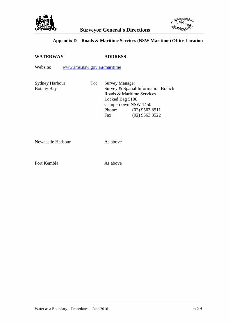
Appendix D – Roads & Maritime Services (NSW Maritime) Office Location
WATERWAY ADDRESS
Website: www.rms.nsw.gov.au/maritime
Sydney Harbour To: Survey Manager
Botany Bay Survey & Spatial Information Branch
Roads & Maritime Services
Locked Bag 5100
Camperdown NSW 1450
Phone: (02) 9563 8511
Fax: (02) 9563 8522
Newcastle Harbour As above
Port Kembla As above
Surveyor General's Directions
Water as a Boundary – Procedures – June 2016 6-30
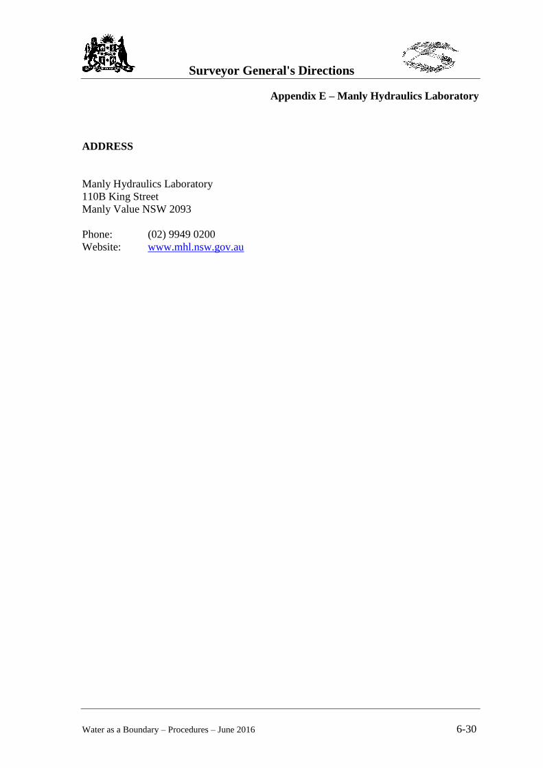
Appendix E – Manly Hydraulics Laboratory
ADDRESS
Manly Hydraulics Laboratory
110B King Street
Manly Value NSW 2093
Phone: (02) 9949 0200
Website: www.mhl.nsw.gov.au
Surveyor General's Directions
Water as a Boundary – Procedures – June 2016 6-31
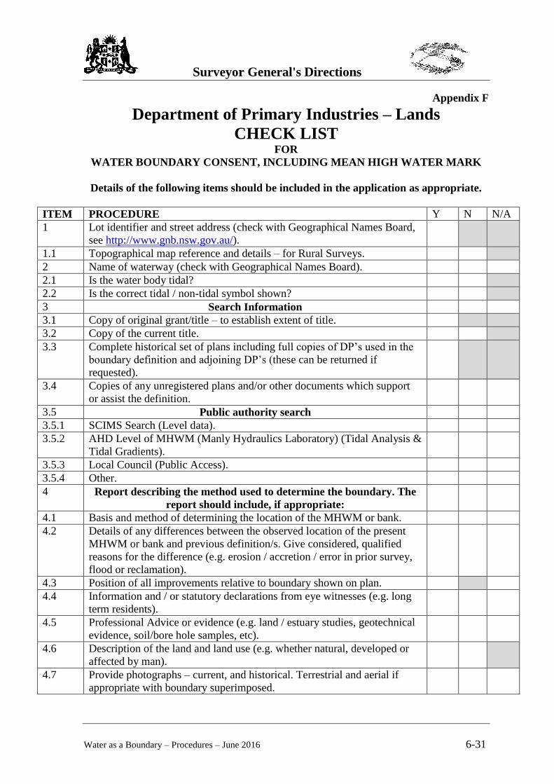
Appendix F
Department of Primary Industries – Lands
CHECK LIST FOR
WATER BOUNDARY CONSENT, INCLUDING MEAN HIGH WATER MARK
Details of the following items should be included in the application as appropriate.
ITEM PROCEDURE Y N N/A
1 Lot identifier and street address (check with Geographical Names Board,
see http://www.gnb.nsw.gov.au/).
1.1 Topographical map reference and details – for Rural Surveys.
2 Name of waterway (check with Geographical Names Board).
2.1 Is the water body tidal?
2.2 Is the correct tidal / non-tidal symbol shown?
3 Search Information
3.1 Copy of original grant/title – to establish extent of title.
3.2 Copy of the current title.
3.3 Complete historical set of plans including full copies of DP’s used in the
boundary definition and adjoining DP’s (these can be returned if
requested).
3.4 Copies of any unregistered plans and/or other documents which support
or assist the definition.
3.5 Public authority search
3.5.1 SCIMS Search (Level data).
3.5.2 AHD Level of MHWM (Manly Hydraulics Laboratory) (Tidal Analysis &
Tidal Gradients).
3.5.3 Local Council (Public Access).
3.5.4 Other.
4 Report describing the method used to determine the boundary. The
report should include, if appropriate:
4.1 Basis and method of determining the location of the MHWM or bank.
4.2 Details of any differences between the observed location of the present
MHWM or bank and previous definition/s. Give considered, qualified
reasons for the difference (e.g. erosion / accretion / error in prior survey,
flood or reclamation).
4.3 Position of all improvements relative to boundary shown on plan.
4.4 Information and / or statutory declarations from eye witnesses (e.g. long
term residents).
4.5 Professional Advice or evidence (e.g. land / estuary studies, geotechnical
evidence, soil/bore hole samples, etc).
4.6 Description of the land and land use (e.g. whether natural, developed or
affected by man).
4.7 Provide photographs – current, and historical. Terrestrial and aerial if
appropriate with boundary superimposed.
Surveyor General's Directions
Water as a Boundary – Procedures – June 2016 6-32
5 Modified Doctrine of Accretion
5.1 Is the new MHWM definition indefinitely sustainable by natural means?
5.2 Is Public Access likely to be restricted or denied?
6 Copy of Fieldnotes (relating to the measurement of the MHWM).
7 Observed a MHW tide to confirm definition?
8 Fee.
9 Three (3) signed and dated copies of plan.
Name of Surveyor:
Date:
Signed by Surveyor:
Surveyor General's Directions
Water as a Boundary – Procedures – June 2016 6-33
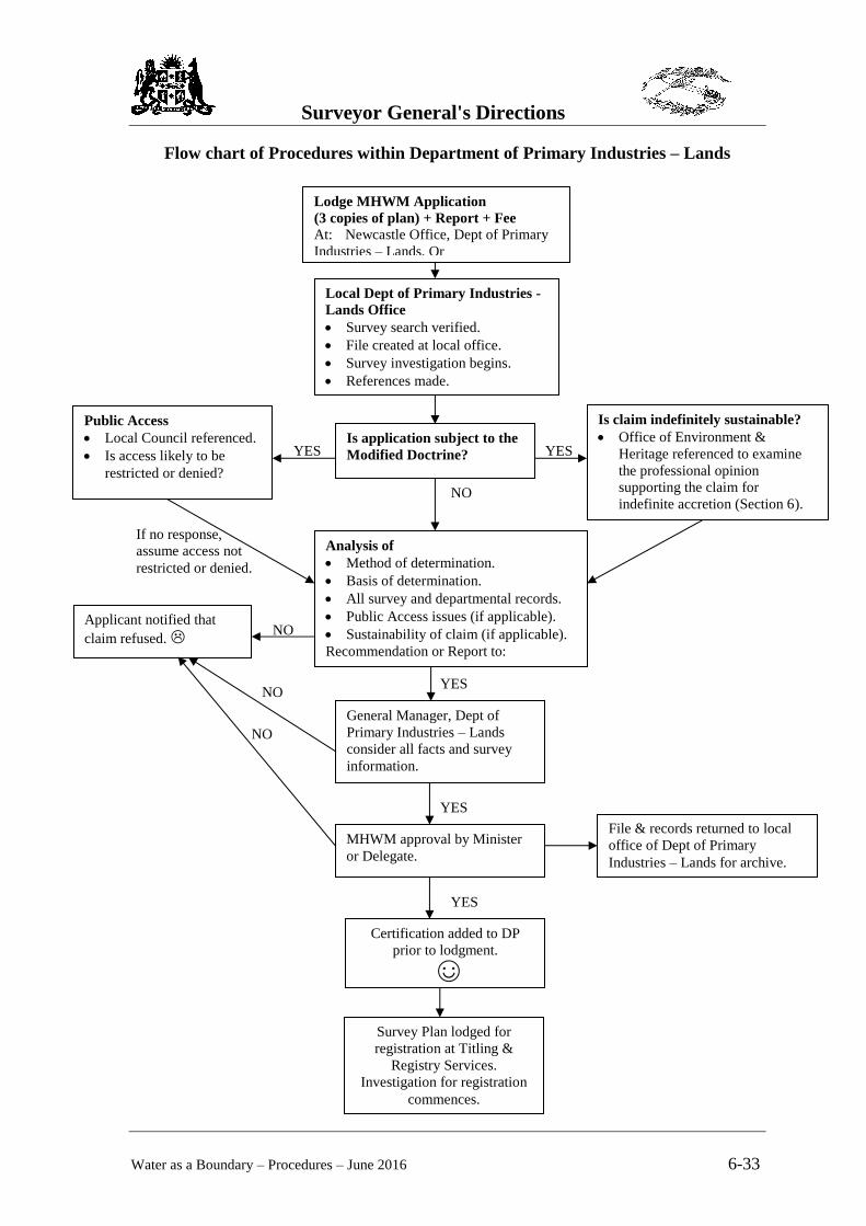
Flow chart of Procedures within Department of Primary Industries – Lands
Lodge MHWM Application
(3 copies of plan) + Report + Fee
At: Newcastle Office, Dept of Primary
Industries – Lands, Or
Local Dept of Primary Industries -
Lands Office
Survey search verified.
File created at local office.
Survey investigation begins.
References made.
Public Access
Local Council referenced.
Is access likely to be
restricted or denied?
Is claim indefinitely sustainable?
Office of Environment &
Heritage referenced to examine
the professional opinion
supporting the claim for
indefinite accretion (Section 6).
SGD)
Analysis of
Method of determination.
Basis of determination.
All survey and departmental records.
Public Access issues (if applicable).
Sustainability of claim (if applicable).
Recommendation or Report to:
Applicant notified that
claim refused. NO
General Manager, Dept of
Primary Industries – Lands
consider all facts and survey
information.
YES
NO
MHWM approval by Minister
or Delegate.
YES
Certification added to DP
prior to lodgment.
☺
YES
File & records returned to local
office of Dept of Primary
Industries – Lands for archive.
If no response,
assume access not
restricted or denied.
NO
Is application subject to the
Modified Doctrine? YES YES
NO
Survey Plan lodged for
registration at Titling &
Registry Services.
Investigation for registration
commences.