surveying technical language
DESCRIPTION
surveyTRANSCRIPT

Azad University of Shahrood
Surveying Engineering Faculty
Technical Language Lesson
Instructor: Bahram Safaee
Fall 2009

"Program of Teaching Technical Language Lesson for B.Sc. Students"
Introducer: Bahram safaee Email: [email protected]
Website: www.geocities.com/bssafaee/index.html
Session Number Date Topic
1
Global lesson & start of surveying words
2
Introducing surveying words
3
Asking surveying words & translating a surveying text
4
Introducing Route surveying & Cartography words
5
Asking Route surveying & Cartography words & translating their texts
6
Introducing Adjustment & Hydrography words
7
Asking Adjustment & Hydrography words & translating their texts
8
Introducing Geodesy & Astronomy words
9
Asking Geodesy & Astronomy words & translating its texts
10
Introducing GPS & Software words
11
Asking GPS words & translating its texts
12
Introducing Photogrammetry words
13
Asking Photogrammetry words & translating its texts
14
Introducing RS & GIS words
15
Asking RS & GIS words
16
Translating RS & GIS texts
Technical Language (Surveying Engineering)
Types of Surveying Surveying
The determination of the absolute and relative positions of points, on or near the earth's surface, by means of measurement in the three elements of space; distance, direction and elevation, and hence their subsequent representation onto a plane surface, exhibiting them in their correct horizontal and vertical relationships.
Route Surveying a survey which supplies the data necessary to determine alignment, grades, and earthwork quantities for the design & construction of various engineering projects such as roads, railroads, pipelines and utilities
Cartography The art and science of the production of maps. This includes the construction of projections, design, compilation, drafting and reproduction
Theory of errors Adjustment
Process designed to remove inconsistencies in measured or computed quantities by applying derived corrections to compensate for random or accidental errors.
Cadastral system Public record of the extent, value, and ownership of land within a district for taxation. The word comes from the Latin word cadastre referring to a registry of lands.
Hydrography The science that deals with the measurement and description of the physical features of the land beneath oceans, seas, lakes, rivers, and their adjoining coastal areas. Hydrographic surveys are useful for measuring erosion, guiding dredging projects, exploring for oil and rare mineral deposits, and marking underwater hazards.
Geodesy The science of measurement and mathematical description of the size and shape of the Earth taking into account its gravitational fields and the precise location of points on its surface.
Astronomy The branch of science focusing on celestial objects, dealing with their size, location, composition, dynamics, origin, etc.
Global Positioning System (GPS) The GPS is a constellation of 24 satellites orbiting the earth twice a day. A ground receiver calculates its geographic position by determining its relative position to a set of at least four satellites. The receiver can calculate the exact location (usually within a centimeter) of an object on the surface of the Earth.
Geographic Information System (GIS) A collection of computer hardware, software, and geographic data designed to capture, store, update, manipulate, analyze, and display geographically referenced data. The surveyor is the one who collects, analyzes, and reports the geographic data. In combination with geographic data, a GIS study may include other data sets: sales figures, population census, real estate, and illness rates.
Photogrammetry
A 3D coordinate measuring technique that uses photographs or other remote sensing systems in conjunction with on-the-ground survey reference points—called ground controls—as the fundamental medium for measurement. 3 dimensional
Remote Sensing (RS) The measurement of information about an object by a recording device without coming into physical contact with the object. Remote sensing involves the use an aircraft, spacecraft, satellites, or ships for gathering information pertinent to the environment, such as measurements of electromagnetic radiation, infrared sensing, land use, and water bodies. Such systems typically use devices such as cameras, lasers, radio frequency receivers, radar systems, infrared detectors, sonar seismographs, gravimeters and magnetometers. Some Terms FAQ frequently asked questions Index of books E-book Abbreviation Acronym
[email protected] Lesson 1 & 2 ((Words)) 3
Technical Language (Surveying Glossary)
Absolute Coordinates Accuracy
The closeness of the results of observations, computations or estimates to the true values or the values accepted as being true. Accuracy relates to the exactness of the operation by which the result is obtained.
Acre
The (English) acre is a unit of area equal to 43,560 square feet cubic feet Aim Alidade
Instrument, or part of an instrument , for determining direction , either horizontal or vertical . Alphanumeric Altitude
The vertical angle between the plane of the horizon and the line to the object which is observed. In photogrammetry, altitude applies to elevation above a datum of points in space.
Aneroid barometer
An instrument used to obtain heights above sea level by measuring atmospheric pressure. Arc
A locus of points that forms a curve that is defined by a mathematical function Area
A bounded contiguous two dimensional object which may or may not include its boundary Azimuth
The horizontal angle to a line of sight, measured clockwise from a north meridian. Counter clockwise
CW & CCW
Clockwise & Counter Clockwise Backsight
(1) In leveling, a sight taken to a point of known elevation, thus permitting the surveyor to compute the elevation of the instrument. (2) In traverse work, a sight taken to a previously located point to establish a reference for angular measurement.
Baseline
[email protected] Lesson 1 & 2 ((Words)) 4
Base Mapping Usually associated with topographic mapping covering country or region at different scales.
Bearing
The direction of a line with respect to the meridian described by degrees, minutes, and seconds within a quadrant of the circle. Bearings are measured clockwise or counterclockwise from north or south, depending on the quadrant.
Bench mark Cadastral
A Latin term from 'cadastre' referring to a registry of lands. Cadastral surveying is the process of determining and defining land ownership and boundaries
Cartesian Coordinates
Numbers expressing the location of a point in two or three dimensions as the perpendicular distances from two or three orthogonal axes.
Chart Closed traverse
A survey traverse which starts and ends on known control stations. Compass Contour interval
The difference in elevation between adjacent contours as delineated on a map. Contours
Lines joining points of equal height as shown on a topographic map. Contour lines that are relatively close together depict an area of steep terrain on the earth's surface.
Curvature correction Data collector
An electronic field book designed to store field data, both measured and descriptive Datum
A mathematical representation that best fits the shape of the earth. Delauney triangulation Digital Elevation Model (DEM)
A 3D representation of the height and shape topography of the Earth's surface. A DEM is formed by a regular grid of height values and can be overlayed with other data to create DTM.
Digital Terrain Model (DTM)
A 3D representation of the Earth's surface. It's construction includes a height model (i.e. a DEM) and overlaid with map data relating to features on the surface (i.e. Map Data or Aerial Photograph).

[email protected] Lesson 1 & 2 ((Words)) 5
EDM Electromagnetic Distance Measurement device, the instrument used by surveyors to measure distance. It determines distance by measuring the time it takes for laser light to reflect off a prism on top of a rod at the target location.
Elevation
The height above mean sea level. Error
The difference between a measured value and the true value. Error in measurement is inherent, but is separate and distinct from a blunder (a mistake)
Expansion factor Face Left
Face Left refers to the position of a theodolite when the vertical circle is situated to the left hand side of the observer's face.
Face Right
Face Right refers to the position of a theodolite when the vertical circle is situated to the right hand side of the observer's face.
Foresight
An observation to the next instrument station. The reading on a rod that is held at a point whose elevation is to be determined.
Geocentric datum
A datum which has its origin at the Earth's centre of mass. Geographical coordinates
A point on a map given as latitude and longitude readings. The values are given as degrees, minutes and seconds
Graticule
A network of crossing lines on a map representing parallels of latitude and meridians of longitude as defined by the projection
Gravity
Combined acceleration potential of an object due to gravitation and centrifugal forces. Grid
A group of parallel lines that run perpendicular to another group of parallel lines to form a map coverage of squares.
Grid coordinates
A point on a map given as an easting and northing reading. The values are given in metres.

[email protected] Lesson 1 & 2 ((Words)) 6
Grid north The direction of the vertical grid lines shown on a topographic map. The difference between grid north and true north is referred to as grid convergence.
Gyrotheodolite
A gyroscopic device used to measure azimuth that is built-in or attached to a theodolite. Hectare
Metric unit of area equal to 10,000 square meters. Height of instrument (HI)
Height of the optical axis of the instrument above the station (bench mark). Horizontal Angle
A horizontal angle is the angle formed in a horizontal plane by two intersecting vertical planes. Hydrographic Surveying
The measurement and description of the physical features offshore and adjoining coastal areas with special reference to their use for the purpose of navigation
Hypsometric tinting
The use of different colours to signify changing elevations on a topographic map Indirect Leveling
The determination of differences of elevation from vertical angles and horizontal distances International System of Units (SI) Interpolation
The estimation of values of a surface at an unsampled point based on the known values of surrounding points
Intersection method
A method of determining the horizontal position of a point by observations from two or more points of known position, thus measuring directions that intersect at the station being located
Laser light
Visible light of a single wavelength emitted in a tight coherent beam Latitude
The angular distance along a meridian measured from the Equator, either north or south. Leveling
Surveying operation in which heights of objects and points are determined relative to a specified datum
LIS
Land Information System
[email protected] Lesson 1 & 2 ((Words)) 7
Longitude The angular distance measured from a reference meridian, Greenwich, either east or west.
LSE: Least Squares Estimation
A computation process which is based on linear equations describing the relationship between the measurements and the unknown parameters (usually station or point coordinates), and assumes that the measurements have a normal distribution of error. The sum of the squares of the errors in the measurements is minimized to obtain the solution, which includes the most probably true
Magnetic declination
The angle between the magnetic and geodetic meridian at any place, expressed in degrees east or west to indicate the direction of magnetic north from true north.
Magnetic north Magnification Map
A representation of the earth's surface Map projection
A means of systematically representing the meridians and parallels of the earth onto a plane surface
Map scale
The relationship between a distance on a map and the corresponding distance on the earth's surface
Measurement Meridian
A straight line connecting the North and South Poles and traversing points of equal longitude Monument
An object placed to mark the physical location of a position. Mosaic
A number of continuous aerial photographs overlapped and joined together by way of 'best fit' to form a single image
Mean sea level (MSL)
The average height of the surface of the sea for all stages of the tide. Elevations used to be commonly referenced to MSL. Since MSL is not a constant elevation at different locations it is no longer used as a reference for elevations.
Neatline
The outer grid lines, forming the boundary of the map sheet

[email protected] Lesson 1 & 2 ((Words)) 8
NCC National Cartographic Center
Open Traverse PK
Point Known Planimetric Map
A map representing only the horizontal position of features Position
Data which define the location of a point with respect to a reference system. Parts per million (ppm)
An amount of error proportional to the distance measured Precision
The repeatability of a measurement Pressure Prism Prism Constant (PC) Refraction
The bending of rays by the substance through which the rays pass. The amount and direction of bending are determined by its refractive index.
Reflector
A telescope which uses a parabolic mirror at its base to collect light and focus it into an eyepiece for viewing
Reliability
The ability to detect errors in survey measurements Resection (Free Station)
The determination of horizontal position of a survey station by observed directions or lengths from the station to points with known positions
Rod
A rod is essentially a stick with precise markings on it. Scale factor
The multiplying factor used to convert a geodetic distance to a grid distance. A number by which a distance obtained from a map by computation or measurement is multiplied to obtain the actual distance on the datum of the map.
[email protected] Lesson 1 & 2 ((Words)) 9
stadia Technique of distance measurement
Staff (Leveling Rod)
A staff is a measuring bar which has marked with gradations. Staking stake out
The placement of markers on a site to identify certain locations (such as the corners of a building, the right-of-way of a road, etc.) with corresponding information (such as cut or fill for earthmoving) It is the transferal of information from the plan to the actual site
Survey Network
A conglomeration of survey measurements and stations. The defining characteristic of a survey network is that there are more measurements taken than are required to define the survey station coordinates. The additional measurements are acquired to allow checks on the data in order to detect errors in the measurements, as well as to improve the precisions and reliabilities of the station coordinates.
Surveyor Theodolite
Instrument used by a surveyor for measuring horizontal and vertical angles. Topography
The graphic portrayal of a land parcel’s configuration in map form, as shown by contour lines that shows the elevation (relief) of the land surface.
Total Station
An electronic theodolite combined with an EDM instrument and an electronic data collector. Traverse
A method of surveying in which lengths and directions of lines between points are obtained from field measurements, and used in determining positions of the points.
Triangulation Tribrach
The three-armed base, of a surveying instrument, in which the foot screws used in leveling the instrument are placed at the ends of the arms.
Trigonometrical survey
A concise method of surveying in which the stations are points on the ground located at vertices of a chain or network of triangles. The angles of the triangles are measured instrumentally and the sides are derived by computation from selected sides termed as baselines.
Trilateration
A method of surveying wherein the lengths of the triangle sides are measured and the angles are computed from the measured lengths.
[email protected] Lesson 1 & 2 ((Words)) 10
Tripod The three-legged stand upon which surveying instruments and targets are mounted during use.
True north
The direction to the Earth's geographic North Pole. Turn
The Rodman is told to stay in place while the gun or level is moved to a new location. Turning Point (TP)
In differential leveling, a point, the height of which is determined before the leveling instrument is moved, used to determine the height of the instrument after resetting
Vertical Angle Waving the rod
The slight waving of the level rod to and from the instrument, which permits the surveyor to take a precise (lowest) rod reading.
Zenith Angle
Measured in a positive direction downwards from the observer's zenith to the observed target.
THE END
Of
Surveying Vocabylaries

[email protected] Lessons 1 & 2 ((Texts)) 11
Technical Language (Surveying Article)
Main purposes of surveying
1. To produce up-to-date Engineering Plans of the areas in which the work will be carried out. These plans form the basis for the design of the construction, and so the reliability of the design depends heavily on the attention to detail with which the survey is carried out.
2. To determine the required areas and volumes of land and materials needed during construction.
3. To ensure that the construction takes place in the correct relative and absolute position on the ground.
4. To record the final position of the construction, including any design changes.
5. To provide permanent control points from which particularly important projects can be surveyed.
Land Surveying
What is Land Surveying?
Land surveying is known as the world's second-oldest profession. It dates back to ancient Egypt and Babylonia. Surveying is essentially the art and science of measuring and mapping land. Without this service, railroads could not be built, skyscrapers could not be erected, and individuals could not put up fences around their yards, for fear of trespassing on someone else's land. Would you like an interstate highway to be built in your backyard, one you've paid for, maintained, and paid taxes on for years, without your permission? Of course, how would you know it was in your backyard without a surveyor to tell you where your property even was? We also stake out boundaries of roads to be built, monitor skyscrapers to make sure they are being erected vertically, and measure airports so that the runways are perfectly aligned and smooth. So, if you see a guy in the road looking through an instrument on a tripod, which is a surveyor, now you know that he is doing more than taking pictures.
Traditional Total Station Surveying
Our most important tool for surveying is total station. It's given this name because it incorporates a distance meter for measuring distances and a theodolite for measuring angles into one instrument.
The total station measures by sending a beam of infrared light toward a prism, usually supported either by a tripod or a pole. The light reflects off the prism directly back to the total station. By measuring the time it takes for the light to return, the total station calculates the distance away that the prism is.
The information that the total station measures (angles and distances) is recorded in a data collector for later downloading into a computer in the office
Total stations were first developed in the 1980s by Hewlett-Packard (Brinker and Minnick 1995). These instruments sensed horizontal and vertical angles electronically instead of optically, and combined them with an EDM slope distance to output the X-Y-Z coordinates of a point relative to

[email protected] Lessons 1 & 2 ((Texts)) 12
the instrument's X-Y-Z coordinates. Electronic theodolites operate in a manner similar to optical instruments.
These instruments also are equipped with a dual-axis compensator, which automatically corrects both horizontal and vertical angles for any deviation in the plumb line. An EDM device is added to the theodolite and allows for the simultaneous measurements of the angle and the distance. With the addition of a data collector, the total station interfaces directly with onboard microprocessors, external PCs, and software. The ability to perform all measurements and to record the data with a single device has revolutionized surveying.
Types of measurements:
• Slope distance
• Horizontal angle
• Vertical angle
In general, there are three types of total station operating modes:
• Reflector--total station requires a solid reflector signal return from the remote point to resolve digital angles and distances. Prisms are attached to a pole positioned over a feature. Requires two-man field crew--operator and rodman.
• Reflectorless--the total station will resolve (and coordinate) signal returns off natural features. Distances may be far more limited than those obtained from reflectors ... typically less than 1,000 ft. Allows for more economical one-man field crew operation.
• Robotic--total station self-tracks single operator/rodman at remote shot or stakeout points. One man crew operation, with operator normally based at remote rod point.
THE END
Of
Surveying Texts

[email protected] Lesson 3 & 4 ((Words)) 13
Technical Language (Route Surveying Glossary)
AASHTO American Association of State Highway and Transportation Officials
Centerline Chainage
A distance, usually in meters, measured from the start of the scheme, to a particular point on the centerline
Chord Curve, circular
A curve of constant radius
Curve, Compound Name for two circular curves of different radii, which are tangent at one point with both curves lying on the same side of the common tangent
Curve, Reverse Curve, Spiral
A curve that has a varying radius
Cut-and-Fill Cross-Section Dike
An embankment to confine or control water
Embankment Grade
The slope of a road, a channel, or natural ground
Gradient A change of elevation, velocity, pressure, or other characteristics per unit length. (2) Slope.
Intersection angle (I) The intersecting angle is the deflection angle at PI.
Long Chord The straight-line distance from the TC to the CT
Longitudinal section Point of intersection (PI)
The point where two tangents meet. Sometimes is called Vertex (V).
Profile A vertical section of the surface of the ground, or of underlying strata, or both, along any fixed line
Radius Superelevation
The banking of a curved section of road to help overcome the effects of centrifugal force
Tangent A straight line that touches a given curve at one and only one point and doesn’t intersect it
[email protected] Lesson 3 & 4 ((Words)) 14
Technical Language (Cartography Glossary)
Azimuthal Projection Bathymetry
Conformal Projection A projection that can accurately preserve the shape of mapped entities with the drawback of scalar and area distortion. All projections introduce some distortion into the Cartesian results;
Conic Projection A projection based on the geometry of the cone.
Cyan, Magenta, Yellow, Black (CMYK) Cylindrical Projection Equal Area Projection
A projection that accurately preserves the area of objects
Equidistant Projection A projection that accurately preserves the distance between certain objects
Hachure Lambert conformal projection Map
Graphic representation of the physical features (natural, artificial, or both) of a part or the whole of the Earth's surface, by means of signs and symbols or photographic imagery, at an established scale, on a specified projection
Map digitization Conversion of map data from graphic to digital form
Map, geologic Map, land use Map, planimetric
Map that presents only the horizontal positions for features represented. Distinguished from a topographic map by the omission of relief in measurable form
Map, Scale The relationship existing between a distance on a map and the corresponding distance on the earth
Map, thematic Map designed to provide information on a single topic, such as geology, rainfall, population
Map, topographic Mercator projection
A conformal cylindrical projection tangential to the Equator
Metric system North American Datum of 1983 (NAD 83)
Reference surface for horizontal positions
Origin of coordinates Point in a system of coordinates that serves as a zero point in computing the system's elements or in prescribing its use

[email protected] Lesson 3 & 4 ((Words)) 15
Plain
Region of uniform general slope, comparatively level, of considerable extent, and not broken by marked elevations and depressions
Relief Elevations and depressions of the land or sea bottom
Relief shading Technique for making hypsography on a map appear three dimensional by the use of graded shadow effects. Generally, the features are shaded as though illuminated from the northwest
Elevation Spot Point on a map or chart whose height above a specified datum is noted, usually by a dot and elevation value
Universal Transverse Mercator (UTM) grid Military grid system based on the transverse Mercator projection, applied to maps of the Earth's surface extending from the Equator to 84 Degrees north and 80 degrees south latitudes
WGS84 (World Geodetic System 1984) A global datum that is based on electronic technology, which is still to some degree classified, GPS is based on this datum. The difference between WGS 84 and NAD 83 is small and is generally considered to be insignificant
THE END
Of
Route Surveying & Cartography Vocabylaries
[email protected] Lesson 3 & 4 ((Texts)) 16
Technical Language (Route Surveying Article)
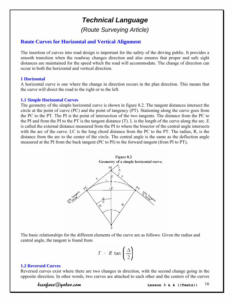
Route Curves for Horizontal and Vertical Alignment The insertion of curves into road design is important for the safety of the driving public. It provides a smooth transition when the roadway changes direction and also ensures that proper and safe sight distances are maintained for the speed which the road will accommodate. The change of direction can occur in both the horizontal and vertical direction. 1 Horizontal A horizontal curve is one where the change in direction occurs in the plan direction. This means that the curve will direct the road to the right or to the left. 1.1 Simple Horizontal Curves The geometry of the simple horizontal curve is shown in figure 8.2. The tangent distances intersect the circle at the point of curve (PC) and the point of tangency (PT). Stationing along the curve goes from the PC to the PT. The PI is the point of intersection of the two tangents. The distance from the PC to the PI and from the PI to the PT is the tangent distance (T). L is the length of the curve along the arc. E is called the external distance measured from the PI to where the bisector of the central angle intersects with the arc of the curve. LC is the long chord distance from the PC to the PT. The radius, R, is the distance from the arc to the center of the circle. The central angle is the same as the deflection angle measured at the PI from the back tangent (PC to PI) to the forward tangent (from PI to PT).
The basic relationships for the different elements of the curve are as follows. Given the radius and central angle, the tangent is found from
1.2 Reversed Curves Reversed curves exist where there are two changes in direction, with the second change going in the opposite direction. In other words, two curves are attached to each other and the centers of the curves
[email protected] Lesson 3 & 4 ((Texts)) 17
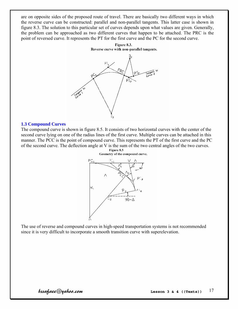
are on opposite sides of the proposed route of travel. There are basically two different ways in which the reverse curve can be constructed: parallel and non-parallel tangents. This latter case is shown in figure 8.3. The solution to this particular set of curves depends upon what values are given. Generally, the problem can be approached as two different curves that happen to be attached. The PRC is the point of reversed curve. It represents the PT for the first curve and the PC for the second curve.
1.3 Compound Curves The compound curve is shown in figure 8.5. It consists of two horizontal curves with the center of the second curve lying on one of the radius lines of the first curve. Multiple curves can be attached in this manner. The PCC is the point of compound curve. This represents the PT of the first curve and the PC of the second curve. The deflection angle at V is the sum of the two central angles of the two curves.
The use of reverse and compound curves in high-speed transportation systems is not recommended since it is very difficult to incorporate a smooth transition curve with superelevation.
[email protected] Lesson 3 & 4 ((Texts)) 18
Optional Study .
Technical Language
(Cartography Article) Horizontal Coordinate Systems Geographic Coordinates The use of geographic coordinates as a system of reference is accepted worldwide. It is based on the expression of position by latitude (parallels) and longitude (meridians) in terms of arc (degrees, minutes, and seconds) referred to the equator (north and south) and a prime meridian (east and west). The degree of accuracy of a geographic reference (GEOREF) is influenced by the map scale and the accuracy requirements for plotting and scaling. Examples of GEOREFs are as follows:
40° N 132° E (referenced to degrees of latitude and longitude). 40°21' N 132°14' E (referenced to minutes of latitude and longitude).
40°21'12" N 132°14'18" E (referenced to seconds of latitude and longitude). 40°21'12.4" N 132°14'17.7" E (referenced to tenths of seconds of latitude and longitude).
40°21'12.45" N 132°14'17.73" E (referenced to hundredths of seconds of latitude and longitude).
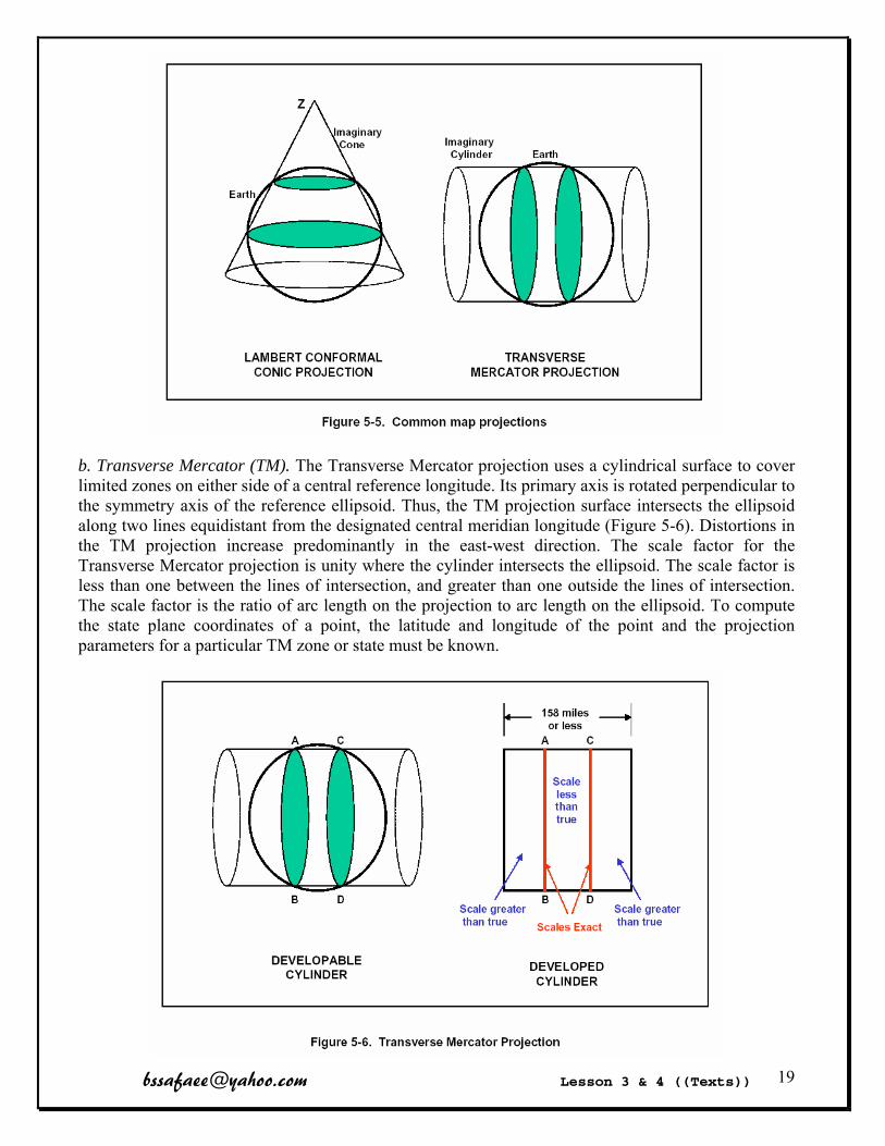
US military maps and charts include a graticule (parallels and meridians) for plotting and scaling geographic coordinates. Graticule values are shown in the map margin. On maps and charts at scales of 1:250,000 and larger, the graticule may be indicated in the map interior by lines or ticks at prescribed intervals (for example, scale ticks and interval labeling at the corners of 1:50,000 at 1minute [in degrees, minutes, and seconds] and again every 5 minutes). State Plane Coordinate Systems A. General. State Plane Coordinate Systems (SPCS) were developed by the National Geodetic Survey (NGS) to provide plane coordinates over a limited region of the earth’s surface. To properly relate geodetic coordinates (Ф-λ-h) of a point to a 2D plane coordinate representation (Northing, Easting), a conformal mapping projection must be used. Conformal projections have mathematical properties that preserve differentially small shapes and angular relationships to minimize the errors in the transformation from the ellipsoid to the mapping plane. Map projections that are most commonly used for large regions are based on either a conic or a cylindrical mapping surface (Figure 5-5 below). The projection of choice is dependent on the north-south or east-west areal extent of the region. Areas with limited east-west dimensions and indefinite north-south extent use the Transverse Mercator (TM) type projection. Areas with limited north-south dimensions and indefinite east-west extent use the Lambert projection. The SPCS is designed to minimize the spatial distortion at a given point to approximately one part in ten thousand (1:10,000). To satisfy these criteria, the SPCS has been divided into zones that have a maximum width or height of approximately one hundred and fifty eight statute miles (158 miles). Therefore, each state may have several zones or may employ both the Lambert (conic) and Transverse Mercator (cylindrical) projections. The projection state plane coordinates are referenced to a specific geodetic datum (i.e. the datum that the initial geodetic coordinates are referenced to must be known).
[email protected] Lesson 3 & 4 ((Texts)) 19
b. Transverse Mercator (TM). The Transverse Mercator projection uses a cylindrical surface to cover limited zones on either side of a central reference longitude. Its primary axis is rotated perpendicular to the symmetry axis of the reference ellipsoid. Thus, the TM projection surface intersects the ellipsoid along two lines equidistant from the designated central meridian longitude (Figure 5-6). Distortions in the TM projection increase predominantly in the east-west direction. The scale factor for the Transverse Mercator projection is unity where the cylinder intersects the ellipsoid. The scale factor is less than one between the lines of intersection, and greater than one outside the lines of intersection. The scale factor is the ratio of arc length on the projection to arc length on the ellipsoid. To compute the state plane coordinates of a point, the latitude and longitude of the point and the projection parameters for a particular TM zone or state must be known.
[email protected] Lesson 3 & 4 ((Texts)) 20
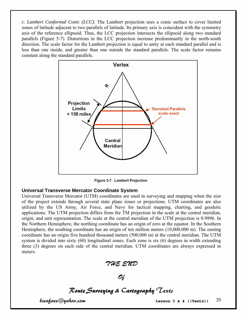
c. Lambert Conformal Conic (LCC). The Lambert projection uses a conic surface to cover limited zones of latitude adjacent to two parallels of latitude. Its primary axis is coincident with the symmetry axis of the reference ellipsoid. Thus, the LCC projection intersects the ellipsoid along two standard parallels (Figure 5-7). Distortions in the LCC projection increase predominantly in the north-south direction. The scale factor for the Lambert projection is equal to unity at each standard parallel and is less than one inside, and greater than one outside the standard parallels. The scale factor remains constant along the standard parallels.
Universal Transverse Mercator Coordinate System Universal Transverse Mercator (UTM) coordinates are used in surveying and mapping when the size of the project extends through several state plane zones or projections. UTM coordinates are also utilized by the US Army, Air Force, and Navy for tactical mapping, charting, and geodetic applications. The UTM projection differs from the TM projection in the scale at the central meridian, origin, and unit representation. The scale at the central meridian of the UTM projection is 0.9996. In the Northern Hemisphere, the northing coordinate has an origin of zero at the equator. In the Southern Hemisphere, the southing coordinate has an origin of ten million meters (10,000,000 m). The easting coordinate has an origin five hundred thousand meters (500,000 m) at the central meridian. The UTM system is divided into sixty (60) longitudinal zones. Each zone is six (6) degrees in width extending three (3) degrees on each side of the central meridian. UTM coordinates are always expressed in meters.
THE END
Of
Route Surveying & Cartography Texts

[email protected] Lesson 5 & 6 ((Words)) 21
Technical Language (Adjustment Glossary) Blunder
A mistake or gross error Incorrectly measured or recorded data by an observer or recorder resulting from carelessness or confusion.
Chi-square test A statistical test on the standard error of unit weight
Closure Agreement between computed and known parts of a control network
Confidence Interval This is the percentage of probable occurrences that fall within the interval. This value may be expressed graphically as an error ellipse. The larger the error ellipse, the greater the confidence interval
Constraint External limitations imposed upon the adjustable quantities (observations and coordinates) in a network adjustment.
Degrees of freedom The number of observations which are in excess of the number actually needed to calculate the unknowns.
Eigenvalues Error
The difference between an observed or computed value of a quantity and the theoretical or defined value of that quantity
Error ellipse Error Propagation Least-squares adjustment
A method of adjusting observations by producing the smallest change to the original field measurements
Level of significance Mistake
A mistake is not an error, but is a blunder on the part of the observer.
PDF probability density function Random errors
Errors which do not follow physical laws nor can be defined mathematically, as an example: bubble not centered at the instant a level rod is read.
Residual The difference between any measured quantity and the most probable value for that quantity.
RMS Root-Mean-Square - a statistical measure of the dispersion or spread of a group of data. The name comes from the fact that the RMS is equal to the square Root of the Mean (average) of the sum of Squares of the values in the data set.
[email protected] Lesson 5 & 6 ((Words)) 22
Standard deviation
A value expressing precision which is defined as the square root of the variance
Systematic error An error in a measured value which follows some physical law or which can be expressed as a mathematical function
Variance ((add (sum, plus) subtract multiply divide)) The sum of the squares of the residuals divided by the number of measurements
Weights This is the reciprocal of the square of the standard deviation. You can apply a smaller standard deviation to measurements that you feel are stronger, as they will be assigned larger weights and will not be adjusted as much as the smaller weighted measurements.
[email protected] Lesson 5 & 6 ((Words)) 23
Technical Language (Hydrography Glossary)
Bathymetry The measurement of depth in large bodies of water
Buoy Anchored float used as a guide to navigators
Coastline A line that follows the main outline of the land, including bays, but crosses rivers at their mouths
Dam Echo sounder Humidity The presence of water vapor in air
Lidar Light Detection and Ranging
Marine Of the sea, of the ocean
MBES Multibeam echo sounders
MSL Mean Sea Level
Mouth The place where a stream enters a larger body of water
NT Neap Tide
Seabed Bottom of a sea or ocean
Sonar SOund NAvigation and Ranging
ST Spring Tide
Sound Velocity Tide Periodic rise and fall of the water resulting from gravitational interactions
between the sun, moon, and Earth.
Tide gauge An instrument for measuring the rise and fall of the tide (water level)
Watercourse Stream, water channel
Well A pit or hole dug or bored into the earth for the extraction of Water
THE END
Of
Adjustment & Hydrography Vocabylaries

[email protected] Lesson 5 & 6 ((Texts)) 24
Technical Language (Adjustment Article)
Error Propagation
This article investigates how relatively small measurement errors can spread through a survey network and cause significantly larger computational errors. To do this we must look at a topic called error propagation. Before beginning a discussion about error propagation it is worthwhile to review the two types of errors encountered in surveying. They are systematic errors and random errors.
Systematic errors are cumulative in nature. They can be modeled by mathematical functions, and once their value is computed they may be corrected for. An example of a systematic error is a 100 foot steel tape that is 0.015 foot too long (measures short). A line that is measured as 1000.000 feet with said tape should be reported to be 1000.000 + (10 x 0.015) = 1000.150 feet long. The systematic error in the measured value is - 0.150 feet. It is important to realize that these errors cannot be "adjusted out" of a network; they must be removed from survey data before an adjustment is performed. Instruments that are out of adjustment are a source of systematic error.
Random errors, on the other hand, cannot be described by a predetermined mathematical model; rather, they obey the laws of probability. If an observation is repeated over and over many times these errors will tend to cancel each other. An example of random error is the error that comes from interpolation. Consider the surveyor who runs a differential level loop recording his observations to the nearest 0.001 foot while reading a rod graduated to 0.01 foot. Some of his estimates will naturally be too high while others will be too low. However, the laws of probability say that in the long run the highs will probably cancel the lows. All measurements, no matter how carefully made, contain random error. Random errors may be estimated and accounted for by least squares adjustment techniques.
Some people describe blunders as a third class of errors. But technically they are not errors; they are mistakes caused by carelessness which cannot be adjusted for. Blunders must be isolated and removed from survey data before beginning an adjustment.
Another important set of concepts in assessing measurement errors is accuracy and precision. Accuracy denotes the nearness a measured value has to the true value while precision is an indicator of how near a set of repeated measurements are to one another. A measurement may be accurate without being precise and vice-versa. To illustrate the difference between the two consider the surveyor who has measured a set of distances with an EDM and recorded the following values: 110.151 m, 110.152 m, 110.151 m, 110.150 m. These measurements are closely grouped, having a precision of 0.002/110.151 = 1/55,000. But if later the surveyor discovered a 2 cm centering error in his instrument he then finds that his accuracy is only 0.02/110.151 = 1/5,500 which is inconsistent with the precision of his measurements. Conversely, a surveyor who has paced 665 feet between two points that are actually 660.00 feet apart is said to have an accurate pace, but of course this is not a very precise method of measurement. A good survey will maintain consistency between accuracy and precision.
Often times surveyors are not able to measure the geometric entity that they are really after but must make other measurements that will lead them to the values they want. For instance, a surveyor may have to measure several courses of a traverse to connect two control points. He is usually not interested in the distances and bearings of the traverse courses but he must measure them in order to
[email protected] Lesson 5 & 6 ((Texts)) 25
ascertain the bearing and distance between the control points. So the data he wants is not measured; it is computed. Error in this computed value is a function of the errors in the measured values and is evaluated by error propagation analysis
The general law of error propagation for a function of n variables is given below without derivation:
The partial derivative represents the change in the computed value y with respect to the measured
value , and , represents the standard error assigned to the measured value.
In the ideal situation where all systematic errors have been corrected before computations are started only random errors will propagate. This is unavoidable; random errors exist in every measurement.
A least squares adjustment program was used to adjust the traverse and compute error propagation for each point

[email protected] Lesson 5 & 6 ((Texts)) 26
Technical Language (Hydrography Article)
Astronomical Tide Producing Forces At the surface of the Earth, the Earth’s gravitational attraction acts in a direction inward toward its centre of mass and thus holds the ocean waters confined to this surface. However, the gravitational forces of the Moon and Sun, and centrifugal force of the Sun-Earth-Moon system, act externally upon the Earth's ocean waters. These external forces are exerted as tide-producing forces. Their affects are superimposed upon the Earth’s gravitational force and act to draw the ocean waters horizontally to various points on the Earth’s surface. A high tide is produced in ocean waters by the ‘heaping’ action resulting from the horizontal flow of water toward the region of maximum attraction of the combined lunar and solar gravitational forces. An additional high tide is produced at a position on the opposite side of the Earth, where the centrifugal force of the orbiting system overpowers the gravitational attraction of the Sun and Moon. Low tides are created by a compensating withdrawal of water from regions around the Earth midway between these two tidal bulges. The alternation of high and low tides is caused by the daily (or diurnal) rotation of the solid body of the Earth with respect to these two tidal bulges and the tidal depression. The changing arrival times of any two successive high or low tides at any one location are the result of numerous factors. Fundamental tide producing forces have two components due to the Sun (solar) and the Moon (lunar).
THE END
Of
Adjustment & Hydrography Texts
[email protected] Lesson 7 & 8 ((Words)) 27
Technical Language (Geodesy Glossary) Anomaly Atmosphere
The layer of gas which surrounds a celestial body
Celestial sphere An imaginary sphere of infinite radius concentric with the Earth on which all celestial bodies except the Earth are imagined to be projected
Centrifugal Force Force that moves objects or parts away from a center of rotation
Deflections of the vertical Deformation Displacement Earth
Our home planet and the third from the Sun
Earth Rotation Axis Eccentricity
Amount of deviation from center
Ellipse A flattened circle Johannes Kepler first postulated that the orbits of celestial bodies are eliptical and not circles
Ecliptic The plane of earth’s orbit about the sun
Ellipsoid semi-minor axis semi-major axis A mathematical best-fit representation of the Earth's surface formed by rotating an ellipse about its minor axis
Equinoxes The two points in the celestial sphere where the celestial equator intersects the ecliptic; also, the times when the Sun crosses the equator at these points.
Gal The unit of gravity (One Gal equals 1 cm/sec2)
Geodetic azimuth The clockwise angle measured usually from north between the mathematical reference geodetic meridian and the observed line.
Geoid The average position of mean sea level, the equipotential surface in the gravity field of the Earth which coincides with the undisturbed mean sea level extended continuously through the continents. The direction of gravity is perpendicular to the geoid at every point.
Geoid height (N) The distance of the geoid above (positive) or below (negative) the mathematical reference ellipsoid, (undulation)
Gravimeter
[email protected] Lesson 7 & 8 ((Words)) 28
Gravitation The force of attraction between two bodies, such as the Earth and our body
Gravitational acceleration
Gravity Force The sum of the gravitational and the centrifugal forces
IAG International Association of Geodesy
Isostasy Theory that the amount of material between the Earth’s surface and its center are equal in every location
IUGG International Union of Geodesy and Geophysics
Kepler equation Magnetometer Mean sea level
A tidal datum that is the arithmetic mean of hourly water elevations observed over a specific 19-year Metonic cycle (the National Tidal Datum Epoch).
Mean solar day The duration of one rotation of the earth on its axis, with respect to the mean sun The length of the mean solar day is 24 hours of mean solar time or 24h 03m 56.555s of mean sidereal time.
Nodal line Nutation Orthometric height
The elevation of a point above or below the geoid A relationship between ellipsoid height and orthometric height is obtained from the equation h=H+N Where: h = ellipsoid height, H = orthometric height, N = geoid height
Polar motion Potential Field Plumb-line Precession Prime meridian Reference ellipsoid
The reference surface (which takes the flattening effect of the earth's rotation into account) that represents the size and shape of the earth for cartography
Winter solstice The point on the ecliptic when the Sun is furthest south of the equator, giving the southern hemisphere its longest day of the year (and the shortest day of the year in the northern hemisphere) It occurs around December 21 and marks the beginning of winter in the northern hemisphere.

[email protected] Lesson 7 & 8 ((Words)) 29
Technical Language (Astronomy Glossary)
Aberration The deviation of the apparent (observed) direction of a light source from its true direction caused by the velocity of light from the source and the velocity of the observer relative to the source.
Aberration, annual Aberration, diurnal Aphelion
The point in an orbit where a planet is at its furthest distance from the Sun. Opposite of perihelion
Apogee The point in its orbit where the Moon is at its furthest distance from the Earth, opposite of perigee
Astronomic azimuth Astronomical latitude Astronomical longitude Autumnal equinox
The point at which the Sun crosses the celestial equator moving southward Celestial body Celestial equator
The imaginary line dividing the northern and southern hemispheres of the celestial sphere, equivalent to the equator on the Earth
Celestial pole The two poles (north and south) of the celestial sphere
Celestial sphere Constellation Coordinated Universal Time (UTC) Crescent phase
The term for the phases of a celestial body when it is less than 50% illuminated. Declination
A component of the coordinate system used to designate positions on the celestial sphere.
Density The mass of an object divided by its volume
[email protected] Lesson 7 & 8 ((Words)) 30
Eclipse solar eclipse Lunar Eclipse The event in which one celestial body passes in front of another, blocking the light from the more distant object. An eclipse can refer to the Moon passing in front of the Sun.
Galaxy A system of millions or billions of stars and interstellar gases and material, held together by gravity.
GMT Greenwich Mean Time
Heliocentric The true model of the solar system in which the Sun is the centre around which the planets orbit
Inclination The angle between the orbital plane of an object and the equatorial plane of the parent object
Ion A small particle which has a magnetic charge
Light year The distance traveled by light in one year, a parsec is another common unit of distance in astronomy, and is equal to 3.26 light years.
Magnetic field Magnitude
The apparent brightness of an object in our sky. It is a logarithmic scale with negative numbers being the brightest.
Meridian ANTE MERIDIAN, POST MERIDIAN.
Meteor Meteor shower Milky Way
The galaxy of which the sun and its family of planets are a part, it appears as an irregular band of misty light across the sky.
Moon The Earth's satellite
Orbit The elliptical path of an object that is gravitationally bound to another object
Perigee The point in its orbit where the Moon is at its closest to the Earth. Opposite of apogee
[email protected] Lesson 7 & 8 ((Words)) 31
Perihelion The point in its orbit where a planet is at its closest to the Sun. Opposite of aphelion.
Perturbation Small deviances in the location of a star, visible through large telescopes
Planet Plate tectonics
The motions of the plates which make up the crust of the Earth Right ascension Refraction Satellite
The term given to the moons in orbit around the planets, or any man-made object in orbit around the Earth
Solar system Any system of planets and other objects in orbit around a star, our solar system includes the nine planets in orbit around the Sun.
Spacewalk Speed of light Sputnik 1
The first man-made satellite to orbit the Earth, launched by the former Soviet Union in 1957
Star Sun Systéme Internationale d'Unités (SI) Vernal equinox
The point along the ecliptic when the Sun crosses the celestial equator moving north
Zenith The point in the sky directly overhead
THE END
Of
Geodesy & Astronomy Vocabylaries
[email protected] Lesson 7 & 8 ((Texts)) 32
Technical Language (Geodesy Article)
What is a gravity anomaly?
Gravity meters measure all effects that make up the Earth’s gravity field. Many of these effects are caused by known sources, such as the Earth’s rotation, distance from the Earth’s center, topographic relief, and tidal variation. Gravity caused by these sources can be calculated using realistic Earth models and removed from the measured data, leaving gravity anomalies caused by unknown sources. To the geologist, the most important unknown source is the effect of the irregular underground distribution of rocks having different densities. A sequence of gravity corrections are applied to the original gravity reading and result in various named gravity anomalies. The observed gravity anomaly has been corrected for Earth rotation, latitude, tidal effects, and gravity meter fluctuations. The free air gravity anomaly has been corrected for the gravity effect caused by the elevation difference between the station and sea level (a correction for distance) and is a standard for oceanic gravity interpretation. The Bouguer (pronounced Boo-gay´) gravity anomaly has been further corrected for the mass that may exist between sea level and the observer (a correction for mass) and is a standard used in geologic interpretation on land. A simple-Bouguer anomaly has undergone a simplified removal of topographic effects, which suffices in relatively flat areas. A complete- Bouguer anomaly contains a terrain correction that uses a more complete representation of the local topography, which is necessary for accurate gravity values in mountainous areas. The isostatic (pronounced iso-stat´-ic) gravity anomaly is calculated by subtracting the gravitational effect of low-density mountain roots below areas of high topography. Although these roots have never been seen, their isostatic effect has been measured and models calculated using topography.

[email protected] Lesson 7 & 8 ((Texts)) 33
Technical Language (Astronomy Article)
The Horizon Coordinate System
The horizon (sometimes called horizontal) coordinate system is easier to visualize than the equatorial coordinate system, but harder to work with because positions are measured in relation to the zenith which is always changing position. This system uses the zenith, the horizon, and the cardinal points to describe the position of the stars. Its primary reference circle is the horizon, its secondary reference circles are known as vertical circles. Vertical circles are great circles which are perpendicular to the horizon and intersect the zenith. This system is illustrated below.
Figure 8: The horizon coordinate system.
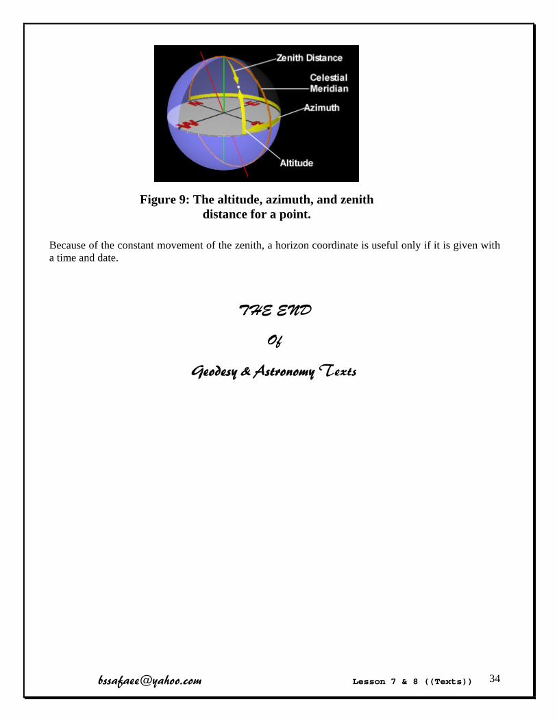
The coordinates in the horizon coordinate system are the altitude and azimuth of a point. Both coordinates are measured in degrees, minutes, and seconds.
The altitude of a point is its angular distance above or below the horizon. It can range from -90 degrees to +90 degrees with the altitude of the zenith being +90 degrees and the altitude of the nadir being -90 degrees. The altitude of any point on the horizon is 0 degrees. The complement to the altitude is the zenith distance, which is sometimes used instead of the altitude. The zenith distance is the angular distance between the zenith and the point. The zenith distance added to the altitude is always 90 degrees.
The azimuth of a point is the angular distance between the north point and the vertical circle which intersects the point. The azimuth is measured in an eastward direction, or clockwise if looking at it from the zenith. The azimuth of the north point is 0 degrees. The azimuth of the east, south, and west points are 90, 180, and 270 respectively. The azimuth, zenith distance, and altitude of a point are illustrated below.
[email protected] Lesson 7 & 8 ((Texts)) 34
Figure 9: The altitude, azimuth, and zenith distance for a point.
Because of the constant movement of the zenith, a horizon coordinate is useful only if it is given with a time and date.
THE END
Of
Geodesy & Astronomy Texts

[email protected] Lesson 9 ((Words)) 35
Technical Language (GPS Glossary) Absolute Positioning
Mode in which a position is determined, using a single receiver, with respect to a well-defined coordinate system, typically a geocentric system. Also referred to as Point Positioning, or Single Receiver Positioning
Acquisition The ability to find and lock on to satellite signals for ranging.
Almanac A data file that contains the approximate orbit information of all satellites, which is transmitted by each satellite within its Navigation Message
Amplitude Amplitude Modulation (AM) Antenna Anti-Spoofing (AS)
Is a policy of the U.S. Department of Defense by which the P-Code is encrypted to protect the militarily important P-Code signals from being "spoofed" through the transmission of false GPS signals by an adversary during times of war.
Ambiguity Carrier phase measurements can only be made in relation to a cycle or wavelength of the L1 or L2 carrier waves because it is impossible to discriminate different carrier cycles. In this case the change in receiver-satellite distance can be measured by counting the number of whole wavelengths since initial signal lock-on and adding the instantaneous fractional phase measurement. However, such a measurement is a biased range or distance measurement because the initial number of whole (integer) wavelengths in the receiver-satellite distance is unknown. This unknown value is referred to as the "ambiguity".
Automatic Vehicle Location (AVL) Baseline
A Baseline consists of a pair of stations for which simultaneous GPS data have been collected.
Base Station Also called a Reference Station. In GPS navigation, this is a receiver that is set up on a known location specifically to collect data for differentially correcting data files of another receiver (which may be referred to as the "mobile" or "rover" receiver). In the case of pseudo-range-based Differential GPS (DGPS) the base station calculates the error for each satellite and, through differential correction, improves the accuracy of GPS positions collected at unknown locations by another (roving) GPS receiver
C/A-Code The standard (Clear/Acquisition or Coarse Acquisition) GPS PRN code, also known as the Civilian Code or S-Code, Only modulated on the L1 carrier.
Carrier Phase GPS measurements made on the L1 or L2 carrier signal,
[email protected] Lesson 9 ((Words)) 36
Clock Bias The difference between the receiver or satellite clock's indicated time and a well-defined time scale reference such as UTC
Control Segment A world-wide network of GPS monitoring and upload telemetry stations operated by, or on behalf of, the US Department of Defense.
Cutoff Angle The minimum acceptable satellite elevation angle (above the horizon) to avoid blockage of line-of-sight, multipath errors or too high Tropospheric or Ionospheric Delay values
Cycle Slip A discontinuity of an integer number of cycles in the measured (integrated) carrier phase resulting from a temporary loss-of-lock in the carrier tracking loop of a GPS receiver.
Demodulation Separating coded data from the carrier signal
Differential GPS (DGPS) A technique to improve GPS accuracy that uses pseudo-range errors measured at a known Base Station location to improve the measurements made by other GPS receivers within the same general geographic area.
Dilution of Precision (DOP) An indicator of satellite geometry for a unique constellation of satellites used to determine a position. Positions tagged with a higher DOP value generally constitute poorer measurement results than those tagged with lower DOP. There are a variety of DOP indicators, such as GDOP (Geometric DOP), PDOP (Position DOP), HDOP (Horizontal DOP), VDOP (Vertical DOP), etc.
Doppler Shift The apparent change in the frequency of a signal caused by the relative motion of the transmitter and receiver
Dual-Frequency Refers to the instrumentation that can make measurements on both L-Band frequencies
Ephemeris (plural: Ephemerides) The file of values from which a satellite's position and velocity (the so-called "satellite state vector") at any instant in time can be obtained
Epoch A specific instant in time, GPS carrier phase measurements are made at a given frequency (e.g. every 30 seconds) or epoch rate.
Global Navigation Satellite System (GNSS) A term used to describe a generic satellite-based navigation/positioning system
Global Orbiting Navigation Satellite System (GLONASS) This is the Russian counterpart to GPS.
Global Positioning System A three-dimensional positioning technique based on the reception and analysis of NAVSTAR satellite signals.
GPS Time (GPST) GPST is a form of Atomic Time, as is, for example, Coordinated Universal Time (UTC).
[email protected] Lesson 9 ((Words)) 37
I/O Abbreviation for Input/Output
Ionosphere, Ionospheric Delay
The Ionosphere is that band of atmosphere extending from about 50 to 1000 kilometers above the earth's surface in which the sun's ultraviolet radiation ionizes gas molecules which then lose an electron. These free electrons influence the propagation of microwave signals (speed, direction and polarization) as they pass through the layer. The Ionospheric Delay on GPS signals is frequency-dependent and hence impacts on the L1 and L2 signals by a different amount.
Local Area Augmentation System (LAAS) Plan by which Local Area Differential GPS (LADGPS), which generates and transmits differential corrections to appropriately equipped aircraft users, is augmented with integrity messages transmitted from the ground and additional ranging signals.
L-Band The group of radio frequencies extending from 390MHz to 1550MHz. The GPS carrier frequencies L1 and L2 are in the L-Band.
Multi-Channel Receiver A GPS receiver that can simultaneously track more than one satellite signal using a dedicated signal electronics channel for each satellite. High quality receivers may have 12 channels for L1, and another 12 channels for L2 signals. Lower quality GPS navigation receivers may have only 6 or 8 channels.
Multipath Interference caused by reflected GPS signals arriving at the receiver, typically as a result of nearby structures or other reflective surfaces
NAVSTAR NAVSTAR is an acronym for NAVigation Satellite Timing and Ranging
OEM Original Equipment Manufacturer
Orbital error P-Code
The Precise or Protected code
Post-Processed GPS In post-processed (Differential or Relative) GPS the base and user (or roving or mobile) receivers have no data communication link between them.
Pseudo-Random Noise (PRN) A binary signal with random noise-like properties
Pseudo-Range A distance measurement based on the correlation of a satellite's transmitted code (may be the C/A-Code or the encrypted P-Code) and the local receiver's reference code (for that PRN satellite number), that has not been corrected for errors in synchronization between the transmitter's clock and the receiver's clock. Hence a pseudo-range measurement is a time-error biased distance measurement.

[email protected] Lesson 9 ((Words)) 38
Range A fixed distance between two points, such as between a starting and an ending waypoint, or a satellite and a GPS receiver
Real Time Kinematic (RTK) The Relative Positioning procedure whereby carrier phase measurements (or corrections) are transmitted in real-time from a Reference or Base Station to the user's roving receiver.
RINEX Receiver INdependent EXchange format. A set of standard definitions and formats to promote the free exchange of GPS data.
Rover Any mobile GPS receiver collecting data during a field session
Selective Availability (SA) Intentional degradation of the Absolute Positioning performance capabilities of the NAVSTAR satellite system for civilian use (the Standard Positioning Service) by the U.S. military
Space Segment The space-based component of the GPS system (i.e., the orbiting satellites and their signals)
Static Positioning Location determination when the receiver's antenna is presumed to be stationary on the earth.
Stop-and-Go Positioning This is a GPS Surveying "high productivity" technique which is used to determine centimeter accuracy baselines to static points, using site observation times of the order of 1 minute.
Track (TRK) The direction of movement relative to a ground position. Commonly associated with navigation applications
Troposphere, Tropospheric Delay The Troposphere is the neutral atmosphere comprising the lower 8km of the atmosphere. The Tropospheric Delay on GPS signals is of the non-dispersive variety because it is not frequency-dependent and hence impacts on both the L1 and L2 signals by the same amount (unlike that within the Ionosphere).
Waypoint A (usually two-dimensional) coordinate that is input into a navigation device, such as a GPS receiver, representing a position that a vessel, aircraft, vehicle or person has to navigate to, with the aid of GPS (and/or any other position fixing device)
Wide Area Augmentation System (WAAS) WAAS is a US Federal Aviation Authority (FAA) funded system of equipment and software that augments GPS accuracy, availability and integrity.
Widelane A linear combination of the L1 and L2 observation (L1 - L2) used to partially remove ionospheric errors.
THE END
Of Gps Vocabylaries

1
Technical Language
Surveying
Software WordsSoftware Words
2
How to Use Help of Software?
1) Tooltip Help
2) Status Bar Help
3
How to Use Help of Software?
3) Software Full Help
4
How to Use Help of Software?
39

5
How to Use Help of Software?4) In Autocad software (command + F1)
6
SDR Mapping & Design
7
SDR Mapping & Design
Job Menu
Heading Maitenance
Merge Purge
Delete Configure
Units statistics
report
8
SDR Mapping & Design
Cad Menu
Add Hatch
Entity change
setting
40

9
SDR Mapping & Design
Tools Menu
Comparison surface
LS XS
Volume import / export
Convert Ascii
10
SDR Mapping & Design
Tools\Contouring\Edit Surface Menu
Create Triangle
Load Tolerance
Swap select
Include boundary
Omit Label Spacing
Breakline height
Interval point
Label Generate
identifier
11
SDR Mapping & Design
Other Vocabularies
Road detail
Update overwrite
Query discard
Version
12
Autocad
41

13
Autocad
14
Autocad
Draw Toolbar
Line
Construction Line
Polyline
Polygon
Rectangle
Arc
Circle
Revision Cloud
Smooth Polyline
Ellipse
Insert Block
Make Block
Point
Hatch
Region
Multiline Text
15
Autocad
Modify Toolbar
Erase
Copy
Mirror
Offset
Array
Move
Rotate
Scale
Stretch
Trim
Extend
Break
Join
Chamfer
Fillet
Explode 16
Autocad
Standard Toolbar
New
Open
save
Plot
Cut
Copy
Paste
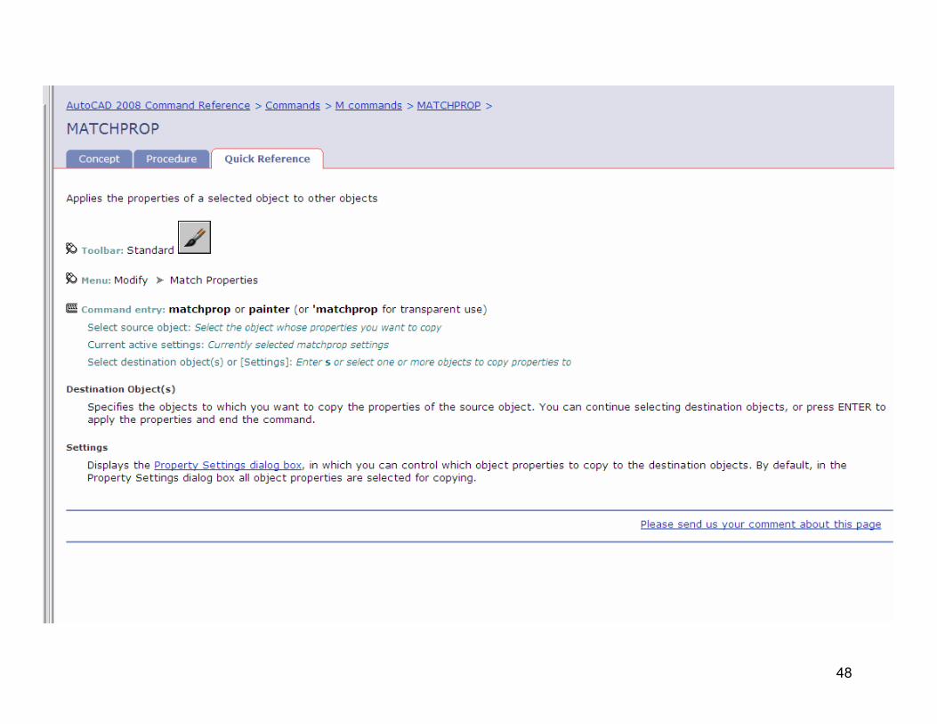
Match Properties
Undo
Redo
pan
Zoom
Properties
Calculator
Help
42

17
AutocadLayers Toolbar
Layer Properties Manager
Freeze
Thaw
Lock
Color
Make Object’s layer current
Layer Previous
Layer state’s Manager 18
Autocad Status Bar
Coordinate
SNAP
GRID
ORTHO
POLAR
OBJECT SNAP
OBJECT TRACK
LINEWEIGHT
19
Autocad Other Toolbars
User Coordinate System
20
Autocad File Menu
Sheet
Load
Set
Import
Style
Publish
Utility
Drawing
Exit
43
21
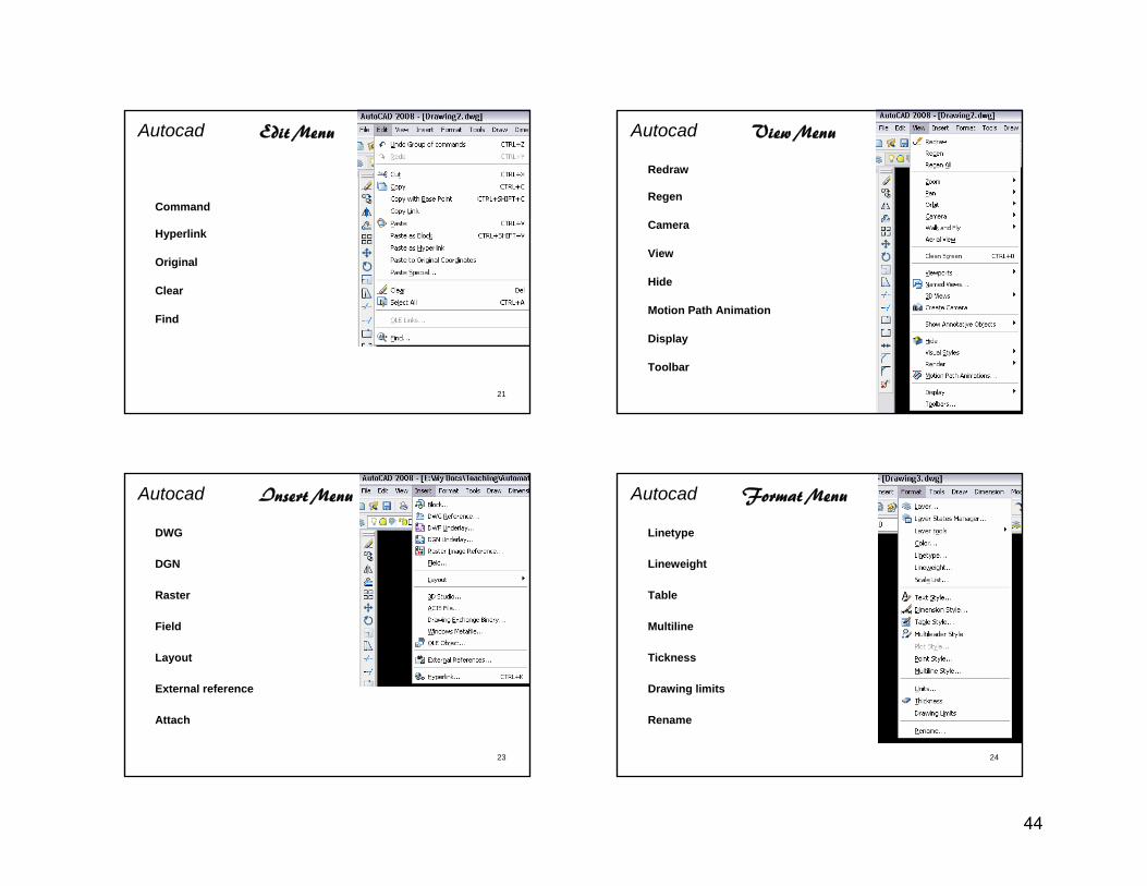
Autocad Edit Menu
Command
Hyperlink
Original
Clear
Find
22
Autocad View Menu
Redraw
Regen
Camera
View
Hide
Motion Path Animation
Display
Toolbar
23
Autocad Insert Menu
DWG
DGN
Raster
Field
Layout
External reference
Attach
24
Autocad Format Menu
Linetype
Lineweight
Table
Multiline
Tickness
Drawing limits
Rename
44

25
Autocad Tools Menu
Workspace Palette
Screen Spelling
Order Extraction
Run Script Macro
Wizard Autolisp
Drafting setting
Customize options
26
Autocad Tools Menu
Distance
Area
Mass
Grip
Display
27
Autocad Draw Menu
Ray Helix
Donut Table
Gradiant Boundary
Wipeout Radius
Center Start
End Tangent
28
Autocad Dimension Menu
Quick Linear
Aligned Ordinate
Diameter Angular
Baseline Leader
Tolerance Oblique
Update associate
45
29
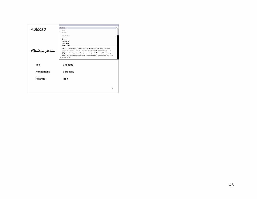
Autocad
Window Menu
Tile Cascade
Horizontally Vertically
Arrange Icon
46

Translation of
Autocad commands help
47
48

3
49

[email protected] Lesson 11 ((Words)) 50
Technical Language (Photogrammetry Glossary) Absolute orientation
The scaling, leveling, and orientation to control points of a relatively oriented stereoscopic model or group of models (Terrazas, 1986: 216)
AERIAL PHOTOGRAPHY Affine transformation
A mathematical operation used to modify a two-dimensional surface.
Air base The distance between the camera positions at which the left and right stereo images are taken
Analogue stereoplotter A stereoplotter implementing all orientations and corrections with optical and mechanical means
Analytical photogrammetry Photogrammetry in which orientations and corrections are performed mathematically rather than with mechanical and optical means
Analytical stereoplotter Base-height ratio (B: H)
Term used for stereo images referring to the ratio between the air base (base distance) and the flying height (camera distance). A recommended value is 1:6.
Camera calibration “The determination of the calibrated focal length, the location of the principal point with respect to the fiducial marks and etc
Check point Points of known three-dimensional coordinate and visible on both stereo images which are used to assess the quality of the absolute orientation solution.
Close-range photogrammetry It applies to terrestrial photogrammetric applications for which the camera-object distance is less than three hundred meters
Conformal transformation Control point
Points of known three-dimensional coordinate and visible on both stereo images which are used to perform the absolute orientation.
Coordinates Values which indicate the location of a point with respect to a chosen system
Cursor Digital orthophoto
An image derived by geometrically correcting a scanned aerial photograph so that it is positionally accurate like a planimetric map

[email protected] Lesson 11 ((Words)) 51
Digitizer A computer-based system to convert point, line and area features from a hardcopy to a digital format.
Distortions Lens aberrations affecting the one-to-one correspondence between a feature and its representation on a photograph The most important ones are radial (symmetric) lens distortions...
DSM Digital surface model
DVP Digital Photogrammetric Mapping Software
Emulsion A suspension of either light-sensitive silver salts which is used for coating photographic film plates and papers
Exposure The act of exposing a sensitized photographic material to a light source
F-number The F-number is the ratio of the lens focal length to the diameter of the lens iris.
Fiducial marks Marks placed on aerial camera film during the exposure.
Flying height The distance between the aircraft and the average terrain elevation of the area photographed is called flying height.
Floating mark A mark seen as occupying a position in the three-dimensional space formed by the stereoscopic fusion of a pair of photographs and used as a reference mark in examining or measuring the stereoscopic model
Focal length GEOREFERENCING
A process of assigning map co-ordinates to image data to conform to map projection grid
Interior orientation “The determining of the interior perspective of the photograph as it was at the instant of exposure. Elements of interior orientation are the calibrated focal length, location of the calibrated principal point, and the calibrated lens distortion”
INS Inertial navigation system
Nadir view Vertical view of a scene (where the viewing angle is 0º from the vertical)
Non-metric and semi-metric cameras Orientation
Orientation is the term used for the cameras position and aiming in space. The orientation of a camera is defined by its coordinates (X,Y,Z) and by its aiming direction (defined by 3 angles).

[email protected] Lesson 11 ((Words)) 52
Orthoimage “A digital orthophoto in which the effects of terrain and geometry of the photograph are removed to produce a plan view (orthographic projection) of the image”
Orthophoto An aerial photo that has been corrected to eliminate the effects of camera tilt and relief displacement
Overlap In aerial photography, the amount by which one photograph includes the same area covered by another, customarily expressed as a percentage. Area covered by two photographs taken in a sequence. ( End Lap & Side Lap )
Parallax The apparent shift of an object as it is observed from different locations.
Principal point The point at which lines drawn between opposing fiducials on an aerial photograph intersect, the center point of an aerial photograph
Pixel A picture element data with assigned intensities representing grey shades (monochromatic) or colors
RECTIFICATION “The process of projecting a tilted or oblique photograph onto a horizontal reference plane”
Relative orientation “The determining of the position and attitude of one of a pair of overlapping photographs with respect to the other photograph”
Relief displacement A characteristic on an aerial photo where features at higher elevations are displaced away from the center of the photo. Relief displacement aids in the calculation of heights of features on an air photo.
Reseau plate A plate on which a grid or cross hairs have been etched and precisely measured +
Resection Resection is the procedure used to get the final position and aiming (called the orientation) of the camera when a picture is taken.
Residual “The difference between any measured quantity and the most probable value for that quantity
RESOLUTION A level of detail in data, For example, ground pixel distance in aerial photography.
Scanner A scanner allows the transfer of a hardcopy image into digital form.
Softcopy photogrammetry The field of softcopy photogrammetry was initiated in the 80’s and is dedicated to the photogrammetry process of digital images
Stereocomparator A stereoscopic instrument for measuring parallax; usually includes a means of measuring photograph coordinates of image points (Terrazas, 1986: 120).
[email protected] Lesson 11 ((Words)) 53
Stereo model The mental impression of an area or object seen as being in three dimensions on photographs when viewed with a stereoscope
Stereo pair A pair of images which are digitally re-sampled to produce a clear stereoscopic model
Stereoscope “A binocular optical instrument for helping an observer to view photographs, or diagrams, to obtain the mental impression of a three-dimensional model
Strip of stereo photographs A series of overlapping photographs taken while moving the camera in one direction and at regular intervals so as to generate a sequence of stereo images
Terrestrial photogrammetry Photogrammetry applied to non-aerial applications is called terrestrial.
TIN (Triangulated Irregular network) A land surface model based on triangles. A specific representation of DTM in which elevation points can occur at irregular intervals
Traditional photogrammetry Vertical exaggeration
The effect of multiplying a scalar number to the elevations at all points in an elevation model in order to exaggerate the landscape's relief.
THE END
Of
Photogrammetry Vocabylaries
[email protected] Lesson 11 ((Texts)) 54
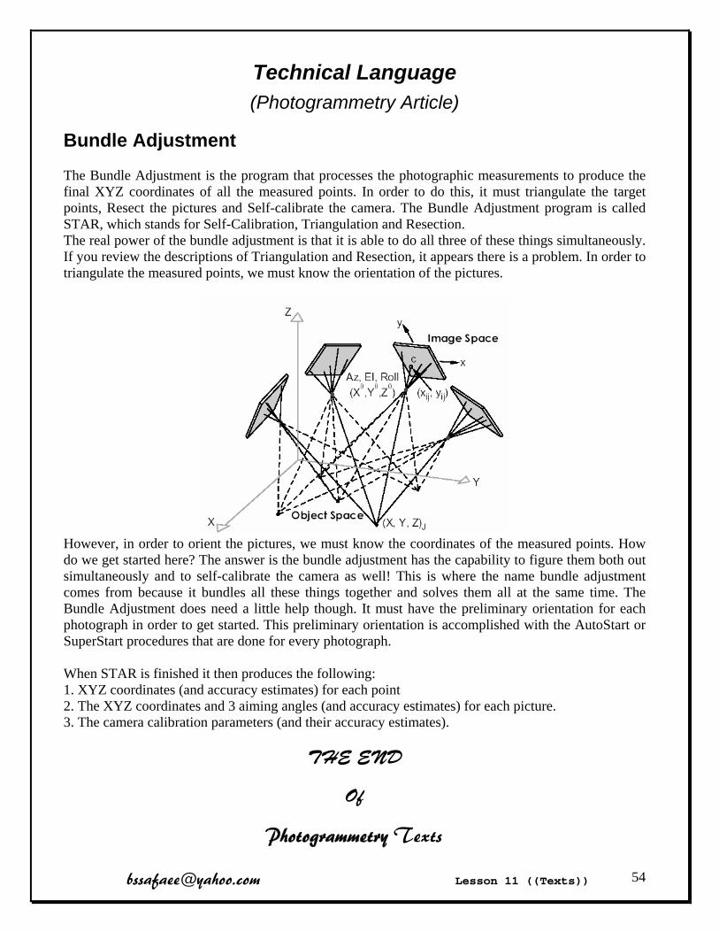
Technical Language (Photogrammetry Article)
Bundle Adjustment
The Bundle Adjustment is the program that processes the photographic measurements to produce the final XYZ coordinates of all the measured points. In order to do this, it must triangulate the target points, Resect the pictures and Self-calibrate the camera. The Bundle Adjustment program is called STAR, which stands for Self-Calibration, Triangulation and Resection. The real power of the bundle adjustment is that it is able to do all three of these things simultaneously. If you review the descriptions of Triangulation and Resection, it appears there is a problem. In order to triangulate the measured points, we must know the orientation of the pictures.
However, in order to orient the pictures, we must know the coordinates of the measured points. How do we get started here? The answer is the bundle adjustment has the capability to figure them both out simultaneously and to self-calibrate the camera as well! This is where the name bundle adjustment comes from because it bundles all these things together and solves them all at the same time. The Bundle Adjustment does need a little help though. It must have the preliminary orientation for each photograph in order to get started. This preliminary orientation is accomplished with the AutoStart or SuperStart procedures that are done for every photograph. When STAR is finished it then produces the following: 1. XYZ coordinates (and accuracy estimates) for each point 2. The XYZ coordinates and 3 aiming angles (and accuracy estimates) for each picture. 3. The camera calibration parameters (and their accuracy estimates).
THE END
Of
Photogrammetry Texts
[email protected] Lesson 12 & 13 ((Words)) 55
Technical Language (RS Glossary) Absorption Active system (active sensor)
A remote-sensing system that transmits its own radiation to detect an object or area for observation and receives the reflected or transmitted radiation
albedo The ratio of the outgoing solar radiation reflected by an object to the incoming solar radiation incident upon it
Azimuth direction In radar images, the direction in which the aircraft is heading. Also called flight direction
Azimuth resolution In radar images, the spatial resolution in the azimuth direction
Backscatter In radar, the portion of the microwave energy scattered by the terrain surface directly back toward the antenna
Blackbody A blackbody is an ideal emitter which absorbs the entire radiant energy incident on it; i.e., no energy is reflected or transmitted.
Band A continuous sequence of broad-casting frequencies within given limits
Bandwidth The total range of frequency
Biomass The amount of living material in unit area or volume, usually expressed as mass or weight.
CLASSIFICATION When image pixels are the same colour, or nearly the same colour, an image "classification" computer program can recognize this and group such pixels together. Such a grouping is called a "class" and the process of doing the grouping is called "classification".
Clustering The analysis of a set of measurements to detect their inherent tendency to form clusters in multispectral space
Corner reflector Cavity formed by two or three smooth planar surfaces intersecting at right angles. Electromagnetic waves entering a corner reflector are reflected directly back toward the source
DETECTION If you are detecting something, you are trying to determine if it is there.
Detector Dielectric constant
Electrical property of matter that influences radar returns.
Diffuse reflector Surface that reflects incident radiation nearly equally in all directions
[email protected] Lesson 12 & 13 ((Words)) 56
Digital number (DN) Value assigned to a pixel in a digital image
Dwell time Time required for a detector IFOV to sweep across a ground resolution cell
ELECTROMAGNETIC SPECTRUM The range of energy which contains parts or "bands" such as the visible, infrared, ultraviolet, microwave (radar), gamma ray, x-ray, radio, and which travels at the speed of light.
Emissivity The ratio of the radiation emitted by a surface to that emitted by a black body at the same temperature
EMIT Enhanced Thematic Mapper Plus (ETM +)
An eight-band multispectral scanning radiometer onboard the Landsat 7 satellite that is capable of providing high-resolution imaging information of the Earth's surface
ENHANCEMENT Anything that you do to an image to make it simpler, faster or more accurate to analyze and interpret by eye is a form of "enhancement
ESA European Space Agency
Evaporation Opposite of condensation
False Color Image An image in which parts of the non-visible EM spectrum are assigned to the red, green, and blue components of the image, so that the colors produced do not match the colors that we see with the naked eye.
Far infrared Electromagnetic radiation, longer than the thermal infrared, with wavelengths between about 25 and 1000 micrometers
Field of view The range of angles that are scanned or sensed by a system or instrument, measured in degrees of arc.
Fog Fourier analysis Geometric correction (or Georeferencing)
The process of geometrically correcting image data so that the resulting image geometry mirrors the ground geometry (i.e. spatial distortions have been corrected).
Geostationary Describes an orbit in which a satellite is always in the same position (appears stationary) with respect to the rotating Earth.

[email protected] Lesson 12 & 13 ((Words)) 57
GROUND TRUTHING Remote sensing analysts must be sure that their image analysis is accurate. This is done by field where they go out to the actual places shown in the images and confirm that what they think they see on the image is actually true.
High-pass filter Spatial filter which selectively enhances contrast variations with high spatial frequencies in an image. It improves the sharpness of images and is a method of edge enhancement.
Histogram A means of expressing the frequency of occurrence of values in a data set within a series of equal ranges or bins, the height of each bin representing the frequency at which values in the data set fall within the chosen range.
Hue In the IHS system, represents the dominant wavelength of a color.
Hyperspectral A sensor is classed as hyperspectral if it is capable of imaging an area in many (e.g. hundreds) of bands simultaneously.
IFOV Instantaneous field of view; that recorded from a small area in a very brief interval of time
IHS Intensity, hue, and saturation system of colors
IMAGE IMAGE ANALYSIS
This is the process of studying an image in order to explain, measure, map, count or monitor what is on the Earth's surface. (Related words: interpretation, classification)
Image processing Encompasses all the various operations that can be applied to producing the final photographic
Image striping A defect produced in line scanner and pushbroom imaging devices produced by the non-uniform response of a single detector, or amongst a bank of detectors.
Incidence angle In radar, the angle formed between an imaginary line normal to the surface and another connecting the antenna and the target.
Infrared (IR) Pertaining to EMR in the 0.7 to 100 µm region of the spectrum
Interpretation The process in which a person extracts information from an image
Kernel Two-dimensional array of digital numbers used in digital filtering
Landsat Land Remote-Sensing Satellite, operated by the U.S. Earth Observation Satellite Company

[email protected] Lesson 12 & 13 ((Words)) 58
Look angle The angle between the vertical plane containing a radar antenna and the direction of radar propagation. Complementary to the depression angle.
Look-up table (LUT) A mathematical formula used to convert one distribution of data to another, most conveniently remembered as a conversion graph.
Microwave Electromagnetic radiation with wavelengths between about 1000 micrometers and one meter
Mid-infrared (MIR) The range of EM wavelengths from 2.5 to 5.6 µm
MOSAIC A big image made by combining smaller images.
Multispectral Scanner (MSS) A line-scanning instrument flown on Landsat satellites that continually scans the Earth in a 185 km. swath. On Landsats 1, 2, 4, and 5, the MSS had four spectral bands in the visible and near-infrared
National Oceanic and Atmospheric Administration (NOAA) NDVI (normalized difference vegetation index)
A model for converting satellite-based measurements into surface vegetation types
Near infrared Electromagnetic radiation with wavelengths from just longer than the visible (about 0.7 micrometers) to about two micrometers
Ozone layer The layer of ozone that begins approximately 15 km above Earth and thins to an almost negligible amount at about 50 km, shields the Earth from harmful ultraviolet radiation from the sun.
Panchromatic Sensitive to all or most of the visible spectrum
Passive remote sensing Remote sensing of energy naturally reflected or radiated from the terrain.
Path-and-row index-System For locating Landsat MSS and TM images
Period Time required for a satellite to make one complete orbit
Pitch Rotation of an aircraft about the horizontal axis normal to its longitudinal axis that causes a nose-up or nose-down attitude.
PIXEL The smallest unit in a digital image
PLATFORM This is what carries a sensor - usually a satellite or an airplane. But a remote sensing platform could also be a hot-air balloon, a tall tower, etc. (related words: satellite, aircraft, sensor)

[email protected] Lesson 12 & 13 ((Words)) 59
Polarization The direction of orientation in which the electrical field vector of electromagnetic radiation vibrates
Principal component analysis The analysis of covariance in a multiple data set so that the data can be projected as additive combinations on to new axes, which express different kinds of correlation among the data
Prograde orbit Orbits of the Earth in the same direction as the rotation of the Earth (west-to-east)
Pushbroom system An imaging device consisting of a fixed linear array of many sensors which is swept across an area by the motion of the platform, thereby building up an image. It relies on sensors whose response and reading is nearly instantaneous, so that the image swathe can be segmented into pixels representing small dimensions on the ground.
Radar Acronym for radio detection and ranging. Radar is an active form of remote sensing that operates in the microwave and radio wavelength regions.
Radar interferometry Radiance
Radiance is the power of EM radiation incident on unit area per unit solid angle in a given direction.
Radiation Range
In radar usage this is the distance in the direction of radar propagation, usually to the side of the platform in an imaging radar system. The slant range is the direct distance from the antenna to the object, whereas the distance from the ground track of the platform to the object is termed the ground range.
Range resolution In radar images, the spatial resolution in the range direction, which is determined by the pulse length of the transmitted microwave energy
Resampling The calculation of new DN for pixels created during geometric correction of a digital scene, based on the values in the local area around the uncorrected pixels.
Resolution A measure of the ability to separate observable quantities
Retrograde orbit An east-to-west orbit of Earth (Earth spins west to east)
Retro-reflective Roll
Rotation of an aircraft that causes a wing-up or wing-down attitude
Satellite A free-flying object that orbits the Earth, another planet, or the sun
SCANNER
[email protected] Lesson 12 & 13 ((Words)) 60
Scattering Multiple reflections of electromagnetic waves by particles in the atmosphere or from surfaces
Sensor Side-looking airborne radar (SLAR)
An airborne side scanning system for acquiring radar images
Shuttle Radar Topography Mission (SRTM) A NASA Space Shuttle mission that used C-band and X-band interferometric synthetic aperture radars (IFSARs) to acquire topographic data over 80% of Earth's land mass (between 60degN and 56degS) between February 11-22, 2000
Spectral band A finite segment of wavelengths in the electromagnetic spectrum
Spectral signature Quantitative measurement of the properties of an object or material over one to several wavelength intervals; the diagnostic spectral response for that entity
SPOT Systeme Pour l'Observation de la Terre. French, polar-orbiting Earth observation satellite(s) with ground resolution of 10 meters.
Sun-synchronous Describes the orbit of a satellite that provides consistent lighting of the Earth-scan view, the satellite passes the equator and each latitude at the same time each day
Supervised classification Digital-information extraction technique in which the operator provides training-site information that the computer uses to assign pixels to categories.
Swath The area observed by a satellite as it orbits the Earth.
Synthetic aperture radar (SAR) A high-resolution ground-mapping technique that effectively synthesizes a large receiving antenna by processing the phase of the reflected radar return
Texture Thematic mapper (TM)
A Landsat multispectral scanner designed to acquire data to categorize the Earth's surface.
Thermal IR Generally, the IR region from 3 to 1000µm; specifically connotes the two intervals employed in remote sensing (3-5 and 8-14 &micr;m)
TOPEX/POSEIDON Ocean Topography Experiment, United States (NASA)/France (CNES). Launched in 1992, the mission carries a radar sensor--called an altimeter--to measure the ocean's surface topography with unprecedented precision.
Tracking and Data Relay Satellite System (TDRSS) TRANSMIT
Energy that passes through an object or material is "transmitted". This is in contrast to energy that may be reflected or absorbed.
[email protected] Lesson 12 & 13 ((Words)) 61
True Color Image An image in which the bands which most closely represent visible red, green, and blue have been assigned to red green and blue, thus producing an image which is similar in colour to what we see with the naked eye
Unsupervised classification Digital information extraction technique in which the computer assigns pixels to categories with no instructions from the operator
UV Ultraviolet region of the electromagnetic spectrum ranging in wavelengths from 0.01 to 0.4m
Vertical exaggeration In a stereo model, the extent to which the vertical scale appears larger than the horizontal scale.
Window A band of EMR which offers maximum obtainable transmission and minimal attenuation through a particular medium with use of a specific sensor; wavelengths of optimum sensing
Yaw Rotation of an aircraft about its vertical axis so that the longitudinal axis deviates left or right from the flight line.
Some Abbreviations & acronyms
AASHTO — American Association of State Highway and Transportation Officials ASTER — Advanced Spaceborne Thermal Emission and Reflection Radiometer AVHRR — advanced very high resolution radiometer AVIRIS — Airborne Visible Infrared Imaging Spectrometer CNES — Centre National d’Etudes Spatiale ENVI — environment for visualizing images EOS — Earth Observing System EROS — Earth Resource Observation System ESA — European Space Agency ESRIN — European Space Research Institute GMS — Geostationary Meteorological Satellite GOES— Geostationary Operational Environmental Satellite IAG — International Association of Geodesy IDL — Interactive Data Language IEEE — Institute of Electrical and Electronics Engineers InSAR —interferometric synthetic aperture radar JPEG — joint photographic expert group JPL — Jet Propulsion Laboratory IMU — inertial measurement unit JPG — joint photographic expert group LAN — local-area network MODIS — Moderate-resolution Imaging Spectroradiometer NASA — National Aeronautics and Space Administration OCR — optical character recognition PDA — personal digital assistant PIN — parcel identification number POES — Polar-orbiting Operational Environmental Satellite
[email protected] Lesson 12 & 13 ((Words)) 62
RAM — random-access memory RF — radio frequency SDTS — spatial data transfer standard SRAM — static RAM TCP/IP — Transmission Control Protocol/Internet Protocol TIFF — tagged image file formatx URL — uniform resource locator VB — Visual Basic XML — extensible markup language
THE END
Of
Remote Sensing Vocabylaries

[email protected] Lesson 12 & 13 ((Words)) 63
Technical Language (GIS Glossary)
Accuracy A/D
Analog-to-digital
Algorithm A set of rules for solving a problem
American Standard Code for Information Interchange (ASCII) A widely used industry standard code for exchanging alphanumeric codes
AM/FM An acronym for automated mapping and facilities management & also for amplitude modulation/frequency modulation
Annotation Descriptive text used to label coverage features.
Application program or package A set of computer programs designed for a specific task.
Arc A locus of points that forms a curve that is defined by a mathematical function
Area A fundamental unit of geographical information
Attribute 1. Non-graphic information associated with a point, line, or area element in a GIS. 2. A characteristic of a geographic feature described by numbers or letters, typically stored in tabular format and linked to the feature in a relational database. The attributes of a well represented by a point might include depth, location, and permit number
Automated cartography The process of drawing maps with the aid of computer driven display devices such as plotters and graphics screens.
b bit
B Byte
Bit map Boolean Arithmetic
Analytical expression that uses a true or false condition It usually contains logical expressions (e.g., Distance from edge > 50 m) and Boolean operators (not, and, or).
CAD Computer-Aided Drafting (Design)
[email protected] Lesson 12 & 13 ((Words)) 64
Cell The basic element of spatial information in the raster (grid) description of spatial entities
Centroid Character
An alphabetical, numerical or special graphic symbol that is treated as a single unit of data
Classification Scheme Hierarchical system of user-defined classes for the classification of remote sensing imagery
Client-Server Clipping
A graphic process of cutting lines and symbols off the edge of a display area
COGO Abbreviation for the term COordinate GeOmetry Land surveyors use COGO functions to enter survey data, to calculate precise locations and boundaries, to define curves, and so on.
Conflation The process whereby two maps of the same area, usually from different time periods or different themes, can be matched and merged together
Connectivity A topological property relating to how geographical features are attached to one another functionally, spatially, or logically
Contiguous Literally adjacent, touching
Conversion The process of transferring data derived from existing records and maps to a digital database.
Coverage One of a series of data themes, such as wetlands or water lines, in a geographic information system with graphic and attribute data related to that topic
Database management systems (DBMS) A set of computer programs for organizing the information in a database. Typically, a DBMS contains routines for data input, verification, storage, retrieval, and combination.
Database A collection of interrelated information, usually stored on some form of mass-storage system such as magnetic tape or disk.
DLL Dynamic link library
Digital Digitizer Download DPI
An abbreviation for dots (or pixels) per inch, a measure of the resolution of graphic displays

[email protected] Lesson 12 & 13 ((Words)) 65
DWG Drawing (file format)
DXF Data Exchange Format
Edge matching The process of ensuring that detail along the edge of two adjacent map sheets matches correctly.
Element A fundamental geographical unit of information, such as a point, line, area, or pixel. May also be known as an entity
Euclidean Distance Distance between objects or values that is computed as a straight line.
Feature Code Field
A specified part of a record containing a unit of data
File A collection of related information in a computer that can be accessed by a unique name
Filter In raster graphics, particularly image processing, a mathematically defined operation for removing long-range (high-pass) or short range (low-pass) variation
Font Format
The way in which data are systematically arranged for storage in a computer and for transmission between computers
Fuzzy Logic A means of quantifying uncertainty
Geocoding The activity of defining the position of geographical objects relative to a standard reference grid
Graphics Interlaced Format (GIF) An 8-bit (256 color) graphic file format, commonly used for web graphics.
Grey scales Levels of brightness (or darkness) for displaying information on monochrome display devices
GUI Graphical User Interface
Hard-copy A copy on paper of a graphics or map image originally displayed on a CRT
Hardware Hierarchical Database
Stores related information in terms of pre-defined categorical relationships in a "tree-like" fashion. Information is traced from a major group, to a subgroup, and to further subgroups.

[email protected] Lesson 12 & 13 ((Words)) 66
Hz Cycles per second, unit for frequency
Infrastructure Refers to the roads, cables, wires, pipes, bridges, canals, reservoirs, and sewers that support economy and society
Input device A hardware component for data entry such as a digitizer, keyboard, scanner, tape drive
Interpolate To estimate the value of an attribute at an unsampled point from measurements made at surrounding sites.
Intersect The topological integration of two spatial data sets that preserves features that fall within the spatial extent common to both input data sets.
ISO International Standards Organization
Jaggies Jargon term for curved lines that have a saw-toothed appearance on a display device.
Joint Photographic Experts Group (JPEG) A compressed image format used on the WWW
Local Area Network (LAN) A communications system that connects computers within a limited geographic area, such as one building or group of buildings
Land parcel A tract of land, being all or part of a legal estate
Layer A logical set of thematic data described and stored in a map library. Layers organize a map library by subject matter, e.g., soils, roads, wells, and extend over the entire geographic area defined by the spatial index of the map library.
Legend The part of the drawn map explaining the meaning of the symbols used to code the depicted geographical elements.
Line One of the basic geographical elements, defined by at least two pairs of XY coordinates.
LIS The acronym for land information system. LIS and GIS are virtually synonymous, although it could be maintained that an LIS is but one component of a GIS.
Macros Are collections of frequently used commands which are grouped together in a file. Instead of entering commands individually, users can call the macro and the commands stored therein will be executed automatically. Macros may be stored in libraries

[email protected] Lesson 12 & 13 ((Words)) 67
Map Cartography; a hand-drawn or printed document describing the spatial distribution of geographical features in terms of a recognizable and agreed symbolism Digital; the collection of digital information about a part of the earth's surface
Map Generalization The process of reducing detail on a map as a consequence of reducing the map scale. The process can be semi-automated for certain kinds of data, such as topographical features, but requires more insight for thematic maps.
Mathematics Meta-Data
Meta-data is data about data. It typically includes information such as currency, accuracy, extent, and collection methodology. Meta-data is typically stored in data models, dictionaries, schemas and other representations.
Modeling The representation of the attributes of the earth as surface in a digital database
Modem Module
A separate and distinct piece of hardware or software that can be connected with other modules to form a system
Network 1. Two or more interconnected computer systems for implementation of specific functions. 2. A set of interconnected lines (arcs, chains, strings) defining the boundaries of polygons.
Network Analysis A range of techniques employed by engineers and planners to study the properties of networks including connectivity, capacity, and rates of flow
Node The point at which areas (lines, chains, strings) in a polygon network are joined
Operating System (OS) Overlay
The process of stacking digital representations of various spatial data on top of each other so that each position in the areas covered can be analyzed in terms of these data.
Peripheral Devices Hardware not part of the central computer e.g. digitizers and plotters
Platform The technology used by an application. E.g. GIS platform is the GIS software and hardware being used.
Plotter A device for outputting hard-copy representations of data e.g. maps
Point A pair of coordinates representing a location with 0 dimensions
Polygon A multi-sided figure representing an area on a map
[email protected] Lesson 12 & 13 ((Words)) 68
Protocol A set of rules or standards which govern communication between computers
Raster-to-vector The process of converting an image made up of cells into one described by lines and polygons
Raster A regular grid of cells covering an area
Record A set of attributes relating to a geographical entity; a set of related, contiguous data in a computer file
Redundancy Relational database
A method of structuring data in the form of sets of records so that relations between different entities and attributes can be used for data access and transformation
RDBMS Relational Database Management System
RGB Red, Green and Blue
Rubber sheeting The transformation of spatial data to stretch or compress them to fit with other data
Scale Scanner
A device for converting images from maps, photographs, or from part of the real world into digital form automatically
Sliver & Gap SQL
Structured Query Language
Tesselation The process of splitting an area into tiles
Thiessen Polygons A method used to divide an area into polygons so that all locations closest to a particular sample point are enclosed within a single polygon. The boundary lines are defined at positions equidistant between two adjacent points.
TIN Triangulated Irregular Network. A series of triangles constructed using elevation data points taken from coverages. These triangles are used for surface representation and display.
Topography Topology
The way in which geographical elements are related to each other
Triangulation A method of surveying in the location of an object may be calculated from the known locations of two other objects. Creating a triangle from the three items, the angles and sides of the triangle can be measured and the location of the unknown object is calculated.
[email protected] Lesson 12 & 13 ((Words)) 69
USGS United States Geological Survey
Vector A geometric element, stored as a point with x,y coordinates within a computer database.
VGA Vector graphics array
WWW World Wide Web
Zoom A capability for proportionately enlarging or reducing the scale of a figure or maps displayed on a CRT.
THE END
Of
GIS Vocabylaries