surveying questions - md nuruzzaman · md nuruzzaman, assistant professor, dept. of civil...
TRANSCRIPT

Md Nuruzzaman, Assistant Professor, Dept. of Civil Engineering, Rangpur Engineering College Page | 1
SURVEYING QUESTIONS
INTRODUCTION
1. Define the terms (i) Representative fraction
2. How will you distinguish between plain scale and diagonal scale?
3. Explain the terms: (i) Graphical scale (ii) Precision and (iii) True Error.
4. Define surveying. Why graphical scales are always on all survey maps?
5. Discuss in brief the principles of surveying.
6. What are different sources of errors in chain surveying?
7. Write short notes on: Compensating error
LINEAR MEASUREMENT
1. Write short note on: Hypotenusal allowance
2. Two adjusted sides and their included angle (α<900) of a triangle are known. Calculate the
length of side opposite to angle α.
3. Differentiate between ranging and chaining. Describe how you would range a chain line
between two points which are not intervisible.
4. Explain the different methods of chaining on a sloping ground.
CHAIN SURVEYING
1. Write short note on: Tie lines
2. Describe with sketches how an obstacle can be crossed over in chain survey when (i) it
interrupts chaining but not ranging (ii) it interrupts ranging but not chaining .
3. What are the points to be kept in mind while selecting survey stations of a chain survey?
4. Define the terms (i) Offset (ii) Field book
5. What is a well-conditioned triangle? Why is it necessary to use well-conditioned triangles?
6. Describe the different types chains used in survey indicating the relative advantages of each.
7. Explain the following terms: (i) Well-conditioned triangle (ii) check line (iii) Offset and (iv)
Optical square.
8. How may a chain be standardized? How may adjustments be made to the chain if it is found to
be long?
Md Nuruzzaman, Assistant Professor, Dept. of Civil Engineering, Rangpur Engineering College Page | 2
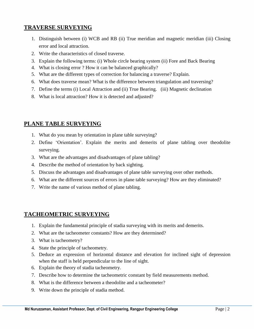
TRAVERSE SURVEYING
1. Distinguish between (i) WCB and RB (ii) True meridian and magnetic meridian (iii) Closing
error and local attraction.
2. Write the characteristics of closed traverse.
3. Explain the following terms: (i) Whole circle bearing system (ii) Fore and Back Bearing
4. What is closing error ? How it can be balanced graphically?
5. What are the different types of correction for balancing a traverse? Explain.
6. What does traverse mean? What is the difference between triangulation and traversing?
7. Define the terms (i) Local Attraction and (ii) True Bearing. (iii) Magnetic declination
8. What is local attraction? How it is detected and adjusted?
PLANE TABLE SURVEYING
1. What do you mean by orientation in plane table surveying?
2. Define ‘Orientation’. Explain the merits and demerits of plane tabling over theodolite
surveying.
3. What are the advantages and disadvantages of plane tabling?
4. Describe the method of orientation by back sighting.
5. Discuss the advantages and disadvantages of plane table surveying over other methods.
6. What are the different sources of errors in plane table surveying? How are they eliminated?
7. Write the name of various method of plane tabling.
TACHEOMETRIC SURVEYING
1. Explain the fundamental principle of stadia surveying with its merits and demerits.
2. What are the tacheometer constants? How are they determined?
3. What is tacheometry?
4. State the principle of tacheometry.
5. Deduce an expression of horizontal distance and elevation for inclined sight of depression
when the staff is held perpendicular to the line of sight.
6. Explain the theory of stadia tacheometry.
7. Describe how to determine the tacheometric constant by field measurements method.
8. What is the difference between a theodolite and a tacheometer?
9. Write down the principle of stadia method.

Md Nuruzzaman, Assistant Professor, Dept. of Civil Engineering, Rangpur Engineering College Page | 3
10. What are the multiplying constant and additive constant of a tacheometer? How would you
obtain these constant in the field?
11. Deduce an expression of horizontal distance and elevation for inclined sight of elevation when
the staff is kept vertical on the ground.
12. What is analletic lens? Write down its advantages and disadvantages.
LEVELLING AND CONTOURING
1. Define contour interval. What are the uses of contouring?
2. Define the following: (i) Parallax (i) Reduced level (ii) Fly levelling (iii) Bench mark (i)
Line of collimation (ii) Datum (iv) Contour Line (i) Dip
3. Name the characteristics of contours.
4. What factors should be considered to select a proper contour interval?
5. Write short notes on: (i)Level line (ii)Contours (iii) Bench mark and (iv) Height of instrument
6. Discuss the effect of curvature and refraction in leveling. Find the correction due to each and
the combined correction.
7. What are the methods of calculation of RL? Distinguish between them.
CALCULATION OF AREAS AND VOLUMES
1. What is prismoid? Derive the prismoidal formula for calculation of volumes.
2. State Simpson’s rule. Derive an expression for it.
CURVES
1. What is shift of a curve? “Transition curve bisects the shift”- Explain.
2. Discuss the different types of problem that are faced on curve setting.
3. Write short notes on (i) Super elevation (ii) Degree of curvature
4. Explain the following terms: (ii) Shift of a curve (iii) Transition curve
5. Derive a relationship between the radius and the degree of a circular curve. What are the
different methods of curve setting?
6. What is shift? Draw a neat sketch of a transition curve and show necessary notations on it.
7. What is initial and final sub-chords?
8. Explain the field procedure of setting out a curve by one-theodolite method.

Md Nuruzzaman, Assistant Professor, Dept. of Civil Engineering, Rangpur Engineering College Page | 4
9. Write down the objectives of providing transition curve.
10. Write down the requirements of transition curve.
11. What is superelevation? Why it is provided?
12. What do you mean by transition curve? Why and where it is provided?
ASTRONOMICAL SURVEYING
1. What are the Napier’s rules for the solution of right angle spherical triangle?
2. Define the following terms; (i) Observer’s meridian (ii) Azimuth (iii) Obliquity of ecliptic.
3. Prove that the altitude of the pole is equal to the latitude of the observer.
4. What is spherical triangle?
5. Write down the properties of a spherical triangle.
6. Explain the following terms: (i) Observer meridian (ii)Spherical excess
7. Define (i) Zenith and Nadir (ii) Sensible Horizon
8. Define the terms: (i) Observer meridian (ii) Altitude (iii) Nautical mile and (iv) Obliquity of
ecliptic (iii) latitude
PHOTOGRAMMETRIC SURVEYING
1. Derive an expression for the length of line between points of different elevations from
measurement on a vertical photograph.
2. Explain the scale of a vertical photograph.
3. What is side lap and over lap? Explain the reasons of over lap.
4. Write short notes on (i) Crab (ii) Drift (i) Overlap
5. Write down the reasons for overlap in aerial photography.
6. How do you determine the number of photograph necessary to cover a given area in an aerial
survey?
7. Differentiate between crab and drift of photographs.
8. Define the following terms: (i) Exposure station
Md Nuruzzaman, Assistant Professor, Dept. of Civil Engineering, Rangpur Engineering College Page | 5
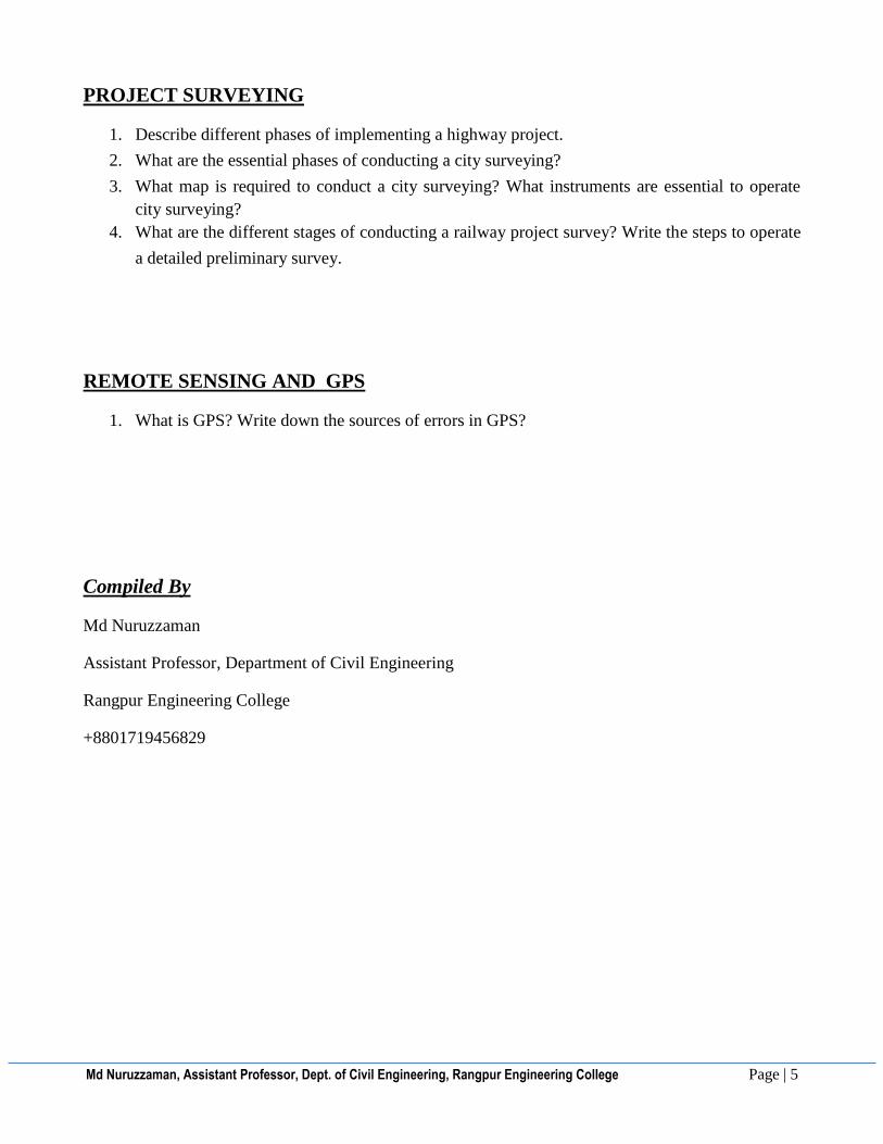
PROJECT SURVEYING
1. Describe different phases of implementing a highway project.
2. What are the essential phases of conducting a city surveying?
3. What map is required to conduct a city surveying? What instruments are essential to operate
city surveying?
4. What are the different stages of conducting a railway project survey? Write the steps to operate
a detailed preliminary survey.
REMOTE SENSING AND GPS
1. What is GPS? Write down the sources of errors in GPS?
Compiled By
Md Nuruzzaman
Assistant Professor, Department of Civil Engineering
Rangpur Engineering College
+8801719456829

Md Nuruzzaman, Assistant Professor, Dept. of Civil Engineering, Rangpur Engineering College Page | 1
SURVEYING PROBLEMS
INTRODUCTION
1. The area of the plan of an old survey plotted to a scale 10 meters to 1cm measures now as
100.2 sq.cm as found by planimeter. The plan is found to have shrunk so that a line originally
10 cm long now measures 9.7cm only. There was a note on the plan that the 20m chain used
was 8cm too short. Find the true area of the survey.
LINEAR MEASUREMENT
2. A base line was measured to be 150m long with a tape at a field temperature of 270C, the
applied pull being 14 kg. The tape was standardized at a temperature of 150C with a pull of
8kg. If the designated length of the tape is 20m, weight of 1 cm3 of tape =7.86 gm, total weight
of tape= 0.8 kg, E=2.109 x 10⁶ kg/cm2 and co-efficient of expansion of tape per degree Celsius
= 11.2 x 10⁻⁶. Find the true length of the line.
3. A steel tape supported on the ground is 33m long at a temperature of 320C and with a pull of
25kg. What horizontal distance will it subtend if it is hung over two poles at the same level
with a pull of 30kg and its temperature is 400C. The weight of the tape is 1.55kg and co-
efficient of linear expansion is 11.5 x 10⁻⁶ per 10C and its E= 2.1 x 10⁶, wt. of 1 cu.cm of steel
=7.75gms.
4. A 20m chain was found to be 10cm too long after chaining a distance of 1500m. It was found
to be 18cm too long at the end of day’s work after chaining a total distance of 2900m. Find the
true distance if the chain was correct before the commencement of the work.
5. In passing an obstacle in the form of a pond, station A and D, on the main line, were taken on
the opposite sides of the pond. On the left of AD, a line AB, 200m long was laid down and a
second line AC, 250m long, was ranged on the right of AD, the points B,D and C being in the
same straight line, BD and DC were then chained and found to be 125m and 150m respectively.
Find the length of AD.
Md Nuruzzaman, Assistant Professor, Dept. of Civil Engineering, Rangpur Engineering College Page | 2
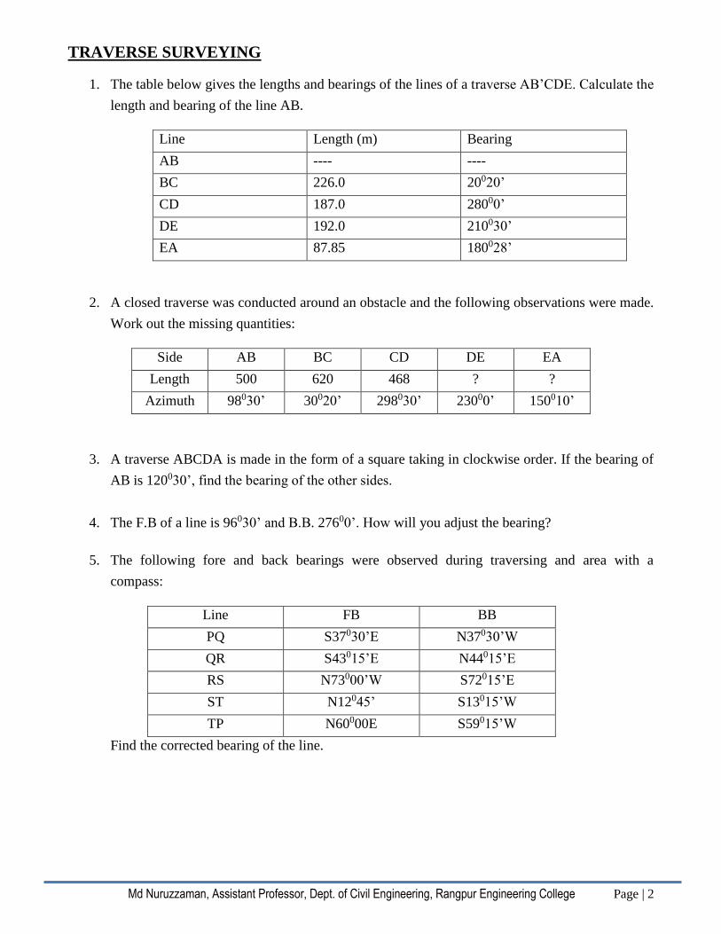
TRAVERSE SURVEYING
1. The table below gives the lengths and bearings of the lines of a traverse AB’CDE. Calculate the
length and bearing of the line AB.
Line Length (m) Bearing
AB ---- ----
BC 226.0 20020’
CD 187.0 28000’
DE 192.0 210030’
EA 87.85 180028’
2. A closed traverse was conducted around an obstacle and the following observations were made.
Work out the missing quantities:
Side AB BC CD DE EA
Length 500 620 468 ? ?
Azimuth 98030’ 30020’ 298030’ 23000’ 150010’
3. A traverse ABCDA is made in the form of a square taking in clockwise order. If the bearing of
AB is 120030’, find the bearing of the other sides.
4. The F.B of a line is 96030’ and B.B. 27600’. How will you adjust the bearing?
5. The following fore and back bearings were observed during traversing and area with a
compass:
Line FB BB
PQ S37030’E N37030’W
QR S43015’E N44015’E
RS N73000’W S72015’E
ST N12045’ S13015’W
TP N60000E S59015’W
Find the corrected bearing of the line.
Md Nuruzzaman, Assistant Professor, Dept. of Civil Engineering, Rangpur Engineering College Page | 3
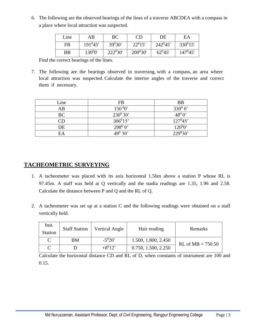
6. The following are the observed bearings of the lines of a traverse ABCDEA with a compass in
a place where local attraction was suspected.
Line AB BC CD DE EA
FB 191045' 39030' 22015' 242045' 330015'
BB 13000' 222030' 200030' 62045' 147045'
Find the correct bearings of the lines.
7. The following are the bearings observed in traversing, with a compass, an area where
local attraction was suspected. Calculate the interior angles of the traverse and correct
them if necessary.
Line FB BB
AB 150 00’ 3300 0’
BC 2300 30’ 480 0’
CD 306015’ 127045’
DE 2980 0’ 12000’
EA 490 30’ 229030’
TACHEOMETRIC SURVEYING
1. A tacheometer was placed with its axis horizontal 1.56m above a station P whose RL is
97.45m. A staff was held at Q vertically and the stadia readings are 1.35, 1.96 and 2.58.
Calculate the distance between P and Q and the RL of Q.
2. A tacheometer was set up at a station C and the following readings were obtained on a staff
vertically held.
Inst.
Station Staff Station Vertical Angle Hair reading Remarks
C BM -5020’ 1.500, 1.800, 2.450 RL of MB = 750.50
C D +8012’ 0.750, 1.500, 2.250
Calculate the horizontal distance CD and RL of D, when constants of instrument are 100 and
0.15.
Md Nuruzzaman, Assistant Professor, Dept. of Civil Engineering, Rangpur Engineering College Page | 4
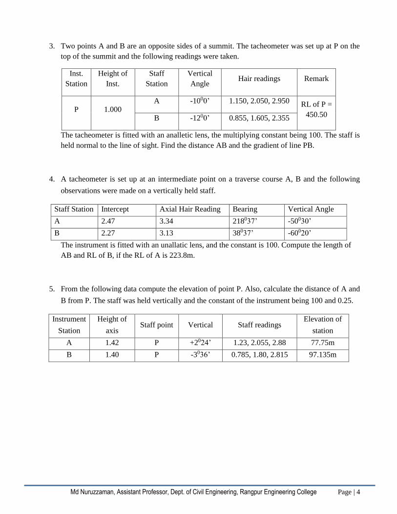
3. Two points A and B are an opposite sides of a summit. The tacheometer was set up at P on the
top of the summit and the following readings were taken.
Inst.
Station
Height of
Inst.
Staff
Station
Vertical
Angle Hair readings Remark
P 1.000 A -1000’ 1.150, 2.050, 2.950 RL of P =
450.50 B -1200’ 0.855, 1.605, 2.355
The tacheometer is fitted with an analletic lens, the multiplying constant being 100. The staff is
held normal to the line of sight. Find the distance AB and the gradient of line PB.
4. A tacheometer is set up at an intermediate point on a traverse course A, B and the following
observations were made on a vertically held staff.
Staff Station Intercept Axial Hair Reading Bearing Vertical Angle
A 2.47 3.34 218037’ -50030’
B 2.27 3.13 38037’ -60020’
The instrument is fitted with an unallatic lens, and the constant is 100. Compute the length of
AB and RL of B, if the RL of A is 223.8m.
5. From the following data compute the elevation of point P. Also, calculate the distance of A and
B from P. The staff was held vertically and the constant of the instrument being 100 and 0.25.
Instrument
Station
Height of
axis Staff point Vertical Staff readings
Elevation of
station
A 1.42 P +2024’ 1.23, 2.055, 2.88 77.75m
B 1.40 P -3036’ 0.785, 1.80, 2.815 97.135m

Md Nuruzzaman, Assistant Professor, Dept. of Civil Engineering, Rangpur Engineering College Page | 5
LEVELLING AND CONTOURING
1. In a leveling operation, the B.M. (RL 50.525m) is 1.235m below the line of collimation in a
setting of the level. From this set-up the stat reading 1.285, 3.2, 3, 2.875 and 3.105 were taken
on points A,B,C and D respectively. Calculate the RL of A, B, C and D which are 15m apart
from one another, after entering them in a level book form. Apply necessary arithmetic checks.
2. In a leveling operation the B.M. (RL=150.5ft) is 3.2ft below the height of the instrument in a
setting of the instrument. From this set up of the instrument the staff reading 4.72, 9.60, 7.82
and 8.78 were taken on points A,B,C and D respectively. Calculate the R.L. of A,B,C and D
which are 50ft apart from one another, after entering them in a level book form. Apply
necessary arithmetic checks.
3. The following consecutive readings were taken with a level and a 4 meter leveling staff
on a continuously sloping ground at common intervals of 30m: 0.855(on A),1.545, 2.335,
3.115, 3.825, 0.455, 1.380, 2.055, 2.855, 3.455, 0.585, 1.015,1.850, 2.755, 3.845(on B). The
RL of A was 380.50. Make entries in a level book and apply the usual checks. Determine the
gradient of AB.
4. To a person standing on the deck of a ship, a light from the top of a light house is visible just
above the horizon. The height of the light in the light house is known to be 233 yards above
M.S.L. if the deck of the ship is 9 yards above M.S.L., work out the distance between the light
house and the ship. Make necessary assumptions. An
observer standing on the deck of a ship just sees a light house. The top of the light house is 42
meters above the sea level and the height of the observer’s eye is 6m above the sea level. Find
the distance of the observer from the light house.
5. The observation between two triangulation station A and B just grazes the sea. If the heights of
A and B are 800m and 400m respectively, determine the distance between A and B.
6. The observation ray between two triangulation stations A and B just grazes the sea. If the
heights of A and B are 9000 meters respectively, determine approximately the distance between
A and B.
7. Find the error of reading of a level staff if the observed reading is 12.64 ft and the point
sighted, the staff is 6” off the vertical through the bottom.
8. A vertical parabola 400m long is to be put in between a 2% upgrade and 1% downgrade, which
meet at chainage 2000 m. The RL of the point of instruction of the two gradients being 500m.
Calculate the R.L. of the tangent points and at every 50m along the parabola.

Md Nuruzzaman, Assistant Professor, Dept. of Civil Engineering, Rangpur Engineering College Page | 6
CALCULATION OF AREAS AND VOLUMES
1. The following perpendicular offsets were taken from a chain to an irregular boundary:
Chainage 0 10 25 44 60 75m
Offset 15.5 26.4 31.8 25.6 29.5 31.4
Calculate the area between the chain line, the boundary and the offsets.
2. The following offsets were taken at 12m intervals from a survey line to an irregular boundary
line: 3.5, 4.3, 6.7, 5.3, 8.8, & 7.9m. Calculate the area enclosed between survey lines, the
irregular boundary line and the first and last offsets by the (i) Trapezoidal rule (ii) Simpson’s
rule. 3. An excavation is to be made for a reservoir 26m long and 15m wide at the bottom, of side slope
2:1. Calculate the volume of excavation if the depth is 4m. Assume that the ground surface is
level before excavation.
4. An excavation is to be made for a reservoir 30m long and 20m wide at the bottom. The side
slope of the excavation has to be 3:1. Calculate the volume of earth work by prismoidal
formula with seven ordinates. The depth of excavation is 6m and ground is level at the site.
5. Calculate the volume of earthwork in cutting for a road at a constant R.L. of 180.00 which runs
East to West. The ground is leveled in North South direction. The surface levels along the
center line of the road are as follows:
Chainage
in ft 0 50 100 150 200 250 300
Level in
ft 190 188 187 185 186 182 184
6. A coastal embankment at a constant reduce level of 65.00 is to be constructed. The transverse
ground is leveled. The following are the levels of the ground surface along the alignment at
50ft interval. The width of the formation level is 25ft, side slope 2:1.
Chainage 0 50 100 150 200 250 300 350 400
Surface level 58 56 54 50 48 52 57 58 54
Calculate the volume of earthwork.

Md Nuruzzaman, Assistant Professor, Dept. of Civil Engineering, Rangpur Engineering College Page | 7
7. The areas enclosed by the contours in a lake are as follows:
Contour (m) 270 275 280 285 290
Area (m2) 2,050 8,400 16,300 24,600 31,000
Calculate the volume of water between the contours 270m and 290m by (i) Trapezoidal & (ii)
Prismoidal formula.
CURVES
1. Two tangents intersect at chainage 1050m. The angle of intersection is 1500. Calculate all data
necessary for setting out a curve of radius 250m by the deflection angle method. The peg
intervals may be taken as 20m. Prepare a setting out table when the least count of the vernier is
20”. Calculate the data for field checking.
2. Two tangents intersect at a chainage of 1000m, the deflection angle being 300. Calculate all
necessary data for setting out a circular curve of radius 200m by the method of offsets from the
chord produced, taking a peg interval of 20m. Two
tangents intersect at chainage 1250m. The angle of intersection is 1500. Calculate all data
necessary for setting out a curve of radius 250m by the deflection angle method. The peg
intervals may be taken as 20m. Prepare a setting out table when the least count of the vernier is
20’’.
3. Calculate the ordinates at 10m distances for a circular curve having a long chord 80m and a
versed sine of 4m.
4. Calculate the ordinates at 25m interval to set up a circular curve having a long chord of 300m
and a versed sine of 10m.
5. A transition curve is required for a circular curve of 200m radius. The gauge being 1.5m and
maximum super-elevation restricted to 15cm. The transition is to be designed for a velocity
such that no lateral pressure is imposed on the rails and the rate of gain of radial acceleration is
30 cm/sec3. Calculate the required length of the transition curve and the design speed.
ASTRONOMICAL SURVEYING
1. Find the shortest distance between two places A and B, given that the latitude of A and B are
150N and 1206’N and their longitude are 50012’E and 5400’E respectively. Radius of earth is
6370 km.
2. Find the shortest distance between two places A and B. Given that, the latitudes of A & B are
150N & 1206’N and longitudes are 50012’E & 5400’E respectively. Find also the direction of B
on the …..circle route, where R= 6370 km.

Md Nuruzzaman, Assistant Professor, Dept. of Civil Engineering, Rangpur Engineering College Page | 8
3. Following data are available for a right angled spherical triangle APB. Lat. Of a =+400. Lat. Of
P=+900.PAB =900 and point B is 340 nautical mile East from point A. Calculate the other
angles and sides by Napier’s rules of circular pass.
4. Following data are available for a right angled spherical triangle PAB. PAB= 900, Lat. Of A
=400N, Lat of P= 900 and point B is 350 nautical mile East from point A. Calculate the other
angles and sides by Napier’s rules of circular parts.
5. The standard time meridian in Bangladesh is +90023’. Find the GMT for standard time 10h
25m 30s AM in Bangladesh.
6. The standard time meridian in Bangladesh is 90023’E. Find the G.M.T. for standard time 3h
20m 30s P.M. in Bangladesh.
7. Find the GMT corresponding to the following LMT (i) 9h 49m 12s AM at a place in long
42036’W (ii) 4h 32m 10s at a place in long 56032’E
PHOTOGRAMMETRIC SURVEYING
1. A line AB, 2000m long, lying at an elevation of 5000m measures 8.65 cm on a vertical
photograph for which focal length is 20 cm. Determine the scale of photograph in an area the
average elevation of which is about 800m.
2. The scale of an aerial photography is 1cm=100m. The photograph size is 20cm x 20cm.
Determine the number of photographs required to cover an area of 10 km x 10 km, if
longitudinal lap is 60% and the side lap is 30%.
3. An area 30km x 25 km is to be photographed by 20cm x 20cm size photograph. Scale is 1cm =
120m. Calculate the (i) Number of flight lines required (ii) Number of Photograph per flight
line. Assume overlap= 60% and side lap =30%.
4. An area 35km x35km is to be photographed by 20m x 20cm size photograph. Scale is 1cm =
160m. Calculate the (i) Number of flight lines required (ii) Number of photographs per flight
lines and (iii) Total number of photographs required.
Compiled By
Md. Nuruzzaman
Assistant Professor, Department of Civil Engineering
Rangpur Engineering College
+8801719456829